Bridge Statistics for Wellton, Arizona (AZ)
Condition, Traffic, Stress, Structural Evaluation, Project Costs
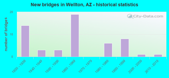
- New bridges - historical statistics
- 141930-1939
- 31940-1949
- 31950-1959
- 191960-1969
- 61980-1989
- 81990-1999
- 12000-2009
- 12010-2019
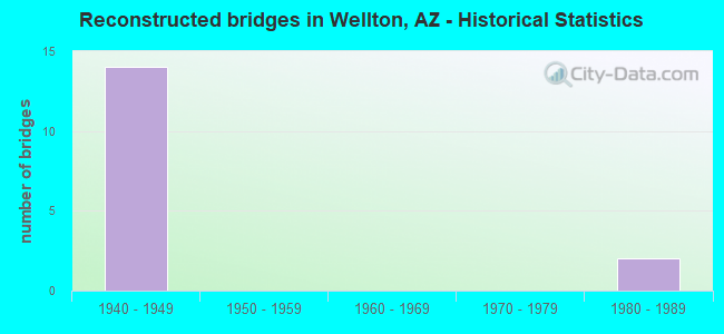
- Reconstructed bridges - Historical Statistics
- 141940-1949
- 01950-1959
- 01960-1969
- 01970-1979
- 21980-1989
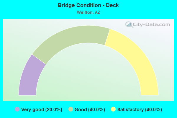
- Bridge Condition - Deck
- 20.0%Very good
- 40.0%Good
- 40.0%Satisfactory
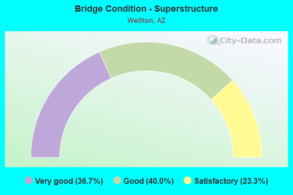
- Bridge Condition - Superstructure
- 36.7%Very good
- 40.0%Good
- 23.3%Satisfactory
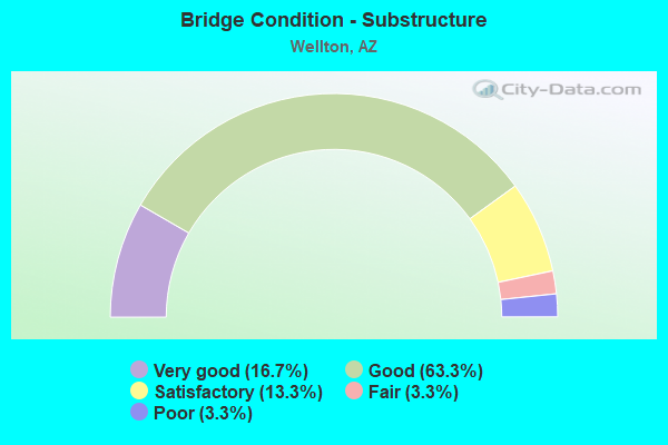
- Bridge Condition - Substructure
- 16.7%Very good
- 63.3%Good
- 13.3%Satisfactory
- 3.3%Fair
- 3.3%Poor
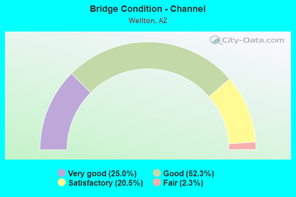
- Bridge Condition - Channel
- 25.0%Very good
- 52.3%Good
- 20.5%Satisfactory
- 2.3%Fair
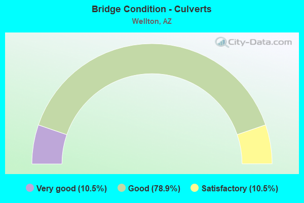
- Bridge Condition - Culverts
- 10.5%Very good
- 78.9%Good
- 10.5%Satisfactory
Find on map >> Show street view
Structure Number: 8942, Location: S Jct Co. 8th St (Lat: 32.706953, Lng: -114.278983), Route carried "on" structure: County highway , Year Built: 1989, Status: Open, Structure Length: 1.01m (3.31ft), Average Daily Traffic: 100 (year 2017), Truck Traffic: 1%, Average Future Daily Traffic: 110 (year 2037), Design Load: HS 20, Features Intersected: Dome Lateral, Facility Carried by Structure: Avenue 21E
Minimum Vertical Clearance: 30+ m (98+ ft), Kilometerpoint: 0.000, Lanes on structure: 2, Owner: County Highway Agency, Approaching Roadway Width: 7.3m (24.0ft), Material/Design: Prestressed concrete, Design/Construction: Box Beam or Girders - Multiple, Number Of Spans In Main Unit: 1, Length of Maximum Span: 9.1m (29.9ft), Curb-To-Curb Width: 9.0m (29.5ft), Out-to-Out Width: 9.8m (32.2ft)
Condition: Deck: Good, Superstructure: Good, Substructure: Good, Channel: Very good, Operating Rating: 66.2 metric tons, Method Used To Determine Operating Rating: Load Factor (LF), Inventory Rating: 38.1 metric tons, Method Used To Determine Inventory Rating: Load Factor (LF), Structural Evaluation: Better than present minimum criteria, Deck Geometry: Better than present minimum criteria, Waterway Adequacy: Equal to present desirable criteria, Approach Roadway Alignment: Equal to present minimum criteria, Designated Inspection Frequency: Every 24 months, Inspection Date: January 2021, Deck Structure Type: Concrete Cast-file-Place, Wearing Surface/Protective System: Wearing Surface: Bituminous
Find on map >> Show street view
Structure Number: 8943, Location: 1.2 mi E Jct Ave 22E (Lat: 32.678136, Lng: -114.241164), Route carried "on" structure: County highway , Year Built: 1989, Status: Open, Structure Length: 1.16m (3.81ft), Average Daily Traffic: 115 (year 2020), Average Future Daily Traffic: 125 (year 2040), Design Load: HS 20, Features Intersected: Salinity Canal, Facility Carried by Structure: 10th Street
Minimum Vertical Clearance: 30+ m (98+ ft), Kilometerpoint: 0.000, Lanes on structure: 2, Owner: County Highway Agency, Approaching Roadway Width: 7.3m (24.0ft), Material/Design: Prestressed concrete, Design/Construction: Box Beam or Girders - Multiple, Number Of Spans In Main Unit: 1, Length of Maximum Span: 10.7m (35.1ft), Curb-To-Curb Width: 9.0m (29.5ft), Out-to-Out Width: 9.8m (32.2ft)
Condition: Deck: Very good, Superstructure: Good, Substructure: Good, Channel: Good, Operating Rating: 70.8 metric tons, Method Used To Determine Operating Rating: Load Factor (LF), Inventory Rating: 41.7 metric tons, Method Used To Determine Inventory Rating: Load Factor (LF), Structural Evaluation: Better than present minimum criteria, Deck Geometry: Equal to present minimum criteria, Waterway Adequacy: Equal to present desirable criteria, Approach Roadway Alignment: Equal to present minimum criteria, Designated Inspection Frequency: Every 24 months, Inspection Date: March 2020, Deck Structure Type: Concrete Cast-file-Place, Wearing Surface/Protective System: Wearing Surface: Bituminous
Find on map >> Show street view
Structure Number: 9751, Location: 1.5 mi NW Jct Old US 80 (Lat: 32.689389, Lng: -114.296111), Route carried "on" structure: County highway , Year Built: 1982, Status: Open, Structure Length: 7.44m (24.41ft), Average Daily Traffic: 400 (year 2015), Truck Traffic: 5%, Average Future Daily Traffic: 410 (year 2035), Design Load: HS 20, Features Intersected: Gila River, Facility Carried by Structure: Avenue 20E
Minimum Vertical Clearance: 30+ m (98+ ft), Kilometerpoint: 0.000, Lanes on structure: 2, Owner: County Highway Agency, Approaching Roadway Width: 9.1m (29.9ft), Material/Design: Prestressed concrete, Design/Construction: Box Beam or Girders - Multiple, Number Of Spans In Main Unit: 4, Length of Maximum Span: 18.3m (60.0ft), Curb-To-Curb Width: 9.1m (29.9ft), Out-to-Out Width: 9.8m (32.2ft)
Condition: Deck: Very good, Superstructure: Good, Substructure: Good, Channel: Good, Operating Rating: 84.4 metric tons, Method Used To Determine Operating Rating: Load Factor (LF), Inventory Rating: 42.6 metric tons, Method Used To Determine Inventory Rating: Load Factor (LF), Structural Evaluation: Better than present minimum criteria, Deck Geometry: Equal to present minimum criteria, Waterway Adequacy: Equal to present minimum criteria, Approach Roadway Alignment: Better than present minimum criteria, Designated Inspection Frequency: Every 24 months, Inspection Date: January 2021, Deck Structure Type: Concrete Precast Panels, Wearing Surface/Protective System: Wearing Surface: Bituminous
Find on map >> Show street view
Structure Number: 10146, Location: 0.5 mi N Jct Co 9th St (Lat: 32.699900, Lng: -114.261800), Route carried "on" structure: County highway , Year Built: 1999, Status: Open, Structure Length: 0.98m (3.22ft), Average Daily Traffic: 110 (year 2021), Truck Traffic: 1%, Average Future Daily Traffic: 120 (year 2041), Design Load: HS 20, Features Intersected: Dome Lateral, Facility Carried by Structure: Avenue 22E
Minimum Vertical Clearance: 30+ m (98+ ft), Kilometerpoint: 0.000, Lanes on structure: 2, Owner: County Highway Agency, Approaching Roadway Width: 7.3m (24.0ft), Material/Design: Wood or Timber, Design/Construction: Slab, Number Of Spans In Main Unit: 1, Length of Maximum Span: 8.8m (28.9ft), Curb-To-Curb Width: 9.8m (32.2ft), Out-to-Out Width: 10.3m (33.8ft)
Condition: Deck: Good, Superstructure: Very good, Substructure: Very good, Channel: Very good, Operating Rating: 82.6 metric tons, Method Used To Determine Operating Rating: Load Factor (LF), Inventory Rating: 49.0 metric tons, Method Used To Determine Inventory Rating: Load Factor (LF), Structural Evaluation: Equal to present desirable criteria, Deck Geometry: Better than present minimum criteria, Waterway Adequacy: Equal to present desirable criteria, Approach Roadway Alignment: Equal to present desirable criteria, Designated Inspection Frequency: Every 24 months, Inspection Date: January 2021, Deck Structure Type: Wood or Timber, Wearing Surface/Protective System: Wearing Surface: Bituminous
Find on map >> Show street view
Structure Number: 10548, Location: 0.5 mi N Jct Co 8th St (Lat: 32.714336, Lng: -114.278975), Route carried "on" structure: County highway , Year Built: 2008, Status: Open, Structure Length: 1.52m (4.99ft), Average Daily Traffic: 80 (year 2020), Truck Traffic: 1%, Average Future Daily Traffic: 90 (year 2040), Design Load: H 20, Features Intersected: Wellton Mohawk Main C Ch, Facility Carried by Structure: Avenue 21E Roadway
Minimum Vertical Clearance: 30+ m (98+ ft), Kilometerpoint: 0.000, Lanes on structure: 2, Owner: County Highway Agency, Approaching Roadway Width: 6.7m (22.0ft), Material/Design: Prestressed concrete, Design/Construction: Box Beam or Girders - Multiple, Number Of Spans In Main Unit: 1, Length of Maximum Span: 14.3m (46.9ft), Curb-To-Curb Width: 10.4m (34.1ft), Out-to-Out Width: 11.0m (36.1ft)
Condition: Deck: Very good, Superstructure: Very good, Substructure: Good, Channel: Satisfactory, Operating Rating: 89.8 metric tons, Method Used To Determine Operating Rating: Load Factor (LF), Inventory Rating: 51.7 metric tons, Method Used To Determine Inventory Rating: Load Factor (LF), Structural Evaluation: Better than present minimum criteria, Deck Geometry: Superior to present desirable criteria, Waterway Adequacy: Equal to present minimum criteria, Approach Roadway Alignment: Equal to present minimum criteria, Designated Inspection Frequency: Every 24 months, Inspection Date: March 2020, Deck Structure Type: Concrete Cast-file-Place, Wearing Surface/Protective System: Wearing Surface: Monolithic Concrete
Find on map >> Show street view
Structure Number: 10549, Location: 1.7 mi E Jct I-8 (Lat: 32.672714, Lng: -114.275286), Route carried "on" structure: ServiceCounty highway 80, Year Built: 2010, Status: Open, Structure Length: 6.31m (20.70ft), Average Daily Traffic: 2,100 (year 2021), Truck Traffic: 10%, Average Future Daily Traffic: 2,110 (year 2041), Design Load: HS 20, Features Intersected: Red Top Wash
Minimum Vertical Clearance: 30+ m (98+ ft), Kilometerpoint: 0.000, Lanes on structure: 2, Owner: County Highway Agency, Approaching Roadway Width: 11.0m (36.1ft), Skew: 3 degrees, Material/Design: Prestressed concrete continuous, Design/Construction: Stringer/Multi-beam, Number Of Spans In Main Unit: 2, Length of Maximum Span: 30.5m (100.1ft), Curb-To-Curb Width: 12.2m (40.0ft), Out-to-Out Width: 13.0m (42.7ft)
Condition: Deck: Good, Superstructure: Very good, Substructure: Very good, Channel: Good, Operating Rating: 89.8 metric tons, Method Used To Determine Operating Rating: Load Factor (LF), Inventory Rating: 39.0 metric tons, Method Used To Determine Inventory Rating: Load Factor (LF), Structural Evaluation: Equal to present desirable criteria, Deck Geometry: Equal to present minimum criteria, Waterway Adequacy: Equal to present minimum criteria, Approach Roadway Alignment: Better than present minimum criteria, Designated Inspection Frequency: Every 24 months, Inspection Date: January 2021, Deck Structure Type: Concrete Cast-file-Place, Wearing Surface/Protective System: Wearing Surface: Bituminous
Find on map >> Show street view
Structure Number: 133, Location: 24.5 mi E Jct US 95 (Lat: 32.649000, Lng: -114.210500), Route carried "under" structure: County highway , Year Built: 1965, Structure Length: 0. m, Average Daily Traffic: 200 (year 2013), Truck Traffic: 10%, Features Intersected: Ave 25E, Facility Carried by Structure: I-8 EB
Minimum Vertical Clearance: 5.61m (18.41ft), Kilometerpoint: 0.000, Lanes on structure: 2, Lanes under structure: 2, Material/Design: Concrete continuous, Design/Construction: Slab, Length of Maximum Span: 12.2m (40.0ft)
Find on map >> Show street view
Structure Number: 1331, Location: 24.5 mi E Jct US 95 (Lat: 32.649300, Lng: -114.210400), Route carried "under" structure: County highway , Year Built: 1965, Structure Length: 0. m, Average Daily Traffic: 200 (year 2013), Truck Traffic: 10%, Features Intersected: Ave 25E, Facility Carried by Structure: I-8 WB
Minimum Vertical Clearance: 5.87m (19.26ft), Kilometerpoint: 0.000, Lanes on structure: 2, Lanes under structure: 2, Material/Design: Concrete continuous, Design/Construction: Slab, Length of Maximum Span: 12.2m (40.0ft)
Find on map >> Show street view
Structure Number: 1332, Location: 28.6 mi E Jct US 95 (Lat: 32.661500, Lng: -114.142200), Route carried "under" structure: Interstate 8, Year Built: 1965, Structure Length: 0. m, Average Daily Traffic: 11,842 (year 2017), Truck Traffic: 26%, Features Intersected: I-8, Facility Carried by Structure: Ave 29E
Minimum Vertical Clearance: 5.00m (16.40ft), Kilometerpoint: 49.568, Lanes on structure: 2, Lanes under structure: 4, Material/Design: Concrete continuous, Design/Construction: Tee Beam, Length of Maximum Span: 24.7m (81.0ft)
Find on map >> Show street view
Structure Number: 1335, Location: 30.7 mi E Jct US 95 (Lat: 32.669600, Lng: -114.107900), Route carried "under" structure: Interstate 8, Year Built: 1965, Structure Length: 0. m, Average Daily Traffic: 11,842 (year 2017), Truck Traffic: 26%, Features Intersected: I-8, Facility Carried by Structure: Ave 31E
Minimum Vertical Clearance: 5.08m (16.67ft), Kilometerpoint: 52.931, Lanes on structure: 2, Lanes under structure: 4, Material/Design: Concrete continuous, Design/Construction: Box Beam or Girders - Single/Spread, Length of Maximum Span: 25.9m (85.0ft)
Find on map >> Show street view
Structure Number: 1336, Location: 32.7 mi E Jct US 95 (Lat: 32.674000, Lng: -114.073600), Route carried "under" structure: Interstate 8, Year Built: 1964, Structure Length: 0. m, Average Daily Traffic: 11,842 (year 2017), Truck Traffic: 26%, Features Intersected: I-8; Old US80; UPRR, Facility Carried by Structure: Ave 33E
Minimum Vertical Clearance: 6.76m (22.18ft), Kilometerpoint: 56.182, Lanes on structure: 2, Lanes under structure: 6, Material/Design: Prestressed concrete, Design/Construction: Stringer/Multi-beam, Length of Maximum Span: 23.8m (78.1ft)
Find on map >> Show street view
Structure Number: 8406, Location: 0.7 mi NE Jct I-8 (Lat: 32.674722, Lng: -114.292492), Route carried "under" structure: County highway 556, Year Built: 1949, Structure Length: 0. m, Average Daily Traffic: 2,100 (year 2015), Truck Traffic: 5%, Features Intersected: Old US 80, Facility Carried by Structure: Ligurta SPRR
Minimum Vertical Clearance: 4.31m (14.14ft), Kilometerpoint: 1.127, Lanes under structure: 2, Material/Design: Steel, Design/Construction: Stringer/Multi-beam, Length of Maximum Span: 11.9m (39.0ft)