Bridge Statistics for Weston, Missouri (MO)
Condition, Traffic, Stress, Structural Evaluation, Project Costs
- National Bridge Inventory (NBI) Statistics
- 17Number of bridges
- 256ft / 77.5mTotal length
- $948,000Total costs
- 50,922Total average daily traffic
- 5,499Total average daily truck traffic
- National Bridge Inventory (NBI) Registered Bridges for Weston
- No street view available for this location
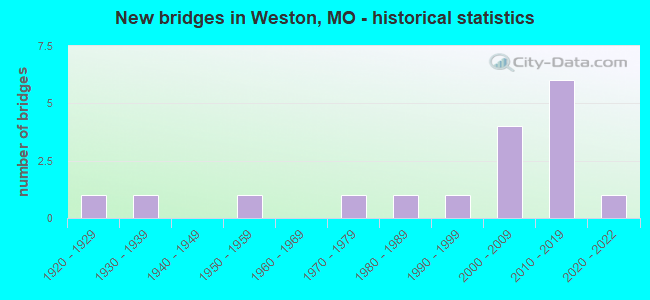
- New bridges - historical statistics
- 11920-1929
- 11930-1939
- 11950-1959
- 11970-1979
- 11980-1989
- 11990-1999
- 42000-2009
- 62010-2019
- 12020-2022
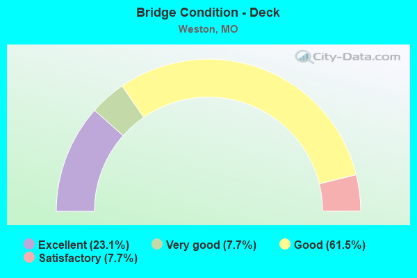
- Bridge Condition - Deck
- 23.1%Excellent
- 7.7%Very good
- 61.5%Good
- 7.7%Satisfactory
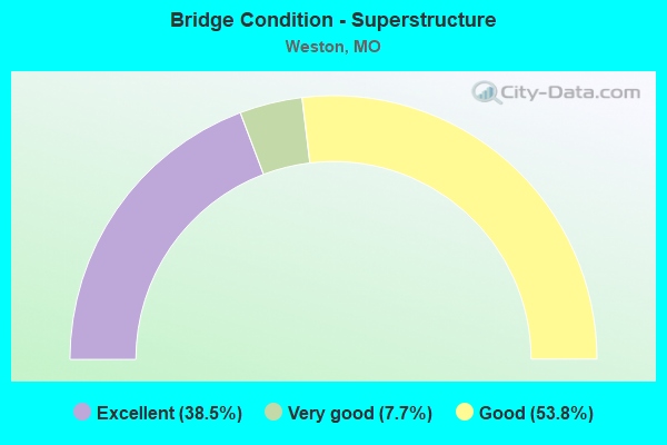
- Bridge Condition - Superstructure
- 38.5%Excellent
- 7.7%Very good
- 53.8%Good
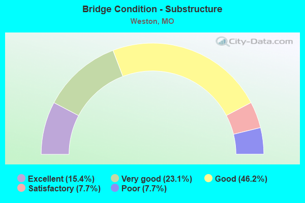
- Bridge Condition - Substructure
- 15.4%Excellent
- 23.1%Very good
- 46.2%Good
- 7.7%Satisfactory
- 7.7%Poor
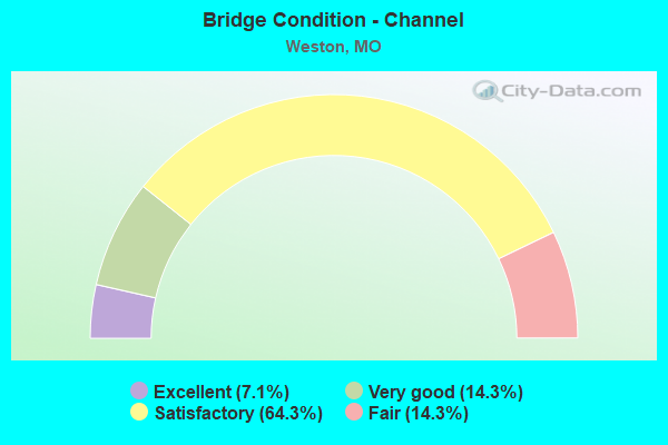
- Bridge Condition - Channel
- 7.1%Excellent
- 14.3%Very good
- 64.3%Satisfactory
- 14.3%Fair
Find on map >> Show street view
Structure Number: 17523, Location: S 3 T 53 N R 36 W (Lat: 39.428194, Lng: -94.922989), Route carried "on" structure: County highway 155, Year Built: 1925, Status: Open, Structure Length: 0.67m (2.20ft), Average Daily Traffic: 120 (year 2020), Truck Traffic: 10%, Average Future Daily Traffic: 222 (year 2040), Features Intersected: BR OF BEAR CR, Facility Carried by Structure: N BLUFF RD
Minimum Vertical Clearance: 30+ m (98+ ft), Kilometerpoint: 0.966, Lanes on structure: 2, Owner: County Highway Agency, Approaching Roadway Width: 5.2m (17.1ft), Material/Design: Concrete, Design/Construction: Culvert, Number Of Spans In Main Unit: 2, Length of Maximum Span: 3.4m (11.2ft), Curb-To-Curb Width: 5.5m (18.0ft), Out-to-Out Width: 6.0m (19.7ft)
Condition: Channel: Satisfactory, Culverts: Satisfactory, Operating Rating: 49.5 metric tons, Method Used To Determine Operating Rating: Allowable Stress (AS), Inventory Rating: 16.2 metric tons, Method Used To Determine Inventory Rating: Allowable Stress (AS), Structural Evaluation: Somewhat better than minimum adequacy, Deck Geometry: High priority of corrective action, Waterway Adequacy: Meets minimum limits, Approach Roadway Alignment: Equal to present desirable criteria, Length Of Structure Improvement: 0.13m (0.43ft), Designated Inspection Frequency: Every 24 months, Inspection Date: April 2020, Bridge Improvement Cost: $85,000, Roadway Improvement Cost: $9,000, Total Project Cost: $128,000 ( Estimate for 2022)
Find on map >> Show street view
Structure Number: 17578, Location: S 11 T 53 N R 36 W (Lat: 39.417514, Lng: -94.914608), Route carried "on" structure: County highway 156, Year Built: 1974, Status: Posted for load, Structure Length: 2.77m (9.09ft), Average Daily Traffic: 225 (year 2020), Truck Traffic: 10%, Average Future Daily Traffic: 416 (year 2040), Features Intersected: BR OF BEAR CR, Facility Carried by Structure: KIRKS BOTTOM RD
Minimum Vertical Clearance: 30+ m (98+ ft), Kilometerpoint: 4.667, Lanes on structure: 1, Owner: County Highway Agency, Approaching Roadway Width: 4.9m (16.1ft), Material/Design: Steel continuous, Design/Construction: Stringer/Multi-beam, Number Of Spans In Main Unit: 1, Number Of Approach Spans: 2, Length of Maximum Span: 14.6m (47.9ft), Curb-To-Curb Width: 5.5m (18.0ft), Out-to-Out Width: 5.5m (18.0ft)
Condition: Deck: Satisfactory, Superstructure: Good, Substructure: Poor, Channel: Fair, Operating Rating: 16.2 metric tons, Method Used To Determine Operating Rating: Field evaluation and documented engineering judgment, Inventory Rating: 8.1 metric tons, Method Used To Determine Inventory Rating: Field evaluation and documented engineering judgment, Structural Evaluation: High priority of replacement, Deck Geometry: High priority of corrective action, Waterway Adequacy: Better than present minimum criteria, Approach Roadway Alignment: High priority of corrective action, Bridge Posting: Required (Relationship of Operating Rating to Maximum Legal Load: > 39.9% below), Length Of Structure Improvement: 0.37m (1.21ft), Designated Inspection Frequency: Every 24 months, Inspection Date: April 2020, Bridge Improvement Cost: $269,000, Roadway Improvement Cost: $27,000, Total Project Cost: $403,000 ( Estimate for 2022), Deck Structure Type: Concrete Cast-file-Place, Wearing Surface/Protective System: Wearing Surface: Monolithic Concrete
Find on map >> Show street view
Structure Number: 29439, Location: S 39 T 22 N R 14 W (Lat: 39.371164, Lng: -94.871333), Route carried "on" structure: County highway 160, Year Built: 2001, Status: Open, Structure Length: 4.57m (14.99ft), Average Daily Traffic: 20 (year 2020), Truck Traffic: 10%, Average Future Daily Traffic: 37 (year 2040), Design Load: HS 20, Features Intersected: BEE CR, Facility Carried by Structure: SOUTH BLUFF
Minimum Vertical Clearance: 30+ m (98+ ft), Kilometerpoint: 0.644, Lanes on structure: 1, Owner: County Highway Agency, Approaching Roadway Width: 4.0m (13.1ft), Material/Design: Steel continuous, Design/Construction: Stringer/Multi-beam, Number Of Spans In Main Unit: 1, Number Of Approach Spans: 2, Length of Maximum Span: 22.9m (75.1ft), Curb-To-Curb Width: 3.7m (12.1ft), Out-to-Out Width: 3.8m (12.5ft)
Condition: Deck: Good, Superstructure: Good, Substructure: Good, Channel: Satisfactory, Operating Rating: 81.0 metric tons, Method Used To Determine Operating Rating: Load Factor (LF), Inventory Rating: 48.6 metric tons, Method Used To Determine Inventory Rating: Load Factor (LF), Structural Evaluation: Better than present minimum criteria, Deck Geometry: Meets minimum limits, Waterway Adequacy: Better than present minimum criteria, Approach Roadway Alignment: High priority of corrective action, Length Of Structure Improvement: 0.56m (1.84ft), Designated Inspection Frequency: Every 24 months, Inspection Date: April 2020, Bridge Improvement Cost: $278,000, Roadway Improvement Cost: $28,000, Total Project Cost: $417,000 ( Estimate for 2022), Deck Structure Type: Concrete Cast-file-Place, Wearing Surface/Protective System: Wearing Surface: Monolithic Concrete
Find on map >> Show street view
Structure Number: 30596, Location: S 11 T 53 N R 36 W (Lat: 39.413178, Lng: -94.902303), Route carried "on" structure: County highway 455, Year Built: 2004, Status: Open, Structure Length: 1.81m (5.94ft), Average Daily Traffic: 200 (year 2020), Truck Traffic: 10%, Average Future Daily Traffic: 370 (year 2040), Design Load: HS 20+Mod, Features Intersected: BENNER BR, Facility Carried by Structure: SPRING ST
Minimum Vertical Clearance: 30+ m (98+ ft), Kilometerpoint: 0.000, Lanes on structure: 2, Owner: City or Municipal Highway Agency, Approaching Roadway Width: 5.5m (18.0ft), Material/Design: Prestressed concrete, Design/Construction: Stringer/Multi-beam, Number Of Spans In Main Unit: 1, Length of Maximum Span: 17.4m (57.1ft), Curb-To-Curb Width: 6.7m (22.0ft), Out-to-Out Width: 9.1m (29.9ft)
Condition: Deck: Good, Superstructure: Good, Substructure: Satisfactory, Channel: Satisfactory, Operating Rating: 72.9 metric tons, Method Used To Determine Operating Rating: Load Factor (LF), Inventory Rating: 43.2 metric tons, Method Used To Determine Inventory Rating: Load Factor (LF), Structural Evaluation: Equal to present minimum criteria, Deck Geometry: Meets minimum limits, Waterway Adequacy: Superior to present desirable criteria, Approach Roadway Alignment: Equal to present desirable criteria, Designated Inspection Frequency: Every 24 months, Inspection Date: April 2020
Find on map >> Show street view
Structure Number: 32543, Location: S 11 T 53 N R 36 W (Lat: 39.411969, Lng: -94.903375), Route carried "on" structure: City street , Year Built: 2008, Status: Open, Structure Length: 1.55m (5.09ft), Average Daily Traffic: 350 (year 2020), Truck Traffic: 10%, Average Future Daily Traffic: 648 (year 2040), Design Load: HS 20+Mod, Features Intersected: MILL CR, Facility Carried by Structure: THOMAS ST
Minimum Vertical Clearance: 30+ m (98+ ft), Kilometerpoint: 0.000, Lanes on structure: 2, Owner: City or Municipal Highway Agency, Approaching Roadway Width: 8.8m (28.9ft), Skew: 2 degrees, Material/Design: Steel, Design/Construction: Stringer/Multi-beam, Number Of Spans In Main Unit: 1, Length of Maximum Span: 14.7m (48.2ft), Curb or Sidewalk Widths: Left: 1.5m (4.9ft), Right: 1.5m (4.9ft), Curb-To-Curb Width: 8.5m (27.9ft), Out-to-Out Width: 12.2m (40.0ft)
Condition: Deck: Good, Superstructure: Good, Substructure: Very good, Channel: Satisfactory, Inventory Rating: 63.9 metric tons, Method Used To Determine Inventory Rating: Load Factor (LF), Structural Evaluation: Better than present minimum criteria, Deck Geometry: Equal to present minimum criteria, Waterway Adequacy: Superior to present desirable criteria, Approach Roadway Alignment: Equal to present desirable criteria, Designated Inspection Frequency: Every 24 months, Inspection Date: April 2020, Deck Structure Type: Concrete Precast Panels, Wearing Surface/Protective System: Wearing Surface: Monolithic Concrete
Find on map >> Show street view
Structure Number: 32797, Location: S 3 T 53 N R 36 W (Lat: 39.437119, Lng: -94.931875), Route carried "on" structure: State highway 45, Year Built: 2009, Status: Open, Structure Length: 5.18m (16.99ft), Average Daily Traffic: 4,052 (year 2021), Truck Traffic: 12%, Average Future Daily Traffic: 7,699 (year 2041), Design Load: HS 20+Mod, Features Intersected: BEAR CR
Minimum Vertical Clearance: 30+ m (98+ ft), Kilometerpoint: 17.062, Lanes on structure: 2, Base Highway Network: Yes, Owner: State Highway Agency, Approaching Roadway Width: 9.8m (32.2ft), Skew: 5 degrees, Material/Design: Prestressed concrete, Design/Construction: Box Beam or Girders - Single/Spread, Number Of Spans In Main Unit: 3, Length of Maximum Span: 18.3m (60.0ft), Curb-To-Curb Width: 9.8m (32.2ft), Out-to-Out Width: 10.4m (34.1ft)
Condition: Deck: Good, Superstructure: Very good, Substructure: Good, Channel: Satisfactory, Operating Rating: 77.4 metric tons, Method Used To Determine Operating Rating: Load Factor (LF), Inventory Rating: 42.3 metric tons, Method Used To Determine Inventory Rating: Load Factor (LF), Structural Evaluation: Better than present minimum criteria, Deck Geometry: Meets minimum limits, Waterway Adequacy: Superior to present desirable criteria, Approach Roadway Alignment: Equal to present desirable criteria, Designated Inspection Frequency: Every 24 months, Inspection Date: October 2020, Deck Structure Type: Concrete Cast-file-Place, Wearing Surface/Protective System: Wearing Surface: Monolithic Concrete, Deck Protection: Epoxy Coated Reinforcing
Find on map >> Show street view
Structure Number: 32893, Location: S 33 T 54 N R 36 W (Lat: 39.438906, Lng: -94.941739), Route carried "on" structure: State highway 45, Year Built: 2010, Status: Open, Structure Length: 10.82m (35.50ft), Average Daily Traffic: 4,052 (year 2021), Truck Traffic: 12%, Average Future Daily Traffic: 7,699 (year 2041), Features Intersected: BNSF RR
Minimum Vertical Clearance: 30+ m (98+ ft), Kilometerpoint: 16.193, Lanes on structure: 2, Base Highway Network: Yes, Owner: State Highway Agency, Approaching Roadway Width: 12.2m (40.0ft), Skew: 5 degrees, Material/Design: Prestressed concrete continuous, Design/Construction: Tee Beam, Number Of Spans In Main Unit: 3, Length of Maximum Span: 41.5m (136.2ft), Curb-To-Curb Width: 9.8m (32.2ft), Out-to-Out Width: 10.6m (34.8ft)
Condition: Deck: Good, Superstructure: Excellent, Substructure: Good, Operating Rating: 55.8 metric tons, Method Used To Determine Operating Rating: Load Factor (LF), Inventory Rating: 33.3 metric tons, Method Used To Determine Inventory Rating: Load Factor (LF), Structural Evaluation: Better than present minimum criteria, Deck Geometry: Meets minimum limits, Underclear: Equal to present minimum criteria, Approach Roadway Alignment: Equal to present desirable criteria, Designated Inspection Frequency: Every 24 months, Inspection Date: October 2020, Deck Structure Type: Concrete Precast Panels, Wearing Surface/Protective System: Wearing Surface: Monolithic Concrete, Deck Protection: Epoxy Coated Reinforcing
Find on map >> Show street view
Structure Number: 33862, Location: S 34 T 54 N R 36 W (Lat: 39.450617, Lng: -94.930250), Route carried "on" structure: County highway 21, Year Built: 2011, Status: Open, Structure Length: 2.82m (9.25ft), Average Daily Traffic: 225 (year 2020), Truck Traffic: 10%, Average Future Daily Traffic: 416 (year 2040), Design Load: HS 20, Features Intersected: BR OF BEAR CR, Facility Carried by Structure: S DYE STORE RD
Minimum Vertical Clearance: 30+ m (98+ ft), Kilometerpoint: 3.058, Lanes on structure: 2, Owner: County Highway Agency, Approaching Roadway Width: 7.3m (24.0ft), Material/Design: Prestressed concrete, Design/Construction: Tee Beam, Number Of Spans In Main Unit: 1, Length of Maximum Span: 27.4m (89.9ft), Curb-To-Curb Width: 7.3m (24.0ft), Out-to-Out Width: 7.5m (24.6ft)
Condition: Deck: Very good, Superstructure: Excellent, Substructure: Very good, Channel: Very good, Operating Rating: 77.4 metric tons, Method Used To Determine Operating Rating: Load Factor (LF), Inventory Rating: 45.9 metric tons, Method Used To Determine Inventory Rating: Load Factor (LF), Structural Evaluation: Equal to present desirable criteria, Deck Geometry: Somewhat better than minimum adequacy, Waterway Adequacy: Superior to present desirable criteria, Approach Roadway Alignment: Equal to present desirable criteria, Designated Inspection Frequency: Every 24 months, Inspection Date: April 2020, Deck Structure Type: Concrete Precast Panels, Wearing Surface/Protective System: Wearing Surface: Monolithic Concrete, Deck Protection: Epoxy Coated Reinforcing
Find on map >> Show street view
Structure Number: 34401, Location: S 31 T 53 N R 35 W (Lat: 39.365250, Lng: -94.871486), Route carried "on" structure: State highway 92, Year Built: 2013, Status: Open, Structure Length: 22.34m (73.29ft), Average Daily Traffic: 10,974 (year 2021), Truck Traffic: 9%, Average Future Daily Traffic: 22,497 (year 2041), Features Intersected: MO 45, BNSF
Minimum Vertical Clearance: 30+ m (98+ ft), Kilometerpoint: 5.749, Lanes on structure: 2, Lanes under structure: 2, Base Highway Network: Yes, Owner: State Highway Agency, Approaching Roadway Width: 9.8m (32.2ft), Skew: 8 degrees, Material/Design: Prestressed concrete continuous, Design/Construction: Tee Beam, Number Of Spans In Main Unit: 9, Length of Maximum Span: 27.4m (89.9ft), Curb-To-Curb Width: 9.8m (32.2ft), Out-to-Out Width: 10.6m (34.8ft)
Condition: Deck: Good, Superstructure: Excellent, Substructure: Excellent, Operating Rating: 72.0 metric tons, Method Used To Determine Operating Rating: Load Factor (LF), Inventory Rating: 43.2 metric tons, Method Used To Determine Inventory Rating: Load Factor (LF), Structural Evaluation: Superior to present desirable criteria, Deck Geometry: Meets minimum limits, Underclear: Equal to present minimum criteria, Approach Roadway Alignment: Equal to present desirable criteria, Designated Inspection Frequency: Every 24 months, Inspection Date: October 2020, Deck Structure Type: Concrete Cast-file-Place, Wearing Surface/Protective System: Wearing Surface: Monolithic Concrete, Deck Protection: Epoxy Coated Reinforcing
Find on map >> Show street view
Structure Number: 3443, Location: S 21 T 53 N R 35 W (Lat: 39.388922, Lng: -94.838964), Route carried "on" structure: State highway 273, Year Built: 1985, Status: Open, Structure Length: 6.92m (22.70ft), Average Daily Traffic: 5,491 (year 2021), Truck Traffic: 5%, Average Future Daily Traffic: 10,433 (year 2041), Design Load: HS 20, Features Intersected: BEE CR
Minimum Vertical Clearance: 30+ m (98+ ft), Kilometerpoint: 32.990, Lanes on structure: 2, Base Highway Network: Yes, Owner: State Highway Agency, Approaching Roadway Width: 10.4m (34.1ft), Skew: 2 degrees, Material/Design: Prestressed concrete continuous, Design/Construction: Stringer/Multi-beam, Number Of Spans In Main Unit: 3, Length of Maximum Span: 23.1m (75.8ft), Curb or Sidewalk Widths: Left: 0.2m (0.7ft), Right: 0.2m (0.7ft), Curb-To-Curb Width: 10.0m (32.8ft), Out-to-Out Width: 10.8m (35.4ft)
Condition: Deck: Good, Superstructure: Good, Substructure: Good, Channel: Satisfactory, Operating Rating: 79.2 metric tons, Method Used To Determine Operating Rating: Load Factor (LF), Inventory Rating: 40.5 metric tons, Method Used To Determine Inventory Rating: Load Factor (LF), Structural Evaluation: Better than present minimum criteria, Deck Geometry: Meets minimum limits, Waterway Adequacy: Equal to present desirable criteria, Approach Roadway Alignment: Equal to present desirable criteria, Designated Inspection Frequency: Every 24 months, Inspection Date: October 2020, Deck Structure Type: Concrete Cast-file-Place, Wearing Surface/Protective System: Wearing Surface: Monolithic Concrete, Deck Protection: Epoxy Coated Reinforcing
Find on map >> Show street view
Structure Number: 34498, Location: S 22 T 54 N R 36 W (Lat: 39.474444, Lng: -94.927222), Route carried "on" structure: County highway 24, Year Built: 2014, Status: Open, Structure Length: 1.47m (4.82ft), Average Daily Traffic: 110 (year 2020), Truck Traffic: 10%, Average Future Daily Traffic: 204 (year 2040), Design Load: HS 20, Features Intersected: BEAR CR, Facility Carried by Structure: DYE STORE RD
Minimum Vertical Clearance: 30+ m (98+ ft), Kilometerpoint: 0.322, Lanes on structure: 2, Owner: County Highway Agency, Approaching Roadway Width: 7.3m (24.0ft), Material/Design: Steel, Design/Construction: Stringer/Multi-beam, Number Of Spans In Main Unit: 1, Length of Maximum Span: 14.3m (46.9ft), Curb-To-Curb Width: 7.3m (24.0ft), Out-to-Out Width: 8.2m (26.9ft)
Condition: Deck: Excellent, Superstructure: Good, Substructure: Good, Channel: Satisfactory, Inventory Rating: 61.2 metric tons, Method Used To Determine Inventory Rating: Load Factor (LF), Structural Evaluation: Better than present minimum criteria, Deck Geometry: Somewhat better than minimum adequacy, Waterway Adequacy: Equal to present desirable criteria, Approach Roadway Alignment: Equal to present desirable criteria, Designated Inspection Frequency: Every 24 months, Inspection Date: April 2020, Deck Structure Type: Concrete Precast Panels, Wearing Surface/Protective System: Wearing Surface: Monolithic Concrete, Deck Protection: Epoxy Coated Reinforcing
Find on map >> Show street view
Structure Number: 35839, Location: S 34 T 54 N R 36 W (Lat: 39.446389, Lng: -94.929528), Route carried "on" structure: County highway 20, Year Built: 2018, Status: Open, Structure Length: 2.93m (9.61ft), Average Daily Traffic: 30 (year 2020), Truck Traffic: 10%, Average Future Daily Traffic: 56 (year 2040), Design Load: HS 20, Features Intersected: BEAR CR, Facility Carried by Structure: COUNTRYSIDE ROAD
Minimum Vertical Clearance: 30+ m (98+ ft), Kilometerpoint: 0.000, Lanes on structure: 2, Owner: Local Agency, Maintenance Responsibility: Town or Township Highway Agency, Approaching Roadway Width: 6.1m (20.0ft), Skew: 1 degrees, Material/Design: Steel, Design/Construction: Stringer/Multi-beam, Number Of Spans In Main Unit: 1, Length of Maximum Span: 28.7m (94.2ft), Curb-To-Curb Width: 7.3m (24.0ft), Out-to-Out Width: 7.5m (24.6ft)
Condition: Deck: Excellent, Superstructure: Excellent, Substructure: Very good, Channel: Very good, Operating Rating: 66.6 metric tons, Method Used To Determine Operating Rating: Load Factor (LF), Inventory Rating: 40.5 metric tons, Method Used To Determine Inventory Rating: Load Factor (LF), Structural Evaluation: Equal to present desirable criteria, Deck Geometry: Equal to present minimum criteria, Waterway Adequacy: Superior to present desirable criteria, Approach Roadway Alignment: Equal to present minimum criteria, Designated Inspection Frequency: Every 24 months, Inspection Date: April 2020, Deck Structure Type: Concrete Cast-file-Place, Wearing Surface/Protective System: Wearing Surface: Monolithic Concrete
Find on map >> Show street view
Structure Number: 3638, Location: S 30 T 53 N R 35 W (Lat: 39.381506, Lng: -94.864633), Route carried "on" structure: State highway 45, Year Built: 1992, Status: Open, Structure Length: 8.66m (28.41ft), Average Daily Traffic: 6,554 (year 2021), Truck Traffic: 13%, Average Future Daily Traffic: 12,453 (year 2041), Design Load: HS 20, Features Intersected: BEE CR
Minimum Vertical Clearance: 30+ m (98+ ft), Kilometerpoint: 26.738, Lanes on structure: 2, Base Highway Network: Yes, Owner: State Highway Agency, Approaching Roadway Width: 8.5m (27.9ft), Skew: 4 degrees, Material/Design: Prestressed concrete continuous, Design/Construction: Stringer/Multi-beam, Number Of Spans In Main Unit: 4, Length of Maximum Span: 26.9m (88.3ft), Curb or Sidewalk Widths: Left: 0.2m (0.7ft), Right: 0.2m (0.7ft), Curb-To-Curb Width: 11.8m (38.7ft), Out-to-Out Width: 12.6m (41.3ft)
Condition: Deck: Good, Superstructure: Good, Substructure: Good, Channel: Satisfactory, Operating Rating: 75.6 metric tons, Method Used To Determine Operating Rating: Load Factor (LF), Inventory Rating: 36.9 metric tons, Method Used To Determine Inventory Rating: Load Factor (LF), Structural Evaluation: Better than present minimum criteria, Deck Geometry: Somewhat better than minimum adequacy, Waterway Adequacy: Superior to present desirable criteria, Approach Roadway Alignment: Equal to present desirable criteria, Designated Inspection Frequency: Every 24 months, Inspection Date: October 2020, Deck Structure Type: Concrete Cast-file-Place, Wearing Surface/Protective System: Wearing Surface: Epoxy Overlay, Deck Protection: Epoxy Coated Reinforcing
Find on map >> Show street view
Structure Number: 36595, Location: S 11 T 53 N R 36 W (Lat: 39.417531, Lng: -94.914700), Route carried "on" structure: County highway 156, Year Built: 2021, Status: Not yet open, Structure Length: 3.23m (10.60ft), Average Daily Traffic: 225 (year 2021), Truck Traffic: 10%, Average Future Daily Traffic: 416 (year 2041), Design Load: HS 20, Features Intersected: BR OF BEAR CR, Facility Carried by Structure: HARPST RD
Minimum Vertical Clearance: 30+ m (98+ ft), Kilometerpoint: 4.667, Lanes on structure: 2, Owner: County Highway Agency, Approaching Roadway Width: 6.1m (20.0ft), Skew: 3 degrees, Material/Design: Prestressed concrete, Design/Construction: Tee Beam, Number Of Spans In Main Unit: 1, Length of Maximum Span: 31.1m (102.0ft), Curb-To-Curb Width: 7.3m (24.0ft), Out-to-Out Width: 7.4m (24.3ft)
Condition: Deck: Excellent, Superstructure: Excellent, Substructure: Excellent, Channel: Excellent, Operating Rating: 69.3 metric tons, Method Used To Determine Operating Rating: Load Factor (LF), Inventory Rating: 54.0 metric tons, Method Used To Determine Inventory Rating: Load Factor (LF), Structural Evaluation: Superior to present desirable criteria, Deck Geometry: Somewhat better than minimum adequacy, Waterway Adequacy: Equal to present minimum criteria, Approach Roadway Alignment: Equal to present desirable criteria, Designated Inspection Frequency: Every 24 months, Inspection Date: Febuary 2021, Deck Structure Type: Concrete Precast Panels, Wearing Surface/Protective System: Wearing Surface: Monolithic Concrete, Deck Protection: Epoxy Coated Reinforcing
Find on map >> Show street view
Structure Number: 5431, Location: S 12 T 53 N R 36 W (Lat: 39.420150, Lng: -94.894011), Route carried "on" structure: State highway 45, Year Built: 1936, Status: Open, Structure Length: 0.98m (3.22ft), Average Daily Traffic: 12,832 (year 2021), Truck Traffic: 13%, Average Future Daily Traffic: 24,381 (year 2041), Design Load: H 15, Features Intersected: PEDEE CR
Minimum Vertical Clearance: 30+ m (98+ ft), Kilometerpoint: 21.058, Lanes on structure: 2, Base Highway Network: Yes, Owner: State Highway Agency, Approaching Roadway Width: 9.1m (29.9ft), Material/Design: Concrete continuous, Design/Construction: Culvert, Number Of Spans In Main Unit: 3, Length of Maximum Span: 3.0m (9.8ft)
Condition: Channel: Fair, Culverts: Satisfactory, Operating Rating: 36.0 metric tons, Method Used To Determine Operating Rating: Field evaluation and documented engineering judgment, Inventory Rating: 21.6 metric tons, Method Used To Determine Inventory Rating: Field evaluation and documented engineering judgment, Structural Evaluation: Somewhat better than minimum adequacy, Waterway Adequacy: Equal to present minimum criteria, Approach Roadway Alignment: Equal to present desirable criteria, Designated Inspection Frequency: Every 24 months, Inspection Date: December 2020
Find on map >> Show street view
Structure Number: 7868, Location: S 32 T 54 N R 35 W (Lat: 39.453003, Lng: -94.850300), Route carried "on" structure: State highway P, Year Built: 1955, Status: Open, Structure Length: 0.80m (2.62ft), Average Daily Traffic: 1,251 (year 2021), Truck Traffic: 4%, Average Future Daily Traffic: 2,252 (year 2041), Design Load: H 10, Features Intersected: HARDESTY BR
Minimum Vertical Clearance: 30+ m (98+ ft), Kilometerpoint: 5.129, Lanes on structure: 2, Owner: State Highway Agency, Approaching Roadway Width: 7.3m (24.0ft), Skew: 2 degrees, Material/Design: Concrete continuous, Design/Construction: Culvert, Number Of Spans In Main Unit: 2, Length of Maximum Span: 3.7m (12.1ft), Curb-To-Curb Width: 12.9m (42.3ft), Out-to-Out Width: 13.5m (44.3ft)
Condition: Channel: Satisfactory, Culverts: Satisfactory, Operating Rating: 36.0 metric tons, Method Used To Determine Operating Rating: Field evaluation and documented engineering judgment, Inventory Rating: 21.6 metric tons, Method Used To Determine Inventory Rating: Field evaluation and documented engineering judgment, Structural Evaluation: Somewhat better than minimum adequacy, Deck Geometry: Better than present minimum criteria, Waterway Adequacy: Equal to present minimum criteria, Approach Roadway Alignment: Equal to present desirable criteria, Designated Inspection Frequency: Every 24 months, Inspection Date: December 2020
Find on map >> Show street view
Structure Number: 34401, Location: S 31 T 53 N R 35 W (Lat: 39.365250, Lng: -94.871486), Route carried "under" structure: State highway 45, Year Built: 2013, Structure Length: 0. m, Average Daily Traffic: 4,211 (year 2021), Truck Traffic: 13%, Features Intersected: MO 45, Facility Carried by Structure: MO 92 E
Minimum Vertical Clearance: 5.31m (17.42ft), Kilometerpoint: 28.746, Lanes on structure: 2, Lanes under structure: 2, Material/Design: Prestressed concrete continuous, Design/Construction: Tee Beam, Length of Maximum Span: 27.4m (89.9ft)