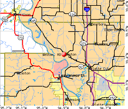
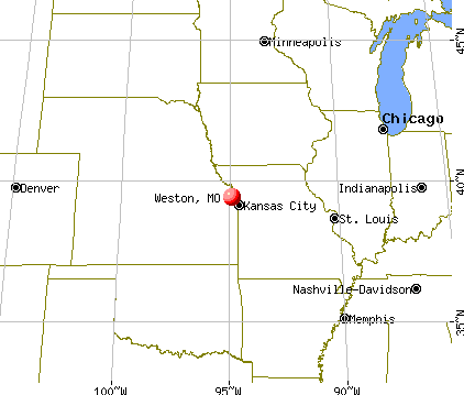
Weston, Missouri

Weston: Weston Brewing Company

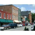
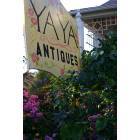
Weston: Downtown Weston, MO
Weston: Downtown Weston, MO
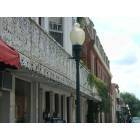
Weston: Historic Downtown
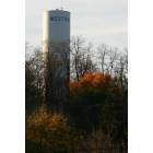
Weston: Weston Water Tower

Weston: Downtown Weston, MO
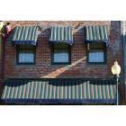
Weston: Downtown Balcony
Weston: Downtown Weston, MO
- add
your
Submit your own pictures of this city and show them to the world
- OSM Map
- General Map
- Google Map
- MSN Map
Population change since 2000: +9.6%
 |
| Males: 857 | |
| Females: 930 |
| Median resident age: | 42.7 years |
| Missouri median age: | 39.1 years |
Zip codes: 64098.
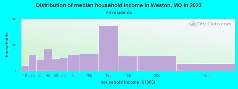
| Weston: | $82,020 |
| MO: | $64,811 |
Estimated per capita income in 2022: $35,172 (it was $20,794 in 2000)
Weston city income, earnings, and wages data
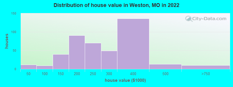
Estimated median house or condo value in 2022: $251,513 (it was $97,500 in 2000)
| Weston: | $251,513 |
| MO: | $221,200 |
Mean prices in 2022: all housing units: $208,367; detached houses: $208,412; townhouses or other attached units: $168,736
Median gross rent in 2022: $930.
Detailed information about poverty and poor residents in Weston, MO

Compare current foreclosures near Weston, MO:
| Photo | Address | Area | Beds / Baths | Price | Details |
|---|---|---|---|---|---|

|
#1
County Road P
Weston, MO 64098
|
- sq. feet
|
- baths - beds |
show details | |

|
#2
Citadel Dr
Weston, MO 64098
|
- sq. feet
|
- baths - beds |
show details | |

|
#3
Pottawatomie St
Leavenworth, KS 66048
|
2,651 sq. feet
|
2 baths 5 beds |
show details | |

|
#4
Wolcott Rd
Leavenworth, KS 66048
|
648 sq. feet
|
1 baths 3 beds |
show details | |

|
#5
NW 130th St
Platte City, MO 64079
|
1,960 sq. feet
|
3 baths 3 beds |
show details | |

|
#6
S 16th St
Leavenworth, KS 66048
|
1,682 sq. feet
|
3 baths 3 beds |
show details | |

|
#7
N 3rd St
Lansing, KS 66043
|
1,216 sq. feet
|
2 baths 3 beds |
show details | |

|
#8
Bittersweet Ln
Lansing, KS 66043
|
1,422 sq. feet
|
2 baths 3 beds |
show details | |

|
#9
Fairlane St
Lansing, KS 66043
|
925 sq. feet
|
1 baths 3 beds |
show details | |

|
#10
Willow Ct
Lansing, KS 66043
|
1,589 sq. feet
|
2 baths 3 beds |
show details |
| Photo | Address | Area | Beds / Baths | Price | Details |
|---|---|---|---|---|---|

|
#11
Springdale Rd
Leavenworth, KS 66048
|
1,633 sq. feet
|
2 baths 3 beds |
show details | |

|
#12
Timber Creek Cir
Lansing, KS 66043
|
1,894 sq. feet
|
2 baths 3 beds |
show details | |

|
#13
Marion St
Leavenworth, KS 66048
|
1,323 sq. feet
|
2 baths 3 beds |
show details | |

|
#14
Broadway Ter
Leavenworth, KS 66048
|
2,378 sq. feet
|
3 baths 4 beds |
show details | |

|
#15
N 8th St
Lansing, KS 66043
|
1,764 sq. feet
|
1 baths 3 beds |
show details | |

|
#16
S 14th St
Leavenworth, KS 66048
|
1,776 sq. feet
|
3 baths 3 beds |
show details | |

|
#17
Broadway Ter
Leavenworth, KS 66048
|
2,315 sq. feet
|
3 baths 4 beds |
show details | |

|
#18
Carriage Crossing Rd
Lansing, KS 66043
|
2,016 sq. feet
|
2 baths 4 beds |
show details | |

|
#19
Folsom St
Leavenworth, KS 66048
|
1,862 sq. feet
|
2 baths 3 beds |
show details | |

|
#20
Timber Park Dr
Platte City, MO 64079
|
- sq. feet
|
2 baths 3 beds |
show details |
| Photo | Address | Area | Beds / Baths | Price | Details |
|---|---|---|---|---|---|

|
#21
Francis Ave
Leavenworth, KS 66048
|
2,512 sq. feet
|
3 baths 4 beds |
show details | |

|
#22
Limit St
Leavenworth, KS 66048
|
3,026 sq. feet
|
2 baths 4 beds |
show details | |

|
#23
Lakeview Cir
Leavenworth, KS 66048
|
2,215 sq. feet
|
2 baths 3 beds |
show details | |

|
#24
Bittersweet Ln
Lansing, KS 66043
|
3,574 sq. feet
|
3 baths 5 beds |
show details | |

|
#25
Oakbrook Dr
Lansing, KS 66043
|
1,972 sq. feet
|
2 baths 3 beds |
show details | |

|
#26
Parallel St
Atchison, KS 66002
|
1,929 sq. feet
|
1 baths 4 beds |
show details | |

|
#27
W Summit St
Smithville, MO 64089
|
1,449 sq. feet
|
2 baths 3 beds |
show details | |

|
#28
N 97th St
Kansas City, KS 66109
|
1,120 sq. feet
|
1 baths 3 beds |
show details | |

|
#29
Atchison St
Atchison, KS 66002
|
1,456 sq. feet
|
1 baths 3 beds |
show details | |

|
#30
Mound Dr
Atchison, KS 66002
|
896 sq. feet
|
1 baths 3 beds |
show details |
| Photo | Address | Area | Beds / Baths | Price | Details |
|---|---|---|---|---|---|

|
#31
Pine St
Atchison, KS 66002
|
1,740 sq. feet
|
3 baths 4 beds |
show details | |

|
#32
N 11th St
Atchison, KS 66002
|
910 sq. feet
|
1 baths 2 beds |
show details | |

|
#33
N St
Atchison, KS 66002
|
1,534 sq. feet
|
3 baths 3 beds |
show details | |

|
#34
Mound St
Atchison, KS 66002
|
1,040 sq. feet
|
1 baths 2 beds |
show details | |

|
#35
Santa Fe St
Atchison, KS 66002
|
1,923 sq. feet
|
2 baths 2 beds |
show details | |

|
#36
Westwood Dr
Leavenworth, KS 66048
|
2,374 sq. feet
|
3 baths 3 beds |
show details | |

|
#37
Polfer Rd
Kansas City, KS 66109
|
1,342 sq. feet
|
2 baths 3 beds |
show details | |

|
#38
Spring Garden St
Atchison, KS 66002
|
1,242 sq. feet
|
1 baths 3 beds |
show details | |

|
#39
Park St
Atchison, KS 66002
|
1,199 sq. feet
|
1 baths 2 beds |
show details | |

|
#40
S 7th St
Atchison, KS 66002
|
2,304 sq. feet
|
2 baths 3 beds |
show details |
| Photo | Address | Area | Beds / Baths | Price | Details |
|---|---|---|---|---|---|

|
#41
S 5th St
Atchison, KS 66002
|
1,886 sq. feet
|
2 baths 3 beds |
show details | |

|
#42
S 7th St
Atchison, KS 66002
|
1,110 sq. feet
|
1 baths 3 beds |
show details | |

|
#43
Canyon View Dr
Lansing, KS 66043
|
2,453 sq. feet
|
2 baths 3 beds |
show details | |

|
#44
Central St
Leavenworth, KS 66048
|
1,254 sq. feet
|
2 baths 3 beds |
show details | |

|
#45
W Kay St
Lansing, KS 66043
|
1,152 sq. feet
|
1 baths 3 beds |
show details | |

|
#46
Evergreen St
Leavenworth, KS 66048
|
1,629 sq. feet
|
2 baths 4 beds |
show details | |

|
#47
N 123rd Ter
Kansas City, KS 66109
|
1,820 sq. feet
|
2 baths 3 beds |
show details | |

|
#48
Osage St
Leavenworth, KS 66048
|
1,072 sq. feet
|
1 baths 3 beds |
show details | |

|
#49
Delaware St
Leavenworth, KS 66048
|
744 sq. feet
|
1 baths 2 beds |
show details | |

|
Check over 1 million property listings on Foreclosure.com!
|
browse all offers | |||


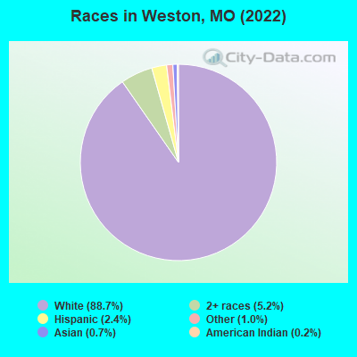
- 1,59788.7%White alone
- 935.2%Two or more races
- 432.4%Hispanic
- 181.0%Other race alone
- 130.7%Asian alone
- 30.2%American Indian alone
Races in Weston detailed stats: ancestries, foreign born residents, place of birth
According to our research of Missouri and other state lists, there were 5 registered sex offenders living in Weston, Missouri as of April 27, 2024.
The ratio of all residents to sex offenders in Weston is 304 to 1.
The ratio of registered sex offenders to all residents in this city is near the state average.
Type |
2009 |
2010 |
2011 |
2012 |
2013 |
2014 |
2015 |
2016 |
2017 |
2018 |
2019 |
2020 |
2021 |
2022 |
|---|---|---|---|---|---|---|---|---|---|---|---|---|---|---|
| Murders (per 100,000) | 0 (0.0) | 0 (0.0) | 0 (0.0) | 0 (0.0) | 0 (0.0) | 0 (0.0) | 0 (0.0) | 0 (0.0) | 0 (0.0) | 0 (0.0) | 0 (0.0) | 0 (0.0) | 1 (53.9) | 0 (0.0) |
| Rapes (per 100,000) | 1 (60.0) | 0 (0.0) | 1 (60.7) | 0 (0.0) | 1 (58.7) | 0 (0.0) | 0 (0.0) | 1 (57.5) | 1 (56.5) | 0 (0.0) | 0 (0.0) | 1 (54.5) | 1 (53.9) | 1 (56.4) |
| Robberies (per 100,000) | 0 (0.0) | 0 (0.0) | 0 (0.0) | 0 (0.0) | 0 (0.0) | 1 (58.2) | 0 (0.0) | 0 (0.0) | 0 (0.0) | 0 (0.0) | 0 (0.0) | 0 (0.0) | 1 (53.9) | 1 (56.4) |
| Assaults (per 100,000) | 0 (0.0) | 6 (365.6) | 3 (182.1) | 5 (298.9) | 2 (117.4) | 1 (58.2) | 4 (231.1) | 1 (57.5) | 2 (112.9) | 3 (166.3) | 0 (0.0) | 1 (54.5) | 0 (0.0) | 2 (112.9) |
| Burglaries (per 100,000) | 21 (1,261) | 8 (487.5) | 2 (121.4) | 7 (418.4) | 6 (352.1) | 2 (116.5) | 1 (57.8) | 9 (517.5) | 0 (0.0) | 4 (221.7) | 4 (218.7) | 2 (109.1) | 6 (323.6) | 1 (56.4) |
| Thefts (per 100,000) | 26 (1,561) | 13 (792.2) | 14 (850.0) | 20 (1,195) | 21 (1,232) | 8 (465.9) | 8 (462.2) | 18 (1,035) | 18 (1,016) | 12 (665.2) | 10 (546.7) | 7 (381.7) | 28 (1,510) | 16 (902.9) |
| Auto thefts (per 100,000) | 1 (60.0) | 1 (60.9) | 2 (121.4) | 0 (0.0) | 1 (58.7) | 0 (0.0) | 0 (0.0) | 1 (57.5) | 0 (0.0) | 1 (55.4) | 1 (54.7) | 0 (0.0) | 1 (53.9) | 1 (56.4) |
| Arson (per 100,000) | 0 (0.0) | 0 (0.0) | 0 (0.0) | 0 (0.0) | 0 (0.0) | 0 (0.0) | 0 (0.0) | 0 (0.0) | 0 (0.0) | 0 (0.0) | 0 (0.0) | 0 (0.0) | 1 (53.9) | 0 (0.0) |
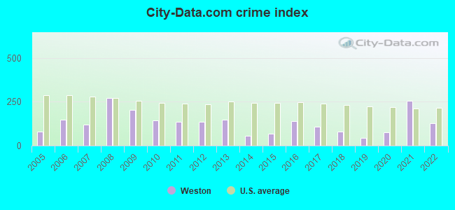
| City-Data.com crime index | 203.5 | 143.8 | 137.2 | 136.9 | 149.1 | 55.9 | 68.7 | 139.7 | 108.4 | 79.8 | 41.6 | 77.4 | 254.6 | 129.2 |
The City-Data.com crime index weighs serious crimes and violent crimes more heavily. Higher means more crime, U.S. average is 246.1. It adjusts for the number of visitors and daily workers commuting into cities.
Crime rate in Weston detailed stats: murders, rapes, robberies, assaults, burglaries, thefts, arson
Full-time law enforcement employees in 2021, including police officers: 9 (9 officers - 8 male; 1 female).
| Officers per 1,000 residents here: | 4.85 |
| Missouri average: | 2.54 |
 Recent articles from our blog. Our writers, many of them Ph.D. graduates or candidates, create easy-to-read articles on a wide variety of topics.

 | Kansas City Missouri Request for Information (7 replies) |
| Family moving to KC from CA. Lee's Summit vs Johnson County? (60 replies) |
| Total outsider want to move to small city in Missouri, where do you suggest? (35 replies) |
| Dreaming next year's trip (12 replies) |
| small towns outside of Kansas City (27 replies) |
| Retirees relocating from Colorado Springs (8 replies) |
Latest news from Weston, MO collected exclusively by city-data.com from local newspapers, TV, and radio stations
Weston, MO City Guides:
Ancestries: German (25.6%), Irish (19.0%), American (11.8%), English (11.0%), European (7.2%), Scottish (2.0%).
Current Local Time: CST time zone
Incorporated in 1842
Elevation: 795 feet
Land area: 1.64 square miles.
Population density: 1,090 people per square mile (low).
38 residents are foreign born (1.2% Europe, 0.7% Asia, 0.3% Latin America).
| This city: | 2.1% |
| Missouri: | 4.2% |
Median real estate property taxes paid for housing units with mortgages in 2022: $2,394 (0.9%)
Median real estate property taxes paid for housing units with no mortgage in 2022: $2,231 (0.9%)
Nearest city with pop. 50,000+: St. Joseph, MO  (24.1 miles , pop. 73,990).
Nearest city with pop. 200,000+: Kansas City, MO (29.7 miles , pop. 441,545).
Nearest city with pop. 1,000,000+: Chicago, IL (414.3 miles , pop. 2,896,016).
Nearest cities:
), ), )Latitude: 39.41 N, Longitude: 94.90 W
Area code: 816

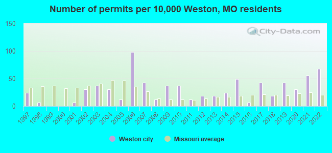
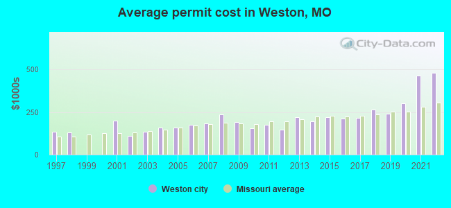
Single-family new house construction building permits:
- 2022: 11 buildings, average cost: $480,000
- 2021: 9 buildings, average cost: $463,900
- 2020: 5 buildings, average cost: $303,400
- 2019: 7 buildings, average cost: $238,300
- 2018: 3 buildings, average cost: $263,300
- 2017: 7 buildings, average cost: $215,900
- 2016: 1 building, cost: $210,000
- 2015: 8 buildings, average cost: $220,300
- 2014: 4 buildings, average cost: $193,800
- 2013: 3 buildings, average cost: $220,000
- 2012: 3 buildings, average cost: $147,000
- 2011: 2 buildings, average cost: $175,000
- 2010: 6 buildings, average cost: $153,200
- 2009: 6 buildings, average cost: $190,000
- 2008: 2 buildings, average cost: $235,000
- 2007: 7 buildings, average cost: $185,000
- 2006: 16 buildings, average cost: $174,100
- 2005: 2 buildings, average cost: $158,200
- 2004: 5 buildings, average cost: $158,200
- 2003: 6 buildings, average cost: $135,300
- 2002: 5 buildings, average cost: $111,000
- 2001: 1 building, cost: $200,000
- 1998: 1 building, cost: $130,000
- 1997: 4 buildings, average cost: $134,300
| Here: | 2.4% |
| Missouri: | 2.8% |
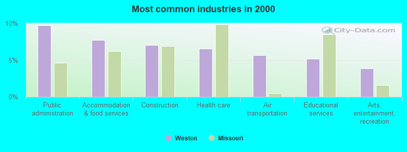
- Public administration (9.8%)
- Accommodation & food services (7.8%)
- Construction (7.1%)
- Health care (6.6%)
- Air transportation (5.6%)
- Educational services (5.2%)
- Arts, entertainment, recreation (3.9%)
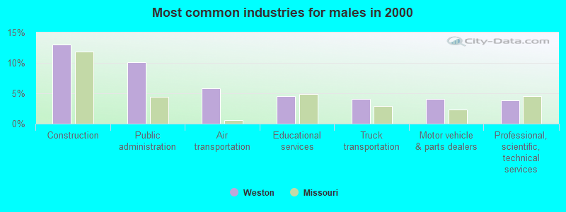
- Construction (13.0%)
- Public administration (10.1%)
- Air transportation (5.8%)
- Educational services (4.5%)
- Truck transportation (4.0%)
- Motor vehicle & parts dealers (4.0%)
- Professional, scientific, technical services (3.8%)
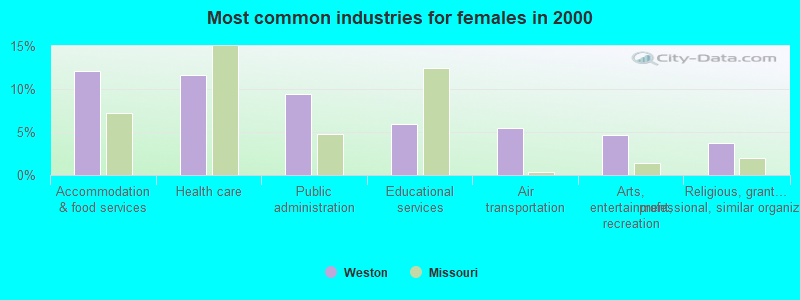
- Accommodation & food services (12.1%)
- Health care (11.6%)
- Public administration (9.4%)
- Educational services (5.9%)
- Air transportation (5.4%)
- Arts, entertainment, recreation (4.7%)
- Religious, grantmaking, civic, professional, similar organizations (3.7%)
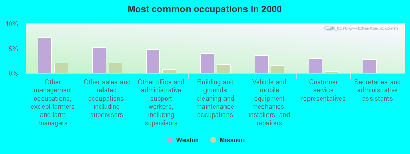
- Other management occupations, except farmers and farm managers (7.2%)
- Other sales and related occupations, including supervisors (5.3%)
- Other office and administrative support workers, including supervisors (4.8%)
- Building and grounds cleaning and maintenance occupations (4.0%)
- Vehicle and mobile equipment mechanics, installers, and repairers (3.6%)
- Customer service representatives (3.1%)
- Secretaries and administrative assistants (2.9%)
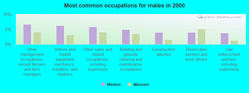
- Other management occupations, except farmers and farm managers (6.7%)
- Vehicle and mobile equipment mechanics, installers, and repairers (6.3%)
- Other sales and related occupations, including supervisors (5.8%)
- Building and grounds cleaning and maintenance occupations (4.9%)
- Construction laborers (4.0%)
- Driver/sales workers and truck drivers (4.0%)
- Law enforcement workers, including supervisors (3.8%)
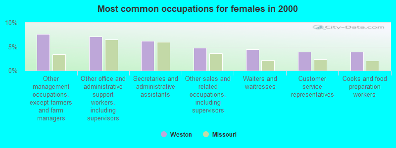
- Other management occupations, except farmers and farm managers (7.7%)
- Other office and administrative support workers, including supervisors (7.2%)
- Secretaries and administrative assistants (6.2%)
- Other sales and related occupations, including supervisors (4.7%)
- Waiters and waitresses (4.4%)
- Customer service representatives (4.0%)
- Cooks and food preparation workers (4.0%)
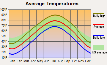
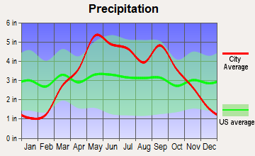
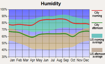
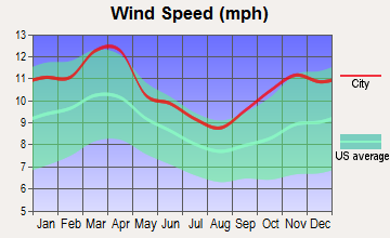
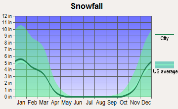
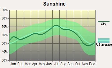
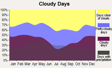
Average climate in Weston, Missouri
Based on data reported by over 4,000 weather stations
|
|


(lower is better)
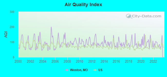
Air Quality Index (AQI) level in 2022 was 82.6. This is about average.
| City: | 82.6 |
| U.S.: | 72.6 |
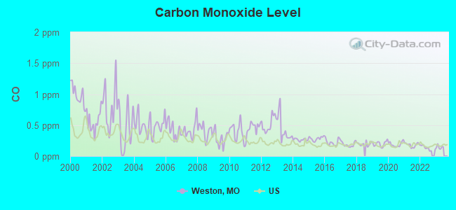
Carbon Monoxide (CO) [ppm] level in 2022 was 0.132. This is significantly better than average. Closest monitor was 8.6 miles away from the city center.
| City: | 0.132 |
| U.S.: | 0.251 |
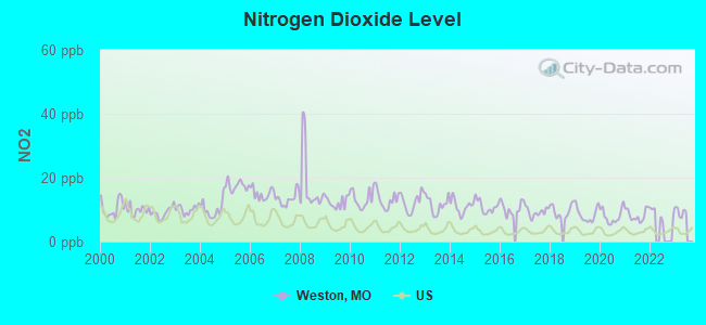
Nitrogen Dioxide (NO2) [ppb] level in 2021 was 8.27. This is significantly worse than average. Closest monitor was 6.9 miles away from the city center.
| City: | 8.27 |
| U.S.: | 5.11 |
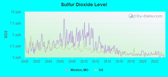
Sulfur Dioxide (SO2) [ppb] level in 2022 was 0.856. This is significantly better than average. Closest monitor was 6.9 miles away from the city center.
| City: | 0.856 |
| U.S.: | 1.515 |
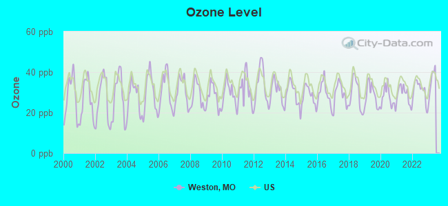
Ozone [ppb] level in 2022 was 30.8. This is about average. Closest monitor was 6.6 miles away from the city center.
| City: | 30.8 |
| U.S.: | 33.3 |
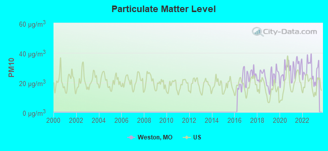
Particulate Matter (PM10) [µg/m3] level in 2022 was 29.1. This is significantly worse than average. Closest monitor was 22.8 miles away from the city center.
| City: | 29.1 |
| U.S.: | 19.2 |
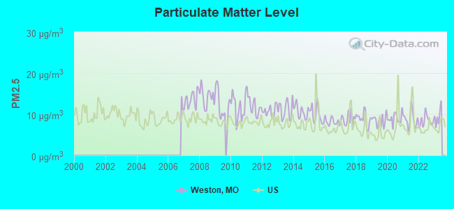
Particulate Matter (PM2.5) [µg/m3] level in 2022 was 8.35. This is about average. Closest monitor was 22.8 miles away from the city center.
| City: | 8.35 |
| U.S.: | 8.11 |
Tornado activity:
Weston-area historical tornado activity is slightly above Missouri state average. It is 107% greater than the overall U.S. average.
On 6/8/1966, a category F4 (max. wind speeds 207-260 mph) tornado 10.6 miles away from the Weston city center killed one person and injured 2 people and caused between $50,000 and $500,000 in damages.
On 5/7/1961, a category F4 tornado 16.9 miles away from the city center injured 12 people and caused between $500,000 and $5,000,000 in damages.
Earthquake activity:
Weston-area historical earthquake activity is significantly above Missouri state average. It is 484% greater than the overall U.S. average.On 9/3/2016 at 12:02:44, a magnitude 5.8 (5.8 MW, Depth: 3.5 mi, Class: Moderate, Intensity: VI - VII) earthquake occurred 234.5 miles away from the city center
On 11/6/2011 at 03:53:10, a magnitude 5.7 (5.7 MW, Depth: 3.2 mi) earthquake occurred 287.3 miles away from Weston center
On 11/12/2014 at 21:40:00, a magnitude 4.9 (4.9 MW, Depth: 2.5 mi, Class: Light, Intensity: IV - V) earthquake occurred 209.2 miles away from Weston center
On 11/7/2016 at 01:44:24, a magnitude 5.0 (5.0 MW, Depth: 2.8 mi) earthquake occurred 258.7 miles away from the city center
On 2/13/2016 at 17:07:06, a magnitude 5.1 (5.1 MW, Depth: 5.2 mi) earthquake occurred 289.9 miles away from Weston center
On 1/19/2020 at 19:08:42, a magnitude 4.5 (4.5 MW, Depth: 3.1 mi) earthquake occurred 191.7 miles away from Weston center
Magnitude types: moment magnitude (MW)
Natural disasters:
The number of natural disasters in Platte County (24) is greater than the US average (15).Major Disasters (Presidential) Declared: 15
Emergencies Declared: 6
Causes of natural disasters: Floods: 16, Storms: 14, Tornadoes: 4, Winter Storms: 4, Winds: 2, Drought: 1, Hurricane: 1, Ice Storm: 1, Snowstorm: 1, Other: 1 (Note: some incidents may be assigned to more than one category).

Hospitals and medical centers near Weston:
- HILLVIEW NURSING AND REHAB (Nursing Home, about 7 miles away; PLATTE CITY, MO)
- THREE RIVERS HOSPICE, INC (Hospital, about 7 miles away; PLATTE CITY, MO)
- LEAVENWORTH DIALYSIS (Dialysis Facility, about 7 miles away; LEAVENWORTH, KS)
- CUSHING COMMUNITY HOME HEALTH (Home Health Center, about 8 miles away; LEAVENWORTH, KS)
- CUSHING MEMORIAL HOSPITAL Acute Care Hospitals (about 8 miles away; LEAVENWORTH, KS)
- MEDICALODGES LEAVENWORTH (Nursing Home, about 8 miles away; LEAVENWORTH, KS)
- BROADWAY HEIGHTS OF LEAVENWORTH COUNTY (Nursing Home, about 8 miles away; LEAVENWORTH, KS)
Airports located in Weston:
- Louise's Strip Airport (40MO) (Runways: 1)
- Schaback Strip Airport (MO51) (Runways: 1)
- Vandahl Airport (MU71) (Runways: 1)
Colleges/universities with over 2000 students nearest to Weston:
- Grantham University (about 17 miles; Kansas City, MO; Full-time enrollment: 8,385)
- Park University (about 20 miles; Parkville, MO; FT enrollment: 9,131)
- Kansas City Kansas Community College (about 22 miles; Kansas City, KS; FT enrollment: 4,718)
- Missouri Western State University (about 25 miles; Saint Joseph, MO; FT enrollment: 4,557)
- Metropolitan Community College-Kansas City (about 29 miles; Kansas City, MO; FT enrollment: 12,834)
- University of Missouri-Kansas City (about 32 miles; Kansas City, MO; FT enrollment: 10,544)
- Rockhurst University (about 32 miles; Kansas City, MO; FT enrollment: 2,013)
Public high school in Weston:
- WEST PLATTE HIGH (Students: 351, Location: 935 WASHINGTON ST, Grades: 7-12)
Public elementary/middle school in Weston:
- CENTRAL ELEM. (Students: 304, Location: 1025 WASHINGTON ST, Grades: PK-6)
Points of interest:
Notable location: West Platte Fire Protection District (A). Display/hide its location on the map
Cemeteries: Laurel Hill Cemetery (1), Graceland Cemetery (2). Display/hide their locations on the map
Streams, rivers, and creeks: Brills Creek (A), Benner Branch (B), Pedee Creek (C), Wells Branch (D). Display/hide their locations on the map
Tourist attraction: Bonnell Museum (20755 Lamar Road).
Hotel: Inn at Weston Landing (526 Welt Street).
| This city: | 2.3 people |
| Missouri: | 2.5 people |
| This city: | 65.1% |
| Whole state: | 65.3% |
| This city: | 4.0% |
| Whole state: | 6.7% |
Likely homosexual households (counted as self-reported same-sex unmarried-partner households)
- Lesbian couples: 0.4% of all households
- Gay men: 0.0% of all households
Banks with branches in Weston (2011 data):
- Bank of Weston: Bank Of Weston at 18255 Highway 45 North, branch established on 1893/03/21. Info updated 2006/11/03: Bank assets: $112.2 mil, Deposits: $103.7 mil, local headquarters, positive income, Commercial Lending Specialization, 5 total offices, Holding Company: Wilson Bancshares, Inc.
For population 15 years and over in Weston:
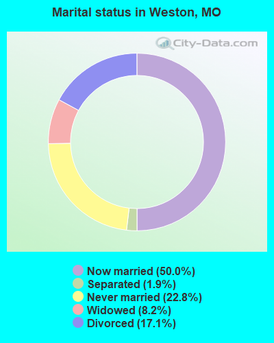
- Never married: 22.8%
- Now married: 50.0%
- Separated: 1.9%
- Widowed: 8.2%
- Divorced: 17.1%
For population 25 years and over in Weston:
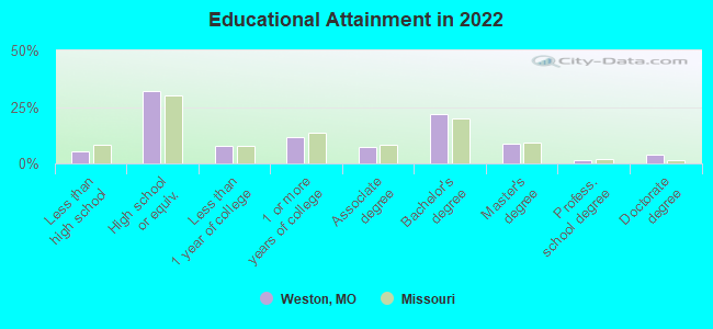
- High school or higher: 95.1%
- Bachelor's degree or higher: 36.0%
- Graduate or professional degree: 13.5%
- Unemployed: 2.2%
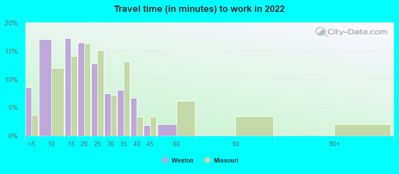
- Mean travel time to work (commute): 22.4 minutes
| Here: | 10.7 |
| Missouri average: | 11.1 |
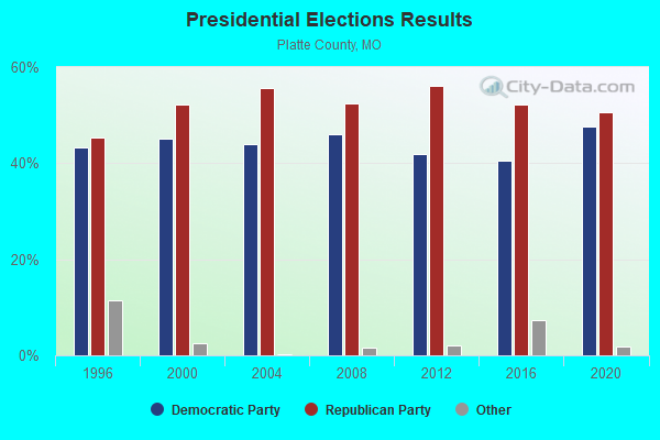
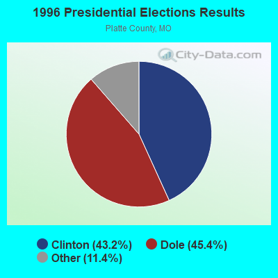
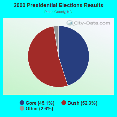
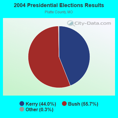
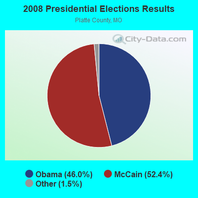
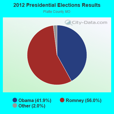

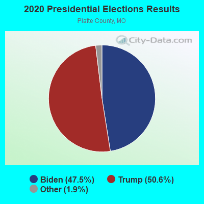
Graphs represent county-level data. Detailed 2008 Election Results
Religion statistics for Weston, MO (based on Platte County data)
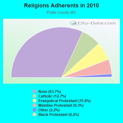
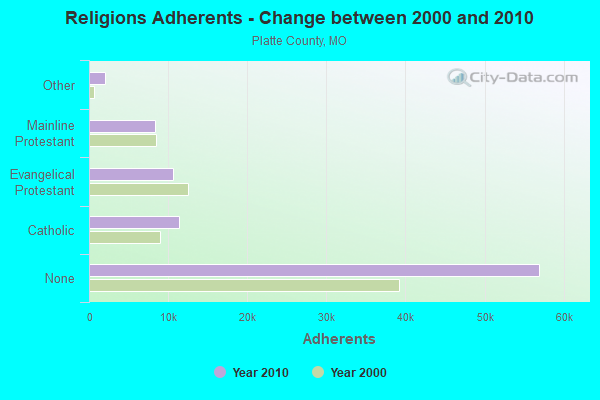
| Religion | Adherents | Congregations |
|---|---|---|
| Catholic | 11,380 | 3 |
| Evangelical Protestant | 10,560 | 41 |
| Mainline Protestant | 8,281 | 21 |
| Other | 1,974 | 9 |
| Black Protestant | 185 | 1 |
| Orthodox | - | - |
| None | 56,942 | - |
Food Environment Statistics:
| Here: | 1.53 / 10,000 pop. |
| Missouri: | 1.88 / 10,000 pop. |
| This county: | 0.12 / 10,000 pop. |
| State: | 0.18 / 10,000 pop. |
| Platte County: | 0.12 / 10,000 pop. |
| Missouri: | 0.60 / 10,000 pop. |
| Platte County: | 2.83 / 10,000 pop. |
| Missouri: | 4.34 / 10,000 pop. |
| Platte County: | 8.62 / 10,000 pop. |
| Missouri: | 7.37 / 10,000 pop. |
| Platte County: | 7.7% |
| Missouri: | 8.8% |
| Platte County: | 29.0% |
| Missouri: | 29.6% |
| Platte County: | 15.6% |
| State: | 13.5% |
Health and Nutrition:
| Weston: | 52.3% |
| Missouri: | 50.9% |
| Weston: | 51.5% |
| Missouri: | 48.6% |
| Weston: | 28.5 |
| Missouri: | 28.7 |
| This city: | 23.4% |
| State: | 20.6% |
| Weston: | 8.2% |
| Missouri: | 10.1% |
| Weston: | 6.9 |
| Missouri: | 6.8 |
| Weston: | 34.9% |
| State: | 34.3% |
| Weston: | 58.0% |
| Missouri: | 57.5% |
| Weston: | 78.5% |
| Missouri: | 79.3% |
More about Health and Nutrition of Weston, MO Residents
| Local government employment and payroll (March 2022) | |||||
| Function | Full-time employees | Monthly full-time payroll | Average yearly full-time wage | Part-time employees | Monthly part-time payroll |
|---|---|---|---|---|---|
| Police Protection - Officers | 5 | $50,684 | $121,642 | 3 | $5,351 |
| Judicial and Legal | 3 | $5,742 | $22,968 | 0 | $0 |
| Water Supply | 3 | $6,760 | $27,040 | 2 | $2,293 |
| Sewerage | 1 | $3,634 | $43,608 | 0 | $0 |
| Streets and Highways | 1 | $5,463 | $65,556 | 2 | $1,815 |
| Financial Administration | 0 | $0 | 1 | $742 | |
| Other Government Administration | 0 | $0 | 5 | $1,104 | |
| Totals for Government | 13 | $72,284 | $66,724 | 13 | $11,305 |
Weston government finances - Expenditure in 2017 (per resident):
- Construction - Regular Highways: $1,984,000 ($1110.24)
Sewerage: $24,000 ($13.43)
General - Other: $1,000 ($0.56)
- Current Operations - Water Utilities: $462,000 ($258.53)
Police Protection: $343,000 ($191.94)
General - Other: $244,000 ($136.54)
Solid Waste Management: $188,000 ($105.20)
Regular Highways: $180,000 ($100.73)
Sewerage: $148,000 ($82.82)
Central Staff Services: $113,000 ($63.23)
General Public Buildings: $104,000 ($58.20)
Parks and Recreation: $30,000 ($16.79)
Judicial and Legal Services: $4,000 ($2.24)
Financial Administration: $2,000 ($1.12)
- Other Capital Outlay - Water Utilities: $13,000 ($7.27)
Police Protection: $3,000 ($1.68)
- Total Salaries and Wages: $698,000 ($390.60)
- Water Utilities - Interest on Debt: $64,000 ($35.81)
Weston government finances - Revenue in 2017 (per resident):
- Charges - Sewerage: $323,000 ($180.75)
Solid Waste Management: $188,000 ($105.20)
- Local Intergovernmental - Highways: $364,000 ($203.69)
- Miscellaneous - Rents: $31,000 ($17.35)
Fines and Forfeits: $26,000 ($14.55)
General Revenue - Other: $8,000 ($4.48)
Interest Earnings: $6,000 ($3.36)
Special Assessments: $3,000 ($1.68)
- Revenue - Water Utilities: $747,000 ($418.02)
- State Intergovernmental - Other: $63,000 ($35.25)
Highways: $51,000 ($28.54)
- Tax - General Sales and Gross Receipts: $609,000 ($340.79)
Property: $197,000 ($110.24)
Public Utilities Sales: $165,000 ($92.33)
Occupation and Business License - Other: $20,000 ($11.19)
Motor Vehicle License: $14,000 ($7.83)
Other: $10,000 ($5.60)
Weston government finances - Debt in 2017 (per resident):
- Long Term Debt - Outstanding Unspecified Public Purpose: $1,694,000 ($947.96)
Beginning Outstanding - Unspecified Public Purpose: $1,606,000 ($898.71)
Issue, Unspecified Public Purpose: $193,000 ($108.00)
Retired Unspecified Public Purpose: $105,000 ($58.76)
Weston government finances - Cash and Securities in 2017 (per resident):
- Other Funds - Cash and Securities: $1,254,000 ($701.73)
- Sinking Funds - Cash and Securities: $148,000 ($82.82)
12.47% of this county's 2021 resident taxpayers lived in other counties in 2020 ($71,417 average adjusted gross income)
| Here: | 12.47% |
| Missouri average: | 7.67% |
0.05% of residents moved from foreign countries ($363 average AGI)
Platte County: 0.05% Missouri average: 0.02%
Top counties from which taxpayers relocated into this county between 2020 and 2021:
| from Clay County, MO | |
| from Jackson County, MO | |
| from Johnson County, KS |
11.31% of this county's 2020 resident taxpayers moved to other counties in 2021 ($88,963 average adjusted gross income)
| Here: | 11.31% |
| Missouri average: | 7.51% |
0.05% of residents moved to foreign countries ($457 average AGI)
Platte County: 0.05% Missouri average: 0.01%
Top counties to which taxpayers relocated from this county between 2020 and 2021:
| to Clay County, MO | |
| to Jackson County, MO | |
| to Johnson County, KS |
Businesses in Weston, MO
- Subway: 1
- True Value: 1
Strongest AM radio stations in Weston:
- WHB (810 AM; 50 kW; KANSAS CITY, MO; Owner: UNION BROADCASTING, INC.)
- KKLO (1410 AM; 5 kW; LEAVENWORTH, KS; Owner: CHARA COMMUNICATIONS, INC.)
- KCMO (710 AM; 10 kW; KANSAS CITY, MO; Owner: SUSQUEHANNA KANSAS CITY PARTNERSHIP)
- KKHK (1250 AM; 25 kW; KANSAS CITY, KS)
- KFEQ (680 AM; 5 kW; ST. JOSEPH, MO; Owner: EAGLE RADIO, INC.)
- KCSP (610 AM; 5 kW; KANSAS CITY, MO; Owner: ENTERCOM KANSAS CITY LICENSE, LLC)
- KCCV (760 AM; daytime; 6 kW; OVERLAND PARK, KS; Owner: BOTT BROADCASTING COMPANY)
- KSFT (1550 AM; 5 kW; ST. JOSEPH, MO; Owner: EAGLE RADIO, INC)
- KXTR (1660 AM; 10 kW; KANSAS CITY, KS; Owner: ENTERCOM KANSAS CITY LICENSE, LLC)
- KCTE (1510 AM; daytime; 10 kW; INDEPENDENCE, MO; Owner: UNION BROADCASTING, INC.)
- KMBZ (980 AM; 5 kW; KANSAS CITY, MO; Owner: ENTERCOM KANSAS CITY LICENSE, LLC)
- KPHN (1190 AM; 5 kW; KANSAS CITY, MO; Owner: ABC, INC.)
- KOIL (1020 AM; 50 kW; PLATTSMOUTH, NE; Owner: WAITT RADIO, INC.)
Strongest FM radio stations in Weston:
- KKJO-FM (105.5 FM; ST. JOSEPH, MO; Owner: EAGLE RADIO, INC)
- KFKF-FM (94.1 FM; KANSAS CITY, KS; Owner: INFINITY RADIO SUBSIDIARY OPERATIONS INC.)
- KZPL (97.3 FM; LEE'S SUMMIT, MO; Owner: UNION FIRST BROADCASTING, LLC)
- KCMO-FM (94.9 FM; KANSAS CITY, MO; Owner: SUSQUEHANNA KANSAS CITY PARTNERSHIP)
- KSRC (102.1 FM; KANSAS CITY, MO; Owner: INFINITY RADIO OPERATIONS INC.)
- WDAF-FM (106.5 FM; LIBERTY, MO; Owner: ENTERCOM KANSAS CITY LICENSE, LLC)
- KUDL (98.1 FM; KANSAS CITY, KS; Owner: ENTERCOM KANSAS CITY LICENSE, LLC)
- KQRC-FM (98.9 FM; LEAVENWORTH, KS; Owner: ENTERCOM KANSAS CITY LICENSE, LLC)
- KRBZ (96.5 FM; KANSAS CITY, MO; Owner: ENTERCOM KANSAS CITY LICENSE, LLC)
- KYYS (99.7 FM; KANSAS CITY, MO; Owner: ENTERCOM KANSAS CITY LICENSE, LLC)
- KBEQ-FM (104.3 FM; KANSAS CITY, MO; Owner: INFINITY RADIO SUBSIDIARY OPERATIONS INC.)
- KMXV (93.3 FM; KANSAS CITY, MO; Owner: INFINITY RADIO OPERATIONS INC.)
- KPRS (103.3 FM; KANSAS CITY, MO; Owner: CARTER BROADCAST GROUP, INC.)
- KCUR-FM (89.3 FM; KANSAS CITY, MO; Owner: CURATORS OF UNIVERSITY OF MISSOURI)
- KLJC (88.5 FM; KANSAS CITY, MO; Owner: CALVARY BIBLE COLLEGE)
- KLZR (105.9 FM; LAWRENCE, KS; Owner: ZIMMER RADIO OF MID-MISSOURI, INC)
- KCCV-FM (92.3 FM; OLATHE, KS; Owner: BOTT BROADCASTING COMPANY)
- KKFI (90.1 FM; KANSAS CITY, MO; Owner: MID-COAST RADIO PROJECT, INC.)
TV broadcast stations around Weston:
- KTAJ (Channel 16; ST. JOSEPH, MO; Owner: TRINITY BROADCASTING NETWORK)
- KMBC-TV (Channel 9; KANSAS CITY, MO; Owner: KMBC HEARST-ARGYLE TELEVISION, INC.)
- KCTV (Channel 5; KANSAS CITY, MO; Owner: MEREDITH CORPORATION)
- KSHB-TV (Channel 41; KANSAS CITY, MO; Owner: SCRIPPS HOWARD BROADCASTING COMPANY)
- KCPT (Channel 19; KANSAS CITY, MO; Owner: PUBLIC TELEVISION 19, INC.)
- KCWE (Channel 29; KANSAS CITY, MO; Owner: KCWE-TV, INC.)
- KSMO-TV (Channel 62; KANSAS CITY, MO; Owner: KSMO LICENSEE, INC.)
- WDAF-TV (Channel 4; KANSAS CITY, MO; Owner: WDAF LICENSE, INC.)
- KQTV (Channel 2; ST. JOSEPH, MO; Owner: NEXSTAR BROADCASTING OF THE MIDWEST, INC.)
- KPXE (Channel 50; KANSAS CITY, MO; Owner: PAXSON KANSAS CITY LICENSE, INC.)
- KMCI (Channel 38; LAWRENCE, KS; Owner: SCRIPPS HOWARD BROADCASTING COMPANY)
- K48FS (Channel 48; KANSAS CITY, MO; Owner: WORD OF GOD FELLOWSHIP, INC.)
- K35CT (Channel 35; KANSAS CITY, MO; Owner: WORD OF GOD FELLOWSHIP, INC.)
- Weston, Missouri
- Fatal accident count8
- Vehicles involved in fatal accidents14
- Fatal accidents involving drunk persons:2
- Fatalities8
- Persons involved in fatal accidents17
- Pedestrians involved in fatal accidents2
- Missouri average
- Fatal accident count6484
- Vehicles involved in fatal accidents10100
- Fatal accidents involving drunk persons1747
- Fatalities7280
- Persons involved in fatal accidents16322
- Pedestrians involved in fatal accidents811
- National Bridge Inventory (NBI) Statistics
- 17Number of bridges
- 256ft / 77.5mTotal length
- $948,000Total costs
- 50,922Total average daily traffic
- 5,499Total average daily truck traffic
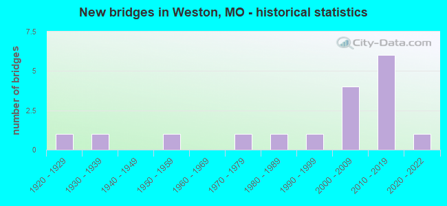
- New bridges - historical statistics
- 11920-1929
- 11930-1939
- 11950-1959
- 11970-1979
- 11980-1989
- 11990-1999
- 42000-2009
- 62010-2019
- 12020-2022
FCC Registered Cell Phone Towers:
2 (See the full list of FCC Registered Cell Phone Towers in Weston)FCC Registered Antenna Towers:
46 (See the full list of FCC Registered Antenna Towers)FCC Registered Broadcast Land Mobile Towers:
6- 1.6 Km S On Hwy 45 (Lat: 39.385833 Lon: -94.866917), Type: Building, Structure height: 6 m, Overall height: 8 m, Call Sign: WPLV846,
Assigned Frequencies: 151.310 MHz, Grant Date: 12/20/2022, Expiration Date: 03/17/2033, Certifier: Stephan B Moody, Registrant: Business Radio Licensing, 30251 Golden Lantern, Suite E#501, Laguna Niguel, CA 92677, Phone: (949) 348-8510, Fax: (949) 348-8514, Email:
- 1.6km S Of Weston On Hwy 45 (Lat: 39.385833 Lon: -94.866917), Type: Building, Structure height: 6 m, Overall height: 8 m, Call Sign: WPNR605,
Assigned Frequencies: 158.850 MHz, Grant Date: 03/21/2024, Expiration Date: 05/17/2034, Certifier: Stephen B Moody, Registrant: Business Radio Licensing, 30251 Golden Lantern, Suite E #501, Laguna Niguel, CA 92677, Phone: (949) 348-8510, Fax: (949) 348-8514, Email:
- Lat: 39.465556 Lon: -94.992472, Call Sign: KB88004,
Assigned Frequencies: 456.312 MHz, 451.412 MHz, 456.412 MHz, 456.512 MHz, 456.712 MHz, 452.062 MHz, 452.312 MHz, 452.550 MHz, 463.887 MHz, Grant Date: 04/19/2023, Expiration Date: 06/23/2033, Certifier: David H Grenier, Registrant: Midwest Mobile Radio Service Inc, 812 S 10th St, Saint Joseph, MO 64501, Phone: (816) 279-2065, Fax: (816) 233-8862, Email:
- WESTON DED, Bnsf Ls16 Mp38.0 Weston Ded (Lat: 39.408194 Lon: -94.902972), Type: Building, Structure height: 2.4 m, Overall height: 2.8 m, Call Sign: WPPF539,
Assigned Frequencies: 161.160 MHz, Grant Date: 09/26/2014, Expiration Date: 11/24/2024, Certifier: Robert C Leedham, Registrant: Bnsf Railway Co., 4515 Kansas Avenue, Kansas City, KS 66106, Phone: (913) 551-4640, Fax: (913) 551-4053, Email:
- EAST SADLER WIU, Bnsf Ls16 Mp32.9 East Sadler Wiu (Lat: 39.429750 Lon: -94.929750), Type: Building, Structure height: 2.7 m, Overall height: 5.5 m, Call Sign: WPCH306,
Assigned Frequencies: 160.725 MHz, Grant Date: 04/06/2023, Expiration Date: 05/21/2033, Registrant: Bnsf Railway Co., 4515 Kansas Ave, Kansas City, KS 66106, Phone: (913) 551-4015, Email:
- MP33.03 TOR, Bnsf Ls3000 Mp33.03 - Tor (Lat: 39.431500 Lon: -94.932111), Type: Tank, Structure height: 5.8 m, Overall height: 6.1 m, Call Sign: WQSB233,
Assigned Frequencies: 44.5800 MHz, Grant Date: 08/26/2013, Expiration Date: 08/26/2023, Cancellation Date: 10/28/2023, Certifier: Robert Leedham, Registrant: Prokarma, 222 So 15th St Suite 505n, Omaha, NE 68102, Phone: (402) 522-5068, Fax: (888) 956-8345, Email:
FCC Registered Microwave Towers:
14 (See the full list of FCC Registered Microwave Towers in this town)FCC Registered Amateur Radio Licenses:
16 (See the full list of FCC Registered Amateur Radio Licenses in Weston)FAA Registered Aircraft:
3- Aircraft: MOONEY M20C (Category: Land, Seats: 4, Weight: Up to 12,499 Pounds, Speed: 127 mph), Engine: LYCOMING O&VO-360 SER (180 HP) (Reciprocating)
N-Number: 6662R, N6662R, N-6662R, Serial Number: 2769, Year manufactured: 1964, Airworthiness Date: 07/23/1964, Certificate Issue Date: 09/30/2016
Registrant (Individual): Corey Weinfurt, Po Box 157, Weston, MO 64098 - Aircraft: PIPER PA-24-260 (Category: Land, Seats: 4, Weight: Up to 12,499 Pounds, Speed: 135 mph), Engine: LYCOMING TI0-540 SER (310 HP) (Reciprocating)
N-Number: 9241P, N9241P, N-9241P, Serial Number: 24-4740, Year manufactured: 1967, Airworthiness Date: 12/06/1967, Certificate Issue Date: 02/24/1988
Registrant (Individual): Jeffrey V Gaskill, 26160 Hwy Jj, Weston, MO 64098 - Aircraft: MAGRINI WILLIAM J XAIR-H (Category: Land, Seats: 2, Weight: Up to 12,499 Pounds), Engine: AMA/EXPR UNKNOWN ENG (Reciprocating)
N-Number: 929XH, N929XH, N-929XH, Serial Number: 929, Year manufactured: 2004, Airworthiness Date: 03/20/2004, Certificate Issue Date: 03/24/2011
Registrant (Individual): Bradley S Metzger, 27240 Stephanie Ln, Weston, MO 64098
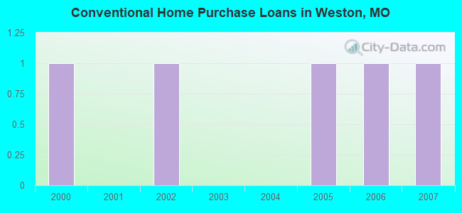
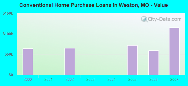
| Home Mortgage Disclosure Act Aggregated Statistics For Year 2009 (Based on 1 partial tract) | ||
| C) Refinancings | ||
|---|---|---|
| Number | Average Value | |
| LOANS ORIGINATED | 1 | $200,550 |
| APPLICATIONS APPROVED, NOT ACCEPTED | 0 | $0 |
| APPLICATIONS DENIED | 0 | $0 |
| APPLICATIONS WITHDRAWN | 0 | $0 |
| FILES CLOSED FOR INCOMPLETENESS | 0 | $0 |
Detailed HMDA statistics for the following Tracts: 0307.00
2002 - 2018 National Fire Incident Reporting System (NFIRS) incidents
- Fire incident types reported to NFIRS in Weston, MO
- 18663.3%Outside Fires
- 7726.2%Structure Fires
- 175.8%Mobile Property/Vehicle Fires
- 144.8%Other
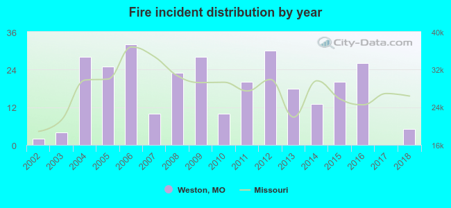 Based on the data from the years 2002 - 2018 the average number of fires per year is 17. The highest number of fires - 32 took place in 2006, and the least - 0 in 2017. The data has a growing trend.
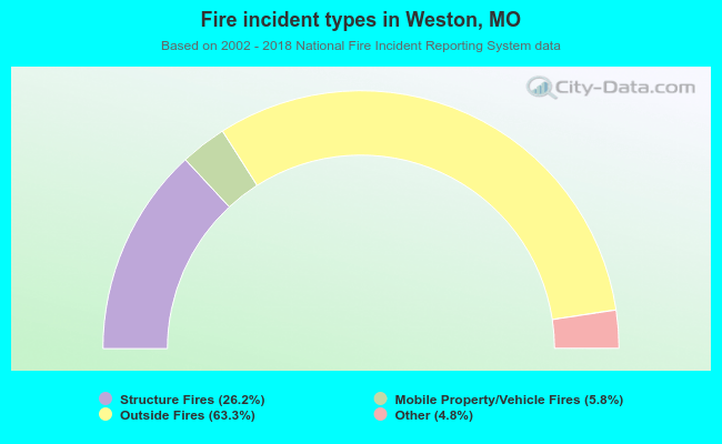 When looking into fire subcategories, the most incidents belonged to: Outside Fires (63.3%), and Structure Fires (26.2%).
| Most common first names in Weston, MO among deceased individuals | ||
| Name | Count | Lived (average) |
|---|---|---|
| James | 30 | 77.5 years |
| William | 27 | 75.3 years |
| John | 25 | 78.1 years |
| Mary | 24 | 81.7 years |
| Charles | 19 | 74.4 years |
| George | 11 | 78.4 years |
| Robert | 11 | 70.7 years |
| Helen | 10 | 80.0 years |
| Thomas | 9 | 76.8 years |
| David | 9 | 69.2 years |
| Most common last names in Weston, MO among deceased individuals | ||
| Last name | Count | Lived (average) |
|---|---|---|
| Hull | 14 | 76.1 years |
| Pepper | 12 | 78.7 years |
| Anderson | 11 | 68.9 years |
| Taulbee | 11 | 79.0 years |
| Lamar | 9 | 86.4 years |
| Jones | 9 | 72.9 years |
| Graves | 9 | 79.1 years |
| Goodpaster | 9 | 72.8 years |
| Turner | 8 | 75.3 years |
| Hall | 8 | 74.8 years |
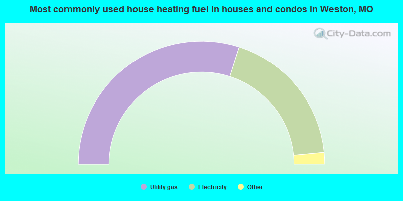
- 60.0%Utility gas
- 37.1%Electricity
- 1.7%Bottled, tank, or LP gas
- 1.2%Wood
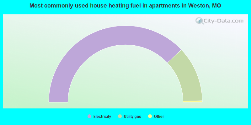
- 76.4%Electricity
- 23.6%Utility gas
Weston compared to Missouri state average:
- Unemployed percentage significantly below state average.
- Black race population percentage significantly below state average.
- Hispanic race population percentage below state average.
- Median age significantly above state average.
- Foreign-born population percentage below state average.
- Length of stay since moving in significantly above state average.
- Percentage of population with a bachelor's degree or higher above state average.

|
Total of 4 patent applications in 2008-2024.