Bridge Statistics for Williamsburg, Virginia (VA)
Condition, Traffic, Stress, Structural Evaluation, Project Costs
- National Bridge Inventory (NBI) Statistics
- 108Number of bridges
- 1,601ft / 488mTotal length
- $18,919,000Total costs
- 1,641,437Total average daily traffic
- 62,934Total average daily truck traffic
- National Bridge Inventory (NBI) Registered Bridges for Williamsburg
- No street view available for this location
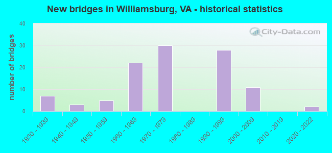
- New bridges - historical statistics
- 71930-1939
- 31940-1949
- 51950-1959
- 221960-1969
- 301970-1979
- 281990-1999
- 112000-2009
- 22020-2022
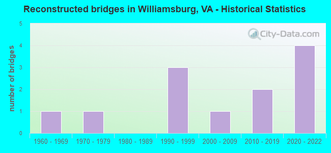
- Reconstructed bridges - Historical Statistics
- 11960-1969
- 11970-1979
- 01980-1989
- 31990-1999
- 12000-2009
- 22010-2019
- 42020-2022
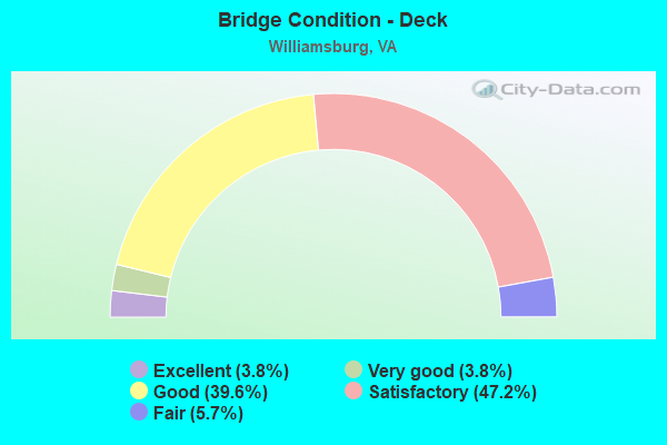
- Bridge Condition - Deck
- 3.8%Excellent
- 3.8%Very good
- 39.6%Good
- 47.2%Satisfactory
- 5.7%Fair
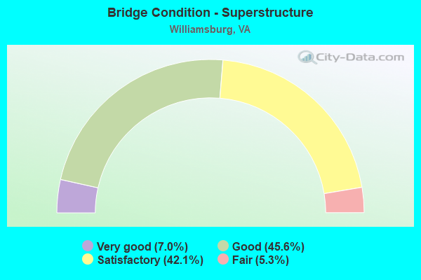
- Bridge Condition - Superstructure
- 7.0%Very good
- 45.6%Good
- 42.1%Satisfactory
- 5.3%Fair
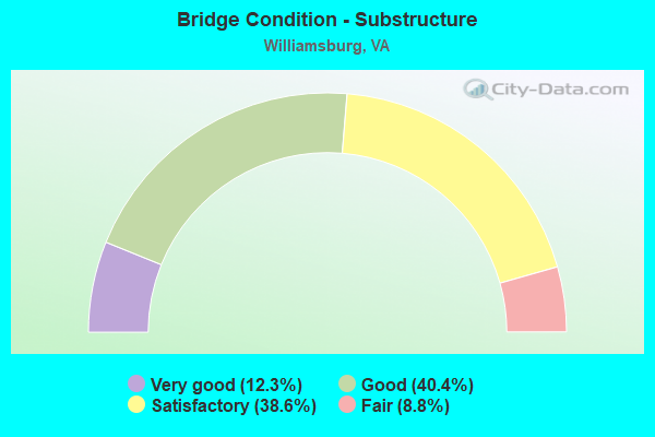
- Bridge Condition - Substructure
- 12.3%Very good
- 40.4%Good
- 38.6%Satisfactory
- 8.8%Fair
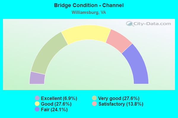
- Bridge Condition - Channel
- 6.9%Excellent
- 27.6%Very good
- 27.6%Good
- 13.8%Satisfactory
- 24.1%Fair
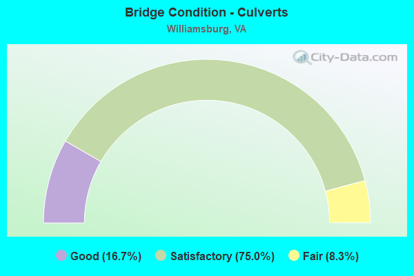
- Bridge Condition - Culverts
- 16.7%Good
- 75.0%Satisfactory
- 8.3%Fair
Find on map >> Show street view
Structure Number: 25206, Location: 0.90 Mi To Int Rte 60 (Lat: 37.310697, Lng: -76.747547), Route carried "under" structure: State highway 199, Year Built: 1999, Structure Length: 0. m, Average Daily Traffic: 15,000 (year 1996), Truck Traffic: 15%, Features Intersected: Route 199, Facility Carried by Structure: Olde Town Road
Minimum Vertical Clearance: 5.61m (18.41ft), Kilometerpoint: 0.000, Lanes on structure: 2, Lanes under structure: 4, Material/Design: Steel continuous, Design/Construction: Stringer/Multi-beam, Length of Maximum Span: 36.0m (118.1ft)
Find on map >> Show street view
Structure Number: 25207, Location: 0.60 Mi To Route 658 (Lat: 37.299206, Lng: -76.745864), Route carried "under" structure: County highway 199, Year Built: 1999, Structure Length: 0. m, Average Daily Traffic: 15,000 (year 1999), Features Intersected: Route 199, Facility Carried by Structure: Longhill Rd
Minimum Vertical Clearance: 6.20m (20.34ft), Kilometerpoint: 0.000, Lanes on structure: 4, Lanes under structure: 4, Material/Design: Steel continuous, Design/Construction: Stringer/Multi-beam, Length of Maximum Span: 37.5m (123.0ft)
Find on map >> Show street view
Structure Number: 25212, Location: 0.94 Mi To I-64 (Lat: 37.344206, Lng: -76.742650), Route carried "under" structure: County highway 646, Year Built: 1999, Structure Length: 0. m, Average Daily Traffic: 900 (year 1999), Truck Traffic: 5%, Features Intersected: Mooretown Rd, Facility Carried by Structure: Humelsine Pky SBL
Minimum Vertical Clearance: 5.87m (19.26ft), Kilometerpoint: 0.000, Lanes on structure: 3, Lanes under structure: 6, Material/Design: Prestressed concrete continuous, Design/Construction: Stringer/Multi-beam, Length of Maximum Span: 27.1m (88.9ft)
Find on map >> Show street view
Structure Number: 25213, Location: 0.90 Mi Fr I-64 (Lat: 37.344342, Lng: -76.742867), Route carried "under" structure: County highway 646, Year Built: 1999, Structure Length: 0. m, Average Daily Traffic: 900 (year 1999), Truck Traffic: 5%, Features Intersected: Mooretown Rd, Facility Carried by Structure: Humelsine Pkwy Nbl
Minimum Vertical Clearance: 5.94m (19.49ft), Kilometerpoint: 0.000, Lanes on structure: 3, Lanes under structure: 3, Material/Design: Prestressed concrete continuous, Design/Construction: Stringer/Multi-beam, Length of Maximum Span: 26.8m (87.9ft)
Find on map >> Show street view
Structure Number: 25281, Location: 0.00 Mi To 64 (Lat: 37.240589, Lng: -76.634275), Route carried "under" structure: Interstate 64, Year Built: 2002, Structure Length: 0. m, Average Daily Traffic: 79,000 (year 2012), Truck Traffic: 7%, Features Intersected: IS 64 EBL & WBL, Facility Carried by Structure: Ramps D & E
Minimum Vertical Clearance: 8.63m (28.31ft), Kilometerpoint: 0.000, Lanes on structure: 3, Lanes under structure: 3, Material/Design: Steel continuous, Design/Construction: Stringer/Multi-beam, Length of Maximum Span: 69.2m (227.0ft)
Find on map >> Show street view
Structure Number: 25282, Location: 0.00 Mi To Busch Gardens (Lat: 37.238253, Lng: -76.634489), Route carried "under" structure: Ramp Interstate 64, Year Built: 2002, Structure Length: 0. m, Average Daily Traffic: 8,000 (year 2000), Features Intersected: IS 64 Ramp, Facility Carried by Structure: Ramps D & E
Minimum Vertical Clearance: 9.53m (31.27ft), Kilometerpoint: 0.000, Lanes on structure: 5, Lanes under structure: 1, Material/Design: Steel continuous, Design/Construction: Stringer/Multi-beam, Length of Maximum Span: 26.5m (86.9ft)
Find on map >> Show street view
Structure Number: 25283, Location: 0.00 Mi To Busch Gardens (Lat: 37.237514, Lng: -76.634600), Route carried "under" structure: US 60, Year Built: 2002, Structure Length: 0. m, Average Daily Traffic: 15,095 (year 2000), Features Intersected: Route 143; 60 & CSX RR, Facility Carried by Structure: Ramps D & E
Minimum Vertical Clearance: 8.46m (27.76ft), Kilometerpoint: 0.000, Lanes on structure: 6, Lanes under structure: 5, Material/Design: Steel continuous, Design/Construction: Stringer/Multi-beam, Length of Maximum Span: 46.3m (151.9ft)
Find on map >> Show street view
Structure Number: 25283, Location: 0.00 Mi To Busch Gardens (Lat: 37.237514, Lng: -76.634600), Route carried "under" structure: State highway 143, Year Built: 2002, Structure Length: 0. m, Average Daily Traffic: 19,000 (year 1997), Truck Traffic: 10%, Features Intersected: Route 143; 60 & CSX RR, Facility Carried by Structure: Ramps D & E
Minimum Vertical Clearance: 8.59m (28.18ft), Kilometerpoint: 0.000, Lanes on structure: 6, Lanes under structure: 4, Material/Design: Steel continuous, Design/Construction: Stringer/Multi-beam, Length of Maximum Span: 46.3m (151.9ft)
Find on map >> Show street view
Structure Number: 25512, Location: 1.20 Mi To Route 5 (Lat: 37.273492, Lng: -76.752144), Route carried "under" structure: State highway 199, Year Built: 1999, Structure Length: 0. m, Average Daily Traffic: 14,985 (year 2014), Truck Traffic: 2%, Features Intersected: Monticello Ave
Minimum Vertical Clearance: 5.54m (18.18ft), Kilometerpoint: 0.000, Lanes on structure: 2, Lanes under structure: 2, Material/Design: Steel, Design/Construction: Stringer/Multi-beam, Length of Maximum Span: 56.1m (184.1ft)
Find on map >> Show street view
Structure Number: 25513, Location: 1.50 Mi To Route 5 (Lat: 37.273344, Lng: -76.752336), Route carried "under" structure: State highway 321, Year Built: 1999, Structure Length: 0. m, Average Daily Traffic: 2,500 (year 1999), Features Intersected: Monticello Ave, Facility Carried by Structure: Route 199 SBL
Minimum Vertical Clearance: 5.82m (19.09ft), Kilometerpoint: 0.000, Lanes on structure: 3, Lanes under structure: 2, Material/Design: Steel, Design/Construction: Stringer/Multi-beam, Length of Maximum Span: 55.8m (183.1ft)