Bridge Statistics for Youngsville, Louisiana (LA)
Condition, Traffic, Stress, Structural Evaluation, Project Costs
- National Bridge Inventory (NBI) Statistics
- 25Number of bridges
- 26,381ft / 8,041mTotal length
- $1,246,000Total costs
- 83,936Total average daily traffic
- 8,083Total average daily truck traffic
- 148,404Total future (year 204) average daily traffic
- National Bridge Inventory (NBI) Registered Bridges for Youngsville
- No street view available for this location
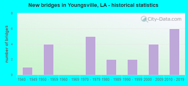
- New bridges - historical statistics
- 11940-1949
- 41950-1959
- 51970-1979
- 21980-1989
- 21990-1999
- 42000-2009
- 62010-2019

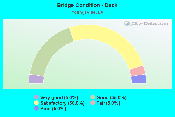
- Bridge Condition - Deck
- 5.0%Very good
- 35.0%Good
- 50.0%Satisfactory
- 5.0%Fair
- 5.0%Poor
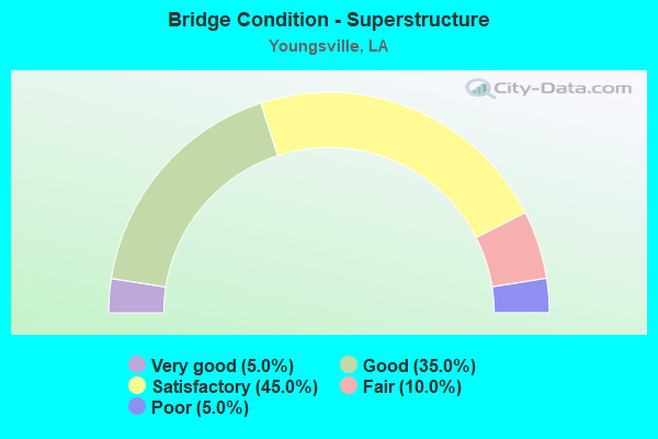
- Bridge Condition - Superstructure
- 5.0%Very good
- 35.0%Good
- 45.0%Satisfactory
- 10.0%Fair
- 5.0%Poor
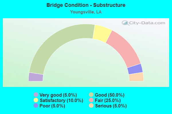
- Bridge Condition - Substructure
- 5.0%Very good
- 50.0%Good
- 10.0%Satisfactory
- 25.0%Fair
- 5.0%Poor
- 5.0%Serious
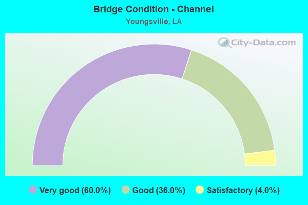
- Bridge Condition - Channel
- 60.0%Very good
- 36.0%Good
- 4.0%Satisfactory
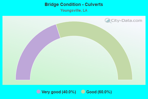
- Bridge Condition - Culverts
- 40.0%Very good
- 60.0%Good
Find on map >> Show street view
Structure Number: 32300000030464, Location: 0.6 MI. S. OF LA 88 (Lat: 30.036711, Lng: -91.964811), Route carried "on" structure: State highway 89, Year Built: 2016, Status: Open, Structure Length: 3.66m (12.01ft), Average Daily Traffic: 6,800 (year 2016), Truck Traffic: 13%, Average Future Daily Traffic: 1,170 (year 2036), Design Load: HS 20, Features Intersected: PARC PERDU BAYOU
Minimum Vertical Clearance: 30+ m (98+ ft), Kilometerpoint: 0.000, Lanes on structure: 2, Owner: State Highway Agency, Approaching Roadway Width: 7.6m (24.9ft), Skew: 30 degrees, Material/Design: Prestressed concrete continuous, Design/Construction: Stringer/Multi-beam, Number Of Spans In Main Unit: 3, Length of Maximum Span: 12.2m (40.0ft), Curb-To-Curb Width: 12.0m (39.4ft), Out-to-Out Width: 13.0m (42.7ft)
Condition: Deck: Very good, Superstructure: Very good, Substructure: Good, Channel: Very good, Operating Rating: 77.1 metric tons, Method Used To Determine Operating Rating: Load and Resistance Factor Rating (LRFR) rating reported by rating factor(RF) method using HL-93 loadings, Inventory Rating: 54.8 metric tons, Method Used To Determine Inventory Rating: Load and Resistance Factor Rating (LRFR) rating reported by rating factor(RF) method using HL-93 loadings, Structural Evaluation: Better than present minimum criteria, Deck Geometry: Somewhat better than minimum adequacy, Waterway Adequacy: Better than present minimum criteria, Approach Roadway Alignment: Equal to present desirable criteria, Designated Inspection Frequency: Every 24 months, Inspection Date: Febuary 2022, Deck Structure Type: Concrete Cast-file-Place, Wearing Surface/Protective System: Wearing Surface: Monolithic Concrete
Find on map >> Show street view
Structure Number: 32300000200702, Location: 1.21 Mi. SE. of La 89 (Lat: 30.030761, Lng: -91.944461), Route carried "on" structure: County highway , Year Built: 2011, Status: Posted for load, Structure Length: 2.07m (6.79ft), Average Daily Traffic: 215 (year 2021), Average Future Daily Traffic: 237 (year 2041), Design Load: HS 20, Features Intersected: Romero Branch Canal, Facility Carried by Structure: Chastant Rd
Minimum Vertical Clearance: 30+ m (98+ ft), Kilometerpoint: 0.000, Lanes on structure: 2, Owner: County Highway Agency, Approaching Roadway Width: 7.9m (25.9ft), Material/Design: Steel, Design/Construction: Girder and Floorbeam System, Number Of Spans In Main Unit: 1, Length of Maximum Span: 20.7m (67.9ft), Curb-To-Curb Width: 7.9m (25.9ft), Out-to-Out Width: 8.2m (26.9ft)
Condition: Deck: Good, Superstructure: Good, Substructure: Good, Channel: Very good, Operating Rating: 31.7 metric tons, Method Used To Determine Operating Rating: Load Factor (LF), Inventory Rating: 19.0 metric tons, Method Used To Determine Inventory Rating: Load Factor (LF), Structural Evaluation: Somewhat better than minimum adequacy, Deck Geometry: Somewhat better than minimum adequacy, Waterway Adequacy: Equal to present desirable criteria, Approach Roadway Alignment: Better than present minimum criteria, Bridge Posting: Required (Relationship of Operating Rating to Maximum Legal Load: 0.1 - 9.9% below), Designated Inspection Frequency: Every 24 months, Inspection Date: October 2020, Deck Structure Type: Corrugated Steel, Wearing Surface/Protective System: Wearing Surface: Bituminous
Find on map >> Show street view
Structure Number: 32308234100461, Location: 0.46 MI WEST OF LA 88 (Lat: 30.043581, Lng: -91.966200), Route carried "on" structure: State highway 89, Year Built: 1959, Status: Open, Structure Length: 2.44m (8.01ft), Average Daily Traffic: 4,600 (year 2016), Truck Traffic: 9%, Average Future Daily Traffic: 5,670 (year 2036), Design Load: H 15, Features Intersected: ROMERO CANAL
Minimum Vertical Clearance: 30+ m (98+ ft), Kilometerpoint: 0.391, Lanes on structure: 2, Owner: State Highway Agency, Approaching Roadway Width: 12.2m (40.0ft), Skew: 1 degrees, Material/Design: Concrete, Design/Construction: Slab, Number Of Spans In Main Unit: 4, Length of Maximum Span: 6.1m (20.0ft), Curb-To-Curb Width: 7.5m (24.6ft), Out-to-Out Width: 8.7m (28.5ft)
Condition: Deck: Satisfactory, Superstructure: Satisfactory, Substructure: Fair, Channel: Good, Operating Rating: 24.3 metric tons, Method Used To Determine Operating Rating: Load and Resistance Factor Rating (LRFR) rating reported by rating factor(RF) method using HL-93 loadings, Inventory Rating: 18.8 metric tons, Method Used To Determine Inventory Rating: Load and Resistance Factor Rating (LRFR) rating reported by rating factor(RF) method using HL-93 loadings, Structural Evaluation: Somewhat better than minimum adequacy, Deck Geometry: High priority of replacement, Waterway Adequacy: Equal to present desirable criteria, Approach Roadway Alignment: Equal to present desirable criteria, Length Of Structure Improvement: 3.23m (10.60ft), Designated Inspection Frequency: Every 24 months, Inspection Date: August 2020, Bridge Improvement Cost: $275,000, Total Project Cost: $412,000 ( Estimate for 2016), Deck Structure Type: Concrete Cast-file-Place
Find on map >> Show street view
Structure Number: 32800000000086, Location: 0.08 Mi East of LA 339 (Lat: 30.074250, Lng: -92.031111), Route carried "on" structure: County highway , Year Built: 2016, Status: Open, Structure Length: 0.76m (2.49ft), Average Daily Traffic: 572 (year 2022), Truck Traffic: 50%, Average Future Daily Traffic: 629 (year 2036), Design Load: HL 93, Features Intersected: Retention pond, Facility Carried by Structure: San Marcos Drive
Minimum Vertical Clearance: 30+ m (98+ ft), Kilometerpoint: 0.000, Lanes on structure: 2, Owner: County Highway Agency, Approaching Roadway Width: 7.6m (24.9ft), Material/Design: Concrete, Design/Construction: Culvert, Number Of Spans In Main Unit: 1, Length of Maximum Span: 7.3m (24.0ft), Curb-To-Curb Width: 15.2m (49.9ft), Out-to-Out Width: 15.9m (52.2ft)
Condition: Channel: Very good, Culverts: Very good, Operating Rating: 45.0 metric tons, Method Used To Determine Operating Rating: Load and Resistance Factor Rating (LRFR) rating reported by rating factor(RF) method using HL-93 loadings, Inventory Rating: 33.4 metric tons, Method Used To Determine Inventory Rating: Load and Resistance Factor Rating (LRFR) rating reported by rating factor(RF) method using HL-93 loadings, Structural Evaluation: Equal to present desirable criteria, Deck Geometry: Superior to present desirable criteria, Waterway Adequacy: Equal to present desirable criteria, Approach Roadway Alignment: Equal to present desirable criteria, Designated Inspection Frequency: Every 24 months, Inspection Date: January 2022
Find on map >> Show street view
Structure Number: 32800000030374, Location: 0.50 Mi W of La 89 (Lat: 30.087489, Lng: -91.997231), Route carried "on" structure: County highway , Year Built: 2008, Status: Open, Structure Length: 2.44m (8.01ft), Average Daily Traffic: 2,336 (year 2020), Average Future Daily Traffic: 5,743 (year 2040), Design Load: HS 20, Features Intersected: Parc Perdu Bayou, Facility Carried by Structure: Chemin Metairie
Minimum Vertical Clearance: 30+ m (98+ ft), Kilometerpoint: 0.000, Lanes on structure: 2, Owner: City or Municipal Highway Agency, Approaching Roadway Width: 12.2m (40.0ft), Skew: 3 degrees, Material/Design: Concrete, Design/Construction: Slab, Number Of Spans In Main Unit: 4, Length of Maximum Span: 6.1m (20.0ft), Curb-To-Curb Width: 11.9m (39.0ft), Out-to-Out Width: 13.1m (43.0ft)
Condition: Deck: Satisfactory, Superstructure: Satisfactory, Substructure: Good, Channel: Good, Operating Rating: 47.0 metric tons, Method Used To Determine Operating Rating: Load and Resistance Factor Rating (LRFR) rating reported by rating factor(RF) method using HL-93 loadings, Inventory Rating: 36.3 metric tons, Method Used To Determine Inventory Rating: Load and Resistance Factor Rating (LRFR) rating reported by rating factor(RF) method using HL-93 loadings, Structural Evaluation: Equal to present minimum criteria, Deck Geometry: Somewhat better than minimum adequacy, Waterway Adequacy: Equal to present desirable criteria, Approach Roadway Alignment: Equal to present minimum criteria, Designated Inspection Frequency: Every 24 months, Inspection Date: January 2022, Deck Structure Type: Concrete Precast Panels, Wearing Surface/Protective System: Wearing Surface: Monolithic Concrete
Find on map >> Show street view
Structure Number: 32800000030375, Location: 1.03 Mi W of La 89 (Lat: 30.090689, Lng: -92.005711), Route carried "on" structure: County highway , Year Built: 2008, Status: Open, Structure Length: 3.05m (10.01ft), Average Daily Traffic: 2,284 (year 2020), Average Future Daily Traffic: 5,615 (year 2040), Design Load: HS 20, Features Intersected: Parc Perdu Bayou, Facility Carried by Structure: Chemin Metairie
Minimum Vertical Clearance: 30+ m (98+ ft), Kilometerpoint: 0.000, Lanes on structure: 2, Owner: City or Municipal Highway Agency, Approaching Roadway Width: 12.2m (40.0ft), Material/Design: Concrete, Design/Construction: Slab, Number Of Spans In Main Unit: 5, Length of Maximum Span: 6.1m (20.0ft), Curb-To-Curb Width: 11.9m (39.0ft), Out-to-Out Width: 13.1m (43.0ft)
Condition: Deck: Good, Superstructure: Good, Substructure: Good, Channel: Good, Operating Rating: 47.0 metric tons, Method Used To Determine Operating Rating: Load and Resistance Factor Rating (LRFR) rating reported by rating factor(RF) method using HL-93 loadings, Inventory Rating: 36.3 metric tons, Method Used To Determine Inventory Rating: Load and Resistance Factor Rating (LRFR) rating reported by rating factor(RF) method using HL-93 loadings, Structural Evaluation: Better than present minimum criteria, Deck Geometry: Somewhat better than minimum adequacy, Waterway Adequacy: Equal to present desirable criteria, Approach Roadway Alignment: Equal to present desirable criteria, Designated Inspection Frequency: Every 24 months, Inspection Date: January 2022, Deck Structure Type: Other
Find on map >> Show street view
Structure Number: 32800000030376, Location: 0.40 Mi W of Lafayette St (Lat: 30.105111, Lng: -91.997131), Route carried "on" structure: County highway , Year Built: 2008, Status: Open, Structure Length: 0.85m (2.79ft), Average Daily Traffic: 158 (year 2020), Average Future Daily Traffic: 388 (year 2040), Design Load: HS 20, Features Intersected: Parc Perdu Bayou, Facility Carried by Structure: Copper Meadow Blvd
Minimum Vertical Clearance: 30+ m (98+ ft), Kilometerpoint: 0.000, Lanes on structure: 2, Owner: City or Municipal Highway Agency, Approaching Roadway Width: 8.2m (26.9ft), Material/Design: Prestressed concrete, Design/Construction: Culvert, Number Of Spans In Main Unit: 1, Length of Maximum Span: 8.5m (27.9ft), Curb-To-Curb Width: 10.7m (35.1ft), Out-to-Out Width: 14.6m (47.9ft)
Condition: Channel: Good, Culverts: Very good, Operating Rating: 36.6 metric tons, Method Used To Determine Operating Rating: Load and Resistance Factor Rating (LRFR) rating reported by rating factor(RF) method using HL-93 loadings, Inventory Rating: 28.5 metric tons, Method Used To Determine Inventory Rating: Load and Resistance Factor Rating (LRFR) rating reported by rating factor(RF) method using HL-93 loadings, Structural Evaluation: Better than present minimum criteria, Deck Geometry: Better than present minimum criteria, Waterway Adequacy: Equal to present desirable criteria, Approach Roadway Alignment: High priority of corrective action, Designated Inspection Frequency: Every 24 months, Inspection Date: January 2022, Deck Structure Type: Concrete Cast-file-Place
Find on map >> Show street view
Structure Number: 32800000030426, Location: 0.8 MI WEST OF US 90 (Lat: 30.101831, Lng: -91.955589), Route carried "on" structure: State highway 92, Year Built: 2012, Status: Open, Structure Length: 0.76m (2.49ft), Average Daily Traffic: 9,300 (year 2016), Truck Traffic: 9%, Average Future Daily Traffic: 11,466 (year 2036), Design Load: HS 20, Features Intersected: CYPRESS BAYOU COULEE
Minimum Vertical Clearance: 30+ m (98+ ft), Kilometerpoint: 2.923, Lanes on structure: 2, Owner: State Highway Agency, Approaching Roadway Width: 7.9m (25.9ft), Skew: 30 degrees, Material/Design: Concrete, Design/Construction: Culvert, Number Of Spans In Main Unit: 1, Length of Maximum Span: 7.6m (24.9ft), Curb-To-Curb Width: 12.5m (41.0ft), Out-to-Out Width: 19.2m (63.0ft)
Condition: Channel: Very good, Culverts: Good, Operating Rating: 42.1 metric tons, Method Used To Determine Operating Rating: Load and Resistance Factor Rating (LRFR) rating reported by rating factor(RF) method using HL-93 loadings, Inventory Rating: 33.0 metric tons, Method Used To Determine Inventory Rating: Load and Resistance Factor Rating (LRFR) rating reported by rating factor(RF) method using HL-93 loadings, Structural Evaluation: Better than present minimum criteria, Deck Geometry: Somewhat better than minimum adequacy, Waterway Adequacy: Equal to present desirable criteria, Approach Roadway Alignment: Equal to present desirable criteria, Designated Inspection Frequency: Every 24 months, Inspection Date: November 2021, Deck Structure Type: Concrete Cast-file-Place
Find on map >> Show street view
Structure Number: 32802130503001, Location: 0.01 MI EAST OF LA 339 (Lat: 30.109339, Lng: -92.031931), Route carried "on" structure: City street , Year Built: 1973, Status: Open, Structure Length: 1.74m (5.71ft), Average Daily Traffic: 8,700 (year 2020), Truck Traffic: 9%, Average Future Daily Traffic: 21,387 (year 2040), Design Load: HS 20, Features Intersected: ANSEIM COULEE, Facility Carried by Structure: E. Milton Ave.
Minimum Vertical Clearance: 30+ m (98+ ft), Kilometerpoint: 0.000, Lanes on structure: 2, Owner: County Highway Agency, Approaching Roadway Width: 7.3m (24.0ft), Material/Design: Concrete, Design/Construction: Slab, Number Of Spans In Main Unit: 3, Length of Maximum Span: 5.8m (19.0ft), Curb-To-Curb Width: 12.2m (40.0ft), Out-to-Out Width: 13.2m (43.3ft)
Condition: Deck: Satisfactory, Superstructure: Satisfactory, Substructure: Fair, Channel: Very good, Operating Rating: 39.2 metric tons, Method Used To Determine Operating Rating: Load and Resistance Factor Rating (LRFR) rating reported by rating factor(RF) method using HL-93 loadings, Inventory Rating: 30.1 metric tons, Method Used To Determine Inventory Rating: Load and Resistance Factor Rating (LRFR) rating reported by rating factor(RF) method using HL-93 loadings, Structural Evaluation: Somewhat better than minimum adequacy, Deck Geometry: Somewhat better than minimum adequacy, Waterway Adequacy: Equal to present desirable criteria, Approach Roadway Alignment: High priority of corrective action, Designated Inspection Frequency: Every 24 months, Inspection Date: January 2022, Deck Structure Type: Concrete Cast-file-Place, Wearing Surface/Protective System: Wearing Surface: Bituminous
Find on map >> Show street view
Structure Number: 32802130503541, Location: 0.55 MI EAST OF LA 339 (Lat: 30.109181, Lng: -92.022900), Route carried "on" structure: City street , Year Built: 1973, Status: Open, Structure Length: 1.74m (5.71ft), Average Daily Traffic: 8,700 (year 2020), Truck Traffic: 9%, Average Future Daily Traffic: 21,387 (year 2040), Design Load: HS 20, Features Intersected: CREEK, Facility Carried by Structure: E. Milton Ave.
Minimum Vertical Clearance: 30+ m (98+ ft), Kilometerpoint: 0.000, Lanes on structure: 2, Owner: County Highway Agency, Approaching Roadway Width: 7.3m (24.0ft), Material/Design: Concrete, Design/Construction: Slab, Number Of Spans In Main Unit: 3, Length of Maximum Span: 5.8m (19.0ft), Curb-To-Curb Width: 12.2m (40.0ft), Out-to-Out Width: 13.2m (43.3ft)
Condition: Deck: Satisfactory, Superstructure: Satisfactory, Substructure: Poor, Channel: Very good, Operating Rating: 39.2 metric tons, Method Used To Determine Operating Rating: Load and Resistance Factor Rating (LRFR) rating reported by rating factor(RF) method using HL-93 loadings, Inventory Rating: 30.1 metric tons, Method Used To Determine Inventory Rating: Load and Resistance Factor Rating (LRFR) rating reported by rating factor(RF) method using HL-93 loadings, Structural Evaluation: Meets minimum limits, Deck Geometry: Somewhat better than minimum adequacy, Waterway Adequacy: Equal to present desirable criteria, Approach Roadway Alignment: Equal to present desirable criteria, Designated Inspection Frequency: Every 24 months, Other Special Inspection Frequency: Every 12 months, Inspection Date: January 2022, Other Special Inspection Date: January 2023, Deck Structure Type: Concrete Cast-file-Place, Wearing Surface/Protective System: Wearing Surface: Bituminous
Find on map >> Show street view
Structure Number: 32802130505541, Location: 2.4 MI EAST OF LA 339 (Lat: 30.102011, Lng: -91.998019), Route carried "on" structure: City street , Year Built: 1973, Status: Open, Structure Length: 1.74m (5.71ft), Average Daily Traffic: 6,620 (year 2020), Truck Traffic: 9%, Average Future Daily Traffic: 16,274 (year 2040), Design Load: HS 20, Features Intersected: BAYOU PATE PERDU, Facility Carried by Structure: Iberia St
Minimum Vertical Clearance: 30+ m (98+ ft), Kilometerpoint: 0.000, Lanes on structure: 2, Owner: County Highway Agency, Approaching Roadway Width: 7.2m (23.6ft), Material/Design: Concrete, Design/Construction: Slab, Number Of Spans In Main Unit: 3, Length of Maximum Span: 5.8m (19.0ft), Curb-To-Curb Width: 12.2m (40.0ft), Out-to-Out Width: 13.2m (43.3ft)
Condition: Deck: Satisfactory, Superstructure: Satisfactory, Substructure: Fair, Channel: Very good, Operating Rating: 39.2 metric tons, Method Used To Determine Operating Rating: Load and Resistance Factor Rating (LRFR) rating reported by rating factor(RF) method using HL-93 loadings, Inventory Rating: 30.1 metric tons, Method Used To Determine Inventory Rating: Load and Resistance Factor Rating (LRFR) rating reported by rating factor(RF) method using HL-93 loadings, Structural Evaluation: Somewhat better than minimum adequacy, Deck Geometry: Somewhat better than minimum adequacy, Waterway Adequacy: Equal to present desirable criteria, Approach Roadway Alignment: Equal to present desirable criteria, Designated Inspection Frequency: Every 24 months, Inspection Date: January 2022, Deck Structure Type: Concrete Cast-file-Place, Wearing Surface/Protective System: Wearing Surface: Bituminous
Find on map >> Show street view
Structure Number: 32802130601051, Location: 1.05 MI EAST OF LA 89 (Lat: 30.101969, Lng: -91.974461), Route carried "on" structure: City street , Year Built: 1959, Status: Open, Structure Length: 1.83m (6.00ft), Average Daily Traffic: 7,700 (year 2020), Truck Traffic: 19%, Average Future Daily Traffic: 18,929 (year 2040), Design Load: H 15, Features Intersected: LASALLE COULEE, Facility Carried by Structure: Young St.
Minimum Vertical Clearance: 30+ m (98+ ft), Kilometerpoint: 0.000, Lanes on structure: 2, Owner: County Highway Agency, Approaching Roadway Width: 7.9m (25.9ft), Material/Design: Concrete, Design/Construction: Slab, Number Of Spans In Main Unit: 3, Length of Maximum Span: 6.1m (20.0ft), Curb-To-Curb Width: 7.3m (24.0ft), Out-to-Out Width: 9.0m (29.5ft)
Condition: Deck: Satisfactory, Superstructure: Satisfactory, Substructure: Good, Channel: Very good, Operating Rating: 37.2 metric tons, Method Used To Determine Operating Rating: Allowable Stress (AS), Inventory Rating: 22.7 metric tons, Method Used To Determine Inventory Rating: Allowable Stress (AS), Structural Evaluation: Somewhat better than minimum adequacy, Deck Geometry: High priority of replacement, Waterway Adequacy: Equal to present desirable criteria, Approach Roadway Alignment: Equal to present desirable criteria, Length Of Structure Improvement: 2.56m (8.40ft), Designated Inspection Frequency: Every 24 months, Inspection Date: October 2021, Bridge Improvement Cost: $152,000, Total Project Cost: $228,000 ( Estimate for 2016), Deck Structure Type: Concrete Cast-file-Place, Wearing Surface/Protective System: Wearing Surface: Bituminous
Find on map >> Show street view
Structure Number: 32802160201401, Location: 1.4 MI EAST OF LA 339 (Lat: 30.065661, Lng: -92.009200), Route carried "on" structure: State highway 734, Year Built: 1945, Status: Posted for load, Structure Length: 1.19m (3.90ft), Average Daily Traffic: 3,400 (year 2016), Truck Traffic: 13%, Average Future Daily Traffic: 4,284 (year 2036), Design Load: H 15, Features Intersected: BAYOU PARC PEROU
Minimum Vertical Clearance: 30+ m (98+ ft), Kilometerpoint: 2.237, Lanes on structure: 2, Owner: State Highway Agency, Approaching Roadway Width: 10.7m (35.1ft), Material/Design: Wood or Timber, Design/Construction: Stringer/Multi-beam, Number Of Spans In Main Unit: 2, Length of Maximum Span: 5.8m (19.0ft), Curb-To-Curb Width: 7.6m (24.9ft), Out-to-Out Width: 8.4m (27.6ft)
Condition: Deck: Satisfactory, Superstructure: Fair, Substructure: Fair, Channel: Satisfactory, Operating Rating: 23.6 metric tons, Method Used To Determine Operating Rating: Allowable Stress (AS), Inventory Rating: 15.4 metric tons, Method Used To Determine Inventory Rating: Allowable Stress (AS), Structural Evaluation: Meets minimum limits, Deck Geometry: High priority of replacement, Waterway Adequacy: Equal to present minimum criteria, Approach Roadway Alignment: Equal to present desirable criteria, Bridge Posting: Required (Relationship of Operating Rating to Maximum Legal Load: 0.1 - 9.9% below), Length Of Structure Improvement: 1.83m (6.00ft), Designated Inspection Frequency: Every 24 months, Inspection Date: May 2020, Bridge Improvement Cost: $156,000, Total Project Cost: $234,000 ( Estimate for 2016), Deck Structure Type: Wood or Timber, Wearing Surface/Protective System: Wearing Surface: Bituminous
Find on map >> Show street view
Structure Number: 32808281101321, Location: 0.25 MI WEST OF LA 734 (Lat: 30.065581, Lng: -92.027981), Route carried "on" structure: State highway 339, Year Built: 1957, Status: Open, Structure Length: 0.64m (2.10ft), Average Daily Traffic: 6,200 (year 2016), Truck Traffic: 9%, Average Future Daily Traffic: 7,938 (year 2036), Design Load: HS 20, Features Intersected: DARBY COULEE
Minimum Vertical Clearance: 30+ m (98+ ft), Kilometerpoint: 0.399, Lanes on structure: 2, Owner: State Highway Agency, Approaching Roadway Width: 7.3m (24.0ft), Skew: 3 degrees, Material/Design: Concrete, Design/Construction: Culvert, Number Of Spans In Main Unit: 3, Length of Maximum Span: 1.8m (5.9ft), Curb-To-Curb Width: 11.0m (36.1ft), Out-to-Out Width: 11.6m (38.1ft)
Condition: Channel: Good, Culverts: Good, Operating Rating: 42.1 metric tons, Method Used To Determine Operating Rating: Load and Resistance Factor Rating (LRFR) rating reported by rating factor(RF) method using HL-93 loadings, Inventory Rating: 32.4 metric tons, Method Used To Determine Inventory Rating: Load and Resistance Factor Rating (LRFR) rating reported by rating factor(RF) method using HL-93 loadings, Structural Evaluation: Better than present minimum criteria, Deck Geometry: Meets minimum limits, Waterway Adequacy: Equal to present desirable criteria, Approach Roadway Alignment: Equal to present desirable criteria, Designated Inspection Frequency: Every 24 months, Inspection Date: Febuary 2021, Deck Structure Type: Concrete Cast-file-Place
Find on map >> Show street view
Structure Number: 32808282500291, Location: 4.6 MI SOUTH OF LA 92 (Lat: 30.043531, Lng: -91.978000), Route carried "on" structure: State highway 89, Year Built: 1959, Status: Open, Structure Length: 0.64m (2.10ft), Average Daily Traffic: 4,600 (year 2016), Truck Traffic: 9%, Average Future Daily Traffic: 5,670 (year 2036), Design Load: HS 20, Features Intersected: CREEK
Minimum Vertical Clearance: 30+ m (98+ ft), Kilometerpoint: 1.527, Lanes on structure: 2, Owner: State Highway Agency, Approaching Roadway Width: 11.6m (38.1ft), Skew: 1 degrees, Material/Design: Concrete, Design/Construction: Culvert, Number Of Spans In Main Unit: 3, Length of Maximum Span: 1.8m (5.9ft), Curb-To-Curb Width: 14.9m (48.9ft), Out-to-Out Width: 15.2m (49.9ft)
Condition: Channel: Very good, Culverts: Good, Operating Rating: 42.1 metric tons, Method Used To Determine Operating Rating: Load and Resistance Factor Rating (LRFR) rating reported by rating factor(RF) method using HL-93 loadings, Inventory Rating: 32.4 metric tons, Method Used To Determine Inventory Rating: Load and Resistance Factor Rating (LRFR) rating reported by rating factor(RF) method using HL-93 loadings, Structural Evaluation: Better than present minimum criteria, Deck Geometry: Superior to present desirable criteria, Waterway Adequacy: Better than present minimum criteria, Approach Roadway Alignment: Equal to present desirable criteria, Designated Inspection Frequency: Every 24 months, Inspection Date: May 2020, Deck Structure Type: Concrete Cast-file-Place
Find on map >> Show street view
Structure Number: 32830039915861, Location: 2.36 Mi W of US 90 (Lat: 30.065569, Lng: -91.976031), Route carried "on" structure: County highway , Year Built: 1987, Status: Open, Structure Length: 1.74m (5.71ft), Average Daily Traffic: 1,550 (year 2020), Average Future Daily Traffic: 3,810 (year 2040), Design Load: HS 20, Features Intersected: COULEE, Facility Carried by Structure: Piat Rd.
Minimum Vertical Clearance: 30+ m (98+ ft), Kilometerpoint: 0.000, Lanes on structure: 2, Owner: County Highway Agency, Approaching Roadway Width: 6.2m (20.3ft), Skew: 6 degrees, Material/Design: Concrete, Design/Construction: Slab, Number Of Spans In Main Unit: 3, Length of Maximum Span: 5.8m (19.0ft), Curb-To-Curb Width: 7.4m (24.3ft), Out-to-Out Width: 8.2m (26.9ft)
Condition: Deck: Satisfactory, Superstructure: Satisfactory, Substructure: Satisfactory, Channel: Very good, Operating Rating: 81.6 metric tons, Method Used To Determine Operating Rating: Load Factor (LF), Inventory Rating: 49.0 metric tons, Method Used To Determine Inventory Rating: Load Factor (LF), Structural Evaluation: Equal to present minimum criteria, Deck Geometry: Meets minimum limits, Waterway Adequacy: Equal to present desirable criteria, Approach Roadway Alignment: Equal to present desirable criteria, Designated Inspection Frequency: Every 24 months, Inspection Date: October 2021, Deck Structure Type: Concrete Cast-file-Place
Find on map >> Show street view
Structure Number: 32830043915911, Location: 0.38 Mi E of LA 89 (Lat: 3.011725, Lng: -909.275103), Route carried "on" structure: County highway , Structure Length: 8000.17m (26247.28ft), Average Daily Traffic: 33 (year 0202), Average Future Daily Traffic: 1 (year 204), Features Intersected: COULEE, Facility Carried by Structure: Langlinais Rd.
Kilometerpoint: 9000.000, Lanes on structure: 70, Lanes under structure: 20, Approaching Roadway Width: 500.5m (1,642.1ft), Material/Design: Prestressed concrete, Design/Construction: Truss - Thru, Number Of Approach Spans: 3000, Length of Maximum Span: 3000.5m (9,844.2ft), Curb or Sidewalk Widths: Left: 40.0m (131.2ft), Right: 0.0m, Curb-To-Curb Width: 0.7m (2.3ft), Out-to-Out Width: 300.8m (986.9ft)
Condition: Deck: Satisfactory, Superstructure: Satisfactory, Substructure: Satisfactory, Channel: Very good, Operating Rating: 81.6 metric tons, Method Used To Determine Operating Rating: Allowable Stress (AS), Inventory Rating: 7.6 metric tons, Method Used To Determine Inventory Rating: Load and Resistance Factor Rating (LRFR) rating reported by rating factor(RF) method using HL-93 loadings, Waterway Adequacy: Equal to present desirable criteria, Designated Inspection Frequency: Every 2 months, Inspection Date: 2002, Deck Structure Type: Concrete Cast-file-Place
Find on map >> Show street view
Structure Number: 32830047920221, Location: 0.37 Mi SW of LA 339 (Lat: 30.078511, Lng: -92.037089), Route carried "on" structure: County highway , Year Built: 1985, Status: Posted for load, Structure Length: 1.86m (6.10ft), Average Daily Traffic: 16 (year 2020), Average Future Daily Traffic: 39 (year 2040), Design Load: HS 20, Features Intersected: DARBY COULEE, Facility Carried by Structure: Switzerland Rd.
Minimum Vertical Clearance: 30+ m (98+ ft), Kilometerpoint: 0.000, Lanes on structure: 2, Base Highway Network: Yes, Owner: County Highway Agency, Approaching Roadway Width: 6.1m (20.0ft), Material/Design: Steel, Design/Construction: Stringer/Multi-beam, Number Of Spans In Main Unit: 1, Length of Maximum Span: 18.6m (61.0ft), Curb-To-Curb Width: 5.5m (18.0ft), Out-to-Out Width: 6.2m (20.3ft)
Condition: Deck: Fair, Superstructure: Poor, Substructure: Good, Channel: Good, Operating Rating: 11.3 metric tons, Method Used To Determine Operating Rating: Load and Resistance Factor Rating (LRFR) rating reported by rating factor(RF) method using HL-93 loadings, Inventory Rating: 8.7 metric tons, Method Used To Determine Inventory Rating: Load and Resistance Factor Rating (LRFR) rating reported by rating factor(RF) method using HL-93 loadings, Structural Evaluation: High priority of replacement, Deck Geometry: Meets minimum limits, Waterway Adequacy: Equal to present desirable criteria, Approach Roadway Alignment: Equal to present desirable criteria, Bridge Posting: Required (Relationship of Operating Rating to Maximum Legal Load: > 39.9% below), Length Of Structure Improvement: 2.59m (8.50ft), Designated Inspection Frequency: Every 24 months, Other Special Inspection Frequency: Every 6 months, Inspection Date: January 2022, Other Special Inspection Date: July 2021, Bridge Improvement Cost: $154,000, Total Project Cost: $231,000 ( Estimate for 2016), Deck Structure Type: Other, Wearing Surface/Protective System: Wearing Surface: Other
Find on map >> Show street view
Structure Number: 32830053915751, Location: 1.3 M SW of LA 92 (Lat: 30.089150, Lng: -91.959119), Route carried "on" structure: County highway , Year Built: 1991, Status: Open, Structure Length: 1.74m (5.71ft), Average Daily Traffic: 320 (year 2020), Average Future Daily Traffic: 787 (year 2040), Design Load: HS 20, Features Intersected: LA SALLE COULEE, Facility Carried by Structure: Marteau Rd.
Minimum Vertical Clearance: 30+ m (98+ ft), Kilometerpoint: 0.000, Lanes on structure: 2, Owner: County Highway Agency, Approaching Roadway Width: 5.2m (17.1ft), Skew: 7 degrees, Material/Design: Concrete, Design/Construction: Slab, Number Of Spans In Main Unit: 3, Length of Maximum Span: 5.8m (19.0ft), Curb-To-Curb Width: 7.3m (24.0ft), Out-to-Out Width: 8.2m (26.9ft)
Condition: Deck: Good, Superstructure: Good, Substructure: Good, Channel: Very good, Operating Rating: 47.6 metric tons, Method Used To Determine Operating Rating: Load and Resistance Factor Rating (LRFR) rating reported by rating factor(RF) method using HL-93 loadings, Inventory Rating: 36.9 metric tons, Method Used To Determine Inventory Rating: Load and Resistance Factor Rating (LRFR) rating reported by rating factor(RF) method using HL-93 loadings, Structural Evaluation: Better than present minimum criteria, Deck Geometry: Somewhat better than minimum adequacy, Waterway Adequacy: Better than present minimum criteria, Approach Roadway Alignment: Equal to present desirable criteria, Designated Inspection Frequency: Every 24 months, Inspection Date: January 2022, Deck Structure Type: Concrete Precast Panels, Wearing Surface/Protective System: Wearing Surface: Monolithic Concrete
Find on map >> Show street view
Structure Number: 32830055920021, Location: 0.78 Mi SW of LA 89 (Lat: 30.094819, Lng: -92.004211), Route carried "on" structure: County highway , Year Built: 1975, Status: Posted for load, Structure Length: 1.74m (5.71ft), Average Daily Traffic: 840 (year 2020), Average Future Daily Traffic: 2,065 (year 2040), Design Load: HS 20, Features Intersected: PARC PERDU BAYOU, Facility Carried by Structure: Savoy Rd.
Minimum Vertical Clearance: 30+ m (98+ ft), Kilometerpoint: 0.000, Lanes on structure: 2, Owner: City or Municipal Highway Agency, Approaching Roadway Width: 6.7m (22.0ft), Material/Design: Concrete, Design/Construction: Slab, Number Of Spans In Main Unit: 3, Length of Maximum Span: 5.8m (19.0ft), Curb-To-Curb Width: 7.7m (25.3ft), Out-to-Out Width: 8.4m (27.6ft)
Condition: Deck: Satisfactory, Superstructure: Satisfactory, Substructure: Fair, Channel: Very good, Operating Rating: 25.3 metric tons, Method Used To Determine Operating Rating: Load and Resistance Factor Rating (LRFR) rating reported by rating factor(RF) method using HL-93 loadings, Inventory Rating: 19.4 metric tons, Method Used To Determine Inventory Rating: Load and Resistance Factor Rating (LRFR) rating reported by rating factor(RF) method using HL-93 loadings, Structural Evaluation: Somewhat better than minimum adequacy, Deck Geometry: Meets minimum limits, Waterway Adequacy: Equal to present desirable criteria, Approach Roadway Alignment: High priority of corrective action, Bridge Posting: Required (Relationship of Operating Rating to Maximum Legal Load: 20.0 - 29.9% below), Designated Inspection Frequency: Every 24 months, Inspection Date: January 2022, Deck Structure Type: Concrete Cast-file-Place
Find on map >> Show street view
Structure Number: 32830060915841, Location: 0.08 Mi S of LA 92 (Lat: 30.100811, Lng: -91.973669), Route carried "on" structure: County highway , Year Built: 2005, Status: Open, Structure Length: 1.16m (3.81ft), Average Daily Traffic: 766 (year 2020), Average Future Daily Traffic: 1,883 (year 2040), Design Load: HS 20, Features Intersected: LA SALLE COULEE, Facility Carried by Structure: S. Larriviere Rd.
Minimum Vertical Clearance: 30+ m (98+ ft), Kilometerpoint: 0.000, Lanes on structure: 2, Base Highway Network: Yes, Owner: City or Municipal Highway Agency, Approaching Roadway Width: 5.7m (18.7ft), Material/Design: Concrete, Design/Construction: Slab, Number Of Spans In Main Unit: 2, Length of Maximum Span: 5.8m (19.0ft), Curb-To-Curb Width: 7.2m (23.6ft), Out-to-Out Width: 8.3m (27.2ft)
Condition: Deck: Good, Superstructure: Good, Substructure: Good, Channel: Very good, Operating Rating: 55.7 metric tons, Method Used To Determine Operating Rating: Load and Resistance Factor Rating (LRFR) rating reported by rating factor(RF) method using HL-93 loadings, Inventory Rating: 43.1 metric tons, Method Used To Determine Inventory Rating: Load and Resistance Factor Rating (LRFR) rating reported by rating factor(RF) method using HL-93 loadings, Structural Evaluation: Better than present minimum criteria, Deck Geometry: Meets minimum limits, Waterway Adequacy: Equal to present desirable criteria, Approach Roadway Alignment: Equal to present desirable criteria, Designated Inspection Frequency: Every 24 months, Inspection Date: January 2022, Deck Structure Type: Other
Find on map >> Show street view
Structure Number: 32830065915861, Location: 1.0 Mi NE of LA 89 (Lat: 30.109231, Lng: -91.977311), Route carried "on" structure: County highway , Year Built: 1998, Status: Open, Structure Length: 1.74m (5.71ft), Average Daily Traffic: 2,420 (year 2020), Average Future Daily Traffic: 5,949 (year 2040), Design Load: HS 20, Features Intersected: LA SALLE COULEE, Facility Carried by Structure: Griffin Rd
Minimum Vertical Clearance: 30+ m (98+ ft), Kilometerpoint: 0.000, Lanes on structure: 2, Base Highway Network: Yes, Owner: City or Municipal Highway Agency, Approaching Roadway Width: 5.5m (18.0ft), Skew: 7 degrees, Material/Design: Concrete, Design/Construction: Slab, Number Of Spans In Main Unit: 3, Length of Maximum Span: 5.8m (19.0ft), Curb-To-Curb Width: 8.5m (27.9ft), Out-to-Out Width: 9.4m (30.8ft)
Condition: Deck: Good, Superstructure: Good, Substructure: Good, Channel: Very good, Operating Rating: 25.3 metric tons, Method Used To Determine Operating Rating: Load and Resistance Factor Rating (LRFR) rating reported by rating factor(RF) method using HL-93 loadings, Inventory Rating: 19.8 metric tons, Method Used To Determine Inventory Rating: Load and Resistance Factor Rating (LRFR) rating reported by rating factor(RF) method using HL-93 loadings, Structural Evaluation: Somewhat better than minimum adequacy, Deck Geometry: Meets minimum limits, Waterway Adequacy: Equal to present desirable criteria, Approach Roadway Alignment: Equal to present desirable criteria, Designated Inspection Frequency: Every 24 months, Inspection Date: January 2022, Deck Structure Type: Concrete Cast-file-Place, Wearing Surface/Protective System: Wearing Surface: Monolithic Concrete
Find on map >> Show street view
Structure Number: 32830078920071, Location: 0.60 Mi SW of LA 3025 (Lat: 30.130911, Lng: -92.012289), Route carried "on" structure: County highway , Year Built: 1972, Status: Posted for load, Structure Length: 0.94m (3.08ft), Average Daily Traffic: 40 (year 2020), Average Future Daily Traffic: 98 (year 2040), Design Load: H 15, Features Intersected: COULEE, Facility Carried by Structure: Serenity Rd.
Minimum Vertical Clearance: 30+ m (98+ ft), Kilometerpoint: 0.000, Lanes on structure: 2, Owner: City or Municipal Highway Agency, Approaching Roadway Width: 7.3m (24.0ft), Material/Design: Wood or Timber, Design/Construction: Stringer/Multi-beam, Number Of Spans In Main Unit: 2, Length of Maximum Span: 4.6m (15.1ft), Curb-To-Curb Width: 6.3m (20.7ft), Out-to-Out Width: 6.8m (22.3ft)
Condition: Deck: Poor, Superstructure: Fair, Substructure: Serious, Channel: Good, Operating Rating: 20.0 metric tons, Method Used To Determine Operating Rating: Allowable Stress (AS), Inventory Rating: 14.5 metric tons, Method Used To Determine Inventory Rating: Allowable Stress (AS), Structural Evaluation: High priority of corrective action, Deck Geometry: Somewhat better than minimum adequacy, Waterway Adequacy: Better than present minimum criteria, Approach Roadway Alignment: High priority of corrective action, Bridge Posting: Required (Relationship of Operating Rating to Maximum Legal Load: 0.1 - 9.9% below), Length Of Structure Improvement: 1.59m (5.22ft), Designated Inspection Frequency: Every 24 months, Other Special Inspection Frequency: Every 12 months, Inspection Date: October 2021, Other Special Inspection Date: October 2020, Bridge Improvement Cost: $94,000, Total Project Cost: $141,000 ( Estimate for 2016), Deck Structure Type: Wood or Timber, Wearing Surface/Protective System: Wearing Surface: Bituminous
Find on map >> Show street view
Structure Number: 35700000030447, Location: 1.2 MI N. OF LA 682 (Lat: 30.018869, Lng: -91.975600), Route carried "on" structure: State highway 89, Year Built: 2015, Status: Open, Structure Length: 1.83m (6.00ft), Average Daily Traffic: 4,800 (year 2016), Truck Traffic: 13%, Average Future Daily Traffic: 5,922 (year 2036), Design Load: HS 20, Features Intersected: CREEK
Minimum Vertical Clearance: 30+ m (98+ ft), Kilometerpoint: 8.048, Lanes on structure: 2, Owner: State Highway Agency, Approaching Roadway Width: 7.0m (23.0ft), Skew: 39 degrees, Material/Design: Concrete, Design/Construction: Slab, Number Of Spans In Main Unit: 3, Length of Maximum Span: 6.1m (20.0ft), Curb-To-Curb Width: 12.2m (40.0ft), Out-to-Out Width: 13.0m (42.7ft)
Condition: Deck: Good, Superstructure: Good, Substructure: Good, Channel: Good, Operating Rating: 59.9 metric tons, Method Used To Determine Operating Rating: Load and Resistance Factor Rating (LRFR) rating reported by rating factor(RF) method using HL-93 loadings, Inventory Rating: 46.3 metric tons, Method Used To Determine Inventory Rating: Load and Resistance Factor Rating (LRFR) rating reported by rating factor(RF) method using HL-93 loadings, Structural Evaluation: Better than present minimum criteria, Deck Geometry: Equal to present minimum criteria, Waterway Adequacy: Equal to present desirable criteria, Approach Roadway Alignment: Equal to present desirable criteria, Designated Inspection Frequency: Every 24 months, Inspection Date: August 2021, Deck Structure Type: Concrete Cast-file-Place, Wearing Surface/Protective System: Wearing Surface: Monolithic Concrete
Find on map >> Show street view
Structure Number: 35730021915991, Location: 0.9 Mi N of Germain Rd (Lat: 30.033989, Lng: -91.997981), Route carried "on" structure: County highway , Year Built: 2011, Status: Open, Structure Length: 2.32m (7.61ft), Average Daily Traffic: 966 (year 2021), Average Future Daily Traffic: 1,063 (year 2041), Design Load: H 10, Features Intersected: PARC PERDU BAYOU, Facility Carried by Structure: Dudley Rd
Minimum Vertical Clearance: 30+ m (98+ ft), Kilometerpoint: 0.000, Lanes on structure: 2, Owner: County Highway Agency, Approaching Roadway Width: 5.7m (18.7ft), Skew: 30 degrees, Material/Design: Concrete, Design/Construction: Slab, Number Of Spans In Main Unit: 4, Length of Maximum Span: 5.8m (19.0ft), Curb-To-Curb Width: 7.3m (24.0ft), Out-to-Out Width: 8.2m (26.9ft)
Condition: Deck: Good, Superstructure: Good, Substructure: Very good, Channel: Good, Operating Rating: 41.1 metric tons, Method Used To Determine Operating Rating: Load and Resistance Factor Rating (LRFR) rating reported by rating factor(RF) method using HL-93 loadings, Inventory Rating: 31.8 metric tons, Method Used To Determine Inventory Rating: Load and Resistance Factor Rating (LRFR) rating reported by rating factor(RF) method using HL-93 loadings, Structural Evaluation: Better than present minimum criteria, Deck Geometry: Meets minimum limits, Waterway Adequacy: Equal to present minimum criteria, Approach Roadway Alignment: Equal to present minimum criteria, Designated Inspection Frequency: Every 24 months, Inspection Date: September 2021, Deck Structure Type: Wood or Timber, Wearing Surface/Protective System: Wearing Surface: Wood or Timber