Please register to participate in our discussions with 2 million other members - it's free and quick! Some forums can only be seen by registered members. After you create your account, you'll be able to customize options and access all our 15,000 new posts/day with fewer ads.
I think so. There's no alerts anywhere in the Athabasca Basin. River volume at the town of Athabasca appears about average. It looks a little high further upstream, but not exceedingly so. I think most of the heavy rains fell further south (The North Saskatchewan originates in Banff Nat'l Park then flows north to Edmonton).
You can watch the water levels in the rivers here (just pick the appropriate area, choose a monitoring station and choose figure, as they're easier to read):
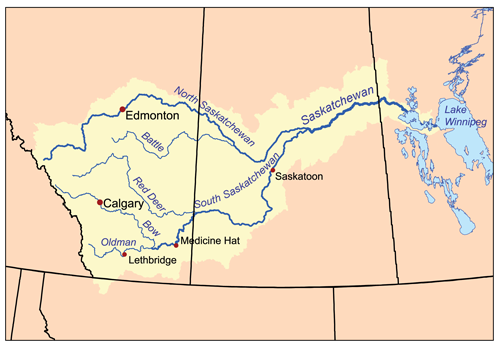
Looks like the Red Deer River is rising quite fast at Red Deer and Drumheller, as well as the South Saskatchewan at Medicine Hat. Further to the Southwest in Lethbridge, Calgary and High River, it looks like the worst has passed though?
Looks like the Red Deer River is rising quite fast at Red Deer and Drumheller, as well as the South Saskatchewan at Medicine Hat. Further to the Southwest in Lethbridge, Calgary and High River, it looks like the worst has passed though?
That sounds about right to me.
That Medicine Hat area's going to be hit hard right away. They get all the water from the Bow and the Oldman systems. I feel bad for them - they got flooded really badly a couple years ago, too.
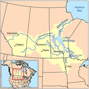
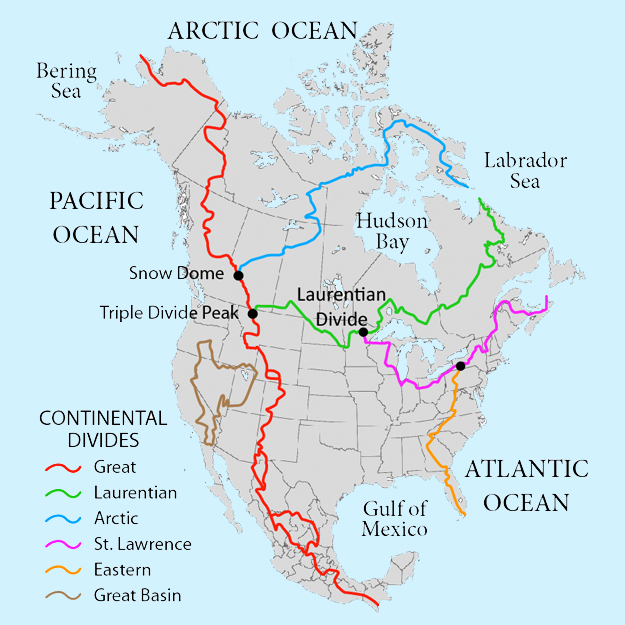
A question for any locals familiar with the river systems there who might know where the rivers flow to. Where is all that flood water going to end up in the long run? I know there's several rivers involved but what direction will it all be going in? Somebody on a different forum said that all the water from the various rivers eventually ends up crossing Saskatchewan and Manitoba and emptying out into Hudson's Bay but I'm having a hard time picturing that. Doesn't any of it go into the Great Lakes or across the border into some of the States?
A question for any locals familiar with the river systems there who might know where the rivers flow to. Where is all that flood water going to end up in the long run? I know there's several rivers involved but what direction will it all be going in? Somebody on a different forum said that all the water from the various rivers eventually ends up crossing Saskatchewan and Manitoba and emptying out into Hudson's Bay but I'm having a hard time picturing that. Doesn't any of it go into the Great Lakes or across the border into some of the States?
.
They were right. The Bow, and Oldman turn into the South Saskatchewan River. That water eventually ends up in the Nelson, and into Hudson's Bay.
While I'm sure some will make it to Superior thru Lake of the Woods, it's a pretty safe bet it will end up in Hudson's Bay lol
This is because of the way the continent is split up
My thoughts and prayers are going out to everyone who's affected by these terrible floods. Looking at the various news sites, I can't comprehend the level of damage. Is old Fort Calgary underwater? I would think so since it's so close to the river. Couldn't believe the photos of the Saddledome and Stampede Park.
As a weather forecaster in North Dakota and Minnesota and friends with many Canadians....I look at the flooding in Calgary and High River and soon to be Medicine Hat and other locations with great interest and knowing what we went through in Grand Forks ND 10+ years ago feel great pain for the losses.
But I do know as well, the Canadian and Prairie spirit is alive in well on both sides of the border and we take care of each other.
Please register to post and access all features of our very popular forum. It is free and quick. Over $68,000 in prizes has already been given out to active posters on our forum. Additional giveaways are planned.
Detailed information about all U.S. cities, counties, and zip codes on our site: City-data.com.

 Please register to participate in our discussions with 2 million other members - it's free and quick! Some forums can only be seen by registered members. After you create your account, you'll be able to customize options and access all our 15,000 new posts/day with fewer ads.