Please register to participate in our discussions with 2 million other members - it's free and quick! Some forums can only be seen by registered members. After you create your account, you'll be able to customize options and access all our 15,000 new posts/day with fewer ads.
I can think of several cities that make better use of the waterfront such as Santa Monica/LA, San Diego, SF (though the water is cold, the waterfront itself is used fairly well), Miami/South Beach, Honolulu, Rio, Barcelona, and others. Noticeably missing is NYC which I think has a mixed relationship with its waterfront.
Chicago is lucky in having that waterfront right up next to downtown. Walking underneath a busy highway is pretty close to what the Embarcadero was to get to it, but the Embarcadero had more passageways I think than the LSD.
Really off topic, but I strongly disagree about SF and LA making better use of waterfront than Chicago; I disagree on Miami as well. Either way, we can agree nobody would be against adding more public space to the Chicago Lakefront, but we disagree on how much of a hassle LSD really is; I guess one would have to actually live in the city to understand.
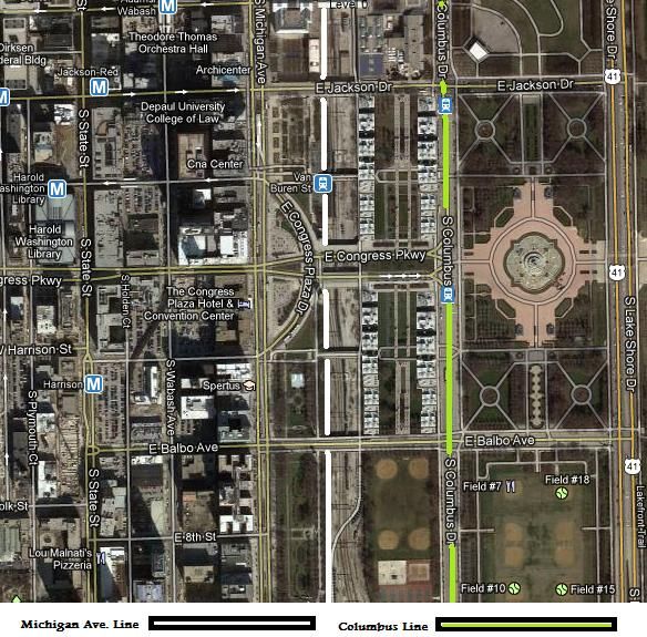
I think using the north and south land tracks for mix use would bring more foot traffic into the area. The buildings lining along Columbus Drive would sort like become a Collins Avenue or Ocean Drive facing the park. It could be lined with bars, clubs, restaurants, hotels, another museum and shops. The Columbus Line could be a light rail street car line starting at Navy Pier running along Illinois street passing the AMC theatres then turn south along Columbus Drive ending at McCormick Center. The Michgan Avenue line would be a CTA trains beginning in the Lincoln Park neighborhood running along Michigan Avenue as a subway line then cross over into the track area with Metra for tranfers then terminates at McCormick Center or run further south toward the Science Museum.
I think using the north and south land tracks for mix use would bring more foot traffic into the area. The buildings lining along Columbus Drive would sort like become a Collins Avenue or Ocean Drive facing the park. It could be lined with bars, clubs, restaurants, hotels, another museum and shops. The Columbus Line could be a light rail street car line starting at Navy Pier running along Illinois street passing the AMC theatres then turn south along Columbus Drive ending at McCormick Center. The Michgan Avenue line would be a CTA trains beginning in the Lincoln Park neighborhood running along Michigan Avenue as a subway line then cross over into the track area with Metra for tranfers then terminates at McCormick Center or run further south toward the Science Museum.
Columbus Line = CTA lightrail street car line
Michigan Avenue = CTA heavy rail line
That makes no sense. Why does Michigan Ave need a Heavy Rail Line? and a light rail line on Columbus? In addition, why would anybody want bars, clubs, restaurants in Grant Park
That makes no sense. Why does Michigan Ave need a Heavy Rail Line? and a light rail line on Columbus? In addition, why would anybody want bars, clubs, restaurants in Grant Park
Yeah that doesn't make sense. If lightrail was to go, it would make more sense to convert one of the lanes on LSD into the lightrail. I could see columbus having a light rail, but Michigan avenue definitely not as you already have heavy rail too close to that running on the red line.
There are some clubs/bars if you walk towards Navy Pier... I think that area could be improved and needs rail, but nothing in the middle of grant park.
That makes no sense. Why does Michigan Ave need a Heavy Rail Line? and a light rail line on Columbus? In addition, why would anybody want bars, clubs, restaurants in Grant Park
Just as one could say why does State Street need heavy rail? You do realize Michigan Avenue recieves good amount of foot traffic. Sure there are buses but it doesn't hurt to have more options. You sound conservative. I don't think it would take away from Grant Park if anything it would only add to it.
Just as one could say why does State Street need heavy rail? You do realize Michigan Avenue recieves good amount of foot traffic. Sure there are buses but it doesn't hurt to have more options. You sound conservative. I don't think it would take away from Grant Park if anything it would only add to it.
State street has heavy rail b/c state street is a major entertainment/shopping zone and brings people north/south directly into the CBD.
The argument was, the lakefront could be beautified by simply mitigating the size of Lake Shore Drive. Grant Park needs less roads and above ground stuff, if anything a subway stop out by Van Buren would be nice, but keep it underground somewhere around all those parking garages.
Basically the subway stop zones that are needed would be the New East Side Chicago, then the Navy Pier side before you get there, Grant Park, Oak Street area towards the lake, and possibly the area around Northwestern/Northwestern Hospital and Museum Campus. One sec and I will draw out a map.
Its actually not even bad the way it is but that highway by the W etc is pretty awful
Also a better pedestrian connection by the Navy Pier and the Spire site over to the by the Aqua and into grant park would be a plus - not easy to navigate on foot there
In the discussion of these two Philly has the same (or a smiliar issue with 95 blocking the path)
Some potential remedies - will see if anything ever happens
Just as one could say why does State Street need heavy rail? You do realize Michigan Avenue recieves good amount of foot traffic. Sure there are buses but it doesn't hurt to have more options. You sound conservative. I don't think it would take away from Grant Park if anything it would only add to it.
Michigan Ave doesn't need heavy rail, because heavy rail already exists on State Street which is a couple blocks away, there are dozens upon dozens of other rail needs than Michigan Ave rail. Michigan Ave is a hub for bus activity with several routes from Roosevelt up to Inner Drive. Dont like the bus? walk 3 min to state street and take the red line or one of the other 5 lines within a quick walk of much of Michigan ave. I sound conservative? How about realistic and logical, I don't live in a fantasy world.
Its actually not even bad the way it is but that highway by the W etc is pretty awful
Also a better pedestrian connection by the Navy Pier and the Spire site over to the by the Aqua and into grant park would be a plus - not easy to navigate on foot there
The issue with Lake Shore East is it has to deal with the multiple street levels. It is definitely a difficult area to navigate, but it is centrally located and not a far walk from Michigan ave, despite being poorly connected.
State street has heavy rail b/c state street is a major entertainment/shopping zone and brings people north/south directly into the CBD.
The argument was, the lakefront could be beautified by simply mitigating the size of Lake Shore Drive. Grant Park needs less roads and above ground stuff, if anything a subway stop out by Van Buren would be nice, but keep it underground somewhere around all those parking garages.
Basically the subway stop zones that are needed would be the New East Side Chicago, then the Navy Pier side before you get there, Grant Park, Oak Street area towards the lake, and possibly the area around Northwestern/Northwestern Hospital and Museum Campus. One sec and I will draw out a map.
Map... the sea foam green line...
That will work too
Please register to post and access all features of our very popular forum. It is free and quick. Over $68,000 in prizes has already been given out to active posters on our forum. Additional giveaways are planned.
Detailed information about all U.S. cities, counties, and zip codes on our site: City-data.com.

 Please register to participate in our discussions with 2 million other members - it's free and quick! Some forums can only be seen by registered members. After you create your account, you'll be able to customize options and access all our 15,000 new posts/day with fewer ads.