Please register to participate in our discussions with 2 million other members - it's free and quick! Some forums can only be seen by registered members. After you create your account, you'll be able to customize options and access all our 15,000 new posts/day with fewer ads.
Excuse me? The entire city of Chicago isn't a grid? Well, I suppose there's about 1% of the city which doesn't conform to the grid system if you count the rivers.
I mean, most of the city is, but it changes once you leave Chicago city limits, unlike the LA area.
All industrial cities are grids, its the most efficient way to fit a lot of people into a small space, if you have winding avenues, you can't fit as much into that space, L.A is a prime example of that. I personally like the grid system because you get cool vantage points, just look at NYC.
And the only reason L.A is so dense is because its blocked by mountains, and an ocean. Eventually the population will hit a cap, its only a matter of when though. It should start to cap off pretty soon, unless the State of California keeps inflating the population of L.A, making people believe it has a population of nearly 18 million in its CSA and 4.2 million in the city....live there and you know there isn't that many people.
And the only reason L.A is so dense is because its blocked by mountains, and an ocean. Eventually the population will hit a cap, its only a matter of when though. It should start to cap off pretty soon, unless the State of California keeps inflating the population of L.A, making people believe it has a population of nearly 18 million in its CSA and 4.2 million in the city....live there and you know there isn't that many people.
LA feels bigger than 18 million, but that 18 million comes from the Census, so I guess you should be "mad" at them for "inflating" LA's CSA. The CSA includes LA-Santa Ana, Riverside-San Bernardino, and Oxford. You get to near 18 million if you add those up (17,755,322, to be exact as of 2007).
Oh, and the Inland Empire sure isn't hemmed in by mountains, yet it continues to go out in a grid. Hell, it's the same thing with the Phoenix area. Most metro areas out west are built in better grids. The further east you go, the less "grid-like" the metros areas get.
...One I lived in L.A until fairly recently, so I know exactly what I'm talking about when I refer to it, and it sure as hell doesn't feel bigger than 18 million..
Also, New York is one HUGE grid, so you don't know what you're talking about, have you ever been to the east coast to make this presumption?
...One I lived in L.A until fairly recently, so I know exactly what I'm talking about when I refer to it, and it sure as hell doesn't feel bigger than 18 million..
So, because you say it doesn't feel like there is 18 million people there, everyone should feel that there isn't 18 million people there? Because you lived there doesn't mean anything. You can get a feel for how massive LA is by visiting (and the numerous times I have).
Quote:
Also, New York is one HUGE grid, so you don't know what you're talking about, have you ever been to the east coast to make this presumption?
I do know what I'm talking about, though not sure if you do. Of course the city of NY is a grid (who the hell said it wasn't), but once outside the city, it's sprawl land and streets go whichever way. You should re-read my post.
I mean, most of the city is, but it changes once you leave Chicago city limits, unlike the LA area.
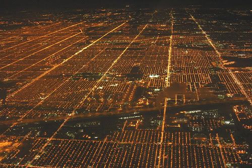
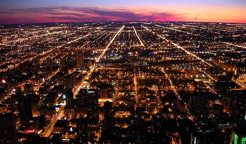
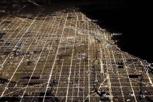
Chicago is the worlds largest grid. LA has some grids in the city, but there are many sepaprate grids. Chicago's is unique because it spreads over hundreds of square miles covering the entire city, extends out into the suburbs as well, and is entirely uniform and clean cut.
Every 4 blocks is a major street, and every 8 blocks is exactly 1 mile. You can measure exactly where you are in the city based on the address, east/west and north/south.
I don't know how much you've seen of Chicagoland, but the grid (especially the major arterial roads) extends impressively far into suburban Chicago.
Well I guess I wasn't paying attention. But wouldn't the urban area density be higher if it was a grid? Chicagoland is pretty sprawly.
Please register to post and access all features of our very popular forum. It is free and quick. Over $68,000 in prizes has already been given out to active posters on our forum. Additional giveaways are planned.
Detailed information about all U.S. cities, counties, and zip codes on our site: City-data.com.

 Please register to participate in our discussions with 2 million other members - it's free and quick! Some forums can only be seen by registered members. After you create your account, you'll be able to customize options and access all our 15,000 new posts/day with fewer ads.