Please register to participate in our discussions with 2 million other members - it's free and quick! Some forums can only be seen by registered members. After you create your account, you'll be able to customize options and access all our 15,000 new posts/day with fewer ads.
Thanks for advice, I am in agreement but husband
not so much although he is willing to go on an adventure!
Thinking weather will be fine mid to late week for
exploration of Maine.
Thanks for advice, I am in agreement but husband
not so much although he is willing to go on an adventure!
Thinking weather will be fine mid to late week for
exploration of Maine.
You realize nothing is happening anywhere but near the coast, right? Go. You're fine.
Look at the next 48hrs. See rain for the interior? None. They wont even be getting Tropical Storm force winds either. You'll be fine.
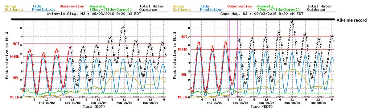
Like I said, try to avoid I-95 just from traffic and local flooding from water surge?
when was the last time we had a Hurricane sitting off the coast of NJ and NY? I see they have it a Cat 1 now for more than just a few hours. Wow.
I think coastal communities have voluntary evacuations in order?
2pm update: It's speed is slowing down. Was moving 20mph yesterday. So weird to see!
Quote:
BULLETIN POST-TROPICAL CYCLONE HERMINE INTERMEDIATE ADVISORY NUMBER 25A
NWS NATIONAL HURRICANE CENTER MIAMI FL AL092016
200 PM EDT SAT SEP 03 2016
...VERY STRONG WINDS AND SOUND-SIDE FLOODING OCCURRING OVER THE
NORTH CAROLINA OUTER BANKS...
...DANGEROUS STORM SURGE EXPECTED ALONG THE COAST FROM VIRGINIA TO NEW JERSEY...
SUMMARY OF 200 PM EDT...1800 UTC...INFORMATION
----------------------------------------------
LOCATION...36.0N 74.2W
ABOUT 90 MI...145 KM E OF DUCK NORTH CAROLINA
ABOUT 130 MI...215 KM ESE OF NORFOLK VIRGINIA MAXIMUM SUSTAINED WINDS...70 MPH...110 KM/H PRESENT MOVEMENT...E OR 85 DEGREES AT 10 MPH...17 KM/H
MINIMUM CENTRAL PRESSURE...995 MB...29.38 INCHES
WATCHES AND WARNINGS
--------------------
CHANGES WITH THIS ADVISORY:
None.
SUMMARY OF WATCHES AND WARNINGS IN EFFECT:
A Tropical Storm Warning is in effect for...
* Ocracoke Inlet to west of Watch Hill
* Pamlico and Albemarle Sounds
* Chesapeake Bay from Drum Point southward
* Tidal Potomac from Cobb Island eastward
* Delaware Bay
A Tropical Storm Watch is in effect for...
* Watch Hill to Sagamore Beach
* Block Island
* Martha's Vineyard
* Nantucket
A Tropical Storm Warning means that tropical storm conditions are
expected somewhere within the warning area within 36 hours.
A Tropical Storm Watch means that tropical storm conditions are
possible within the watch area, in this case within 36 to 48 hours.
For storm information specific to your area, including possible
inland watches and warnings, please monitor products issued by your
local National Weather Service forecast office.
DISCUSSION AND 48-HOUR OUTLOOK
------------------------------
At 200 PM EDT (1800 UTC), the center of Post-Tropical Cyclone
Hermine was located by an Air Force Reserve Hurricane Hunter
aircraft offshore of the North Carolina Outer Banks near latitude
36.0 North, longitude 74.2 West. Hermine has been moving toward the
east at around 10 mph (17 km/h) during the past few hours. A turn toward the northeast and a decrease in forward speed are expected by tonight, followed by a slow northward motion through early Monday.
On the forecast track, the center of Hermine will move away from the
North Carolina coast this afternoon and meander offshore of the
Delmarva Peninsula Sunday night and early Monday.
Surface data and data from the aircraft indicate that maximum
sustained winds are near 70 mph (110 km/h) with higher gusts. Some
strengthening is forecast during the next 24 hours, and Hermine is expected to be near hurricane intensity by Sunday.
Hermine is producing a large area of tropical-storm-force winds that extend outward up to 205 miles (335 km) from the center. A National
Ocean Service station at Duck Pier in North Carolina recently
reported a sustained wind of 56 mph (91 km/h) and a wind gust of 72
mph (117 km/h). A National Ocean Service station at the Coast Guard
station at Hatteras, North Carolina recently reported a sustained
wind of 48 mph (78 km/h) and a gust of 60 mph (97 km/h). NOAA buoy
44014, located about 75 miles (120 km) east of Virginia Beach
recently reported sustained winds of 54 mph (86 km/h) and a gust of
69 mph (112 km/h).
The estimated minimum central pressure is 995 mb (29.38 inches).
Southern Half of CT, also Rhode Island and Eastern MA is in the 60-70% range now to get SUSTAINED Tropical storm force winds. 40mph+
Please register to post and access all features of our very popular forum. It is free and quick. Over $68,000 in prizes has already been given out to active posters on our forum. Additional giveaways are planned.
Detailed information about all U.S. cities, counties, and zip codes on our site: City-data.com.

 Please register to participate in our discussions with 2 million other members - it's free and quick! Some forums can only be seen by registered members. After you create your account, you'll be able to customize options and access all our 15,000 new posts/day with fewer ads.