Welcome to City-Data.com Forum!
U.S. CitiesCity-Data Forum Index
Go Back   City-Data Forum > General Forums > Urban Planning
 [Register]
Please register to participate in our discussions with 2 million other members - it's free and quick! Some forums can only be seen by registered members. After you create your account, you'll be able to customize options and access all our 15,000 new posts/day with fewer ads.
View detailed profile (Advanced) or search
site with Google Custom Search

Search Forums  (Advanced)
 
Old 05-14-2014, 09:19 PM
 
Location: Fort Worth, Texas
156 posts, read 244,903 times
Reputation: 185

Advertisements

Fort Worth, Texas:


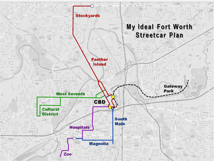
All four streetcar lines would converge at the two yellow dots downtown. The yellow dots are existing commuter rail stations, and white dots are planned commuter rail stations. My plan is to have commuter rail lines (not drawn) from the suburbs feed into this streetcar system at the yellow and white dots.

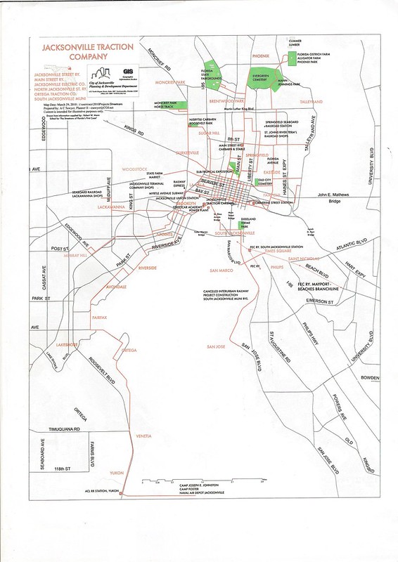
There is nothing special about Panther Island, South Main, or Gateway Park at the moment, but there are large-scale revitalization plans in the works for those areas.

The black dashed line would be elevated - perhaps a monorail instead of a streetcar.
Reply With Quote Quick reply to this message

 
Old 05-21-2014, 07:54 AM
 
Location: Sydney, Australia
11,655 posts, read 12,960,282 times
Reputation: 6391
How do you make these 'fantasy' maps?
Reply With Quote Quick reply to this message
 
Old 05-21-2014, 11:38 AM
 
Location: Richmond/Philadelphia/Brooklyn
1,264 posts, read 1,552,860 times
Reputation: 768
Depends, I like to use beno metro map creator
METRO MAP CREATOR
Reply With Quote Quick reply to this message
 
Old 05-21-2014, 08:08 PM
 
Location: Fort Worth, Texas
156 posts, read 244,903 times
Reputation: 185
Quote:
Originally Posted by theropod View Post
How do you make these 'fantasy' maps?
I used PowerPoint and drew lines over a map I captured.
Reply With Quote Quick reply to this message
 
Old 05-21-2014, 08:45 PM
 
Location: Fort Worth, Texas
156 posts, read 244,903 times
Reputation: 185
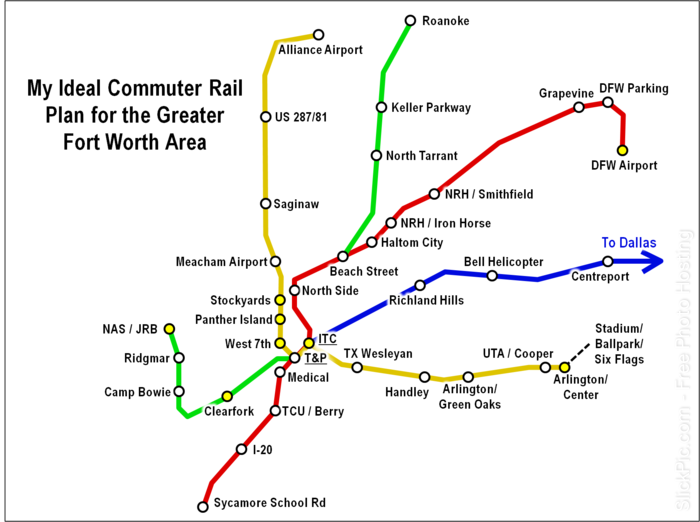
After finishing my streetcar plan, I decided to create a commuter rail plan:


The blue line is the existing commuter rail, and the red line is an already planned commuter rail. The green and yellow lines are my ideas.

The black dashed line would probably be a monorail to the stadium, ballpark, and Six Flags. However, I'm worried about it's capacity to handle big games (this is the reason the yellow line doesn't go north to the speedway). Both the stadium and ballpark have a lower capacity than the speedway, though.

The white dots are park and ride stations, and the yellow dots are not. All rail lines would converge at both downtown stations (T&P and ITC).
Reply With Quote Quick reply to this message
 
Old 05-27-2014, 11:50 AM
 
Location: Fairfax County, VA
3,718 posts, read 5,697,643 times
Reputation: 1480
Not my work, but from here Crossing the Lines: MARC, Revisited:


And from https://www.flickr.com/photos/rllayman/192900288/:

Reply With Quote Quick reply to this message
 
Old 08-08-2014, 10:18 PM
 
Location: Fairfax County, VA
3,718 posts, read 5,697,643 times
Reputation: 1480
This isn't so much fantasy, but it's what-if for the Washington DC Metrorail:


Source: Transit Maps (WMATA planning map, dated March 1, 1968 and last revised by the WMATA Board on June 11, 1970.)

A zoomable map is here: http://ddotfiles.com/maps/DCMetroMaps/1970/
Reply With Quote Quick reply to this message
 
Old 12-14-2014, 05:33 PM
 
Location: Klatu Nebula
133 posts, read 526,995 times
Reputation: 106

Just bring it back in Jacksonville and I'd shut up!
Reply With Quote Quick reply to this message
 
Old 12-16-2014, 05:43 PM
 
13,005 posts, read 18,911,642 times
Reputation: 9252
Quote:
Originally Posted by pantin23 View Post
A European styled metro with no names


An Elavated/Subway system for a Chicago like city
To the elevated/subway add the following lines: Barton-Goring Hts-Hull St,

Covent-Wallsend

Joplain-Belmont-Neopol Intl

That would avoid a lot of zig zagging.
Reply With Quote Quick reply to this message
 
Old 05-05-2015, 07:40 AM
 
Location: Fairfax County, VA
3,718 posts, read 5,697,643 times
Reputation: 1480
Los Angeles:


San Fransisco Bay Area:


Detroit:


Austin/San Antonio:


Atlanta:


Reply With Quote Quick reply to this message
Please register to post and access all features of our very popular forum. It is free and quick. Over $68,000 in prizes has already been given out to active posters on our forum. Additional giveaways are planned.

Detailed information about all U.S. cities, counties, and zip codes on our site: City-data.com.


Reply
Please update this thread with any new information or opinions. This open thread is still read by thousands of people, so we encourage all additional points of view.

Quick Reply
Message:


Over $104,000 in prizes was already given out to active posters on our forum and additional giveaways are planned!

Go Back   City-Data Forum > General Forums > Urban Planning
Similar Threads

All times are GMT -6. The time now is 09:21 PM.

© 2005-2024, Advameg, Inc. · Please obey Forum Rules · Terms of Use and Privacy Policy · Bug Bounty

City-Data.com - Contact Us - Archive 1, 2, 3, 4, 5, 6, 7, 8, 9, 10, 11, 12, 13, 14, 15, 16, 17, 18, 19, 20, 21, 22, 23, 24, 25, 26, 27, 28, 29, 30, 31, 32, 33, 34, 35, 36, 37 - Top