Pre Thanksgiving Storm 2013 (storms, freezing, forecast, totals)
Please register to participate in our discussions with 2 million other members - it's free and quick! Some forums can only be seen by registered members. After you create your account, you'll be able to customize options and access all our 15,000 new posts/day with fewer ads.
SUMMARY...MODERATE FREEZING RAIN RATES /0.05-0.25 INCH PER 3 HOURS/
WILL CONTINUE TO SPREAD NEWD INTO CNTRL AR FROM THE OK/TX/AR
VICINITY. SLEET WILL PROBABLY OCCUR ON THE NWRN PERIPHERY OF THE
HEAVIER PRECIPITATION AND REDUCE FREEZING RAINFALL AMOUNTS
Phew. I got scared for a second that freezing rain was for here. I guess by the time the precipitation arrives the ground level air will above freezing?
Phew. I got scared for a second that freezing rain was for here. I guess by the time the precipitation arrives the ground level air will above freezing?
That's the interesting yet tricky yet scary part of figuring all this out.
If the surface temps obviously don't warm as fast and stay below 32 while the layer above us is warming up then ice will fall.
It all depends on how fast the warm surge of air few thousand feet above us moves in and how fast the surface can warm up.
If there was a High pressure to the North then Ice would be more of a concern but it can still happen in some areas especially if precip moves in at night.
There's a clipper passing to the north. If it was a High pressure and this would have been more frozen then being forecasted now
Some areas in Western, PA have already been clobbered by Lake Effect Snow Bands this weekend and now this is going to add to their misery. I saw a twit pic that someone took from Oil City, PA where roughly 20 inches fell this weekend already.
Awesome addition to the AccuPro subscription.. Check it out. it's a cross section of the atmosphere.
This is a straight line from Pittsburgh,PA to Bridgeport, CT as if you were looking straight up into the atmosphere along the way...
Based on the GFS at hour 42(7pm Tuesday) It's snowing in Pittsburgh, freezing rain or sleet along the way and it turns to rain before NYC and CT. You can see the temps at the levels of the atmosphere.
I can do Florida to Vermont if we need.
The precip type on the maps show it good. In fact looking at Pittsbugh above again it might be too warm for snow there maybe mixing as shown on this map below. The 0 degree line at 925 and 850mb are too thick there. tricky
How about Miami to Vermont same timeframe. Look how warm it is in Miami. Gees. As your moving along the path the atmosphere slowly cools off then by time you get into NY/MA its starting to mix and then snowing in Burlington.
How about Miami to Vermont same timeframe. Look how warm it is in Miami. Gees. As your moving along the path the atmosphere slowly cools off then by time you get into NY/MA its starting to mix and then snowing in Burlington.
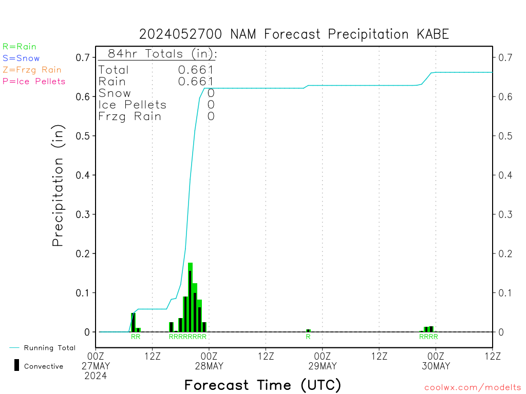
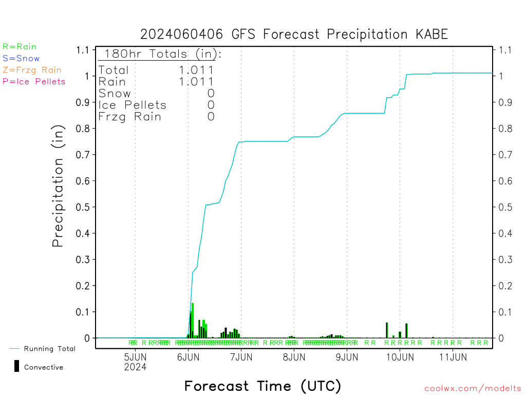
6Z NAM is VERY WET compmared to the GFS for my area.... plus GFS has some frozen precip.
Please register to post and access all features of our very popular forum. It is free and quick. Over $68,000 in prizes has already been given out to active posters on our forum. Additional giveaways are planned.
Detailed information about all U.S. cities, counties, and zip codes on our site: City-data.com.

 Please register to participate in our discussions with 2 million other members - it's free and quick! Some forums can only be seen by registered members. After you create your account, you'll be able to customize options and access all our 15,000 new posts/day with fewer ads.