Spring 2014 (March-May) - Northern Hemisphere (flood, NYC, Vermont, pressure)
Please register to participate in our discussions with 2 million other members - it's free and quick! Some forums can only be seen by registered members. After you create your account, you'll be able to customize options and access all our 15,000 new posts/day with fewer ads.
Latest EURO00z model has a prime storm track for interior but it's so juicy that even areas that get rain at first see a ton of snow. Check out the track and surface on left and the snow total results on right.
(Not a forecast, Not a Guarantee...Just a possibility)
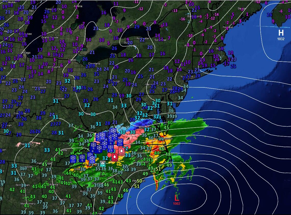
A look at the current Map with High near Nova Scotia, Low off North Carolina. I see 2-6" of snow has fallen in Virginia and North Carolina with 1/4" of ice in spots.
2" of snow and sleet in Greensboro, NC. Now over 128k Duke Energy customers w/o power
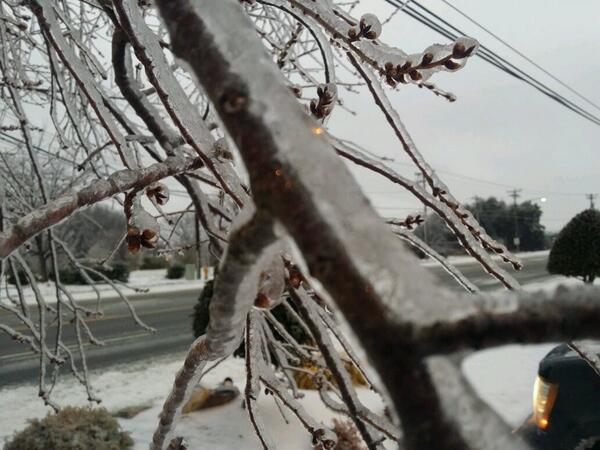
People are waking up and so the pictures are coming in now.
"1/2" of ice on this tree in Winston- Salem, NC. Over 200K without power due to the ice and some wind"
twitter.com/mikeseidel/status/441908851051216896
Burlington, NC "Davis and Front street whole tree is down and took down power pole"
Check out the data from that Euro for Danbury near me, Windsor Locks in northern CT and Islip on Long island.
It had about 3/4" of rain on Long island to 1/4" of snow.
but northern CT 1.66" of all snow (maybe some sleet to start).
Notice the 850 temps crash and notice the pressure and remember the storm track I showed above and why Long Island would be more rain.
Quote:
Originally Posted by Cambium
March 14, 2014 Snowstorm Update::
Latest EURO00z model has a prime storm track for interior but it's so juicy that even areas that get rain at first see a ton of snow. Check out the track and surface on left and the snow total results on right.
(Not a forecast, Not a Guarantee...Just a possibility)
Wow. And look how cold those 2 meter temperatures are too for the time of year. Great time for more cold air to return. Looks quite juicy indeed. Let's see how this changes in the coming days.
So far this month's average high and low are 29 F/10 F (-2 C/-12 C)...lowest minimum 0 F/-18 C. A few average days expected before going back below next week. Great start to March.
Snow finally stopped about 12:30 and we got about 2" here on the western side of the county while those on the eastern edge 25 miles away reported 3-4".
Since temps are expected to rise in to the mid 50's tomorrow I won't do more than clear off the back steps for the dogs.
Wow. And look how cold those 2 meter temperatures are too for the time of year. Great time for more cold air to return. Looks quite juicy indeed. Let's see how this changes in the coming days.
Yup.. and here's the new Euro just out.. Look where it places the low. Anyone south of NYC who doesn't want snow will love a track like this. North of NYC.. BOOM. Snowstorm...with wind
Here's the Data from that run for Atlantic City. 1.37" liquid. Surface and 850s above freezing until the very end. So all rain to maybe backside snow showers.
Danbury, CT just over the NY border. 1.29" liquid From this looks like the 5C afternoon temp might start the precip as liquid but its pretty much all snow after that..
so thats mean NJ might be spared the snow until the back end?
Please register to post and access all features of our very popular forum. It is free and quick. Over $68,000 in prizes has already been given out to active posters on our forum. Additional giveaways are planned.
Detailed information about all U.S. cities, counties, and zip codes on our site: City-data.com.

 Please register to participate in our discussions with 2 million other members - it's free and quick! Some forums can only be seen by registered members. After you create your account, you'll be able to customize options and access all our 15,000 new posts/day with fewer ads.


 Let's see how this changes in the coming days.


