Please register to participate in our discussions with 2 million other members - it's free and quick! Some forums can only be seen by registered members. After you create your account, you'll be able to customize options and access all our 15,000 new posts/day with fewer ads.
so thats mean NJ might be spared the snow until the back end?
Yeah, that's what that 1 run showed. There's going to be over 20 more updates until next week. We'll see.
I was looking at the soundings, even NYC stays all snow but Atlantic City is all rain before drying out at the end. So in the middle was the mix or backside snows.
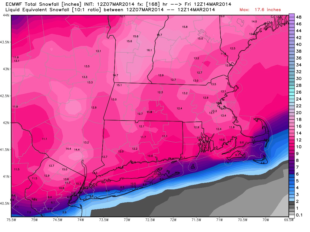
Albany, NY got crushed on the Euro. Over 1.25" qpf of all snow and higher than 10:1 ratios.
here's the snow total from that Euro update.
Like in Real Estate we say "location, location, location"?
Well...in weather we say. "Track, Track, Track". lol
Yup.. and here's the new Euro just out.. Look where it places the low.
Compare the Euro to the 12z Canadian. See the difference??? Canadian places the low over MA. So it goes through CT and MA which means it would be rain even up to southern Vermont and all of MA and CT.
HUGE DIFFERENCE by what.... 150 miles? maybe more. Sunday night we'll have better idea. Right now they are going to be all over the place.
Remember one always important thing.... the energy (Southern Stream and Polar Stream) are not even near the U.S right now. One is up in Canada, one is in the Pacific. Until they get closer models wont get the details right.
Something tells me they will be flying out either into the Pacific, Gulf or Atlantic to get more data for the models to ingest.
LOL well with that map i'm right on the cusp of pink and purple. I really dont want another snow day with the schools. Killing me!
pink and purple in NJ? Where about are you? The colors represent temps at 4000 feet. Blues or purples would support snow but as always have to look at surface too. And remember this is just one time frame. The Euro I posted was for Thursday 7am. The Canadian was Wednesday 7pm. (that means Euro is slower with the storm )
I was referring to this one when i said pink and purple. I'm in Essex County
Quote:
Originally Posted by Cambium
Yeah, that's what that 1 run showed. There's going to be over 20 more updates until next week. We'll see.
I was looking at the soundings, even NYC stays all snow but Atlantic City is all rain before drying out at the end. So in the middle was the mix or backside snows.
Albany, NY got crushed on the Euro. Over 1.25" qpf of all snow and higher than 10:1 ratios.
here's the snow total from that Euro update.
Like in Real Estate we say "location, location, location"?
Well...in weather we say. "Track, Track, Track". lol
I was referring to this one when i said pink and purple. I'm in Essex County
That's the Euro. Pink and Purple is up in Canada. Maybe you meant Blue and Purple. Anyway, yeah on the Euro is showing -2°C on that frame over you. You would get a lot of snow based on that run. Lets see what happens going forward.
THE POTENTIAL FOR A SIGNIFICANT WINTER STORM CONTINUES WED INTO
THU...BUT ITS NOT A CERTAINTY. KEEP IN MIND THAT THIS POTENTIAL
STORM IS STILL 5 TO 6 DAYS IN THE FUTURE...HENCE MODEL TRACK/PTYPE
AND QPF AMOUNTS ARE QUITE UNCERTAIN. ENSEMBLE SENSITIVITY PLOTS
SHOW THE MAIN PIECE OF ENERGY THAT CREATES THIS STORM IS STILL WELL
OUT IN THE PACIFIC...WHICH COMBINES WITH NORTHERN STREAM ENERGY
CURRENTLY LOCATED NEAR THE NORTH POLE. SO AS YOU CAN SEE...THERE
ARE A LOT OF MOVING PARTS TO THIS AND SUBTLE CHANGES IN THE
TIMING/STRENGTH AND INTERACTION BETWEEN THESE WAVES WILL HAVE A HUGE
IMPACT ON THE EVENTUAL OUTCOME.
AS WE TALKED ABOUT YESTERDAY...THERE ARE 3 MAIN POSSIBILITIES THAT
WE WILL DISCUSS. THE FIRST POSSIBILITY IS THAT THE TIMING/STRENGTH
OF THE ENERGY DOES NOT ALLOW THE TROUGH TO AMPLIFY ENOUGH. THIS
WOULD RESULT IN A GLANCING BLOW OR MISS FOR MOST OF SOUTHERN NEW
ENGLAND...AS LOW PRESSURE ESCAPES WELL TO OUR SOUTHEAST. THE SECOND
IS A STORM THAT AT LEAST PARTIALLY PHASES...ALLOWING FOR AN
INTENSIFYING COASTAL STORM TO TRACK NEAR OR INSIDE THE BENCHMARK.
THIS WOULD RESULT IN A SIGNIFICANT SNOWSTORM FOR MUCH OF SOUTHERN
NEW ENGLAND...WITH THE HEAVIEST FALLING ALONG THE COASTAL PLAIN.
THE THIRD IS A HIGHLY AMPLIFIED SOLUTION...WHICH ALLOWS THE LOW TO
HUG THE COAST. THIS WOULD BRING THE HEAVIEST SNOW TO PORTIONS OF
THE DISTANT INTERIOR...WHILE THE COASTAL PLAIN SEES SNOW CHANGING TO
SLEET AND RAIN.
ALL IN ALL...ITS JUST TOO EARLY TO BITE ON ANY PARTICULAR SOLUTION.
WE WOULD LIKE TO SEE THIS STORM GET INSIDE 96 HOURS TO HAVE MORE
CONFIDENCE IN ANY ONE SOLUTION. WE CAN SAY THAT THERE REMAINS THE
POTENTIAL FOR A SIGNIFICANT WINTER STORM. IF THIS DOES COME TO
FRUITION...THERE MAY BE THE NEED FOR WIND ADVISORIES ALONG THE
COAST. WE ARE FORTUNATE THAT ASTRONOMICAL HIGH TIDES ARE RATHER
LOW OVER THIS TIME. THE WORST CASE SCENARIO WOULD PROBABLY BE JUST
A ROUND OF MINOR COASTAL FLOODING/SPLASH OVER ALONG THE EASTERN MA
COAST ON THURSDAY.
FRIDAY...
WHAT EVER HAPPENS WITH THIS STORM...APPEARS THAT A SHOT OF COLD AIR
WILL FOLLOW IN ITS WAKE. HIGHS SHOULD MAINLY BE IN THE 30S TO CLOSE
OUT THE WORK WEEK.
THE POTENTIAL FOR A SIGNIFICANT WINTER STORM CONTINUES WED INTO
THU...BUT ITS NOT A CERTAINTY. KEEP IN MIND THAT THIS POTENTIAL
STORM IS STILL 5 TO 6 DAYS IN THE FUTURE...HENCE MODEL TRACK/PTYPE
AND QPF AMOUNTS ARE QUITE UNCERTAIN. ENSEMBLE SENSITIVITY PLOTS
SHOW THE MAIN PIECE OF ENERGY THAT CREATES THIS STORM IS STILL WELL
OUT IN THE PACIFIC...WHICH COMBINES WITH NORTHERN STREAM ENERGY
CURRENTLY LOCATED NEAR THE NORTH POLE. SO AS YOU CAN SEE...THERE
ARE A LOT OF MOVING PARTS TO THIS AND SUBTLE CHANGES IN THE TIMING/STRENGTH AND INTERACTION BETWEEN THESE WAVES WILL HAVE A HUGE IMPACT ON THE EVENTUAL OUTCOME.
AS WE TALKED ABOUT YESTERDAY...THERE ARE 3 MAIN POSSIBILITIES THAT
WE WILL DISCUSS. THE FIRST POSSIBILITY IS THAT THE TIMING/STRENGTH OF THE ENERGY DOES NOT ALLOW THE TROUGH TO AMPLIFY ENOUGH. THIS WOULD RESULT IN A GLANCING BLOW OR MISS FOR MOST OF SOUTHERN NEW ENGLAND AS LOW PRESSURE ESCAPES WELL TO OUR SOUTHEAST. THE SECOND IS A STORM THAT AT LEAST PARTIALLY PHASES...ALLOWING FOR AN INTENSIFYING COASTAL STORM TO TRACK NEAR OR INSIDE THE BENCHMARK. THIS WOULD RESULT IN A SIGNIFICANT SNOWSTORM FOR MUCH OF SOUTHERN NEW ENGLAND...WITH THE HEAVIEST FALLING ALONG THE COASTAL PLAIN. THE THIRD IS A HIGHLY AMPLIFIED SOLUTION...WHICH ALLOWS THE LOW TO HUG THE COAST. THIS WOULD BRING THE HEAVIEST SNOW TO PORTIONS OF THE DISTANT INTERIOR...WHILE THE COASTAL PLAIN SEES SNOW CHANGING TO SLEET AND RAIN.
Thanks! Pink bolded is the key in this.
The first scenario I bolded in black is out IMO. I don't see that happening based on consensus of models today.
The key is when the storms phase together... If too early or too strong the track wont favor the coast.
For a phase we look at the 500mb heights. Check out Bernies video
Please register to post and access all features of our very popular forum. It is free and quick. Over $68,000 in prizes has already been given out to active posters on our forum. Additional giveaways are planned.
Detailed information about all U.S. cities, counties, and zip codes on our site: City-data.com.

 Please register to participate in our discussions with 2 million other members - it's free and quick! Some forums can only be seen by registered members. After you create your account, you'll be able to customize options and access all our 15,000 new posts/day with fewer ads.