Property valuation of Co Rte 4, Cape Vincent, NY: 29902, 29919 (tax assessments)

Listed properties vs overall distribution of properties in Cape Vincent, NY:
Advertisements
Co Rte 4
Cape Vincent, NY
Find on map >>
Owner: Joseph A Martin & Aileen T Martin
Land assessed value: $46,600 (it was $22,800 in 2012)
Total assessed value for property: $46,600 (it was $22,800 in 2012)
Full market value: $46,600
Assessments for tax year: 2015
Property class: Abandoned ag
Land size: 5,180,590 square feet
Land types: Wasteland (66%), Tillable (30%), Residual (4%)
Neighborhood: Rural East
School District: Thousand Islands
Co Rte 4
Cape Vincent, NY
Find on map >>
Owner: Pamela Dougherty
Land assessed value: $54,000 (it was $22,000 in 2012)
Total assessed value for property: $54,000 (it was $22,000 in 2012)
Full market value: $54,000
Assessments for tax year: 2015
Property class: Priv forest
Land size: 9,583,200 square feet
Land types: Wetland (70%), Wasteland (18%), Woodland (11%)
Neighborhood: Rural East
School District: Thousand Islands
Co Rte 4
Cape Vincent, NY
Find on map >>
Owner: Vincent Town of Cape
Land assessed value: $2,800 (it was $1,400 in 2012)
Total assessed value for property: $2,800 (it was $1,400 in 2012)
Full market value: $2,800
Assessments for tax year: 2015
Property class: Abandoned ag
Land size: 601,128 square feet
Land types: Wasteland (100%)
Neighborhood: Rural East
School District: Thousand Islands
Co Rte 4
Cape Vincent, NY
Find on map >>
Owner: Lawrence Un Cemetery Assoc St
Land assessed value: $22,000 (it was $29,000 in 2012)
Improvements assessed value: $400 (it was $10,000 in 2012)
Total assessed value for property: $22,400 (it was $39,000 in 2012)
Full market value: $22,400
Assessments for tax year: 2015
Property class: Cemetery
Land size: 980,100 square feet
Land types: Wasteland (78%), Primary (22%)
Building style: Not Applicable
Neighborhood: Town Com
School District: Thousand Islands
Co Rte 4
Cape Vincent, NY
Find on map >>
Owner: Wallace Mcdowell
Land assessed value: $42,900 (it was $15,200 in 2012)
Total assessed value for property: $42,900 (it was $15,200 in 2012)
Full market value: $42,900
Assessments for tax year: 2015
Property class: Vac farmland
Land size: 3,346,279 square feet
Land types: Tillable (65%), Wasteland (35%)
Neighborhood: Rural East
School District: Thousand Islands
Co Rte 4
Cape Vincent, NY
Find on map >>
Owner: Randy J Lawrence
Land assessed value: $70,800 (it was $23,700 in 2012)
Total assessed value for property: $70,800 (it was $30,700 in 2012)
Full market value: $70,800
Assessments for tax year: 2015
Property class: Field crops
Land size: 4,913,568 square feet
Land types: Tillable (70%), Wasteland (19%), Woodland (11%)
Neighborhood: Rural East
School District: Thousand Islands
Co Rte 4
Cape Vincent, NY
Find on map >>
Owner: Faye Labarr
Land assessed value: $800 (it was $500 in 2012)
Total assessed value for property: $800 (it was $500 in 2012)
Full market value: $800
Assessments for tax year: 2015
Land size: 43,560 square feet
Land types: Undeveloped (100%)
Neighborhood: Rural East
School District: Thousand Islands
Co Rte 4
Cape Vincent, NY
Find on map >>
Owner: Wood Farms LLC
Land assessed value: $27,000 (it was $9,000 in 2012)
Total assessed value for property: $27,000 (it was $9,000 in 2012)
Full market value: $27,000
Assessments for tax year: 2015
Property class: Res vac land
Land size: 1,637,856 square feet
Land types: Tillable (100%)
Neighborhood: Rural East
School District: Thousand Islands
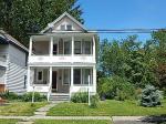
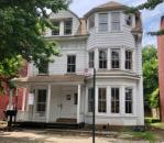
29902 Co Rte 4
Cape Vincent, NY
Find on map >>
Owner: David L Bonney & Janet M Bonney
Land assessed value: $61,700 (it was $26,700 in 2012)
Improvements assessed value: $100,800 (it was $75,900 in 2012)
Total assessed value for property: $162,500 (it was $102,600 in 2012)
Full market value: $162,500
Assessments for tax year: 2015
Property class: Rural res
Land size: 3,924,755 square feet
Land types: Wasteland (38%), Pasture (37%), Tillable (24%), Primary (1%)
Building style: Old style
Neighborhood: Rural West
School District: Thousand Islands
29919 Co Rte 4
Cape Vincent, NY
Find on map >>
Owner: Kevin Jackson & Pamela Jackson
Land assessed value: $19,100 (it was $14,300 in 2012)
Improvements assessed value: $26,300 (it was $13,100 in 2012)
Total assessed value for property: $45,400 (it was $27,400 in 2012)
Full market value: $45,400
Assessments for tax year: 2015
Property class: Auto dealer
Land size: 68,824 square feet
Land types: Leased Land (100%)
Neighborhood: Rural West
School District: Thousand Islands

Recent posts about Cape Vincent, New York on our local forum with over 2,400,000 registered users. Cape Vincent is mentioned 132 times on our forum:
 | What NY towns are most like Niagara-on-the-Lake (158 replies) |
| Good neighborhoods in Watertown NY?? (45 replies) |
| Vacation (20 replies) |
| From Long Island to the Burbs in Rochester...Help Please? (79 replies) |
| Upstate NY job openings...... (1432 replies) |
| any info on lowville please (31 replies) |
Settings
X

Recently Added Photos

Queens, NY
Wappinger, NY

Beacon, NY
Bronx, NY
Beacon, NY
Albany, NY

Staten Island, NY
Staten Island, NY
Staten Island, NY
Brooklyn, NY
Brooklyn, NY

Hyde Park, NY
Request disassociating your name from street-level assessment address

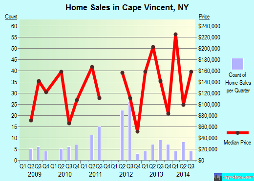
Recent home sales, price trends, and home value evaluator powered by Onboard Informatics
© 2024 Onboard Informatics. Information is deemed reliable but not guaranteed.
© 2024 Onboard Informatics. Information is deemed reliable but not guaranteed.
Some parts © 2024 Advameg, Inc.
Compilation, repackaging, or reproduction prohibited. Users are forewarned that it is incumbent upon them to verify information with the responsible state agency. Advameg, Inc. does not guarantee the data presented is up-to-date nor does it assume responsibility for updating it. Therefore any names, owners or addresses may have changed. Use of any information published here to contact the persons might be prohibited by the law.