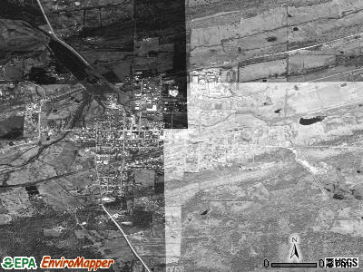
Mansfield, Arkansas
Submit your own pictures of this city and show them to the world
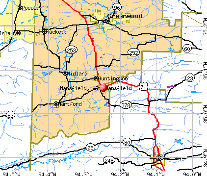
- OSM Map
- General Map
- Google Map
- MSN Map
Population change since 2000: -4.3%
 |
| Males: 530 | |
| Females: 520 |
| Median resident age: | 40.5 years |
| Arkansas median age: | 38.9 years |
Zip codes: 72944.
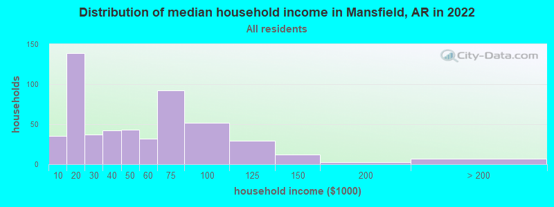
| Mansfield: | $41,190 |
| AR: | $55,432 |
Estimated per capita income in 2022: $20,615 (it was $13,012 in 2000)
Mansfield city income, earnings, and wages data
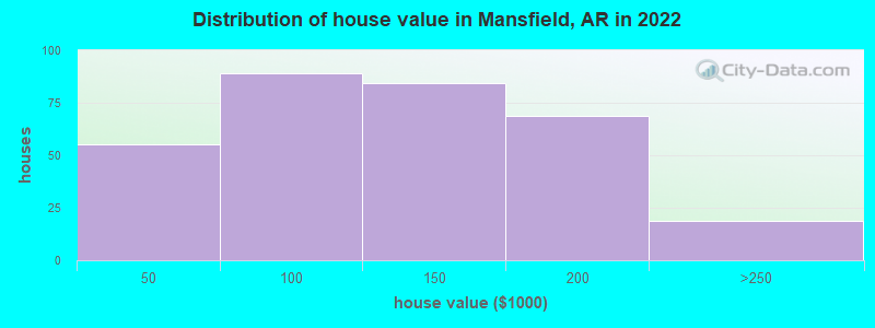
Estimated median house or condo value in 2022: $113,021 (it was $46,900 in 2000)
| Mansfield: | $113,021 |
| AR: | $179,800 |
Mean prices in 2022: all housing units: $116,409; detached houses: $122,807; townhouses or other attached units: $182,790; mobile homes: $7,940
Median gross rent in 2022: $695.
(28.4% for White Non-Hispanic residents, 18.2% for Hispanic or Latino residents, 18.2% for American Indian residents, 100.0% for other race residents, 30.0% for two or more races residents)
Detailed information about poverty and poor residents in Mansfield, AR
Compare current foreclosures near Mansfield, AR:
| Photo | Address | Area | Beds / Baths | Price | Details |
|---|---|---|---|---|---|

|
#1
Marit St
Mansfield, AR 72944
|
1,682 sq. feet
|
2 baths - beds |
show details | |

|
#2
E Willis St
Mansfield, AR 72944
|
1,282 sq. feet
|
1 baths - beds |
show details | |

|
#3
Fairfax St
Mansfield, AR 72944
|
- sq. feet
|
- baths - beds |
show details | |

|
#4
Fairfax St
Mansfield, AR 72944
|
- sq. feet
|
- baths - beds |
show details | |

|
#5
W Highway 28
Waldron, AR 72958
|
1,664 sq. feet
|
2 baths 3 beds |
$34,900
|
show details |

|
#6
N Ulmer St
Greenwood, AR 72936
|
- sq. feet
|
2 baths 4 beds |
show details | |

|
#7
Hidden Valley Way
Greenwood, AR 72936
|
- sq. feet
|
2 baths 4 beds |
show details | |

|
#8
Pecan Ln
Greenwood, AR 72936
|
1,568 sq. feet
|
2 baths - beds |
show details | |

|
#9
Hallelujah Ranch Rd
Poteau, OK 74953
|
1,802 sq. feet
|
2 baths 3 beds |
show details | |

|
#10
Bear Hollow Rd
Fort Smith, AR 72916
|
2,307 sq. feet
|
2 baths - beds |
show details |
| Photo | Address | Area | Beds / Baths | Price | Details |
|---|---|---|---|---|---|

|
#11
Bridges Ln
Greenwood, AR 72936
|
1,488 sq. feet
|
2 baths - beds |
show details | |

|
#12
Bear Claw Trl
Fort Smith, AR 72916
|
1,352 sq. feet
|
1 baths - beds |
show details | |

|
#13
Barber Rd
Booneville, AR 72927
|
1,216 sq. feet
|
1 baths - beds |
show details | |

|
#14
Randell St
Waldron, AR 72958
|
1,246 sq. feet
|
1 baths - beds |
show details | |

|
#15
Spruce St
Greenwood, AR 72936
|
1,460 sq. feet
|
2 baths - beds |
show details | |

|
#16
Tate Rd
Booneville, AR 72927
|
1,542 sq. feet
|
1 baths - beds |
show details | |

|
#17
Tennessee Ridge Rd
Fort Smith, AR 72916
|
2,529 sq. feet
|
2 baths - beds |
show details | |

|
#18
Easley Loop
Greenwood, AR 72936
|
1,074 sq. feet
|
1 baths - beds |
show details | |

|
#19
Chippewa Trl
Greenwood, AR 72936
|
1,195 sq. feet
|
1 baths - beds |
show details | |

|
#20
Grand Brook Dr
Greenwood, AR 72936
|
1,154 sq. feet
|
1 baths - beds |
show details |
| Photo | Address | Area | Beds / Baths | Price | Details |
|---|---|---|---|---|---|

|
#21
Plumbark Ct
Greenwood, AR 72936
|
1,333 sq. feet
|
2 baths - beds |
show details | |

|
#22
Plumbark Dr
Greenwood, AR 72936
|
1,120 sq. feet
|
2 baths - beds |
show details | |

|
#23
W Highway 28
Waldron, AR 72958
|
2,400 sq. feet
|
2 baths - beds |
show details | |

|
#24
E Center St
Greenwood, AR 72936
|
1,075 sq. feet
|
1 baths - beds |
show details | |

|
#25
Dayton Rd
Huntington, AR 72940
|
1,242 sq. feet
|
1 baths - beds |
show details | |

|
#26
Southshore Dr
Hackett, AR 72937
|
1,586 sq. feet
|
1 baths - beds |
show details | |

|
#27
Fox Trot Ct
Hartford, AR 72938
|
1,794 sq. feet
|
2 baths - beds |
show details | |

|
#28
E Main St
Hartford, AR 72938
|
- sq. feet
|
- baths - beds |
show details | |

|
#29
Chad Colley Blvd # 2702
Fort Smith, AR 72916
|
- sq. feet
|
- baths - beds |
show details | |

|
#30
Chad Colley Blvd # 3406
Fort Smith, AR 72916
|
- sq. feet
|
- baths - beds |
show details |
| Photo | Address | Area | Beds / Baths | Price | Details |
|---|---|---|---|---|---|

|
#31
Glenview Ct
Fort Smith, AR 72916
|
- sq. feet
|
- baths - beds |
show details | |

|
#32
Candy Ln # A
Fort Smith, AR 72916
|
- sq. feet
|
- baths - beds |
show details | |

|
#33
E 1st St
Waldron, AR 72958
|
- sq. feet
|
- baths - beds |
show details | |

|
#34
Nickletown Rd
Huntington, AR 72940
|
- sq. feet
|
- baths - beds |
show details | |

|
#35
Freedom Rd
Booneville, AR 72927
|
- sq. feet
|
- baths - beds |
show details | |

|
#36
Pottridge Ln
Waldron, AR 72958
|
- sq. feet
|
- baths - beds |
show details | |

|
#37
Honeysuckle Ln
Greenwood, AR 72936
|
- sq. feet
|
- baths - beds |
show details | |

|
#38
E Spradling St
Hartford, AR 72938
|
- sq. feet
|
- baths - beds |
show details | |

|
#39
E Highway 10
Greenwood, AR 72936
|
- sq. feet
|
- baths - beds |
show details | |

|
#40
Forrest Park Way
Greenwood, AR 72936
|
- sq. feet
|
- baths - beds |
show details |
| Photo | Address | Area | Beds / Baths | Price | Details |
|---|---|---|---|---|---|

|
#41
W Houston St # A
Greenwood, AR 72936
|
- sq. feet
|
- baths - beds |
show details | |

|
#42
Grimes St
Greenwood, AR 72936
|
- sq. feet
|
- baths - beds |
show details | |

|
#43
Brighton Pl
Greenwood, AR 72936
|
- sq. feet
|
- baths - beds |
show details | |

|
#44
Chad Colley Blvd # 4108
Fort Smith, AR 72916
|
- sq. feet
|
- baths - beds |
show details | |

|
#45
Old Jenny Lind Loop
Fort Smith, AR 72916
|
- sq. feet
|
- baths - beds |
show details | |

|
#46
Boone Rd
Greenwood, AR 72936
|
- sq. feet
|
- baths - beds |
show details | |

|
#47
Cedar St
Waldron, AR 72958
|
- sq. feet
|
- baths - beds |
show details | |

|
#48
Stroud Rd
Greenwood, AR 72936
|
- sq. feet
|
- baths - beds |
show details | |

|
#49
Southshore Dr
Hackett, AR 72937
|
- sq. feet
|
- baths - beds |
show details | |

|
Check over 1 million property listings on Foreclosure.com!
|
browse all offers | |||


- 1,10782.9%White alone
- 22016.5%Two or more races
- 231.7%Hispanic
- 131.0%American Indian alone
- 20.1%Other race alone

According to our research of Arkansas and other state lists, there were 5 registered sex offenders living in Mansfield, Arkansas as of May 24, 2024.
The ratio of all residents to sex offenders in Mansfield is 290 to 1.
Type |
2019 |
2020 |
2021 |
2022 |
|---|---|---|---|---|
| Murders (per 100,000) | 1 (90.8) | 0 (0.0) | 0 (0.0) | 0 (0.0) |
| Rapes (per 100,000) | 1 (90.8) | 0 (0.0) | 0 (0.0) | 0 (0.0) |
| Robberies (per 100,000) | 0 (0.0) | 0 (0.0) | 0 (0.0) | 0 (0.0) |
| Assaults (per 100,000) | 0 (0.0) | 8 (733.9) | 1 (92.3) | 4 (377.0) |
| Burglaries (per 100,000) | 3 (272.5) | 4 (367.0) | 2 (184.7) | 3 (282.8) |
| Thefts (per 100,000) | 8 (726.6) | 10 (917.4) | 6 (554.0) | 11 (1,037) |
| Auto thefts (per 100,000) | 2 (181.7) | 1 (91.7) | 3 (277.0) | 1 (94.3) |
| Arson (per 100,000) | 1 (90.8) | 0 (0.0) | 1 (92.3) | 0 (0.0) |
| City-Data.com crime index | 317.0 | 216.5 | 75.7 | 144.2 |
The City-Data.com crime index weighs serious crimes and violent crimes more heavily. Higher means more crime, U.S. average is 246.1. It adjusts for the number of visitors and daily workers commuting into cities.

Crime rate in Mansfield detailed stats: murders, rapes, robberies, assaults, burglaries, thefts, arson
Full-time law enforcement employees in 2021, including police officers: 4 (4 officers - 3 male; 1 female).
| Officers per 1,000 residents here: | 3.69 |
| Arkansas average: | 2.25 |
 Recent articles from our blog. Our writers, many of them Ph.D. graduates or candidates, create easy-to-read articles on a wide variety of topics.

 | Best driving route from NWA to Texarkana (7 replies) |
| Help me please!!!!!! (40 replies) |
| Warnings Before You Move To Fort Smith, Arkansas (145 replies) |
| Mansfield Property Management...NW AR (0 replies) |
| Want a new life, is Arkansas the place to live? (83 replies) |
| Ozark & Booneville-what are they like? (14 replies) |
Latest news from Mansfield, AR collected exclusively by city-data.com from local newspapers, TV, and radio stations
Ancestries: American (8.8%), German (6.8%), English (5.2%), Irish (4.8%), Italian (2.1%), Dutch (1.2%).
Current Local Time: CST time zone
Elevation: 612 feet
Land area: 2.22 square miles.
Population density: 472 people per square mile (low).
31 residents are foreign born (1.5% Europe, 1.1% Latin America).
| This city: | 2.8% |
| Arkansas: | 2.8% |
Median real estate property taxes paid for housing units with mortgages in 2022: $651 (0.5%)
Median real estate property taxes paid for housing units with no mortgage in 2022: $448 (0.5%)
Nearest city with pop. 50,000+: Fort Smith, AR  (23.1 miles , pop. 80,268).
Nearest city with pop. 200,000+: Tulsa, OK (120.6 miles , pop. 393,049).
Nearest city with pop. 1,000,000+: Dallas, TX (213.7 miles , pop. 1,188,580).
Nearest cities:
), ), ), )Latitude: 35.06 N, Longitude: 94.25 W
Area code: 479
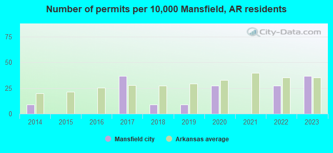
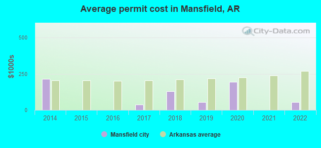
Single-family new house construction building permits:
- 2022: 3 buildings, average cost: $55,000
- 2020: 3 buildings, average cost: $192,700
- 2019: 1 building, cost: $55,000
- 2018: 1 building, cost: $127,600
- 2017: 4 buildings, average cost: $37,500
- 2014: 1 building, cost: $212,800
| Here: | 3.7% |
| Arkansas: | 3.4% |
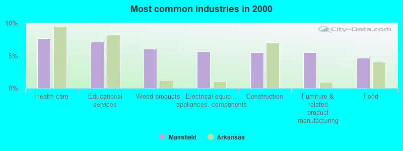
- Health care (7.7%)
- Educational services (7.1%)
- Wood products (6.1%)
- Electrical equipment, appliances, components (5.7%)
- Construction (5.5%)
- Furniture & related product manufacturing (5.5%)
- Food (4.7%)
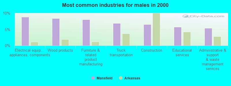
- Electrical equipment, appliances, components (8.8%)
- Wood products (8.4%)
- Furniture & related product manufacturing (8.0%)
- Truck transportation (6.9%)
- Construction (6.5%)
- Educational services (5.7%)
- Administrative & support & waste management services (5.4%)
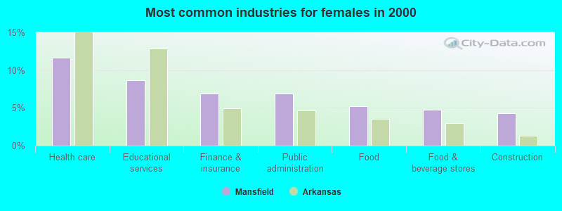
- Health care (11.6%)
- Educational services (8.6%)
- Finance & insurance (6.9%)
- Public administration (6.9%)
- Food (5.2%)
- Food & beverage stores (4.7%)
- Construction (4.3%)
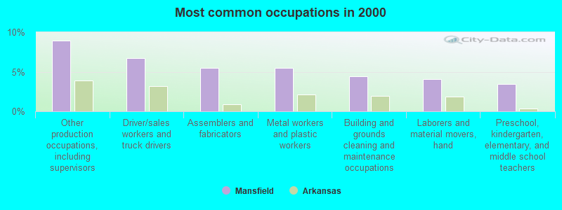
- Other production occupations, including supervisors (8.9%)
- Driver/sales workers and truck drivers (6.7%)
- Assemblers and fabricators (5.5%)
- Metal workers and plastic workers (5.5%)
- Building and grounds cleaning and maintenance occupations (4.5%)
- Laborers and material movers, hand (4.1%)
- Preschool, kindergarten, elementary, and middle school teachers (3.4%)
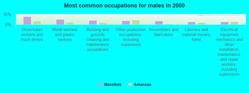
- Driver/sales workers and truck drivers (12.6%)
- Metal workers and plastic workers (8.4%)
- Building and grounds cleaning and maintenance occupations (6.9%)
- Other production occupations, including supervisors (6.1%)
- Assemblers and fabricators (5.7%)
- Laborers and material movers, hand (4.6%)
- Electrical equipment mechanics and other installation, maintenance, and repair workers, including supervisors (4.2%)
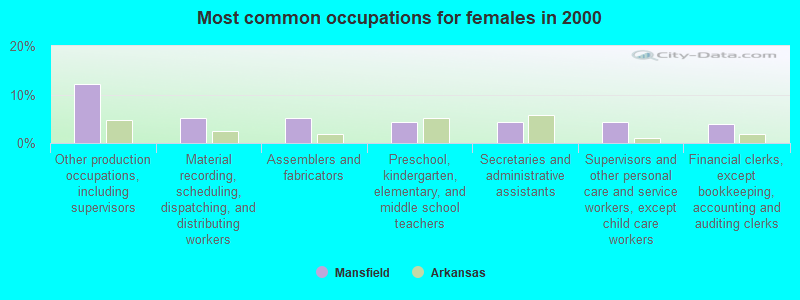
- Other production occupations, including supervisors (12.1%)
- Material recording, scheduling, dispatching, and distributing workers (5.2%)
- Assemblers and fabricators (5.2%)
- Preschool, kindergarten, elementary, and middle school teachers (4.3%)
- Secretaries and administrative assistants (4.3%)
- Supervisors and other personal care and service workers, except child care workers (4.3%)
- Financial clerks, except bookkeeping, accounting and auditing clerks (3.9%)
Average climate in Mansfield, Arkansas
Based on data reported by over 4,000 weather stations


|
|


Tornado activity:
Mansfield-area historical tornado activity is slightly below Arkansas state average. It is 66% greater than the overall U.S. average.
On 3/26/1976, a category F5 (max. wind speeds 261-318 mph) tornado 19.5 miles away from the Mansfield city center killed 2 people and injured 64 people and caused between $500,000 and $5,000,000 in damages.
On 4/19/1968, a category F4 (max. wind speeds 207-260 mph) tornado 9.8 miles away from the city center killed 14 people and injured 270 people and caused between $500,000 and $5,000,000 in damages.
Earthquake activity:
Mansfield-area historical earthquake activity is significantly above Arkansas state average. It is 599% greater than the overall U.S. average.On 11/6/2011 at 03:53:10, a magnitude 5.7 (5.7 MW, Depth: 3.2 mi, Class: Moderate, Intensity: VI - VII) earthquake occurred 145.9 miles away from Mansfield center
On 9/3/2016 at 12:02:44, a magnitude 5.8 (5.8 MW, Depth: 3.5 mi) earthquake occurred 177.8 miles away from Mansfield center
On 11/7/2016 at 01:44:24, a magnitude 5.0 (5.0 MW, Depth: 2.8 mi) earthquake occurred 157.7 miles away from the city center
On 2/28/2011 at 05:00:50, a magnitude 4.7 (4.7 MW, Depth: 2.0 mi, Class: Light, Intensity: IV - V) earthquake occurred 107.9 miles away from the city center
On 1/21/1982 at 00:33:54, a magnitude 4.7 (4.5 MB, 4.7 LG, 4.5 LG) earthquake occurred 115.6 miles away from Mansfield center
On 5/4/2001 at 06:42:12, a magnitude 4.7 (4.2 MB, 4.7 LG, 4.5 LG) earthquake occurred 116.5 miles away from the city center
Magnitude types: regional Lg-wave magnitude (LG), body-wave magnitude (MB), moment magnitude (MW)
Natural disasters:
The number of natural disasters in Sebastian County (16) is near the US average (15).Major Disasters (Presidential) Declared: 10
Emergencies Declared: 4
Causes of natural disasters: Storms: 9, Floods: 7, Tornadoes: 6, Winter Storms: 4, Winds: 2, Drought: 1, Hurricane: 1, Other: 1 (Note: some incidents may be assigned to more than one category).
Colleges/universities with over 2000 students nearest to Mansfield:
- Carl Albert State College (about 22 miles; Poteau, OK; Full-time enrollment: 2,041)
- University of Arkansas-Fort Smith (about 24 miles; Fort Smith, AR; FT enrollment: 6,103)
- Arkansas Tech University (about 66 miles; Russellville, AR; FT enrollment: 9,038)
- University of Arkansas (about 70 miles; Fayetteville, AR; FT enrollment: 22,163)
- Northeastern State University (about 73 miles; Tahlequah, OK; FT enrollment: 6,895)
- National Park Community College (about 75 miles; Hot Springs, AR; FT enrollment: 2,237)
- John Brown University (about 81 miles; Siloam Springs, AR; FT enrollment: 2,097)
Public high schools in Mansfield:
- MANSFIELD JTC SCHOOL (Location: 36 JOHNNY CAKE POINT RD, Grades: 8-12)
- MANSFIELD HIGH SCHOOL (Location: 2500 HWY 71 S, Grades: 9-12)
Public elementary/middle schools in Mansfield:
- MANSFIELD ELEMENTARY SCHOOL (Location: 100 N WALNUT AVE, Grades: KG-4)
- MANSFIELD MIDDLE SCHOOL (Location: 400 GROVE ST, Grades: 5-8)
Points of interest:
Notable locations in Mansfield: Mansfield Police Department (A), Mansfield Fire Station (B). Display/hide their locations on the map
Church in Mansfield: Coop Prairie Cumberland Presbyterian Church (A). Display/hide its location on the map
Cemetery: Coop Prairie Cemetery (1). Display/hide its location on the map
Creek: Coop Creek (A). Display/hide its location on the map
Park in Mansfield: Johnny Cake Park (1). Display/hide its location on the map
Drinking water stations with addresses in Mansfield and their reported violations in the past:
MANSFIELD WATERWORKS (Population served: 2,313, Purch surface water):Past monitoring violations:
- 2 minor monitoring violations
| This city: | 2.5 people |
| Arkansas: | 2.5 people |
| This city: | 67.3% |
| Whole state: | 67.6% |
| This city: | 6.9% |
| Whole state: | 5.7% |
Likely homosexual households (counted as self-reported same-sex unmarried-partner households)
- Lesbian couples: 1.3% of all households
- Gay men: 0.2% of all households
Banks with branches in Mansfield (2011 data):
- Farmers Bank: Mansfield Branch at Huntington Ave. And Hwy 96, branch established on 2004/10/04. Info updated 2006/07/26: Bank assets: $183.9 mil, Deposits: $144.2 mil, headquarters in Greenwood, AR, positive income, 11 total offices, Holding Company: Wilkinson Banking Corporation
- Allied Bank: Mansfield Branch at 101 S Seba Scott Ave, branch established on 1901/01/01. Info updated 2006/11/03: Bank assets: $174.5 mil, Deposits: $144.9 mil, headquarters in Mulberry, AR, negative income in the last year, Commercial Lending Specialization, 10 total offices, Holding Company: Acme Holding Company Inc. Employee Stock Ownership Plan
- Chambers Bank: Mansfield Branch at Highway 96, branch established on 1990/12/26. Info updated 2008/12/08: Bank assets: $711.4 mil, Deposits: $589.0 mil, headquarters in Danville, AR, negative income in the last year, Commercial Lending Specialization, 20 total offices, Holding Company: Chambers Bancshares, Inc.
For population 15 years and over in Mansfield:
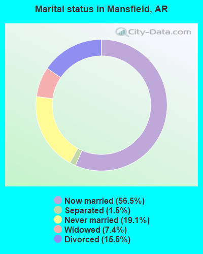
- Never married: 19.1%
- Now married: 56.5%
- Separated: 1.5%
- Widowed: 7.4%
- Divorced: 15.5%
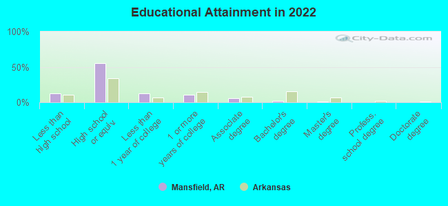
For population 25 years and over in Mansfield:
- High school or higher: 85.5%
- Bachelor's degree or higher: 4.1%
- Graduate or professional degree: 1.8%
- Unemployed: 3.0%
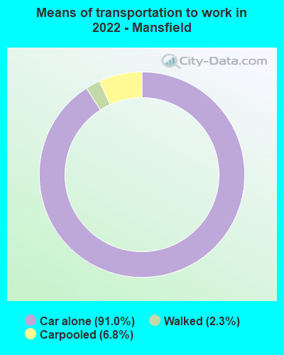
- Mean travel time to work (commute): 27.4 minutes
| Here: | 7.6 |
| Arkansas average: | 11.4 |

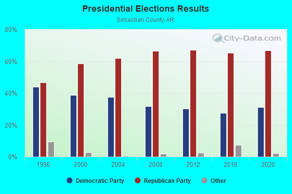
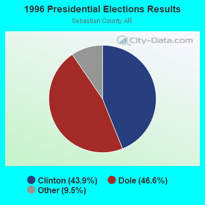
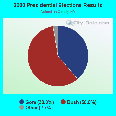
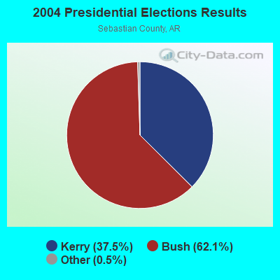

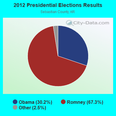
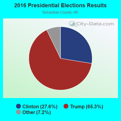
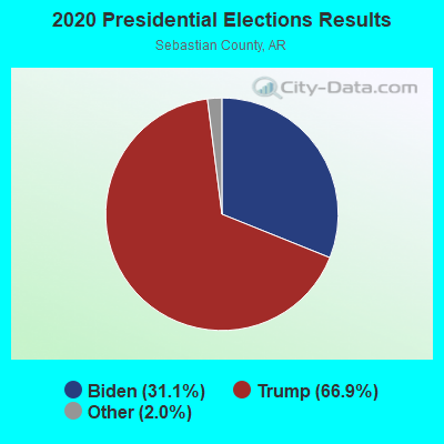
Graphs represent county-level data. Detailed 2008 Election Results
Religion statistics for Mansfield, AR (based on Sebastian County data)
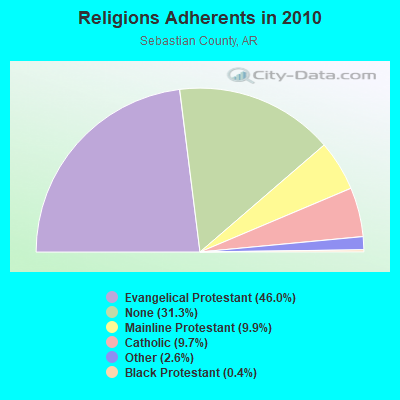
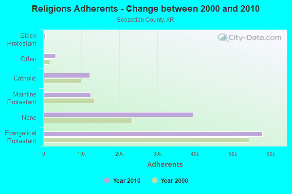
| Religion | Adherents | Congregations |
|---|---|---|
| Evangelical Protestant | 57,844 | 157 |
| Mainline Protestant | 12,423 | 34 |
| Catholic | 12,251 | 6 |
| Other | 3,241 | 13 |
| Black Protestant | 555 | 4 |
| Orthodox | 60 | 1 |
| None | 39,370 | - |
Food Environment Statistics:
| Here: | 1.65 / 10,000 pop. |
| Arkansas: | 2.02 / 10,000 pop. |
| Sebastian County: | 0.33 / 10,000 pop. |
| Arkansas: | 0.25 / 10,000 pop. |
| Sebastian County: | 0.74 / 10,000 pop. |
| State: | 0.59 / 10,000 pop. |
| This county: | 5.27 / 10,000 pop. |
| Arkansas: | 4.94 / 10,000 pop. |
| Sebastian County: | 8.57 / 10,000 pop. |
| Arkansas: | 6.66 / 10,000 pop. |
| Here: | 10.1% |
| Arkansas: | 9.8% |
| Here: | 27.8% |
| State: | 29.1% |
| Sebastian County: | 19.1% |
| Arkansas: | 13.6% |
Health and Nutrition:
| Mansfield: | 49.9% |
| Arkansas: | 48.2% |
| Here: | 48.5% |
| Arkansas: | 44.2% |
| Here: | 29.6 |
| Arkansas: | 28.9 |
| Mansfield: | 20.3% |
| Arkansas: | 21.6% |
| This city: | 10.3% |
| Arkansas: | 11.3% |
| This city: | 7.1 |
| State: | 6.8 |
| Mansfield: | 38.7% |
| Arkansas: | 34.0% |
| Mansfield: | 55.8% |
| Arkansas: | 54.4% |
| Mansfield: | 79.8% |
| Arkansas: | 78.0% |
More about Health and Nutrition of Mansfield, AR Residents
| Local government employment and payroll (March 2022) | |||||
| Function | Full-time employees | Monthly full-time payroll | Average yearly full-time wage | Part-time employees | Monthly part-time payroll |
|---|---|---|---|---|---|
| Police Protection - Officers | 4 | $11,315 | $33,945 | 0 | $0 |
| Other and Unallocable | 2 | $6,063 | $36,378 | 1 | $1,572 |
| Solid Waste Management | 2 | $5,744 | $34,464 | 3 | $3,773 |
| Other Government Administration | 2 | $6,023 | $36,138 | 0 | $0 |
| Sewerage | 1 | $3,321 | $39,852 | 0 | $0 |
| Water Supply | 1 | $2,923 | $35,076 | 0 | $0 |
| Financial Administration | 1 | $3,716 | $44,592 | 0 | $0 |
| Totals for Government | 13 | $39,104 | $36,096 | 4 | $5,345 |
Mansfield government finances - Expenditure in 2017 (per resident):
- Current Operations - Water Utilities: $573,000 ($545.71)
General - Other: $504,000 ($480.00)
Sewerage: $146,000 ($139.05)
Regular Highways: $75,000 ($71.43)
Central Staff Services: $13,000 ($12.38)
Parks and Recreation: $1,000 ($0.95)
- Other Capital Outlay - Regular Highways: $12,000 ($11.43)
General - Other: $7,000 ($6.67)
- Total Salaries and Wages: $468,000 ($445.71)
- Water Utilities - Interest on Debt: $142,000 ($135.24)
Mansfield government finances - Revenue in 2017 (per resident):
- Charges - Other: $59,000 ($56.19)
Sewerage: $3,000 ($2.86)
- Miscellaneous - General Revenue - Other: $69,000 ($65.71)
- Revenue - Water Utilities: $773,000 ($736.19)
- State Intergovernmental - Highways: $75,000 ($71.43)
Other: $18,000 ($17.14)
- Tax - General Sales and Gross Receipts: $515,000 ($490.48)
Property: $67,000 ($63.81)
Public Utilities Sales: $46,000 ($43.81)
Other License: $3,000 ($2.86)
Mansfield government finances - Debt in 2017 (per resident):
- Long Term Debt - Beginning Outstanding - Unspecified Public Purpose: $3,542,000 ($3373.33)
Outstanding Unspecified Public Purpose: $3,413,000 ($3250.48)
Retired Unspecified Public Purpose: $129,000 ($122.86)
Mansfield government finances - Cash and Securities in 2017 (per resident):
- Other Funds - Cash and Securities: $697,000 ($663.81)
Businesses in Mansfield, AR
- SONIC Drive-In: 1
- UPS: 1
Strongest AM radio stations in Mansfield:
- KYHN (1320 AM; 10 kW; FORT SMITH, AR; Owner: CAPSTAR TX LIMITED PARTNERSHIP)
- KWHN (1650 AM; 10 kW; FT. SMITH, AR; Owner: CAPSTAR TX LIMITED PARTNERSHIP)
- KGHT (880 AM; 50 kW; SHERIDAN, AR; Owner: METROPOLITAN RADIO GROUP, INC.)
- KRMG (740 AM; 50 kW; TULSA, OK; Owner: CXR HOLDINGS, INC.)
- KAAY (1090 AM; 50 kW; LITTLE ROCK, AR; Owner: CITADEL BROADCASTING COMPANY)
- KFAQ (1170 AM; 50 kW; TULSA, OK; Owner: JOURNAL BROADCAST CORPORATION)
- KTCS (1410 AM; 1 kW; FORT SMITH, AR; Owner: BIG CHIEF BROADCASTING CO.)
- KEEL (710 AM; 50 kW; SHREVEPORT, LA; Owner: CITICASTERS LICENSES, L.P.)
- KFAY (1030 AM; 10 kW; FARMINGTON, AR; Owner: CUMULUS LICENSING CORP)
- KWXI (670 AM; daytime; 5 kW; GLENWOOD, AR; Owner: PGR COMMUNICATIONS, INC.)
- KWKH (1130 AM; 50 kW; SHREVEPORT, LA; Owner: CITICASTERS LICENSES, L.P.)
- KFPW (1230 AM; 1 kW; FORT SMITH, AR; Owner: PHARIS BROADCASTING, INC.)
- KPRV (1280 AM; 1 kW; POTEAU, OK; Owner: LEROY BILLY)
Strongest FM radio stations in Mansfield:
- KOMS (107.3 FM; POTEAU, OK; Owner: CUMULUS LICENSING CORP.)
- KRWA-FM (103.1 FM; WALDRON, AR; Owner: PHARIS BROADCASTING, INC.)
- KZBB (97.9 FM; POTEAU, OK; Owner: CAPSTAR TX LIMITED PARTNERSHIP)
- KMAG (99.1 FM; FORT SMITH, AR; Owner: CAPSTAR TX LIMITED PARTNERSHIP)
- KTCS-FM (99.9 FM; FORT SMITH, AR; Owner: BIG CHIEF BROADCASTING COMPANY)
- K204EW (88.7 FM; POTEAU, OK; Owner: CALVARY CHAPEL OF TWIN FALLS, INC.)
- K219CN (91.7 FM; POTEAU, OK; Owner: AMERICAN FAMILY ASSOCIATION)
- KARG (91.7 FM; POTEAU, OK; Owner: AMERICAN FAMILY ASSOCIATION)
- K207CW (89.3 FM; PARIS, AR; Owner: CALVARY CHAPEL OF TWIN FALLS, INC.)
- KRBK (104.7 FM; BOONEVILLE, AR; Owner: PHARIS BROADCASTING, INC,)
- KZKZ-FM (106.3 FM; GREENWOOD, AR; Owner: FAMILY COMMUNICATIONS, INC.)
- KBBQ-FM (100.7 FM; FORT SMITH, AR; Owner: CUMULUS LICENSING CORP.)
- KKRI (88.1 FM; POCOLA, OK; Owner: EDUCATIONAL MEDIA FOUNDATION)
- KTTG (96.3 FM; MENA, AR; Owner: PEARSON BROADCASTING OF MENA, INC.)
- KISR (93.7 FM; FORT SMITH, AR; Owner: STEREO 93, INC.)
- KOLX (94.5 FM; BARLING, AR; Owner: PHARIS BROADCASTING, INC.)
- KERX (95.3 FM; PARIS, AR; Owner: PEARSON BROADCASTING OF PARIS, INC.)
- KLSZ-FM (102.7 FM; VAN BUREN, AR; Owner: CUMULUS LICENSING CORP.)
- KPRV-FM (92.5 FM; HEAVENER, OK; Owner: LEROY BILLY)
- KREU (92.3 FM; ROLAND, OK; Owner: STAR 92 CO.)
TV broadcast stations around Mansfield:
- KFSM-TV (Channel 5; FORT SMITH, AR; Owner: NEW YORK TIMES MANAGEMENT SERVICES)
- K59GJ (Channel 59; POTEAU, OK; Owner: FORT SMITH 46, INC.)
Mansfield fatal accident list:
Apr 24, 2011 02:31 AM, Dayton Rd, Lat: 35.151706, Lon: -94.284658, Vehicles: 1, Persons: 1, Fatalities: 1
Jul 3, 2009 06:08 PM, Us-71-12, Dayton Rd, Lat: 35.067239, Lon: -94.228106, Vehicles: 2, Persons: 4, Fatalities: 1
- National Bridge Inventory (NBI) Statistics
- 26Number of bridges
- 154ft / 47.1mTotal length
- $2,628,000Total costs
- 25,160Total average daily traffic
- 1,755Total average daily truck traffic
- 31,810Total future (year 2005) average daily traffic
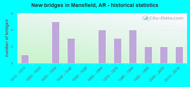
- New bridges - historical statistics
- 11910-1919
- 51930-1939
- 31940-1949
- 41960-1969
- 31970-1979
- 41980-1989
- 21990-1999
- 22000-2009
- 22010-2019
FCC Registered Antenna Towers:
1- Christophe Le Scanve, 20456 Hwy 71 N (Lat: 35.062833 Lon: -94.152500), Type: 81.7, Structure height: 05127 m, Overall height: 77.7 m, Registrant: Alltel Corporation, Network.Regulatory@verizonwireless.Com, Np2ne Network Engineering, Alpha-retta, Phone: (770) 797-1070
FCC Registered Microwave Towers:
3- Mansfield, Lat: 35.021194 Lon: -94.202111, Call Sign: WPYW747, Licensee ID: L00546750,
Assigned Frequencies: 956.381 MHz, Grant Date: 11/18/2003, Expiration Date: 11/18/2013, Cancellation Date: 01/18/2014, Certifier: Glen Hurt, Registrant: City Of Mansfield
- MANSFIELD, 824 East Willis Street (Lat: 35.067972 Lon: -94.243417), Type: Gtower, Structure height: 91.4 m, Overall height: 97.5 m, Call Sign: WQQM533,
Assigned Frequencies: 11345.0 MHz, 11345.0 MHz, 11345.0 MHz, 11345.0 MHz, Grant Date: 02/28/2023, Expiration Date: 01/28/2033, Certifier: Chris Harris, Registrant: Conterra Ultra Broadband LLC, 2101 Rexford Rd, Ste 200e, Charlotte, NC 28211, Phone: (704) 936-1801, Email:
- AR01529B, 824 East Willis Street (Lat: 35.067972 Lon: -94.243417), Type: Gtower, Structure height: 91.4 m, Overall height: 97.5 m, Call Sign: WRDD432,
Assigned Frequencies: 11485.0 MHz, 11485.0 MHz, 11485.0 MHz, 11485.0 MHz, 11485.0 MHz, 11485.0 MHz, 11485.0 MHz, 11485.0 MHz, 11485.0 MHz, 11485.0 MHz... (+25 more), Grant Date: 04/02/2019, Expiration Date: 04/02/2029, Certifier: David Werblow, Registrant: T-Mobile Usa, Inc., 12920 Se 38th Street, Bellevue, WA 98006, Phone: (425) 383-8401, Fax: (425) 383-4040, Email:
FCC Registered Amateur Radio Licenses:
11 (See the full list of FCC Registered Amateur Radio Licenses in Mansfield)FAA Registered Aircraft:
2- Aircraft: RALPH E PYLES SKYSTAR KITFOX CLASS (Category: Land, Seats: 2, Weight: Up to 12,499 Pounds), Engine: 4 Cycle
N-Number: 789AZ, N789AZ, N-789AZ, Serial Number: C-0001-0257, Certificate Issue Date: 01/17/2017
Registrant (Individual): Ralph E Pyles, 10000 Highway 378, Mansfield, AR 72944 - Aircraft: PARKS PAUL A KITFOX TM IV1200 (Category: Land, Seats: 2, Weight: Up to 12,499 Pounds), Engine: BOMBARDIER ROTAX (ALL) (Reciprocating)
N-Number: 31CP, N31CP, N-31CP, Serial Number: 1743, Airworthiness Date: 07/20/1993, Certificate Issue Date: 04/01/2014
Registrant (Individual): Ralph E Pyles, 10000 Highway 378, Mansfield, AR 72944
2002 - 2018 National Fire Incident Reporting System (NFIRS) incidents
- Fire incident types reported to NFIRS in Mansfield, AR
- 31856.4%Outside Fires
- 19434.4%Structure Fires
- 427.4%Mobile Property/Vehicle Fires
- 101.8%Other
 Based on the data from the years 2002 - 2018 the average number of fire incidents per year is 33. The highest number of reported fire incidents - 59 took place in 2011, and the least - 6 in 2002. The data has a rising trend.
 When looking into fire subcategories, the most incidents belonged to: Outside Fires (56.4%), and Structure Fires (34.4%).
| Most common first names in Mansfield, AR among deceased individuals | ||
| Name | Count | Lived (average) |
|---|---|---|
| William | 35 | 77.9 years |
| James | 24 | 72.4 years |
| Mary | 22 | 77.7 years |
| John | 16 | 74.1 years |
| Robert | 16 | 73.8 years |
| Thomas | 11 | 69.9 years |
| Charles | 11 | 70.2 years |
| Myrtle | 9 | 82.1 years |
| George | 7 | 79.8 years |
| Fred | 7 | 80.3 years |
| Most common last names in Mansfield, AR among deceased individuals | ||
| Last name | Count | Lived (average) |
|---|---|---|
| Moore | 16 | 77.7 years |
| Williams | 15 | 76.9 years |
| Holland | 12 | 81.2 years |
| Presson | 11 | 76.9 years |
| Hall | 10 | 78.9 years |
| Cherry | 10 | 79.0 years |
| Black | 9 | 65.3 years |
| Brown | 9 | 72.8 years |
| Byers | 9 | 84.7 years |
| Smith | 9 | 73.3 years |

- 60.2%Utility gas
- 36.3%Electricity
- 3.5%Bottled, tank, or LP gas
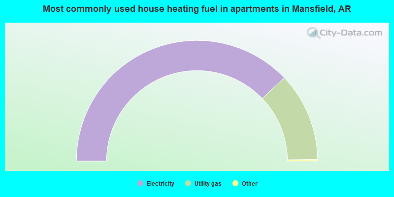
- 76.0%Electricity
- 24.0%Utility gas
Mansfield compared to Arkansas state average:
- Median house value below state average.
- Unemployed percentage significantly below state average.
- Black race population percentage significantly below state average.
- Hispanic race population percentage significantly below state average.
- Foreign-born population percentage below state average.
- Length of stay since moving in significantly above state average.
- House age above state average.
- Number of college students below state average.
- Percentage of population with a bachelor's degree or higher significantly below state average.