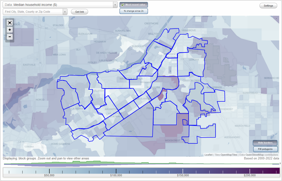
Riverside, California Neighborhood Map - Income, House Prices, Occupations, Boundaries
Settings
X

- City boundary
- Neighborhood boundaries
Business Search - 14 Million verified businesses
Neighborhoods:
Airport, Allesandro Heights, Arlanza, Arlington, Arlington Heights, Arlington South, Canyon Crest, Casa Blanca, Downtown, Eastside, Grand, Hawarden Hills, Hunter Industrial Park, La Sierra, La Sierra Acres, La Sierra Hills, La Sierra South, Magnolia Center, Mission Grove, Northside, Orangecrest, Presidential Park, Ramona, Sycamore Canyon, University, Victoria, Wood StreetsAirport neighborhood in Riverside statistics: (Find on map)
Area: 3.241 square miles
Population: 12,827
Population density:
Median household income in 2021:
Median rent in in 2021:
Male vs Females
Median age
Average estimated value of detached houses in 2021 (81.4% of all units):
Most popular occupations of males: construction, extraction, and maintenance occupations (22.9%); service occupations (15.9%); production occupations (14.7%); sales and office occupations (14.4%); material moving occupations (8.8%); management occupations (except farmers) (6.3%); transportation occupations (4.5%)
Most popular occupations of females: sales and office occupations (32.1%); service occupations (22.7%); material moving occupations (13.1%); education, training, and library occupations (8.5%); management occupations (except farmers) (5.8%); production occupations (5.1%); business and financial operations occupations (2.8%)
Roads and streets: Central Ave; Jurupa Ave; Van Buren Blvd; Hillside Ave; Fremont St; Doolittle Ave; Essex St; Acorn St; Mountain View Ave; Gemende Dr; Wilderness Ave; Columbus St; Walter St; Phoenix Ave; Clifton Blvd; Industrial Ave (Industrial St); Dean Way; Norman Way; Wayman St; Rexford Dr; Willard Way; Sierra St; Jasmine St; Vanessa St; Streeter Ave; Dewey Ave; Rochester St (Rochester Pl); Payton St (Payton Ave); Ordway St; Granada Ave; el Cajon Dr; la Jolla Dr; Republic St; Sunnyside Dr; Holly Ridge Dr; Scott Ave; Morris St; Antioch Ave; Flight Rd; Glenhurst St; Ensenada Way; Chester St; Longhill St; Kitty Hawk Dr; Sheppard St; Urban St; Ed Perkic St; Vera St; Crystal Hill St; Beatty Dr; Benecia Dr; Shannon Rd; Arlington Ave; Orangewood Dr; Burlingame Dr; Wisteria Dr; Clifford St; Jerome St; Havilland Ln; Portola Way; Soledad Dr; Florence St; Maybelle St; William St; Vickers Dr (Vickers Rd); Green Valley Rd (Green Valley St); el Molino Ave; Carissa Ave; Anita Pl; Rickenbacker Ave; Griffith St; Morningside Ave; Rhonda Rd; Winterhaven Ave; Vonnie Ct; Agnes Pl; Denney Pl; View Park Ct; Holbrook Way; Canoga Pl; Airport Dr; Petite Ct; Simon Ct; Balboa Way; Eva Pl; Cathy Pl; Evelyn Pl; el Camino Pl; del Rosa Pl; Fuller Ct; Gage St; del Monte St; Wren Ct.
Railroad features: Union Pacific RR.
Airport neighborhood detailed profile
Area: 3.241 square miles
Population: 12,827
Population density:
| Airport: | 3,958 people per square mile |
| Riverside: | 4,062 people per square mile |
Median household income in 2021:
| Airport: | $65,676 |
| Riverside: | $76,558 |
Median rent in in 2021:
| Airport: | $1,428 |
| Riverside: | $1,441 |
Male vs Females
| Males: | 6,904 |
| Females: | 5,923 |
Median age
| Males: | 35.2 years |
| Females: | 39.0 years |
Average estimated value of detached houses in 2021 (81.4% of all units):
| Airport: | $333,077 |
| Riverside: | $445,816 |
Most popular occupations of males: construction, extraction, and maintenance occupations (22.9%); service occupations (15.9%); production occupations (14.7%); sales and office occupations (14.4%); material moving occupations (8.8%); management occupations (except farmers) (6.3%); transportation occupations (4.5%)
Most popular occupations of females: sales and office occupations (32.1%); service occupations (22.7%); material moving occupations (13.1%); education, training, and library occupations (8.5%); management occupations (except farmers) (5.8%); production occupations (5.1%); business and financial operations occupations (2.8%)
Roads and streets: Central Ave; Jurupa Ave; Van Buren Blvd; Hillside Ave; Fremont St; Doolittle Ave; Essex St; Acorn St; Mountain View Ave; Gemende Dr; Wilderness Ave; Columbus St; Walter St; Phoenix Ave; Clifton Blvd; Industrial Ave (Industrial St); Dean Way; Norman Way; Wayman St; Rexford Dr; Willard Way; Sierra St; Jasmine St; Vanessa St; Streeter Ave; Dewey Ave; Rochester St (Rochester Pl); Payton St (Payton Ave); Ordway St; Granada Ave; el Cajon Dr; la Jolla Dr; Republic St; Sunnyside Dr; Holly Ridge Dr; Scott Ave; Morris St; Antioch Ave; Flight Rd; Glenhurst St; Ensenada Way; Chester St; Longhill St; Kitty Hawk Dr; Sheppard St; Urban St; Ed Perkic St; Vera St; Crystal Hill St; Beatty Dr; Benecia Dr; Shannon Rd; Arlington Ave; Orangewood Dr; Burlingame Dr; Wisteria Dr; Clifford St; Jerome St; Havilland Ln; Portola Way; Soledad Dr; Florence St; Maybelle St; William St; Vickers Dr (Vickers Rd); Green Valley Rd (Green Valley St); el Molino Ave; Carissa Ave; Anita Pl; Rickenbacker Ave; Griffith St; Morningside Ave; Rhonda Rd; Winterhaven Ave; Vonnie Ct; Agnes Pl; Denney Pl; View Park Ct; Holbrook Way; Canoga Pl; Airport Dr; Petite Ct; Simon Ct; Balboa Way; Eva Pl; Cathy Pl; Evelyn Pl; el Camino Pl; del Rosa Pl; Fuller Ct; Gage St; del Monte St; Wren Ct.
Railroad features: Union Pacific RR.
Airport neighborhood detailed profile
Allesandro Heights neighborhood in Riverside statistics: (Find on map)
Area: 3.412 square miles
Population: 2,181
Population density:
Median household income in 2021:
Median rent in in 2021:
Male vs Females
Median age
Average estimated value of detached houses in 2021 (93.6% of all units):
Most popular occupations of males: construction, extraction, and maintenance occupations (14.4%); management occupations (except farmers) (13.7%); sales and office occupations (11.1%); service occupations (8.4%); transportation occupations (8.2%); education, training, and library occupations (5.5%); production occupations (4.6%)
Most popular occupations of females: sales and office occupations (33.6%); service occupations (18.7%); education, training, and library occupations (13.4%); healthcare practitioners and technical occupations (9.2%); management occupations (except farmers) (4.9%); transportation occupations (4.2%); business and financial operations occupations (3.6%)
Roads and streets: Bradley St; Overlook Pkwy; Highridge St; Golden Star Ave; Whitegate Ave; Tiger Tail Dr; Horizon View Dr; Choi Dr; Muirfield Rd; Chateau Ridge Ln; Wyndham Hill Dr; Talcey Ter; Polo Ct; Royal Hunt Ridge Dr; Rimroad; Matterhorn St (Matterhorn Dr); Eagle Crest Ct; Highridge Ct; Ruth Way; Ravenwood Ln; Northhampton Dr; Gopher Gulch Rd; Chartwell Dr; Basel Pl; White Haven Ln; Milligan Dr; Kingdom Dr; Canyon Hill Dr; Bodewin Ct; Woodland Dr; Hastings Ln; Gilcross Way; Bernette Way; Orozco Dr; Ridgeline Dr; Laurie Dr; Westpark Dr; Woodshole Ct; Kingsport Dr; Ramsgate Ct; Weston Way; Dustin Pl; Pinnacle Ridge Rd; Pitcairn St; Woodvale Ln; Kimberly Jean Ct; Jola Dr; Westbrook Dr; Boice Ln; Crevasse Ct; Jessamyn Ct; Royal Huntrige Dr; Ranch View Rd (Firestone Hill Dr); Garth St; Brandon Ct; Washington St; Pine Crest Dr; Westgate Ct; Bishop Pl; Ginsberg Ct; Plateau Ct; Silver Hills Dr; Houser Pl; Dunkirk Ln; Chateau View Dr; Chabot Ct; Old Oak Ct; Treeview Ln; Coco Ct; Boulder Creek Ln; Eastgate Ct; Peak Ct; Kohler Ct; Berne Ct; Corinthian Way.
Allesandro Heights neighborhood detailed profile
Area: 3.412 square miles
Population: 2,181
Population density:
| Allesandro Heights: | 639 people per square mile |
| Riverside: | 4,062 people per square mile |
Median household income in 2021:
| Allesandro Heights: | $141,572 |
| Riverside: | $76,558 |
Median rent in in 2021:
| Allesandro Heights: | $1,263 |
| Riverside: | $1,441 |
Male vs Females
| Males: | 1,161 |
| Females: | 1,019 |
Median age
| Males: | 44.5 years |
| Females: | 50.2 years |
Average estimated value of detached houses in 2021 (93.6% of all units):
| Allesandro Heights: | $729,888 |
| Riverside: | $445,816 |
Most popular occupations of males: construction, extraction, and maintenance occupations (14.4%); management occupations (except farmers) (13.7%); sales and office occupations (11.1%); service occupations (8.4%); transportation occupations (8.2%); education, training, and library occupations (5.5%); production occupations (4.6%)
Most popular occupations of females: sales and office occupations (33.6%); service occupations (18.7%); education, training, and library occupations (13.4%); healthcare practitioners and technical occupations (9.2%); management occupations (except farmers) (4.9%); transportation occupations (4.2%); business and financial operations occupations (3.6%)
Roads and streets: Bradley St; Overlook Pkwy; Highridge St; Golden Star Ave; Whitegate Ave; Tiger Tail Dr; Horizon View Dr; Choi Dr; Muirfield Rd; Chateau Ridge Ln; Wyndham Hill Dr; Talcey Ter; Polo Ct; Royal Hunt Ridge Dr; Rimroad; Matterhorn St (Matterhorn Dr); Eagle Crest Ct; Highridge Ct; Ruth Way; Ravenwood Ln; Northhampton Dr; Gopher Gulch Rd; Chartwell Dr; Basel Pl; White Haven Ln; Milligan Dr; Kingdom Dr; Canyon Hill Dr; Bodewin Ct; Woodland Dr; Hastings Ln; Gilcross Way; Bernette Way; Orozco Dr; Ridgeline Dr; Laurie Dr; Westpark Dr; Woodshole Ct; Kingsport Dr; Ramsgate Ct; Weston Way; Dustin Pl; Pinnacle Ridge Rd; Pitcairn St; Woodvale Ln; Kimberly Jean Ct; Jola Dr; Westbrook Dr; Boice Ln; Crevasse Ct; Jessamyn Ct; Royal Huntrige Dr; Ranch View Rd (Firestone Hill Dr); Garth St; Brandon Ct; Washington St; Pine Crest Dr; Westgate Ct; Bishop Pl; Ginsberg Ct; Plateau Ct; Silver Hills Dr; Houser Pl; Dunkirk Ln; Chateau View Dr; Chabot Ct; Old Oak Ct; Treeview Ln; Coco Ct; Boulder Creek Ln; Eastgate Ct; Peak Ct; Kohler Ct; Berne Ct; Corinthian Way.
Allesandro Heights neighborhood detailed profile
Arlanza neighborhood in Riverside statistics: (Find on map)
Area: 2.879 square miles
Population: 19,207
Population density:
Median household income in 2021:
Median rent in in 2021:
Male vs Females
Median age
Average estimated value of detached houses in 2021 (80.3% of all units):
Most popular occupations of males: service occupations (17.7%); construction, extraction, and maintenance occupations (17.5%); sales and office occupations (15.4%); material moving occupations (10.4%); production occupations (8.4%); transportation occupations (7.3%); management occupations (except farmers) (5.5%)
Most popular occupations of females: sales and office occupations (35.7%); service occupations (25.2%); material moving occupations (8.4%); production occupations (7.8%); education, training, and library occupations (4.9%); community and social services occupations (3.4%); management occupations (except farmers) (3.2%)
Roads and streets: Rutland Ave; Crest Ave; Challen Ave; Wells Ave; Cypress Ave; Noble St; Philbin Ave; Jurupa Ave; Grammercy Pl; Montgomery St; Arlington Ave; Tomlinson Ave; Randolph St; Warren St; Trey Ave; Campbell Ave; Bruce Ave; Corwin Ln; Penny Dr; Babb Ave; Dorinda Dr; Picker St; Wholstetter St; Greenpoint Ave; Ivanhoe Ave; Jo Jo Way; Cook Ave; Boardwalk Dr; Lake St; Harold St; Coonen Dr; Bolton Ave; Via Norte Dr; Foothill Ave; Sylvan Ave (Sylvan Dr); Idyllwild Ln; Kent Ave; Altadena Dr; Hedrick Ave; Ellen St; Glendale Ave; Remington Dr; Adair Ave; Janet Ave; Mandalay Ct; Farrier Ave; Red Bluff Rd; Bradford St; Ontario St; Chapel St; Beejay St; Singleton Way; Green Ave; Ben Lomand Way; Mia Ave; Nancy Way; Palos Dr; Camelot Rd; Olympia Dr; Eddystone St; Flagstone Ave; Copperlantern Dr; Keller Ave; Alabama St; Lewis Ave; Tanforan Dr; Lessie Ln; Biscayne Ave; Comstock Ave; Cabrillo Dr; Begonia Cir; Julian Dr; Geranium Pl; Orlando Dr; Hobart Dr; Hillsborough Ln; Zinnia Pl; Redrock Ave; Leucadia Ln; Firebird Ln; Auld St; Adler Pl; Bartel Dr; Hershey Way; Daytona Ave; Modesto Dr; Phillip Ave; Reynard Ave; Rossini Ct; Daniel Dr; Temecula Ct; Galway Ct; Medallion Pl; Silverado Pl; Citadel Ct; Rockhurst Ct; Eagle Way; Mendocino Dr; Manitoba Pl; Carlson Pl; Chula Vista Way; Larry Way; Dunn Ct; Alta Loma Way; Parker Way; Keating Dr; Macy Ct; Adobe Ave; Halsey Pl; Key West Dr; Curran Dr; Pasadena Pl; Batavia Way; Jamaica Cir; Bellamy Pl; Encanto Way; Nichols Ct; Vanguard Way; Carnation Ct; Drayton Pl; Pobre Pl; Austin Ct; Duval Pl; Remington Rd; Calmhill Dr; Presidio Cir; San Joaquin Way; Keegan Ct; Cobb St; Burnham Ct; Della St; Cudahy Ct; Solvang Pl; Amity Ct; Logan Ct; Saturn Cir; Mallard Rd.
Other features: Canal.
Arlanza neighborhood detailed profile
Area: 2.879 square miles
Population: 19,207
Population density:
| Arlanza: | 6,670 people per square mile |
| Riverside: | 4,062 people per square mile |
Median household income in 2021:
| Arlanza: | $72,318 |
| Riverside: | $76,558 |
Median rent in in 2021:
| Arlanza: | $1,516 |
| Riverside: | $1,441 |
Male vs Females
| Males: | 9,637 |
| Females: | 9,569 |
Median age
| Males: | 32.0 years |
| Females: | 33.6 years |
Average estimated value of detached houses in 2021 (80.3% of all units):
| Arlanza: | $351,723 |
| Riverside: | $445,816 |
Most popular occupations of males: service occupations (17.7%); construction, extraction, and maintenance occupations (17.5%); sales and office occupations (15.4%); material moving occupations (10.4%); production occupations (8.4%); transportation occupations (7.3%); management occupations (except farmers) (5.5%)
Most popular occupations of females: sales and office occupations (35.7%); service occupations (25.2%); material moving occupations (8.4%); production occupations (7.8%); education, training, and library occupations (4.9%); community and social services occupations (3.4%); management occupations (except farmers) (3.2%)
Roads and streets: Rutland Ave; Crest Ave; Challen Ave; Wells Ave; Cypress Ave; Noble St; Philbin Ave; Jurupa Ave; Grammercy Pl; Montgomery St; Arlington Ave; Tomlinson Ave; Randolph St; Warren St; Trey Ave; Campbell Ave; Bruce Ave; Corwin Ln; Penny Dr; Babb Ave; Dorinda Dr; Picker St; Wholstetter St; Greenpoint Ave; Ivanhoe Ave; Jo Jo Way; Cook Ave; Boardwalk Dr; Lake St; Harold St; Coonen Dr; Bolton Ave; Via Norte Dr; Foothill Ave; Sylvan Ave (Sylvan Dr); Idyllwild Ln; Kent Ave; Altadena Dr; Hedrick Ave; Ellen St; Glendale Ave; Remington Dr; Adair Ave; Janet Ave; Mandalay Ct; Farrier Ave; Red Bluff Rd; Bradford St; Ontario St; Chapel St; Beejay St; Singleton Way; Green Ave; Ben Lomand Way; Mia Ave; Nancy Way; Palos Dr; Camelot Rd; Olympia Dr; Eddystone St; Flagstone Ave; Copperlantern Dr; Keller Ave; Alabama St; Lewis Ave; Tanforan Dr; Lessie Ln; Biscayne Ave; Comstock Ave; Cabrillo Dr; Begonia Cir; Julian Dr; Geranium Pl; Orlando Dr; Hobart Dr; Hillsborough Ln; Zinnia Pl; Redrock Ave; Leucadia Ln; Firebird Ln; Auld St; Adler Pl; Bartel Dr; Hershey Way; Daytona Ave; Modesto Dr; Phillip Ave; Reynard Ave; Rossini Ct; Daniel Dr; Temecula Ct; Galway Ct; Medallion Pl; Silverado Pl; Citadel Ct; Rockhurst Ct; Eagle Way; Mendocino Dr; Manitoba Pl; Carlson Pl; Chula Vista Way; Larry Way; Dunn Ct; Alta Loma Way; Parker Way; Keating Dr; Macy Ct; Adobe Ave; Halsey Pl; Key West Dr; Curran Dr; Pasadena Pl; Batavia Way; Jamaica Cir; Bellamy Pl; Encanto Way; Nichols Ct; Vanguard Way; Carnation Ct; Drayton Pl; Pobre Pl; Austin Ct; Duval Pl; Remington Rd; Calmhill Dr; Presidio Cir; San Joaquin Way; Keegan Ct; Cobb St; Burnham Ct; Della St; Cudahy Ct; Solvang Pl; Amity Ct; Logan Ct; Saturn Cir; Mallard Rd.
Other features: Canal.
Arlanza neighborhood detailed profile
Arlington neighborhood in Riverside statistics: (Find on map)
Area: 1.687 square miles
Population: 4,877
Population density:
Median household income in 2021:
Median rent in in 2021:
Male vs Females
Median age
Average estimated value of detached houses in 2021 (45.8% of all units):
Most popular occupations of males: service occupations (22.0%); management occupations (except farmers) (19.2%); sales and office occupations (12.4%); construction, extraction, and maintenance occupations (12.2%); healthcare practitioners and technical occupations (8.5%); production occupations (6.4%); material moving occupations (4.8%)
Most popular occupations of females: service occupations (30.9%); sales and office occupations (25.6%); community and social services occupations (9.1%); production occupations (8.5%); material moving occupations (8.3%); healthcare practitioners and technical occupations (6.1%); management occupations (except farmers) (4.5%)
Limited-access highways (interstate or state) in this neighborhood: State Hwy 91 (Riverside Fwy).
Roads and streets: Van Buren Blvd; Magnolia Ave; Harrison St; Donald Ave; Garfield St; McKenzie St (Mc Kenzie St); California Ave; Primrose Dr; Everest Ave; Myers St; Kingsbury Pl; Andrew St; Farnham Pl; Stotts St; Hole Ave; Hayes St; Ross St; Roosevelt St; Taft St; Diana Ave; Bolton Ave; Sharon Ave; Tomlinson Ave (California Ave); Duncan Ave; Wilbur St; Sage Ave; Delano Dr; Lafayette St; Castleman St; County Farm Rd; Jersey Dr; Miller St; Muir St; Purdy St; Acacia St; Macarthur Rd; Artesian St; Sequoia St; Hawthorne Ave; County Circle Dr; Mariposa Ave; Dawes St; Belmont Dr; Mason St; Selma Ave; Megginson Ln; Estrellita St; Bonita Ave; Nellie St; Turnbull Rd; Dykes Ln; Azalea St; Shirley St; Martha Way; Jackson St; Cirrus Way; Sidney St; Shelley Way; Winship Pl; Reynolds Rd; Thompson Way; Lionhead Ave; Barclay St; Pershing Dr; Omar St; Jeremiah Ct; Aldrich Ct; Sunfair Ln; Inez Ct; Terry Ln; Manx Ct; Arnett Ct; Judy Ct; Mildred Ct; Sara Ct; Saffron Ct; Carver Ct; Giles Ct; Monitor Ct; Merrimac Ct; Ilex Ct.
Arlington neighborhood detailed profile
Area: 1.687 square miles
Population: 4,877
Population density:
| Arlington: | 2,891 people per square mile |
| Riverside: | 4,062 people per square mile |
Median household income in 2021:
| Arlington: | $60,526 |
| Riverside: | $76,558 |
Median rent in in 2021:
| Arlington: | $1,254 |
| Riverside: | $1,441 |
Male vs Females
| Males: | 1,988 |
| Females: | 2,889 |
Median age
| Males: | 32.7 years |
| Females: | 40.9 years |
Average estimated value of detached houses in 2021 (45.8% of all units):
| Arlington: | $365,874 |
| Riverside: | $445,816 |
Most popular occupations of males: service occupations (22.0%); management occupations (except farmers) (19.2%); sales and office occupations (12.4%); construction, extraction, and maintenance occupations (12.2%); healthcare practitioners and technical occupations (8.5%); production occupations (6.4%); material moving occupations (4.8%)
Most popular occupations of females: service occupations (30.9%); sales and office occupations (25.6%); community and social services occupations (9.1%); production occupations (8.5%); material moving occupations (8.3%); healthcare practitioners and technical occupations (6.1%); management occupations (except farmers) (4.5%)
Limited-access highways (interstate or state) in this neighborhood: State Hwy 91 (Riverside Fwy).
Roads and streets: Van Buren Blvd; Magnolia Ave; Harrison St; Donald Ave; Garfield St; McKenzie St (Mc Kenzie St); California Ave; Primrose Dr; Everest Ave; Myers St; Kingsbury Pl; Andrew St; Farnham Pl; Stotts St; Hole Ave; Hayes St; Ross St; Roosevelt St; Taft St; Diana Ave; Bolton Ave; Sharon Ave; Tomlinson Ave (California Ave); Duncan Ave; Wilbur St; Sage Ave; Delano Dr; Lafayette St; Castleman St; County Farm Rd; Jersey Dr; Miller St; Muir St; Purdy St; Acacia St; Macarthur Rd; Artesian St; Sequoia St; Hawthorne Ave; County Circle Dr; Mariposa Ave; Dawes St; Belmont Dr; Mason St; Selma Ave; Megginson Ln; Estrellita St; Bonita Ave; Nellie St; Turnbull Rd; Dykes Ln; Azalea St; Shirley St; Martha Way; Jackson St; Cirrus Way; Sidney St; Shelley Way; Winship Pl; Reynolds Rd; Thompson Way; Lionhead Ave; Barclay St; Pershing Dr; Omar St; Jeremiah Ct; Aldrich Ct; Sunfair Ln; Inez Ct; Terry Ln; Manx Ct; Arnett Ct; Judy Ct; Mildred Ct; Sara Ct; Saffron Ct; Carver Ct; Giles Ct; Monitor Ct; Merrimac Ct; Ilex Ct.
Arlington neighborhood detailed profile
Arlington Heights neighborhood in Riverside statistics: (Find on map)
Area: 6.946 square miles
Population: 2,307
Population density:
Median household income in 2021:
Median rent in in 2021:
Male vs Females
Median age
Housing prices:
Average estimated value of detached houses in 2021 (98.2% of all units):
Average estimated value of townhouses or other attached units in 2021 (132.5% of all units):
Most popular occupations of males: material moving occupations (21.1%); sales and office occupations (19.8%); service occupations (14.4%); management occupations (except farmers) (9.0%); production occupations (5.5%); education, training, and library occupations (5.4%); construction, extraction, and maintenance occupations (5.3%)
Most popular occupations of females: sales and office occupations (38.9%); architecture and engineering occupations (15.7%); service occupations (14.9%); education, training, and library occupations (8.2%); healthcare practitioners and technical occupations (5.0%); legal occupations (4.7%); management occupations (except farmers) (4.2%)
Roads and streets: Cleveland Ave; Dufferin Ave; Irving St; Van Buren Blvd; Jackson St; Monroe St; Jefferson St; Gratton St; Hermosa Dr; Adams St; Heather Ln; Grace St; Harrison St; Saint Lawrence St; Victoria Ave; Myers St; Summit St; John St; Madison St; McAllister St; Equestrian Dr; Huntington St; Lenox Ave; Gladstone Blvd; Bradley St; Pontoosuc Ave; Firethorn Ave; Short St; Stewart St; Gibson St; Prenda Ave; Graylock Ave; Frontier Ave; Canada Way; Broadacre Pl; Croyance Dr; Martinez Ln; Quadrille Ct; Onota Ave; Coteau Dr; Klamath Ct; Kitchener St.
Other features: Gage Cnl.
Arlington Heights neighborhood detailed profile
Area: 6.946 square miles
Population: 2,307
Population density:
| Arlington Heights: | 332 people per square mile |
| Riverside: | 4,062 people per square mile |
Median household income in 2021:
| Arlington Heights: | $87,076 |
| Riverside: | $76,558 |
Median rent in in 2021:
| Arlington Heights: | $1,462 |
| Riverside: | $1,441 |
Male vs Females
| Males: | 1,265 |
| Females: | 1,041 |
Median age
| Males: | 41.7 years |
| Females: | 47.2 years |
Housing prices:
Average estimated value of detached houses in 2021 (98.2% of all units):
| Arlington Heights: | $691,549 |
| Riverside: | $445,816 |
Average estimated value of townhouses or other attached units in 2021 (132.5% of all units):
| This neighborhood: | $354,663 |
| city: | $255,818 |
Most popular occupations of males: material moving occupations (21.1%); sales and office occupations (19.8%); service occupations (14.4%); management occupations (except farmers) (9.0%); production occupations (5.5%); education, training, and library occupations (5.4%); construction, extraction, and maintenance occupations (5.3%)
Most popular occupations of females: sales and office occupations (38.9%); architecture and engineering occupations (15.7%); service occupations (14.9%); education, training, and library occupations (8.2%); healthcare practitioners and technical occupations (5.0%); legal occupations (4.7%); management occupations (except farmers) (4.2%)
Roads and streets: Cleveland Ave; Dufferin Ave; Irving St; Van Buren Blvd; Jackson St; Monroe St; Jefferson St; Gratton St; Hermosa Dr; Adams St; Heather Ln; Grace St; Harrison St; Saint Lawrence St; Victoria Ave; Myers St; Summit St; John St; Madison St; McAllister St; Equestrian Dr; Huntington St; Lenox Ave; Gladstone Blvd; Bradley St; Pontoosuc Ave; Firethorn Ave; Short St; Stewart St; Gibson St; Prenda Ave; Graylock Ave; Frontier Ave; Canada Way; Broadacre Pl; Croyance Dr; Martinez Ln; Quadrille Ct; Onota Ave; Coteau Dr; Klamath Ct; Kitchener St.
Other features: Gage Cnl.
Arlington Heights neighborhood detailed profile
Arlington South neighborhood in Riverside statistics: (Find on map)
Area: 1.364 square miles
Population: 4,993
Population density:
Median household income in 2021:
Median rent in in 2021:
Male vs Females
Median age
Average estimated value of detached houses in 2021 (81.4% of all units):
Most popular occupations of males: service occupations (11.7%); sales and office occupations (10.8%); material moving occupations (10.5%); construction, extraction, and maintenance occupations (10.3%); management occupations (except farmers) (8.7%); transportation occupations (6.1%); business and financial operations occupations (5.5%)
Most popular occupations of females: sales and office occupations (29.3%); service occupations (17.2%); production occupations (10.3%); management occupations (except farmers) (9.1%); education, training, and library occupations (7.3%); community and social services occupations (7.1%); healthcare practitioners and technical occupations (6.7%)
Limited-access highways (interstate or state) in this neighborhood: Riverside Fwy (State Hwy 91).
Roads and streets: Indiana Ave; Lincoln Ave; Van Buren Blvd; Harrison St; Victoria Ave; Myers St; Gibson St; McAllister St; Glenbrook St; Fox St; Sh-91; Shadyview St; Las Flores Ave; Butterfield Rd; Saratoga St; Rhinelander Dr; Diana Ave; Rudicill St; Joshua Tree Rd; Cll la Cuesta; Walnut Grove Ave; Cll Esplanade; Antares Dr; Loyola St; Wichita Dr; Winnifred St; Woodhaven St; Mohawk Trl; Mesquite Dr; Bella Vista Ave; Seneca Pass; Balmoral Ct; Dunbar Dr; la Loma Pl; Abraham Ave; Litchfield Dr; Aegean Dr; Willowgrove Pl; Aralia Dr; Vineyard Way; Westchester Dr; Saguaro Rd; Stockton Ct; Chickasaw Pass; Shade Tree Ln; Narnia Dr; Cll Angostura; Douglas Dr; Bordeaux Dr; Cll Sausalito; Tyler St; Nopal Pl; Hoya Pl; Zuni Pass; Delphi Ct; Linda Lou Ln; Danube Way; Cll Tierra Santa; Constellation Pl; Acaciawood Pl; Tomahawk Cir; Charter Oak Ln; Hermitage Ln; Call Dr; Aguilar St; Floravista Ct; Mc Nicholl Dr; Cll Tampico; Maywood Way; Agave Pl; Coral Tree Ln; Felix Ct; Flax Pl; Fuchsia Pl; Tamarisk Pl; Cll del Casa; Marisa Ct; Landmark Ct; Cll Loma Roja; Cll Loma Verde; Jonquil Pl; Conaty Pl; Marigold Pl; Copley Ln; Drake Pl; Sturbridge Ct; Nemaha Ct (Nemaha Cir); Blackhawk Cir; Deodar Ct; Bamboo Ln; Crestwood Pl; Donald Ave; Wilbur St; Sidney St; Autumn Glen Dr; Sioux Cir; Piper Pl.
Railroad features: at and Sf Rlwy.
Other features: Riverside Cnl.
Arlington South neighborhood detailed profile
Area: 1.364 square miles
Population: 4,993
Population density:
| Arlington South: | 3,660 people per square mile |
| Riverside: | 4,062 people per square mile |
Median household income in 2021:
| Arlington South: | $84,903 |
| Riverside: | $76,558 |
Median rent in in 2021:
| Arlington South: | $1,635 |
| Riverside: | $1,441 |
Male vs Females
| Males: | 2,477 |
| Females: | 2,516 |
Median age
| Males: | 35.8 years |
| Females: | 41.9 years |
Average estimated value of detached houses in 2021 (81.4% of all units):
| Arlington South: | $416,983 |
| Riverside: | $445,816 |
Most popular occupations of males: service occupations (11.7%); sales and office occupations (10.8%); material moving occupations (10.5%); construction, extraction, and maintenance occupations (10.3%); management occupations (except farmers) (8.7%); transportation occupations (6.1%); business and financial operations occupations (5.5%)
Most popular occupations of females: sales and office occupations (29.3%); service occupations (17.2%); production occupations (10.3%); management occupations (except farmers) (9.1%); education, training, and library occupations (7.3%); community and social services occupations (7.1%); healthcare practitioners and technical occupations (6.7%)
Limited-access highways (interstate or state) in this neighborhood: Riverside Fwy (State Hwy 91).
Roads and streets: Indiana Ave; Lincoln Ave; Van Buren Blvd; Harrison St; Victoria Ave; Myers St; Gibson St; McAllister St; Glenbrook St; Fox St; Sh-91; Shadyview St; Las Flores Ave; Butterfield Rd; Saratoga St; Rhinelander Dr; Diana Ave; Rudicill St; Joshua Tree Rd; Cll la Cuesta; Walnut Grove Ave; Cll Esplanade; Antares Dr; Loyola St; Wichita Dr; Winnifred St; Woodhaven St; Mohawk Trl; Mesquite Dr; Bella Vista Ave; Seneca Pass; Balmoral Ct; Dunbar Dr; la Loma Pl; Abraham Ave; Litchfield Dr; Aegean Dr; Willowgrove Pl; Aralia Dr; Vineyard Way; Westchester Dr; Saguaro Rd; Stockton Ct; Chickasaw Pass; Shade Tree Ln; Narnia Dr; Cll Angostura; Douglas Dr; Bordeaux Dr; Cll Sausalito; Tyler St; Nopal Pl; Hoya Pl; Zuni Pass; Delphi Ct; Linda Lou Ln; Danube Way; Cll Tierra Santa; Constellation Pl; Acaciawood Pl; Tomahawk Cir; Charter Oak Ln; Hermitage Ln; Call Dr; Aguilar St; Floravista Ct; Mc Nicholl Dr; Cll Tampico; Maywood Way; Agave Pl; Coral Tree Ln; Felix Ct; Flax Pl; Fuchsia Pl; Tamarisk Pl; Cll del Casa; Marisa Ct; Landmark Ct; Cll Loma Roja; Cll Loma Verde; Jonquil Pl; Conaty Pl; Marigold Pl; Copley Ln; Drake Pl; Sturbridge Ct; Nemaha Ct (Nemaha Cir); Blackhawk Cir; Deodar Ct; Bamboo Ln; Crestwood Pl; Donald Ave; Wilbur St; Sidney St; Autumn Glen Dr; Sioux Cir; Piper Pl.
Railroad features: at and Sf Rlwy.
Other features: Riverside Cnl.
Arlington South neighborhood detailed profile
Canyon Crest neighborhood in Riverside statistics: (Find on map)
Area: 5.159 square miles
Population: 16,920
Population density:
Median household income in 2021:
Median rent in in 2021:
Male vs Females
Median age
Housing prices:
Average estimated value of detached houses in 2021 (69.6% of all units):
Average estimated value of townhouses or other attached units in 2021 (8.8% of all units):
Most popular occupations of males: sales and office occupations (20.2%); management occupations (except farmers) (17.8%); education, training, and library occupations (8.1%); healthcare practitioners and technical occupations (7.2%); construction, extraction, and maintenance occupations (7.2%); service occupations (7.1%); business and financial operations occupations (6.3%)
Most popular occupations of females: education, training, and library occupations (17.8%); sales and office occupations (16.9%); service occupations (16.0%); healthcare practitioners and technical occupations (13.1%); management occupations (except farmers) (8.8%); business and financial operations occupations (7.4%); community and social services occupations (4.5%)
Limited-access highways (interstate or state) in this neighborhood: State Hwy 60 (I- 215, Moreno Valley Fwy).
Roads and streets: Central Ave; Canyon Crest Dr; Lochmoor Dr; Century Ave; Ransom Rd; Via Vista Dr; Country Club Dr; Via Zapata; Fair Isle Dr; Alessandro Blvd; el Cerrito Dr; Berry Rd; Trafalgar Ave; Shaker Dr; Coronet Dr; Sycamore Canyon Blvd (Box Springs Blvd); Monte Vista Dr; Claridge Dr; Rycroft Dr; Via Vallarta; Golden Vale Dr; Box Spring Blvd (Box Springs Blvd); Applecross Dr; Via la Paloma; Quail Run Rd; Via Pintada; Intervale Dr; Windemere Way; Inner Circle Dr; Westview Dr; Academy Ave; Wimbledon Way (Wimbledon Dr); Omega St; Haddington Dr; Wilding Pl; Century Hill Dr; Via Pito (Via Loma); Melville Dr; Voltaire Dr; Old Bridge Rd; Allendale Dr; Promontory Ln; Chapala Dr; Lyndhurst Dr; Versailles Cir; Barranca Dr; Speyside Rd; Natalie Ln; el Capitan Dr; Apostle Ln; Shakespeare Dr; I-215; Via San Jacinto; Courtland Dr; Abernathy Dr; Trenton Dr; Via Conception; Crestbrook Dr; Fetlock Way; Pearblossom Dr; Sandtrack Rd; Flemington Rd; Le Conte Dr; Bellefontaine Dr; Cedarhill Pl; Cherry Hill Dr; Sunbeam Dr; Bruin Dr; Navajo Dr; Via Susana; Garden Hills Way; Middle Creek Rd; Bluffwood Dr; Hacienda Dr; Ranchgrove Rd; Dahlia Ln; Via Sotelo; S University Dr (University Dr S); Sunset Ranch Dr; Blazewood St; Jaguar Dr; Tolkien Rd; Apache Trl; Glen Aire Ave; Timberlane Dr; Lockerton Ln; Canyon Hill Dr; Sycamore Canyon; Kendrick Dr; Sutherland Dr; Matheson Dr; Via Tioga; McIntosh Dr (Mc Intosh Dr, Macintosh Dr); Via Mindi; Colina Way; Big Horn Dr; Perthshire Pl; Via Maria Buena; Cresthaven Dr; Parkside Dr; Roanoak Pl; Fairhill Dr; Santorini Rd; Grossmont Dr; Windhill Dr; Via del Tecolote; Rosehill Dr; Alder Canyon; Livingston St; Cannich Rd; Halifax Dr; Via Junipero Serra; Cadwell Ct; Grovehill Dr; Via Mensabe; Wainwright Ct; Gaskin Pl; Whitestone Dr (Whitestone Pl); Withers Rd; Oswego Dr; Tareyton Dr; Bond St; Tonia Ct; Atwater Ave; Port-Au-Prince Cir; Keswick Ave; Canyon Estates Ct; Ravencrest Ct; Lynridge Ct; Hackamore Pl; Saint Augustine Dr; Daffodil Dr; Trojan Ct; Randwick Rd; Hawkley Dr; Via Coiba; Stockport Dr; Sycamore Hill Dr; Canyon Ridge; Athens St; Nicola Dr; Lamart Dr; Canyon Bluff; Boulder Bluffs; Buckskin Pl; Black Oak Pl; Bannock Dr; Overlook Pkwy; Tiffany Dr; Via Mesa Verde; Corinthian Way; Via Cartago; Cottonwood Canyon; Mykonos Ln; San Cristobal Dr; Humboldt Ct; Via Cervantes; Via Pueblo; Stonehaven Ct; Thornhill Dr; Caulfield Ct; Canyon Creek Loop; Ranchwood Pl; Danbrook Dr; Stoneykirk Dr; Ransom Pl; Shelburn Ln; Tolstoy Way; Crete Ct; Millwood Dr (Millwood Rd); Chequers Ct; Villanova Pl; Rhodes Ln; Via Callisto; Monte Carlo Ct; Fischer Rd; Via Dos Cerros; Nettleton Ct; Dolphin St; Rowan Dr; Los Altos Ct; Weathersfield Ln; Via Terreno; Via Viejo; Iverson Pl; Via Donoso; Via Ponte de Oro; Stone Canyon; Kirk St; Clarendon Ct; Via Alberca; Via Orizaba; Hallberry Dr; Via Chepo; Via Pardal; Le Blan Way; Elsmere Dr; Kohlberry Ct; Redlands Ct; Carioca Ln; Decade Ct; Vista View Ter; Medina Way; Millbrae Dr; Christi Dr; Claymore Ct; la Mesita Ct; Stonefield Pl; Alcott Dr; Waterloo Ct; Via Cerezo; Caldera Ct; Castle Way (Castille Way); Pompano Way; Via Conejo; Pine Canyon; la Subida Ct; Kirkmichael Dr (Kirkmichael Cir); Greyson Way; Jensen Cir; Donnelly Rd; Crestview Ct; Evergreen Way; Conrad Way; el Portal; Regulas Dr; Kensngton Way; Calais Ct; Via Cuesta; Paisley Ct; Brookhill Pl; Sprint Ct; Ballinger Pl; Laurel Canyon; Little Canyon; Aerial Ct; Rimview Ct; Barra Ct; Big Canyon; Withorn Ct; Paster Rd; Alba Ct; Murdock Ct; Lauder Ct; Verdugo; Kirkmeadow; Via Nuevo; Celtic Ct; New London Pl; Cathcart Pl; Club Ct; Enfield Pl; Cape Ct; Westmont St; Baylor Pl; Yuma Ct; Kyle Ct; Upperhill Dr; Madrid Ct; Thistle Ct; Balzac Cir; Regal Ct; University Pl; Pelham Pl; Boswell Ct; Sedalia Pl; Andover Ct; Sycamore Canyon Ct; Andy Pl; Moor Ct; Via Las Nubes; Lochaber Ct; Kensington Way; Kenborne Ct; Tizna Ct; Twain Cir; Leafhill Pl; Saginaw Pl; Healy Pl; Cable Cir; Acela Ct; Dalcross Ct; Auburn Ct; Locklan Ct; Deveron Ct; Dante Cir.
Railroad features: at and Sf Rlwy.
Other features: Tequesquite Arroyo.
Other features: Gage Cnl.
Canyon Crest neighborhood detailed profile
Area: 5.159 square miles
Population: 16,920
Population density:
| Canyon Crest: | 3,280 people per square mile |
| Riverside: | 4,062 people per square mile |
Median household income in 2021:
| Canyon Crest: | $103,753 |
| Riverside: | $76,558 |
Median rent in in 2021:
| Canyon Crest: | $1,793 |
| Riverside: | $1,441 |
Male vs Females
| Males: | 8,848 |
| Females: | 8,071 |
Median age
| Males: | 37.7 years |
| Females: | 42.5 years |
Housing prices:
Average estimated value of detached houses in 2021 (69.6% of all units):
| Canyon Crest: | $574,481 |
| Riverside: | $445,816 |
Average estimated value of townhouses or other attached units in 2021 (8.8% of all units):
| This neighborhood: | $412,750 |
| city: | $255,818 |
Most popular occupations of males: sales and office occupations (20.2%); management occupations (except farmers) (17.8%); education, training, and library occupations (8.1%); healthcare practitioners and technical occupations (7.2%); construction, extraction, and maintenance occupations (7.2%); service occupations (7.1%); business and financial operations occupations (6.3%)
Most popular occupations of females: education, training, and library occupations (17.8%); sales and office occupations (16.9%); service occupations (16.0%); healthcare practitioners and technical occupations (13.1%); management occupations (except farmers) (8.8%); business and financial operations occupations (7.4%); community and social services occupations (4.5%)
Limited-access highways (interstate or state) in this neighborhood: State Hwy 60 (I- 215, Moreno Valley Fwy).
Roads and streets: Central Ave; Canyon Crest Dr; Lochmoor Dr; Century Ave; Ransom Rd; Via Vista Dr; Country Club Dr; Via Zapata; Fair Isle Dr; Alessandro Blvd; el Cerrito Dr; Berry Rd; Trafalgar Ave; Shaker Dr; Coronet Dr; Sycamore Canyon Blvd (Box Springs Blvd); Monte Vista Dr; Claridge Dr; Rycroft Dr; Via Vallarta; Golden Vale Dr; Box Spring Blvd (Box Springs Blvd); Applecross Dr; Via la Paloma; Quail Run Rd; Via Pintada; Intervale Dr; Windemere Way; Inner Circle Dr; Westview Dr; Academy Ave; Wimbledon Way (Wimbledon Dr); Omega St; Haddington Dr; Wilding Pl; Century Hill Dr; Via Pito (Via Loma); Melville Dr; Voltaire Dr; Old Bridge Rd; Allendale Dr; Promontory Ln; Chapala Dr; Lyndhurst Dr; Versailles Cir; Barranca Dr; Speyside Rd; Natalie Ln; el Capitan Dr; Apostle Ln; Shakespeare Dr; I-215; Via San Jacinto; Courtland Dr; Abernathy Dr; Trenton Dr; Via Conception; Crestbrook Dr; Fetlock Way; Pearblossom Dr; Sandtrack Rd; Flemington Rd; Le Conte Dr; Bellefontaine Dr; Cedarhill Pl; Cherry Hill Dr; Sunbeam Dr; Bruin Dr; Navajo Dr; Via Susana; Garden Hills Way; Middle Creek Rd; Bluffwood Dr; Hacienda Dr; Ranchgrove Rd; Dahlia Ln; Via Sotelo; S University Dr (University Dr S); Sunset Ranch Dr; Blazewood St; Jaguar Dr; Tolkien Rd; Apache Trl; Glen Aire Ave; Timberlane Dr; Lockerton Ln; Canyon Hill Dr; Sycamore Canyon; Kendrick Dr; Sutherland Dr; Matheson Dr; Via Tioga; McIntosh Dr (Mc Intosh Dr, Macintosh Dr); Via Mindi; Colina Way; Big Horn Dr; Perthshire Pl; Via Maria Buena; Cresthaven Dr; Parkside Dr; Roanoak Pl; Fairhill Dr; Santorini Rd; Grossmont Dr; Windhill Dr; Via del Tecolote; Rosehill Dr; Alder Canyon; Livingston St; Cannich Rd; Halifax Dr; Via Junipero Serra; Cadwell Ct; Grovehill Dr; Via Mensabe; Wainwright Ct; Gaskin Pl; Whitestone Dr (Whitestone Pl); Withers Rd; Oswego Dr; Tareyton Dr; Bond St; Tonia Ct; Atwater Ave; Port-Au-Prince Cir; Keswick Ave; Canyon Estates Ct; Ravencrest Ct; Lynridge Ct; Hackamore Pl; Saint Augustine Dr; Daffodil Dr; Trojan Ct; Randwick Rd; Hawkley Dr; Via Coiba; Stockport Dr; Sycamore Hill Dr; Canyon Ridge; Athens St; Nicola Dr; Lamart Dr; Canyon Bluff; Boulder Bluffs; Buckskin Pl; Black Oak Pl; Bannock Dr; Overlook Pkwy; Tiffany Dr; Via Mesa Verde; Corinthian Way; Via Cartago; Cottonwood Canyon; Mykonos Ln; San Cristobal Dr; Humboldt Ct; Via Cervantes; Via Pueblo; Stonehaven Ct; Thornhill Dr; Caulfield Ct; Canyon Creek Loop; Ranchwood Pl; Danbrook Dr; Stoneykirk Dr; Ransom Pl; Shelburn Ln; Tolstoy Way; Crete Ct; Millwood Dr (Millwood Rd); Chequers Ct; Villanova Pl; Rhodes Ln; Via Callisto; Monte Carlo Ct; Fischer Rd; Via Dos Cerros; Nettleton Ct; Dolphin St; Rowan Dr; Los Altos Ct; Weathersfield Ln; Via Terreno; Via Viejo; Iverson Pl; Via Donoso; Via Ponte de Oro; Stone Canyon; Kirk St; Clarendon Ct; Via Alberca; Via Orizaba; Hallberry Dr; Via Chepo; Via Pardal; Le Blan Way; Elsmere Dr; Kohlberry Ct; Redlands Ct; Carioca Ln; Decade Ct; Vista View Ter; Medina Way; Millbrae Dr; Christi Dr; Claymore Ct; la Mesita Ct; Stonefield Pl; Alcott Dr; Waterloo Ct; Via Cerezo; Caldera Ct; Castle Way (Castille Way); Pompano Way; Via Conejo; Pine Canyon; la Subida Ct; Kirkmichael Dr (Kirkmichael Cir); Greyson Way; Jensen Cir; Donnelly Rd; Crestview Ct; Evergreen Way; Conrad Way; el Portal; Regulas Dr; Kensngton Way; Calais Ct; Via Cuesta; Paisley Ct; Brookhill Pl; Sprint Ct; Ballinger Pl; Laurel Canyon; Little Canyon; Aerial Ct; Rimview Ct; Barra Ct; Big Canyon; Withorn Ct; Paster Rd; Alba Ct; Murdock Ct; Lauder Ct; Verdugo; Kirkmeadow; Via Nuevo; Celtic Ct; New London Pl; Cathcart Pl; Club Ct; Enfield Pl; Cape Ct; Westmont St; Baylor Pl; Yuma Ct; Kyle Ct; Upperhill Dr; Madrid Ct; Thistle Ct; Balzac Cir; Regal Ct; University Pl; Pelham Pl; Boswell Ct; Sedalia Pl; Andover Ct; Sycamore Canyon Ct; Andy Pl; Moor Ct; Via Las Nubes; Lochaber Ct; Kensington Way; Kenborne Ct; Tizna Ct; Twain Cir; Leafhill Pl; Saginaw Pl; Healy Pl; Cable Cir; Acela Ct; Dalcross Ct; Auburn Ct; Locklan Ct; Deveron Ct; Dante Cir.
Railroad features: at and Sf Rlwy.
Other features: Tequesquite Arroyo.
Other features: Gage Cnl.
Canyon Crest neighborhood detailed profile
Casa Blanca neighborhood in Riverside statistics: (Find on map)
Area: 1.060 square miles
Population: 7,075
Population density:
Median household income in 2021:
Median rent in in 2021:
Male vs Females
Median age
Housing prices:
Average estimated value of detached houses in 2021 (85.7% of all units):
Average estimated value of townhouses or other attached units in 2021 (4.4% of all units):
Most popular occupations of males: service occupations (26.2%); construction, extraction, and maintenance occupations (15.7%); production occupations (14.5%); material moving occupations (14.3%); sales and office occupations (12.4%); management occupations (except farmers) (5.8%); healthcare practitioners and technical occupations (2.2%)
Most popular occupations of females: service occupations (35.6%); sales and office occupations (26.5%); material moving occupations (9.5%); education, training, and library occupations (8.4%); healthcare practitioners and technical occupations (4.5%); production occupations (3.8%); business and financial operations occupations (2.5%)
Roads and streets: Indiana Ave; Evans St; Lincoln Ave; Madison St; Washington St; Grace St; Peters St; Railroad Ave; Victoria Ave; Casa Blanca St; Emerald St; Freda Ave; Goodview Ave; Marguerita Ave; Fern Ave; Diamond St; Bunker St; Harvest Ln; Jefferson St; Manhattan Dr; Fiesta Ave; Dorlen St; Lydia Ave; Ricca St; Winstrom St; New Mexico Dr; Miami St; Mc Kinley St; Mendoza Way; Sonora Pl; S Cary St; Jacaranda St; Dolores St; Juanita St; Blackstone Ave; Beloit Ave; Samuel St; Monument Dr; Collingwood St; Nova Scotia Dr; Cary St; Santa Rosa Way; el Sol Way; New York Ct (New York Dr); Pliny St; Tennessee Ct; Louisiana Pl; Viking Ct; Esperanza St; Autumn Ridge Pl; Bloom Way; Imperial St; Bethesda Ct; Rainbow Ct; Depot St; Wisconsin Ct; Verde St; Esparanza Ave; Amanda Ct; Cortez St; Cadet St.
Railroad features: at and Sf Rlwy.
Other features: Canal.
Casa Blanca neighborhood detailed profile
Area: 1.060 square miles
Population: 7,075
Population density:
| Casa Blanca: | 6,677 people per square mile |
| Riverside: | 4,062 people per square mile |
Median household income in 2021:
| Casa Blanca: | $75,638 |
| Riverside: | $76,558 |
Median rent in in 2021:
| Casa Blanca: | $1,410 |
| Riverside: | $1,441 |
Male vs Females
| Males: | 3,535 |
| Females: | 3,540 |
Median age
| Males: | 35.1 years |
| Females: | 38.0 years |
Housing prices:
Average estimated value of detached houses in 2021 (85.7% of all units):
| Casa Blanca: | $331,550 |
| Riverside: | $445,816 |
Average estimated value of townhouses or other attached units in 2021 (4.4% of all units):
| This neighborhood: | $334,753 |
| city: | $255,818 |
Most popular occupations of males: service occupations (26.2%); construction, extraction, and maintenance occupations (15.7%); production occupations (14.5%); material moving occupations (14.3%); sales and office occupations (12.4%); management occupations (except farmers) (5.8%); healthcare practitioners and technical occupations (2.2%)
Most popular occupations of females: service occupations (35.6%); sales and office occupations (26.5%); material moving occupations (9.5%); education, training, and library occupations (8.4%); healthcare practitioners and technical occupations (4.5%); production occupations (3.8%); business and financial operations occupations (2.5%)
Roads and streets: Indiana Ave; Evans St; Lincoln Ave; Madison St; Washington St; Grace St; Peters St; Railroad Ave; Victoria Ave; Casa Blanca St; Emerald St; Freda Ave; Goodview Ave; Marguerita Ave; Fern Ave; Diamond St; Bunker St; Harvest Ln; Jefferson St; Manhattan Dr; Fiesta Ave; Dorlen St; Lydia Ave; Ricca St; Winstrom St; New Mexico Dr; Miami St; Mc Kinley St; Mendoza Way; Sonora Pl; S Cary St; Jacaranda St; Dolores St; Juanita St; Blackstone Ave; Beloit Ave; Samuel St; Monument Dr; Collingwood St; Nova Scotia Dr; Cary St; Santa Rosa Way; el Sol Way; New York Ct (New York Dr); Pliny St; Tennessee Ct; Louisiana Pl; Viking Ct; Esperanza St; Autumn Ridge Pl; Bloom Way; Imperial St; Bethesda Ct; Rainbow Ct; Depot St; Wisconsin Ct; Verde St; Esparanza Ave; Amanda Ct; Cortez St; Cadet St.
Railroad features: at and Sf Rlwy.
Other features: Canal.
Casa Blanca neighborhood detailed profile
Downtown neighborhood in Riverside statistics: (Find on map)
Area: 3.106 square miles
Population: 11,718
Population density:
Median household income in 2021:
Median rent in in 2021:
Male vs Females
Median age
Average estimated value of detached houses in 2021 (38.6% of all units):
Most popular occupations of males: sales and office occupations (20.4%); service occupations (15.9%); material moving occupations (10.5%); construction, extraction, and maintenance occupations (9.9%); education, training, and library occupations (7.0%); transportation occupations (6.6%); business and financial operations occupations (6.5%)
Most popular occupations of females: sales and office occupations (29.1%); service occupations (13.6%); management occupations (except farmers) (12.6%); education, training, and library occupations (11.9%); material moving occupations (7.0%); business and financial operations occupations (6.6%); arts, design, entertainment, sports, and media occupations (4.9%)
Limited-access highways (interstate or state) in this neighborhood: State Hwy 91 (Riverside Fwy); Pomona Fwy (State Hwy 60).
Roads and streets: Mount Rubidoux Dr; Market St; Orange St; Main St; Mulberry St; Redwood Dr; Locust St; Brockton Ave; Lime St; Lemon St; Pine St; 14th St; University Ave; Fairmount Blvd; Cedar St; 3rd St; Mission Inn Ave; Chestnut St; 10th St; 5th St; 13th St; 12th St; 6th St; 2nd St; Dexter Dr; 1st St; 4th St; 11th St; Sh-91; 9th St; Spruce St; Glenwood Dr; Tequesquite Ave; Magnolia Ave; Houghton Ave; Prospect Ave; Indian Hill Rd; Buena Vista Ave; Poplar St; Bowling Green Dr; Beacon Way; Russell St; Olivewood Ave; Holding St; Almond St; Miramonte Pl; Northbend St; Ridge Rd; Banks Dr; Ladera Ln; Palm Ave; Field Ln; Fairmount Ct; Randall Rd; Terracina Dr; Orange Grove Ave; Hidalgo Pl; el Dorado St; Circle Lazy J Rd; San Andreas Dr; Crescent Ave; Ogden Way; Wilshire St; Bubbling Well Rd; Lakehill Pl; Isabella St; Watermount St; Maxwell Ct; Stadium Ave; Buena Vista Ave (7th St, Mission Inn Ave); Broemar Pl; Audubon Pl; Hiawatha Pl; Univercity Ave; Carthage St; Park View Ter; Whittier Pl; Connector St; Knickerbocker Ln; Saunders St; Sh-60; 15th St; Allis Pl; Loring Dr; Hewitt St; la Paz Ln; Kane St; Arfon Way; Rivermount St; Business Way; Legion Way; Streamwell St; Creekpark St; Springmount St; Mission Blvd; Brookoak St; Lake Hill Cir; Brookmount St; Scout Ln; Lawn Bowl.
Other features: Santa Ana Riv; Spring Brook Riv.
Downtown neighborhood detailed profile
Area: 3.106 square miles
Population: 11,718
Population density:
| Downtown: | 3,773 people per square mile |
| Riverside: | 4,062 people per square mile |
Median household income in 2021:
| Downtown: | $75,112 |
| Riverside: | $76,558 |
Median rent in in 2021:
| Downtown: | $1,269 |
| Riverside: | $1,441 |
Male vs Females
| Males: | 5,662 |
| Females: | 6,055 |
Median age
| Males: | 35.0 years |
| Females: | 33.0 years |
Average estimated value of detached houses in 2021 (38.6% of all units):
| Downtown: | $443,966 |
| Riverside: | $445,816 |
Most popular occupations of males: sales and office occupations (20.4%); service occupations (15.9%); material moving occupations (10.5%); construction, extraction, and maintenance occupations (9.9%); education, training, and library occupations (7.0%); transportation occupations (6.6%); business and financial operations occupations (6.5%)
Most popular occupations of females: sales and office occupations (29.1%); service occupations (13.6%); management occupations (except farmers) (12.6%); education, training, and library occupations (11.9%); material moving occupations (7.0%); business and financial operations occupations (6.6%); arts, design, entertainment, sports, and media occupations (4.9%)
Limited-access highways (interstate or state) in this neighborhood: State Hwy 91 (Riverside Fwy); Pomona Fwy (State Hwy 60).
Roads and streets: Mount Rubidoux Dr; Market St; Orange St; Main St; Mulberry St; Redwood Dr; Locust St; Brockton Ave; Lime St; Lemon St; Pine St; 14th St; University Ave; Fairmount Blvd; Cedar St; 3rd St; Mission Inn Ave; Chestnut St; 10th St; 5th St; 13th St; 12th St; 6th St; 2nd St; Dexter Dr; 1st St; 4th St; 11th St; Sh-91; 9th St; Spruce St; Glenwood Dr; Tequesquite Ave; Magnolia Ave; Houghton Ave; Prospect Ave; Indian Hill Rd; Buena Vista Ave; Poplar St; Bowling Green Dr; Beacon Way; Russell St; Olivewood Ave; Holding St; Almond St; Miramonte Pl; Northbend St; Ridge Rd; Banks Dr; Ladera Ln; Palm Ave; Field Ln; Fairmount Ct; Randall Rd; Terracina Dr; Orange Grove Ave; Hidalgo Pl; el Dorado St; Circle Lazy J Rd; San Andreas Dr; Crescent Ave; Ogden Way; Wilshire St; Bubbling Well Rd; Lakehill Pl; Isabella St; Watermount St; Maxwell Ct; Stadium Ave; Buena Vista Ave (7th St, Mission Inn Ave); Broemar Pl; Audubon Pl; Hiawatha Pl; Univercity Ave; Carthage St; Park View Ter; Whittier Pl; Connector St; Knickerbocker Ln; Saunders St; Sh-60; 15th St; Allis Pl; Loring Dr; Hewitt St; la Paz Ln; Kane St; Arfon Way; Rivermount St; Business Way; Legion Way; Streamwell St; Creekpark St; Springmount St; Mission Blvd; Brookoak St; Lake Hill Cir; Brookmount St; Scout Ln; Lawn Bowl.
Other features: Santa Ana Riv; Spring Brook Riv.
Downtown neighborhood detailed profile
Eastside neighborhood in Riverside statistics: (Find on map)
Area: 2.309 square miles
Population: 17,080
Population density:
Median household income in 2021:
Median rent in in 2021:
Male vs Females
Median age
Housing prices:
Average estimated value of detached houses in 2021 (55.9% of all units):
Average estimated value of mobile home in 2021 (4.4% of all units):
Most popular occupations of males: construction, extraction, and maintenance occupations (25.7%); service occupations (19.8%); material moving occupations (10.5%); sales and office occupations (10.4%); production occupations (9.3%); transportation occupations (7.3%); management occupations (except farmers) (3.6%)
Most popular occupations of females: sales and office occupations (35.9%); service occupations (25.0%); material moving occupations (8.5%); production occupations (5.7%); education, training, and library occupations (5.2%); healthcare practitioners and technical occupations (4.6%); management occupations (except farmers) (4.0%)
Limited-access highways (interstate or state) in this neighborhood: Riverside Fwy (State Hwy 91).
Roads and streets: Park Ave; University Ave; 12th St; Chicago Ave; Victoria Ave; Prince Albert Dr; Kansas Ave; 11th St; 9th St; Prospect Ave; Sedgewick Ave; Ottawa Ave; 14th St; Vine St; 10th St; Dwight Ave; Commerce St; Mission Inn Ave; Howard Ave; Eucalyptus Ave; Pleasant St; Rancho Dr; 7th St; Douglass Ave; Carlton Pl; Cridge St; Grove Ave; Pennsylvania Ave; Martin Luther King Blvd; W Linden St; 5th St; 6th St; 4th St; Date St; Loma Vista St; Denton St; Cottage St; Franklin Ave; Comer Ave; Vasquez Pl; Missouri St; Minnesota St; Vermont Ave; Ohio St; Illinois Ave; Enterprise Ave; Somerset Dr; High St; 13th St; Georgia St (Georgia Ave); Michael St; Angelo St; Woodbine St; Iris St; 3rd St; Anderson Ave; Bunche Pl; Durahart St; Rockledge Dr; Mulberry St; Forest St; Santa Fe Ave; Windsor Rd; Patterson St; Langston Pl; Sh-91; Macbeth Pl; Mesa St; Vassar Dr; Keith St; Jack B Clarke St (Jack B Clarke Way); Lou Ella Ln; Burmuda Ave; Sun Ct; Brooks St; Alverez Ct; Boyd Ct; Bowie Ct; Orly Pl; 15th St; Montana St; Jack B Clarke Way; Wellesley Way; Holyoke Pl; Regent Pl; Newbury Ct; Argentina Ct.
Railroad features: at and Sf Rlwy; Southern Pacific RR.
Other features: Tequesquite Arroyo.
Eastside neighborhood detailed profile
Area: 2.309 square miles
Population: 17,080
Population density:
| Eastside: | 7,398 people per square mile |
| Riverside: | 4,062 people per square mile |
Median household income in 2021:
| Eastside: | $61,465 |
| Riverside: | $76,558 |
Median rent in in 2021:
| Eastside: | $1,046 |
| Riverside: | $1,441 |
Male vs Females
| Males: | 8,388 |
| Females: | 8,692 |
Median age
| Males: | 31.8 years |
| Females: | 31.8 years |
Housing prices:
Average estimated value of detached houses in 2021 (55.9% of all units):
| Eastside: | $383,207 |
| Riverside: | $445,816 |
Average estimated value of mobile home in 2021 (4.4% of all units):
| Eastside: | $49,625 |
| Riverside: | $73,315 |
Most popular occupations of males: construction, extraction, and maintenance occupations (25.7%); service occupations (19.8%); material moving occupations (10.5%); sales and office occupations (10.4%); production occupations (9.3%); transportation occupations (7.3%); management occupations (except farmers) (3.6%)
Most popular occupations of females: sales and office occupations (35.9%); service occupations (25.0%); material moving occupations (8.5%); production occupations (5.7%); education, training, and library occupations (5.2%); healthcare practitioners and technical occupations (4.6%); management occupations (except farmers) (4.0%)
Limited-access highways (interstate or state) in this neighborhood: Riverside Fwy (State Hwy 91).
Roads and streets: Park Ave; University Ave; 12th St; Chicago Ave; Victoria Ave; Prince Albert Dr; Kansas Ave; 11th St; 9th St; Prospect Ave; Sedgewick Ave; Ottawa Ave; 14th St; Vine St; 10th St; Dwight Ave; Commerce St; Mission Inn Ave; Howard Ave; Eucalyptus Ave; Pleasant St; Rancho Dr; 7th St; Douglass Ave; Carlton Pl; Cridge St; Grove Ave; Pennsylvania Ave; Martin Luther King Blvd; W Linden St; 5th St; 6th St; 4th St; Date St; Loma Vista St; Denton St; Cottage St; Franklin Ave; Comer Ave; Vasquez Pl; Missouri St; Minnesota St; Vermont Ave; Ohio St; Illinois Ave; Enterprise Ave; Somerset Dr; High St; 13th St; Georgia St (Georgia Ave); Michael St; Angelo St; Woodbine St; Iris St; 3rd St; Anderson Ave; Bunche Pl; Durahart St; Rockledge Dr; Mulberry St; Forest St; Santa Fe Ave; Windsor Rd; Patterson St; Langston Pl; Sh-91; Macbeth Pl; Mesa St; Vassar Dr; Keith St; Jack B Clarke St (Jack B Clarke Way); Lou Ella Ln; Burmuda Ave; Sun Ct; Brooks St; Alverez Ct; Boyd Ct; Bowie Ct; Orly Pl; 15th St; Montana St; Jack B Clarke Way; Wellesley Way; Holyoke Pl; Regent Pl; Newbury Ct; Argentina Ct.
Railroad features: at and Sf Rlwy; Southern Pacific RR.
Other features: Tequesquite Arroyo.
Eastside neighborhood detailed profile
Grand neighborhood in Riverside statistics: (Find on map)
Area: 1.846 square miles
Population: 8,026
Population density:
Median household income in 2021:
Median rent in in 2021:
Male vs Females
Median age
Average estimated value of detached houses in 2021 (75.0% of all units):
Most popular occupations of males: service occupations (23.9%); construction, extraction, and maintenance occupations (19.1%); management occupations (except farmers) (14.2%); sales and office occupations (12.9%); architecture and engineering occupations (7.1%); life, physical, and social science occupations (4.6%); education, training, and library occupations (3.0%)
Most popular occupations of females: service occupations (28.9%); education, training, and library occupations (21.7%); sales and office occupations (14.6%); healthcare practitioners and technical occupations (14.1%); management occupations (except farmers) (5.3%); community and social services occupations (4.4%); computer and mathematical occupations (4.0%)
Roads and streets: Tequesquite Ave; Grand Ave; Jurupa Ave; Tower Rd; Rubidoux Ave; Meadowbrook Ln; Old Ranch Rd; Appleton St; Mountain View Ave; Greenbrier Dr; Old Mill Rd; Streeter Ave; Carlingford Ave; Stearns St; Grassy Trail Dr; Elmwood Ct; Dewey Ave; Rubidoux Dr; Bandini Ave; Normandie Pl; Greenfield Ave; Pinehurst Dr; Brighton Dr; Kendall St; Charlotte Way; Wilton Pl; Cliffside Dr; Londonderry Dr; Correll St; Conestoga Ln; Lantana St; Beverly Ct; Pathfinder Rd; Gardena Dr; Deerfield Rd; Via Dos Caminos; Palm Ave; Rio Rancho Way; Goldenrod Ln; Northview Pl; Park Cliff Ct; Wroxton Dr; Benecia Dr; Burgundy Dr (Burgundy Ave); Rhonda Rd; Ainsworth Pl; Baywood St; Rodeo Rd; Mead Ct; Sheridan Ct; Rayann Ct; Banner Ct; Serrano Pl; Hardwicke Dr; Madeline Pl; Gregory Rd; Glorietta Ln; Emerson St; Milford Rd; Sunland Pl; Mona Bell Ct; Juanro Way; Newport Ln; Country View Ln; Tucson Ct; Dover Ct; Gardena St; Paloverde Ln; Brentwood Ave; Barrington Ct; Elderwood Ct; Val Vista Pl.
Railroad features: Union Pacific RR.
Other features: Tequesquite Arroyo.
Grand neighborhood detailed profile
Area: 1.846 square miles
Population: 8,026
Population density:
| Grand: | 4,347 people per square mile |
| Riverside: | 4,062 people per square mile |
Median household income in 2021:
| Grand: | $75,129 |
| Riverside: | $76,558 |
Median rent in in 2021:
| Grand: | $1,210 |
| Riverside: | $1,441 |
Male vs Females
| Males: | 4,446 |
| Females: | 3,580 |
Median age
| Males: | 38.1 years |
| Females: | 41.4 years |
Average estimated value of detached houses in 2021 (75.0% of all units):
| Grand: | $497,845 |
| Riverside: | $445,816 |
Most popular occupations of males: service occupations (23.9%); construction, extraction, and maintenance occupations (19.1%); management occupations (except farmers) (14.2%); sales and office occupations (12.9%); architecture and engineering occupations (7.1%); life, physical, and social science occupations (4.6%); education, training, and library occupations (3.0%)
Most popular occupations of females: service occupations (28.9%); education, training, and library occupations (21.7%); sales and office occupations (14.6%); healthcare practitioners and technical occupations (14.1%); management occupations (except farmers) (5.3%); community and social services occupations (4.4%); computer and mathematical occupations (4.0%)
Roads and streets: Tequesquite Ave; Grand Ave; Jurupa Ave; Tower Rd; Rubidoux Ave; Meadowbrook Ln; Old Ranch Rd; Appleton St; Mountain View Ave; Greenbrier Dr; Old Mill Rd; Streeter Ave; Carlingford Ave; Stearns St; Grassy Trail Dr; Elmwood Ct; Dewey Ave; Rubidoux Dr; Bandini Ave; Normandie Pl; Greenfield Ave; Pinehurst Dr; Brighton Dr; Kendall St; Charlotte Way; Wilton Pl; Cliffside Dr; Londonderry Dr; Correll St; Conestoga Ln; Lantana St; Beverly Ct; Pathfinder Rd; Gardena Dr; Deerfield Rd; Via Dos Caminos; Palm Ave; Rio Rancho Way; Goldenrod Ln; Northview Pl; Park Cliff Ct; Wroxton Dr; Benecia Dr; Burgundy Dr (Burgundy Ave); Rhonda Rd; Ainsworth Pl; Baywood St; Rodeo Rd; Mead Ct; Sheridan Ct; Rayann Ct; Banner Ct; Serrano Pl; Hardwicke Dr; Madeline Pl; Gregory Rd; Glorietta Ln; Emerson St; Milford Rd; Sunland Pl; Mona Bell Ct; Juanro Way; Newport Ln; Country View Ln; Tucson Ct; Dover Ct; Gardena St; Paloverde Ln; Brentwood Ave; Barrington Ct; Elderwood Ct; Val Vista Pl.
Railroad features: Union Pacific RR.
Other features: Tequesquite Arroyo.
Grand neighborhood detailed profile
Hawarden Hills neighborhood in Riverside statistics: (Find on map)
Area: 1.238 square miles
Population: 2,566
Population density:
Median household income in 2021:
Median rent in in 2021:
Male vs Females
Median age
Housing prices:
Average estimated value of detached houses in 2021 (69.2% of all units):
Average estimated value of townhouses or other attached units in 2021 (30.9% of all units):
Most popular occupations of males: sales and office occupations (20.4%); service occupations (14.3%); legal occupations (10.1%); management occupations (except farmers) (9.2%); transportation occupations (7.8%); farming, fishing, and forestry occupations (7.5%); arts, design, entertainment, sports, and media occupations (5.6%)
Most popular occupations of females: healthcare practitioners and technical occupations (24.1%); service occupations (20.2%); sales and office occupations (17.0%); education, training, and library occupations (14.7%); management occupations (except farmers) (11.4%); material moving occupations (7.4%); community and social services occupations (2.8%)
Roads and streets: Hawarden Dr; Piedmont Dr; Sundance Trl; Appian Way; Mary St; Frances St; Horace St; Tecate Dr; Karendale Cir; Chauncy Pl; Rolling Ridge Rd; Falling Oak Dr; de Grazia Rd; Maude St; Peppertree Ln (Pepper Tree Ln); Westminster Dr; Arlington Ave; Raeburn Dr (Raeburn Rd); Edgewild Dr; Washington St; Merlin Dr; Cortina Dr; Shamblin Ct; Engel Dr; Stonegate Dr; Wintertree Dr; Double Tree Dr; Gladys Rd; Amy Way; Percival Dr; Lancelot Ct; Jessica Rd; Oleander Ct; Copperfield Ave; Gainsborough Dr; Seville Way; Dulcet Pl; Whistler Way; Poco Senda; Mangrove Way; Espana Dr; Caprice Way; Skye Dr; Sovereign Way; Kevin Ct; Green Canyon Ct; Rockwell Dr (Rockwell Rd); Da Vinci Dr; Marsha Ct; Marley Dr; Barkwood Rd; Marlo Way; Banyan Pl; Edith Ave; Lorraine Dr; Dickens Ave (Dickens St); Bevin St; Jody Ct; Dove Ln; Adage Way; Tiburon Dr; Countrywood Ln; Foxhall Ct; Hathaway Pl; Moonstone Cir; Hunt Ct; Wintertree Ct; Dora Ct; Wintertree Pl; Bud Ct; King Arthurs Ct.
Other features: Gage Cnl.
Hawarden Hills neighborhood detailed profile
Area: 1.238 square miles
Population: 2,566
Population density:
| Hawarden Hills: | 2,073 people per square mile |
| Riverside: | 4,062 people per square mile |
Median household income in 2021:
| Hawarden Hills: | $123,489 |
| Riverside: | $76,558 |
Median rent in in 2021:
| Hawarden Hills: | $1,411 |
| Riverside: | $1,441 |
Male vs Females
| Males: | 1,109 |
| Females: | 1,457 |
Median age
| Males: | 46.9 years |
| Females: | 55.1 years |
Housing prices:
Average estimated value of detached houses in 2021 (69.2% of all units):
| Hawarden Hills: | $598,644 |
| Riverside: | $445,816 |
Average estimated value of townhouses or other attached units in 2021 (30.9% of all units):
| This neighborhood: | $386,294 |
| city: | $255,818 |
Most popular occupations of males: sales and office occupations (20.4%); service occupations (14.3%); legal occupations (10.1%); management occupations (except farmers) (9.2%); transportation occupations (7.8%); farming, fishing, and forestry occupations (7.5%); arts, design, entertainment, sports, and media occupations (5.6%)
Most popular occupations of females: healthcare practitioners and technical occupations (24.1%); service occupations (20.2%); sales and office occupations (17.0%); education, training, and library occupations (14.7%); management occupations (except farmers) (11.4%); material moving occupations (7.4%); community and social services occupations (2.8%)
Roads and streets: Hawarden Dr; Piedmont Dr; Sundance Trl; Appian Way; Mary St; Frances St; Horace St; Tecate Dr; Karendale Cir; Chauncy Pl; Rolling Ridge Rd; Falling Oak Dr; de Grazia Rd; Maude St; Peppertree Ln (Pepper Tree Ln); Westminster Dr; Arlington Ave; Raeburn Dr (Raeburn Rd); Edgewild Dr; Washington St; Merlin Dr; Cortina Dr; Shamblin Ct; Engel Dr; Stonegate Dr; Wintertree Dr; Double Tree Dr; Gladys Rd; Amy Way; Percival Dr; Lancelot Ct; Jessica Rd; Oleander Ct; Copperfield Ave; Gainsborough Dr; Seville Way; Dulcet Pl; Whistler Way; Poco Senda; Mangrove Way; Espana Dr; Caprice Way; Skye Dr; Sovereign Way; Kevin Ct; Green Canyon Ct; Rockwell Dr (Rockwell Rd); Da Vinci Dr; Marsha Ct; Marley Dr; Barkwood Rd; Marlo Way; Banyan Pl; Edith Ave; Lorraine Dr; Dickens Ave (Dickens St); Bevin St; Jody Ct; Dove Ln; Adage Way; Tiburon Dr; Countrywood Ln; Foxhall Ct; Hathaway Pl; Moonstone Cir; Hunt Ct; Wintertree Ct; Dora Ct; Wintertree Pl; Bud Ct; King Arthurs Ct.
Other features: Gage Cnl.
Hawarden Hills neighborhood detailed profile
Hunter Industrial Park neighborhood in Riverside statistics: (Find on map)
Area: 3.206 square miles
Population: 4,429
Population density:
Median household income in 2021:
Median rent in in 2021:
Male vs Females
Median age
Housing prices:
Average estimated value of detached houses in 2021 (24.3% of all units):
Average estimated value of mobile home in 2021 (41.3% of all units):
Most popular occupations of males: material moving occupations (14.7%); sales and office occupations (13.0%); education, training, and library occupations (11.3%); construction, extraction, and maintenance occupations (11.0%); service occupations (10.8%); production occupations (8.8%); management occupations (except farmers) (5.0%)
Most popular occupations of females: sales and office occupations (28.5%); service occupations (18.9%); material moving occupations (10.2%); healthcare practitioners and technical occupations (8.6%); management occupations (except farmers) (8.5%); education, training, and library occupations (7.2%); production occupations (6.4%)
Limited-access highways (interstate or state) in this neighborhood: State Hwy 60 (I- 215, Moreno Valley Fwy); State Hwy 91 (Riverside Fwy).
Roads and streets: Palmyrita Ave; Columbia Ave; Marlborough Ave; Spruce St; E la Cadena Dr; Iowa Ave; Chicago Ave; 3rd St; Serpentine Dr; Northgate St; Atlanta Ave; Service Rd; Massachusetts Ave; Kansas Ave; Serpentine Rd; I-215; Rustin Ave; Michigan Ave; E Cadena Dr (la Cadena Dr E); Durahart St; Citrus St; Lyman St; Milton St; Blenheim St; Valley St; Laurel Ave; Ardmore St; Matthews St; Research Park Dr; Thornton St; Spring Garden St; Wheaton Way; Down St; Oxford St; Roberta St; E la Cadena Dr (la Cadena Dr); Transit Ave; Dodson Way; Elliott Dr; Technology Ct; Stacy Ct; Clemson Way; Omaha Ct; Pinecone Dr; Eastwood Ct; 1st St; Franklin Ave; Vine St; Yale St; Malta Pl; Spring St; Hulen Pl; Sir Damas Dr; Autumn Dr; E Palmyrita Ave; Dorothy Dr.
Railroad features: at and Sf Rlwy; Southern Pacific RR.
Other features: Riverside Cnl; Gage Cnl.
Other features: Springbrook Wash.
Hunter Industrial Park neighborhood detailed profile
Area: 3.206 square miles
Population: 4,429
Population density:
| Hunter Industrial Park: | 1,381 people per square mile |
| Riverside: | 4,062 people per square mile |
Median household income in 2021:
| Hunter Industrial Park: | $66,771 |
| Riverside: | $76,558 |
Median rent in in 2021:
| Hunter Industrial Park: | $1,330 |
| Riverside: | $1,441 |
Male vs Females
| Males: | 2,477 |
| Females: | 1,952 |
Median age
| Males: | 29.1 years |
| Females: | 31.4 years |
Housing prices:
Average estimated value of detached houses in 2021 (24.3% of all units):
| Hunter Industrial Park: | $343,297 |
| Riverside: | $445,816 |
Average estimated value of mobile home in 2021 (41.3% of all units):
| Hunter Industrial Park: | $49,625 |
| Riverside: | $73,315 |
Most popular occupations of males: material moving occupations (14.7%); sales and office occupations (13.0%); education, training, and library occupations (11.3%); construction, extraction, and maintenance occupations (11.0%); service occupations (10.8%); production occupations (8.8%); management occupations (except farmers) (5.0%)
Most popular occupations of females: sales and office occupations (28.5%); service occupations (18.9%); material moving occupations (10.2%); healthcare practitioners and technical occupations (8.6%); management occupations (except farmers) (8.5%); education, training, and library occupations (7.2%); production occupations (6.4%)
Limited-access highways (interstate or state) in this neighborhood: State Hwy 60 (I- 215, Moreno Valley Fwy); State Hwy 91 (Riverside Fwy).
Roads and streets: Palmyrita Ave; Columbia Ave; Marlborough Ave; Spruce St; E la Cadena Dr; Iowa Ave; Chicago Ave; 3rd St; Serpentine Dr; Northgate St; Atlanta Ave; Service Rd; Massachusetts Ave; Kansas Ave; Serpentine Rd; I-215; Rustin Ave; Michigan Ave; E Cadena Dr (la Cadena Dr E); Durahart St; Citrus St; Lyman St; Milton St; Blenheim St; Valley St; Laurel Ave; Ardmore St; Matthews St; Research Park Dr; Thornton St; Spring Garden St; Wheaton Way; Down St; Oxford St; Roberta St; E la Cadena Dr (la Cadena Dr); Transit Ave; Dodson Way; Elliott Dr; Technology Ct; Stacy Ct; Clemson Way; Omaha Ct; Pinecone Dr; Eastwood Ct; 1st St; Franklin Ave; Vine St; Yale St; Malta Pl; Spring St; Hulen Pl; Sir Damas Dr; Autumn Dr; E Palmyrita Ave; Dorothy Dr.
Railroad features: at and Sf Rlwy; Southern Pacific RR.
Other features: Riverside Cnl; Gage Cnl.
Other features: Springbrook Wash.
Hunter Industrial Park neighborhood detailed profile
La Sierra neighborhood in Riverside statistics: (Find on map)
Area: 5.369 square miles
Population: 34,725
Population density:
Median household income in 2021:
Median rent in in 2021:
Male vs Females
Median age
Housing prices:
Average estimated value of detached houses in 2021 (52.6% of all units):
Average estimated value of townhouses or other attached units in 2021 (4.7% of all units):
Average estimated value of mobile home in 2021 (11.2% of all units):
Most popular occupations of males: sales and office occupations (16.4%); service occupations (15.0%); transportation occupations (10.5%); material moving occupations (10.3%); production occupations (10.1%); construction, extraction, and maintenance occupations (8.4%); management occupations (except farmers) (6.4%)
Most popular occupations of females: sales and office occupations (35.8%); service occupations (23.5%); business and financial operations occupations (6.6%); healthcare practitioners and technical occupations (6.4%); education, training, and library occupations (5.4%); production occupations (5.0%); management occupations (except farmers) (4.7%)
Limited-access highways (interstate or state) in this neighborhood: Riverside Fwy (State Hwy 91).
Roads and streets: Magnolia Ave; Pierce St; la Sierra Ave; Collett Ave; Hole Ave; Tyler St; Golden Ave; Cochran Ave; Jones Ave; Polk St; Sierra Vista Ave; Norwood Ave; Riverwalk Pkwy; Gramercy Pl; Wells Ave; Doverwood Dr; Mobley Ave; Parkscape Dr; Mitchell Ave; Buchanan St (Buchanan Ave); Knoefler Pl; Cook Ave; Rancho del Oro Dr; Pendleton St; Raley Dr; College Ave; California Ave; Town & Country Dr; Campus Dr; Upper Campus Dr; Tilden Pl; Gedney Way; Peacock Ln; Flower St; la Verne Dr; Carmine St; Mull Ave; Knoefler Dr; Bonita Ave; Schuyler Ave; Stonewall Dr; Park Sierra Dr; Hedrick Ave; Riverglen Dr; Ambs Dr; Rose Ave; Cass St; Branigan Way; Hallmark St; Bushnell Ave; Rancho la Brea Dr; Lyon Ave; Lockhaven Ln; Skofstad St; Elk Blvd; Park Trails St; Palmento Dr; Wayfield Rd; Fallbrooke St; Cameron Dr; Nye Ave; Mountain Ave; Middle Campus Dr; Montlake Dr; Bridgeway Dr; Flat Rock Dr; Meredith St; Banbury Dr; Hiers Ave; Minnier Ave; Wagner Way; Grimsby Ln; Broderick Dr; Rancho Loma Dr; Diana Ave; Midland Rd; Springwood Ct; Burge St; Mercer Ave; Greenhurst Dr; Royal Palm Blvd; Baker Ln; Skylark Dr; Byran St; Madera Way; Endicott Dr; Nebraska Ave; Morristown Dr; Rancho Pocono Dr; Bingham Ave; Clarksdale Dr; Wolfe Ave; Redondo St; Brookrun Ct; Revena Ave; Finchley Ave; Yukon Way; Seymour St; Stratton Dr; Pondhurst Way; Valverde Ave; Gardendale Ct; Hazeldell Dr; Wakebridge Dr; Lively St; Doane Ave; Fillmore St; Trailrun Ct; Drexel Ave; Starlight Ct; Herman Dr; Arrowwood Dr; Pondhill Ct; Hines Ave; Hollyhock Ln; Quantico Dr; Anacapa Pl; Lakeport Dr; Blueridge Dr; Hollenbeck Dr; Lower Campus Dr; Sh-91; Green Arbor Dr; Whitford Ave; Sunnyslope Ave (Sunnyslope Dr); Adriana Ave; Quiet Ln; Huguley Dr; Trail Creek Rd; Hudden St; Channing St; Carrick St; Newby Dr; Champagne Ct; Bridgecourt Dr; New Haven Dr; Trailway Dr; Simmons Ave; Baggett Dr; Streamhurst Dr; Rogers St; Streamfield Ct; Parkfield Ct; Napa Ln; Pike St; Bayonne Dr; Sunrose Dr; Linn Dr; Severn Way; Carob Way; Tulsa Ave; Torrey Pine Dr; Richmond St; Almar St; Penrod Dr; Spaulding Rd; Redstar Ct; Burton St; Bonner St; Gardenridge Ct; Brookway Pl; Tuscola Pl; Zimmerman St; Reliance Dr; Cedar Pine Ct; Foote Ct; Streampoint Ct; Blehm St; Young St; Jupiter Dr; Kloiber St; Rossbo Ave; Ramway Rd; Butler Dr; Jordan Dr; Bonneville St; Allenby St; Indus Way; Creekdale Way; Countrydale Rd; Renner St; Alta Mira Way; Cynthia St; Countrygate Ct; Acheson Way; Acadia Dr; la Cumbre Ave; Bristol St; la Salle St; Castle Oak Dr; Superior St; White Oak Dr; Gardenwood Ln; Warm Springs Rd; Slate Ave; Creekrun Dr; Bogart Ave; Quenton Dr; Vicksburg Ct; River Heights Dr; Lakerun Ct; Los Molinos Way; Middleton Pl; Marathon Pl; Lakefall Ct; Hemet St; Riverslope St; Tomlinson Ave; Parkdale Ave; River Knoll Dr; Countryrise Ln; Marengo Ct; Los Olivos Way; Cochise Dr; Riverfield Ct; Steson Ave; Tigris Way; Joslin Ct; Dresden Pl; Ensley Ct; Chesley Ct; Eyota Pl; Adobe Ave; County Circle Dr; Rancho Carlotta Ct; Metcalf Ln; Peachtree Pl; Greenleaf Dr; Fir Tree Dr; Riverleaf Dr; Katrina Ct; Mimosa Hill Ct; Geneva St; Bayhill Ln; Crestpoint Ct; Las Lindas Way; Heatherton Ln; Ferguson Ct; Ivanpah Pl; Florawood Ct; Walnut St; Yorba St; Rupley Pl; Jeri Dr; Riverpoint Dr; Purdy St; Easy St; Davenport Pl; Rancho Reina Ct; Merida Pl; Milan Ct; Ardsley Ct; Lockey Ave; Cliffwood Ct; Springslope Ct; Rancho Corto Dr; Pondmoor Dr; Savannah Dr; Rasmussen Ct; Kenyon Ct; Ferriday Pl; Parkhill Way; Almside Way; Ford Pl; Laurelwood Dr; Plantation Ct; Pruitt Pl; Bieber Ct; Brookstone Ct; Riverbury Ct; Brooktrail Ct; Geraty Ct; Granger Ct; Brookbridge Dr; Buckeye Pl; Springdale Ct; Bear Pl; Olsen Ct; Drury Ct; Herrera Ct; Furlong St; Landeen Ct; Parkway Ct; Parkwell Ct; Elm St; Hupa Pl; Inca Pl; Harriett Cir; Kedgwick Ct; Cluny Cir; Ruble Ct; Rivermoor Ct; Brookglen Ct; Lodi Pl; Bridgepoint Ct; Kern Pl; Kona Pl; Mercury Ct; Delta Way; Gardenhurst Ct; Trailstone Ct; Pavia Way; Upper Terrace Dr; Casseneyina Ct; Creekway Ln; Bridgefield Ct; Chateau Ct; Podfield Ct; Harcourt Cir; Brookpass Way; Watermoor Dr; Clara Vista Ln; Lakecreek Ct; Parkcourt Ln; Brookfall Ct; Westford Ct; Riverfall Ct; Pease Ln; Ada Ct; Trailmore Ct; Bayview Ct; Riverbay Way; Rockmore Ct; Brookmore Ct; Waterview Ct; Waterdale Ct; Water Glen Ln; Brookscape Ln; Creekpoint Ct; Lake View Ct; Cullen Ct; Rancho Ninos Ct; Springwell Ct; Spring Knolls Ct; Springway Ct; Shamel Ct; Guy Ct; Leon Ct; Water Ln; Streambay Ct; Trailhill Ct; Ballard Pl; Lakerpark Ct; Kloiber Ct; Parkpoint Dr; Waterleaf Ct; Parkmope Ct; Marview Ct; Lanai Ct; River Trail Ct; Cocopah Ln.
Other features: Sierra Chnnl.
La Sierra neighborhood detailed profile
Area: 5.369 square miles
Population: 34,725
Population density:
| La Sierra: | 6,468 people per square mile |
| Riverside: | 4,062 people per square mile |
Median household income in 2021:
| La Sierra: | $75,548 |
| Riverside: | $76,558 |
Median rent in in 2021:
| La Sierra: | $1,593 |
| Riverside: | $1,441 |
Male vs Females
| Males: | 17,195 |
| Females: | 17,529 |
Median age
| Males: | 33.1 years |
| Females: | 36.4 years |
Housing prices:
Average estimated value of detached houses in 2021 (52.6% of all units):
| La Sierra: | $437,419 |
| Riverside: | $445,816 |
Average estimated value of townhouses or other attached units in 2021 (4.7% of all units):
| This neighborhood: | $282,013 |
| city: | $255,818 |
Average estimated value of mobile home in 2021 (11.2% of all units):
| La Sierra: | $70,934 |
| Riverside: | $73,315 |
Most popular occupations of males: sales and office occupations (16.4%); service occupations (15.0%); transportation occupations (10.5%); material moving occupations (10.3%); production occupations (10.1%); construction, extraction, and maintenance occupations (8.4%); management occupations (except farmers) (6.4%)
Most popular occupations of females: sales and office occupations (35.8%); service occupations (23.5%); business and financial operations occupations (6.6%); healthcare practitioners and technical occupations (6.4%); education, training, and library occupations (5.4%); production occupations (5.0%); management occupations (except farmers) (4.7%)
Limited-access highways (interstate or state) in this neighborhood: Riverside Fwy (State Hwy 91).
Roads and streets: Magnolia Ave; Pierce St; la Sierra Ave; Collett Ave; Hole Ave; Tyler St; Golden Ave; Cochran Ave; Jones Ave; Polk St; Sierra Vista Ave; Norwood Ave; Riverwalk Pkwy; Gramercy Pl; Wells Ave; Doverwood Dr; Mobley Ave; Parkscape Dr; Mitchell Ave; Buchanan St (Buchanan Ave); Knoefler Pl; Cook Ave; Rancho del Oro Dr; Pendleton St; Raley Dr; College Ave; California Ave; Town & Country Dr; Campus Dr; Upper Campus Dr; Tilden Pl; Gedney Way; Peacock Ln; Flower St; la Verne Dr; Carmine St; Mull Ave; Knoefler Dr; Bonita Ave; Schuyler Ave; Stonewall Dr; Park Sierra Dr; Hedrick Ave; Riverglen Dr; Ambs Dr; Rose Ave; Cass St; Branigan Way; Hallmark St; Bushnell Ave; Rancho la Brea Dr; Lyon Ave; Lockhaven Ln; Skofstad St; Elk Blvd; Park Trails St; Palmento Dr; Wayfield Rd; Fallbrooke St; Cameron Dr; Nye Ave; Mountain Ave; Middle Campus Dr; Montlake Dr; Bridgeway Dr; Flat Rock Dr; Meredith St; Banbury Dr; Hiers Ave; Minnier Ave; Wagner Way; Grimsby Ln; Broderick Dr; Rancho Loma Dr; Diana Ave; Midland Rd; Springwood Ct; Burge St; Mercer Ave; Greenhurst Dr; Royal Palm Blvd; Baker Ln; Skylark Dr; Byran St; Madera Way; Endicott Dr; Nebraska Ave; Morristown Dr; Rancho Pocono Dr; Bingham Ave; Clarksdale Dr; Wolfe Ave; Redondo St; Brookrun Ct; Revena Ave; Finchley Ave; Yukon Way; Seymour St; Stratton Dr; Pondhurst Way; Valverde Ave; Gardendale Ct; Hazeldell Dr; Wakebridge Dr; Lively St; Doane Ave; Fillmore St; Trailrun Ct; Drexel Ave; Starlight Ct; Herman Dr; Arrowwood Dr; Pondhill Ct; Hines Ave; Hollyhock Ln; Quantico Dr; Anacapa Pl; Lakeport Dr; Blueridge Dr; Hollenbeck Dr; Lower Campus Dr; Sh-91; Green Arbor Dr; Whitford Ave; Sunnyslope Ave (Sunnyslope Dr); Adriana Ave; Quiet Ln; Huguley Dr; Trail Creek Rd; Hudden St; Channing St; Carrick St; Newby Dr; Champagne Ct; Bridgecourt Dr; New Haven Dr; Trailway Dr; Simmons Ave; Baggett Dr; Streamhurst Dr; Rogers St; Streamfield Ct; Parkfield Ct; Napa Ln; Pike St; Bayonne Dr; Sunrose Dr; Linn Dr; Severn Way; Carob Way; Tulsa Ave; Torrey Pine Dr; Richmond St; Almar St; Penrod Dr; Spaulding Rd; Redstar Ct; Burton St; Bonner St; Gardenridge Ct; Brookway Pl; Tuscola Pl; Zimmerman St; Reliance Dr; Cedar Pine Ct; Foote Ct; Streampoint Ct; Blehm St; Young St; Jupiter Dr; Kloiber St; Rossbo Ave; Ramway Rd; Butler Dr; Jordan Dr; Bonneville St; Allenby St; Indus Way; Creekdale Way; Countrydale Rd; Renner St; Alta Mira Way; Cynthia St; Countrygate Ct; Acheson Way; Acadia Dr; la Cumbre Ave; Bristol St; la Salle St; Castle Oak Dr; Superior St; White Oak Dr; Gardenwood Ln; Warm Springs Rd; Slate Ave; Creekrun Dr; Bogart Ave; Quenton Dr; Vicksburg Ct; River Heights Dr; Lakerun Ct; Los Molinos Way; Middleton Pl; Marathon Pl; Lakefall Ct; Hemet St; Riverslope St; Tomlinson Ave; Parkdale Ave; River Knoll Dr; Countryrise Ln; Marengo Ct; Los Olivos Way; Cochise Dr; Riverfield Ct; Steson Ave; Tigris Way; Joslin Ct; Dresden Pl; Ensley Ct; Chesley Ct; Eyota Pl; Adobe Ave; County Circle Dr; Rancho Carlotta Ct; Metcalf Ln; Peachtree Pl; Greenleaf Dr; Fir Tree Dr; Riverleaf Dr; Katrina Ct; Mimosa Hill Ct; Geneva St; Bayhill Ln; Crestpoint Ct; Las Lindas Way; Heatherton Ln; Ferguson Ct; Ivanpah Pl; Florawood Ct; Walnut St; Yorba St; Rupley Pl; Jeri Dr; Riverpoint Dr; Purdy St; Easy St; Davenport Pl; Rancho Reina Ct; Merida Pl; Milan Ct; Ardsley Ct; Lockey Ave; Cliffwood Ct; Springslope Ct; Rancho Corto Dr; Pondmoor Dr; Savannah Dr; Rasmussen Ct; Kenyon Ct; Ferriday Pl; Parkhill Way; Almside Way; Ford Pl; Laurelwood Dr; Plantation Ct; Pruitt Pl; Bieber Ct; Brookstone Ct; Riverbury Ct; Brooktrail Ct; Geraty Ct; Granger Ct; Brookbridge Dr; Buckeye Pl; Springdale Ct; Bear Pl; Olsen Ct; Drury Ct; Herrera Ct; Furlong St; Landeen Ct; Parkway Ct; Parkwell Ct; Elm St; Hupa Pl; Inca Pl; Harriett Cir; Kedgwick Ct; Cluny Cir; Ruble Ct; Rivermoor Ct; Brookglen Ct; Lodi Pl; Bridgepoint Ct; Kern Pl; Kona Pl; Mercury Ct; Delta Way; Gardenhurst Ct; Trailstone Ct; Pavia Way; Upper Terrace Dr; Casseneyina Ct; Creekway Ln; Bridgefield Ct; Chateau Ct; Podfield Ct; Harcourt Cir; Brookpass Way; Watermoor Dr; Clara Vista Ln; Lakecreek Ct; Parkcourt Ln; Brookfall Ct; Westford Ct; Riverfall Ct; Pease Ln; Ada Ct; Trailmore Ct; Bayview Ct; Riverbay Way; Rockmore Ct; Brookmore Ct; Waterview Ct; Waterdale Ct; Water Glen Ln; Brookscape Ln; Creekpoint Ct; Lake View Ct; Cullen Ct; Rancho Ninos Ct; Springwell Ct; Spring Knolls Ct; Springway Ct; Shamel Ct; Guy Ct; Leon Ct; Water Ln; Streambay Ct; Trailhill Ct; Ballard Pl; Lakerpark Ct; Kloiber Ct; Parkpoint Dr; Waterleaf Ct; Parkmope Ct; Marview Ct; Lanai Ct; River Trail Ct; Cocopah Ln.
Other features: Sierra Chnnl.
La Sierra neighborhood detailed profile
La Sierra Acres neighborhood in Riverside statistics: (Find on map)
Area: 3.805 square miles
Population: 7,093
Population density:
Median household income in 2021:
Median rent in in 2021:
Male vs Females
Median age
Average estimated value of detached houses in 2021 (89.2% of all units):
Most popular occupations of males: construction, extraction, and maintenance occupations (33.3%); sales and office occupations (15.8%); service occupations (13.5%); production occupations (11.1%); management occupations (except farmers) (6.9%); material moving occupations (6.5%); transportation occupations (4.3%)
Most popular occupations of females: sales and office occupations (29.5%); service occupations (23.2%); production occupations (14.6%); material moving occupations (6.6%); management occupations (except farmers) (5.7%); healthcare practitioners and technical occupations (5.4%); transportation occupations (3.9%)
Roads and streets: Jones Ave; Mitchell Ave; Tyler St; Stover Ave; Cypress Ave; Norwood Ave; Gramercy Pl; Valley Dr; Chadbourne Ave; Arlington Ave; Campbell Ave; Robinson Ave; Keller Ave; Crest Ave; Gaylord St; Sandy Ln; Western Ave; Bushnell Ave; Western Hills Dr; Sunset Meadow; Misty Ridge Dr; Mountain High Dr; Butte Dr; Sinclair Ave; Desert Sand Ave; Cucamonga St; Sunset Meadow Dr; Sunnyvale Dr; Hedrick Ave; Sunset Cir; Eureka Dr; Rolling Hills Dr; Country Ln; High Point Dr; Gaylord Ave; Country Bluffs Rd; Eagle Rock Dr; Wright Dr; Lookout Ter; Pullman Ct; Meadow Crest Ct; Draper St; Edison Ct; Peggy Ln; Cindy Ln; Padre Ct; Cameo Ct; Briar Knoll Ct; Ropewalk Ln; Fury Dr; Novato Way; Pedley Substation Rd; Ocean Ct; San Pedro Pl; Spartan Rd; Morning View Ct; Fulton Way.
La Sierra Acres neighborhood detailed profile
Area: 3.805 square miles
Population: 7,093
Population density:
| La Sierra Acres: | 1,864 people per square mile |
| Riverside: | 4,062 people per square mile |
Median household income in 2021:
| La Sierra Acres: | $74,151 |
| Riverside: | $76,558 |
Median rent in in 2021:
| La Sierra Acres: | $1,372 |
| Riverside: | $1,441 |
Male vs Females
| Males: | 3,579 |
| Females: | 3,513 |
Median age
| Males: | 32.4 years |
| Females: | 33.6 years |
Average estimated value of detached houses in 2021 (89.2% of all units):
| La Sierra Acres: | $343,640 |
| Riverside: | $445,816 |
Most popular occupations of males: construction, extraction, and maintenance occupations (33.3%); sales and office occupations (15.8%); service occupations (13.5%); production occupations (11.1%); management occupations (except farmers) (6.9%); material moving occupations (6.5%); transportation occupations (4.3%)
Most popular occupations of females: sales and office occupations (29.5%); service occupations (23.2%); production occupations (14.6%); material moving occupations (6.6%); management occupations (except farmers) (5.7%); healthcare practitioners and technical occupations (5.4%); transportation occupations (3.9%)
Roads and streets: Jones Ave; Mitchell Ave; Tyler St; Stover Ave; Cypress Ave; Norwood Ave; Gramercy Pl; Valley Dr; Chadbourne Ave; Arlington Ave; Campbell Ave; Robinson Ave; Keller Ave; Crest Ave; Gaylord St; Sandy Ln; Western Ave; Bushnell Ave; Western Hills Dr; Sunset Meadow; Misty Ridge Dr; Mountain High Dr; Butte Dr; Sinclair Ave; Desert Sand Ave; Cucamonga St; Sunset Meadow Dr; Sunnyvale Dr; Hedrick Ave; Sunset Cir; Eureka Dr; Rolling Hills Dr; Country Ln; High Point Dr; Gaylord Ave; Country Bluffs Rd; Eagle Rock Dr; Wright Dr; Lookout Ter; Pullman Ct; Meadow Crest Ct; Draper St; Edison Ct; Peggy Ln; Cindy Ln; Padre Ct; Cameo Ct; Briar Knoll Ct; Ropewalk Ln; Fury Dr; Novato Way; Pedley Substation Rd; Ocean Ct; San Pedro Pl; Spartan Rd; Morning View Ct; Fulton Way.
La Sierra Acres neighborhood detailed profile
La Sierra Hills neighborhood in Riverside statistics: (Find on map)
Area: 2.577 square miles
Population: 6,049
Population density:
Median household income in 2021:
Median rent in in 2021:
Male vs Females
Median age
Average estimated value of detached houses in 2021 (68.5% of all units):
Most popular occupations of males: service occupations (18.2%); construction, extraction, and maintenance occupations (16.2%); sales and office occupations (14.2%); production occupations (11.9%); management occupations (except farmers) (9.0%); material moving occupations (7.7%); healthcare practitioners and technical occupations (2.9%)
Most popular occupations of females: sales and office occupations (34.5%); service occupations (17.2%); management occupations (except farmers) (13.3%); material moving occupations (8.0%); healthcare practitioners and technical occupations (7.7%); community and social services occupations (6.0%); education, training, and library occupations (3.9%)
Roads and streets: Arlington Ave; la Sierra Ave; Peacock Ln; Golden Ave; Alhambra Ave; Cypress Ave; Campbell Ave; Bolivar St; Thrush Dr; Wentworth Dr; Circle View Dr; College Ave; Heathcliff Dr; Yarborough Dr; Orion St; Francisco Pl; Claycroft Ln; Coolwater Dr; Kings Ranch Rd; Golden Terrace Dr; Catspaw Dr; Sweetwater Dr; Sierra Vista Ave; Ainsley Ave; Santa Ana Ave; Cleta Dr; Street A; Encinas Ct; Springfield St; Turningbend Way; Anaheim St; Clara Ct; Westwind Way; Cadbury Dr; Sierra Tree Ln; Sierra Glen Dr (Sierra Glen Ave); Yucca Dr; Bentley St; Westfall Ln; Platte Dr; Valiant St; Fordham Pl; Buffalo Dr; Norwalk Ct; Ridgecrest Dr; Alpine Way; Fairhaven Dr; Swenson St; Lorenzo Dr; Siamese Pl; Palm Terrace Ln; Yearling St; Creighton St; Blackberry Pl; Michelin Dr; Gridley Way; Meridan Way; Meagan Ln; Dunlop Dr; Teaberry Rd; Darien Ct; Orchard Grove Way; Reddiford Ct; Coral Ridge Dr; Doheny Dr; Civetta Ln; Ann Arbor Ct; Breiner Ct; Bleeker Ct; Blue Jay Dr; Stillwell Dr; Oriole Dr; St Anton Cir; Daniger Ave; Tohoma Pl (Tahoma Pl); Bertella Way; Dawn Dr; Fairfield Ct; Ainsdale Way; Kipling Ct; Dellvale Pl; Parkhaven Way; Dole Ct; Sunhaven Way; Tabby Ct; Pecan Pl; Tate Ct; Reid Ct; Guadalupe Pl; Reims Cir.
La Sierra Hills neighborhood detailed profile
Area: 2.577 square miles
Population: 6,049
Population density:
| La Sierra Hills: | 2,347 people per square mile |
| Riverside: | 4,062 people per square mile |
Median household income in 2021:
| La Sierra Hills: | $86,620 |
| Riverside: | $76,558 |
Median rent in in 2021:
| La Sierra Hills: | $1,355 |
| Riverside: | $1,441 |
Male vs Females
| Males: | 3,066 |
| Females: | 2,982 |
Median age
| Males: | 38.4 years |
| Females: | 39.8 years |
Average estimated value of detached houses in 2021 (68.5% of all units):
| La Sierra Hills: | $422,228 |
| Riverside: | $445,816 |
Most popular occupations of males: service occupations (18.2%); construction, extraction, and maintenance occupations (16.2%); sales and office occupations (14.2%); production occupations (11.9%); management occupations (except farmers) (9.0%); material moving occupations (7.7%); healthcare practitioners and technical occupations (2.9%)
Most popular occupations of females: sales and office occupations (34.5%); service occupations (17.2%); management occupations (except farmers) (13.3%); material moving occupations (8.0%); healthcare practitioners and technical occupations (7.7%); community and social services occupations (6.0%); education, training, and library occupations (3.9%)
Roads and streets: Arlington Ave; la Sierra Ave; Peacock Ln; Golden Ave; Alhambra Ave; Cypress Ave; Campbell Ave; Bolivar St; Thrush Dr; Wentworth Dr; Circle View Dr; College Ave; Heathcliff Dr; Yarborough Dr; Orion St; Francisco Pl; Claycroft Ln; Coolwater Dr; Kings Ranch Rd; Golden Terrace Dr; Catspaw Dr; Sweetwater Dr; Sierra Vista Ave; Ainsley Ave; Santa Ana Ave; Cleta Dr; Street A; Encinas Ct; Springfield St; Turningbend Way; Anaheim St; Clara Ct; Westwind Way; Cadbury Dr; Sierra Tree Ln; Sierra Glen Dr (Sierra Glen Ave); Yucca Dr; Bentley St; Westfall Ln; Platte Dr; Valiant St; Fordham Pl; Buffalo Dr; Norwalk Ct; Ridgecrest Dr; Alpine Way; Fairhaven Dr; Swenson St; Lorenzo Dr; Siamese Pl; Palm Terrace Ln; Yearling St; Creighton St; Blackberry Pl; Michelin Dr; Gridley Way; Meridan Way; Meagan Ln; Dunlop Dr; Teaberry Rd; Darien Ct; Orchard Grove Way; Reddiford Ct; Coral Ridge Dr; Doheny Dr; Civetta Ln; Ann Arbor Ct; Breiner Ct; Bleeker Ct; Blue Jay Dr; Stillwell Dr; Oriole Dr; St Anton Cir; Daniger Ave; Tohoma Pl (Tahoma Pl); Bertella Way; Dawn Dr; Fairfield Ct; Ainsdale Way; Kipling Ct; Dellvale Pl; Parkhaven Way; Dole Ct; Sunhaven Way; Tabby Ct; Pecan Pl; Tate Ct; Reid Ct; Guadalupe Pl; Reims Cir.
La Sierra Hills neighborhood detailed profile
La Sierra South neighborhood in Riverside statistics: (Find on map)
Area: 2.553 square miles
Population: 15,534
Population density:
Median household income in 2021:
Median rent in in 2021:
Male vs Females
Median age
Housing prices:
Average estimated value of detached houses in 2021 (71.5% of all units):
Average estimated value of townhouses or other attached units in 2021 (3.1% of all units):
Average estimated value of mobile home in 2021 (59.0% of all units):
Most popular occupations of males: service occupations (16.6%); sales and office occupations (13.3%); production occupations (13.0%); construction, extraction, and maintenance occupations (11.2%); management occupations (except farmers) (10.6%); transportation occupations (5.9%); material moving occupations (4.3%)
Most popular occupations of females: sales and office occupations (37.3%); service occupations (17.4%); education, training, and library occupations (8.5%); healthcare practitioners and technical occupations (8.3%); management occupations (except farmers) (6.3%); community and social services occupations (4.3%); production occupations (4.3%)
Limited-access highways (interstate or state) in this neighborhood: State Hwy 91 (Riverside Fwy).
Roads and streets: Indiana Ave; Magnolia Ave; la Sierra Ave; Arizona Ave; Fillmore St; Victoria Ave; Pierce St; Buchanan St (Buchanan Ave); Wickham Dr; Richland St; Cross St; Taylor St; Sterling Ave; Sh-91; Kayjay St; Tyler St; Sagittarius Dr; Vallejo St; Inwood Dr; Queensborough St; Rockwood Dr; Churchill Dr; Abbotsford Dr; Wybourn Ave; Racine Dr; Urbun Pl; Elmview Dr; Baffin Dr; Dellwood Dr; Capitol Dr; Comanche Ave; Zodiac Dr; Westfield Dr; Mumford Ave; Wicklow Dr; Neptune Dr; Allwood Dr; Millard Dr; Salisbury Dr; Everwood Dr; Cambridge St; Hartford Ct; Orange Vale Ln; Liverpool Ln; Gallion Cir; Gemini Dr; Sampson Ave (Sampson St); Minuteman Dr; Durham Dr; Paine Dr; Nez Perce Trl; National Dr; Norfolk Dr; Wildcat Ln; Amhurst Dr; Shoshone Ave; Dressage Ln; Kilkenny Dr; Middleborough Rd; Edwards Pl; Mc Harg Rd; Weatherby Dr; Braden Pl; Cherokee St; Revere Rd; Dorset Dr; Rainforest Dr; Atchison Cir; Fensmuir St; Gwinnett Dr; Fleetwood Dr; Oakbrook Dr; Walton St; Capriole Rd; Freedom Trl; Boundary Ln; Killarney Dr; Independence St; Kearsarge Pl; Mc Millan Dr; Haymarket Dr; Wallingham Dr; Winnebago St (Winnebago Ln); Congress Dr; Doherty St; Charleston Dr; Stonehenge Pl; Latimer Ln; Groveland St; Granmere Ct; Millsweet Pl (Osborn Pl); Merced Dr; Fanwood Ct; Gettysburg Dr; Fruitwood Dr; Inglewood Ct; Heathrow Dr; Discovery Way; Newmarket Dr; Hancock Dr; Cody Ct; Portsmouth Ct; Seminole Pass; Sayward Cir; Viewcrest Ln; Nutmeg Cir; Price Ct; Torrey St; Glasgow Cir; Pickwick St; Sparrow Cir; Summerfield Ln; Violet Ct; Layton Ct; Antietam Dr; Scarborough Pl; Libra Dr; Halladay Ave; Aries Ln; Algonquin Ln; Ganador Ct; Capricorn Cir; Philadelphia Ct; Wicklow Ct; Ashwood Ct; Ballantine Pl; Labrador Pl; Attenborough Pl; Parliament Ln (Parliament Pl); Thames Ct; Ascot Ct; Lynch Ln; Gabbert Ln; Taurus Cir; Eisner Ave; Ellery Dr; Fair Cove Ln; Birkdale Way; Courbette Dr; Alite Way; Erie Dr; Riverhill Pl; Keyes Ct; Commonwealth Pl; Tenby Ct; Beckworth Ct; Scorpio Cir; Leota Ln; Musket Way; Lily Ct; Piaffe Pl; Villa Franca St; Virgo Cir; Mumford Ct; Shugart Way; Leo Cir; Aleppo Ct; Boston Cir; Yankee Cir; Aquarius Cir; Pisces Cir; Pima Ct.
Railroad features: at and Sf Rlwy.
Other features: Riverside Cnl; Gage Cnl.
La Sierra South neighborhood detailed profile
Area: 2.553 square miles
Population: 15,534
Population density:
| La Sierra South: | 6,084 people per square mile |
| Riverside: | 4,062 people per square mile |
Median household income in 2021:
| La Sierra South: | $85,533 |
| Riverside: | $76,558 |
Median rent in in 2021:
| La Sierra South: | $1,415 |
| Riverside: | $1,441 |
Male vs Females
| Males: | 7,203 |
| Females: | 8,331 |
Median age
| Males: | 35.2 years |
| Females: | 36.9 years |
Housing prices:
Average estimated value of detached houses in 2021 (71.5% of all units):
| La Sierra South: | $445,756 |
| Riverside: | $445,816 |
Average estimated value of townhouses or other attached units in 2021 (3.1% of all units):
| This neighborhood: | $342,350 |
| city: | $255,818 |
Average estimated value of mobile home in 2021 (59.0% of all units):
| La Sierra South: | $71,631 |
| Riverside: | $73,315 |
Most popular occupations of males: service occupations (16.6%); sales and office occupations (13.3%); production occupations (13.0%); construction, extraction, and maintenance occupations (11.2%); management occupations (except farmers) (10.6%); transportation occupations (5.9%); material moving occupations (4.3%)
Most popular occupations of females: sales and office occupations (37.3%); service occupations (17.4%); education, training, and library occupations (8.5%); healthcare practitioners and technical occupations (8.3%); management occupations (except farmers) (6.3%); community and social services occupations (4.3%); production occupations (4.3%)
Limited-access highways (interstate or state) in this neighborhood: State Hwy 91 (Riverside Fwy).
Roads and streets: Indiana Ave; Magnolia Ave; la Sierra Ave; Arizona Ave; Fillmore St; Victoria Ave; Pierce St; Buchanan St (Buchanan Ave); Wickham Dr; Richland St; Cross St; Taylor St; Sterling Ave; Sh-91; Kayjay St; Tyler St; Sagittarius Dr; Vallejo St; Inwood Dr; Queensborough St; Rockwood Dr; Churchill Dr; Abbotsford Dr; Wybourn Ave; Racine Dr; Urbun Pl; Elmview Dr; Baffin Dr; Dellwood Dr; Capitol Dr; Comanche Ave; Zodiac Dr; Westfield Dr; Mumford Ave; Wicklow Dr; Neptune Dr; Allwood Dr; Millard Dr; Salisbury Dr; Everwood Dr; Cambridge St; Hartford Ct; Orange Vale Ln; Liverpool Ln; Gallion Cir; Gemini Dr; Sampson Ave (Sampson St); Minuteman Dr; Durham Dr; Paine Dr; Nez Perce Trl; National Dr; Norfolk Dr; Wildcat Ln; Amhurst Dr; Shoshone Ave; Dressage Ln; Kilkenny Dr; Middleborough Rd; Edwards Pl; Mc Harg Rd; Weatherby Dr; Braden Pl; Cherokee St; Revere Rd; Dorset Dr; Rainforest Dr; Atchison Cir; Fensmuir St; Gwinnett Dr; Fleetwood Dr; Oakbrook Dr; Walton St; Capriole Rd; Freedom Trl; Boundary Ln; Killarney Dr; Independence St; Kearsarge Pl; Mc Millan Dr; Haymarket Dr; Wallingham Dr; Winnebago St (Winnebago Ln); Congress Dr; Doherty St; Charleston Dr; Stonehenge Pl; Latimer Ln; Groveland St; Granmere Ct; Millsweet Pl (Osborn Pl); Merced Dr; Fanwood Ct; Gettysburg Dr; Fruitwood Dr; Inglewood Ct; Heathrow Dr; Discovery Way; Newmarket Dr; Hancock Dr; Cody Ct; Portsmouth Ct; Seminole Pass; Sayward Cir; Viewcrest Ln; Nutmeg Cir; Price Ct; Torrey St; Glasgow Cir; Pickwick St; Sparrow Cir; Summerfield Ln; Violet Ct; Layton Ct; Antietam Dr; Scarborough Pl; Libra Dr; Halladay Ave; Aries Ln; Algonquin Ln; Ganador Ct; Capricorn Cir; Philadelphia Ct; Wicklow Ct; Ashwood Ct; Ballantine Pl; Labrador Pl; Attenborough Pl; Parliament Ln (Parliament Pl); Thames Ct; Ascot Ct; Lynch Ln; Gabbert Ln; Taurus Cir; Eisner Ave; Ellery Dr; Fair Cove Ln; Birkdale Way; Courbette Dr; Alite Way; Erie Dr; Riverhill Pl; Keyes Ct; Commonwealth Pl; Tenby Ct; Beckworth Ct; Scorpio Cir; Leota Ln; Musket Way; Lily Ct; Piaffe Pl; Villa Franca St; Virgo Cir; Mumford Ct; Shugart Way; Leo Cir; Aleppo Ct; Boston Cir; Yankee Cir; Aquarius Cir; Pisces Cir; Pima Ct.
Railroad features: at and Sf Rlwy.
Other features: Riverside Cnl; Gage Cnl.
La Sierra South neighborhood detailed profile
Magnolia Center neighborhood in Riverside statistics: (Find on map)
Area: 2.522 square miles
Population: 20,352
Population density:
Median household income in 2021:
Median rent in in 2021:
Male vs Females
Median age
Housing prices:
Average estimated value of detached houses in 2021 (64.5% of all units):
Average estimated value of townhouses or other attached units in 2021 (2.4% of all units):
Most popular occupations of males: service occupations (23.8%); sales and office occupations (15.1%); construction, extraction, and maintenance occupations (9.0%); production occupations (8.2%); transportation occupations (7.5%); management occupations (except farmers) (7.1%); material moving occupations (5.7%)
Most popular occupations of females: sales and office occupations (30.2%); service occupations (26.7%); education, training, and library occupations (10.3%); business and financial operations occupations (8.8%); healthcare practitioners and technical occupations (5.6%); management occupations (except farmers) (4.2%); material moving occupations (3.7%)
Limited-access highways (interstate or state) in this neighborhood: State Hwy 91 (Riverside Fwy).
Roads and streets: Central Ave; Arlington Ave; Sunnyside Dr; Magnolia Ave; Merrill Ave; Beatty Dr; Brockton Ave; Sierra St; Granada Ave; Palm Ave; Arch Way; Luther St; Nelson St; de Anza Ave; Riverside Ave; Nixon Dr; Dewey Ave; Gardena Dr; Cover St; Emerson St; Capistrano Way; San Diego Ave; Washington St; Hoover St; Elizabeth St; Orchard St; Mc Kinley St; Mono Dr; Yellowstone Dr; Panorama Rd; Mount Vernon St; Pachappa Dr; Harding St; Madison St; School Circle Dr; Potomac St; Pachappa Hill Dr; el Molino Ave; Tibbetts St; Marmian Way; Mc Cray St; Westwood Dr; Gibraltar Dr; Mariella St; Laura Ln; Garden St; Coronado Way; Nicolett St; Barcelona Way; Palomar Way; Valencia St; Mount Whitney Ave; Nogales St; Sh-91; Mount Diablo Ave; Catalina Dr; Blanchard Dr (Blanchard Pl); Tipperary Way; San Simeon Way; Carlsbad Way; Rossmuir St; Carlo Dr; Belinda Dr; Rainier Ct; Delaware St; Montclair Dr; San Rafael Way; Lassen Ct; el Hijo St; Orange Vista Way; Highcliff Rd; Glacier Dr; Trinity Ct; Fashion Pl; Brusca Pl; Brooklawn Pl; Elenor St; Diana Ave; Brooks St; Rochester Pl (Rochester St); Bryce Way; Wanda Way; Neva Pl; Cumberland Ct; Calvin Ct; Las Tunas Dr; el Padra St; Jurupa Ave; Fig St; Yosemite Way; Aden Way; Bonita Ave; Homestead Pl; la Mirada Way; Nidever Ave; Palm Ct; Shatto Pl; Navel Ct; Raleigh St; Kenmill St; Cheryl Way; St James Ct; Timothy Way; Old Settlers Ln; Farmington Dr; Burnside Ct; Damon St; Bandini Ave; Estes Ct; Coby Ct; Boxwood Pl; Pebble Ct; Thomas Ave; Shasta Way; Barnaby Ct; Flory Way; Clovis Pl; Tahoe Ct; Caroline Ct; Chantilly Ct (Chantilly Cir); Junelle Ave; Olivewood Ave; Cliff Ct; del Mar Way.
Railroad features: Union Pacific RR.
Other features: Canal.
Other features: Tequesquite Arroyo.
Magnolia Center neighborhood detailed profile
Area: 2.522 square miles
Population: 20,352
Population density:
| Magnolia Center: | 8,070 people per square mile |
| Riverside: | 4,062 people per square mile |
Median household income in 2021:
| Magnolia Center: | $70,425 |
| Riverside: | $76,558 |
Median rent in in 2021:
| Magnolia Center: | $1,277 |
| Riverside: | $1,441 |
Male vs Females
| Males: | 10,211 |
| Females: | 10,140 |
Median age
| Males: | 36.0 years |
| Females: | 38.7 years |
Housing prices:
Average estimated value of detached houses in 2021 (64.5% of all units):
| Magnolia Center: | $364,489 |
| Riverside: | $445,816 |
Average estimated value of townhouses or other attached units in 2021 (2.4% of all units):
| This neighborhood: | $322,500 |
| city: | $255,818 |
Most popular occupations of males: service occupations (23.8%); sales and office occupations (15.1%); construction, extraction, and maintenance occupations (9.0%); production occupations (8.2%); transportation occupations (7.5%); management occupations (except farmers) (7.1%); material moving occupations (5.7%)
Most popular occupations of females: sales and office occupations (30.2%); service occupations (26.7%); education, training, and library occupations (10.3%); business and financial operations occupations (8.8%); healthcare practitioners and technical occupations (5.6%); management occupations (except farmers) (4.2%); material moving occupations (3.7%)
Limited-access highways (interstate or state) in this neighborhood: State Hwy 91 (Riverside Fwy).
Roads and streets: Central Ave; Arlington Ave; Sunnyside Dr; Magnolia Ave; Merrill Ave; Beatty Dr; Brockton Ave; Sierra St; Granada Ave; Palm Ave; Arch Way; Luther St; Nelson St; de Anza Ave; Riverside Ave; Nixon Dr; Dewey Ave; Gardena Dr; Cover St; Emerson St; Capistrano Way; San Diego Ave; Washington St; Hoover St; Elizabeth St; Orchard St; Mc Kinley St; Mono Dr; Yellowstone Dr; Panorama Rd; Mount Vernon St; Pachappa Dr; Harding St; Madison St; School Circle Dr; Potomac St; Pachappa Hill Dr; el Molino Ave; Tibbetts St; Marmian Way; Mc Cray St; Westwood Dr; Gibraltar Dr; Mariella St; Laura Ln; Garden St; Coronado Way; Nicolett St; Barcelona Way; Palomar Way; Valencia St; Mount Whitney Ave; Nogales St; Sh-91; Mount Diablo Ave; Catalina Dr; Blanchard Dr (Blanchard Pl); Tipperary Way; San Simeon Way; Carlsbad Way; Rossmuir St; Carlo Dr; Belinda Dr; Rainier Ct; Delaware St; Montclair Dr; San Rafael Way; Lassen Ct; el Hijo St; Orange Vista Way; Highcliff Rd; Glacier Dr; Trinity Ct; Fashion Pl; Brusca Pl; Brooklawn Pl; Elenor St; Diana Ave; Brooks St; Rochester Pl (Rochester St); Bryce Way; Wanda Way; Neva Pl; Cumberland Ct; Calvin Ct; Las Tunas Dr; el Padra St; Jurupa Ave; Fig St; Yosemite Way; Aden Way; Bonita Ave; Homestead Pl; la Mirada Way; Nidever Ave; Palm Ct; Shatto Pl; Navel Ct; Raleigh St; Kenmill St; Cheryl Way; St James Ct; Timothy Way; Old Settlers Ln; Farmington Dr; Burnside Ct; Damon St; Bandini Ave; Estes Ct; Coby Ct; Boxwood Pl; Pebble Ct; Thomas Ave; Shasta Way; Barnaby Ct; Flory Way; Clovis Pl; Tahoe Ct; Caroline Ct; Chantilly Ct (Chantilly Cir); Junelle Ave; Olivewood Ave; Cliff Ct; del Mar Way.
Railroad features: Union Pacific RR.
Other features: Canal.
Other features: Tequesquite Arroyo.
Magnolia Center neighborhood detailed profile
Mission Grove neighborhood in Riverside statistics: (Find on map)
Area: 2.385 square miles
Population: 2,483
Population density:
Median household income in 2021:
Median rent in in 2021:
Male vs Females
Median age
Average estimated value of detached houses in 2021 (94.3% of all units):
Most popular occupations of males: management occupations (except farmers) (14.1%); construction, extraction, and maintenance occupations (13.0%); service occupations (11.6%); sales and office occupations (9.4%); education, training, and library occupations (7.2%); transportation occupations (7.1%); business and financial operations occupations (4.6%)
Most popular occupations of females: sales and office occupations (29.0%); service occupations (19.1%); education, training, and library occupations (14.9%); healthcare practitioners and technical occupations (12.2%); management occupations (except farmers) (8.0%); business and financial operations occupations (5.6%); transportation occupations (3.6%)
Roads and streets: Mission Grove Pkwy N; John F Kennedy Dr; E Alessandro Blvd; Trautwein Rd; Wood Rd; Mission Grove Pkwy S; Northrop Dr; Cannon Rd; Mission Village Dr; Alessandro Blvd; Westport St; Clearwood Ave; New Ridge Dr; Cottonwood Ave; Botany Bay Rd; Blackwood St; Port Royal Way; Dauchy Ave; Brasado Way; Palm View Ln; Ralston Pl; Peachwood Pl; Bathurst Rd; White Dove Ln; Amargosa Dr; Gracefield Way; Ave Hacienda; Pamplona Dr; Darkwood Dr; Northpark Dr; Magnolia Glen Dr; Lindbergh Dr; Basilone Dr; Branding Iron Ln; Wilding Pl; Shadowood St; Ironwood Dr; Cape Elizabeth Way; Juniperhill Ln; Citricado Ln; de Marco Rd; Alacia Glen Dr; Laurel Brook Dr; Southridge Dr; Sydney Harbour Dr; Ridgeside Dr; Deerwood Dr; Brisbane Dr; Melbourne Pl; Lakewood Dr; Atwood Ct; Fox Mills Ln; Ayers Rock Rd; Cam del Sol; Kilmarnock Way; Coatbridge Dr; Vintage Woods Dr; Foxcroft St; Barton St; Canberra Way; Perth Ln; Oakmeadow Dr; Greystone Dr; Rancho Valencia Dr; Turell Way; Pemberton Pl; Broken Bow Dr; Erickson Way; Goldboro Ln; Leway Dr; Cactus Ave; Faircrest Rd; Bracebridge Rd (Bracebridge Ct); Pine Tree Way; Rancho Vista Rd; Ave Munoz; Saltcoats Dr; Kingman Rd; Jesse Ln; Canyon Crest Dr; Coral Leaf Ln; Cypress Grove Dr; Alderwood Way; Carobwood Way; Stanhope Ln; Langholm Way; Autumn Sage Ct; San Vitalia St; Alderpoint Ct; Las Ventanas Way; Northridge Rd (Northridge Dr); Bon View Dr; Mathilda Ln; St Andrews Dr; Firwood Ct; Greenock Way (Greenrock Way); Crestsprings Ln; Lomond Dr; Burwood Ct; Dane Rd; Moss Rd; Renfrew Way (Renfrew Ct); Foxtail Ln; Sandpoint Ln; High Peak Dr; Grumman Dr; Greenscape Way; Denair Ct; Zamore Way; Earhart Way; Ditas Dr; Sea Vista Dr; Barnstable Pl; High View Dr; Bangor Ln; Terraza Ct; Privada Ln; Vista Grande Dr; Wallaby Ln; Garwood Ct; Whitman Ct; Silver Oak Pl; Berylwood Ct; Webster Rd; Tiverton Way; Cherrywood Dr; Chekhov Dr; Cairn Ct; Sunwest Rd; Strout Ln; Ridgetop Dr; Alice Springs Pl; Camassia Ct; Kelty Dr; Silverleaf Ln; Cutwood Ln; Tweed Way; City View Cir; Ft Kent Ct; Moray Ct; Vento Ct; Pepita Ct; Portico Ct; Windy Ln; Utica St; Koala Ct; Seiser Ct; Ayr Ct; Leafwood Ct; Hillhurst Dr; Danvers Dr; Bay Ridge Cir; Angus Way; Fife Ct; New Star Cir; Aliso Ct; Sweetwood Ct; Angel Ln; Bayou Ln; Bobcat Ln; Digby Ct; Sunlight Cir; Hogan Ln; Conifer Ct; Devon Ct; Turrell Ct.
Mission Grove neighborhood detailed profile
Area: 2.385 square miles
Population: 2,483
Population density:
| Mission Grove: | 1,041 people per square mile |
| Riverside: | 4,062 people per square mile |
Median household income in 2021:
| Mission Grove: | $147,107 |
| Riverside: | $76,558 |
Median rent in in 2021:
| Mission Grove: | $2,410 |
| Riverside: | $1,441 |
Male vs Females
| Males: | 1,312 |
| Females: | 1,171 |
Median age
| Males: | 40.7 years |
| Females: | 42.5 years |
Average estimated value of detached houses in 2021 (94.3% of all units):
| Mission Grove: | $514,189 |
| Riverside: | $445,816 |
Most popular occupations of males: management occupations (except farmers) (14.1%); construction, extraction, and maintenance occupations (13.0%); service occupations (11.6%); sales and office occupations (9.4%); education, training, and library occupations (7.2%); transportation occupations (7.1%); business and financial operations occupations (4.6%)
Most popular occupations of females: sales and office occupations (29.0%); service occupations (19.1%); education, training, and library occupations (14.9%); healthcare practitioners and technical occupations (12.2%); management occupations (except farmers) (8.0%); business and financial operations occupations (5.6%); transportation occupations (3.6%)
Roads and streets: Mission Grove Pkwy N; John F Kennedy Dr; E Alessandro Blvd; Trautwein Rd; Wood Rd; Mission Grove Pkwy S; Northrop Dr; Cannon Rd; Mission Village Dr; Alessandro Blvd; Westport St; Clearwood Ave; New Ridge Dr; Cottonwood Ave; Botany Bay Rd; Blackwood St; Port Royal Way; Dauchy Ave; Brasado Way; Palm View Ln; Ralston Pl; Peachwood Pl; Bathurst Rd; White Dove Ln; Amargosa Dr; Gracefield Way; Ave Hacienda; Pamplona Dr; Darkwood Dr; Northpark Dr; Magnolia Glen Dr; Lindbergh Dr; Basilone Dr; Branding Iron Ln; Wilding Pl; Shadowood St; Ironwood Dr; Cape Elizabeth Way; Juniperhill Ln; Citricado Ln; de Marco Rd; Alacia Glen Dr; Laurel Brook Dr; Southridge Dr; Sydney Harbour Dr; Ridgeside Dr; Deerwood Dr; Brisbane Dr; Melbourne Pl; Lakewood Dr; Atwood Ct; Fox Mills Ln; Ayers Rock Rd; Cam del Sol; Kilmarnock Way; Coatbridge Dr; Vintage Woods Dr; Foxcroft St; Barton St; Canberra Way; Perth Ln; Oakmeadow Dr; Greystone Dr; Rancho Valencia Dr; Turell Way; Pemberton Pl; Broken Bow Dr; Erickson Way; Goldboro Ln; Leway Dr; Cactus Ave; Faircrest Rd; Bracebridge Rd (Bracebridge Ct); Pine Tree Way; Rancho Vista Rd; Ave Munoz; Saltcoats Dr; Kingman Rd; Jesse Ln; Canyon Crest Dr; Coral Leaf Ln; Cypress Grove Dr; Alderwood Way; Carobwood Way; Stanhope Ln; Langholm Way; Autumn Sage Ct; San Vitalia St; Alderpoint Ct; Las Ventanas Way; Northridge Rd (Northridge Dr); Bon View Dr; Mathilda Ln; St Andrews Dr; Firwood Ct; Greenock Way (Greenrock Way); Crestsprings Ln; Lomond Dr; Burwood Ct; Dane Rd; Moss Rd; Renfrew Way (Renfrew Ct); Foxtail Ln; Sandpoint Ln; High Peak Dr; Grumman Dr; Greenscape Way; Denair Ct; Zamore Way; Earhart Way; Ditas Dr; Sea Vista Dr; Barnstable Pl; High View Dr; Bangor Ln; Terraza Ct; Privada Ln; Vista Grande Dr; Wallaby Ln; Garwood Ct; Whitman Ct; Silver Oak Pl; Berylwood Ct; Webster Rd; Tiverton Way; Cherrywood Dr; Chekhov Dr; Cairn Ct; Sunwest Rd; Strout Ln; Ridgetop Dr; Alice Springs Pl; Camassia Ct; Kelty Dr; Silverleaf Ln; Cutwood Ln; Tweed Way; City View Cir; Ft Kent Ct; Moray Ct; Vento Ct; Pepita Ct; Portico Ct; Windy Ln; Utica St; Koala Ct; Seiser Ct; Ayr Ct; Leafwood Ct; Hillhurst Dr; Danvers Dr; Bay Ridge Cir; Angus Way; Fife Ct; New Star Cir; Aliso Ct; Sweetwood Ct; Angel Ln; Bayou Ln; Bobcat Ln; Digby Ct; Sunlight Cir; Hogan Ln; Conifer Ct; Devon Ct; Turrell Ct.
Mission Grove neighborhood detailed profile
Northside neighborhood in Riverside statistics: (Find on map)
Area: 1.945 square miles
Population: 6,269
Population density:
Median household income in 2021:
Median rent in in 2021:
Male vs Females
Median age
Most popular occupations of males: construction, extraction, and maintenance occupations (18.1%); architecture and engineering occupations (14.8%); service occupations (12.3%); sales and office occupations (7.4%); transportation occupations (5.6%); management occupations (except farmers) (4.8%); production occupations (4.8%)
Most popular occupations of females: sales and office occupations (43.1%); farming, fishing, and forestry occupations (17.0%); service occupations (15.4%); production occupations (8.8%); material moving occupations (7.4%); computer and mathematical occupations (4.0%); community and social services occupations (1.8%)
Limited-access highways (interstate or state) in this neighborhood: I- 215 (Riverside Fwy); Pomona Fwy (State Hwy 60).
Roads and streets: Columbia Ave; N Orange St (Orange St); Strong St; N Main St; Rivera St; la Cadena Dr W (W la Cadena Dr); Hale St; Garner Rd; Witt Ave; Alamo St; Sh-60; Fairmount Blvd; Marymount St; American Dr; Main St; Fairgrounds St; Latham St; Mulberry St; E la Cadena Dr; Stoddard Ave; Kearney St; Shamrock Ave; Lofton Pl; Avignon Ct; Carter Ave; Placentia Ln; Spring Garden St; Stansell Dr; Clark St; Weyer St; Turley St; Kemp St; Edelweiss Ave; Hillcrest Ave; Castledale St; Marsh Way; W Center St; Arthur Ave; N Orange St; Greenwich Dr; la Ciotat Way; Sieck Rd; Vista Ave; Strawberry St; Jenkins Ln; Castaic St; Kirkwood Ave; Orange (N Orange St); Geary Pl; Coppermine St; Satinwood Ct; Finly Ct; Elliotta Dr; Knoll Way; Nash St; Honeysuckle St; Allstate Dr; Market St; Post St; Cloverdale St; Robin Marie Ct; Claire St; Sophia Ct; Oakley Ave; Stanley Ct; Cannes Ave; Keats Dr; Gazania Cir; Nut Tree Ln; Toulon Ct; Mercedes St; Sunup Cir; Charles St; Primer St; Lafler Dr; Davies Dr; Clarkson St; Cabot Rd; Boise St; Burl Dr; Waterbury Ct; (Coastal St); Dalton Rd; Carrotwood St; Sutter Way; Dublin Way; Chase Rd; Powell Way; Interchange St; (Rumba St); Paschels Way; Cote Ln; Pace Ct; Federal Dr; Duluth Dr; Fresno St; Jeff Ct; Tidel Way; Spirit Ct; Nick St; Lee Way; Cozumel Ct; Wabash Ct; Foxtrot St; Amarillo Ct; Kristen Ct; Leonard Ct; Bigem Ct; Luigl; Carmen; Summers Ct; Brewster Way; Debbie Ln; Suwannee St; Burgess Way; Cambria Ct; Viola Dr; Bluet; Erin Ct; Atlas Dr; Bella Ct.
Other features: Spring Brook Riv.
Other features: Canal.
Northside neighborhood detailed profile
Area: 1.945 square miles
Population: 6,269
Population density:
| Northside: | 3,223 people per square mile |
| Riverside: | 4,062 people per square mile |
Median household income in 2021:
| Northside: | $78,297 |
| Riverside: | $76,558 |
Median rent in in 2021:
| Northside: | $1,539 |
| Riverside: | $1,441 |
Male vs Females
| Males: | 2,863 |
| Females: | 3,405 |
Median age
| Males: | 35.1 years |
| Females: | 27.3 years |
Most popular occupations of males: construction, extraction, and maintenance occupations (18.1%); architecture and engineering occupations (14.8%); service occupations (12.3%); sales and office occupations (7.4%); transportation occupations (5.6%); management occupations (except farmers) (4.8%); production occupations (4.8%)
Most popular occupations of females: sales and office occupations (43.1%); farming, fishing, and forestry occupations (17.0%); service occupations (15.4%); production occupations (8.8%); material moving occupations (7.4%); computer and mathematical occupations (4.0%); community and social services occupations (1.8%)
Limited-access highways (interstate or state) in this neighborhood: I- 215 (Riverside Fwy); Pomona Fwy (State Hwy 60).
Roads and streets: Columbia Ave; N Orange St (Orange St); Strong St; N Main St; Rivera St; la Cadena Dr W (W la Cadena Dr); Hale St; Garner Rd; Witt Ave; Alamo St; Sh-60; Fairmount Blvd; Marymount St; American Dr; Main St; Fairgrounds St; Latham St; Mulberry St; E la Cadena Dr; Stoddard Ave; Kearney St; Shamrock Ave; Lofton Pl; Avignon Ct; Carter Ave; Placentia Ln; Spring Garden St; Stansell Dr; Clark St; Weyer St; Turley St; Kemp St; Edelweiss Ave; Hillcrest Ave; Castledale St; Marsh Way; W Center St; Arthur Ave; N Orange St; Greenwich Dr; la Ciotat Way; Sieck Rd; Vista Ave; Strawberry St; Jenkins Ln; Castaic St; Kirkwood Ave; Orange (N Orange St); Geary Pl; Coppermine St; Satinwood Ct; Finly Ct; Elliotta Dr; Knoll Way; Nash St; Honeysuckle St; Allstate Dr; Market St; Post St; Cloverdale St; Robin Marie Ct; Claire St; Sophia Ct; Oakley Ave; Stanley Ct; Cannes Ave; Keats Dr; Gazania Cir; Nut Tree Ln; Toulon Ct; Mercedes St; Sunup Cir; Charles St; Primer St; Lafler Dr; Davies Dr; Clarkson St; Cabot Rd; Boise St; Burl Dr; Waterbury Ct; (Coastal St); Dalton Rd; Carrotwood St; Sutter Way; Dublin Way; Chase Rd; Powell Way; Interchange St; (Rumba St); Paschels Way; Cote Ln; Pace Ct; Federal Dr; Duluth Dr; Fresno St; Jeff Ct; Tidel Way; Spirit Ct; Nick St; Lee Way; Cozumel Ct; Wabash Ct; Foxtrot St; Amarillo Ct; Kristen Ct; Leonard Ct; Bigem Ct; Luigl; Carmen; Summers Ct; Brewster Way; Debbie Ln; Suwannee St; Burgess Way; Cambria Ct; Viola Dr; Bluet; Erin Ct; Atlas Dr; Bella Ct.
Other features: Spring Brook Riv.
Other features: Canal.
Northside neighborhood detailed profile
Orangecrest neighborhood in Riverside statistics: (Find on map)
Area: 2.677 square miles
Population: 4,861
Population density:
Median household income in 2021:
Median rent in in 2021:
Male vs Females
Median age
Housing prices:
Average estimated value of detached houses in 2021 (99.1% of all units):
Average estimated value of townhouses or other attached units in 2021 (1.7% of all units):
Average estimated value of mobile home in 2021 (4.1% of all units):
Most popular occupations of males: service occupations (24.0%); management occupations (except farmers) (15.7%); sales and office occupations (14.2%); computer and mathematical occupations (7.0%); material moving occupations (6.6%); transportation occupations (6.3%); business and financial operations occupations (4.6%)
Most popular occupations of females: service occupations (32.9%); healthcare practitioners and technical occupations (28.2%); sales and office occupations (16.8%); education, training, and library occupations (9.2%); business and financial operations occupations (5.8%); management occupations (except farmers) (5.6%); material moving occupations (4.0%)
Roads and streets: Van Buren Blvd; Orange Terrace Pkwy; Siegal Ave; Wood Rd; Rotterdam St; Trautwein Rd; Barnwood Ln; Krameria Ave; Mesa Oak Dr; Sugar Gum Rd; Sandhill Dr; Yarrow Ln; Cole Ave; Golden Rain Rd; Aptos St; Stonybrook Cir; Bergamont Dr; Westerly Dr; Barton Rd (Barton St); Mt Wasatch Dr; Manhasset St (Attica Dr); Mesquite Canyon Rd; Hillsdale Rd; Daisy Ln; Bakal Dr; Middlefield Dr; Sunshine Ln; Owari Ln; Brana Rd; Kentville St; Burlington Cir; Rosemary Dr; Sunridge Dr; Farmhouse Ln; Millpond Pl; Windmill Pl; Morninglight Cir; Bountiful St; Red Poppy Ln; Marcus Rd; Edmund Rd; Lodgepole Ln; Marmalade Ct; Caraway Ln; Silvercrest Ln; Bloomfield Rd; Coyote Bush Rd; Thundersky Cir; Chesterfield Rd; Bridgewater Ln; Sweetbay Rd; Tangelo Dr; Silktassel Rd; Gelman Dr; Stephanie St; Meadow Ln; Norwich Dr; Scarsdale St; Mandarin Ln; Digger Pine Dr; Jennings St; Lindenhurst St; Buckboard Ln; Bayport Dr; Hayloft Pl; Freeport Dr; Caledonia Dr; Chinotto Ln; Castle Peak Dr; Hitching Post Pl; Windwood Cir; Azalea Terrace Rd; Alexandria St; Northstar St (Northstar Dr); Totem Ct; Rosedale Dr; Nathan Dr; Laurenrae St; Kinnow Ln; Citrus Grove Rd; Queen Anne Ln; Cuyama Ln; Millbrook St; Oakthorn Cir; Silk Oak Dr; Fredonia Ct; Westbury Rd; de Loss Dr; Village Way; Briarcliffe Ln; Tarocco Ln; Hartsdale Dr (Hartsdale Rd); New Windsor St; Nipoma Ct; Promenade Cir; Gumtree Ln; Newburgh St; Cabin Pl; St Francis Dr; Loquat Dr; Carriage Ct; Lodge Pole Ln (Lodgepole Pl); Belladona Rd; Quailbush Dr; Capital Peak Ln; Golden Poppy Rd; Shamouti Dr; Lambeth Ct; Sergio St; Snowmass Peak Way; Whiterock Ln; Dandelion Ct; Bluebell Pl; Adirondack Ln; Joseph St; Kingston Ln; Hillward Ct; Feathertop Rd; Chesapeake Ln; Gable Ln; Manuel Rd; Bayshore Ln; Whiting Way; Ruby Red Ct; Medford St; Abrams Dr; Emanuel Dr; Desert Rock Ln; Cherish Ct; Oakdale Ln; Rangpur Cir; Sedona Dr; Keystone Ct; Merrick St; Amaryllis Way; Hollyleaf Ln; Iris Canyon Rd; Jacob Dr; Maynard Ln; Pinelane Cir; Plainview St; Saranac Pl; Dancy Cir; June Ct; Shaddock Cir; Flatiron Ct; Tobira Ln; Oakridge Ct; Douglas Fir Ct; Tree Farm Ln; Vienna Way; Buckbush Ln; Morning Hills Dr; Hopseed Cir; Redcliff Pl; Pine Needles Ct; Mc Alpine Ln; Clover Ct; Spring Brook Ct (Springbrook Ct); Sunflower Pl; Weathervane Pl; Niagra Ct; Gatepost Ln; Senna Ln; Porch Pl; Hempstead Ln; Aspen Ct; Figtree Ln; Countryside Ct; Dekalb St; Greenhouse Ln; Yate Cir; Dolf Ct; Lenisha Ln; Elmira Ct; McGraw St; Massena St; Kara Cir; Capeweed Ln; Ernest Ln; Trovita Cir; Newwindsor St; Aurora St; Issac Rd (Isaic Ln); Savona; Malone St; Estrella Hills St; Bellflower; Mt Sopras Ct; Hebron Ct; Laurel Ridge Rd; Easton St; Rose Bay Ct; Orchid Way; Jay Ct; Troy Ln; Katie Ln; Monique Ct; Rex Way; Wilking Ct; Veranda Ln; Todd Ct; Silo St; Shady Cir; Newton Pl; Worcester Ln; Deercreek Dr; Gardenia Vista Dr; Bellevue Pl; Suffolk Ct; Sugar Bush Ct; Ewing Cir; Galena Ct; Crimson Ridge Ct; Bess Ct; Cory Ct; Odessa Ct; Maple Ln.
Orangecrest neighborhood detailed profile
Area: 2.677 square miles
Population: 4,861
Population density:
| Orangecrest: | 1,816 people per square mile |
| Riverside: | 4,062 people per square mile |
Median household income in 2021:
| Orangecrest: | $116,687 |
| Riverside: | $76,558 |
Median rent in in 2021:
| Orangecrest: | $2,905 |
| Riverside: | $1,441 |
Male vs Females
| Males: | 2,818 |
| Females: | 2,043 |
Median age
| Males: | 38.7 years |
| Females: | 33.7 years |
Housing prices:
Average estimated value of detached houses in 2021 (99.1% of all units):
| Orangecrest: | $569,904 |
| Riverside: | $445,816 |
Average estimated value of townhouses or other attached units in 2021 (1.7% of all units):
| This neighborhood: | $201,786 |
| city: | $255,818 |
Average estimated value of mobile home in 2021 (4.1% of all units):
| Orangecrest: | $445,449 |
| Riverside: | $73,315 |
Most popular occupations of males: service occupations (24.0%); management occupations (except farmers) (15.7%); sales and office occupations (14.2%); computer and mathematical occupations (7.0%); material moving occupations (6.6%); transportation occupations (6.3%); business and financial operations occupations (4.6%)
Most popular occupations of females: service occupations (32.9%); healthcare practitioners and technical occupations (28.2%); sales and office occupations (16.8%); education, training, and library occupations (9.2%); business and financial operations occupations (5.8%); management occupations (except farmers) (5.6%); material moving occupations (4.0%)
Roads and streets: Van Buren Blvd; Orange Terrace Pkwy; Siegal Ave; Wood Rd; Rotterdam St; Trautwein Rd; Barnwood Ln; Krameria Ave; Mesa Oak Dr; Sugar Gum Rd; Sandhill Dr; Yarrow Ln; Cole Ave; Golden Rain Rd; Aptos St; Stonybrook Cir; Bergamont Dr; Westerly Dr; Barton Rd (Barton St); Mt Wasatch Dr; Manhasset St (Attica Dr); Mesquite Canyon Rd; Hillsdale Rd; Daisy Ln; Bakal Dr; Middlefield Dr; Sunshine Ln; Owari Ln; Brana Rd; Kentville St; Burlington Cir; Rosemary Dr; Sunridge Dr; Farmhouse Ln; Millpond Pl; Windmill Pl; Morninglight Cir; Bountiful St; Red Poppy Ln; Marcus Rd; Edmund Rd; Lodgepole Ln; Marmalade Ct; Caraway Ln; Silvercrest Ln; Bloomfield Rd; Coyote Bush Rd; Thundersky Cir; Chesterfield Rd; Bridgewater Ln; Sweetbay Rd; Tangelo Dr; Silktassel Rd; Gelman Dr; Stephanie St; Meadow Ln; Norwich Dr; Scarsdale St; Mandarin Ln; Digger Pine Dr; Jennings St; Lindenhurst St; Buckboard Ln; Bayport Dr; Hayloft Pl; Freeport Dr; Caledonia Dr; Chinotto Ln; Castle Peak Dr; Hitching Post Pl; Windwood Cir; Azalea Terrace Rd; Alexandria St; Northstar St (Northstar Dr); Totem Ct; Rosedale Dr; Nathan Dr; Laurenrae St; Kinnow Ln; Citrus Grove Rd; Queen Anne Ln; Cuyama Ln; Millbrook St; Oakthorn Cir; Silk Oak Dr; Fredonia Ct; Westbury Rd; de Loss Dr; Village Way; Briarcliffe Ln; Tarocco Ln; Hartsdale Dr (Hartsdale Rd); New Windsor St; Nipoma Ct; Promenade Cir; Gumtree Ln; Newburgh St; Cabin Pl; St Francis Dr; Loquat Dr; Carriage Ct; Lodge Pole Ln (Lodgepole Pl); Belladona Rd; Quailbush Dr; Capital Peak Ln; Golden Poppy Rd; Shamouti Dr; Lambeth Ct; Sergio St; Snowmass Peak Way; Whiterock Ln; Dandelion Ct; Bluebell Pl; Adirondack Ln; Joseph St; Kingston Ln; Hillward Ct; Feathertop Rd; Chesapeake Ln; Gable Ln; Manuel Rd; Bayshore Ln; Whiting Way; Ruby Red Ct; Medford St; Abrams Dr; Emanuel Dr; Desert Rock Ln; Cherish Ct; Oakdale Ln; Rangpur Cir; Sedona Dr; Keystone Ct; Merrick St; Amaryllis Way; Hollyleaf Ln; Iris Canyon Rd; Jacob Dr; Maynard Ln; Pinelane Cir; Plainview St; Saranac Pl; Dancy Cir; June Ct; Shaddock Cir; Flatiron Ct; Tobira Ln; Oakridge Ct; Douglas Fir Ct; Tree Farm Ln; Vienna Way; Buckbush Ln; Morning Hills Dr; Hopseed Cir; Redcliff Pl; Pine Needles Ct; Mc Alpine Ln; Clover Ct; Spring Brook Ct (Springbrook Ct); Sunflower Pl; Weathervane Pl; Niagra Ct; Gatepost Ln; Senna Ln; Porch Pl; Hempstead Ln; Aspen Ct; Figtree Ln; Countryside Ct; Dekalb St; Greenhouse Ln; Yate Cir; Dolf Ct; Lenisha Ln; Elmira Ct; McGraw St; Massena St; Kara Cir; Capeweed Ln; Ernest Ln; Trovita Cir; Newwindsor St; Aurora St; Issac Rd (Isaic Ln); Savona; Malone St; Estrella Hills St; Bellflower; Mt Sopras Ct; Hebron Ct; Laurel Ridge Rd; Easton St; Rose Bay Ct; Orchid Way; Jay Ct; Troy Ln; Katie Ln; Monique Ct; Rex Way; Wilking Ct; Veranda Ln; Todd Ct; Silo St; Shady Cir; Newton Pl; Worcester Ln; Deercreek Dr; Gardenia Vista Dr; Bellevue Pl; Suffolk Ct; Sugar Bush Ct; Ewing Cir; Galena Ct; Crimson Ridge Ct; Bess Ct; Cory Ct; Odessa Ct; Maple Ln.
Orangecrest neighborhood detailed profile
Presidential Park neighborhood in Riverside statistics: (Find on map)
Area: 1.308 square miles
Population: 6,315
Population density:
Median household income in 2021:
Median rent in in 2021:
Male vs Females
Median age
Average estimated value of detached houses in 2021 (58.8% of all units):
Most popular occupations of males: sales and office occupations (24.1%); service occupations (12.3%); production occupations (12.2%); construction, extraction, and maintenance occupations (8.5%); management occupations (except farmers) (7.5%); material moving occupations (7.0%); transportation occupations (6.9%)
Most popular occupations of females: sales and office occupations (31.8%); service occupations (28.0%); education, training, and library occupations (13.9%); business and financial operations occupations (4.8%); material moving occupations (4.2%); production occupations (3.8%); management occupations (except farmers) (3.0%)
Roads and streets: Victoria Ave; Lincoln Ave; Indiana Ave; Jackson St; Monroe St; Adams St; Haskell St; Sh-91; Motor Cir; Tropicana Dr; Irving St; Auto Dr (Auto Center Dr); Gratton St; Marlene St; Limestone Dr; Amsterdam Dr; St Laurence St; Bernard St; Jefferson St; Saint Lawrence St; Paddington Dr; Continental Dr; Shalimar Pl; Amber St; Turlock Dr; Vance St; Doyle St; Toronto Rd; Copenhagen Rd; Copley Ln; Arapahoe St; Arrowhead St; Strasbourg Dr; Stark St; Shawnee Ave (Shawnee St); Hoffman Ave; Chaucer Cir; Quebec Dr; Coralberry Dr; Sonoma Dr; Mar Vista Ct; Kirklee Ln; Mimosa Tree Ct; Marion Rd; Williamsburg Pl; Melosa Way; Jamestown Dr; Darwin Dr; Amigos Pl; Detroit Dr; Thoreau Ln; Donovan Ct; Roncador Pl; Cascabel Way; Sulky Ct; Fenwick Pl; Harrisburg Pl; Shorepine Ct; Bragg St; Carma Ct; Lucas St; Leatherwood Ct; Spicewood Ct (Spicewood Ln); Baxter Way; Toro Way; Cherbough Dr; Patricia Way; Paloma Way; Lorisa Way; Eastbrook Ct; Mentone Pl; Yorktown Pl; Green Gate Way; Crowell Ave; Gilberto Ave; Susan St; Lila St; Dos Casas Pl; Bexfield Ct; Dios Rios; Kelisa Ln.
Railroad features: at and Sf Rlwy.
Other features: Riverside Cnl.
Presidential Park neighborhood detailed profile
Area: 1.308 square miles
Population: 6,315
Population density:
| Presidential Park: | 4,828 people per square mile |
| Riverside: | 4,062 people per square mile |
Median household income in 2021:
| Presidential Park: | $79,187 |
| Riverside: | $76,558 |
Median rent in in 2021:
| Presidential Park: | $1,270 |
| Riverside: | $1,441 |
Male vs Females
| Males: | 3,131 |
| Females: | 3,184 |
Median age
| Males: | 35.1 years |
| Females: | 44.1 years |
Average estimated value of detached houses in 2021 (58.8% of all units):
| Presidential Park: | $460,806 |
| Riverside: | $445,816 |
Most popular occupations of males: sales and office occupations (24.1%); service occupations (12.3%); production occupations (12.2%); construction, extraction, and maintenance occupations (8.5%); management occupations (except farmers) (7.5%); material moving occupations (7.0%); transportation occupations (6.9%)
Most popular occupations of females: sales and office occupations (31.8%); service occupations (28.0%); education, training, and library occupations (13.9%); business and financial operations occupations (4.8%); material moving occupations (4.2%); production occupations (3.8%); management occupations (except farmers) (3.0%)
Roads and streets: Victoria Ave; Lincoln Ave; Indiana Ave; Jackson St; Monroe St; Adams St; Haskell St; Sh-91; Motor Cir; Tropicana Dr; Irving St; Auto Dr (Auto Center Dr); Gratton St; Marlene St; Limestone Dr; Amsterdam Dr; St Laurence St; Bernard St; Jefferson St; Saint Lawrence St; Paddington Dr; Continental Dr; Shalimar Pl; Amber St; Turlock Dr; Vance St; Doyle St; Toronto Rd; Copenhagen Rd; Copley Ln; Arapahoe St; Arrowhead St; Strasbourg Dr; Stark St; Shawnee Ave (Shawnee St); Hoffman Ave; Chaucer Cir; Quebec Dr; Coralberry Dr; Sonoma Dr; Mar Vista Ct; Kirklee Ln; Mimosa Tree Ct; Marion Rd; Williamsburg Pl; Melosa Way; Jamestown Dr; Darwin Dr; Amigos Pl; Detroit Dr; Thoreau Ln; Donovan Ct; Roncador Pl; Cascabel Way; Sulky Ct; Fenwick Pl; Harrisburg Pl; Shorepine Ct; Bragg St; Carma Ct; Lucas St; Leatherwood Ct; Spicewood Ct (Spicewood Ln); Baxter Way; Toro Way; Cherbough Dr; Patricia Way; Paloma Way; Lorisa Way; Eastbrook Ct; Mentone Pl; Yorktown Pl; Green Gate Way; Crowell Ave; Gilberto Ave; Susan St; Lila St; Dos Casas Pl; Bexfield Ct; Dios Rios; Kelisa Ln.
Railroad features: at and Sf Rlwy.
Other features: Riverside Cnl.
Presidential Park neighborhood detailed profile
Ramona neighborhood in Riverside statistics: (Find on map)
Area: 3.222 square miles
Population: 20,509
Population density:
Median household income in 2021:
Median rent in in 2021:
Male vs Females
Median age
Average estimated value of detached houses in 2021 (75.2% of all units):
Most popular occupations of males: service occupations (23.4%); sales and office occupations (18.6%); construction, extraction, and maintenance occupations (12.6%); production occupations (9.2%); material moving occupations (8.0%); management occupations (except farmers) (6.9%); transportation occupations (4.9%)
Most popular occupations of females: sales and office occupations (31.3%); service occupations (30.4%); healthcare practitioners and technical occupations (10.2%); education, training, and library occupations (5.4%); management occupations (except farmers) (3.9%); business and financial operations occupations (3.9%); community and social services occupations (3.3%)
Roads and streets: Magnolia Ave; California Ave; Monroe St; Adams St; Garfield St; Arlington Ave; Diana Ave; Monticello Ave; Jefferson St; Colorado Ave; Canterbury Rd; Madison St; Eileen St; San Vicente Ave; Brunswick Ave; Glencoe Dr; Shelby Dr; Via San Jose; Royce St; Camelia Dr; Sherman Dr; Conway Dr; Orchard St; Madrona Rd; Helena Ave; Mescale Rd; Overland St; Verbena Dr; Bel Air St; Manchester Pl; Delano Dr; Basswood Ave; Driftwood Dr; Saint George Pl; Saint Paul Pl; Via San Luis; Cortez St; Toyon Rd; Dundee Rd; Wheeler St; Lillian St; Campus Bridge Dr; Raintree Ave; Crowell Ave; Verde St; Roslyn St; Pembroke Ave; Van Buren Blvd; Sycamore Ave; Jackson St; Potomac St; Broadmoor St; Heidi Rd; Goodman St; Holly Ln; Los Arboles Pl; Larkspur Rd; Snowberry St; Gay Way; Coleman St; Willow Ave; Concord Ave; Melody Ln; Wayne Ct; Lila St; Rees St; Wayne St; Paden St; Ouida Dr; Audrey Ave; Hope Ave; Hoyt St; Santee Pl; Marie St; San Marcos Ave; Janis St; San Mateo Ave; Delaware St; Mount Vernon St; Sorrento Dr; Salerno Dr; Admiralty Cir; Susan St; Brynhurst Dr; Melrose St; Marshall St; Crystal Ave; Trebor Rd; Mallorie Way; Larkin Ct; Cellini Dr; Buckingham Pl; Lido Dr; Sherwood Pl; Roblynn St; Palm Dr; Nessel St; Hickory Ln; Rockingham Pl; Litton Pl; Ambergate Pl; Sands Ave; Patrero St; Stella St; Wildwood Way; Briarwood Dr; San Juan Ave; Rucker Ln; Euclid Ct; Acapulco Pl; Gilberto Ave; Lester St; Harmony Ln; Colony Pl; Woodford Way; Decamp Ct; Mount Hood Rd; Sacramento St; Mimosa St; Bellwood St; Cassia Ave; Bayberry Ave; Monteel Pl; Harper Ct; Harden Ln; Fairport Ct; Christopher Pl; Torbett Way; Chadwick Pl; Mississippi Way; Cecilia Ct; Elora Ct; Clio Ct; Oakhurst Pl; Wellington Way; Hidden Ln; Savoy St; Mango Ct; Chambers St; Catalpa Pl; Small St; Poppy Ln; Gates Pl; Lancer Ln; Los Feliz Ct; San Felipe Ave; Velvet Ct; Gloreen Ct; Mattie Pl; Admiralty Ct; Hayden Ct; Buck Pl; Emily Ct; Rita Ct; Degher Ct; Argus Ct (Argus St); Wilma Ct; Parma St; Ashleaf Ct; Fairburn Ct; Warwick Ct; Faith St.
Ramona neighborhood detailed profile
Area: 3.222 square miles
Population: 20,509
Population density:
| Ramona: | 6,365 people per square mile |
| Riverside: | 4,062 people per square mile |
Median household income in 2021:
| Ramona: | $65,321 |
| Riverside: | $76,558 |
Median rent in in 2021:
| Ramona: | $1,590 |
| Riverside: | $1,441 |
Male vs Females
| Males: | 9,957 |
| Females: | 10,552 |
Median age
| Males: | 32.0 years |
| Females: | 40.1 years |
Average estimated value of detached houses in 2021 (75.2% of all units):
| Ramona: | $364,034 |
| Riverside: | $445,816 |
Most popular occupations of males: service occupations (23.4%); sales and office occupations (18.6%); construction, extraction, and maintenance occupations (12.6%); production occupations (9.2%); material moving occupations (8.0%); management occupations (except farmers) (6.9%); transportation occupations (4.9%)
Most popular occupations of females: sales and office occupations (31.3%); service occupations (30.4%); healthcare practitioners and technical occupations (10.2%); education, training, and library occupations (5.4%); management occupations (except farmers) (3.9%); business and financial operations occupations (3.9%); community and social services occupations (3.3%)
Roads and streets: Magnolia Ave; California Ave; Monroe St; Adams St; Garfield St; Arlington Ave; Diana Ave; Monticello Ave; Jefferson St; Colorado Ave; Canterbury Rd; Madison St; Eileen St; San Vicente Ave; Brunswick Ave; Glencoe Dr; Shelby Dr; Via San Jose; Royce St; Camelia Dr; Sherman Dr; Conway Dr; Orchard St; Madrona Rd; Helena Ave; Mescale Rd; Overland St; Verbena Dr; Bel Air St; Manchester Pl; Delano Dr; Basswood Ave; Driftwood Dr; Saint George Pl; Saint Paul Pl; Via San Luis; Cortez St; Toyon Rd; Dundee Rd; Wheeler St; Lillian St; Campus Bridge Dr; Raintree Ave; Crowell Ave; Verde St; Roslyn St; Pembroke Ave; Van Buren Blvd; Sycamore Ave; Jackson St; Potomac St; Broadmoor St; Heidi Rd; Goodman St; Holly Ln; Los Arboles Pl; Larkspur Rd; Snowberry St; Gay Way; Coleman St; Willow Ave; Concord Ave; Melody Ln; Wayne Ct; Lila St; Rees St; Wayne St; Paden St; Ouida Dr; Audrey Ave; Hope Ave; Hoyt St; Santee Pl; Marie St; San Marcos Ave; Janis St; San Mateo Ave; Delaware St; Mount Vernon St; Sorrento Dr; Salerno Dr; Admiralty Cir; Susan St; Brynhurst Dr; Melrose St; Marshall St; Crystal Ave; Trebor Rd; Mallorie Way; Larkin Ct; Cellini Dr; Buckingham Pl; Lido Dr; Sherwood Pl; Roblynn St; Palm Dr; Nessel St; Hickory Ln; Rockingham Pl; Litton Pl; Ambergate Pl; Sands Ave; Patrero St; Stella St; Wildwood Way; Briarwood Dr; San Juan Ave; Rucker Ln; Euclid Ct; Acapulco Pl; Gilberto Ave; Lester St; Harmony Ln; Colony Pl; Woodford Way; Decamp Ct; Mount Hood Rd; Sacramento St; Mimosa St; Bellwood St; Cassia Ave; Bayberry Ave; Monteel Pl; Harper Ct; Harden Ln; Fairport Ct; Christopher Pl; Torbett Way; Chadwick Pl; Mississippi Way; Cecilia Ct; Elora Ct; Clio Ct; Oakhurst Pl; Wellington Way; Hidden Ln; Savoy St; Mango Ct; Chambers St; Catalpa Pl; Small St; Poppy Ln; Gates Pl; Lancer Ln; Los Feliz Ct; San Felipe Ave; Velvet Ct; Gloreen Ct; Mattie Pl; Admiralty Ct; Hayden Ct; Buck Pl; Emily Ct; Rita Ct; Degher Ct; Argus Ct (Argus St); Wilma Ct; Parma St; Ashleaf Ct; Fairburn Ct; Warwick Ct; Faith St.
Ramona neighborhood detailed profile
Sycamore Canyon neighborhood in Riverside statistics: (Find on map)
Area: 2.155 square miles
Population: 4,021
Population density:
Median household income in 2021:
Median rent in in 2021:
Male vs Females
Median age
Housing prices:
Average estimated value of detached houses in 2021 (49.6% of all units):
Average estimated value of mobile home in 2021 (18.6% of all units):
Most popular occupations of males: construction, extraction, and maintenance occupations (29.0%); material moving occupations (16.9%); service occupations (13.6%); transportation occupations (11.5%); healthcare practitioners and technical occupations (5.9%); management occupations (except farmers) (4.9%); sales and office occupations (2.3%)
Most popular occupations of females: service occupations (50.8%); sales and office occupations (18.8%); material moving occupations (8.1%); education, training, and library occupations (7.9%); business and financial operations occupations (6.2%); production occupations (6.1%); management occupations (except farmers) (2.6%)
Limited-access highways (interstate or state) in this neighborhood: I- 215 (Escondido Fwy); State Hwy 60 (Moreno Valley Fwy).
Roads and streets: I-215 (); Sycamore Canyon Blvd; Eastridge Ave; River Ridge Dr; Box Springs Blvd; E Alessandro Blvd; Eucalyptus Ave; Lance Dr; Gateway Dr; River Run; Valley Springs Pkwy; Corporate Centre Pl; Fischer Rd; Motorfair Dr; Campus Pkwy; Canyon Springs Pkwy; Canyon Park Dr; Kangaroo Ct; San Gorganio Dr; Quail Valley Ct; Z St; Sierra Ridge Dr; Mt Baldy Dr; River Crest Dr.
Railroad features: at and Sf Rlwy.
Other features: Tequesquite Arroyo.
Sycamore Canyon neighborhood detailed profile
Area: 2.155 square miles
Population: 4,021
Population density:
| Sycamore Canyon (Sycamore Springs): | 1,866 people per square mile |
| Riverside: | 4,062 people per square mile |
Median household income in 2021:
| Sycamore Canyon (Sycamore Springs): | $59,556 |
| Riverside: | $76,558 |
Median rent in in 2021:
| Sycamore Canyon (Sycamore Springs): | $1,028 |
| Riverside: | $1,441 |
Male vs Females
| Males: | 2,093 |
| Females: | 1,927 |
Median age
| Males: | 35.0 years |
| Females: | 34.3 years |
Housing prices:
Average estimated value of detached houses in 2021 (49.6% of all units):
| Sycamore Canyon (Sycamore Springs): | $326,141 |
| Riverside: | $445,816 |
Average estimated value of mobile home in 2021 (18.6% of all units):
| Sycamore Canyon (Sycamore Springs): | $37,595 |
| Riverside: | $73,315 |
Most popular occupations of males: construction, extraction, and maintenance occupations (29.0%); material moving occupations (16.9%); service occupations (13.6%); transportation occupations (11.5%); healthcare practitioners and technical occupations (5.9%); management occupations (except farmers) (4.9%); sales and office occupations (2.3%)
Most popular occupations of females: service occupations (50.8%); sales and office occupations (18.8%); material moving occupations (8.1%); education, training, and library occupations (7.9%); business and financial operations occupations (6.2%); production occupations (6.1%); management occupations (except farmers) (2.6%)
Limited-access highways (interstate or state) in this neighborhood: I- 215 (Escondido Fwy); State Hwy 60 (Moreno Valley Fwy).
Roads and streets: I-215 (); Sycamore Canyon Blvd; Eastridge Ave; River Ridge Dr; Box Springs Blvd; E Alessandro Blvd; Eucalyptus Ave; Lance Dr; Gateway Dr; River Run; Valley Springs Pkwy; Corporate Centre Pl; Fischer Rd; Motorfair Dr; Campus Pkwy; Canyon Springs Pkwy; Canyon Park Dr; Kangaroo Ct; San Gorganio Dr; Quail Valley Ct; Z St; Sierra Ridge Dr; Mt Baldy Dr; River Crest Dr.
Railroad features: at and Sf Rlwy.
Other features: Tequesquite Arroyo.
Sycamore Canyon neighborhood detailed profile
University neighborhood in Riverside statistics: (Find on map)
Area: 4.736 square miles
Population: 10,848
Population density:
Median household income in 2021:
Median rent in in 2021:
Male vs Females
Median age
Housing prices:
Average estimated value of detached houses in 2021 (50.1% of all units):
Average estimated value of mobile home in 2021 (35.0% of all units):
Most popular occupations of males: service occupations (16.9%); sales and office occupations (14.4%); education, training, and library occupations (13.6%); material moving occupations (8.7%); construction, extraction, and maintenance occupations (6.1%); transportation occupations (5.8%); life, physical, and social science occupations (5.1%)
Most popular occupations of females: sales and office occupations (27.0%); service occupations (17.3%); management occupations (except farmers) (11.8%); education, training, and library occupations (11.5%); healthcare practitioners and technical occupations (8.6%); material moving occupations (4.1%); production occupations (3.5%)
Limited-access highways (interstate or state) in this neighborhood: I- 215 (State Hwy 60, Moreno Valley Fwy).
Roads and streets: Watkins Dr; Mount Vernon Ave; W Linden St; W Blaine St; Massachusetts Ave; Iowa Ave; Spruce St; Glenhill Dr; University Ave; I-215; Canyon-Crest Dr; Martin Luther King Blvd; Valencia Hill Dr; Celeste Dr; Le Conte Dr; W Campus View Dr; Flanders Rd; Round Table Dr; Highlander Dr; Rustin Ave; Canyon Crest Dr; Belvedere Dr; E Blaine St; College Pl; Cranford Ave; Minerva Ct; Athena Ct; Everton Pl; Linden St; 7th St; Maravilla Dr; E Big Springs Rd; W Broadbent Dr; Newell Dr; Masters Ave; Maricopa Dr; W Big Springs Rd; Amethyst St; Box Spring Blvd (Box Springs Blvd); 3rd St; Alta Mesa Dr; Barret Rd; Floral Ave; Galaxie Rd; W Shady Grove Dr; Waldorf Dr; E Manfield St; E Broadbent Dr; Green Oaks Dr; Wendell Way; Big Springs Rd; Sugarloaf Dr; Libby Dr; Huston Dr; Nisbet Way; E Shady Grove Dr; Two Trees Rd; E Campus View Dr; Haverford Ave; Goodrich Dr; Cherry St; Quail Rd; Sir Galahad Dr; Bascomb Dr; Elgin Dr; Hillandale Ct; Prescott Way; Lecil St; Havenhurst Ave; Presley Ave; Atlanta Ave; Inverness St; Grampion Rd; Turquoise St; Topaz Dr; Niki Way; Picacho Dr; Speith Way; Forestdale Dr; Knox Ct; Kentwood Dr; Santa Cruz Dr; Sir Tristram Dr; Deborah Ct; Terrace Dr; Agatha Ln; Don Goodwin Dr; Carl St; Tripoli St; Sir Gawain Dr; Cloudcrest Way; Autumn Dr; Gato Ct; W Manfield St; Altura Dr; Pentland Way; Creek Cir; Quartz Pl; Baltic Ave; E Campus Dr; Sir Damas Dr; Rambling Ct; Edinburgh Ave; Wild Rose Way; Somis Dr; Sir Bedivere Dr; Donder Ct; Trade Center Dr; Sandalwood Ct; Frost Ct; Carney Ct; Cruz Rd; Craig Pl; Rena Way; Newkirk Dr; Swain Ct; Treehaven Way; Gregg Pl; Occidental Cir; N Campus Dr; Seventh St; Thayer Ct; Goins Ct; Abbey Ct; Bahia Pl; Valencia Dr.
Railroad features: at and Sf Rlwy.
Other features: Canal; Gage Cnl.
University neighborhood detailed profile
Area: 4.736 square miles
Population: 10,848
Population density:
| University: | 2,291 people per square mile |
| Riverside: | 4,062 people per square mile |
Median household income in 2021:
| University: | $73,509 |
| Riverside: | $76,558 |
Median rent in in 2021:
| University: | $1,451 |
| Riverside: | $1,441 |
Male vs Females
| Males: | 6,071 |
| Females: | 4,776 |
Median age
| Males: | 30.0 years |
| Females: | 34.8 years |
Housing prices:
Average estimated value of detached houses in 2021 (50.1% of all units):
| University: | $387,794 |
| Riverside: | $445,816 |
Average estimated value of mobile home in 2021 (35.0% of all units):
| University: | $49,625 |
| Riverside: | $73,315 |
Most popular occupations of males: service occupations (16.9%); sales and office occupations (14.4%); education, training, and library occupations (13.6%); material moving occupations (8.7%); construction, extraction, and maintenance occupations (6.1%); transportation occupations (5.8%); life, physical, and social science occupations (5.1%)
Most popular occupations of females: sales and office occupations (27.0%); service occupations (17.3%); management occupations (except farmers) (11.8%); education, training, and library occupations (11.5%); healthcare practitioners and technical occupations (8.6%); material moving occupations (4.1%); production occupations (3.5%)
Limited-access highways (interstate or state) in this neighborhood: I- 215 (State Hwy 60, Moreno Valley Fwy).
Roads and streets: Watkins Dr; Mount Vernon Ave; W Linden St; W Blaine St; Massachusetts Ave; Iowa Ave; Spruce St; Glenhill Dr; University Ave; I-215; Canyon-Crest Dr; Martin Luther King Blvd; Valencia Hill Dr; Celeste Dr; Le Conte Dr; W Campus View Dr; Flanders Rd; Round Table Dr; Highlander Dr; Rustin Ave; Canyon Crest Dr; Belvedere Dr; E Blaine St; College Pl; Cranford Ave; Minerva Ct; Athena Ct; Everton Pl; Linden St; 7th St; Maravilla Dr; E Big Springs Rd; W Broadbent Dr; Newell Dr; Masters Ave; Maricopa Dr; W Big Springs Rd; Amethyst St; Box Spring Blvd (Box Springs Blvd); 3rd St; Alta Mesa Dr; Barret Rd; Floral Ave; Galaxie Rd; W Shady Grove Dr; Waldorf Dr; E Manfield St; E Broadbent Dr; Green Oaks Dr; Wendell Way; Big Springs Rd; Sugarloaf Dr; Libby Dr; Huston Dr; Nisbet Way; E Shady Grove Dr; Two Trees Rd; E Campus View Dr; Haverford Ave; Goodrich Dr; Cherry St; Quail Rd; Sir Galahad Dr; Bascomb Dr; Elgin Dr; Hillandale Ct; Prescott Way; Lecil St; Havenhurst Ave; Presley Ave; Atlanta Ave; Inverness St; Grampion Rd; Turquoise St; Topaz Dr; Niki Way; Picacho Dr; Speith Way; Forestdale Dr; Knox Ct; Kentwood Dr; Santa Cruz Dr; Sir Tristram Dr; Deborah Ct; Terrace Dr; Agatha Ln; Don Goodwin Dr; Carl St; Tripoli St; Sir Gawain Dr; Cloudcrest Way; Autumn Dr; Gato Ct; W Manfield St; Altura Dr; Pentland Way; Creek Cir; Quartz Pl; Baltic Ave; E Campus Dr; Sir Damas Dr; Rambling Ct; Edinburgh Ave; Wild Rose Way; Somis Dr; Sir Bedivere Dr; Donder Ct; Trade Center Dr; Sandalwood Ct; Frost Ct; Carney Ct; Cruz Rd; Craig Pl; Rena Way; Newkirk Dr; Swain Ct; Treehaven Way; Gregg Pl; Occidental Cir; N Campus Dr; Seventh St; Thayer Ct; Goins Ct; Abbey Ct; Bahia Pl; Valencia Dr.
Railroad features: at and Sf Rlwy.
Other features: Canal; Gage Cnl.
University neighborhood detailed profile
Victoria neighborhood in Riverside statistics: (Find on map)
Area: 2.955 square miles
Population: 9,136
Population density:
Median household income in 2021:
Median rent in in 2021:
Male vs Females
Median age
Housing prices:
Average estimated value of detached houses in 2021 (87.2% of all units):
Average estimated value of townhouses or other attached units in 2021 (11.6% of all units):
Most popular occupations of males: service occupations (18.3%); construction, extraction, and maintenance occupations (14.5%); management occupations (except farmers) (9.4%); education, training, and library occupations (9.3%); sales and office occupations (7.3%); material moving occupations (7.2%); production occupations (4.9%)
Most popular occupations of females: sales and office occupations (31.0%); service occupations (17.0%); education, training, and library occupations (15.8%); healthcare practitioners and technical occupations (11.2%); management occupations (except farmers) (8.3%); business and financial operations occupations (3.2%); material moving occupations (2.5%)
Limited-access highways (interstate or state) in this neighborhood: State Hwy 91 (Riverside Fwy).
Roads and streets: Victoria Ave; Fairview Ave; Central Ave; Elsinore Rd; Arroyo Dr; Lincoln Ave; Arlington Ave; Laramie Rd; Jane St; Maude St; Alessandro Blvd; Glenhaven Ave; Rumsey Dr; Horace St; Argyle Way; Anna St; Ronald St; David St; Sunset Dr; Priscilla St; Ivy St; Benedict Ave; Royal Hill Dr; Foster Dr; Marguerita Ave; Chicago Ave; Kathleen St; Molly St; Cornwall Ave; Cimarron Rd; Westridge Rd; Oak Crest Dr; Gloucester Way; Sheffield Ave; Knob Hill Dr; Miguel St; Indiana Ave; Gertrude St; Bronson Way; Shadow Hill Dr; Fargo Rd; Durango Rd; Victoria Hill Dr; Rawlings Pl; Howe Ave; Maybrook Cir; Malvern Way; Archdale St; Stonewood Dr; Palisade Cir; Mary St; Daventry Rd; Bautista St; Wetherly Way; Hyde Park Cir; Telefair Way; Carson Rd; Deerhorn Dr; Nottingham Rd; Fallkirk Ave; Cheyenne Rd; Monterey Rd; Avondale Way; Sandberg St; Camden St; Victoria Park Dr; Berkeley Rd; Shenandoah Rd; Division St; Longmont St; Apple Orchard Ln; Balfore St; Apricot Ln; Bardwell Ave; Fielding Rd; Bedford Dr; Dorchester Dr; Yorkshire Rd; Dominion Ave; Piccadilly St; Midvale Dr; Drummond St; Pinkerton Pl; Bonnie Brae St; Stratford Way; Robin Rd; Abilene Rd; Harley St; Duke St; King St; Moorgate Pl; Quince St; McMahon St; Bigelow Rd; Hampton Way; Persimmon Pl; Inspiration Dr; Brittany Ave; Rincon Ave; Kronen Ct; Laredo Rd; Plymouth Rd; Shoemaker Rd; Jasper Ln; Mayfair Ln; Leeds St; Chatham Dr; Tangerine Way; Haverhill St (Haverhill Ct); Hampshire Rd; Devonshire Rd; Glenhaven Ct; Fairchild Dr; Sh-91; Coventry Dr; Duquesne St; Hallwood Ave; Benbow Pl; Sunset Ranch Dr; Chisholm Rd; Nectarine Ave; Iron Hills Way; Lucerne Pl; Fairlane Dr; Dakota Ave; Bridgeport Pl; Provence Pl; Wedgewood Pl; Sedgewick Ave; Pecos Way; Glenview Ter; Paradise Palms Dr; Queen Palms Dr; Lesco Ct; Falcon Crest Dr; Carmel Way; Hawarden Dr; Adelaide Ct; Woodman Ave; Candlewick Ct; Hickock Way; Gleason Ct; Blossom Way; Salem Way; Vivian Way; Flintridge Ct; Sunrise Pl; Lexington Pl; Ives Pl; Staghound Ave; Laguna Ct; Milice Ct; Bellhaven Pl; Nantucket Pl; Glen Cliff Dr; Las Palmas Ct; Old Quarry Rd; Barbara Ct; Wyoming Way; Nevada Way; Roxbury Pl; Deming Ct; Croft Ct; Brisa Ct; Newgate Ct; Corvallis Ct; Majestic Ct; Velo Ct; Denise Ct.
Railroad features: at and Sf Rlwy.
Other features: Gage Cnl; Canal.
Victoria neighborhood detailed profile
Area: 2.955 square miles
Population: 9,136
Population density:
| Victoria: | 3,091 people per square mile |
| Riverside: | 4,062 people per square mile |
Median household income in 2021:
| Victoria: | $99,161 |
| Riverside: | $76,558 |
Median rent in in 2021:
| Victoria: | $1,755 |
| Riverside: | $1,441 |
Male vs Females
| Males: | 4,955 |
| Females: | 4,180 |
Median age
| Males: | 38.3 years |
| Females: | 40.4 years |
Housing prices:
Average estimated value of detached houses in 2021 (87.2% of all units):
| Victoria: | $517,880 |
| Riverside: | $445,816 |
Average estimated value of townhouses or other attached units in 2021 (11.6% of all units):
| This neighborhood: | $415,519 |
| city: | $255,818 |
Most popular occupations of males: service occupations (18.3%); construction, extraction, and maintenance occupations (14.5%); management occupations (except farmers) (9.4%); education, training, and library occupations (9.3%); sales and office occupations (7.3%); material moving occupations (7.2%); production occupations (4.9%)
Most popular occupations of females: sales and office occupations (31.0%); service occupations (17.0%); education, training, and library occupations (15.8%); healthcare practitioners and technical occupations (11.2%); management occupations (except farmers) (8.3%); business and financial operations occupations (3.2%); material moving occupations (2.5%)
Limited-access highways (interstate or state) in this neighborhood: State Hwy 91 (Riverside Fwy).
Roads and streets: Victoria Ave; Fairview Ave; Central Ave; Elsinore Rd; Arroyo Dr; Lincoln Ave; Arlington Ave; Laramie Rd; Jane St; Maude St; Alessandro Blvd; Glenhaven Ave; Rumsey Dr; Horace St; Argyle Way; Anna St; Ronald St; David St; Sunset Dr; Priscilla St; Ivy St; Benedict Ave; Royal Hill Dr; Foster Dr; Marguerita Ave; Chicago Ave; Kathleen St; Molly St; Cornwall Ave; Cimarron Rd; Westridge Rd; Oak Crest Dr; Gloucester Way; Sheffield Ave; Knob Hill Dr; Miguel St; Indiana Ave; Gertrude St; Bronson Way; Shadow Hill Dr; Fargo Rd; Durango Rd; Victoria Hill Dr; Rawlings Pl; Howe Ave; Maybrook Cir; Malvern Way; Archdale St; Stonewood Dr; Palisade Cir; Mary St; Daventry Rd; Bautista St; Wetherly Way; Hyde Park Cir; Telefair Way; Carson Rd; Deerhorn Dr; Nottingham Rd; Fallkirk Ave; Cheyenne Rd; Monterey Rd; Avondale Way; Sandberg St; Camden St; Victoria Park Dr; Berkeley Rd; Shenandoah Rd; Division St; Longmont St; Apple Orchard Ln; Balfore St; Apricot Ln; Bardwell Ave; Fielding Rd; Bedford Dr; Dorchester Dr; Yorkshire Rd; Dominion Ave; Piccadilly St; Midvale Dr; Drummond St; Pinkerton Pl; Bonnie Brae St; Stratford Way; Robin Rd; Abilene Rd; Harley St; Duke St; King St; Moorgate Pl; Quince St; McMahon St; Bigelow Rd; Hampton Way; Persimmon Pl; Inspiration Dr; Brittany Ave; Rincon Ave; Kronen Ct; Laredo Rd; Plymouth Rd; Shoemaker Rd; Jasper Ln; Mayfair Ln; Leeds St; Chatham Dr; Tangerine Way; Haverhill St (Haverhill Ct); Hampshire Rd; Devonshire Rd; Glenhaven Ct; Fairchild Dr; Sh-91; Coventry Dr; Duquesne St; Hallwood Ave; Benbow Pl; Sunset Ranch Dr; Chisholm Rd; Nectarine Ave; Iron Hills Way; Lucerne Pl; Fairlane Dr; Dakota Ave; Bridgeport Pl; Provence Pl; Wedgewood Pl; Sedgewick Ave; Pecos Way; Glenview Ter; Paradise Palms Dr; Queen Palms Dr; Lesco Ct; Falcon Crest Dr; Carmel Way; Hawarden Dr; Adelaide Ct; Woodman Ave; Candlewick Ct; Hickock Way; Gleason Ct; Blossom Way; Salem Way; Vivian Way; Flintridge Ct; Sunrise Pl; Lexington Pl; Ives Pl; Staghound Ave; Laguna Ct; Milice Ct; Bellhaven Pl; Nantucket Pl; Glen Cliff Dr; Las Palmas Ct; Old Quarry Rd; Barbara Ct; Wyoming Way; Nevada Way; Roxbury Pl; Deming Ct; Croft Ct; Brisa Ct; Newgate Ct; Corvallis Ct; Majestic Ct; Velo Ct; Denise Ct.
Railroad features: at and Sf Rlwy.
Other features: Gage Cnl; Canal.
Victoria neighborhood detailed profile
Wood Streets neighborhood in Riverside statistics: (Find on map)
Area: 0.982 square miles
Population: 6,056
Population density:
Median household income in 2021:
Median rent in in 2021:
Male vs Females
Median age
Average estimated value of detached houses in 2021 (73.5% of all units):
Most popular occupations of males: service occupations (24.7%); construction, extraction, and maintenance occupations (14.9%); material moving occupations (13.9%); education, training, and library occupations (6.7%); farming, fishing, and forestry occupations (6.3%); management occupations (except farmers) (5.8%); computer and mathematical occupations (4.5%)
Most popular occupations of females: sales and office occupations (32.0%); education, training, and library occupations (23.5%); service occupations (12.8%); management occupations (except farmers) (9.7%); healthcare practitioners and technical occupations (7.2%); business and financial operations occupations (6.0%); arts, design, entertainment, sports, and media occupations (2.5%)
Roads and streets: Ramona Dr; Brockton Ave; Larchwood Pl; Linwood Pl; Oakwood Pl; Rosewood Pl; Magnolia Ave; Elmwood Ct; Bandini Ave; Beechwood Pl; Riverside Ave; Maplewood Pl; Edgewood Pl; Palm Ave; Brentwood Ave; Rubidoux Ave; Castle Reagh Pl; Olivewood Ave; Chapman Pl; Highland Pl; Elmwood Dr; Alta Vista Dr; Osburn Pl; Briscoe St; Fairfax Ave; Beverly Ct; Homewood Ct; Garden Home Ct; Virginia Pl; Jurupa Ave; Eugene St; Rice Rd; Alden Rd; Boone Ct.
Wood Streets neighborhood detailed profile
Area: 0.982 square miles
Population: 6,056
Population density:
| Wood Streets: | 6,167 people per square mile |
| Riverside: | 4,062 people per square mile |
Median household income in 2021:
| Wood Streets: | $78,901 |
| Riverside: | $76,558 |
Median rent in in 2021:
| Wood Streets: | $1,503 |
| Riverside: | $1,441 |
Male vs Females
| Males: | 3,288 |
| Females: | 2,768 |
Median age
| Males: | 36.2 years |
| Females: | 39.7 years |
Average estimated value of detached houses in 2021 (73.5% of all units):
| Wood Streets: | $422,828 |
| Riverside: | $445,816 |
Most popular occupations of males: service occupations (24.7%); construction, extraction, and maintenance occupations (14.9%); material moving occupations (13.9%); education, training, and library occupations (6.7%); farming, fishing, and forestry occupations (6.3%); management occupations (except farmers) (5.8%); computer and mathematical occupations (4.5%)
Most popular occupations of females: sales and office occupations (32.0%); education, training, and library occupations (23.5%); service occupations (12.8%); management occupations (except farmers) (9.7%); healthcare practitioners and technical occupations (7.2%); business and financial operations occupations (6.0%); arts, design, entertainment, sports, and media occupations (2.5%)
Roads and streets: Ramona Dr; Brockton Ave; Larchwood Pl; Linwood Pl; Oakwood Pl; Rosewood Pl; Magnolia Ave; Elmwood Ct; Bandini Ave; Beechwood Pl; Riverside Ave; Maplewood Pl; Edgewood Pl; Palm Ave; Brentwood Ave; Rubidoux Ave; Castle Reagh Pl; Olivewood Ave; Chapman Pl; Highland Pl; Elmwood Dr; Alta Vista Dr; Osburn Pl; Briscoe St; Fairfax Ave; Beverly Ct; Homewood Ct; Garden Home Ct; Virginia Pl; Jurupa Ave; Eugene St; Rice Rd; Alden Rd; Boone Ct.
Wood Streets neighborhood detailed profile