Del Ray (Potomac West) neighborhood in Alexandria, Virginia (VA), 22301, 22305 detailed profile
Settings
X

Business Search - 14 Million verified businesses
Area: 1.820 square miles
Population: 20,389
Population density:
| Del Ray (Potomac West): | 11,205 people per square mile |
| Alexandria: | 10,247 people per square mile |

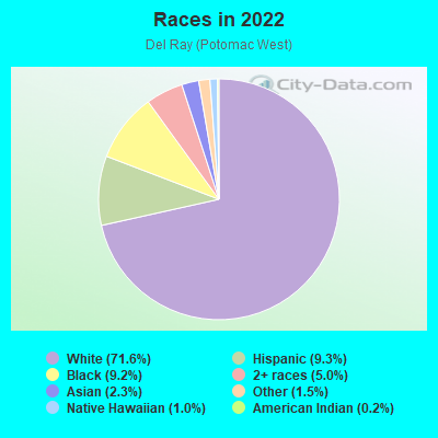
- 15,22471.6%White
- 1,9759.3%Hispanic or Latino
- 1,9489.2%Black
- 1,0625.0%Two or more races
- 4862.3%Asian
- 3241.5%Some other race
- 2151.0%Native Hawaiian and Other
Pacific Islander - 330.2%American Indian
Distribution of median household income
![Distribution of median household income]()
- 260Less than $10,000
- 802$10,000 to $19,999
- 423$20,000 to $29,999
- 743$30,000 to $39,999
- 1,226$40,000 to $49,999
- 469$50,000 to $59,999
- 614$60,000 to $74,999
- 1,182$75,000 to $99,999
- 1,257$100,000 to $124,999
- 553$125,000 to $149,999
- 1,165$150,000 to $199,999
- 3,588$200,000 or more

Distribution of owner-occupied house/condo value
![Distribution of owner-occupied house/condo value]()
- 163Less than $50,000
- 160$50,000 to $99,999
- 371$200,000 to $249,999
- 350$250,000 to $299,999
- 270$300,000 to $399,999
- 336$400,000 to $499,999
- 1,680$500,000 to $749,999
- 1,767$750,000 to $999,999
- 2,072$1,000,000 or more

Distribution of rent paid by renters
![Distribution of rent paid by renters]()
- 109Less than $100
- 235$200 to $299
- 218$500 to $599
- 1,835$600 to $699
- 233$700 to $799
- 893$900 to $999
- 490$1,000 to $1,249
- 749$1,250 to $1,499
- 1,439$1,500 to $1,999
- 2,679$2,000 or more

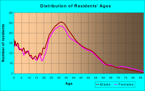
| Males: | 10,264 |
| Females: | 10,125 |
Males:
| This neighborhood: | 39.6 years |
| Whole city: | 36.8 years |
| This neighborhood: | 38.1 years |
| Whole city: | 38.7 years |
Average household size:
| Del Ray (Potomac West): | 3.1 people |
| Alexandria: | 21.0 people |
Percentage of family households:
| Del Ray (Potomac West): | 46.4% |
| Alexandria: | 35.2% |
| Here: | 47.4% |
| Alexandria: | 34.2% |
Percentage of married-couple families with children (among all households):
| Del Ray (Potomac West): | 40.1% |
| Alexandria: | 36.1% |
Percentage of single-mother households (among all households):
| Del Ray (Potomac West): | 5.8% |
| Alexandria: | 10.5% |
Percentage of never married males 15 years old and over:
Percentage of never married females 15 years old and over:
| Del Ray (Potomac West): | 17.0% |
| Alexandria: | 18.9% |
Percentage of never married females 15 years old and over:
| Del Ray (Potomac West): | 18.2% |
| city: | 21.0% |
Percentage of people that speak English not well or not at all:
| Del Ray (Potomac West): | 2.0% |
| Alexandria: | 4.7% |
Percentage of people born in this state:
Percentage of people born in another U.S. state:
Percentage of native residents but born outside the U.S.:
Percentage of foreign born residents:
| Here: | 25.8% |
| Alexandria: | 24.1% |
Percentage of people born in another U.S. state:
| Del Ray (Potomac West): | 63.8% |
| Alexandria: | 50.3% |
Percentage of native residents but born outside the U.S.:
| Here: | 2.2% |
| city: | 1.8% |
Percentage of foreign born residents:
| Here: | 8.2% |
| Alexandria: | 23.7% |
Owner-occupied
Renter-occupied

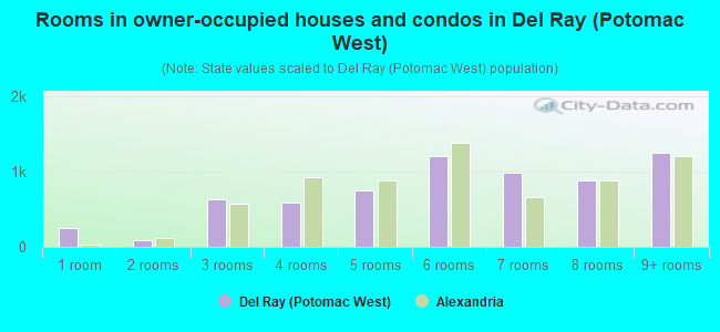
- Rooms in owner-occupied houses and condos in Del Ray <
> - 2551 room
- 952 rooms
- 6353 rooms
- 5924 rooms
- 7445 rooms
- 1,2096 rooms
- 9807 rooms
- 8838 rooms
- 1,2489+ rooms
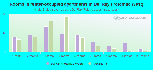
- Rooms in renter-occupied apartments in Del Ray <
> - 7981 room
- 8932 rooms
- 1,3623 rooms
- 9604 rooms
- 8975 rooms
- 5426 rooms
- 3057 rooms
- 4648 rooms
- 1659+ rooms
Owner-occupied
Renter-occupied
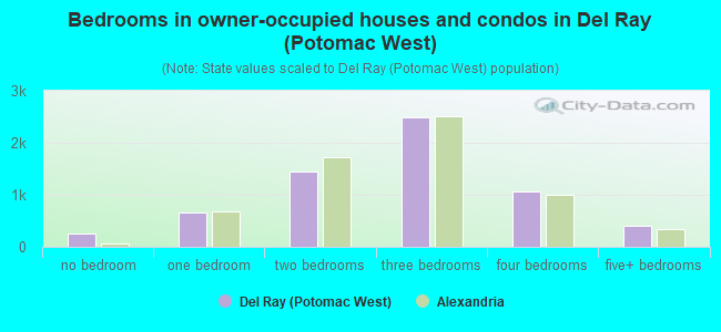
- Bedrooms in owner-occupied houses and condos in Del Ray <
> - 255no bedroom
- 6551 bedroom
- 1,4402 bedrooms
- 2,4923 bedrooms
- 1,0634 bedrooms
- 4065+ bedrooms
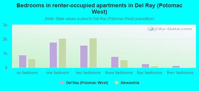
- Bedrooms in renter-occupied apartments in Del Ray <
> - 887no bedroom
- 1,7861 bedroom
- 1,5812 bedrooms
- 7913 bedrooms
- 2704 bedrooms
- 1555+ bedrooms
Average number of cars or other vehicles available in houses/condos:
Average number of cars or other vehicles available in apartments:
| This neighborhood: | |
| Alexandria: |
Average number of cars or other vehicles available in apartments:
| Here: | 1.3 |
| city: | 1.2 |
Percentage of units with a mortgage:
| Del Ray (Potomac West): | 79.9% |
| Alexandria: | 77.0% |
Average estimated value of detached houses in 2022 (31.6% of all units):
| Del Ray (Potomac West): | $643,791 |
| Virginia: | $472,865 |
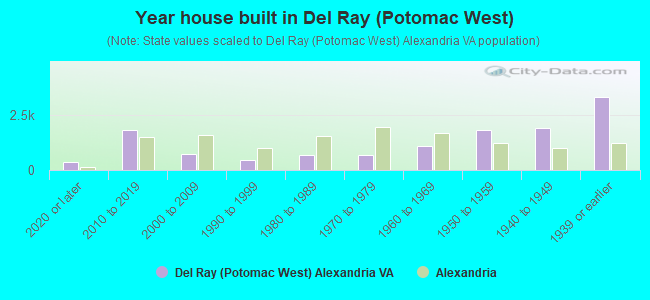
- Year house built in Del Ray <
> - 3802020 or later
- 1,8162010 to 2019
- 7192000 to 2009
- 4761990 to 1999
- 7011980 to 1989
- 6751970 to 1979
- 1,0751960 to 1969
- 1,8301950 to 1959
- 1,9141940 to 1949
- 3,3211939 or earlier
City-data.com crime index for city in 2020 (higher means more crime):
| City: | 129.5 |
| U.S. average: | 219.5 |
Travel time to work (commute)
![Travel time to work (commute)]()
- 173Less than 5 minutes
- 3535 to 9 minutes
- 1,07810 to 14 minutes
- 1,33515 to 19 minutes
- 1,19520 to 24 minutes
- 61825 to 29 minutes
- 1,85230 to 34 minutes
- 48935 to 39 minutes
- 61740 to 44 minutes
- 1,25345 to 59 minutes
- 60860 to 89 minutes
- 5590 or more minutes

Means of transportation to work
![Means of transportation to work]()
- 44.0%5,845Drove a car alone
- 7.0%935Carpooled
- 2.8%373Bus
- 9.4%1,254Subway or elevated rail
- 1.3%176Long-distance train or commuter rail
- 1.2%158Light rail, streetcar or trolley
- 2.7%362Taxi
- 2.4%324Motorcycle
- 4.5%603Bicycle
- 5.5%734Walked
- 1.6%209Other means
- 27.7%3,675Worked at home

Time leaving home to go to work
![Time leaving home to go to work]()
- 12212:00 a.m. to 4:59 a.m.
- 1125:00 a.m. to 5:29 a.m.
- 3255:30 a.m. to 5:59 a.m.
- 6446:00 a.m. to 6:29 a.m.
- 5806:30 a.m. to 6:59 a.m.
- 1,5817:00 a.m. to 7:29 a.m.
- 1,5977:30 a.m. to 7:59 a.m.
- 1,9068:00 a.m. to 8:29 a.m.
- 9898:30 a.m. to 8:59 a.m.
- 7319:00 a.m. to 9:59 a.m.
- 37510:00 a.m. to 10:59 a.m.
- 18011:00 a.m. to 11:59 a.m.
- 26612:00 p.m. to 3:59 p.m.
- 3004:00 p.m. to 11:59 p.m.

Occupations of males:
- Percentage of males in management occupations (except farmers):
Here: 21.9% city: 16.3%
- Percentage of males in business and financial operations occupations:
Here: 13.8% city: 10.7%
- Percentage of males in computer and mathematical occupations:
Here: 11.9% city: 9.6%
- Percentage of males in architecture and engineering occupations:
Here: 4.4% city: 4.0%
- Percentage of males in life, physical, and social science occupations:
Here: 2.8% city: 2.1%
- Percentage of males in legal occupations:
Here: 8.2% city: 6.0%
- Percentage of males in education, training, and library occupations:
Here: 3.6% city: 3.9%
- Percentage of males in arts, design, entertainment, sports, and media occupations:
Here: 3.7% city: 3.8%
- Percentage of males in healthcare practitioners and technical occupations:
Here: 1.4% city: 2.0%
- Percentage of males in service occupations:
Here: 8.1% city: 11.2%
- Percentage of males in sales and office occupations:
Here: 10.4% city: 11.0%
- Percentage of males in construction, extraction, and maintenance occupations:
Here: 2.1% city: 5.5%
- Percentage of males in transportation occupations:
Here: 3.4% city: 5.9%
Occupations of females:
- Percentage of females in management occupations (except farmers):
Here: 20.5% city: 15.9%
- Percentage of females in business and financial operations occupations:
Here: 12.9% city: 13.4%
- Percentage of females in computer and mathematical occupations:
Here: 7.0% city: 6.5%
- Percentage of females in life, physical, and social science occupations:
Here: 5.4% city: 2.4%
- Percentage of females in community and social services occupations:
Here: 3.2% city: 2.1%
- Percentage of females in legal occupations:
Here: 9.7% city: 5.8%
- Percentage of females in education, training, and library occupations:
Here: 7.9% city: 8.7%
- Percentage of females in arts, design, entertainment, sports, and media occupations:
Here: 5.2% city: 4.0%
- Percentage of females in healthcare practitioners and technical occupations:
Here: 5.8% city: 5.6%
- Percentage of females in service occupations:
Here: 11.5% city: 16.5%
- Percentage of females in sales and office occupations:
Here: 9.1% city: 15.5%
Percentage of people 16-64 in Armed Forces:
| Del Ray (Potomac West): | 3.3% |
| Alexandria: | 3.8% |
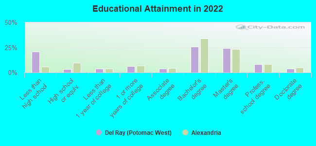
Education in this neighborhood (subdivision or community):
- Percentage of people 3 years and older in K-12 schools:
Del Ray (Potomac West): 16.9% Alexandria: 11.9%
- Percentage of people 3 years and older in undergraduate colleges:
Del Ray (Potomac West): 4.0% Alexandria: 2.7%
- Percentage of people 3 years and older in grad. or professional schools:
Del Ray (Potomac West): 4.7% Alexandria: 3.8%
- Percentage of students K-12 enrolled in private schools:
Del Ray (Potomac West): 62.7% Alexandria: 15.4%
Percentage of population below poverty level:
| Del Ray (Potomac West): | 3.7% |
| Alexandria: | 8.1% |
Percentage of married-couple families with both working:
| Del Ray (Potomac West): | 88.8% |
| Alexandria: | 81.2% |
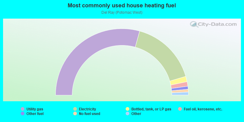
- 58.6%Utility gas
- 32.3%Electricity
- 2.6%Bottled, tank, or LP gas
- 2.2%Fuel oil, kerosene, etc.
- 1.5%Other fuel
- 1.3%No fuel used
- 0.9%Coal or coke
- 0.6%Solar energy
Highways in this neighborhood:
Jefferson Davis Hwy (US Hwy 1)
Length: 1.10 miles
Direction: N-S
Address range: 2100 to 3999
Direction: N-S
Address range: 2100 to 3999
State Rte 120 (W Glebe Rd)
Length: 0.53 miles
Direction: E-W
Address range: 1 to 998
Direction: E-W
Address range: 1 to 998
State Rte 120 (E Glebe Rd)
Length: 0.50 miles
Directions: E-W, SE-NW
Address range: 1 to 499
Directions: E-W, SE-NW
Address range: 1 to 499
Roads and streets:
Mount Vernon Ave
Length: 2.53 miles
Directions: E-W, N-S, SE-NW, SW-NE
Address range: 1 to 4165
Directions: E-W, N-S, SE-NW, SW-NE
Address range: 1 to 4165
Commonwealth Ave
Length: 2.38 miles
Directions: N-S, SE-NW, SW-NE
Address range: 16 to 3699
Directions: N-S, SE-NW, SW-NE
Address range: 16 to 3699
Dewitt Ave
Length: 0.95 miles
Direction: N-S
Address range: 1200 to 2899
Direction: N-S
Address range: 1200 to 2899
E Bellefonte Ave
Length: 0.87 miles
Direction: E-W
Address range: 1 to 599
Direction: E-W
Address range: 1 to 599
E Howell Ave
Length: 0.87 miles
Direction: E-W
Address range: 1 to 599
Direction: E-W
Address range: 1 to 599
E Windsor Ave
Length: 0.85 miles
Direction: E-W
Address range: 1 to 599
Direction: E-W
Address range: 1 to 599
E Custis Ave
Length: 0.82 miles
Direction: E-W
Address range: 1 to 599
Direction: E-W
Address range: 1 to 599
Leslie Ave
Length: 0.80 miles
Directions: E-W, N-S, SW-NE
Address range: 1200 to 2602
Directions: E-W, N-S, SW-NE
Address range: 1200 to 2602
E Monroe Ave
Length: 0.79 miles
Directions: E-W, N-S
Address range: 1 to 573
Directions: E-W, N-S
Address range: 1 to 573
E Nelson Ave
Length: 0.71 miles
Direction: E-W
Address range: 1 to 599
Direction: E-W
Address range: 1 to 599
E Alexandria Ave
Length: 0.67 miles
Direction: E-W
Address range: 1 to 599
Direction: E-W
Address range: 1 to 599
E Luray Ave
Length: 0.66 miles
Direction: E-W
Address range: 1 to 599
Direction: E-W
Address range: 1 to 599
E Glendale Ave
Length: 0.66 miles
Directions: E-W, SW-NE
Address range: 5 to 599
Directions: E-W, SW-NE
Address range: 5 to 599
E Randolph Ave
Length: 0.62 miles
Directions: E-W, SE-NW
Address range: 100 to 2698
Directions: E-W, SE-NW
Address range: 100 to 2698
E del Ray Ave
Length: 0.60 miles
Direction: E-W
Address range: 1 to 499
Direction: E-W
Address range: 1 to 499
E Mount Ida Ave
Length: 0.59 miles
Directions: E-W, SE-NW
Address range: 200 to 599
Directions: E-W, SE-NW
Address range: 200 to 599
E Mason Ave
Length: 0.59 miles
Direction: E-W
Address range: 1 to 499
Direction: E-W
Address range: 1 to 499
Hume Ave
Length: 0.58 miles
Direction: E-W
Address range: 100 to 499
Direction: E-W
Address range: 100 to 499
E Braddock Rd
Length: 0.57 miles
Directions: E-W, SE-NW
Address range: 1 to 698
Directions: E-W, SE-NW
Address range: 1 to 698
E Raymond Ave
Length: 0.57 miles
Direction: E-W
Address range: 100 to 499
Direction: E-W
Address range: 100 to 499
E Clifford Ave
Length: 0.54 miles
Directions: E-W, SW-NE
Address range: 1 to 499
Directions: E-W, SW-NE
Address range: 1 to 499
Holly St
Length: 0.54 miles
Directions: E-W, N-S, SE-NW, SW-NE
Address range: 2700 to 3599
Directions: E-W, N-S, SE-NW, SW-NE
Address range: 2700 to 3599
E Duncan Ave
Length: 0.49 miles
Directions: E-W, N-S, SW-NE
Address range: 200 to 599
Directions: E-W, N-S, SW-NE
Address range: 200 to 599
Four Mile Rd
Length: 0.45 miles
Directions: E-W, SE-NW, SW-NE
Address range: 400 to 905
Directions: E-W, SE-NW, SW-NE
Address range: 400 to 905
Hancock Ave
Length: 0.43 miles
Direction: N-S
Address range: 1200 to 2099
Direction: N-S
Address range: 1200 to 2099
Mosby St
Length: 0.42 miles
Directions: E-W, N-S, SE-NW, SW-NE
Address range: 2700 to 3199
Directions: E-W, N-S, SE-NW, SW-NE
Address range: 2700 to 3199
Wayne St
Length: 0.42 miles
Direction: N-S
Address range: 600 to 1599
Direction: N-S
Address range: 600 to 1599
E Oxford Ave
Length: 0.41 miles
Direction: E-W
Address range: 1 to 399
Direction: E-W
Address range: 1 to 399
Montrose Ave
Length: 0.41 miles
Directions: E-W, N-S, SW-NE
Address range: 600 to 3399
Directions: E-W, N-S, SW-NE
Address range: 600 to 3399
Ramsey St
Length: 0.41 miles
Direction: N-S
Address range: 600 to 1399
Direction: N-S
Address range: 600 to 1399
E Spring St
Length: 0.39 miles
Direction: E-W
Address range: 1 to 399
Direction: E-W
Address range: 1 to 399
W Mount Ida Ave
Length: 0.38 miles
Directions: E-W, SE-NW
Address range: 1 to 217
Directions: E-W, SE-NW
Address range: 1 to 217
E Oak St
Length: 0.38 miles
Direction: E-W
Address range: 1 to 399
Direction: E-W
Address range: 1 to 399
E Reed Ave
Length: 0.37 miles
Direction: E-W
Address range: 1 to 199
Direction: E-W
Address range: 1 to 199
Clyde Ave
Length: 0.37 miles
Direction: N-S
Address range: 1900 to 2599
Direction: N-S
Address range: 1900 to 2599
E Walnut St
Length: 0.37 miles
Direction: E-W
Address range: 4 to 199
Direction: E-W
Address range: 4 to 199
Little St
Length: 0.35 miles
Directions: N-S, SW-NE
Address range: 300 to 999
Directions: N-S, SW-NE
Address range: 300 to 999
Landover St
Length: 0.34 miles
Directions: N-S, SE-NW, SW-NE
Address range: 2900 to 3399
Directions: N-S, SE-NW, SW-NE
Address range: 2900 to 3399
Laverne Ave
Length: 0.34 miles
Direction: E-W
Address range: 200 to 499
Direction: E-W
Address range: 200 to 499
Ashby St
Length: 0.34 miles
Directions: E-W, SW-NE
Address range: 1 to 399
Directions: E-W, SW-NE
Address range: 1 to 399
E Maple St
Length: 0.34 miles
Direction: E-W
Address range: 1 to 199
Direction: E-W
Address range: 1 to 199
Kennedy St
Length: 0.34 miles
Directions: E-W, N-S, SE-NW, SW-NE
Address range: 1 to 199
Directions: E-W, N-S, SE-NW, SW-NE
Address range: 1 to 199
Sycamore St
Length: 0.33 miles
Directions: N-S, SW-NE
Address range: 2600 to 2999
Directions: N-S, SW-NE
Address range: 2600 to 2999
Wesmond Dr
Length: 0.33 miles
Directions: N-S, SE-NW
Address range: 100 to 365
Directions: N-S, SE-NW
Address range: 100 to 365
W Reed Ave
Length: 0.33 miles
Direction: E-W
Address range: 1 to 199
Direction: E-W
Address range: 1 to 199
Hickory St
Length: 0.32 miles
Directions: N-S, SW-NE
Address range: 2700 to 3099
Directions: N-S, SW-NE
Address range: 2700 to 3099
Stewart Ave
Length: 0.31 miles
Direction: E-W
Address range: 100 to 399
Direction: E-W
Address range: 100 to 399
Adams Ave
Length: 0.30 miles
Direction: E-W
Address range: 100 to 399
Direction: E-W
Address range: 100 to 399
Luna Park Dr
Length: 0.29 miles
Direction: E-W
Address range: 1 to 299
Direction: E-W
Address range: 1 to 299
Lynnhaven Dr
Length: 0.28 miles
Direction: E-W
Address range: 100 to 299
Direction: E-W
Address range: 100 to 299
E Linden St
Length: 0.28 miles
Direction: E-W
Address range: 1 to 199
Direction: E-W
Address range: 1 to 199
E Masonic View Ave
Length: 0.28 miles
Direction: E-W
Address range: 1 to 299
Direction: E-W
Address range: 1 to 299
Newton St
Length: 0.28 miles
Direction: N-S
Address range: 1000 to 1599
Direction: N-S
Address range: 1000 to 1599
Calvert Ave
Length: 0.25 miles
Direction: E-W
Address range: 300 to 499
Direction: E-W
Address range: 300 to 499
la Grande Ave
Length: 0.25 miles
Direction: N-S
Address range: 1900 to 2399
Direction: N-S
Address range: 1900 to 2399
E Rosemont Ave
Length: 0.24 miles
Direction: E-W
Address range: 1 to 199
Direction: E-W
Address range: 1 to 199
Evans Ln
Length: 0.24 miles
Directions: E-W, N-S, SE-NW
Address range: 100 to 399
Directions: E-W, N-S, SE-NW
Address range: 100 to 399
Charles Ave
Length: 0.24 miles
Directions: E-W, N-S, SE-NW, SW-NE
Address range: 3800 to 3999
Directions: E-W, N-S, SE-NW, SW-NE
Address range: 3800 to 3999
Edison St
Length: 0.23 miles
Directions: N-S, SE-NW, SW-NE
Address range: 3432 to 3898
Directions: N-S, SE-NW, SW-NE
Address range: 3432 to 3898
E Uhler Ave
Length: 0.22 miles
Direction: E-W
Address range: 1 to 299
Direction: E-W
Address range: 1 to 299
Swann Ave
Length: 0.21 miles
Direction: E-W
Address range: 300 to 499
Direction: E-W
Address range: 300 to 499
Aspen St
Length: 0.20 miles
Directions: E-W, SE-NW
Address range: 200 to 331
Directions: E-W, SE-NW
Address range: 200 to 331
Sanborn Pl
Length: 0.20 miles
Directions: E-W, N-S, SE-NW, SW-NE
Address range: 100 to 199
Directions: E-W, N-S, SE-NW, SW-NE
Address range: 100 to 199
Sanford St
Length: 0.19 miles
Directions: N-S, SW-NE
Address range: 2300 to 2599
Directions: N-S, SW-NE
Address range: 2300 to 2599
E Myrtle St
Length: 0.19 miles
Direction: E-W
Address range: 1 to 99
Direction: E-W
Address range: 1 to 99
E Chapman St
Length: 0.18 miles
Direction: E-W
Address range: 1 to 99
Direction: E-W
Address range: 1 to 99
Leadbeater St
Length: 0.18 miles
Direction: E-W
Address range: 1 to 199
Direction: E-W
Address range: 1 to 199
Wilson Ave
Length: 0.18 miles
Directions: E-W, N-S, SW-NE
Address range: 3100 to 3599
Directions: E-W, N-S, SW-NE
Address range: 3100 to 3599
Terrett Ave
Length: 0.17 miles
Direction: N-S
Address range: 2400 to 2699
Direction: N-S
Address range: 2400 to 2699
Brighton Ct
Length: 0.17 miles
Directions: E-W, N-S, SE-NW, SW-NE
Address range: 3800 to 3899
Directions: E-W, N-S, SE-NW, SW-NE
Address range: 3800 to 3899
E Cliff St
Length: 0.17 miles
Direction: E-W
Address range: 1 to 199
Direction: E-W
Address range: 1 to 199
W Braddock Rd
Length: 0.16 miles
Directions: E-W, SE-NW
Address range: 1 to 99
Directions: E-W, SE-NW
Address range: 1 to 99
Dale St
Length: 0.16 miles
Direction: E-W
Address range: 1 to 199
Direction: E-W
Address range: 1 to 199
W del Ray Ave
Length: 0.16 miles
Direction: E-W
Address range: 1 to 64
Direction: E-W
Address range: 1 to 64
Murrays Ave
Length: 0.16 miles
Directions: N-S, SE-NW
Address range: 300 to 499
Directions: N-S, SE-NW
Address range: 300 to 499
Wyatt Ave
Length: 0.16 miles
Direction: E-W
Address range: 1 to 99
Direction: E-W
Address range: 1 to 99
W Uhler Ave
Length: 0.16 miles
Direction: E-W
Address range: 1 to 99
Direction: E-W
Address range: 1 to 99
W Caton Ave
Length: 0.16 miles
Direction: E-W
Address range: 1 to 99
Direction: E-W
Address range: 1 to 99
Bruce St
Length: 0.16 miles
Directions: E-W, N-S, SE-NW
Address range: 3800 to 3999
Directions: E-W, N-S, SE-NW
Address range: 3800 to 3999
Burgess Ave
Length: 0.16 miles
Directions: E-W, N-S, SE-NW, SW-NE
Address range: 200 to 299
Directions: E-W, N-S, SE-NW, SW-NE
Address range: 200 to 299
Florence Dr
Length: 0.15 miles
Directions: E-W, SW-NE
Address range: 3800 to 3899
Directions: E-W, SW-NE
Address range: 3800 to 3899
Groves Ave
Length: 0.15 miles
Direction: E-W
Address range: 1 to 99
Direction: E-W
Address range: 1 to 99
Forrest St
Length: 0.15 miles
Direction: E-W
Address range: 1 to 99
Direction: E-W
Address range: 1 to 99
Old Dominion Blvd
Length: 0.15 miles
Directions: N-S, SW-NE
Address range: 3800 to 3999
Directions: N-S, SW-NE
Address range: 3800 to 3999
Ancell St
Length: 0.14 miles
Directions: E-W, N-S, SE-NW
Address range: 1 to 99
Directions: E-W, N-S, SE-NW
Address range: 1 to 99
Mark Dr
Length: 0.14 miles
Directions: E-W, N-S, SE-NW, SW-NE
Address range: 3700 to 3799
Directions: E-W, N-S, SE-NW, SW-NE
Address range: 3700 to 3799
W Luray Ave
Length: 0.14 miles
Direction: E-W
Address range: 1 to 199
Direction: E-W
Address range: 1 to 199
Tennessee Ave
Length: 0.14 miles
Directions: E-W, SE-NW, SW-NE
Address range: 200 to 299
Directions: E-W, SE-NW, SW-NE
Address range: 200 to 299
W Windsor Ave
Length: 0.14 miles
Direction: E-W
Address range: 1 to 99
Direction: E-W
Address range: 1 to 99
Herbert St
Length: 0.13 miles
Direction: E-W
Address range: 2 to 199
Direction: E-W
Address range: 2 to 199
Guthrie Ave
Length: 0.12 miles
Directions: E-W, SE-NW
Address range: 200 to 299
Directions: E-W, SE-NW
Address range: 200 to 299
W Howell Ave
Length: 0.11 miles
Direction: E-W
Address range: 1 to 99
Direction: E-W
Address range: 1 to 99
Helen St
Length: 0.11 miles
Direction: SW-NE
Address range: 2500 to 3339
Direction: SW-NE
Address range: 2500 to 3339
Oakville St
Length: 0.10 miles
Direction: N-S
Address range: 2400 to 2599
Direction: N-S
Address range: 2400 to 2599
Turner Ave
Length: 0.10 miles
Direction: N-S
Address range: 500 to 699
Direction: N-S
Address range: 500 to 699
W Cliff St
Length: 0.10 miles
Direction: E-W
Address range: 1350 to 1399
Direction: E-W
Address range: 1350 to 1399
Notabene Dr
Length: 0.10 miles
Directions: N-S, SE-NW, SW-NE
Address range: 600 to 699
Directions: N-S, SE-NW, SW-NE
Address range: 600 to 699
Hemlock Ave
Length: 0.10 miles
Direction: SW-NE
Address range: 2700 to 2799
Direction: SW-NE
Address range: 2700 to 2799
Burke Ave
Length: 0.10 miles
Direction: N-S
Address range: 2300 to 2499
Direction: N-S
Address range: 2300 to 2499
Manning St
Length: 0.09 miles
Directions: N-S, SE-NW
Address range: 3000 to 3099
Directions: N-S, SE-NW
Address range: 3000 to 3099
W Bellefonte Ave
Length: 0.09 miles
Direction: E-W
Address range: 1 to 99
Direction: E-W
Address range: 1 to 99
Price St
Length: 0.09 miles
Direction: N-S
Address range: 1700 to 1799
Direction: N-S
Address range: 1700 to 1799
N Cliff St
Length: 0.09 miles
Directions: N-S, SW-NE
Address range: 1700 to 1899
Directions: N-S, SW-NE
Address range: 1700 to 1899
Auburn Ct
Length: 0.08 miles
Direction: SW-NE
Address range: 1 to 99
Direction: SW-NE
Address range: 1 to 99
Fannon St
Length: 0.08 miles
Direction: E-W
Address range: 400 to 499
Direction: E-W
Address range: 400 to 499
Courtland Cir
Length: 0.08 miles
Directions: E-W, N-S, SE-NW, SW-NE
Directions: E-W, N-S, SE-NW, SW-NE
W Monroe Ave
Length: 0.07 miles
Direction: E-W
Address range: 1 to 99
Direction: E-W
Address range: 1 to 99
W Nelson Ave
Length: 0.07 miles
Direction: E-W
Address range: 1 to 99
Direction: E-W
Address range: 1 to 99
W Mason Ave
Length: 0.07 miles
Direction: E-W
Address range: 1 to 99
Direction: E-W
Address range: 1 to 99
W Alexandria Ave
Length: 0.07 miles
Direction: E-W
Address range: 1 to 99
Direction: E-W
Address range: 1 to 99
Gentry Ave
Length: 0.06 miles
Direction: E-W
Address range: 200 to 250
Direction: E-W
Address range: 200 to 250
E Marsteller St
Length: 0.05 miles
Direction: N-S
Address range: 1 to 99
Direction: N-S
Address range: 1 to 99
W Glendale Ave
Length: 0.04 miles
Direction: E-W
Direction: E-W
W Uhler Ter
Length: 0.04 miles
Directions: E-W, N-S, SE-NW
Address range: 100 to 199
Directions: E-W, N-S, SE-NW
Address range: 100 to 199
4th St
Length: 0.04 miles
Direction: N-S
Address range: 1400 to 1450
Direction: N-S
Address range: 1400 to 1450
Fulton St
Length: 0.04 miles
Directions: E-W, N-S, SE-NW
Address range: 3000 to 3099
Directions: E-W, N-S, SE-NW
Address range: 3000 to 3099
Shorter Ln
Length: 0.03 miles
Direction: SE-NW
Address range: 501 to 599
Direction: SE-NW
Address range: 501 to 599
W Custis Ave
Length: 0.03 miles
Direction: E-W
Address range: 1 to 7
Direction: E-W
Address range: 1 to 7
Rosemont Ave
Length: 0.03 miles
Directions: N-S, SE-NW
Directions: N-S, SE-NW
Railroad features:
Csx RR
Length: 0.68 miles
Direction: SW-NE
Direction: SW-NE