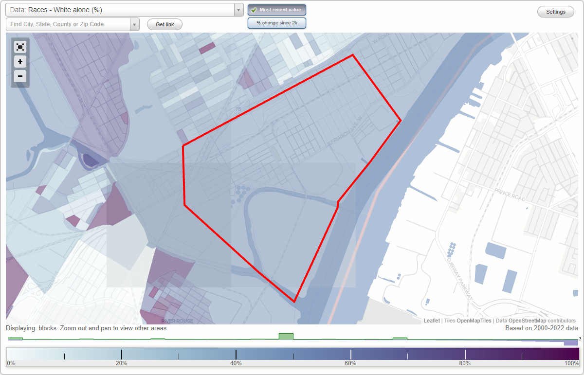
Delray neighborhood in Detroit, Michigan (MI), 48209 detailed profile
Settings
X

Business Search - 14 Million verified businesses
Area: 2.294 square miles
Population: 22,822
Population density:
| Delray: | 9,947 people per square mile |
| Detroit: | 4,471 people per square mile |

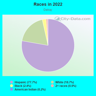
- 17,92877.7%Hispanic or Latino
- 4,31718.7%White
- 5542.4%Black
- 2130.9%Two or more races
- 570.2%American Indian
Median household income in 2022:
| Delray: | $38,684 |
| Detroit: | $36,453 |
Distribution of median household income
![Distribution of median household income]()
- 627Less than $10,000
- 1,013$10,000 to $19,999
- 812$20,000 to $29,999
- 2,032$30,000 to $39,999
- 3,478$40,000 to $49,999
- 536$50,000 to $59,999
- 464$60,000 to $74,999
- 536$75,000 to $99,999
- 631$100,000 to $124,999
- 27$125,000 to $149,999
- 878$150,000 to $199,999

Distribution of owner-occupied house/condo value
![Distribution of owner-occupied house/condo value]()
- 833Less than $50,000
- 2,519$50,000 to $99,999
- 1,605$100,000 to $149,999
- 113$150,000 to $199,999
- 134$200,000 to $249,999
- 179$300,000 to $399,999
- 88$400,000 to $499,999
- 134$500,000 to $749,999
- 708$1,000,000 or more

Distribution of rent paid by renters
![Distribution of rent paid by renters]()
- 230$100 to $199
- 200$300 to $399
- 266$400 to $499
- 2,321$500 to $599
- 1,835$600 to $699
- 597$700 to $799
- 183$800 to $899
- 1,204$900 to $999
- 93$1,000 to $1,249
- 41$1,250 to $1,499
- 62$1,500 to $1,999

Median rent in 2022:
| Delray: | $624 |
| Detroit: | $735 |
| Males: | 11,264 |
| Females: | 11,558 |
Males:
| This neighborhood: | 34.9 years |
| Whole city: | 33.9 years |
| This neighborhood: | 25.7 years |
| Whole city: | 37.0 years |
Average household size:
| Delray: | 2.7 people |
| Detroit: | 2.5 people |
Percentage of family households:
| Delray: | 71.4% |
| Detroit: | 37.4% |
| Here: | 45.7% |
| Detroit: | 17.7% |
Percentage of married-couple families with children (among all households):
| Delray: | 30.7% |
| Detroit: | 12.9% |
Percentage of single-mother households (among all households):
| Delray: | 5.9% |
| Detroit: | 22.7% |
Percentage of never married males 15 years old and over:
Percentage of never married females 15 years old and over:
| Delray: | 25.4% |
| Detroit: | 28.3% |
Percentage of never married females 15 years old and over:
| Delray: | 17.9% |
| city: | 30.2% |
Percentage of people that speak English not well or not at all:
| Delray: | 16.4% |
| Detroit: | 2.8% |
Percentage of people born in this state:
Percentage of people born in another U.S. state:
Percentage of native residents but born outside the U.S.:
Percentage of foreign born residents:
| Here: | 56.4% |
| Detroit: | 77.9% |
Percentage of people born in another U.S. state:
| Delray: | 10.8% |
| Detroit: | 15.0% |
Percentage of native residents but born outside the U.S.:
| Here: | 4.2% |
| city: | 1.0% |
Percentage of foreign born residents:
| Here: | 28.6% |
| Detroit: | 6.1% |
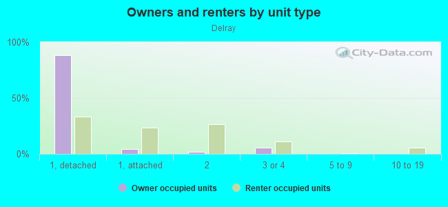
Owner-occupied
Renter-occupied

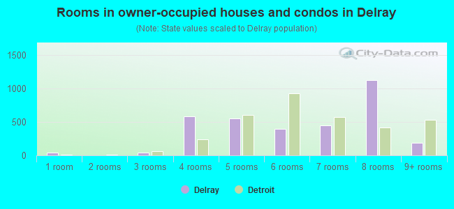
- Rooms in owner-occupied houses and condos in Delray
- 401 room
- 02 rooms
- 463 rooms
- 5824 rooms
- 5545 rooms
- 4016 rooms
- 4507 rooms
- 1,1278 rooms
- 1839+ rooms
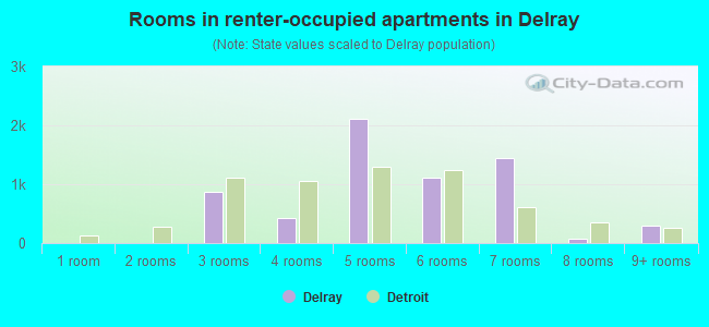
- Rooms in renter-occupied apartments in Delray
- 01 room
- 02 rooms
- 8773 rooms
- 4204 rooms
- 2,1175 rooms
- 1,1086 rooms
- 1,4527 rooms
- 668 rooms
- 2969+ rooms
Owner-occupied
Renter-occupied
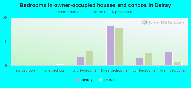
- Bedrooms in owner-occupied houses and condos in Delray
- 40no bedroom
- 01 bedroom
- 3562 bedrooms
- 1,6713 bedrooms
- 3034 bedrooms
- 5805+ bedrooms
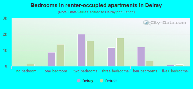
- Bedrooms in renter-occupied apartments in Delray
- 0no bedroom
- 8771 bedroom
- 2,0062 bedrooms
- 1,1653 bedrooms
- 1,2034 bedrooms
- 665+ bedrooms
Average number of cars or other vehicles available in houses/condos:
Average number of cars or other vehicles available in apartments:
| This neighborhood: | 1.7 |
| Detroit: | 1.5 |
Average number of cars or other vehicles available in apartments:
| Here: | 1.4 |
| city: | 0.9 |
Percentage of units with a mortgage:
| Delray: | 14.8% |
| Detroit: | 34.2% |
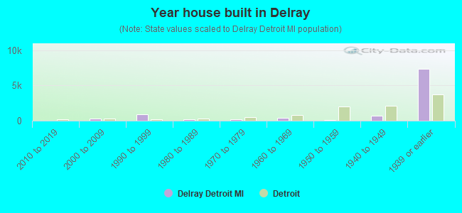
- Year house built in Delray
- 02020 or later
- 02010 to 2019
- 2942000 to 2009
- 9361990 to 1999
- 2481980 to 1989
- 2291970 to 1979
- 4201960 to 1969
- 761950 to 1959
- 7391940 to 1949
- 7,3291939 or earlier
City-data.com crime index for city in 2020 (higher means more crime):
| City: | 796.8 |
| U.S. average: | 219.5 |
Travel time to work (commute)
![Travel time to work (commute)]()
- 337Less than 5 minutes
- 4255 to 9 minutes
- 49210 to 14 minutes
- 1,13515 to 19 minutes
- 1,20420 to 24 minutes
- 43825 to 29 minutes
- 92630 to 34 minutes
- 9735 to 39 minutes
- 37440 to 44 minutes
- 1,24245 to 59 minutes
- 24060 to 89 minutes

Means of transportation to work
![Means of transportation to work]()
- 80.4%6,780Drove a car alone
- 19.6%1,653Carpooled
- 1.7%144Bus
- 0.4%35Bicycle
- 3.1%259Other means
- 0.3%29Worked at home

Time leaving home to go to work
![Time leaving home to go to work]()
- 39412:00 a.m. to 4:59 a.m.
- 4085:00 a.m. to 5:29 a.m.
- 8295:30 a.m. to 5:59 a.m.
- 6666:00 a.m. to 6:29 a.m.
- 2686:30 a.m. to 6:59 a.m.
- 5717:00 a.m. to 7:29 a.m.
- 7707:30 a.m. to 7:59 a.m.
- 1958:00 a.m. to 8:29 a.m.
- 4618:30 a.m. to 8:59 a.m.
- 4629:00 a.m. to 9:59 a.m.
- 37810:00 a.m. to 10:59 a.m.
- 17411:00 a.m. to 11:59 a.m.
- 47512:00 p.m. to 3:59 p.m.
- 4194:00 p.m. to 11:59 p.m.

Occupations of males:
- Percentage of males in management occupations (except farmers):
Here: 2.4% city: 5.6%
- Percentage of males in service occupations:
Here: 28.4% city: 21.4%
- Percentage of males in sales and office occupations:
Here: 8.9% city: 11.8%
- Percentage of males in construction, extraction, and maintenance occupations:
Here: 19.2% city: 7.9%
- Percentage of males in production occupations:
Here: 11.4% city: 14.4%
- Percentage of males in transportation occupations:
Here: 5.1% city: 8.3%
- Percentage of males in material moving occupations:
Here: 19.6% city: 11.0%
Occupations of females:
- Percentage of females in management occupations (except farmers):
Here: 1.1% city: 6.9%
- Percentage of females in computer and mathematical occupations:
Here: 3.0% city: 1.4%
- Percentage of females in legal occupations:
Here: 2.7% city: 0.8%
- Percentage of females in healthcare practitioners and technical occupations:
Here: 4.4% city: 6.4%
- Percentage of females in service occupations:
Here: 19.8% city: 27.1%
- Percentage of females in sales and office occupations:
Here: 52.4% city: 26.6%
- Percentage of females in farming, fishing, and forestry occupations:
Here: 9.4% city: 0.1%
- Percentage of females in production occupations:
Here: 12.4% city: 7.5%
- Percentage of females in material moving occupations:
Here: 3.4% city: 4.2%
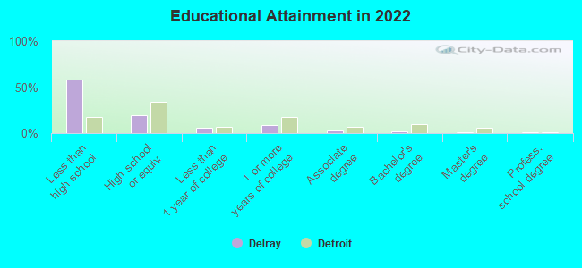
Education in this neighborhood (subdivision or community):
- Percentage of people 3 years and older in K-12 schools:
Delray: 42.9% Detroit: 18.0%
- Percentage of people 3 years and older in undergraduate colleges:
Delray: 3.9% Detroit: 3.8%
- Percentage of people 3 years and older in grad. or professional schools:
Delray: 0.1% Detroit: 1.0%
- Percentage of students K-12 enrolled in private schools:
Delray: 4.5% Detroit: 8.2%
Percentage of population below poverty level:
| Delray: | 24.3% |
| Detroit: | 33.8% |
Median year owner moved in (as recorded in 2022):
Median year renter moved in (as recorded in 2022):
| Delray: | 2005 |
| Detroit: | 2005 |
Median year renter moved in (as recorded in 2022):
| Delray: | 2015 |
| Detroit: | 2019 |
Percentage of married-couple families with both working:
| Delray: | 43.9% |
| Detroit: | 40.7% |

- 91.2%Utility gas
- 6.8%Electricity
- 1.3%No fuel used
- 0.7%Bottled, tank, or LP gas
Limited-access highways (interstate or state) in this neighborhood:
Fisher Fwy (I- 75)
Length: 1.43 miles
Direction: SW-NE
Direction: SW-NE
Roads and streets:
W Jefferson Ave
Length: 2.25 miles
Directions: E-W, SW-NE
Address range: 6100 to 9099
Directions: E-W, SW-NE
Address range: 6100 to 9099
W Fort St
Length: 2.09 miles
Directions: E-W, SW-NE
Address range: 6300 to 9399
Directions: E-W, SW-NE
Address range: 6300 to 9399
South St
Length: 1.65 miles
Directions: E-W, SW-NE
Address range: 6200 to 8901
Directions: E-W, SW-NE
Address range: 6200 to 8901
Melville St
Length: 1.35 miles
Directions: E-W, SW-NE
Address range: 7200 to 9299
Directions: E-W, SW-NE
Address range: 7200 to 9299
Dearborn St
Length: 1.08 miles
Directions: E-W, SE-NW
Address range: 8230 to 9413
Directions: E-W, SE-NW
Address range: 8230 to 9413
Thaddeus St
Length: 0.90 miles
Direction: E-W
Address range: 8000 to 9176
Direction: E-W
Address range: 8000 to 9176
S West End St
Length: 0.68 miles
Directions: E-W, N-S, SE-NW
Address range: 100 to 1199
Directions: E-W, N-S, SE-NW
Address range: 100 to 1199
Vanderbilt St
Length: 0.51 miles
Direction: E-W
Address range: 8000 to 8699
Direction: E-W
Address range: 8000 to 8699
S Green St
Length: 0.46 miles
Direction: SE-NW
Address range: 100 to 843
Direction: SE-NW
Address range: 100 to 843
Gould St
Length: 0.46 miles
Directions: E-W, SW-NE
Address range: 7100 to 7799
Directions: E-W, SW-NE
Address range: 7100 to 7799
S Post St
Length: 0.46 miles
Direction: SE-NW
Address range: 200 to 799
Direction: SE-NW
Address range: 200 to 799
S Waterman St
Length: 0.45 miles
Direction: SE-NW
Address range: 100 to 711
Direction: SE-NW
Address range: 100 to 711
S Rademacher St
Length: 0.44 miles
Direction: SE-NW
Address range: 100 to 733
Direction: SE-NW
Address range: 100 to 733
Copland St
Length: 0.41 miles
Direction: E-W
Direction: E-W
S Crawford St
Length: 0.40 miles
Direction: SE-NW
Address range: 100 to 751
Direction: SE-NW
Address range: 100 to 751
Harbaugh St
Length: 0.39 miles
Directions: N-S, SE-NW
Address range: 180 to 999
Directions: N-S, SE-NW
Address range: 180 to 999
Burdeno St
Length: 0.38 miles
Directions: E-W, SW-NE
Address range: 7900 to 8429
Directions: E-W, SW-NE
Address range: 7900 to 8429
S Solvay St
Length: 0.38 miles
Direction: SE-NW
Address range: 300 to 899
Direction: SE-NW
Address range: 300 to 899
S Harbaugh St
Length: 0.37 miles
Directions: N-S, SE-NW, SW-NE
Directions: N-S, SE-NW, SW-NE
S Harrington St
Length: 0.37 miles
Direction: SE-NW
Address range: 300 to 805
Direction: SE-NW
Address range: 300 to 805
S Reid St
Length: 0.35 miles
Direction: SE-NW
Address range: 200 to 769
Direction: SE-NW
Address range: 200 to 769
Keller St
Length: 0.35 miles
Direction: E-W
Address range: 8700 to 9176
Direction: E-W
Address range: 8700 to 9176
S Livernois Ave
Length: 0.34 miles
Direction: SE-NW
Address range: 100 to 683
Direction: SE-NW
Address range: 100 to 683
S Crossley St
Length: 0.33 miles
Direction: SE-NW
Address range: 400 to 851
Direction: SE-NW
Address range: 400 to 851
S Cottrell St
Length: 0.32 miles
Direction: SE-NW
Address range: 400 to 845
Direction: SE-NW
Address range: 400 to 845
Lyon St
Length: 0.31 miles
Directions: E-W, SW-NE
Address range: 9000 to 9299
Directions: E-W, SW-NE
Address range: 9000 to 9299
S Dragoon St
Length: 0.30 miles
Direction: SE-NW
Address range: 100 to 599
Direction: SE-NW
Address range: 100 to 599
S Military St
Length: 0.30 miles
Direction: SE-NW
Address range: 100 to 383
Direction: SE-NW
Address range: 100 to 383
Cary St
Length: 0.29 miles
Direction: SE-NW
Address range: 700 to 1139
Direction: SE-NW
Address range: 700 to 1139
Erie St
Length: 0.28 miles
Direction: E-W
Address range: 7200 to 7743
Direction: E-W
Address range: 7200 to 7743
Medina St
Length: 0.26 miles
Directions: E-W, SW-NE
Address range: 7800 to 8199
Directions: E-W, SW-NE
Address range: 7800 to 8199
Dill Pl
Length: 0.26 miles
Direction: E-W
Address range: 8026 to 8211
Direction: E-W
Address range: 8026 to 8211
S Schroeder St
Length: 0.26 miles
Direction: SE-NW
Address range: 500 to 741
Direction: SE-NW
Address range: 500 to 741
S Sloan St
Length: 0.25 miles
Direction: SE-NW
Address range: 600 to 999
Direction: SE-NW
Address range: 600 to 999
S Leigh St
Length: 0.24 miles
Direction: SE-NW
Address range: 200 to 799
Direction: SE-NW
Address range: 200 to 799
W End St
Length: 0.22 miles
Direction: SE-NW
Address range: 1 to 699
Direction: SE-NW
Address range: 1 to 699
American Way St
Length: 0.22 miles
Direction: SE-NW
Address range: 100 to 399
Direction: SE-NW
Address range: 100 to 399
Springwells St
Length: 0.21 miles
Direction: SE-NW
Address range: 500 to 699
Direction: SE-NW
Address range: 500 to 699
Clinton River Shore St
Length: 0.21 miles
Direction: SE-NW
Address range: 600 to 901
Direction: SE-NW
Address range: 600 to 901
Woodmere St
Length: 0.21 miles
Directions: N-S, SE-NW
Address range: 100 to 699
Directions: N-S, SE-NW
Address range: 100 to 699
Rademacher St
Length: 0.20 miles
Direction: SE-NW
Address range: 100 to 699
Direction: SE-NW
Address range: 100 to 699
Holly St
Length: 0.20 miles
Directions: E-W, N-S, SW-NE
Address range: 6300 to 6447
Directions: E-W, N-S, SW-NE
Address range: 6300 to 6447
Crawford St
Length: 0.20 miles
Direction: SE-NW
Address range: 100 to 699
Direction: SE-NW
Address range: 100 to 699
Waterman St
Length: 0.19 miles
Direction: SE-NW
Address range: 100 to 699
Direction: SE-NW
Address range: 100 to 699
Post St
Length: 0.19 miles
Direction: SE-NW
Address range: 100 to 199
Direction: SE-NW
Address range: 100 to 199
Green St
Length: 0.19 miles
Direction: SE-NW
Address range: 100 to 599
Direction: SE-NW
Address range: 100 to 599
S Sire St
Length: 0.19 miles
Directions: E-W, SW-NE
Address range: 8900 to 9201
Directions: E-W, SW-NE
Address range: 8900 to 9201
Hussar St
Length: 0.19 miles
Direction: E-W
Address range: 6100 to 6261
Direction: E-W
Address range: 6100 to 6261
Copland
Length: 0.18 miles
Directions: E-W, SW-NE
Directions: E-W, SW-NE
Harrington St
Length: 0.18 miles
Direction: SE-NW
Address range: 100 to 267
Direction: SE-NW
Address range: 100 to 267
Barnes St
Length: 0.15 miles
Direction: SW-NE
Address range: 7850 to 8057
Direction: SW-NE
Address range: 7850 to 8057
Reissman St
Length: 0.14 miles
Directions: E-W, SW-NE
Address range: 6400 to 6599
Directions: E-W, SW-NE
Address range: 6400 to 6599
Military St
Length: 0.14 miles
Direction: SE-NW
Address range: 100 to 467
Direction: SE-NW
Address range: 100 to 467
Hesse St
Length: 0.14 miles
Direction: E-W
Address range: 6400 to 6540
Direction: E-W
Address range: 6400 to 6540
Stone St
Length: 0.14 miles
Direction: E-W
Address range: 9180 to 9399
Direction: E-W
Address range: 9180 to 9399
Yale St
Length: 0.12 miles
Direction: SE-NW
Address range: 400 to 601
Direction: SE-NW
Address range: 400 to 601
Bacon St
Length: 0.12 miles
Direction: E-W
Address range: 7800 to 7899
Direction: E-W
Address range: 7800 to 7899
Livernois Ave
Length: 0.11 miles
Direction: SE-NW
Address range: 300 to 699
Direction: SE-NW
Address range: 300 to 699
Rankin St
Length: 0.10 miles
Directions: E-W, SW-NE
Address range: 6600 to 6699
Directions: E-W, SW-NE
Address range: 6600 to 6699
White St
Length: 0.10 miles
Directions: E-W, N-S, SE-NW, SW-NE
Address range: 8500 to 8699
Directions: E-W, N-S, SE-NW, SW-NE
Address range: 8500 to 8699
S Fortune St
Length: 0.10 miles
Direction: SE-NW
Address range: 200 to 299
Direction: SE-NW
Address range: 200 to 299
Anderson St
Length: 0.10 miles
Direction: SE-NW
Address range: 700 to 901
Direction: SE-NW
Address range: 700 to 901
S Cobalt St
Length: 0.10 miles
Direction: SE-NW
Address range: 200 to 285
Direction: SE-NW
Address range: 200 to 285
Dragoon St
Length: 0.09 miles
Direction: SE-NW
Address range: 100 to 299
Direction: SE-NW
Address range: 100 to 299
Voss St
Length: 0.09 miles
Direction: SE-NW
Direction: SE-NW
N Ave
Length: 0.09 miles
Direction: SE-NW
Address range: 232 to 299
Direction: SE-NW
Address range: 232 to 299
Buelow Ct
Length: 0.09 miles
Direction: E-W
Address range: 6300 to 6371
Direction: E-W
Address range: 6300 to 6371
S Edwin St
Length: 0.08 miles
Directions: E-W, N-S, SW-NE
Address range: 800 to 899
Directions: E-W, N-S, SW-NE
Address range: 800 to 899
Carbon St
Length: 0.07 miles
Direction: SW-NE
Address range: 9400 to 9498
Direction: SW-NE
Address range: 9400 to 9498
Green Pl
Length: 0.07 miles
Direction: E-W
Address range: 7100 to 7151
Direction: E-W
Address range: 7100 to 7151
Springwells Ave
Length: 0.06 miles
Direction: SE-NW
Address range: 800 to 849
Direction: SE-NW
Address range: 800 to 849
Edwin Dr S
Length: 0.05 miles
Directions: N-S, SE-NW
Directions: N-S, SE-NW
Anson St
Length: 0.02 miles
Directions: E-W, SE-NW
Address range: 800 to 861
Directions: E-W, SE-NW
Address range: 800 to 861
Railroad features:
Detroit Toledo and Ironton RR
Length: 12.40 miles
Directions: E-W, N-S, SE-NW, SW-NE
Directions: E-W, N-S, SE-NW, SW-NE
Wabash RR
Length: 7.74 miles
Directions: E-W, N-S, SE-NW, SW-NE
Directions: E-W, N-S, SE-NW, SW-NE
Penn Central RR
Length: 1.75 miles
Directions: E-W, N-S, SE-NW, SW-NE
Directions: E-W, N-S, SE-NW, SW-NE
Norfolk and Western RR
Length: 0.60 miles
Directions: E-W, N-S, SE-NW, SW-NE
Directions: E-W, N-S, SE-NW, SW-NE
Other features:
Rouge Riv
Length: 0.00 miles
Direction: E-W
Direction: E-W