Libby Road neighborhood in Maple Heights, Ohio (OH), 44137, 44146 detailed profile
Settings
X

Business Search - 14 Million verified businesses
Area: 3.588 square miles
Population: 22,786
Population density:
| Libby Road: | 6,350 people per square mile |
| Maple Heights: | 4,522 people per square mile |

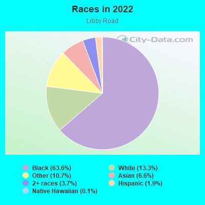
- 18,45263.6%Black
- 3,86313.3%White
- 3,11710.7%Some other race
- 1,9106.6%Asian
- 1,0793.7%Two or more races
- 5501.9%Hispanic or Latino
- 380.1%Native Hawaiian and Other
Pacific Islander
Distribution of median household income
![Distribution of median household income]()
- 891Less than $10,000
- 1,477$10,000 to $19,999
- 2,172$20,000 to $29,999
- 2,637$30,000 to $39,999
- 1,962$40,000 to $49,999
- 1,136$50,000 to $59,999
- 1,780$60,000 to $74,999
- 1,460$75,000 to $99,999
- 819$100,000 to $124,999
- 659$125,000 to $149,999
- 2,420$150,000 to $199,999
- 448$200,000 or more

Distribution of owner-occupied house/condo value
![Distribution of owner-occupied house/condo value]()
- 2,006Less than $50,000
- 7,247$50,000 to $99,999
- 1,574$100,000 to $149,999
- 1,103$150,000 to $199,999
- 189$200,000 to $249,999
- 56$250,000 to $299,999
- 137$300,000 to $399,999
- 62$400,000 to $499,999
- 154$500,000 to $749,999
- 543$750,000 to $999,999
- 157$1,000,000 or more

Distribution of rent paid by renters
![Distribution of rent paid by renters]()
- 82Less than $100
- 732$100 to $199
- 430$200 to $299
- 1,476$300 to $399
- 719$400 to $499
- 1,365$500 to $599
- 2,253$600 to $699
- 843$700 to $799
- 1,505$800 to $899
- 1,306$900 to $999
- 1,852$1,000 to $1,249
- 3,713$1,250 to $1,499
- 117$1,500 to $1,999
- 1,074$2,000 or more

| Males: | 10,243 |
| Females: | 12,542 |
Males:
| This neighborhood: | |
| Whole city: |
| This neighborhood: | 44.1 years |
| Whole city: | 44.6 years |
Average household size:
| Libby Road: | 5.6 people |
| Maple Heights: | 2.3 people |
Percentage of family households:
| Libby Road: | 40.8% |
| Maple Heights: | 41.1% |
| Here: | 30.4% |
| Maple Heights: | 25.5% |
Percentage of married-couple families with children (among all households):
| Libby Road: | 20.3% |
| Maple Heights: | 17.4% |
Percentage of single-mother households (among all households):
| Libby Road: | 40.2% |
| Maple Heights: | 20.8% |
Percentage of never married males 15 years old and over:
Percentage of never married females 15 years old and over:
| Libby Road: | 18.4% |
| Maple Heights: | 17.5% |
Percentage of never married females 15 years old and over:
| Libby Road: | 25.6% |
| city: | 25.7% |
Percentage of people that speak English not well or not at all:
| Libby Road: | 0.0% |
| Maple Heights: | 0.1% |
Percentage of people born in this state:
Percentage of people born in another U.S. state:
Percentage of native residents but born outside the U.S.:
Percentage of foreign born residents:
| Here: | 83.9% |
| Maple Heights: | 84.6% |
Percentage of people born in another U.S. state:
| Libby Road: | 14.1% |
| Maple Heights: | 13.2% |
Percentage of native residents but born outside the U.S.:
| Here: | 0.3% |
| city: | 0.5% |
Percentage of foreign born residents:
| Here: | 1.9% |
| Maple Heights: | 1.8% |
Owner-occupied
Renter-occupied

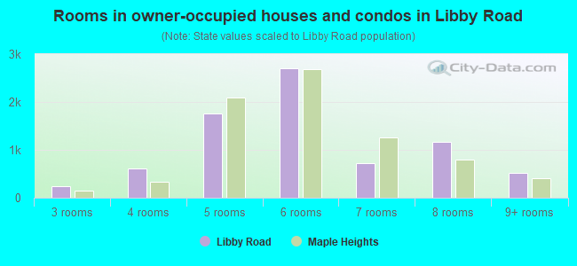
- Rooms in owner-occupied houses and condos in Libby Road
- 01 room
- 02 rooms
- 2443 rooms
- 6034 rooms
- 1,7535 rooms
- 2,7116 rooms
- 7287 rooms
- 1,1748 rooms
- 5239+ rooms
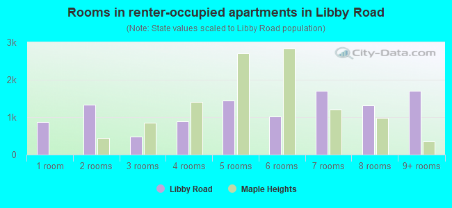
- Rooms in renter-occupied apartments in Libby Road
- 8791 room
- 1,3302 rooms
- 4903 rooms
- 8974 rooms
- 1,4505 rooms
- 1,0206 rooms
- 1,6957 rooms
- 1,3178 rooms
- 1,7099+ rooms
Owner-occupied
Renter-occupied
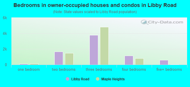
- Bedrooms in owner-occupied houses and condos in Libby Road
- 0no bedroom
- 1061 bedroom
- 1,6622 bedrooms
- 3,7683 bedrooms
- 1,1504 bedrooms
- 5895+ bedrooms
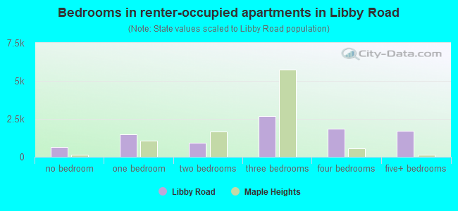
- Bedrooms in renter-occupied apartments in Libby Road
- 653no bedroom
- 1,4721 bedroom
- 9222 bedrooms
- 2,6953 bedrooms
- 1,8694 bedrooms
- 1,7095+ bedrooms
Average number of cars or other vehicles available in houses/condos:
Average number of cars or other vehicles available in apartments:
| This neighborhood: | 2.1 |
| Maple Heights: | 1.6 |
Average number of cars or other vehicles available in apartments:
| Here: | 1.6 |
| city: | 1.3 |
Percentage of units with a mortgage:
| Libby Road: | 64.6% |
| Maple Heights: | 61.4% |
Average estimated value of detached houses in 2022 (86.8% of all units):
| Libby Road: | $89,103 |
| Ohio: | $254,366 |
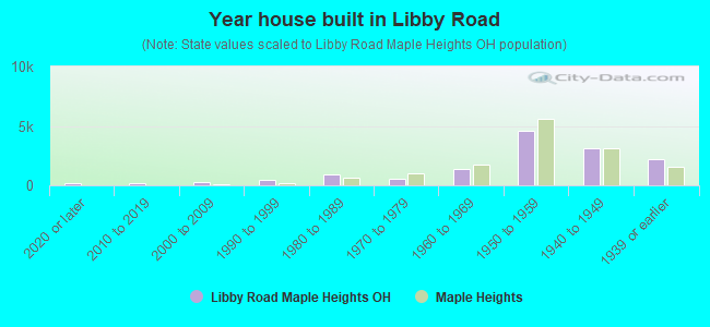
- Year house built in Libby Road
- 1542020 or later
- 1952010 to 2019
- 2452000 to 2009
- 4461990 to 1999
- 9431980 to 1989
- 5661970 to 1979
- 1,3961960 to 1969
- 4,6291950 to 1959
- 3,1211940 to 1949
- 2,2041939 or earlier
City-data.com crime index for city in 2020 (higher means more crime):
| City: | 204.5 |
| U.S. average: | 219.5 |
Travel time to work (commute)
![Travel time to work (commute)]()
- 242Less than 5 minutes
- 4475 to 9 minutes
- 77310 to 14 minutes
- 1,05915 to 19 minutes
- 2,46920 to 24 minutes
- 72125 to 29 minutes
- 91630 to 34 minutes
- 17335 to 39 minutes
- 47940 to 44 minutes
- 76145 to 59 minutes
- 28860 to 89 minutes
- 18890 or more minutes

Means of transportation to work
![Means of transportation to work]()
- 80.5%8,025Drove a car alone
- 14.9%1,487Carpooled
- 3.1%305Bus
- 0.3%28Subway or elevated rail
- 7.4%733Walked
- 2.1%212Other means
- 10.0%993Worked at home

Time leaving home to go to work
![Time leaving home to go to work]()
- 31812:00 a.m. to 4:59 a.m.
- 2015:00 a.m. to 5:29 a.m.
- 2345:30 a.m. to 5:59 a.m.
- 8066:00 a.m. to 6:29 a.m.
- 3866:30 a.m. to 6:59 a.m.
- 1,2327:00 a.m. to 7:29 a.m.
- 9157:30 a.m. to 7:59 a.m.
- 1,0728:00 a.m. to 8:29 a.m.
- 6288:30 a.m. to 8:59 a.m.
- 4009:00 a.m. to 9:59 a.m.
- 50410:00 a.m. to 10:59 a.m.
- 13511:00 a.m. to 11:59 a.m.
- 47412:00 p.m. to 3:59 p.m.
- 7524:00 p.m. to 11:59 p.m.

Occupations of males:
- Percentage of males in management occupations (except farmers):
Here: 11.5% city: 8.0%
- Percentage of males in business and financial operations occupations:
Here: 5.7% city: 5.4%
- Percentage of males in computer and mathematical occupations:
Here: 1.6% city: 2.3%
- Percentage of males in life, physical, and social science occupations:
Here: 2.2% city: 1.1%
- Percentage of males in education, training, and library occupations:
Here: 1.3% city: 2.6%
- Percentage of males in service occupations:
Here: 17.3% city: 16.7%
- Percentage of males in sales and office occupations:
Here: 18.7% city: 18.2%
- Percentage of males in construction, extraction, and maintenance occupations:
Here: 2.3% city: 4.8%
- Percentage of males in production occupations:
Here: 6.5% city: 9.7%
- Percentage of males in transportation occupations:
Here: 8.4% city: 10.2%
- Percentage of males in material moving occupations:
Here: 16.7% city: 13.0%
Occupations of females:
- Percentage of females in management occupations (except farmers):
Here: 1.5% city: 3.9%
- Percentage of females in business and financial operations occupations:
Here: 5.3% city: 9.2%
- Percentage of females in computer and mathematical occupations:
Here: 1.4% city: 1.1%
- Percentage of females in community and social services occupations:
Here: 2.8% city: 3.2%
- Percentage of females in education, training, and library occupations:
Here: 6.2% city: 6.2%
- Percentage of females in healthcare practitioners and technical occupations:
Here: 7.5% city: 8.2%
- Percentage of females in service occupations:
Here: 33.0% city: 23.2%
- Percentage of females in sales and office occupations:
Here: 30.5% city: 31.8%
- Percentage of females in production occupations:
Here: 6.8% city: 7.1%
- Percentage of females in transportation occupations:
Here: 2.2% city: 2.0%
Education in this neighborhood (subdivision or community):
- Percentage of people 3 years and older in K-12 schools:
Libby Road: 53.2% Maple Heights: 17.4%
- Percentage of people 3 years and older in undergraduate colleges:
Libby Road: 13.2% Maple Heights: 2.9%
- Percentage of people 3 years and older in grad. or professional schools:
Libby Road: 7.6% Maple Heights: 1.2%
- Percentage of students K-12 enrolled in private schools:
Libby Road: 62.5% Maple Heights: 26.7%
Percentage of population below poverty level:
| Libby Road: | 24.8% |
| Maple Heights: | 21.6% |
Percentage of married-couple families with both working:
| Libby Road: | 145.5% |
| Maple Heights: | 48.0% |
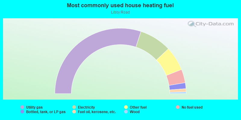
- 60.1%Utility gas
- 15.9%Electricity
- 12.0%Other fuel
- 6.7%No fuel used
- 2.9%Bottled, tank, or LP gas
- 1.6%Fuel oil, kerosene, etc.
- 0.8%Wood
Limited-access highways (interstate or state) in this neighborhood:
Outerbelt South Fwy (I- 480)
Length: 4.08 miles
Directions: E-W, SW-NE
Directions: E-W, SW-NE
Highways in this neighborhood:
State Rte 17 (Libby Rd)
Length: 3.08 miles
Direction: E-W
Address range: 15600 to 21799
Direction: E-W
Address range: 15600 to 21799
State Rte 14 (Broadway Ave)
Length: 1.89 miles
Direction: SE-NW
Address range: 14100 to 16998
Direction: SE-NW
Address range: 14100 to 16998
State Rte 17 (Granger Rd)
Length: 1.29 miles
Directions: E-W, SE-NW
Address range: 14000 to 15599
Directions: E-W, SE-NW
Address range: 14000 to 15599
State Rte 8 (Northfield Rd)
Length: 1.07 miles
Directions: N-S, SW-NE
Address range: 4932 to 5550
Directions: N-S, SW-NE
Address range: 4932 to 5550
Aurora Rd (State Rte 43)
Length: 0.05 miles
Directions: N-S, SE-NW
Address range: 21206 to 21699
Directions: N-S, SE-NW
Address range: 21206 to 21699
Roads and streets:
McCracken Rd
Length: 3.48 miles
Directions: E-W, SE-NW, SW-NE
Address range: 13357 to 21521
Directions: E-W, SE-NW, SW-NE
Address range: 13357 to 21521
Raymond St
Length: 3.19 miles
Direction: E-W
Address range: 15400 to 21649
Direction: E-W
Address range: 15400 to 21649
Maple Heights Blvd
Length: 2.59 miles
Directions: E-W, N-S, SW-NE
Address range: 15800 to 20219
Directions: E-W, N-S, SW-NE
Address range: 15800 to 20219
Gardenview Dr
Length: 1.25 miles
Directions: E-W, SE-NW
Address range: 19300 to 21615
Directions: E-W, SE-NW
Address range: 19300 to 21615
Greenhurst Dr
Length: 1.20 miles
Directions: E-W, N-S, SW-NE
Address range: 5027 to 5349
Directions: E-W, N-S, SW-NE
Address range: 5027 to 5349
Mapleboro Ave (Mapleboro Rd)
Length: 1.12 miles
Direction: E-W
Address range: 16800 to 18899
Direction: E-W
Address range: 16800 to 18899
Warrensville Center Rd
Length: 1.04 miles
Direction: N-S
Address range: 4932 to 5601
Direction: N-S
Address range: 4932 to 5601
Clement Ave (Clement St)
Length: 1.02 miles
Directions: N-S, SW-NE
Address range: 5022 to 5565
Directions: N-S, SW-NE
Address range: 5022 to 5565
Thomas St
Length: 0.96 miles
Direction: N-S
Address range: 5000 to 5598
Direction: N-S
Address range: 5000 to 5598
Clare Ave
Length: 0.91 miles
Direction: E-W
Address range: 19700 to 21713
Direction: E-W
Address range: 19700 to 21713
Lee Rd
Length: 0.89 miles
Directions: N-S, SW-NE
Address range: 4926 to 5451
Directions: N-S, SW-NE
Address range: 4926 to 5451
Dalewood Ave
Length: 0.87 miles
Directions: E-W, SW-NE
Address range: 5417 to 18499
Directions: E-W, SW-NE
Address range: 5417 to 18499
Preston Rd
Length: 0.72 miles
Directions: E-W, SE-NW
Address range: 17901 to 19711
Directions: E-W, SE-NW
Address range: 17901 to 19711
Southgate Park Blvd
Length: 0.72 miles
Directions: E-W, SE-NW, SW-NE
Address range: 20500 to 21699
Directions: E-W, SE-NW, SW-NE
Address range: 20500 to 21699
Watson Rd
Length: 0.69 miles
Directions: E-W, N-S
Address range: 20494 to 21649
Directions: E-W, N-S
Address range: 20494 to 21649
Franklin Rd
Length: 0.69 miles
Direction: E-W
Address range: 20500 to 21608
Direction: E-W
Address range: 20500 to 21608
Hillgrove Ave
Length: 0.69 miles
Direction: E-W
Address range: 20500 to 21615
Direction: E-W
Address range: 20500 to 21615
Applegate Rd
Length: 0.69 miles
Direction: E-W
Address range: 20500 to 21607
Direction: E-W
Address range: 20500 to 21607
Fairway Ave
Length: 0.69 miles
Directions: E-W, SE-NW
Address range: 18700 to 20021
Directions: E-W, SE-NW
Address range: 18700 to 20021
Donnybrook Rd
Length: 0.68 miles
Direction: E-W
Address range: 20590 to 20799
Direction: E-W
Address range: 20590 to 20799
Dunham Rd
Length: 0.67 miles
Directions: N-S, SE-NW, SW-NE
Address range: 5180 to 5520
Directions: N-S, SE-NW, SW-NE
Address range: 5180 to 5520
Watercrest Ave
Length: 0.66 miles
Directions: E-W, N-S
Address range: 19000 to 19199
Directions: E-W, N-S
Address range: 19000 to 19199
Mountville Dr
Length: 0.66 miles
Directions: E-W, SE-NW
Address range: 19600 to 20719
Directions: E-W, SE-NW
Address range: 19600 to 20719
Waterbury Ave
Length: 0.66 miles
Direction: E-W
Address range: 17701 to 18913
Direction: E-W
Address range: 17701 to 18913
Longview Ave
Length: 0.63 miles
Directions: E-W, SE-NW
Address range: 18700 to 19799
Directions: E-W, SE-NW
Address range: 18700 to 19799
Cato St
Length: 0.60 miles
Directions: N-S, SE-NW
Address range: 5020 to 5349
Directions: N-S, SE-NW
Address range: 5020 to 5349
Corridon Ave
Length: 0.60 miles
Direction: E-W
Address range: 14100 to 15105
Direction: E-W
Address range: 14100 to 15105
Hazelwood Ave
Length: 0.58 miles
Directions: E-W, SE-NW, SW-NE
Address range: 17700 to 18919
Directions: E-W, SE-NW, SW-NE
Address range: 17700 to 18919
Stockton Ave
Length: 0.58 miles
Direction: E-W
Address range: 19100 to 20299
Direction: E-W
Address range: 19100 to 20299
Hansen Rd
Length: 0.57 miles
Directions: E-W, SE-NW
Address range: 20500 to 21609
Directions: E-W, SE-NW
Address range: 20500 to 21609
Kenyon Dr
Length: 0.57 miles
Directions: E-W, SW-NE
Address range: 20600 to 21619
Directions: E-W, SW-NE
Address range: 20600 to 21619
Arch St
Length: 0.56 miles
Directions: N-S, SE-NW
Address range: 5020 to 5349
Directions: N-S, SE-NW
Address range: 5020 to 5349
E 141st St
Length: 0.55 miles
Direction: N-S
Address range: 5300 to 5527
Direction: N-S
Address range: 5300 to 5527
Camden Rd
Length: 0.54 miles
Direction: N-S
Address range: 4944 to 5299
Direction: N-S
Address range: 4944 to 5299
Nitra Ave
Length: 0.54 miles
Directions: E-W, SW-NE
Address range: 18500 to 19799
Directions: E-W, SW-NE
Address range: 18500 to 19799
Friend Ave
Length: 0.53 miles
Direction: E-W
Address range: 15500 to 16399
Direction: E-W
Address range: 15500 to 16399
Beechwood Ave
Length: 0.51 miles
Direction: N-S
Address range: 5300 to 5699
Direction: N-S
Address range: 5300 to 5699
South Blvd
Length: 0.50 miles
Directions: N-S, SW-NE
Address range: 5200 to 5551
Directions: N-S, SW-NE
Address range: 5200 to 5551
Anthony St
Length: 0.49 miles
Directions: E-W, N-S
Address range: 5100 to 16799
Directions: E-W, N-S
Address range: 5100 to 16799
Elmwood Ave
Length: 0.48 miles
Direction: N-S
Address range: 5300 to 5599
Direction: N-S
Address range: 5300 to 5599
Hollywood Ave
Length: 0.48 miles
Direction: N-S
Address range: 5300 to 5581
Direction: N-S
Address range: 5300 to 5581
Edinboro Ave
Length: 0.48 miles
Directions: E-W, N-S, SE-NW, SW-NE
Address range: 17700 to 18501
Directions: E-W, N-S, SE-NW, SW-NE
Address range: 17700 to 18501
Prayner Rd
Length: 0.47 miles
Direction: N-S
Address range: 4950 to 5299
Direction: N-S
Address range: 4950 to 5299
Erwin St
Length: 0.47 miles
Direction: N-S
Address range: 5021 to 5273
Direction: N-S
Address range: 5021 to 5273
Catherine St
Length: 0.47 miles
Direction: N-S
Address range: 5020 to 5226
Direction: N-S
Address range: 5020 to 5226
Joseph St
Length: 0.47 miles
Direction: N-S
Address range: 5020 to 5299
Direction: N-S
Address range: 5020 to 5299
Philip Ave (Philip St)
Length: 0.47 miles
Direction: N-S
Address range: 5000 to 5299
Direction: N-S
Address range: 5000 to 5299
Bowling Green Rd
Length: 0.46 miles
Directions: E-W, N-S, SE-NW, SW-NE
Address range: 20500 to 20799
Directions: E-W, N-S, SE-NW, SW-NE
Address range: 20500 to 20799
Maple Ave
Length: 0.46 miles
Directions: E-W, N-S, SE-NW, SW-NE
Address range: 14000 to 14499
Directions: E-W, N-S, SE-NW, SW-NE
Address range: 14000 to 14499
Mayville Ave
Length: 0.45 miles
Directions: N-S, SW-NE
Address range: 5200 to 5549
Directions: N-S, SW-NE
Address range: 5200 to 5549
Henry St
Length: 0.44 miles
Directions: E-W, N-S, SE-NW
Address range: 5191 to 5253
Directions: E-W, N-S, SE-NW
Address range: 5191 to 5253
Pease Rd
Length: 0.43 miles
Directions: E-W, SW-NE
Address range: 14000 to 14899
Directions: E-W, SW-NE
Address range: 14000 to 14899
Grasmere Ave
Length: 0.39 miles
Directions: N-S, SW-NE
Address range: 5400 to 5599
Directions: N-S, SW-NE
Address range: 5400 to 5599
Stanley Ave
Length: 0.39 miles
Directions: N-S, SW-NE
Address range: 5000 to 5299
Directions: N-S, SW-NE
Address range: 5000 to 5299
Sunnyslope Rd
Length: 0.37 miles
Directions: N-S, SE-NW
Address range: 5300 to 5579
Directions: N-S, SE-NW
Address range: 5300 to 5579
Clampher Rd
Length: 0.36 miles
Direction: N-S
Address range: 5000 to 5225
Direction: N-S
Address range: 5000 to 5225
Oakwood Ave
Length: 0.36 miles
Direction: N-S
Address range: 5300 to 5599
Direction: N-S
Address range: 5300 to 5599
Industrial Ave S
Length: 0.36 miles
Directions: E-W, N-S, SW-NE
Address range: 14100 to 14749
Directions: E-W, N-S, SW-NE
Address range: 14100 to 14749
Theodore St
Length: 0.33 miles
Direction: N-S
Address range: 5000 to 5299
Direction: N-S
Address range: 5000 to 5299
Miller Ave
Length: 0.33 miles
Directions: N-S, SW-NE
Address range: 5000 to 5299
Directions: N-S, SW-NE
Address range: 5000 to 5299
Industrial Ave N
Length: 0.33 miles
Directions: E-W, SE-NW
Address range: 14100 to 14699
Directions: E-W, SE-NW
Address range: 14100 to 14699
Stafford Ave
Length: 0.31 miles
Directions: E-W, SE-NW
Address range: 19100 to 19899
Directions: E-W, SE-NW
Address range: 19100 to 19899
E 139th St
Length: 0.31 miles
Directions: N-S, SE-NW
Address range: 5300 to 5798
Directions: N-S, SE-NW
Address range: 5300 to 5798
West Blvd
Length: 0.31 miles
Directions: E-W, SW-NE
Address range: 5353 to 5481
Directions: E-W, SW-NE
Address range: 5353 to 5481
Jackson Blvd
Length: 0.30 miles
Directions: N-S, SE-NW
Address range: 5450 to 17699
Directions: N-S, SE-NW
Address range: 5450 to 17699
Beverly Ave
Length: 0.30 miles
Direction: E-W
Address range: 19100 to 20075
Direction: E-W
Address range: 19100 to 20075
Harlan Dr
Length: 0.29 miles
Directions: E-W, N-S, SW-NE
Address range: 18600 to 18920
Directions: E-W, N-S, SW-NE
Address range: 18600 to 18920
Homewood Ave
Length: 0.28 miles
Direction: N-S
Address range: 5120 to 5272
Direction: N-S
Address range: 5120 to 5272
Industrial Ave
Length: 0.28 miles
Direction: E-W
Address range: 14600 to 15199
Direction: E-W
Address range: 14600 to 15199
Milan Dr
Length: 0.26 miles
Direction: E-W
Address range: 19250 to 19699
Direction: E-W
Address range: 19250 to 19699
Centuryway Rd
Length: 0.25 miles
Directions: E-W, N-S, SW-NE
Address range: 20600 to 20699
Directions: E-W, N-S, SW-NE
Address range: 20600 to 20699
Garden St
Length: 0.24 miles
Directions: N-S, SE-NW
Address range: 5490 to 5601
Directions: N-S, SE-NW
Address range: 5490 to 5601
Grant Ave
Length: 0.24 miles
Directions: E-W, SE-NW
Address range: 15700 to 16199
Directions: E-W, SE-NW
Address range: 15700 to 16199
Home Ave (Home St)
Length: 0.21 miles
Direction: E-W
Address range: 16200 to 16599
Direction: E-W
Address range: 16200 to 16599
North Blvd
Length: 0.21 miles
Directions: E-W, SW-NE
Address range: 17800 to 18115
Directions: E-W, SW-NE
Address range: 17800 to 18115
Lewis Dr
Length: 0.20 miles
Directions: E-W, SE-NW
Address range: 18200 to 18599
Directions: E-W, SE-NW
Address range: 18200 to 18599
Highland Dr
Length: 0.20 miles
Direction: E-W
Address range: 18100 to 18507
Direction: E-W
Address range: 18100 to 18507
Beech Ave
Length: 0.20 miles
Direction: N-S
Address range: 5186 to 5282
Direction: N-S
Address range: 5186 to 5282
Forest Ave
Length: 0.20 miles
Direction: N-S
Address range: 5180 to 5281
Direction: N-S
Address range: 5180 to 5281
Milo Ave
Length: 0.19 miles
Direction: N-S
Address range: 5184 to 5299
Direction: N-S
Address range: 5184 to 5299
Salisbury Rd
Length: 0.19 miles
Directions: E-W, SW-NE
Address range: 20450 to 21045
Directions: E-W, SW-NE
Address range: 20450 to 21045
Tatra Ave (Tatra St)
Length: 0.17 miles
Direction: N-S
Address range: 5000 to 5199
Direction: N-S
Address range: 5000 to 5199
Paine Ave
Length: 0.17 miles
Directions: N-S, SE-NW
Address range: 5200 to 5299
Directions: N-S, SE-NW
Address range: 5200 to 5299
Glenburn Ave
Length: 0.16 miles
Directions: E-W, SE-NW
Address range: 16000 to 16401
Directions: E-W, SE-NW
Address range: 16000 to 16401
Morgan St
Length: 0.16 miles
Direction: SW-NE
Address range: 5400 to 5559
Direction: SW-NE
Address range: 5400 to 5559
Meadow St
Length: 0.15 miles
Direction: SW-NE
Address range: 5100 to 5371
Direction: SW-NE
Address range: 5100 to 5371
Kohout St
Length: 0.15 miles
Direction: SW-NE
Address range: 5200 to 5351
Direction: SW-NE
Address range: 5200 to 5351
Knoll Dr (Knoll Ln)
Length: 0.15 miles
Directions: E-W, SE-NW
Address range: 18100 to 18399
Directions: E-W, SE-NW
Address range: 18100 to 18399
Charles St
Length: 0.15 miles
Directions: N-S, SE-NW
Address range: 5100 to 5199
Directions: N-S, SE-NW
Address range: 5100 to 5199
Hill St
Length: 0.14 miles
Direction: SW-NE
Address range: 5420 to 5481
Direction: SW-NE
Address range: 5420 to 5481
Holly Rd
Length: 0.14 miles
Direction: N-S
Address range: 5300 to 5499
Direction: N-S
Address range: 5300 to 5499
Lafayette Ave
Length: 0.13 miles
Direction: SW-NE
Address range: 5570 to 5623
Direction: SW-NE
Address range: 5570 to 5623
Orchard St
Length: 0.13 miles
Direction: SW-NE
Address range: 5391 to 5449
Direction: SW-NE
Address range: 5391 to 5449
Bellview St
Length: 0.13 miles
Direction: N-S
Address range: 5100 to 5299
Direction: N-S
Address range: 5100 to 5299
Earl Ave
Length: 0.12 miles
Direction: SE-NW
Address range: 5130 to 5187
Direction: SE-NW
Address range: 5130 to 5187
Marion St
Length: 0.12 miles
Direction: SW-NE
Address range: 5360 to 5449
Direction: SW-NE
Address range: 5360 to 5449
Auburn Ave
Length: 0.12 miles
Directions: N-S, SE-NW
Address range: 5300 to 5449
Directions: N-S, SE-NW
Address range: 5300 to 5449
Royal St
Length: 0.11 miles
Directions: N-S, SW-NE
Address range: 5300 to 5401
Directions: N-S, SW-NE
Address range: 5300 to 5401
Vine St
Length: 0.10 miles
Direction: N-S
Address range: 5300 to 5399
Direction: N-S
Address range: 5300 to 5399
Williams St
Length: 0.10 miles
Direction: E-W
Address range: 14500 to 14699
Direction: E-W
Address range: 14500 to 14699
Berkeley Ave
Length: 0.09 miles
Directions: E-W, SE-NW
Address range: 19100 to 19699
Directions: E-W, SE-NW
Address range: 19100 to 19699
Elm Dr (Elm St)
Length: 0.08 miles
Direction: E-W
Address range: 14300 to 14499
Direction: E-W
Address range: 14300 to 14499
Rex St
Length: 0.07 miles
Direction: N-S
Direction: N-S
Otis Pl
Length: 0.07 miles
Direction: SE-NW
Address range: 15700 to 15799
Direction: SE-NW
Address range: 15700 to 15799
Osborn Rd
Length: 0.07 miles
Directions: N-S, SE-NW
Address range: 5000 to 5049
Directions: N-S, SE-NW
Address range: 5000 to 5049
Portland Ave
Length: 0.06 miles
Direction: N-S
Address range: 5000 to 5049
Direction: N-S
Address range: 5000 to 5049
Evelyn Dr
Length: 0.06 miles
Directions: N-S, SE-NW, SW-NE
Address range: 5200 to 5299
Directions: N-S, SE-NW, SW-NE
Address range: 5200 to 5299
Williams St (Granger Ct)
Length: 0.06 miles
Direction: N-S
Address range: 5200 to 5299
Direction: N-S
Address range: 5200 to 5299
Roy Ave
Length: 0.06 miles
Direction: E-W
Address range: 21900 to 22099
Direction: E-W
Address range: 21900 to 22099
Sandalwood Rd
Length: 0.06 miles
Direction: E-W
Address range: 21900 to 22573
Direction: E-W
Address range: 21900 to 22573
Library Ln
Length: 0.05 miles
Direction: N-S
Address range: 5200 to 5299
Direction: N-S
Address range: 5200 to 5299
Bangor Ave
Length: 0.04 miles
Direction: E-W
Address range: 13900 to 13999
Direction: E-W
Address range: 13900 to 13999
Mapleboro Rd
Length: 0.03 miles
Direction: E-W
Direction: E-W
E 146th St
Length: 0.03 miles
Direction: N-S
Address range: 5200 to 5213
Direction: N-S
Address range: 5200 to 5213
Railroad features:
Norfolk and Western Rlwy
Length: 3.21 miles
Directions: E-W, SE-NW
Directions: E-W, SE-NW
Penn Central RR (Norfolk Southern Rlwy)
Length: 0.02 miles
Direction: SE-NW
Direction: SE-NW
Other features:
Mill Crk
Length: 2.00 miles
Directions: E-W, N-S, SE-NW, SW-NE
Directions: E-W, N-S, SE-NW, SW-NE