Lonsdale neighborhood in Knoxville, Tennessee (TN), 37912, 37917, 37921 detailed profile
Settings
X

Business Search - 14 Million verified businesses
Area: 2.844 square miles
Population: 7,298
Population density:
| Lonsdale: | 2,567 people per square mile |
| Knoxville: | 2,114 people per square mile |

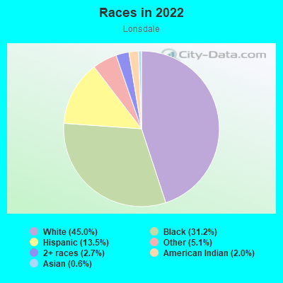
- 3,58745.0%White
- 2,48631.2%Black
- 1,07813.5%Hispanic or Latino
- 4065.1%Some other race
- 2122.7%Two or more races
- 1592.0%American Indian
- 450.6%Asian
Distribution of median household income
![Distribution of median household income]()
- 602Less than $10,000
- 432$10,000 to $19,999
- 564$20,000 to $29,999
- 519$30,000 to $39,999
- 497$40,000 to $49,999
- 120$50,000 to $59,999
- 540$60,000 to $74,999
- 197$75,000 to $99,999
- 247$100,000 to $124,999
- 307$125,000 to $149,999
- 106$150,000 to $199,999
- 843$200,000 or more

Distribution of owner-occupied house/condo value
![Distribution of owner-occupied house/condo value]()
- 1,184Less than $50,000
- 835$50,000 to $99,999
- 171$100,000 to $149,999
- 521$150,000 to $199,999
- 166$200,000 to $249,999
- 36$250,000 to $299,999
- 843$300,000 to $399,999
- 37$400,000 to $499,999
- 84$500,000 to $749,999
- 9$750,000 to $999,999
- 33$1,000,000 or more

Distribution of rent paid by renters
![Distribution of rent paid by renters]()
- 323Less than $100
- 585$100 to $199
- 683$200 to $299
- 396$300 to $399
- 794$400 to $499
- 266$500 to $599
- 200$600 to $699
- 745$700 to $799
- 527$800 to $899
- 281$900 to $999
- 325$1,000 to $1,249
- 87$1,250 to $1,499
- 63$1,500 to $1,999

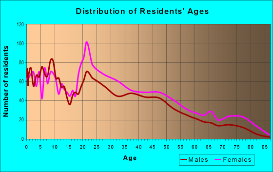
| Males: | 3,601 |
| Females: | 3,697 |
Males:
| This neighborhood: | 27.4 years |
| Whole city: | 31.5 years |
| This neighborhood: | 30.6 years |
| Whole city: | 33.5 years |
Average household size:
| Lonsdale: | 2.5 people |
| Knoxville: | 2.2 people |
Percentage of family households:
| Lonsdale: | 42.3% |
| Knoxville: | 36.0% |
| Here: | 24.9% |
| Knoxville: | 31.0% |
Percentage of married-couple families with children (among all households):
| Lonsdale: | 26.7% |
| Knoxville: | 23.7% |
Percentage of single-mother households (among all households):
| Lonsdale: | 24.3% |
| Knoxville: | 15.0% |
Percentage of never married males 15 years old and over:
Percentage of never married females 15 years old and over:
| Lonsdale: | 23.0% |
| Knoxville: | 23.7% |
Percentage of never married females 15 years old and over:
| Lonsdale: | 25.9% |
| city: | 24.2% |
Percentage of people that speak English not well or not at all:
| Lonsdale: | 4.9% |
| Knoxville: | 1.7% |
Percentage of people born in this state:
Percentage of people born in another U.S. state:
Percentage of native residents but born outside the U.S.:
Percentage of foreign born residents:
| Here: | 65.6% |
| Knoxville: | 61.7% |
Percentage of people born in another U.S. state:
| Lonsdale: | 21.7% |
| Knoxville: | 32.1% |
Percentage of native residents but born outside the U.S.:
| Here: | 3.3% |
| city: | 0.8% |
Percentage of foreign born residents:
| Here: | 9.4% |
| Knoxville: | 5.4% |
Owner-occupied
Renter-occupied

- Rooms in owner-occupied houses and condos in Lonsdale
- 01 room
- 02 rooms
- 673 rooms
- 3254 rooms
- 3845 rooms
- 1906 rooms
- 2507 rooms
- 218 rooms
- 7899+ rooms
- Rooms in renter-occupied apartments in Lonsdale
- 2811 room
- 1872 rooms
- 4253 rooms
- 8194 rooms
- 7225 rooms
- 2136 rooms
- 897 rooms
- 1028 rooms
- 09+ rooms
Owner-occupied
Renter-occupied
- Bedrooms in owner-occupied houses and condos in Lonsdale
- 0no bedroom
- 371 bedroom
- 3822 bedrooms
- 4993 bedrooms
- 2014 bedrooms
- 845+ bedrooms
- Bedrooms in renter-occupied apartments in Lonsdale
- 281no bedroom
- 3451 bedroom
- 1,2652 bedrooms
- 4923 bedrooms
- 684 bedrooms
- 05+ bedrooms
Average number of cars or other vehicles available in houses/condos:
Average number of cars or other vehicles available in apartments:
| This neighborhood: | |
| Knoxville: |
Average number of cars or other vehicles available in apartments:
| Here: | 1.2 |
| city: | 1.4 |
Percentage of units with a mortgage:
| Lonsdale: | 58.9% |
| Knoxville: | 58.0% |
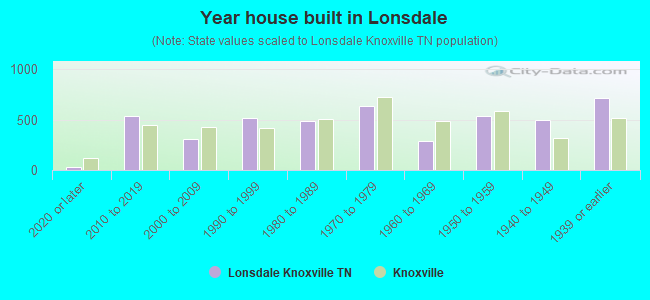
- Year house built in Lonsdale
- 322020 or later
- 5372010 to 2019
- 3112000 to 2009
- 5181990 to 1999
- 4831980 to 1989
- 6361970 to 1979
- 2891960 to 1969
- 5341950 to 1959
- 4961940 to 1949
- 7201939 or earlier
City-data.com crime index for city in 2020 (higher means more crime):
| City: | 460.5 |
| U.S. average: | 219.5 |
Travel time to work (commute)
![Travel time to work (commute)]()
- 125Less than 5 minutes
- 6035 to 9 minutes
- 76010 to 14 minutes
- 95815 to 19 minutes
- 55820 to 24 minutes
- 33725 to 29 minutes
- 53830 to 34 minutes
- 10235 to 39 minutes
- 7840 to 44 minutes
- 15845 to 59 minutes
- 2060 to 89 minutes
- 13190 or more minutes

Means of transportation to work
![Means of transportation to work]()
- 68.3%2,251Drove a car alone
- 21.9%721Carpooled
- 2.2%74Bus
- 29.4%970Taxi
- 0.7%24Bicycle
- 7.9%261Walked
- 2.3%77Other means
- 7.7%253Worked at home

Time leaving home to go to work
![Time leaving home to go to work]()
- 33912:00 a.m. to 4:59 a.m.
- 665:00 a.m. to 5:29 a.m.
- 475:30 a.m. to 5:59 a.m.
- 1286:00 a.m. to 6:29 a.m.
- 6016:30 a.m. to 6:59 a.m.
- 5937:00 a.m. to 7:29 a.m.
- 5097:30 a.m. to 7:59 a.m.
- 3668:00 a.m. to 8:29 a.m.
- 2228:30 a.m. to 8:59 a.m.
- 2499:00 a.m. to 9:59 a.m.
- 13410:00 a.m. to 10:59 a.m.
- 18111:00 a.m. to 11:59 a.m.
- 59412:00 p.m. to 3:59 p.m.
- 3914:00 p.m. to 11:59 p.m.

Occupations of males:
- Percentage of males in management occupations (except farmers):
Here: 14.0% city: 8.8%
- Percentage of males in business and financial operations occupations:
Here: 2.4% city: 4.3%
- Percentage of males in computer and mathematical occupations:
Here: 3.2% city: 4.0%
- Percentage of males in architecture and engineering occupations:
Here: 1.7% city: 3.4%
- Percentage of males in education, training, and library occupations:
Here: 3.2% city: 4.8%
- Percentage of males in healthcare practitioners and technical occupations:
Here: 1.1% city: 3.1%
- Percentage of males in service occupations:
Here: 11.2% city: 18.1%
- Percentage of males in sales and office occupations:
Here: 9.7% city: 15.7%
- Percentage of males in construction, extraction, and maintenance occupations:
Here: 22.6% city: 9.2%
- Percentage of males in production occupations:
Here: 13.4% city: 6.0%
- Percentage of males in transportation occupations:
Here: 6.4% city: 5.6%
- Percentage of males in material moving occupations:
Here: 4.2% city: 5.5%
Occupations of females:
- Percentage of females in management occupations (except farmers):
Here: 6.5% city: 8.6%
- Percentage of females in business and financial operations occupations:
Here: 2.1% city: 5.2%
- Percentage of females in computer and mathematical occupations:
Here: 1.7% city: 1.7%
- Percentage of females in community and social services occupations:
Here: 5.6% city: 2.8%
- Percentage of females in education, training, and library occupations:
Here: 6.4% city: 8.3%
- Percentage of females in arts, design, entertainment, sports, and media occupations:
Here: 5.0% city: 3.0%
- Percentage of females in healthcare practitioners and technical occupations:
Here: 5.9% city: 9.6%
- Percentage of females in service occupations:
Here: 27.9% city: 21.9%
- Percentage of females in sales and office occupations:
Here: 27.6% city: 28.0%
- Percentage of females in production occupations:
Here: 6.4% city: 3.4%
- Percentage of females in transportation occupations:
Here: 1.1% city: 1.3%
- Percentage of females in material moving occupations:
Here: 2.5% city: 2.4%
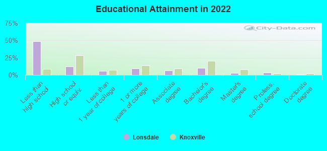
Education in this neighborhood (subdivision or community):
- Percentage of people 3 years and older in K-12 schools:
Lonsdale: 56.0% Knoxville: 12.6%
- Percentage of people 3 years and older in undergraduate colleges:
Lonsdale: 20.5% Knoxville: 12.8%
- Percentage of people 3 years and older in grad. or professional schools:
Lonsdale: 2.9% Knoxville: 3.0%
- Percentage of students K-12 enrolled in private schools:
Lonsdale: 44.7% Knoxville: 9.2%
Percentage of population below poverty level:
| Lonsdale: | 24.8% |
| Knoxville: | 17.5% |
Percentage of married-couple families with both working:
| Lonsdale: | 87.6% |
| Knoxville: | 66.2% |
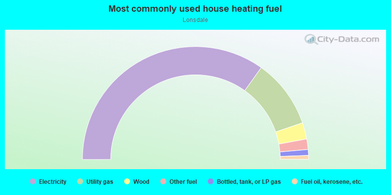
- 69.7%Electricity
- 19.7%Utility gas
- 4.7%Wood
- 3.0%Other fuel
- 1.7%Bottled, tank, or LP gas
- 1.1%Fuel oil, kerosene, etc.
Limited-access highways (interstate or state) in this neighborhood:
I- 275
Length: 2.44 miles
Directions: E-W, N-S, SE-NW, SW-NE
Directions: E-W, N-S, SE-NW, SW-NE
I- 75 (I- 640)
Length: 1.28 miles
Direction: SW-NE
Direction: SW-NE
Highways in this neighborhood:
State Hwy 62 (Western Ave, Western Ave NW)
Length: 1.38 miles
Directions: E-W, N-S, SE-NW
Address range: 2300 to 4099
Directions: E-W, N-S, SE-NW
Address range: 2300 to 4099
State Hwy 9 (US Hwy 25W)
Length: 0.33 miles
Directions: E-W, SE-NW, SW-NE
Directions: E-W, SE-NW, SW-NE
US Hwy 25W (Clinton Hwy, State Hwy 9)
Length: 0.03 miles
Directions: E-W, SE-NW
Directions: E-W, SE-NW
Roads and streets:
Texas Ave NW (Texas Ave)
Length: 1.45 miles
Directions: N-S, SW-NE
Address range: 700 to 2899
Directions: N-S, SW-NE
Address range: 700 to 2899
Virginia Ave (Virginia Ave NW)
Length: 1.34 miles
Direction: SW-NE
Address range: 700 to 2299
Direction: SW-NE
Address range: 700 to 2299
Vermont Ave (Vermont Ave NW)
Length: 1.23 miles
Directions: N-S, SW-NE
Address range: 726 to 2299
Directions: N-S, SW-NE
Address range: 726 to 2299
Maryland Ave (Maryland Ave NW)
Length: 1.07 miles
Directions: N-S, SW-NE
Address range: 900 to 2199
Directions: N-S, SW-NE
Address range: 900 to 2199
Ohio Ave NW (Ohio Ave)
Length: 1.07 miles
Directions: N-S, SW-NE
Address range: 700 to 2199
Directions: N-S, SW-NE
Address range: 700 to 2199
Tennessee Ave NW
Length: 1.04 miles
Direction: SW-NE
Address range: 900 to 2317
Direction: SW-NE
Address range: 900 to 2317
Beaumont Ave
Length: 1.01 miles
Direction: E-W
Address range: 800 to 1935
Direction: E-W
Address range: 800 to 1935
Burnside St
Length: 0.95 miles
Directions: E-W, N-S, SE-NW, SW-NE
Address range: 2300 to 3399
Directions: E-W, N-S, SE-NW, SW-NE
Address range: 2300 to 3399
Massachusetts Ave NW (Massachusetts Ave)
Length: 0.94 miles
Directions: E-W, N-S, SW-NE
Address range: 900 to 2299
Directions: E-W, N-S, SW-NE
Address range: 900 to 2299
Johnston St (Johnston St NW)
Length: 0.94 miles
Directions: N-S, SE-NW
Address range: 2300 to 3399
Directions: N-S, SE-NW
Address range: 2300 to 3399
I275 (I275 N in)
Length: 0.91 miles
Directions: E-W, SE-NW
Directions: E-W, SE-NW
Gap Rd
Length: 0.88 miles
Directions: N-S, SE-NW, SW-NE
Address range: 3300 to 4104
Directions: N-S, SE-NW, SW-NE
Address range: 3300 to 4104
W Oldham Ave
Length: 0.85 miles
Directions: E-W, N-S, SE-NW, SW-NE
Address range: 578 to 1607
Directions: E-W, N-S, SE-NW, SW-NE
Address range: 578 to 1607
Louisiana Ave (Louisiana Ave NW)
Length: 0.79 miles
Directions: E-W, SW-NE
Address range: 1000 to 1999
Directions: E-W, SW-NE
Address range: 1000 to 1999
Connecticut Ave (Connecticut Ave NW)
Length: 0.78 miles
Direction: SW-NE
Address range: 1000 to 1999
Direction: SW-NE
Address range: 1000 to 1999
I640 / I75 (I640, I640 E in)
Length: 0.78 miles
Direction: SW-NE
Direction: SW-NE
Jourolman Ave
Length: 0.78 miles
Directions: E-W, N-S, SE-NW, SW-NE
Address range: 1200 to 1999
Directions: E-W, N-S, SE-NW, SW-NE
Address range: 1200 to 1999
Pleasant Ridge Rd
Length: 0.78 miles
Directions: N-S, SE-NW, SW-NE
Address range: 3100 to 4183
Directions: N-S, SE-NW, SW-NE
Address range: 3100 to 4183
Delaware Ave NW (Delaware Ave)
Length: 0.78 miles
Direction: SW-NE
Address range: 900 to 1799
Direction: SW-NE
Address range: 900 to 1799
Stonewall St (Stonewall St NW)
Length: 0.73 miles
Directions: E-W, N-S, SE-NW
Address range: 2300 to 3199
Directions: E-W, N-S, SE-NW
Address range: 2300 to 3199
Ambrose St
Length: 0.73 miles
Directions: E-W, SE-NW, SW-NE
Address range: 200 to 3499
Directions: E-W, SE-NW, SW-NE
Address range: 200 to 3499
Sycamore Dr
Length: 0.67 miles
Directions: E-W, SW-NE
Address range: 2100 to 2499
Directions: E-W, SW-NE
Address range: 2100 to 2499
Heiskell Ave
Length: 0.64 miles
Directions: E-W, SW-NE
Address range: 800 to 1299
Directions: E-W, SW-NE
Address range: 800 to 1299
Elm St NW (Elm St)
Length: 0.62 miles
Directions: E-W, N-S, SE-NW, SW-NE
Address range: 1100 to 1899
Directions: E-W, N-S, SE-NW, SW-NE
Address range: 1100 to 1899
Arizona Way (Minnesota Ave)
Length: 0.61 miles
Directions: E-W, N-S, SW-NE
Address range: 601 to 1299
Directions: E-W, N-S, SW-NE
Address range: 601 to 1299
Minnesota Ave NW
Length: 0.61 miles
Directions: N-S, SE-NW, SW-NE
Address range: 1300 to 2199
Directions: N-S, SE-NW, SW-NE
Address range: 1300 to 2199
Wilson Rd
Length: 0.59 miles
Directions: N-S, SW-NE
Address range: 2000 to 2399
Directions: N-S, SW-NE
Address range: 2000 to 2399
Schofield St
Length: 0.58 miles
Directions: N-S, SE-NW
Address range: 1900 to 2608
Directions: N-S, SE-NW
Address range: 1900 to 2608
Murphy Ave
Length: 0.56 miles
Directions: E-W, SE-NW
Address range: 700 to 999
Directions: E-W, SE-NW
Address range: 700 to 999
Bragg St NW
Length: 0.56 miles
Directions: E-W, SE-NW
Address range: 2300 to 3099
Directions: E-W, SE-NW
Address range: 2300 to 3099
W Scott Ave
Length: 0.50 miles
Directions: E-W, SW-NE
Address range: 700 to 1299
Directions: E-W, SW-NE
Address range: 700 to 1299
McPherson St
Length: 0.48 miles
Direction: SE-NW
Address range: 2600 to 3499
Direction: SE-NW
Address range: 2600 to 3499
Sunrise St NW (Sunrise St)
Length: 0.48 miles
Direction: SE-NW
Address range: 1200 to 1799
Direction: SE-NW
Address range: 1200 to 1799
McSpadden St
Length: 0.47 miles
Directions: N-S, SE-NW
Address range: 1300 to 1899
Directions: N-S, SE-NW
Address range: 1300 to 1899
Sherman St NW (Sherman St)
Length: 0.47 miles
Direction: SE-NW
Address range: 2600 to 3299
Direction: SE-NW
Address range: 2600 to 3299
Lonsdale Pike
Length: 0.45 miles
Directions: E-W, N-S, SE-NW, SW-NE
Address range: 1820 to 2299
Directions: E-W, N-S, SE-NW, SW-NE
Address range: 1820 to 2299
New York Ave (New York Ave NW)
Length: 0.44 miles
Direction: SW-NE
Address range: 1000 to 1599
Direction: SW-NE
Address range: 1000 to 1599
Divide St NW (Divide St)
Length: 0.42 miles
Directions: E-W, N-S, SE-NW, SW-NE
Address range: 3200 to 3599
Directions: E-W, N-S, SE-NW, SW-NE
Address range: 3200 to 3599
Cassell Dr NW
Length: 0.41 miles
Directions: E-W, N-S, SE-NW, SW-NE
Address range: 1200 to 1422
Directions: E-W, N-S, SE-NW, SW-NE
Address range: 1200 to 1422
Sanderson Rd (Sanderson Rd NW)
Length: 0.41 miles
Directions: E-W, N-S, SW-NE
Address range: 2900 to 3299
Directions: E-W, N-S, SW-NE
Address range: 2900 to 3299
Dakota Ave (Dakota Ave NW)
Length: 0.41 miles
Directions: N-S, SW-NE
Address range: 800 to 1299
Directions: N-S, SW-NE
Address range: 800 to 1299
Bonnyman Dr NW
Length: 0.39 miles
Directions: E-W, SE-NW, SW-NE
Address range: 1100 to 1512
Directions: E-W, SE-NW, SW-NE
Address range: 1100 to 1512
I640 (I640 E in)
Length: 0.39 miles
Direction: SW-NE
Direction: SW-NE
W Oak Hill Ave
Length: 0.38 miles
Direction: SW-NE
Address range: 700 to 999
Direction: SW-NE
Address range: 700 to 999
Winfrey St
Length: 0.37 miles
Direction: E-W
Address range: 2900 to 3399
Direction: E-W
Address range: 2900 to 3399
Jenkins St (Jenkins St NW)
Length: 0.35 miles
Direction: E-W
Address range: 3000 to 3399
Direction: E-W
Address range: 3000 to 3399
Keith Ave
Length: 0.35 miles
Direction: SW-NE
Address range: 1900 to 2399
Direction: SW-NE
Address range: 1900 to 2399
Larch St (Larch Ave)
Length: 0.35 miles
Directions: E-W, SW-NE
Address range: 1600 to 1699
Directions: E-W, SW-NE
Address range: 1600 to 1699
Reed St (Reed St NW)
Length: 0.34 miles
Directions: E-W, N-S, SE-NW
Address range: 1100 to 1899
Directions: E-W, N-S, SE-NW
Address range: 1100 to 1899
W Emerald Ave NW
Length: 0.34 miles
Directions: E-W, SW-NE
Address range: 700 to 999
Directions: E-W, SW-NE
Address range: 700 to 999
Bowling Ave (Bowling Ave NW)
Length: 0.33 miles
Directions: E-W, SE-NW
Address range: 1900 to 2199
Directions: E-W, SE-NW
Address range: 1900 to 2199
O Neal St NW (Oneal St)
Length: 0.32 miles
Directions: E-W, SE-NW, SW-NE
Address range: 3000 to 3399
Directions: E-W, SE-NW, SW-NE
Address range: 3000 to 3399
Birchwood Rd NW
Length: 0.32 miles
Directions: E-W, N-S, SE-NW, SW-NE
Address range: 3000 to 3217
Directions: E-W, N-S, SE-NW, SW-NE
Address range: 3000 to 3217
Gerald Dr
Length: 0.32 miles
Directions: E-W, N-S, SE-NW, SW-NE
Directions: E-W, N-S, SE-NW, SW-NE
Belleaire Ave
Length: 0.32 miles
Direction: SW-NE
Address range: 700 to 999
Direction: SW-NE
Address range: 700 to 999
Elderwood Rd NW
Length: 0.31 miles
Directions: E-W, SE-NW, SW-NE
Address range: 3901 to 4099
Directions: E-W, SE-NW, SW-NE
Address range: 3901 to 4099
Applewood Dr NW
Length: 0.31 miles
Directions: E-W, N-S, SE-NW
Address range: 3900 to 4099
Directions: E-W, N-S, SE-NW
Address range: 3900 to 4099
E Industrial Pkwy
Length: 0.29 miles
Directions: E-W, N-S, SE-NW, SW-NE
Address range: 3000 to 3099
Directions: E-W, N-S, SE-NW, SW-NE
Address range: 3000 to 3099
Iowa Ave
Length: 0.29 miles
Direction: SW-NE
Address range: 1300 to 1599
Direction: SW-NE
Address range: 1300 to 1599
Badgett Dr NW
Length: 0.29 miles
Directions: E-W, SE-NW
Address range: 2800 to 2999
Directions: E-W, SE-NW
Address range: 2800 to 2999
Thomas St (Thomas St NW)
Length: 0.28 miles
Direction: SE-NW
Address range: 3100 to 3499
Direction: SE-NW
Address range: 3100 to 3499
Galbraith St (Galbraith St NW)
Length: 0.28 miles
Direction: SE-NW
Address range: 2900 to 3299
Direction: SE-NW
Address range: 2900 to 3299
Orangewood Rd NW
Length: 0.26 miles
Directions: E-W, N-S, SW-NE
Address range: 3700 to 3899
Directions: E-W, N-S, SW-NE
Address range: 3700 to 3899
Katherine Ave
Length: 0.26 miles
Direction: SW-NE
Address range: 916 to 2916
Direction: SW-NE
Address range: 916 to 2916
Cherrywood Rd NW
Length: 0.26 miles
Direction: N-S
Address range: 3000 to 3199
Direction: N-S
Address range: 3000 to 3199
Pascal Dr NW (Pascal Dr)
Length: 0.25 miles
Directions: E-W, SE-NW, SW-NE
Address range: 1900 to 2099
Directions: E-W, SE-NW, SW-NE
Address range: 1900 to 2099
Gallaher St
Length: 0.25 miles
Direction: E-W
Address range: 1100 to 1399
Direction: E-W
Address range: 1100 to 1399
Fort Promise Dr
Length: 0.25 miles
Directions: E-W, N-S, SE-NW, SW-NE
Address range: 100 to 1599
Directions: E-W, N-S, SE-NW, SW-NE
Address range: 100 to 1599
Warner Dr NW
Length: 0.25 miles
Directions: E-W, N-S, SW-NE
Address range: 3600 to 3799
Directions: E-W, N-S, SW-NE
Address range: 3600 to 3799
W Woodland Ave
Length: 0.25 miles
Directions: E-W, SW-NE
Address range: 700 to 999
Directions: E-W, SW-NE
Address range: 700 to 999
W Industrial Pkwy
Length: 0.25 miles
Directions: E-W, SE-NW
Address range: 3000 to 3099
Directions: E-W, SE-NW
Address range: 3000 to 3099
Lantana Ln NW
Length: 0.24 miles
Directions: N-S, SE-NW, SW-NE
Address range: 1400 to 1499
Directions: N-S, SE-NW, SW-NE
Address range: 1400 to 1499
Rudy St (Rudy St NW)
Length: 0.24 miles
Directions: N-S, SE-NW
Address range: 3200 to 3399
Directions: N-S, SE-NW
Address range: 3200 to 3399
Sidebrook Ave
Length: 0.23 miles
Directions: N-S, SW-NE
Address range: 700 to 999
Directions: N-S, SW-NE
Address range: 700 to 999
Sheridan St NW (Sheridan St)
Length: 0.22 miles
Directions: N-S, SE-NW, SW-NE
Address range: 2700 to 2999
Directions: N-S, SE-NW, SW-NE
Address range: 2700 to 2999
Adcock Ave (Adcock Ave NW)
Length: 0.22 miles
Direction: N-S
Address range: 1100 to 1299
Direction: N-S
Address range: 1100 to 1299
Marion St NW
Length: 0.21 miles
Directions: N-S, SE-NW, SW-NE
Address range: 1700 to 1899
Directions: N-S, SE-NW, SW-NE
Address range: 1700 to 1899
Rector St NW (Rector St)
Length: 0.21 miles
Directions: E-W, SE-NW
Address range: 2900 to 3199
Directions: E-W, SE-NW
Address range: 2900 to 3199
Drive One NW (Alliance Dr)
Length: 0.21 miles
Directions: E-W, N-S, SE-NW, SW-NE
Address range: 100 to 1399
Directions: E-W, N-S, SE-NW, SW-NE
Address range: 100 to 1399
Myrtlewood Dr NW
Length: 0.20 miles
Directions: E-W, N-S, SW-NE
Address range: 3100 to 4015
Directions: E-W, N-S, SW-NE
Address range: 3100 to 4015
Bishop St (Bishop St NW)
Length: 0.20 miles
Directions: N-S, SE-NW
Address range: 3300 to 3499
Directions: N-S, SE-NW
Address range: 3300 to 3499
Mynderse Ave NW
Length: 0.19 miles
Direction: N-S
Address range: 2500 to 2799
Direction: N-S
Address range: 2500 to 2799
Stair Ave NW
Length: 0.19 miles
Directions: E-W, SW-NE
Address range: 1300 to 1499
Directions: E-W, SW-NE
Address range: 1300 to 1499
Rhode Island Rd
Length: 0.19 miles
Direction: SW-NE
Address range: 1401 to 1499
Direction: SW-NE
Address range: 1401 to 1499
Savoy St (Savoy St NW)
Length: 0.19 miles
Direction: SE-NW
Address range: 3300 to 3499
Direction: SE-NW
Address range: 3300 to 3499
Better Tomorrow Dr (Drive Three NW)
Length: 0.18 miles
Directions: E-W, SE-NW, SW-NE
Address range: 146 to 1299
Directions: E-W, SE-NW, SW-NE
Address range: 146 to 1299
Apricot Ave
Length: 0.18 miles
Direction: SW-NE
Address range: 1900 to 1999
Direction: SW-NE
Address range: 1900 to 1999
Midway St (Midway St NW)
Length: 0.18 miles
Direction: N-S
Address range: 3300 to 3399
Direction: N-S
Address range: 3300 to 3399
Hawkins St NW
Length: 0.18 miles
Directions: E-W, N-S, SE-NW
Address range: 2200 to 2399
Directions: E-W, N-S, SE-NW
Address range: 2200 to 2399
Grit St NW
Length: 0.18 miles
Directions: SE-NW, SW-NE
Address range: 3600 to 3699
Directions: SE-NW, SW-NE
Address range: 3600 to 3699
Montgomery Ave NW
Length: 0.17 miles
Direction: E-W
Address range: 3500 to 3799
Direction: E-W
Address range: 3500 to 3799
Dinwiddie St (Dinwiddie St NW)
Length: 0.16 miles
Directions: E-W, N-S
Address range: 900 to 1033
Directions: E-W, N-S
Address range: 900 to 1033
W Baxter Ave
Length: 0.16 miles
Directions: N-S, SE-NW, SW-NE
Address range: 686 to 906
Directions: N-S, SE-NW, SW-NE
Address range: 686 to 906
Bonny Ave NW (Bonny Ave)
Length: 0.15 miles
Direction: SW-NE
Address range: 1600 to 1717
Direction: SW-NE
Address range: 1600 to 1717
W Anderson Ave
Length: 0.15 miles
Directions: SE-NW, SW-NE
Address range: 700 to 899
Directions: SE-NW, SW-NE
Address range: 700 to 899
Industrial Pkwy
Length: 0.15 miles
Directions: N-S, SE-NW
Address range: 2900 to 2999
Directions: N-S, SE-NW
Address range: 2900 to 2999
Ely Ave NW
Length: 0.13 miles
Direction: SW-NE
Address range: 1501 to 1545
Direction: SW-NE
Address range: 1501 to 1545
Steel St
Length: 0.12 miles
Direction: SE-NW
Address range: 3600 to 3799
Direction: SE-NW
Address range: 3600 to 3799
New York Ave NW
Length: 0.12 miles
Direction: SW-NE
Address range: 1900 to 1999
Direction: SW-NE
Address range: 1900 to 1999
Testerman Dr NW
Length: 0.11 miles
Direction: E-W
Address range: 2000 to 2099
Direction: E-W
Address range: 2000 to 2099
Dereck Dr
Length: 0.11 miles
Directions: E-W, N-S, SE-NW
Address range: 2500 to 2599
Directions: E-W, N-S, SE-NW
Address range: 2500 to 2599
Evans St (Evans St NW)
Length: 0.11 miles
Direction: SE-NW
Address range: 200 to 398
Direction: SE-NW
Address range: 200 to 398
McClellan St
Length: 0.10 miles
Direction: N-S
Address range: 2200 to 2299
Direction: N-S
Address range: 2200 to 2299
Gordon St
Length: 0.10 miles
Direction: N-S
Address range: 2200 to 2299
Direction: N-S
Address range: 2200 to 2299
Gamecock Ave NW
Length: 0.09 miles
Direction: SW-NE
Address range: 1600 to 1699
Direction: SW-NE
Address range: 1600 to 1699
Hawkins St
Length: 0.09 miles
Direction: E-W
Direction: E-W
Goins Dr
Length: 0.09 miles
Directions: N-S, SE-NW, SW-NE
Address range: 1900 to 1999
Directions: N-S, SE-NW, SW-NE
Address range: 1900 to 1999
Sheridan St NW
Length: 0.08 miles
Directions: E-W, SE-NW, SW-NE
Address range: 2400 to 2499
Directions: E-W, SE-NW, SW-NE
Address range: 2400 to 2499
Crozier Ave (Crozier Ave NW)
Length: 0.08 miles
Directions: E-W, SW-NE
Address range: 1000 to 1099
Directions: E-W, SW-NE
Address range: 1000 to 1099
Dwight St
Length: 0.08 miles
Direction: E-W
Address range: 1200 to 1299
Direction: E-W
Address range: 1200 to 1299
Alabama Ave NW
Length: 0.08 miles
Direction: SW-NE
Address range: 1000 to 1099
Direction: SW-NE
Address range: 1000 to 1099
Hooker St NW
Length: 0.08 miles
Direction: SE-NW
Direction: SE-NW
Gordon St NW
Length: 0.08 miles
Direction: SE-NW
Address range: 2100 to 2199
Direction: SE-NW
Address range: 2100 to 2199
Meade St NW
Length: 0.07 miles
Direction: SE-NW
Address range: 1900 to 1999
Direction: SE-NW
Address range: 1900 to 1999
Hooker St
Length: 0.07 miles
Direction: SE-NW
Direction: SE-NW
Toms St NW
Length: 0.07 miles
Directions: N-S, SW-NE
Address range: 1700 to 1799
Directions: N-S, SW-NE
Address range: 1700 to 1799
Jordan St NW
Length: 0.07 miles
Direction: N-S
Address range: 1700 to 1799
Direction: N-S
Address range: 1700 to 1799
Spicewood Ln NW
Length: 0.07 miles
Direction: E-W
Address range: 3100 to 3199
Direction: E-W
Address range: 3100 to 3199
College St
Length: 0.07 miles
Direction: N-S
Address range: 1500 to 1599
Direction: N-S
Address range: 1500 to 1599
Proctor St NW
Length: 0.06 miles
Direction: SE-NW
Address range: 1900 to 1999
Direction: SE-NW
Address range: 1900 to 1999
Hero Rd NW
Length: 0.06 miles
Direction: SE-NW
Direction: SE-NW
Arkansas Rd
Length: 0.04 miles
Direction: N-S
Direction: N-S
Califorinia Rd (California Rd)
Length: 0.04 miles
Direction: N-S
Direction: N-S
Huray Ln
Length: 0.04 miles
Direction: SE-NW
Direction: SE-NW
Fitz Dr
Length: 0.04 miles
Direction: E-W
Address range: 2600 to 2999
Direction: E-W
Address range: 2600 to 2999
Marion St
Length: 0.03 miles
Direction: SE-NW
Direction: SE-NW
Railroad features:
Southern Rlwy
Length: 4.76 miles
Directions: E-W, N-S, SE-NW, SW-NE
Directions: E-W, N-S, SE-NW, SW-NE
Other features:
3rd Crk
Length: 0.81 miles
Directions: E-W, N-S, SE-NW, SW-NE
Directions: E-W, N-S, SE-NW, SW-NE
East Fork Crk
Length: 0.72 miles
Directions: E-W, N-S, SE-NW, SW-NE
Directions: E-W, N-S, SE-NW, SW-NE
2nd Crk
Length: 0.26 miles
Directions: E-W, N-S, SE-NW
Directions: E-W, N-S, SE-NW