Mount Auburn neighborhood in Cincinnati, Ohio (OH), 45210, 45219 detailed profile
Settings
X

Business Search - 14 Million verified businesses
Area: 0.717 square miles
Population: 5,420
Population density:
| Mount Auburn: | 7,564 people per square mile |
| Cincinnati: | 3,970 people per square mile |

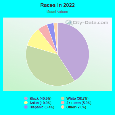
- 2,29540.9%Black
- 2,17038.7%White
- 56310.0%Asian
- 2835.0%Two or more races
- 1893.4%Hispanic or Latino
- 1122.0%Some other race
Distribution of median household income
![Distribution of median household income]()
- 428Less than $10,000
- 598$10,000 to $19,999
- 368$20,000 to $29,999
- 373$30,000 to $39,999
- 490$40,000 to $49,999
- 227$50,000 to $59,999
- 287$60,000 to $74,999
- 318$75,000 to $99,999
- 233$100,000 to $124,999
- 163$125,000 to $149,999
- 128$150,000 to $199,999
- 132$200,000 or more

Distribution of owner-occupied house/condo value
![Distribution of owner-occupied house/condo value]()
- 15Less than $50,000
- 623$50,000 to $99,999
- 114$100,000 to $149,999
- 145$150,000 to $199,999
- 92$200,000 to $249,999
- 38$250,000 to $299,999
- 143$300,000 to $399,999
- 121$400,000 to $499,999
- 73$500,000 to $749,999
- 286$750,000 to $999,999
- 15$1,000,000 or more

Distribution of rent paid by renters
![Distribution of rent paid by renters]()
- 255Less than $100
- 127$100 to $199
- 627$200 to $299
- 1,560$300 to $399
- 335$400 to $499
- 387$500 to $599
- 304$600 to $699
- 596$700 to $799
- 259$800 to $899
- 157$900 to $999
- 112$1,000 to $1,249
- 474$1,250 to $1,499
- 243$1,500 to $1,999
- 429$2,000 or more

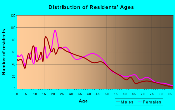
| Males: | 2,740 |
| Females: | 2,679 |
Males:
| This neighborhood: | 31.3 years |
| Whole city: | 32.7 years |
| This neighborhood: | 30.3 years |
| Whole city: | 34.2 years |
Average household size:
| Mount Auburn: | 2.0 people |
| Cincinnati: | 23.0 people |
Percentage of family households:
| Mount Auburn: | 21.0% |
| Cincinnati: | 33.3% |
| Here: | 17.0% |
| Cincinnati: | 23.1% |
Percentage of married-couple families with children (among all households):
| Mount Auburn: | 30.2% |
| Cincinnati: | 22.2% |
Percentage of single-mother households (among all households):
| Mount Auburn: | 32.1% |
| Cincinnati: | 22.0% |
Percentage of never married males 15 years old and over:
Percentage of never married females 15 years old and over:
| Mount Auburn: | 35.5% |
| Cincinnati: | 27.2% |
Percentage of never married females 15 years old and over:
| Mount Auburn: | 29.9% |
| city: | 29.6% |
Percentage of people that speak English not well or not at all:
| Mount Auburn: | 3.7% |
| Cincinnati: | 1.5% |
Percentage of people born in this state:
Percentage of people born in another U.S. state:
Percentage of native residents but born outside the U.S.:
Percentage of foreign born residents:
| Here: | 60.4% |
| Cincinnati: | 69.3% |
Percentage of people born in another U.S. state:
| Mount Auburn: | 28.5% |
| Cincinnati: | 23.5% |
Percentage of native residents but born outside the U.S.:
| Here: | 2.0% |
| city: | 1.0% |
Percentage of foreign born residents:
| Here: | 9.8% |
| Cincinnati: | 6.2% |
Owner-occupied
Renter-occupied

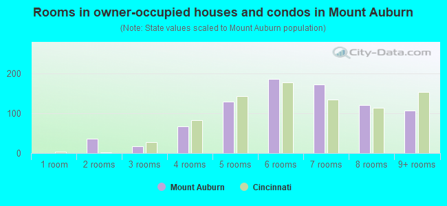
- Rooms in owner-occupied houses and condos in Mount Auburn
- 01 room
- 362 rooms
- 173 rooms
- 684 rooms
- 1295 rooms
- 1866 rooms
- 1727 rooms
- 1208 rooms
- 1069+ rooms
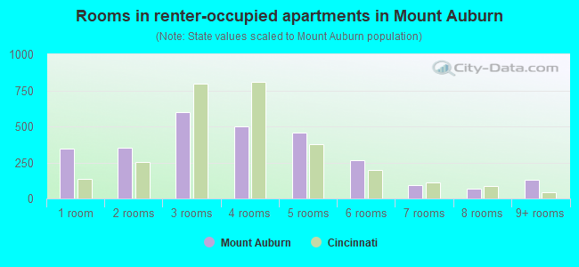
- Rooms in renter-occupied apartments in Mount Auburn
- 3471 room
- 3532 rooms
- 5963 rooms
- 5034 rooms
- 4575 rooms
- 2686 rooms
- 917 rooms
- 658 rooms
- 1289+ rooms
Owner-occupied
Renter-occupied
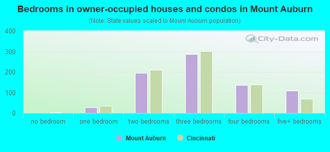
- Bedrooms in owner-occupied houses and condos in Mount Auburn
- 0no bedroom
- 281 bedroom
- 1962 bedrooms
- 2873 bedrooms
- 1374 bedrooms
- 1085+ bedrooms
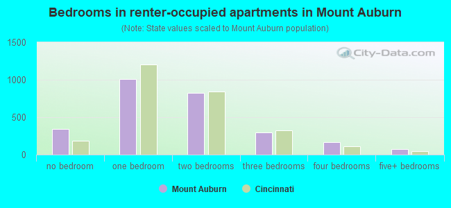
- Bedrooms in renter-occupied apartments in Mount Auburn
- 347no bedroom
- 1,0131 bedroom
- 8232 bedrooms
- 2963 bedrooms
- 1644 bedrooms
- 775+ bedrooms
Average number of cars or other vehicles available in houses/condos:
Average number of cars or other vehicles available in apartments:
| This neighborhood: | 1.5 |
| Cincinnati: | 1.9 |
Average number of cars or other vehicles available in apartments:
| Here: | 0.9 |
| city: | 1.0 |
Percentage of units with a mortgage:
| Mount Auburn: | 60.4% |
| Cincinnati: | 67.8% |
Average estimated value of detached houses in 2022 (22.2% of all units):
| Mount Auburn: | $217,006 |
| Ohio: | $254,366 |
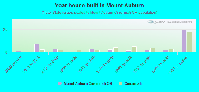
- Year house built in Mount Auburn
- 1032020 or later
- 7642010 to 2019
- 2892000 to 2009
- 541990 to 1999
- 2801980 to 1989
- 2431970 to 1979
- 1601960 to 1969
- 2281950 to 1959
- 2261940 to 1949
- 1,9751939 or earlier
City-data.com crime index for city in 2020 (higher means more crime):
| City: | 490.1 |
| U.S. average: | 219.5 |
Travel time to work (commute)
![Travel time to work (commute)]()
- 150Less than 5 minutes
- 5205 to 9 minutes
- 66610 to 14 minutes
- 21815 to 19 minutes
- 23320 to 24 minutes
- 12025 to 29 minutes
- 24030 to 34 minutes
- 10635 to 39 minutes
- 20640 to 44 minutes
- 47045 to 59 minutes
- 5660 to 89 minutes
- 22990 or more minutes

Means of transportation to work
![Means of transportation to work]()
- 67.5%1,703Drove a car alone
- 11.4%287Carpooled
- 10.1%255Bus
- 4.0%100Taxi
- 10.9%275Bicycle
- 9.1%229Walked
- 3.1%79Other means
- 8.5%214Worked at home

Time leaving home to go to work
![Time leaving home to go to work]()
- 9212:00 a.m. to 4:59 a.m.
- 1005:00 a.m. to 5:29 a.m.
- 485:30 a.m. to 5:59 a.m.
- 3286:00 a.m. to 6:29 a.m.
- 926:30 a.m. to 6:59 a.m.
- 2657:00 a.m. to 7:29 a.m.
- 2867:30 a.m. to 7:59 a.m.
- 2498:00 a.m. to 8:29 a.m.
- 3158:30 a.m. to 8:59 a.m.
- 1979:00 a.m. to 9:59 a.m.
- 14910:00 a.m. to 10:59 a.m.
- 8111:00 a.m. to 11:59 a.m.
- 32712:00 p.m. to 3:59 p.m.
- 3064:00 p.m. to 11:59 p.m.

Occupations of males:
- Percentage of males in management occupations (except farmers):
Here: 17.0% city: 11.2%
- Percentage of males in business and financial operations occupations:
Here: 5.4% city: 7.3%
- Percentage of males in computer and mathematical occupations:
Here: 1.9% city: 5.4%
- Percentage of males in architecture and engineering occupations:
Here: 3.4% city: 4.8%
- Percentage of males in legal occupations:
Here: 1.8% city: 1.4%
- Percentage of males in education, training, and library occupations:
Here: 5.3% city: 4.4%
- Percentage of males in arts, design, entertainment, sports, and media occupations:
Here: 3.5% city: 2.9%
- Percentage of males in healthcare practitioners and technical occupations:
Here: 1.2% city: 3.6%
- Percentage of males in service occupations:
Here: 16.1% city: 14.1%
- Percentage of males in sales and office occupations:
Here: 26.7% city: 15.7%
- Percentage of males in construction, extraction, and maintenance occupations:
Here: 2.1% city: 4.4%
- Percentage of males in production occupations:
Here: 4.8% city: 6.1%
- Percentage of males in transportation occupations:
Here: 6.5% city: 4.4%
- Percentage of males in material moving occupations:
Here: 2.6% city: 8.4%
Occupations of females:
- Percentage of females in management occupations (except farmers):
Here: 22.3% city: 9.5%
- Percentage of females in business and financial operations occupations:
Here: 5.7% city: 6.1%
- Percentage of females in computer and mathematical occupations:
Here: 2.7% city: 2.1%
- Percentage of females in architecture and engineering occupations:
Here: 4.0% city: 0.9%
- Percentage of females in life, physical, and social science occupations:
Here: 3.7% city: 1.8%
- Percentage of females in community and social services occupations:
Here: 5.2% city: 3.1%
- Percentage of females in education, training, and library occupations:
Here: 7.0% city: 8.4%
- Percentage of females in arts, design, entertainment, sports, and media occupations:
Here: 3.2% city: 2.8%
- Percentage of females in healthcare practitioners and technical occupations:
Here: 5.3% city: 10.6%
- Percentage of females in service occupations:
Here: 18.1% city: 20.8%
- Percentage of females in sales and office occupations:
Here: 12.8% city: 23.8%
- Percentage of females in transportation occupations:
Here: 2.1% city: 1.4%
- Percentage of females in material moving occupations:
Here: 6.8% city: 2.8%
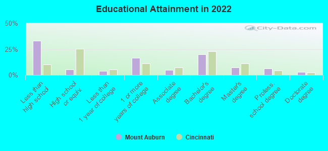
Education in this neighborhood (subdivision or community):
- Percentage of people 3 years and older in K-12 schools:
Mount Auburn: 28.5% Cincinnati: 15.0%
- Percentage of people 3 years and older in undergraduate colleges:
Mount Auburn: 13.3% Cincinnati: 10.0%
- Percentage of people 3 years and older in grad. or professional schools:
Mount Auburn: 9.8% Cincinnati: 3.0%
- Percentage of students K-12 enrolled in private schools:
Mount Auburn: 56.7% Cincinnati: 25.7%
Percentage of population below poverty level:
| Mount Auburn: | 28.3% |
| Cincinnati: | 26.6% |
Percentage of married-couple families with both working:
| Mount Auburn: | 379.9% |
| Cincinnati: | 77.0% |
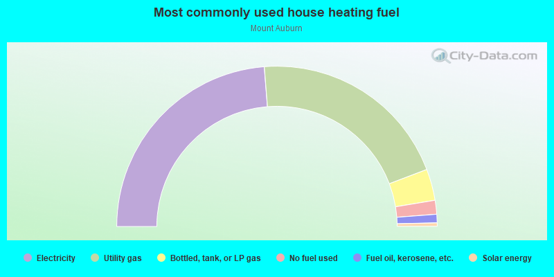
- 47.3%Electricity
- 40.8%Utility gas
- 6.3%Bottled, tank, or LP gas
- 2.8%No fuel used
- 1.7%Fuel oil, kerosene, etc.
- 0.7%Solar energy
Highways in this neighborhood:
US Hwy 42 (Reading Rd)
Length: 0.64 miles
Directions: N-S, SE-NW, SW-NE
Address range: 1601 to 2299
Directions: N-S, SE-NW, SW-NE
Address range: 1601 to 2299
Roads and streets:
Highland Ave
Length: 0.91 miles
Directions: N-S, SW-NE
Address range: 1600 to 2413
Directions: N-S, SW-NE
Address range: 1600 to 2413
Dorchester Ave
Length: 0.78 miles
Direction: E-W
Address range: 100 to 499
Direction: E-W
Address range: 100 to 499
Auburn Ave
Length: 0.74 miles
Direction: N-S
Address range: 1900 to 2427
Direction: N-S
Address range: 1900 to 2427
Young St
Length: 0.54 miles
Direction: N-S
Address range: 1602 to 2099
Direction: N-S
Address range: 1602 to 2099
Earnshaw Ave
Length: 0.51 miles
Directions: E-W, N-S, SE-NW
Address range: 200 to 399
Directions: E-W, N-S, SE-NW
Address range: 200 to 399
Mc Gregor Ave
Length: 0.49 miles
Direction: E-W
Address range: 200 to 399
Direction: E-W
Address range: 200 to 399
E Liberty St
Length: 0.47 miles
Direction: E-W
Address range: 318 to 561
Direction: E-W
Address range: 318 to 561
Boal St
Length: 0.47 miles
Direction: E-W
Address range: 300 to 599
Direction: E-W
Address range: 300 to 599
Milton St
Length: 0.46 miles
Direction: E-W
Address range: 300 to 599
Direction: E-W
Address range: 300 to 599
Kinsey Ave
Length: 0.46 miles
Direction: E-W
Address range: 100 to 399
Direction: E-W
Address range: 100 to 399
Burnet Ave
Length: 0.41 miles
Direction: N-S
Address range: 2000 to 2399
Direction: N-S
Address range: 2000 to 2399
Ringgold St
Length: 0.40 miles
Direction: E-W
Address range: 300 to 599
Direction: E-W
Address range: 300 to 599
Pueblo St
Length: 0.40 miles
Directions: E-W, SE-NW
Address range: 301 to 598
Directions: E-W, SE-NW
Address range: 301 to 598
Sycamore St
Length: 0.35 miles
Directions: E-W, N-S
Address range: 1624 to 1899
Directions: E-W, N-S
Address range: 1624 to 1899
Mc Cormick Pl
Length: 0.34 miles
Direction: E-W
Address range: 200 to 299
Direction: E-W
Address range: 200 to 299
Liberty Hill
Length: 0.33 miles
Directions: E-W, SW-NE
Address range: 400 to 599
Directions: E-W, SW-NE
Address range: 400 to 599
Helen St
Length: 0.32 miles
Direction: E-W
Address range: 200 to 339
Direction: E-W
Address range: 200 to 339
Carmalt St
Length: 0.32 miles
Directions: E-W, SE-NW, SW-NE
Address range: 200 to 599
Directions: E-W, SE-NW, SW-NE
Address range: 200 to 599
Mallon Ave
Length: 0.30 miles
Direction: N-S
Direction: N-S
Maplewood Ave
Length: 0.29 miles
Direction: N-S
Address range: 2200 to 2423
Direction: N-S
Address range: 2200 to 2423
Rice St
Length: 0.28 miles
Directions: N-S, SE-NW, SW-NE
Address range: 2181 to 2299
Directions: N-S, SE-NW, SW-NE
Address range: 2181 to 2299
Dorsey St
Length: 0.28 miles
Directions: E-W, SE-NW
Address range: 100 to 299
Directions: E-W, SE-NW
Address range: 100 to 299
Bodmann Ave
Length: 0.27 miles
Direction: E-W
Address range: 200 to 295
Direction: E-W
Address range: 200 to 295
Gilman Ave
Length: 0.27 miles
Direction: E-W
Address range: 200 to 299
Direction: E-W
Address range: 200 to 299
Alma St
Length: 0.26 miles
Direction: N-S
Direction: N-S
Goethe St
Length: 0.25 miles
Directions: E-W, SE-NW
Address range: 100 to 299
Directions: E-W, SE-NW
Address range: 100 to 299
Corporation Aly
Length: 0.25 miles
Direction: E-W
Address range: 401 to 599
Direction: E-W
Address range: 401 to 599
Ryan Ave
Length: 0.25 miles
Directions: E-W, N-S
Address range: 2000 to 2299
Directions: E-W, N-S
Address range: 2000 to 2299
Walker St
Length: 0.22 miles
Direction: N-S
Address range: 1800 to 1899
Direction: N-S
Address range: 1800 to 1899
Southern Ave
Length: 0.22 miles
Direction: E-W
Address range: 200 to 299
Direction: E-W
Address range: 200 to 299
Loth St
Length: 0.22 miles
Directions: N-S, SW-NE
Address range: 2200 to 2299
Directions: N-S, SW-NE
Address range: 2200 to 2299
East Aly
Length: 0.22 miles
Directions: N-S, SW-NE
Address range: 2264 to 2299
Directions: N-S, SW-NE
Address range: 2264 to 2299
Albion Pl
Length: 0.21 miles
Directions: E-W, N-S, SE-NW
Address range: 200 to 299
Directions: E-W, N-S, SE-NW
Address range: 200 to 299
Bigelow St
Length: 0.20 miles
Directions: E-W, N-S
Address range: 1900 to 1999
Directions: E-W, N-S
Address range: 1900 to 1999
Huntington Pl
Length: 0.20 miles
Direction: E-W
Address range: 100 to 199
Direction: E-W
Address range: 100 to 199
Mason St
Length: 0.20 miles
Direction: E-W
Address range: 100 to 199
Direction: E-W
Address range: 100 to 199
Wellington Pl
Length: 0.20 miles
Direction: E-W
Address range: 100 to 199
Direction: E-W
Address range: 100 to 199
Channing St
Length: 0.19 miles
Direction: E-W
Address range: 500 to 599
Direction: E-W
Address range: 500 to 599
Slack St
Length: 0.19 miles
Direction: E-W
Address range: 500 to 599
Direction: E-W
Address range: 500 to 599
Eleanor Pl
Length: 0.19 miles
Direction: N-S
Address range: 1800 to 2199
Direction: N-S
Address range: 1800 to 2199
Josephine St
Length: 0.18 miles
Direction: N-S
Address range: 1800 to 1899
Direction: N-S
Address range: 1800 to 1899
Inwood Pl
Length: 0.18 miles
Directions: E-W, N-S
Address range: 1 to 2399
Directions: E-W, N-S
Address range: 1 to 2399
Valencia St
Length: 0.17 miles
Directions: E-W, N-S
Address range: 100 to 199
Directions: E-W, N-S
Address range: 100 to 199
Gage St
Length: 0.17 miles
Directions: E-W, SE-NW
Address range: 100 to 199
Directions: E-W, SE-NW
Address range: 100 to 199
Elijah Aly
Length: 0.17 miles
Direction: N-S
Address range: 1700 to 1899
Direction: N-S
Address range: 1700 to 1899
Glencoe Pl
Length: 0.17 miles
Direction: E-W
Address range: 1 to 199
Direction: E-W
Address range: 1 to 199
Winkler St
Length: 0.16 miles
Direction: SE-NW
Address range: 100 to 199
Direction: SE-NW
Address range: 100 to 199
Seitz St
Length: 0.15 miles
Directions: E-W, SE-NW
Address range: 200 to 399
Directions: E-W, SE-NW
Address range: 200 to 399
Mansfield St
Length: 0.13 miles
Direction: N-S
Address range: 1600 to 1699
Direction: N-S
Address range: 1600 to 1699
Main St
Length: 0.13 miles
Direction: N-S
Direction: N-S
Hughes St
Length: 0.13 miles
Direction: N-S
Address range: 1704 to 1799
Direction: N-S
Address range: 1704 to 1799
Justis St
Length: 0.12 miles
Direction: E-W
Address range: 100 to 199
Direction: E-W
Address range: 100 to 199
St Joe St
Length: 0.11 miles
Directions: N-S, SE-NW
Directions: N-S, SE-NW
Mc Gregor Pl
Length: 0.11 miles
Direction: N-S
Address range: 2200 to 2299
Direction: N-S
Address range: 2200 to 2299
Audrey Ter
Length: 0.11 miles
Directions: N-S, SE-NW
Address range: 2000 to 2099
Directions: N-S, SE-NW
Address range: 2000 to 2099
Broadway St
Length: 0.10 miles
Directions: N-S, SE-NW
Address range: 1600 to 1699
Directions: N-S, SE-NW
Address range: 1600 to 1699
Excelsior St
Length: 0.10 miles
Direction: E-W
Direction: E-W
N Wendell Aly
Length: 0.10 miles
Direction: SW-NE
Address range: 2100 to 2199
Direction: SW-NE
Address range: 2100 to 2199
Walsh Aly
Length: 0.10 miles
Direction: SE-NW
Direction: SE-NW
Estelle St
Length: 0.10 miles
Direction: E-W
Address range: 1 to 99
Direction: E-W
Address range: 1 to 99
Bosler Aly
Length: 0.10 miles
Direction: SW-NE
Direction: SW-NE
Drake St
Length: 0.10 miles
Directions: N-S, SW-NE
Directions: N-S, SW-NE
Malvern Pl
Length: 0.10 miles
Direction: E-W
Address range: 100 to 199
Direction: E-W
Address range: 100 to 199
Alvin St
Length: 0.09 miles
Direction: N-S
Address range: 2000 to 2099
Direction: N-S
Address range: 2000 to 2099
Cumber St
Length: 0.08 miles
Direction: N-S
Address range: 1600 to 1699
Direction: N-S
Address range: 1600 to 1699
Danoridge St
Length: 0.08 miles
Direction: E-W
Direction: E-W
Cumberland St
Length: 0.07 miles
Direction: N-S
Address range: 2400 to 2417
Direction: N-S
Address range: 2400 to 2417
Le Roy Ct
Length: 0.07 miles
Direction: E-W
Address range: 1 to 200
Direction: E-W
Address range: 1 to 200
McGrew St
Length: 0.07 miles
Directions: E-W, SW-NE
Directions: E-W, SW-NE
Bunker Aly
Length: 0.07 miles
Direction: N-S
Direction: N-S
Auburncrest Ave
Length: 0.07 miles
Direction: N-S
Address range: 2300 to 2399
Direction: N-S
Address range: 2300 to 2399
Hiram St
Length: 0.06 miles
Direction: N-S
Direction: N-S
Thill St
Length: 0.06 miles
Direction: E-W
Address range: 6 to 99
Direction: E-W
Address range: 6 to 99
Schenk Aly
Length: 0.06 miles
Direction: E-W
Direction: E-W
Catlin Aly
Length: 0.06 miles
Direction: N-S
Direction: N-S
Lang St
Length: 0.06 miles
Direction: SW-NE
Direction: SW-NE
Schiller St
Length: 0.06 miles
Direction: E-W
Address range: 218 to 299
Direction: E-W
Address range: 218 to 299
Mulberry St
Length: 0.06 miles
Direction: E-W
Address range: 317 to 399
Direction: E-W
Address range: 317 to 399
Calumet St
Length: 0.06 miles
Direction: SW-NE
Address range: 2201 to 2299
Direction: SW-NE
Address range: 2201 to 2299
Edinburgh Pl
Length: 0.05 miles
Directions: E-W, N-S
Directions: E-W, N-S
Edinburg Pl
Length: 0.05 miles
Directions: E-W, N-S, SE-NW
Directions: E-W, N-S, SE-NW
McIlvaine St
Length: 0.05 miles
Direction: N-S
Direction: N-S
Park Pl
Length: 0.05 miles
Direction: E-W
Address range: 1 to 99
Direction: E-W
Address range: 1 to 99
Bamboo Aly
Length: 0.04 miles
Direction: E-W
Direction: E-W
Von Seggern Aly
Length: 0.03 miles
Direction: N-S
Direction: N-S
View Ct
Length: 0.03 miles
Direction: N-S
Address range: 1 to 98
Direction: N-S
Address range: 1 to 98
Decker Aly
Length: 0.03 miles
Direction: N-S
Direction: N-S
Beech Aly
Length: 0.03 miles
Direction: E-W
Direction: E-W
Adnored Ct
Length: 0.03 miles
Direction: N-S
Address range: 1 to 149
Direction: N-S
Address range: 1 to 149
Deronda Ct
Length: 0.03 miles
Direction: N-S
Address range: 1 to 99
Direction: N-S
Address range: 1 to 99
Auburn Ter
Length: 0.03 miles
Direction: N-S
Direction: N-S
Boyce Aly
Length: 0.03 miles
Direction: SW-NE
Direction: SW-NE
Ural Aly
Length: 0.03 miles
Direction: SE-NW
Direction: SE-NW
Pendleton Aly
Length: 0.02 miles
Directions: N-S, SE-NW
Directions: N-S, SE-NW