Stearns Park (Sterns Park) neighborhood in Freeport, New York (NY), 11510, 11520 detailed profile
Settings
X


Business Search - 14 Million verified businesses
Area: 1.824 square miles
Population: 17,840
Population density:
| Stearns Park (Sterns Park): | 9,780 people per square mile |
| Freeport: | 9,624 people per square mile |

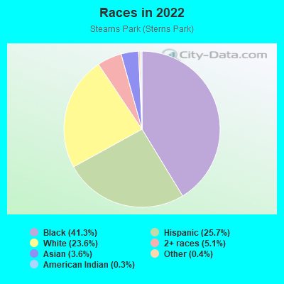
- 7,57641.3%Black
- 4,71325.7%Hispanic or Latino
- 4,33523.6%White
- 9265.1%Two or more races
- 6623.6%Asian
- 720.4%Some other race
- 510.3%American Indian
Distribution of median household income
![Distribution of median household income]()
- 404Less than $10,000
- 525$10,000 to $19,999
- 581$20,000 to $29,999
- 409$30,000 to $39,999
- 512$40,000 to $49,999
- 279$50,000 to $59,999
- 572$60,000 to $74,999
- 558$75,000 to $99,999
- 543$100,000 to $124,999
- 704$125,000 to $149,999
- 1,192$150,000 to $199,999
- 1,535$200,000 or more

Distribution of owner-occupied house/condo value
![Distribution of owner-occupied house/condo value]()
- 806Less than $50,000
- 916$50,000 to $99,999
- 1,104$100,000 to $149,999
- 576$150,000 to $199,999
- 315$200,000 to $249,999
- 162$250,000 to $299,999
- 463$300,000 to $399,999
- 1,130$400,000 to $499,999
- 2,777$500,000 to $749,999
- 804$750,000 to $999,999
- 3,201$1,000,000 or more

Distribution of rent paid by renters
![Distribution of rent paid by renters]()
- 32Less than $100
- 159$100 to $199
- 120$200 to $299
- 156$300 to $399
- 155$400 to $499
- 56$500 to $599
- 268$600 to $699
- 111$700 to $799
- 120$800 to $899
- 613$900 to $999
- 346$1,000 to $1,249
- 230$1,250 to $1,499
- 1,559$1,500 to $1,999
- 1,064$2,000 or more

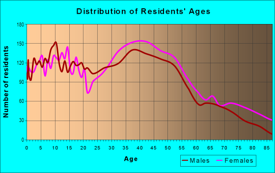
| Males: | 9,206 |
| Females: | 8,634 |
Males:
| This neighborhood: | 40.1 years |
| Whole city: | 37.9 years |
| This neighborhood: | 43.8 years |
| Whole city: | 40.1 years |
Average household size:
| Stearns Park (Sterns Park): | 3.2 people |
| Freeport: | 38.0 people |
Percentage of family households:
| Stearns Park (Sterns Park): | 44.2% |
| Freeport: | 44.6% |
| Here: | 55.1% |
| Freeport: | 42.4% |
Percentage of married-couple families with children (among all households):
| Stearns Park (Sterns Park): | 22.1% |
| Freeport: | 18.6% |
Percentage of single-mother households (among all households):
| Stearns Park (Sterns Park): | 15.4% |
| Freeport: | 9.7% |
Percentage of never married males 15 years old and over:
Percentage of never married females 15 years old and over:
| Stearns Park (Sterns Park): | 21.8% |
| Freeport: | 21.4% |
Percentage of never married females 15 years old and over:
| Stearns Park (Sterns Park): | 17.9% |
| village: | 18.8% |
Percentage of people that speak English not well or not at all:
| Stearns Park (Sterns Park): | 5.6% |
| Freeport: | 10.8% |
Percentage of people born in this state:
Percentage of people born in another U.S. state:
Percentage of native residents but born outside the U.S.:
Percentage of foreign born residents:
| Here: | 58.0% |
| Freeport: | 57.9% |
Percentage of people born in another U.S. state:
| Stearns Park (Sterns Park): | 5.3% |
| Freeport: | 4.9% |
Percentage of native residents but born outside the U.S.:
| Here: | 2.1% |
| village: | 2.3% |
Percentage of foreign born residents:
| Here: | 34.6% |
| Freeport: | 34.9% |
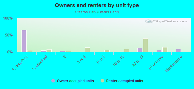
Owner-occupied
Renter-occupied

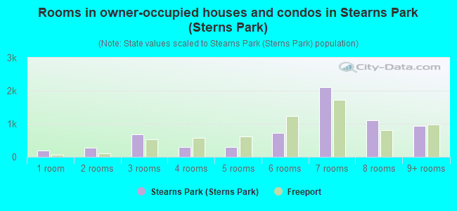
- Rooms in owner-occupied houses and condos in Stearns Park <
> - 1931 room
- 2662 rooms
- 6913 rooms
- 2964 rooms
- 2885 rooms
- 7206 rooms
- 2,1037 rooms
- 1,1058 rooms
- 9449+ rooms
- Rooms in renter-occupied apartments in Stearns Park <
> - 9611 room
- 1482 rooms
- 7183 rooms
- 4864 rooms
- 8925 rooms
- 2386 rooms
- 2897 rooms
- 1258 rooms
- 869+ rooms
Owner-occupied
Renter-occupied
- Bedrooms in owner-occupied houses and condos in Stearns Park <
> - 505no bedroom
- 7211 bedroom
- 3522 bedrooms
- 1,9133 bedrooms
- 2,5094 bedrooms
- 7055+ bedrooms
- Bedrooms in renter-occupied apartments in Stearns Park <
> - 1,353no bedroom
- 1,4011 bedroom
- 5632 bedrooms
- 2453 bedrooms
- 3684 bedrooms
- 715+ bedrooms
Average number of cars or other vehicles available in houses/condos:
Average number of cars or other vehicles available in apartments:
| This neighborhood: | 2.4 |
| Freeport: | 2.0 |
Average number of cars or other vehicles available in apartments:
| Here: | |
| village: |
Percentage of units with a mortgage:
| Stearns Park (Sterns Park): | 74.7% |
| Freeport: | 69.7% |
Average estimated value of detached houses in 2022 (85.3% of all units):
| Stearns Park (Sterns Park): | $609,150 |
| New York: | $476,719 |
- Year house built in Stearns Park <
> - 02020 or later
- 6702010 to 2019
- 7292000 to 2009
- 4991990 to 1999
- 2681980 to 1989
- 3411970 to 1979
- 2,3481960 to 1969
- 2,2881950 to 1959
- 6011940 to 1949
- 2,3361939 or earlier
City-data.com crime index for village in 2020 (higher means more crime):
| City: | 75.0 |
| U.S. average: | 219.5 |
Travel time to work (commute)
![Travel time to work (commute)]()
- 279Less than 5 minutes
- 5065 to 9 minutes
- 98910 to 14 minutes
- 1,03815 to 19 minutes
- 1,24020 to 24 minutes
- 60625 to 29 minutes
- 1,16830 to 34 minutes
- 27735 to 39 minutes
- 49140 to 44 minutes
- 1,20545 to 59 minutes
- 1,02760 to 89 minutes
- 85190 or more minutes

Means of transportation to work
![Means of transportation to work]()
- 69.3%6,601Drove a car alone
- 9.7%921Carpooled
- 5.1%490Bus
- 4.7%450Subway or elevated rail
- 8.4%805Long-distance train or commuter rail
- 3.3%314Light rail, streetcar or trolley
- 1.7%158Taxi
- 0.8%73Bicycle
- 7.9%755Walked
- 2.5%239Other means
- 9.0%862Worked at home

Time leaving home to go to work
![Time leaving home to go to work]()
- 42312:00 a.m. to 4:59 a.m.
- 3235:00 a.m. to 5:29 a.m.
- 3895:30 a.m. to 5:59 a.m.
- 9186:00 a.m. to 6:29 a.m.
- 8196:30 a.m. to 6:59 a.m.
- 1,2617:00 a.m. to 7:29 a.m.
- 1,0017:30 a.m. to 7:59 a.m.
- 1,7048:00 a.m. to 8:29 a.m.
- 5858:30 a.m. to 8:59 a.m.
- 5499:00 a.m. to 9:59 a.m.
- 24110:00 a.m. to 10:59 a.m.
- 11311:00 a.m. to 11:59 a.m.
- 34012:00 p.m. to 3:59 p.m.
- 6174:00 p.m. to 11:59 p.m.

Occupations of males:
- Percentage of males in management occupations (except farmers):
Here: 18.2% village: 7.7%
- Percentage of males in business and financial operations occupations:
Here: 2.5% village: 3.5%
- Percentage of males in computer and mathematical occupations:
Here: 6.1% village: 2.6%
- Percentage of males in architecture and engineering occupations:
Here: 3.1% village: 1.5%
- Percentage of males in community and social services occupations:
Here: 2.6% village: 0.4%
- Percentage of males in legal occupations:
Here: 3.5% village: 0.9%
- Percentage of males in education, training, and library occupations:
Here: 4.0% village: 2.5%
- Percentage of males in healthcare practitioners and technical occupations:
Here: 5.2% village: 3.4%
- Percentage of males in service occupations:
Here: 15.2% village: 21.9%
- Percentage of males in sales and office occupations:
Here: 10.4% village: 15.3%
- Percentage of males in construction, extraction, and maintenance occupations:
Here: 8.8% village: 11.4%
- Percentage of males in production occupations:
Here: 2.0% village: 3.2%
- Percentage of males in transportation occupations:
Here: 9.0% village: 11.5%
- Percentage of males in material moving occupations:
Here: 4.3% village: 4.1%
Occupations of females:
- Percentage of females in management occupations (except farmers):
Here: 14.9% village: 8.5%
- Percentage of females in business and financial operations occupations:
Here: 8.3% village: 4.5%
- Percentage of females in computer and mathematical occupations:
Here: 2.3% village: 1.8%
- Percentage of females in architecture and engineering occupations:
Here: 1.9% village: 1.1%
- Percentage of females in community and social services occupations:
Here: 1.9% village: 1.9%
- Percentage of females in legal occupations:
Here: 3.3% village: 0.8%
- Percentage of females in education, training, and library occupations:
Here: 7.2% village: 5.7%
- Percentage of females in arts, design, entertainment, sports, and media occupations:
Here: 1.8% village: 2.8%
- Percentage of females in healthcare practitioners and technical occupations:
Here: 14.2% village: 13.0%
- Percentage of females in service occupations:
Here: 22.8% village: 26.5%
- Percentage of females in sales and office occupations:
Here: 16.2% village: 24.5%
- Percentage of females in transportation occupations:
Here: 1.8% village: 2.2%
- Percentage of females in material moving occupations:
Here: 2.1% village: 2.0%
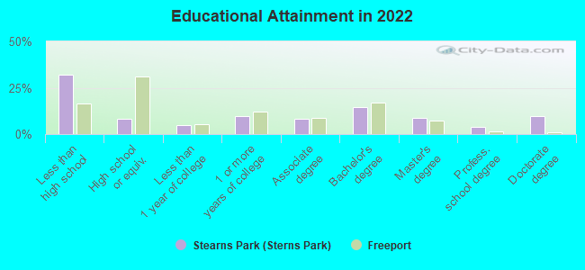
Education in this neighborhood (subdivision or community):
- Percentage of people 3 years and older in K-12 schools:
Stearns Park (Sterns Park): 27.2% Freeport: 16.3%
- Percentage of people 3 years and older in undergraduate colleges:
Stearns Park (Sterns Park): 6.1% Freeport: 4.3%
- Percentage of people 3 years and older in grad. or professional schools:
Stearns Park (Sterns Park): 5.7% Freeport: 1.4%
- Percentage of students K-12 enrolled in private schools:
Stearns Park (Sterns Park): 49.6% Freeport: 4.9%
Percentage of population below poverty level:
| Stearns Park (Sterns Park): | 5.6% |
| Freeport: | 6.9% |
Median year owner moved in (as recorded in 2022):
| Stearns Park (Sterns Park): | 2004 |
| Freeport: | 2005 |
Percentage of married-couple families with both working:
| Stearns Park (Sterns Park): | 97.3% |
| Freeport: | 85.5% |
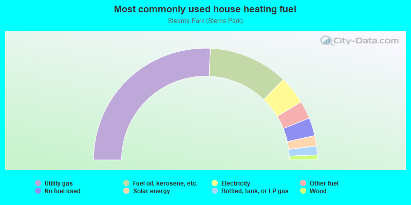
- 51.5%Utility gas
- 23.1%Fuel oil, kerosene, etc.
- 8.2%Electricity
- 5.2%Other fuel
- 5.2%No fuel used
- 3.0%Solar energy
- 2.6%Bottled, tank, or LP gas
- 1.4%Wood
Highways in this neighborhood:
State Hwy 27 (Sunrise Hwy)
Length: 0.72 miles
Direction: E-W
Address range: 27 to 700
Direction: E-W
Address range: 27 to 700
Roads and streets:
S Bayview Ave
Length: 1.67 miles
Directions: N-S, SE-NW, SW-NE
Address range: 1 to 773
Directions: N-S, SE-NW, SW-NE
Address range: 1 to 773
Atlantic Ave
Length: 1.30 miles
Directions: E-W, SW-NE
Address range: 256 to 1199
Directions: E-W, SW-NE
Address range: 256 to 1199
N Brookside Ave
Length: 1.07 miles
Directions: N-S, SE-NW, SW-NE
Address range: 1 to 599
Directions: N-S, SE-NW, SW-NE
Address range: 1 to 599
Pennsylvania Ave
Length: 1.06 miles
Direction: N-S
Address range: 1 to 465
Direction: N-S
Address range: 1 to 465
N Long Beach Ave
Length: 1.00 miles
Directions: N-S, SE-NW
Address range: 1 to 479
Directions: N-S, SE-NW
Address range: 1 to 479
Wallace St
Length: 0.98 miles
Directions: N-S, SE-NW
Address range: 1 to 449
Directions: N-S, SE-NW
Address range: 1 to 449
Southside Ave
Length: 0.86 miles
Directions: E-W, N-S, SE-NW, SW-NE
Address range: 282 to 599
Directions: E-W, N-S, SE-NW, SW-NE
Address range: 282 to 599
S Brookside Ave
Length: 0.86 miles
Directions: N-S, SE-NW, SW-NE
Address range: 1 to 399
Directions: N-S, SE-NW, SW-NE
Address range: 1 to 399
Archer St
Length: 0.85 miles
Direction: E-W
Address range: 279 to 599
Direction: E-W
Address range: 279 to 599
W Merrick Rd
Length: 0.84 miles
Directions: E-W, SW-NE
Address range: 221 to 499
Directions: E-W, SW-NE
Address range: 221 to 499
Rose St
Length: 0.83 miles
Directions: E-W, N-S, SW-NE
Address range: 112 to 399
Directions: E-W, N-S, SW-NE
Address range: 112 to 399
Park Ave
Length: 0.82 miles
Directions: N-S, SE-NW
Address range: 1 to 398
Directions: N-S, SE-NW
Address range: 1 to 398
S Long Beach Ave
Length: 0.82 miles
Direction: N-S
Address range: 1 to 353
Direction: N-S
Address range: 1 to 353
Porterfield Pl
Length: 0.80 miles
Direction: E-W
Address range: 1 to 264
Direction: E-W
Address range: 1 to 264
Maryland Ave
Length: 0.79 miles
Directions: E-W, N-S, SE-NW, SW-NE
Address range: 1 to 436
Directions: E-W, N-S, SE-NW, SW-NE
Address range: 1 to 436
Pine St
Length: 0.78 miles
Direction: E-W
Address range: 167 to 435
Direction: E-W
Address range: 167 to 435
Randall Ave
Length: 0.78 miles
Directions: E-W, N-S, SE-NW
Address range: 109 to 367
Directions: E-W, N-S, SE-NW
Address range: 109 to 367
Washington St
Length: 0.77 miles
Directions: E-W, N-S
Address range: 1 to 1098
Directions: E-W, N-S
Address range: 1 to 1098
Lena Ave
Length: 0.77 miles
Directions: E-W, SW-NE
Address range: 99 to 360
Directions: E-W, SW-NE
Address range: 99 to 360
Lexington Ave
Length: 0.76 miles
Direction: E-W
Address range: 1 to 299
Direction: E-W
Address range: 1 to 299
W Seaman Ave
Length: 0.75 miles
Direction: E-W
Address range: 100 to 339
Direction: E-W
Address range: 100 to 339
Delaware Ave
Length: 0.73 miles
Directions: E-W, N-S, SE-NW, SW-NE
Address range: 1 to 299
Directions: E-W, N-S, SE-NW, SW-NE
Address range: 1 to 299
Maxson Ave
Length: 0.70 miles
Direction: E-W
Address range: 1 to 248
Direction: E-W
Address range: 1 to 248
Wilson Pl
Length: 0.64 miles
Directions: E-W, SE-NW, SW-NE
Address range: 1 to 199
Directions: E-W, SE-NW, SW-NE
Address range: 1 to 199
Moore Ave
Length: 0.63 miles
Direction: E-W
Address range: 122 to 299
Direction: E-W
Address range: 122 to 299
Milburn Ave
Length: 0.63 miles
Directions: N-S, SE-NW
Address range: 2900 to 3232
Directions: N-S, SE-NW
Address range: 2900 to 3232
Prince Ave
Length: 0.60 miles
Direction: E-W
Address range: 91 to 316
Direction: E-W
Address range: 91 to 316
Westend Ave
Length: 0.60 miles
Direction: SE-NW
Address range: 1 to 299
Direction: SE-NW
Address range: 1 to 299
Northern Blvd
Length: 0.57 miles
Direction: E-W
Address range: 901 to 1144
Direction: E-W
Address range: 901 to 1144
N Bayview Ave
Length: 0.53 miles
Directions: E-W, SE-NW
Address range: 9 to 182
Directions: E-W, SE-NW
Address range: 9 to 182
Pearsall Ave
Length: 0.49 miles
Direction: E-W
Address range: 1 to 160
Direction: E-W
Address range: 1 to 160
California Ave
Length: 0.49 miles
Direction: E-W
Address range: 1 to 199
Direction: E-W
Address range: 1 to 199
Whaley St
Length: 0.47 miles
Direction: E-W
Address range: 125 to 265
Direction: E-W
Address range: 125 to 265
Sigmond St
Length: 0.46 miles
Direction: E-W
Address range: 288 to 505
Direction: E-W
Address range: 288 to 505
Meister Blvd
Length: 0.46 miles
Directions: E-W, N-S, SW-NE
Address range: 1 to 262
Directions: E-W, N-S, SW-NE
Address range: 1 to 262
Madison Ave
Length: 0.45 miles
Direction: N-S
Address range: 1 to 199
Direction: N-S
Address range: 1 to 199
Mc Kinley St
Length: 0.45 miles
Direction: E-W
Address range: 901 to 1099
Direction: E-W
Address range: 901 to 1099
Van Buren St
Length: 0.45 miles
Direction: E-W
Address range: 901 to 1086
Direction: E-W
Address range: 901 to 1086
Hayes St
Length: 0.45 miles
Direction: E-W
Address range: 901 to 1099
Direction: E-W
Address range: 901 to 1099
Jackson St
Length: 0.44 miles
Direction: E-W
Address range: 901 to 1098
Direction: E-W
Address range: 901 to 1098
Mount Joy Ave
Length: 0.43 miles
Direction: E-W
Address range: 117 to 299
Direction: E-W
Address range: 117 to 299
New York Ave
Length: 0.43 miles
Direction: N-S
Address range: 1 to 200
Direction: N-S
Address range: 1 to 200
Connecticut Ave
Length: 0.43 miles
Direction: N-S
Address range: 1 to 200
Direction: N-S
Address range: 1 to 200
Smith St
Length: 0.42 miles
Direction: E-W
Address range: 250 to 376
Direction: E-W
Address range: 250 to 376
Willowbrook Ln
Length: 0.42 miles
Directions: E-W, N-S, SW-NE
Address range: 1 to 56
Directions: E-W, N-S, SW-NE
Address range: 1 to 56
Centre St
Length: 0.40 miles
Direction: E-W
Address range: 1 to 155
Direction: E-W
Address range: 1 to 155
Roosevelt Ave
Length: 0.39 miles
Direction: N-S
Address range: 1 to 173
Direction: N-S
Address range: 1 to 173
Eastern Pkwy
Length: 0.39 miles
Direction: SE-NW
Address range: 3021 to 3229
Direction: SE-NW
Address range: 3021 to 3229
Steele Blvd
Length: 0.38 miles
Directions: E-W, N-S
Address range: 1003 to 1154
Directions: E-W, N-S
Address range: 1003 to 1154
Hastings St (Hastings Pkwy)
Length: 0.36 miles
Direction: E-W
Address range: 1010 to 1150
Direction: E-W
Address range: 1010 to 1150
Putnam Ave
Length: 0.35 miles
Direction: E-W
Address range: 124 to 299
Direction: E-W
Address range: 124 to 299
Cornwell Ave
Length: 0.34 miles
Direction: E-W
Address range: 29 to 1199
Direction: E-W
Address range: 29 to 1199
Cary Pl
Length: 0.34 miles
Direction: E-W
Address range: 1 to 199
Direction: E-W
Address range: 1 to 199
Elizabeth St
Length: 0.34 miles
Direction: E-W
Address range: 1000 to 1146
Direction: E-W
Address range: 1000 to 1146
Evans Ave
Length: 0.33 miles
Directions: E-W, SW-NE
Address range: 101 to 220
Directions: E-W, SW-NE
Address range: 101 to 220
Craig Ave
Length: 0.33 miles
Direction: E-W
Address range: 112 to 240
Direction: E-W
Address range: 112 to 240
Pacific St
Length: 0.33 miles
Directions: E-W, SW-NE
Address range: 1003 to 1141
Directions: E-W, SW-NE
Address range: 1003 to 1141
Virginia Ave
Length: 0.32 miles
Direction: N-S
Address range: 1 to 139
Direction: N-S
Address range: 1 to 139
Hampton Pl
Length: 0.31 miles
Direction: E-W
Address range: 1 to 99
Direction: E-W
Address range: 1 to 99
Ray St
Length: 0.30 miles
Direction: E-W
Address range: 411 to 599
Direction: E-W
Address range: 411 to 599
Green Ave
Length: 0.30 miles
Direction: E-W
Address range: 150 to 299
Direction: E-W
Address range: 150 to 299
Eastern Blvd
Length: 0.30 miles
Directions: E-W, N-S, SE-NW
Address range: 105 to 3023
Directions: E-W, N-S, SE-NW
Address range: 105 to 3023
Russell Pl
Length: 0.29 miles
Directions: E-W, SW-NE
Address range: 1 to 102
Directions: E-W, SW-NE
Address range: 1 to 102
Elliot Pl
Length: 0.27 miles
Direction: N-S
Address range: 1 to 149
Direction: N-S
Address range: 1 to 149
Locust Ave
Length: 0.26 miles
Direction: N-S
Address range: 220 to 329
Direction: N-S
Address range: 220 to 329
Grand Blvd
Length: 0.25 miles
Direction: SE-NW
Address range: 3108 to 3230
Direction: SE-NW
Address range: 3108 to 3230
Juanita Ave
Length: 0.23 miles
Direction: N-S
Address range: 146 to 244
Direction: N-S
Address range: 146 to 244
Beverly Pkwy
Length: 0.23 miles
Directions: N-S, SE-NW
Address range: 1 to 100
Directions: N-S, SE-NW
Address range: 1 to 100
Stirling Ave
Length: 0.23 miles
Direction: N-S
Address range: 1 to 130
Direction: N-S
Address range: 1 to 130
Irving Ave
Length: 0.22 miles
Direction: N-S
Address range: 1 to 149
Direction: N-S
Address range: 1 to 149
Morton Ave
Length: 0.22 miles
Direction: E-W
Address range: 1 to 99
Direction: E-W
Address range: 1 to 99
Frankel Ave
Length: 0.22 miles
Direction: E-W
Address range: 1 to 99
Direction: E-W
Address range: 1 to 99
Jefferson St
Length: 0.22 miles
Direction: E-W
Address range: 1003 to 1098
Direction: E-W
Address range: 1003 to 1098
Elinor Pl
Length: 0.21 miles
Direction: E-W
Address range: 1 to 99
Direction: E-W
Address range: 1 to 99
Oakfield Ave
Length: 0.21 miles
Directions: N-S, SE-NW
Address range: 1 to 79
Directions: N-S, SE-NW
Address range: 1 to 79
Tanglewood Ln
Length: 0.20 miles
Directions: E-W, N-S, SE-NW, SW-NE
Address range: 1 to 30
Directions: E-W, N-S, SE-NW, SW-NE
Address range: 1 to 30
Lester Ave
Length: 0.19 miles
Direction: N-S
Address range: 1 to 109
Direction: N-S
Address range: 1 to 109
Meadow Ln
Length: 0.18 miles
Directions: E-W, N-S, SE-NW
Address range: 1 to 29
Directions: E-W, N-S, SE-NW
Address range: 1 to 29
Anchor St
Length: 0.18 miles
Direction: SW-NE
Address range: 1 to 53
Direction: SW-NE
Address range: 1 to 53
Jackson Pl
Length: 0.18 miles
Direction: E-W
Address range: 13 to 1199
Direction: E-W
Address range: 13 to 1199
Morris St
Length: 0.18 miles
Direction: E-W
Address range: 1 to 99
Direction: E-W
Address range: 1 to 99
Moody Ave
Length: 0.17 miles
Direction: N-S
Address range: 1 to 299
Direction: N-S
Address range: 1 to 299
Florence Ave
Length: 0.17 miles
Directions: E-W, SW-NE
Address range: 1 to 99
Directions: E-W, SW-NE
Address range: 1 to 99
Milburn Ct
Length: 0.17 miles
Direction: E-W
Address range: 1 to 99
Direction: E-W
Address range: 1 to 99
Triangle Pl
Length: 0.17 miles
Direction: SW-NE
Address range: 1 to 99
Direction: SW-NE
Address range: 1 to 99
Washington Pl
Length: 0.16 miles
Direction: E-W
Address range: 1 to 1199
Direction: E-W
Address range: 1 to 1199
Sweezy Ave
Length: 0.16 miles
Direction: N-S
Address range: 143 to 212
Direction: N-S
Address range: 143 to 212
Johnson Pl
Length: 0.15 miles
Direction: E-W
Address range: 1 to 99
Direction: E-W
Address range: 1 to 99
Byrd Pl
Length: 0.15 miles
Direction: SE-NW
Address range: 3159 to 3233
Direction: SE-NW
Address range: 3159 to 3233
Stokes Ave
Length: 0.15 miles
Direction: N-S
Address range: 140 to 232
Direction: N-S
Address range: 140 to 232
Terrace Ave
Length: 0.15 miles
Direction: E-W
Address range: 1 to 72
Direction: E-W
Address range: 1 to 72
Jefferson Pl (Jefferson St)
Length: 0.15 miles
Direction: E-W
Address range: 1 to 99
Direction: E-W
Address range: 1 to 99
Dock Dr
Length: 0.13 miles
Direction: SW-NE
Address range: 1 to 99
Direction: SW-NE
Address range: 1 to 99
Laurel Ave
Length: 0.12 miles
Direction: SE-NW
Address range: 2900 to 2956
Direction: SE-NW
Address range: 2900 to 2956
Elm Pl
Length: 0.12 miles
Direction: N-S
Address range: 1 to 46
Direction: N-S
Address range: 1 to 46
Gerald Ave
Length: 0.12 miles
Direction: SE-NW
Address range: 1 to 99
Direction: SE-NW
Address range: 1 to 99
Onslow Pl
Length: 0.12 miles
Direction: N-S
Address range: 1 to 50
Direction: N-S
Address range: 1 to 50
Shelly St
Length: 0.12 miles
Direction: E-W
Address range: 1 to 49
Direction: E-W
Address range: 1 to 49
S Meister Blvd
Length: 0.12 miles
Directions: E-W, N-S, SE-NW
Address range: 181 to 299
Directions: E-W, N-S, SE-NW
Address range: 181 to 299
Brunella St
Length: 0.11 miles
Directions: N-S, SE-NW, SW-NE
Address range: 1 to 99
Directions: N-S, SE-NW, SW-NE
Address range: 1 to 99
Hayes Pl
Length: 0.11 miles
Direction: E-W
Address range: 1093 to 1139
Direction: E-W
Address range: 1093 to 1139
Buchanan St
Length: 0.11 miles
Direction: N-S
Address range: 1 to 53
Direction: N-S
Address range: 1 to 53
Tulip Ave
Length: 0.11 miles
Direction: SE-NW
Address range: 2900 to 2948
Direction: SE-NW
Address range: 2900 to 2948
S Bay Ave
Length: 0.10 miles
Direction: N-S
Address range: 1 to 45
Direction: N-S
Address range: 1 to 45
Van Buren Pl
Length: 0.09 miles
Direction: E-W
Address range: 1087 to 1199
Direction: E-W
Address range: 1087 to 1199
Carnation Ave
Length: 0.09 miles
Direction: SE-NW
Address range: 2900 to 2939
Direction: SE-NW
Address range: 2900 to 2939
Muriel St
Length: 0.09 miles
Direction: N-S
Address range: 1 to 99
Direction: N-S
Address range: 1 to 99
Brooklyn Ave
Length: 0.09 miles
Direction: E-W
Address range: 111 to 140
Direction: E-W
Address range: 111 to 140
Dahlia Ave
Length: 0.09 miles
Direction: SE-NW
Address range: 2900 to 2939
Direction: SE-NW
Address range: 2900 to 2939
Forbes Pl
Length: 0.09 miles
Direction: SE-NW
Address range: 1 to 33
Direction: SE-NW
Address range: 1 to 33
Locust Pl
Length: 0.08 miles
Direction: SE-NW
Direction: SE-NW
Cornwell Pl
Length: 0.08 miles
Direction: SE-NW
Address range: 3060 to 3099
Direction: SE-NW
Address range: 3060 to 3099
Mayflower Ct
Length: 0.07 miles
Direction: E-W
Address range: 1 to 29
Direction: E-W
Address range: 1 to 29
Meadowbrook Ct
Length: 0.07 miles
Direction: E-W
Address range: 1 to 99
Direction: E-W
Address range: 1 to 99
Jeanette Ave
Length: 0.06 miles
Direction: SE-NW
Address range: 1 to 99
Direction: SE-NW
Address range: 1 to 99
Hansome Pl
Length: 0.06 miles
Direction: N-S
Address range: 1 to 30
Direction: N-S
Address range: 1 to 30
Taft Pl
Length: 0.06 miles
Direction: N-S
Address range: 1 to 20
Direction: N-S
Address range: 1 to 20
New St
Length: 0.06 miles
Direction: E-W
Direction: E-W
Mayfair Ct
Length: 0.06 miles
Direction: E-W
Address range: 1 to 30
Direction: E-W
Address range: 1 to 30
William Pl
Length: 0.05 miles
Direction: SE-NW
Address range: 1 to 19
Direction: SE-NW
Address range: 1 to 19
May Ct
Length: 0.04 miles
Directions: N-S, SE-NW
Address range: 1 to 49
Directions: N-S, SE-NW
Address range: 1 to 49
Mc Kinley Pl
Length: 0.04 miles
Direction: N-S
Direction: N-S
Joan Ct
Length: 0.04 miles
Direction: SE-NW
Address range: 1 to 50
Direction: SE-NW
Address range: 1 to 50
Gold Cir
Length: 0.04 miles
Direction: SE-NW
Address range: 1 to 10
Direction: SE-NW
Address range: 1 to 10
Hastings Pl
Length: 0.04 miles
Directions: E-W, N-S, SE-NW
Address range: 1 to 1172
Directions: E-W, N-S, SE-NW
Address range: 1 to 1172
Moore Cir
Length: 0.03 miles
Direction: E-W
Address range: 1 to 665
Direction: E-W
Address range: 1 to 665
Riverside Dr
Length: 0.03 miles
Direction: E-W
Direction: E-W
Delaware Cir
Length: 0.03 miles
Direction: E-W
Address range: 1 to 99
Direction: E-W
Address range: 1 to 99
Sterling Ave
Length: 0.02 miles
Direction: N-S
Address range: 1 to 99
Direction: N-S
Address range: 1 to 99
Midwood Pl
Length: 0.02 miles
Direction: N-S
Address range: 1 to 18
Direction: N-S
Address range: 1 to 18
Central Ave
Length: 0.02 miles
Direction: N-S
Direction: N-S
Railroad features:
Long Island RR
Length: 0.70 miles
Direction: E-W
Direction: E-W
Other features:
Millburn Crk
Length: 0.19 miles
Directions: N-S, SE-NW, SW-NE
Directions: N-S, SE-NW, SW-NE
Milburn Crk
Length: 0.03 miles
Directions: N-S, SW-NE
Directions: N-S, SW-NE