West End neighborhood in Cincinnati, Ohio (OH), 45203, 45214 detailed profile
Settings
X


Business Search - 14 Million verified businesses
Area: 0.866 square miles
Population: 7,099
Population density:
| West End: | 8,198 people per square mile |
| Cincinnati: | 3,970 people per square mile |

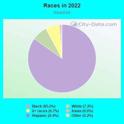
- 6,10285.0%Black
- 5147.2%White
- 4836.7%Two or more races
- 440.6%Asian
- 270.4%Hispanic or Latino
- 110.2%Some other race
Median household income in 2022:
| West End: | $18,327 |
| Cincinnati: | $48,130 |
Distribution of median household income
![Distribution of median household income]()
- 827Less than $10,000
- 1,450$10,000 to $19,999
- 632$20,000 to $29,999
- 172$30,000 to $39,999
- 437$40,000 to $49,999
- 47$50,000 to $59,999
- 156$60,000 to $74,999
- 86$75,000 to $99,999
- 8$100,000 to $124,999
- 45$150,000 to $199,999
- 89$200,000 or more

Distribution of owner-occupied house/condo value
![Distribution of owner-occupied house/condo value]()
- 56$50,000 to $99,999
- 45$200,000 to $249,999
- 89$500,000 to $749,999
- 67$750,000 to $999,999

Distribution of rent paid by renters
![Distribution of rent paid by renters]()
- 184Less than $100
- 171$100 to $199
- 62$200 to $299
- 219$300 to $399
- 183$400 to $499
- 686$500 to $599
- 1,886$600 to $699
- 242$700 to $799
- 32$800 to $899
- 50$900 to $999
- 86$1,000 to $1,249
- 164$1,250 to $1,499
- 217$1,500 to $1,999
- 100$2,000 or more

Median rent in 2022:
| West End: | $650 |
| Cincinnati: | $777 |
| Males: | 2,852 |
| Females: | 4,247 |
Males:
| This neighborhood: | 28.9 years |
| Whole city: | 32.7 years |
| This neighborhood: | 29.3 years |
| Whole city: | 34.2 years |
Average household size:
| West End: | 1.8 people |
| Cincinnati: | 23.0 people |
Percentage of family households:
| West End: | 36.2% |
| Cincinnati: | 33.3% |
| Here: | 7.0% |
| Cincinnati: | 23.1% |
Percentage of married-couple families with children (among all households):
| West End: | 2.4% |
| Cincinnati: | 22.2% |
Percentage of single-mother households (among all households):
| West End: | 53.7% |
| Cincinnati: | 22.0% |
Percentage of never married males 15 years old and over:
Percentage of never married females 15 years old and over:
| West End: | 24.9% |
| Cincinnati: | 27.2% |
Percentage of never married females 15 years old and over:
| West End: | 35.9% |
| city: | 29.6% |
Percentage of people that speak English not well or not at all:
| West End: | 0.0% |
| Cincinnati: | 1.5% |
Percentage of people born in this state:
Percentage of people born in another U.S. state:
Percentage of native residents but born outside the U.S.:
Percentage of foreign born residents:
| Here: | 82.2% |
| Cincinnati: | 69.3% |
Percentage of people born in another U.S. state:
| West End: | 13.9% |
| Cincinnati: | 23.5% |
Percentage of native residents but born outside the U.S.:
| Here: | 3.1% |
| city: | 1.0% |
Percentage of foreign born residents:
| Here: | 1.4% |
| Cincinnati: | 6.2% |
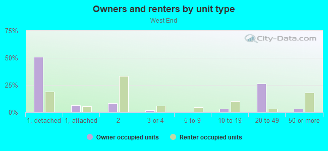
Owner-occupied
Renter-occupied

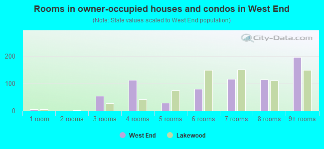
- Rooms in owner-occupied houses and condos in West End
- 01 room
- 02 rooms
- 03 rooms
- 884 rooms
- 555 rooms
- 446 rooms
- 07 rooms
- 08 rooms
- 669+ rooms
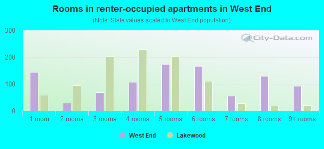
- Rooms in renter-occupied apartments in West End
- 1711 room
- 2962 rooms
- 3743 rooms
- 1,8394 rooms
- 9665 rooms
- 1636 rooms
- 497 rooms
- 08 rooms
- 09+ rooms
Owner-occupied
Renter-occupied
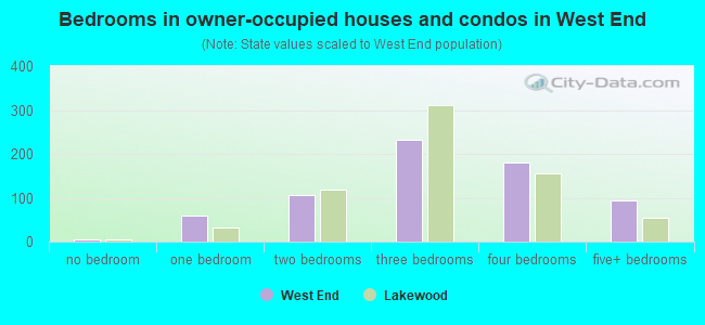
- Bedrooms in owner-occupied houses and condos in West End
- 0no bedroom
- 881 bedroom
- 442 bedrooms
- 1223 bedrooms
- 04 bedrooms
- 05+ bedrooms
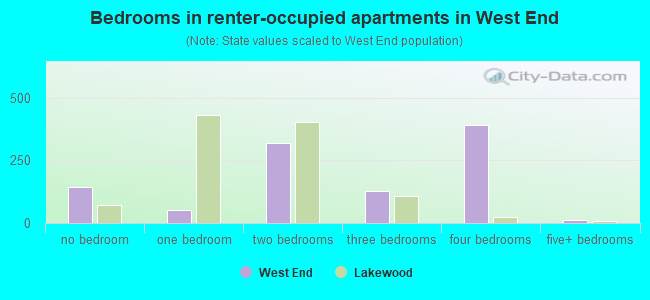
- Bedrooms in renter-occupied apartments in West End
- 171no bedroom
- 9111 bedroom
- 1,5432 bedrooms
- 1,1843 bedrooms
- 494 bedrooms
- 05+ bedrooms
Average number of cars or other vehicles available in houses/condos:
Average number of cars or other vehicles available in apartments:
| This neighborhood: | |
| Cincinnati: |
Average number of cars or other vehicles available in apartments:
| Here: | 0.7 |
| city: | 1.0 |
Percentage of units with a mortgage:
| West End: | 39.1% |
| Cincinnati: | 67.8% |
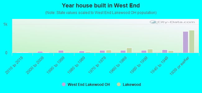
- Year house built in West End
- 02020 or later
- 1162010 to 2019
- 02000 to 2009
- 541990 to 1999
- 851980 to 1989
- 5761970 to 1979
- 2,7041960 to 1969
- 7791950 to 1959
- 461940 to 1949
- 3501939 or earlier
City-data.com crime index for city in 2020 (higher means more crime):
| City: | 490.1 |
| U.S. average: | 219.5 |
Travel time to work (commute)
![Travel time to work (commute)]()
- 135Less than 5 minutes
- 3975 to 9 minutes
- 29010 to 14 minutes
- 77715 to 19 minutes
- 44520 to 24 minutes
- 40725 to 29 minutes
- 25930 to 34 minutes
- 5445 to 59 minutes
- 7960 to 89 minutes

Means of transportation to work
![Means of transportation to work]()
- 79.0%1,737Drove a car alone
- 9.2%202Carpooled
- 9.9%218Bus
- 2.5%55Light rail, streetcar or trolley
- 1.0%22Bicycle
- 1.4%31Walked
- 0.3%7Worked at home

Time leaving home to go to work
![Time leaving home to go to work]()
- 835:00 a.m. to 5:29 a.m.
- 2295:30 a.m. to 5:59 a.m.
- 956:00 a.m. to 6:29 a.m.
- 1726:30 a.m. to 6:59 a.m.
- 4597:00 a.m. to 7:29 a.m.
- 2747:30 a.m. to 7:59 a.m.
- 498:00 a.m. to 8:29 a.m.
- 388:30 a.m. to 8:59 a.m.
- 1559:00 a.m. to 9:59 a.m.
- 9410:00 a.m. to 10:59 a.m.
- 13511:00 a.m. to 11:59 a.m.
- 55912:00 p.m. to 3:59 p.m.
- 2224:00 p.m. to 11:59 p.m.

Occupations of males:
- Percentage of males in management occupations (except farmers):
Here: 1.7% city: 11.2%
- Percentage of males in business and financial operations occupations:
Here: 7.8% city: 7.3%
- Percentage of males in computer and mathematical occupations:
Here: 1.8% city: 5.4%
- Percentage of males in education, training, and library occupations:
Here: 13.7% city: 4.4%
- Percentage of males in healthcare practitioners and technical occupations:
Here: 2.5% city: 3.6%
- Percentage of males in service occupations:
Here: 52.9% city: 14.1%
- Percentage of males in construction, extraction, and maintenance occupations:
Here: 1.8% city: 4.4%
- Percentage of males in production occupations:
Here: 16.3% city: 6.1%
- Percentage of males in transportation occupations:
Here: 7.8% city: 4.4%
Occupations of females:
- Percentage of females in management occupations (except farmers):
Here: 21.7% city: 9.5%
- Percentage of females in life, physical, and social science occupations:
Here: 2.2% city: 1.8%
- Percentage of females in education, training, and library occupations:
Here: 1.1% city: 8.4%
- Percentage of females in healthcare practitioners and technical occupations:
Here: 5.8% city: 10.6%
- Percentage of females in service occupations:
Here: 30.2% city: 20.8%
- Percentage of females in sales and office occupations:
Here: 42.6% city: 23.8%
- Percentage of females in transportation occupations:
Here: 5.4% city: 1.4%
Education in this neighborhood (subdivision or community):
- Percentage of people 3 years and older in K-12 schools:
West End: 10.0% Cincinnati: 15.0%
- Percentage of people 3 years and older in undergraduate colleges:
West End: 1.6% Cincinnati: 10.0%
- Percentage of people 3 years and older in grad. or professional schools:
West End: 1.5% Cincinnati: 3.0%
- Percentage of students K-12 enrolled in private schools:
West End: 18.5% Cincinnati: 25.7%
Percentage of population below poverty level:
| West End: | 47.3% |
| Cincinnati: | 26.6% |
Median year renter moved in (as recorded in 2022):
| West End: | 2014 |
| Cincinnati: | 2020 |
Percentage of married-couple families with both working:
| West End: | 100.0% |
| Cincinnati: | 77.0% |
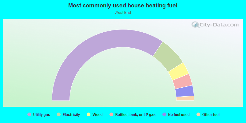
- 70.5%Utility gas
- 25.4%Electricity
- 2.5%No fuel used
- 1.6%Fuel oil, kerosene, etc.
Limited-access highways (interstate or state) in this neighborhood:
US Hwy 52 (I- 75)
Length: 0.46 miles
Directions: N-S, SE-NW
Directions: N-S, SE-NW
Highways in this neighborhood:
US Hwy 127 (Central Pkwy, US Hwy 27)
Length: 0.75 miles
Directions: N-S, SE-NW
Address range: 1000 to 2307
Directions: N-S, SE-NW
Address range: 1000 to 2307
US Hwy 27 (US Hwy 127, US Hwy 42, Plum St)
Length: 0.24 miles
Direction: N-S
Address range: 700 to 1099
Direction: N-S
Address range: 700 to 1099
Roads and streets:
Central Ave
Length: 1.77 miles
Directions: E-W, N-S, SE-NW
Address range: 700 to 2199
Directions: E-W, N-S, SE-NW
Address range: 700 to 2199
Winchell Ave
Length: 1.72 miles
Directions: E-W, N-S, SE-NW
Address range: 600 to 2199
Directions: E-W, N-S, SE-NW
Address range: 600 to 2199
W Liberty St
Length: 1.02 miles
Direction: E-W
Address range: 300 to 1099
Direction: E-W
Address range: 300 to 1099
Linn St
Length: 0.99 miles
Directions: N-S, SW-NE
Address range: 800 to 1999
Directions: N-S, SW-NE
Address range: 800 to 1999
John St
Length: 0.98 miles
Directions: E-W, N-S, SE-NW
Address range: 1000 to 1899
Directions: E-W, N-S, SE-NW
Address range: 1000 to 1899
Findlay St
Length: 0.95 miles
Directions: E-W, SW-NE
Address range: 300 to 1199
Directions: E-W, SW-NE
Address range: 300 to 1199
W Court St
Length: 0.85 miles
Directions: E-W, N-S, SE-NW, SW-NE
Address range: 300 to 1098
Directions: E-W, N-S, SE-NW, SW-NE
Address range: 300 to 1098
Ezzard Charles Dr
Length: 0.83 miles
Direction: E-W
Address range: 300 to 899
Direction: E-W
Address range: 300 to 899
Dayton St
Length: 0.75 miles
Directions: E-W, N-S, SW-NE
Address range: 400 to 1199
Directions: E-W, N-S, SW-NE
Address range: 400 to 1199
York St
Length: 0.72 miles
Directions: E-W, SE-NW
Address range: 400 to 1199
Directions: E-W, SE-NW
Address range: 400 to 1199
Poplar St
Length: 0.59 miles
Direction: E-W
Address range: 400 to 999
Direction: E-W
Address range: 400 to 999
Bank St
Length: 0.59 miles
Directions: E-W, SE-NW
Address range: 800 to 1199
Directions: E-W, SE-NW
Address range: 800 to 1199
Livingston St
Length: 0.58 miles
Directions: E-W, SE-NW
Address range: 400 to 999
Directions: E-W, SE-NW
Address range: 400 to 999
Charlotte St
Length: 0.56 miles
Direction: E-W
Address range: 300 to 999
Direction: E-W
Address range: 300 to 999
Laurel Park Dr
Length: 0.53 miles
Directions: E-W, N-S, SE-NW, SW-NE
Directions: E-W, N-S, SE-NW, SW-NE
Western Ave
Length: 0.52 miles
Directions: N-S, SE-NW
Address range: 1392 to 1853
Directions: N-S, SE-NW
Address range: 1392 to 1853
Clark St
Length: 0.51 miles
Directions: E-W, SE-NW
Address range: 400 to 999
Directions: E-W, SE-NW
Address range: 400 to 999
Naeher St
Length: 0.48 miles
Direction: E-W
Address range: 800 to 1199
Direction: E-W
Address range: 800 to 1199
Wade St
Length: 0.46 miles
Direction: E-W
Address range: 401 to 4634
Direction: E-W
Address range: 401 to 4634
Freeman Ave
Length: 0.46 miles
Directions: N-S, SE-NW
Address range: 1600 to 2199
Directions: N-S, SE-NW
Address range: 1600 to 2199
Cutter St
Length: 0.44 miles
Direction: N-S
Address range: 900 to 1199
Direction: N-S
Address range: 900 to 1199
Oliver St
Length: 0.43 miles
Direction: E-W
Address range: 300 to 599
Direction: E-W
Address range: 300 to 599
Colerain Ave
Length: 0.40 miles
Directions: N-S, SE-NW
Address range: 1900 to 2199
Directions: N-S, SE-NW
Address range: 1900 to 2199
Baymiller St
Length: 0.40 miles
Direction: N-S
Address range: 1600 to 2199
Direction: N-S
Address range: 1600 to 2199
Hopkins St
Length: 0.40 miles
Directions: E-W, SW-NE
Address range: 400 to 499
Directions: E-W, SW-NE
Address range: 400 to 499
W 8th St
Length: 0.39 miles
Directions: E-W, SE-NW
Address range: 300 to 599
Directions: E-W, SE-NW
Address range: 300 to 599
W 9th St
Length: 0.35 miles
Directions: E-W, SW-NE
Address range: 300 to 599
Directions: E-W, SW-NE
Address range: 300 to 599
Elizabeth St
Length: 0.35 miles
Direction: E-W
Address range: 400 to 599
Direction: E-W
Address range: 400 to 599
Chestnut St
Length: 0.33 miles
Direction: E-W
Address range: 400 to 599
Direction: E-W
Address range: 400 to 599
Derrick Turnbow Ave
Length: 0.33 miles
Direction: E-W
Address range: 400 to 831
Direction: E-W
Address range: 400 to 831
Providence St
Length: 0.31 miles
Direction: N-S
Address range: 1400 to 1699
Direction: N-S
Address range: 1400 to 1699
Horace St
Length: 0.31 miles
Direction: E-W
Address range: 400 to 899
Direction: E-W
Address range: 400 to 899
Mound St
Length: 0.27 miles
Direction: N-S
Address range: 800 to 1099
Direction: N-S
Address range: 800 to 1099
Richmond St
Length: 0.26 miles
Direction: E-W
Address range: 300 to 699
Direction: E-W
Address range: 300 to 699
Betton St
Length: 0.26 miles
Direction: E-W
Direction: E-W
Clayers Ln
Length: 0.24 miles
Directions: E-W, N-S, SE-NW
Directions: E-W, N-S, SE-NW
Bright Aly
Length: 0.24 miles
Directions: E-W, N-S
Address range: 1900 to 2171
Directions: E-W, N-S
Address range: 1900 to 2171
Wade Walk
Length: 0.23 miles
Direction: E-W
Address range: 800 to 899
Direction: E-W
Address range: 800 to 899
Bard Aly
Length: 0.22 miles
Directions: N-S, SE-NW, SW-NE
Address range: 1500 to 1725
Directions: N-S, SE-NW, SW-NE
Address range: 1500 to 1725
Clearwater St
Length: 0.22 miles
Direction: E-W
Address range: 800 to 999
Direction: E-W
Address range: 800 to 999
Pinecone Ln
Length: 0.21 miles
Directions: E-W, N-S, SW-NE
Directions: E-W, N-S, SW-NE
W 7th St
Length: 0.21 miles
Direction: E-W
Address range: 300 to 499
Direction: E-W
Address range: 300 to 499
Wilmink St
Length: 0.20 miles
Direction: E-W
Address range: 800 to 899
Direction: E-W
Address range: 800 to 899
Garden St
Length: 0.18 miles
Direction: E-W
Address range: 1000 to 1199
Direction: E-W
Address range: 1000 to 1199
David St
Length: 0.18 miles
Direction: E-W
Direction: E-W
Weninger Cir
Length: 0.18 miles
Directions: E-W, N-S, SE-NW
Directions: E-W, N-S, SE-NW
Beloit Aly
Length: 0.17 miles
Direction: E-W
Address range: 1000 to 1123
Direction: E-W
Address range: 1000 to 1123
Whiteman St
Length: 0.16 miles
Directions: E-W, N-S, SW-NE
Address range: 400 to 499
Directions: E-W, N-S, SW-NE
Address range: 400 to 499
Patterson St
Length: 0.16 miles
Direction: N-S
Address range: 2100 to 2199
Direction: N-S
Address range: 2100 to 2199
Harrison Ave
Length: 0.16 miles
Directions: E-W, SE-NW
Address range: 1100 to 1155
Directions: E-W, SE-NW
Address range: 1100 to 1155
Dalton Ave
Length: 0.15 miles
Direction: N-S
Address range: 1600 to 1799
Direction: N-S
Address range: 1600 to 1799
Weber Way
Length: 0.14 miles
Directions: E-W, N-S
Directions: E-W, N-S
Pink Aly
Length: 0.14 miles
Direction: N-S
Direction: N-S
Keywitt Aly
Length: 0.14 miles
Direction: N-S
Address range: 1800 to 1999
Direction: N-S
Address range: 1800 to 1999
Dudley Walk
Length: 0.14 miles
Directions: N-S, SE-NW
Address range: 1400 to 1599
Directions: N-S, SE-NW
Address range: 1400 to 1599
Kindel Ave
Length: 0.14 miles
Direction: N-S
Address range: 2100 to 2199
Direction: N-S
Address range: 2100 to 2199
Kossuth Ct
Length: 0.14 miles
Directions: E-W, N-S
Directions: E-W, N-S
Lupo Ct
Length: 0.14 miles
Directions: E-W, N-S
Directions: E-W, N-S
Baymiller Walk
Length: 0.13 miles
Direction: N-S
Address range: 1400 to 1699
Direction: N-S
Address range: 1400 to 1699
Essen Way
Length: 0.13 miles
Directions: E-W, N-S, SW-NE
Directions: E-W, N-S, SW-NE
8th Street Viaduct
Length: 0.13 miles
Direction: E-W
Direction: E-W
Andrew Aly
Length: 0.13 miles
Direction: N-S
Address range: 2100 to 2162
Direction: N-S
Address range: 2100 to 2162
Jones St
Length: 0.13 miles
Direction: N-S
Direction: N-S
Munchen Way
Length: 0.12 miles
Directions: E-W, N-S, SE-NW
Directions: E-W, N-S, SE-NW
Hulbert Ave
Length: 0.12 miles
Direction: E-W
Address range: 1000 to 1099
Direction: E-W
Address range: 1000 to 1099
Spanner Dr
Length: 0.12 miles
Directions: E-W, N-S, SE-NW, SW-NE
Directions: E-W, N-S, SE-NW, SW-NE
Bauer Ave
Length: 0.11 miles
Direction: E-W
Address range: 400 to 499
Direction: E-W
Address range: 400 to 499
Kimpell Aly
Length: 0.11 miles
Direction: N-S
Address range: 2100 to 2199
Direction: N-S
Address range: 2100 to 2199
W 14th St
Length: 0.11 miles
Direction: E-W
Address range: 300 to 399
Direction: E-W
Address range: 300 to 399
Charles St
Length: 0.11 miles
Direction: E-W
Address range: 300 to 399
Direction: E-W
Address range: 300 to 399
W 12th St
Length: 0.11 miles
Direction: E-W
Address range: 300 to 399
Direction: E-W
Address range: 300 to 399
W 15th St
Length: 0.11 miles
Directions: E-W, SW-NE
Address range: 300 to 399
Directions: E-W, SW-NE
Address range: 300 to 399
Fugate Aly
Length: 0.11 miles
Directions: E-W, SE-NW
Directions: E-W, SE-NW
Old Court St
Length: 0.10 miles
Direction: E-W
Address range: 400 to 499
Direction: E-W
Address range: 400 to 499
Laurel Park Dr (Genessee St)
Length: 0.10 miles
Directions: E-W, SW-NE
Directions: E-W, SW-NE
Synder Aly
Length: 0.10 miles
Direction: N-S
Direction: N-S
Near Dr
Length: 0.09 miles
Directions: E-W, SE-NW
Directions: E-W, SE-NW
Corn Aly
Length: 0.09 miles
Direction: E-W
Direction: E-W
Rittehouse Ct
Length: 0.09 miles
Direction: E-W
Direction: E-W
Kuners Aly
Length: 0.09 miles
Direction: N-S
Address range: 1600 to 1657
Direction: N-S
Address range: 1600 to 1657
Kuhfers Aly
Length: 0.09 miles
Directions: N-S, SE-NW
Address range: 1700 to 1725
Directions: N-S, SE-NW
Address range: 1700 to 1725
Koebel St
Length: 0.09 miles
Direction: N-S
Address range: 2100 to 2199
Direction: N-S
Address range: 2100 to 2199
Kenner St
Length: 0.09 miles
Direction: E-W
Address range: 1000 to 1099
Direction: E-W
Address range: 1000 to 1099
Eve Aly
Length: 0.09 miles
Direction: E-W
Address range: 520 to 599
Direction: E-W
Address range: 520 to 599
Currey Aly
Length: 0.08 miles
Direction: E-W
Address range: 1106 to 1199
Direction: E-W
Address range: 1106 to 1199
Lockhurst Ln
Length: 0.08 miles
Directions: N-S, SE-NW
Address range: 1600 to 1699
Directions: N-S, SE-NW
Address range: 1600 to 1699
Helgolander Way
Length: 0.08 miles
Directions: E-W, N-S, SW-NE
Directions: E-W, N-S, SW-NE
Lowe Dr
Length: 0.08 miles
Direction: E-W
Direction: E-W
Mohawk Pl
Length: 0.08 miles
Direction: SW-NE
Direction: SW-NE
Wesley Ave
Length: 0.08 miles
Direction: N-S
Address range: 1000 to 1099
Direction: N-S
Address range: 1000 to 1099
Ashton Aly
Length: 0.07 miles
Direction: E-W
Direction: E-W
Tiernan Aly
Length: 0.07 miles
Directions: N-S, SE-NW
Address range: 312 to 333
Directions: N-S, SE-NW
Address range: 312 to 333
Denman St
Length: 0.07 miles
Direction: N-S
Address range: 1400 to 1449
Direction: N-S
Address range: 1400 to 1449
Barton Dr
Length: 0.06 miles
Direction: E-W
Direction: E-W
Genevaview St
Length: 0.06 miles
Directions: E-W, SE-NW
Directions: E-W, SE-NW
Milo Aly
Length: 0.06 miles
Direction: N-S
Direction: N-S
Peru Dr
Length: 0.06 miles
Direction: E-W
Direction: E-W
Luke Dr
Length: 0.06 miles
Direction: E-W
Direction: E-W
Brighton Brg (Brighton Bridge Approach)
Length: 0.06 miles
Directions: N-S, SE-NW
Directions: N-S, SE-NW
Bent Dr
Length: 0.06 miles
Direction: E-W
Direction: E-W
Galena Aly
Length: 0.06 miles
Direction: E-W
Address range: 300 to 312
Direction: E-W
Address range: 300 to 312
Malden Walk
Length: 0.06 miles
Direction: N-S
Address range: 1600 to 1699
Direction: N-S
Address range: 1600 to 1699
Partridge Pl
Length: 0.06 miles
Direction: N-S
Address range: 2100 to 2199
Direction: N-S
Address range: 2100 to 2199
Isaac Aly
Length: 0.06 miles
Direction: E-W
Address range: 400 to 499
Direction: E-W
Address range: 400 to 499
Hulse Dr
Length: 0.05 miles
Direction: E-W
Direction: E-W
Snyder Aly
Length: 0.05 miles
Direction: N-S
Address range: 1813 to 1825
Direction: N-S
Address range: 1813 to 1825
Rhine Way
Length: 0.05 miles
Direction: N-S
Direction: N-S
Ruhr Way
Length: 0.05 miles
Direction: N-S
Direction: N-S
Truman Aly
Length: 0.05 miles
Direction: N-S
Address range: 1200 to 1227
Direction: N-S
Address range: 1200 to 1227
Findlay Ct
Length: 0.05 miles
Direction: E-W
Address range: 1020 to 1051
Direction: E-W
Address range: 1020 to 1051
Gibson Aly
Length: 0.05 miles
Direction: N-S
Address range: 2010 to 2025
Direction: N-S
Address range: 2010 to 2025
Porter
Length: 0.05 miles
Direction: N-S
Address range: 2000 to 2025
Direction: N-S
Address range: 2000 to 2025
Runfers Aly
Length: 0.04 miles
Directions: N-S, SE-NW
Directions: N-S, SE-NW
Kufhers Aly
Length: 0.04 miles
Direction: N-S
Direction: N-S
Xavier Aly
Length: 0.04 miles
Directions: E-W, SE-NW
Address range: 508 to 525
Directions: E-W, SE-NW
Address range: 508 to 525
Nome Aly
Length: 0.04 miles
Direction: N-S
Direction: N-S
Werner St
Length: 0.04 miles
Direction: N-S
Address range: 1716 to 1799
Direction: N-S
Address range: 1716 to 1799
Bauman St
Length: 0.04 miles
Direction: N-S
Address range: 1718 to 1799
Direction: N-S
Address range: 1718 to 1799
Acme Aly
Length: 0.04 miles
Direction: N-S
Direction: N-S
Gay Aly
Length: 0.04 miles
Direction: N-S
Direction: N-S
Peale Aly
Length: 0.03 miles
Direction: N-S
Direction: N-S
Kimpel Aly
Length: 0.03 miles
Direction: N-S
Direction: N-S
Lloyd Aly
Length: 0.03 miles
Direction: N-S
Direction: N-S
A Ln
Length: 0.03 miles
Direction: N-S
Direction: N-S
Lurch Aly
Length: 0.03 miles
Direction: E-W
Direction: E-W
Brighton Pl
Length: 0.03 miles
Direction: SW-NE
Direction: SW-NE
Brighton Bridge Approach
Length: 0.03 miles
Direction: N-S
Direction: N-S
Goodin Aly
Length: 0.03 miles
Direction: SE-NW
Direction: SE-NW
Brighton Ln
Length: 0.02 miles
Direction: N-S
Direction: N-S