West Side (the West Side) neighborhood in Leominster, Massachusetts (MA), 01453 detailed profile
Settings
X


Business Search - 14 Million verified businesses
Area: 2.833 square miles
Population: 8,127
Population density:
| West Side (the West Side): | 2,868 people per square mile |
| Leominster: | 1,511 people per square mile |

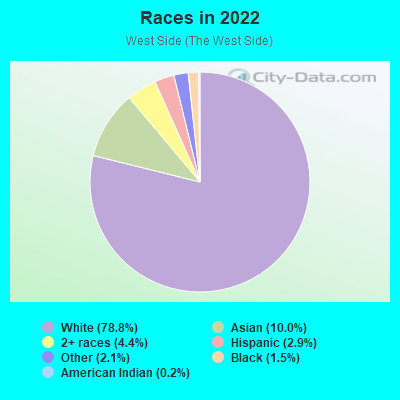
- 5,74565.0%White
- 1,61118.2%Hispanic or Latino
- 5526.2%Black
- 3233.7%Two or more races
- 3123.5%American Indian
- 2092.4%Asian
- 881.0%Some other race
Distribution of median household income
![Distribution of median household income]()
- 231Less than $10,000
- 469$10,000 to $19,999
- 306$20,000 to $29,999
- 740$30,000 to $39,999
- 310$40,000 to $49,999
- 412$50,000 to $59,999
- 383$60,000 to $74,999
- 434$75,000 to $99,999
- 575$100,000 to $124,999
- 370$125,000 to $149,999
- 284$150,000 to $199,999
- 284$200,000 or more

Distribution of owner-occupied house/condo value
![Distribution of owner-occupied house/condo value]()
- 342Less than $50,000
- 31$50,000 to $99,999
- 261$100,000 to $149,999
- 531$150,000 to $199,999
- 276$200,000 to $249,999
- 314$250,000 to $299,999
- 1,038$300,000 to $399,999
- 321$400,000 to $499,999
- 127$500,000 to $749,999
- 97$750,000 to $999,999
- 16$1,000,000 or more

Distribution of rent paid by renters
![Distribution of rent paid by renters]()
- 449$100 to $199
- 331$200 to $299
- 581$300 to $399
- 446$400 to $499
- 470$500 to $599
- 271$600 to $699
- 850$700 to $799
- 383$800 to $899
- 310$900 to $999
- 471$1,000 to $1,249
- 489$1,250 to $1,499
- 211$1,500 to $1,999
- 282$2,000 or more

| Males: | 4,061 |
| Females: | 4,065 |
Males:
| This neighborhood: | 41.7 years |
| Whole city: | 40.0 years |
| This neighborhood: | 48.0 years |
| Whole city: | 46.5 years |
Average household size:
| West Side (the West Side): | 6.6 people |
| Leominster: | 2.3 people |
Percentage of family households:
| West Side (the West Side): | 39.9% |
| Leominster: | 44.1% |
| Here: | 39.8% |
| Leominster: | 41.9% |
Percentage of married-couple families with children (among all households):
| West Side (the West Side): | 39.9% |
| Leominster: | 28.9% |
Percentage of single-mother households (among all households):
| West Side (the West Side): | 7.5% |
| Leominster: | 9.6% |
Percentage of never married males 15 years old and over:
Percentage of never married females 15 years old and over:
| West Side (the West Side): | 21.7% |
| Leominster: | 19.7% |
Percentage of never married females 15 years old and over:
| West Side (the West Side): | 13.1% |
| city: | 13.6% |
Percentage of people that speak English not well or not at all:
| West Side (the West Side): | 4.5% |
| Leominster: | 3.7% |
Percentage of people born in this state:
Percentage of people born in another U.S. state:
Percentage of native residents but born outside the U.S.:
Percentage of foreign born residents:
| Here: | 65.0% |
| Leominster: | 66.2% |
Percentage of people born in another U.S. state:
| West Side (the West Side): | 21.7% |
| Leominster: | 15.9% |
Percentage of native residents but born outside the U.S.:
| Here: | 2.7% |
| city: | 3.2% |
Percentage of foreign born residents:
| Here: | 10.7% |
| Leominster: | 14.7% |
Owner-occupied
Renter-occupied

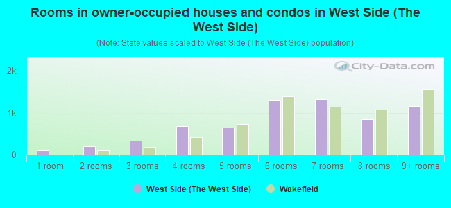
- Rooms in owner-occupied houses and condos in West Side <
> - 01 room
- 192 rooms
- 353 rooms
- 2884 rooms
- 3155 rooms
- 6836 rooms
- 2697 rooms
- 3998 rooms
- 4019+ rooms
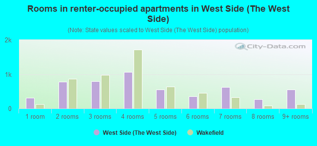
- Rooms in renter-occupied apartments in West Side <
> - 2281 room
- 2982 rooms
- 4933 rooms
- 4584 rooms
- 5085 rooms
- 2916 rooms
- 1037 rooms
- 488 rooms
- 7859+ rooms
Owner-occupied
Renter-occupied
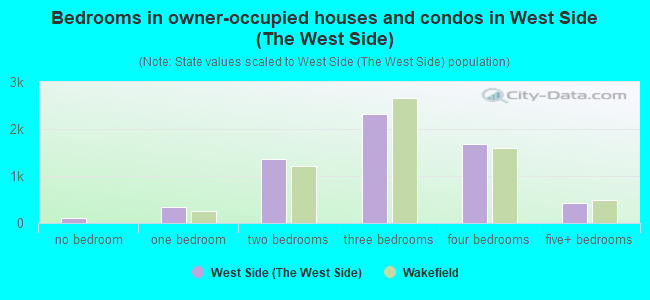
- Bedrooms in owner-occupied houses and condos in West Side <
> - 19no bedroom
- 2541 bedroom
- 5542 bedrooms
- 1,0303 bedrooms
- 4144 bedrooms
- 1925+ bedrooms
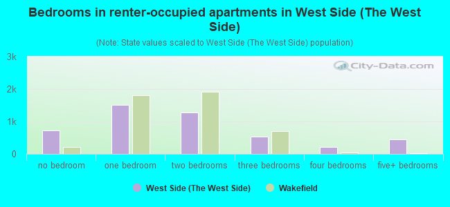
- Bedrooms in renter-occupied apartments in West Side <
> - 228no bedroom
- 7671 bedroom
- 5912 bedrooms
- 2123 bedrooms
- 2994 bedrooms
- 05+ bedrooms
Average number of cars or other vehicles available in houses/condos:
Average number of cars or other vehicles available in apartments:
| This neighborhood: | 2.6 |
| Leominster: | 2.0 |
Average number of cars or other vehicles available in apartments:
| Here: | 1.7 |
| city: | 1.1 |
Percentage of units with a mortgage:
| West Side (the West Side): | 69.8% |
| Leominster: | 66.8% |
Average estimated value of detached houses in 2022 (51.8% of all units):
| West Side (the West Side): | $309,500 |
| Leominster: | $356,356 |
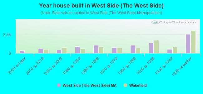
- Year house built in West Side <
> - 162020 or later
- 1912010 to 2019
- 1252000 to 2009
- 1791990 to 1999
- 2031980 to 1989
- 5281970 to 1979
- 5221960 to 1969
- 8021950 to 1959
- 4371940 to 1949
- 1,3121939 or earlier
City-data.com crime index for city in 2020 (higher means more crime):
| City: | 215.0 |
| U.S. average: | 219.5 |
Travel time to work (commute)
![Travel time to work (commute)]()
- 81Less than 5 minutes
- 4065 to 9 minutes
- 73010 to 14 minutes
- 31015 to 19 minutes
- 51120 to 24 minutes
- 15225 to 29 minutes
- 49630 to 34 minutes
- 10135 to 39 minutes
- 21840 to 44 minutes
- 39745 to 59 minutes
- 37760 to 89 minutes
- 25890 or more minutes

Means of transportation to work
![Means of transportation to work]()
- 79.8%3,666Drove a car alone
- 5.3%245Carpooled
- 10.9%499Bus
- 20.1%922Subway or elevated rail
- 1.2%55Long-distance train or commuter rail
- 4.4%201Bicycle
- 4.4%200Walked
- 3.5%161Other means
- 9.4%430Worked at home

Time leaving home to go to work
![Time leaving home to go to work]()
- 13312:00 a.m. to 4:59 a.m.
- 1245:00 a.m. to 5:29 a.m.
- 2295:30 a.m. to 5:59 a.m.
- 2516:00 a.m. to 6:29 a.m.
- 7146:30 a.m. to 6:59 a.m.
- 6377:00 a.m. to 7:29 a.m.
- 5577:30 a.m. to 7:59 a.m.
- 3648:00 a.m. to 8:29 a.m.
- 1368:30 a.m. to 8:59 a.m.
- 3099:00 a.m. to 9:59 a.m.
- 10110:00 a.m. to 10:59 a.m.
- 1611:00 a.m. to 11:59 a.m.
- 22012:00 p.m. to 3:59 p.m.
- 2944:00 p.m. to 11:59 p.m.

Occupations of males:
- Percentage of males in management occupations (except farmers):
Here: 12.3% city: 12.2%
- Percentage of males in business and financial operations occupations:
Here: 3.6% city: 5.8%
- Percentage of males in computer and mathematical occupations:
Here: 8.2% city: 5.8%
- Percentage of males in architecture and engineering occupations:
Here: 4.4% city: 4.1%
- Percentage of males in life, physical, and social science occupations:
Here: 1.0% city: 1.2%
- Percentage of males in education, training, and library occupations:
Here: 4.3% city: 2.7%
- Percentage of males in arts, design, entertainment, sports, and media occupations:
Here: 3.6% city: 2.7%
- Percentage of males in healthcare practitioners and technical occupations:
Here: 2.3% city: 2.8%
- Percentage of males in service occupations:
Here: 11.7% city: 12.1%
- Percentage of males in sales and office occupations:
Here: 13.3% city: 13.8%
- Percentage of males in farming, fishing, and forestry occupations:
Here: 1.3% city: 0.4%
- Percentage of males in construction, extraction, and maintenance occupations:
Here: 7.7% city: 5.9%
- Percentage of males in production occupations:
Here: 8.2% city: 7.8%
- Percentage of males in transportation occupations:
Here: 5.5% city: 8.2%
- Percentage of males in material moving occupations:
Here: 7.4% city: 7.3%
Occupations of females:
- Percentage of females in management occupations (except farmers):
Here: 7.1% city: 7.4%
- Percentage of females in business and financial operations occupations:
Here: 6.5% city: 5.1%
- Percentage of females in computer and mathematical occupations:
Here: 1.1% city: 1.4%
- Percentage of females in architecture and engineering occupations:
Here: 1.3% city: 1.2%
- Percentage of females in life, physical, and social science occupations:
Here: 1.5% city: 1.3%
- Percentage of females in legal occupations:
Here: 1.1% city: 1.2%
- Percentage of females in education, training, and library occupations:
Here: 15.2% city: 11.1%
- Percentage of females in healthcare practitioners and technical occupations:
Here: 13.5% city: 10.4%
- Percentage of females in service occupations:
Here: 17.0% city: 23.0%
- Percentage of females in sales and office occupations:
Here: 30.1% city: 24.1%
- Percentage of females in farming, fishing, and forestry occupations:
Here: 1.0% city: 0.8%
- Percentage of females in material moving occupations:
Here: 2.1% city: 2.2%
Percentage of people 16-64 in Armed Forces:
| West Side (the West Side): | 1.0% |
| Leominster: | 0.3% |
Education in this neighborhood (subdivision or community):
- Percentage of people 3 years and older in K-12 schools:
West Side (the West Side): 19.2% Leominster: 14.2%
- Percentage of people 3 years and older in undergraduate colleges:
West Side (the West Side): 6.2% Leominster: 3.6%
- Percentage of people 3 years and older in grad. or professional schools:
West Side (the West Side): 2.7% Leominster: 1.3%
- Percentage of students K-12 enrolled in private schools:
West Side (the West Side): 27.6% Leominster: 9.7%
Percentage of population below poverty level:
| West Side (the West Side): | 6.5% |
| Leominster: | 9.1% |
Median year owner moved in (as recorded in 2022):
| West Side (the West Side): | 2004 |
| Leominster: | 2005 |
Percentage of married-couple families with both working:
| West Side (the West Side): | 70.9% |
| Leominster: | 75.1% |
- 35.9%Fuel oil, kerosene, etc.
- 32.7%Utility gas
- 15.2%Electricity
- 7.0%Wood
- 3.3%No fuel used
- 3.0%Bottled, tank, or LP gas
- 2.9%Other fuel
Highways in this neighborhood:
N Main St (State Hwy 12)
Length: 1.35 miles
Directions: N-S, SE-NW
Address range: 1 to 452
Directions: N-S, SE-NW
Address range: 1 to 452
George W Stanton Hwy (Mass State Hwy, State Hwy 2)
Length: 0.41 miles
Directions: E-W, SE-NW
Directions: E-W, SE-NW
Main St (State Hwy 13)
Length: 0.27 miles
Directions: E-W, N-S, SW-NE
Address range: 100 to 189
Directions: E-W, N-S, SW-NE
Address range: 100 to 189
Central St (State Hwy 12)
Length: 0.10 miles
Directions: N-S, SE-NW
Address range: 4 to 47
Directions: N-S, SE-NW
Address range: 4 to 47
State Hwy 12 (Monument Sq)
Length: 0.07 miles
Directions: N-S, SE-NW
Address range: 1 to 99
Directions: N-S, SE-NW
Address range: 1 to 99
Roads and streets:
West St
Length: 2.89 miles
Directions: E-W, N-S, SE-NW
Address range: 25 to 950
Directions: E-W, N-S, SE-NW
Address range: 25 to 950
Merriam Ave
Length: 2.26 miles
Directions: E-W, N-S, SE-NW
Address range: 73 to 807
Directions: E-W, N-S, SE-NW
Address range: 73 to 807
Lindell Ave
Length: 1.83 miles
Directions: E-W, SE-NW, SW-NE
Address range: 1 to 563
Directions: E-W, SE-NW, SW-NE
Address range: 1 to 563
Abbott Ave
Length: 1.08 miles
Directions: N-S, SE-NW
Address range: 1 to 452
Directions: N-S, SE-NW
Address range: 1 to 452
Washington St
Length: 0.88 miles
Directions: N-S, SW-NE
Address range: 1 to 299
Directions: N-S, SW-NE
Address range: 1 to 299
Highland Ave
Length: 0.86 miles
Directions: N-S, SE-NW
Address range: 1 to 316
Directions: N-S, SE-NW
Address range: 1 to 316
Grove Ave
Length: 0.76 miles
Directions: N-S, SE-NW
Address range: 1 to 299
Directions: N-S, SE-NW
Address range: 1 to 299
Pleasant St
Length: 0.75 miles
Directions: E-W, SW-NE
Address range: 1 to 230
Directions: E-W, SW-NE
Address range: 1 to 230
Walnut St
Length: 0.73 miles
Direction: E-W
Address range: 1 to 199
Direction: E-W
Address range: 1 to 199
Arlington St
Length: 0.67 miles
Directions: N-S, SW-NE
Address range: 1 to 244
Directions: N-S, SW-NE
Address range: 1 to 244
Hall St
Length: 0.65 miles
Directions: N-S, SW-NE
Address range: 1 to 299
Directions: N-S, SW-NE
Address range: 1 to 299
Granite St
Length: 0.62 miles
Directions: E-W, SE-NW, SW-NE
Address range: 1 to 171
Directions: E-W, SE-NW, SW-NE
Address range: 1 to 171
Olde Tavern Rd
Length: 0.62 miles
Directions: E-W, N-S, SE-NW, SW-NE
Address range: 1 to 199
Directions: E-W, N-S, SE-NW, SW-NE
Address range: 1 to 199
Pond St
Length: 0.61 miles
Directions: E-W, N-S, SE-NW, SW-NE
Address range: 1 to 199
Directions: E-W, N-S, SE-NW, SW-NE
Address range: 1 to 199
Willow St
Length: 0.58 miles
Directions: E-W, N-S, SE-NW
Address range: 1 to 199
Directions: E-W, N-S, SE-NW
Address range: 1 to 199
Cumberland Rd
Length: 0.56 miles
Directions: E-W, N-S, SE-NW, SW-NE
Address range: 1 to 151
Directions: E-W, N-S, SE-NW, SW-NE
Address range: 1 to 151
Country Ln
Length: 0.52 miles
Directions: N-S, SE-NW
Address range: 1 to 199
Directions: N-S, SE-NW
Address range: 1 to 199
Blossom St
Length: 0.52 miles
Direction: SW-NE
Address range: 1 to 199
Direction: SW-NE
Address range: 1 to 199
High St
Length: 0.51 miles
Direction: E-W
Address range: 1 to 199
Direction: E-W
Address range: 1 to 199
Kingman Dr
Length: 0.50 miles
Directions: N-S, SE-NW
Directions: N-S, SE-NW
Nelson St
Length: 0.49 miles
Direction: E-W
Address range: 1 to 199
Direction: E-W
Address range: 1 to 199
Helena St
Length: 0.48 miles
Directions: N-S, SE-NW
Address range: 1 to 233
Directions: N-S, SE-NW
Address range: 1 to 233
Exchange St
Length: 0.47 miles
Directions: E-W, SW-NE
Address range: 1 to 196
Directions: E-W, SW-NE
Address range: 1 to 196
Smith St
Length: 0.43 miles
Directions: N-S, SE-NW
Address range: 1 to 199
Directions: N-S, SE-NW
Address range: 1 to 199
Cottage St
Length: 0.42 miles
Directions: E-W, SE-NW, SW-NE
Address range: 1 to 139
Directions: E-W, SE-NW, SW-NE
Address range: 1 to 139
Adams St
Length: 0.40 miles
Direction: SE-NW
Address range: 66 to 199
Direction: SE-NW
Address range: 66 to 199
Maple Ave
Length: 0.39 miles
Directions: N-S, SE-NW
Address range: 1 to 151
Directions: N-S, SE-NW
Address range: 1 to 151
Kendall Hill Rd
Length: 0.37 miles
Directions: N-S, SW-NE
Address range: 1 to 99
Directions: N-S, SW-NE
Address range: 1 to 99
Boutelle St
Length: 0.35 miles
Directions: E-W, SE-NW, SW-NE
Address range: 1 to 118
Directions: E-W, SE-NW, SW-NE
Address range: 1 to 118
Winter St
Length: 0.35 miles
Direction: N-S
Address range: 1 to 199
Direction: N-S
Address range: 1 to 199
Hospital Rd
Length: 0.34 miles
Directions: E-W, N-S, SE-NW, SW-NE
Address range: 1 to 199
Directions: E-W, N-S, SE-NW, SW-NE
Address range: 1 to 199
Posco Ave
Length: 0.34 miles
Directions: E-W, N-S, SE-NW
Address range: 1 to 111
Directions: E-W, N-S, SE-NW
Address range: 1 to 111
Palm St
Length: 0.33 miles
Directions: E-W, SE-NW
Address range: 1 to 99
Directions: E-W, SE-NW
Address range: 1 to 99
Austin St
Length: 0.33 miles
Direction: E-W
Address range: 1 to 99
Direction: E-W
Address range: 1 to 99
Hillery Rd
Length: 0.32 miles
Directions: E-W, N-S, SE-NW, SW-NE
Address range: 1 to 98
Directions: E-W, N-S, SE-NW, SW-NE
Address range: 1 to 98
Dillon St
Length: 0.32 miles
Direction: E-W
Address range: 1 to 99
Direction: E-W
Address range: 1 to 99
Orchard St
Length: 0.32 miles
Direction: SW-NE
Address range: 1 to 99
Direction: SW-NE
Address range: 1 to 99
Crestfield Ln
Length: 0.28 miles
Directions: E-W, SE-NW
Address range: 19 to 77
Directions: E-W, SE-NW
Address range: 19 to 77
Stearns Ave
Length: 0.27 miles
Direction: E-W
Address range: 1 to 99
Direction: E-W
Address range: 1 to 99
Cotton St
Length: 0.25 miles
Direction: SW-NE
Address range: 1 to 99
Direction: SW-NE
Address range: 1 to 99
Vine St
Length: 0.25 miles
Directions: N-S, SW-NE
Address range: 1 to 99
Directions: N-S, SW-NE
Address range: 1 to 99
Fairfield Rd
Length: 0.24 miles
Direction: SW-NE
Address range: 1 to 100
Direction: SW-NE
Address range: 1 to 100
Newton St
Length: 0.24 miles
Directions: E-W, SE-NW
Address range: 1 to 99
Directions: E-W, SE-NW
Address range: 1 to 99
Chestnut St
Length: 0.23 miles
Direction: E-W
Address range: 1 to 72
Direction: E-W
Address range: 1 to 72
Pearl St
Length: 0.23 miles
Direction: E-W
Address range: 1 to 99
Direction: E-W
Address range: 1 to 99
Richardson St
Length: 0.23 miles
Direction: E-W
Address range: 1 to 99
Direction: E-W
Address range: 1 to 99
George Ter
Length: 0.23 miles
Directions: E-W, N-S, SE-NW, SW-NE
Address range: 1 to 99
Directions: E-W, N-S, SE-NW, SW-NE
Address range: 1 to 99
Church St
Length: 0.23 miles
Directions: N-S, SW-NE
Address range: 1 to 99
Directions: N-S, SW-NE
Address range: 1 to 99
George St
Length: 0.22 miles
Directions: E-W, SE-NW
Address range: 1 to 99
Directions: E-W, SE-NW
Address range: 1 to 99
St Jean Ave
Length: 0.21 miles
Direction: N-S
Address range: 1 to 99
Direction: N-S
Address range: 1 to 99
Fruit St
Length: 0.21 miles
Directions: E-W, SE-NW
Address range: 1 to 99
Directions: E-W, SE-NW
Address range: 1 to 99
View St
Length: 0.20 miles
Direction: SE-NW
Address range: 15 to 98
Direction: SE-NW
Address range: 15 to 98
Rustic Dr
Length: 0.20 miles
Direction: E-W
Address range: 1 to 99
Direction: E-W
Address range: 1 to 99
Betanray Ct
Length: 0.20 miles
Directions: E-W, N-S, SW-NE
Address range: 1 to 99
Directions: E-W, N-S, SW-NE
Address range: 1 to 99
Thayer St
Length: 0.20 miles
Directions: E-W, N-S, SW-NE
Address range: 1 to 99
Directions: E-W, N-S, SW-NE
Address range: 1 to 99
Bartlett St
Length: 0.20 miles
Directions: E-W, SE-NW
Address range: 1 to 99
Directions: E-W, SE-NW
Address range: 1 to 99
Daley St
Length: 0.19 miles
Directions: N-S, SE-NW
Address range: 1 to 99
Directions: N-S, SE-NW
Address range: 1 to 99
Hale St
Length: 0.19 miles
Direction: SW-NE
Address range: 1 to 99
Direction: SW-NE
Address range: 1 to 99
Barrett Pkwy
Length: 0.19 miles
Directions: E-W, N-S, SE-NW, SW-NE
Address range: 1 to 99
Directions: E-W, N-S, SE-NW, SW-NE
Address range: 1 to 99
Grandview Ave
Length: 0.19 miles
Direction: SW-NE
Address range: 1 to 99
Direction: SW-NE
Address range: 1 to 99
Campbell Ave
Length: 0.18 miles
Direction: E-W
Address range: 1 to 99
Direction: E-W
Address range: 1 to 99
Hawley Ave
Length: 0.18 miles
Directions: E-W, N-S, SE-NW
Address range: 1 to 99
Directions: E-W, N-S, SE-NW
Address range: 1 to 99
Dimassa Dr
Length: 0.18 miles
Directions: E-W, N-S, SE-NW, SW-NE
Address range: 1 to 68
Directions: E-W, N-S, SE-NW, SW-NE
Address range: 1 to 68
Shadow Lawn Dr
Length: 0.17 miles
Direction: E-W
Address range: 1 to 99
Direction: E-W
Address range: 1 to 99
Grove Ter
Length: 0.17 miles
Direction: E-W
Address range: 1 to 49
Direction: E-W
Address range: 1 to 49
Merritt St
Length: 0.16 miles
Direction: SW-NE
Address range: 1 to 99
Direction: SW-NE
Address range: 1 to 99
Myrtle St
Length: 0.16 miles
Direction: E-W
Address range: 1 to 99
Direction: E-W
Address range: 1 to 99
Laurie Dr
Length: 0.16 miles
Directions: N-S, SE-NW
Address range: 1 to 55
Directions: N-S, SE-NW
Address range: 1 to 55
Mc Kay St
Length: 0.16 miles
Direction: E-W
Address range: 1 to 99
Direction: E-W
Address range: 1 to 99
Harwood Ter
Length: 0.15 miles
Directions: E-W, N-S, SE-NW, SW-NE
Address range: 1 to 99
Directions: E-W, N-S, SE-NW, SW-NE
Address range: 1 to 99
Notre Dame
Length: 0.15 miles
Direction: E-W
Address range: 1 to 99
Direction: E-W
Address range: 1 to 99
Clark St
Length: 0.15 miles
Direction: E-W
Address range: 1 to 99
Direction: E-W
Address range: 1 to 99
Amanda Ct
Length: 0.15 miles
Direction: E-W
Address range: 1 to 99
Direction: E-W
Address range: 1 to 99
Hammond St
Length: 0.15 miles
Directions: E-W, SW-NE
Address range: 1 to 47
Directions: E-W, SW-NE
Address range: 1 to 47
Doyle St
Length: 0.15 miles
Direction: E-W
Address range: 1 to 99
Direction: E-W
Address range: 1 to 99
Merriam Pkwy
Length: 0.15 miles
Directions: E-W, N-S, SW-NE
Address range: 1 to 99
Directions: E-W, N-S, SW-NE
Address range: 1 to 99
S Cotton St
Length: 0.15 miles
Direction: N-S
Address range: 1 to 99
Direction: N-S
Address range: 1 to 99
Salisbury St
Length: 0.14 miles
Direction: E-W
Address range: 1 to 99
Direction: E-W
Address range: 1 to 99
Aloe Dr
Length: 0.14 miles
Directions: E-W, SE-NW
Address range: 1 to 99
Directions: E-W, SE-NW
Address range: 1 to 99
Orchard Ter
Length: 0.14 miles
Directions: N-S, SE-NW
Address range: 1 to 50
Directions: N-S, SE-NW
Address range: 1 to 50
Cherry St
Length: 0.14 miles
Direction: SW-NE
Address range: 1 to 99
Direction: SW-NE
Address range: 1 to 99
Iliad St
Length: 0.14 miles
Direction: SW-NE
Address range: 1 to 99
Direction: SW-NE
Address range: 1 to 99
Haynes Ct
Length: 0.14 miles
Direction: SW-NE
Address range: 1 to 99
Direction: SW-NE
Address range: 1 to 99
Roche Ave (Roache St)
Length: 0.13 miles
Direction: E-W
Address range: 1 to 99
Direction: E-W
Address range: 1 to 99
Belmont Rd
Length: 0.13 miles
Direction: N-S
Address range: 1 to 99
Direction: N-S
Address range: 1 to 99
Campobasso Ln
Length: 0.13 miles
Directions: N-S, SE-NW
Address range: 1 to 99
Directions: N-S, SE-NW
Address range: 1 to 99
Coolidge St
Length: 0.13 miles
Direction: E-W
Address range: 1 to 99
Direction: E-W
Address range: 1 to 99
Park St
Length: 0.13 miles
Direction: SE-NW
Direction: SE-NW
Berkshire Dr
Length: 0.13 miles
Directions: E-W, SE-NW, SW-NE
Address range: 1 to 99
Directions: E-W, SE-NW, SW-NE
Address range: 1 to 99
Gibson St
Length: 0.13 miles
Direction: E-W
Address range: 1 to 99
Direction: E-W
Address range: 1 to 99
University St
Length: 0.12 miles
Direction: E-W
Address range: 1 to 99
Direction: E-W
Address range: 1 to 99
Walcott St
Length: 0.12 miles
Direction: E-W
Address range: 1 to 50
Direction: E-W
Address range: 1 to 50
Norfolk Dr
Length: 0.12 miles
Directions: E-W, SE-NW, SW-NE
Address range: 1 to 50
Directions: E-W, SE-NW, SW-NE
Address range: 1 to 50
Field Rd
Length: 0.12 miles
Directions: E-W, SW-NE
Address range: 1 to 99
Directions: E-W, SW-NE
Address range: 1 to 99
School St
Length: 0.12 miles
Direction: N-S
Address range: 1 to 99
Direction: N-S
Address range: 1 to 99
Lily Dr
Length: 0.11 miles
Directions: E-W, N-S
Address range: 1 to 51
Directions: E-W, N-S
Address range: 1 to 51
Bowen Pl
Length: 0.11 miles
Directions: N-S, SW-NE
Address range: 1 to 99
Directions: N-S, SW-NE
Address range: 1 to 99
Madison St
Length: 0.11 miles
Directions: E-W, N-S, SE-NW, SW-NE
Address range: 1 to 99
Directions: E-W, N-S, SE-NW, SW-NE
Address range: 1 to 99
Brentwood Dr
Length: 0.11 miles
Directions: E-W, SW-NE
Address range: 1 to 32
Directions: E-W, SW-NE
Address range: 1 to 32
Academy Rd
Length: 0.11 miles
Directions: N-S, SE-NW
Address range: 1 to 99
Directions: N-S, SE-NW
Address range: 1 to 99
Parker Rd
Length: 0.11 miles
Directions: E-W, N-S, SE-NW
Address range: 1 to 29
Directions: E-W, N-S, SE-NW
Address range: 1 to 29
Dartmouth St
Length: 0.10 miles
Direction: E-W
Address range: 1 to 99
Direction: E-W
Address range: 1 to 99
Porter St
Length: 0.10 miles
Directions: E-W, N-S, SW-NE
Address range: 1 to 35
Directions: E-W, N-S, SW-NE
Address range: 1 to 35
Monroe St
Length: 0.10 miles
Direction: SE-NW
Address range: 1 to 99
Direction: SE-NW
Address range: 1 to 99
Gustavus St
Length: 0.10 miles
Direction: SE-NW
Address range: 1 to 99
Direction: SE-NW
Address range: 1 to 99
Houghton Ct
Length: 0.10 miles
Direction: E-W
Address range: 1 to 99
Direction: E-W
Address range: 1 to 99
Chauncey St
Length: 0.10 miles
Direction: E-W
Address range: 1 to 99
Direction: E-W
Address range: 1 to 99
Vassar St
Length: 0.10 miles
Direction: E-W
Address range: 1 to 99
Direction: E-W
Address range: 1 to 99
Boyle Pl
Length: 0.09 miles
Direction: E-W
Address range: 1 to 99
Direction: E-W
Address range: 1 to 99
Devon Rd
Length: 0.08 miles
Directions: E-W, SW-NE
Address range: 1 to 99
Directions: E-W, SW-NE
Address range: 1 to 99
Chagnon Pl
Length: 0.08 miles
Direction: E-W
Address range: 1 to 99
Direction: E-W
Address range: 1 to 99
Brook St
Length: 0.08 miles
Directions: N-S, SE-NW
Address range: 1 to 99
Directions: N-S, SE-NW
Address range: 1 to 99
Peters Dr
Length: 0.08 miles
Direction: N-S
Address range: 1 to 99
Direction: N-S
Address range: 1 to 99
Biscuit Hill Dr
Length: 0.08 miles
Directions: E-W, N-S, SE-NW
Address range: 2 to 99
Directions: E-W, N-S, SE-NW
Address range: 2 to 99
Woodfield Ter
Length: 0.07 miles
Direction: E-W
Address range: 1 to 99
Direction: E-W
Address range: 1 to 99
Piper St
Length: 0.07 miles
Direction: N-S
Address range: 1 to 99
Direction: N-S
Address range: 1 to 99
Green Mountain Rd
Length: 0.07 miles
Direction: E-W
Address range: 1 to 99
Direction: E-W
Address range: 1 to 99
Pond Ct
Length: 0.07 miles
Directions: N-S, SW-NE
Directions: N-S, SW-NE
Priest St
Length: 0.07 miles
Direction: E-W
Address range: 213 to 250
Direction: E-W
Address range: 213 to 250
Winter Pl
Length: 0.07 miles
Direction: E-W
Address range: 1 to 99
Direction: E-W
Address range: 1 to 99
Reynold's Grove
Length: 0.07 miles
Direction: SW-NE
Direction: SW-NE
Westview Rd
Length: 0.07 miles
Direction: SW-NE
Address range: 1 to 99
Direction: SW-NE
Address range: 1 to 99
Pleasant Pl
Length: 0.07 miles
Direction: E-W
Address range: 1 to 99
Direction: E-W
Address range: 1 to 99
Foster Ct
Length: 0.07 miles
Direction: SW-NE
Address range: 1 to 99
Direction: SW-NE
Address range: 1 to 99
Mitchell St
Length: 0.06 miles
Direction: E-W
Address range: 1 to 99
Direction: E-W
Address range: 1 to 99
Main Pkwy
Length: 0.06 miles
Direction: E-W
Address range: 1 to 99
Direction: E-W
Address range: 1 to 99
Chandler St
Length: 0.06 miles
Direction: N-S
Address range: 1 to 99
Direction: N-S
Address range: 1 to 99
Gardner Pl
Length: 0.06 miles
Direction: SW-NE
Address range: 1 to 99
Direction: SW-NE
Address range: 1 to 99
Newton Hts
Length: 0.06 miles
Directions: N-S, SE-NW
Address range: 1 to 99
Directions: N-S, SE-NW
Address range: 1 to 99
Carter Pl
Length: 0.06 miles
Direction: SW-NE
Address range: 1 to 99
Direction: SW-NE
Address range: 1 to 99
Evans Ct
Length: 0.06 miles
Directions: N-S, SE-NW
Address range: 1 to 99
Directions: N-S, SE-NW
Address range: 1 to 99
Appleton Pl
Length: 0.06 miles
Direction: SW-NE
Address range: 1 to 99
Direction: SW-NE
Address range: 1 to 99
Coolidge Pl
Length: 0.06 miles
Direction: SW-NE
Address range: 1 to 99
Direction: SW-NE
Address range: 1 to 99
Cottage Pl
Length: 0.06 miles
Direction: SW-NE
Address range: 1 to 99
Direction: SW-NE
Address range: 1 to 99
Arnold Rd
Length: 0.06 miles
Direction: E-W
Address range: 1 to 99
Direction: E-W
Address range: 1 to 99
Washington Pl
Length: 0.06 miles
Direction: E-W
Address range: 1 to 99
Direction: E-W
Address range: 1 to 99
Memorial Dr
Length: 0.06 miles
Direction: N-S
Address range: 1 to 99
Direction: N-S
Address range: 1 to 99
Commonwealth Cir
Length: 0.06 miles
Direction: N-S
Address range: 1 to 99
Direction: N-S
Address range: 1 to 99
Ricker's Row
Length: 0.06 miles
Direction: N-S
Direction: N-S
Healy
Length: 0.05 miles
Direction: E-W
Address range: 1 to 99
Direction: E-W
Address range: 1 to 99
Buckingham Rd
Length: 0.05 miles
Directions: N-S, SE-NW
Address range: 1 to 19
Directions: N-S, SE-NW
Address range: 1 to 19
Bennett Pl
Length: 0.05 miles
Direction: N-S
Address range: 1 to 99
Direction: N-S
Address range: 1 to 99
Hanover St
Length: 0.04 miles
Direction: SE-NW
Address range: 1 to 26
Direction: SE-NW
Address range: 1 to 26
Rawleigh St
Length: 0.04 miles
Direction: N-S
Address range: 1 to 99
Direction: N-S
Address range: 1 to 99
Tragia Ave
Length: 0.04 miles
Direction: N-S
Address range: 1 to 99
Direction: N-S
Address range: 1 to 99
Summer St
Length: 0.04 miles
Direction: E-W
Address range: 41 to 99
Direction: E-W
Address range: 41 to 99
Walnut Ct
Length: 0.04 miles
Direction: N-S
Address range: 1 to 99
Direction: N-S
Address range: 1 to 99
Colburn Ct
Length: 0.03 miles
Direction: E-W
Address range: 1 to 99
Direction: E-W
Address range: 1 to 99
Mill St
Length: 0.03 miles
Direction: E-W
Address range: 1 to 23
Direction: E-W
Address range: 1 to 23
Raymond Pl
Length: 0.03 miles
Direction: E-W
Address range: 1 to 99
Direction: E-W
Address range: 1 to 99
Hamilton St
Length: 0.02 miles
Direction: E-W
Direction: E-W
Railroad features:
Conrail RR
Length: 0.62 miles
Directions: N-S, SE-NW, SW-NE
Directions: N-S, SE-NW, SW-NE
Other features:
Monoosnoc Brk
Length: 2.09 miles
Directions: E-W, N-S, SE-NW, SW-NE
Directions: E-W, N-S, SE-NW, SW-NE
Reservoir Brk
Length: 0.38 miles
Directions: E-W, SE-NW, SW-NE
Directions: E-W, SE-NW, SW-NE