Bridge Statistics for Albany, New York (NY)
Condition, Traffic, Stress, Structural Evaluation, Project Costs
- National Bridge Inventory (NBI) Statistics
- 311Number of bridges
- 6,102ft / 1,860mTotal length
- $1,155,153,000Total costs
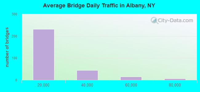
- 4,524,777Total average daily traffic
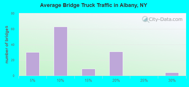
- 184,101Total average daily truck traffic
- National Bridge Inventory (NBI) Registered Bridges for Albany
- No street view available for this location
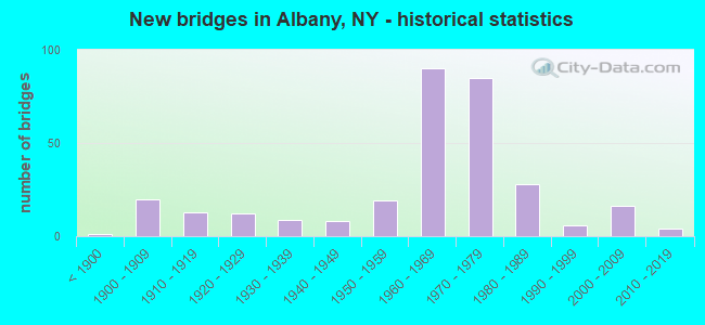
- New bridges - historical statistics
- 1Before 1900
- 201900-1909
- 131910-1919
- 121920-1929
- 91930-1939
- 81940-1949
- 191950-1959
- 901960-1969
- 851970-1979
- 281980-1989
- 61990-1999
- 162000-2009
- 42010-2019
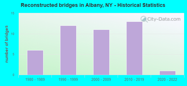
- Reconstructed bridges - Historical Statistics
- 61980-1989
- 121990-1999
- 112000-2009
- 132010-2019
- 12020-2022
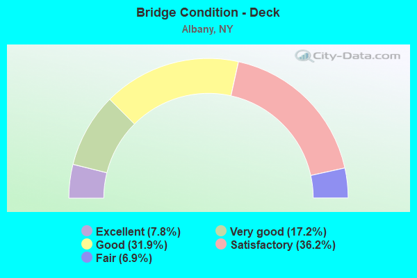
- Bridge Condition - Deck
- 7.8%Excellent
- 17.2%Very good
- 31.9%Good
- 36.2%Satisfactory
- 6.9%Fair
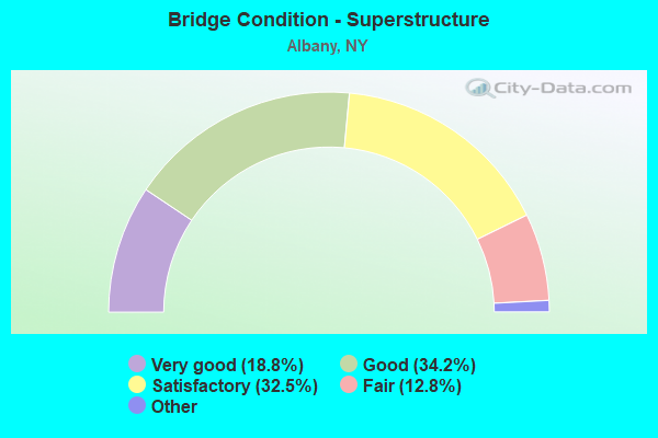
- Bridge Condition - Superstructure
- 18.8%Excellent
- 34.2%Very good
- 32.5%Good
- 12.8%Satisfactory
- 1.7%Fair
- 0.9%Poor
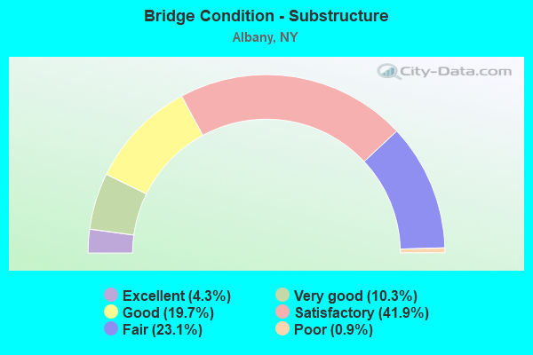
- Bridge Condition - Substructure
- 4.3%Excellent
- 10.3%Very good
- 19.7%Good
- 41.9%Satisfactory
- 23.1%Fair
- 0.9%Poor
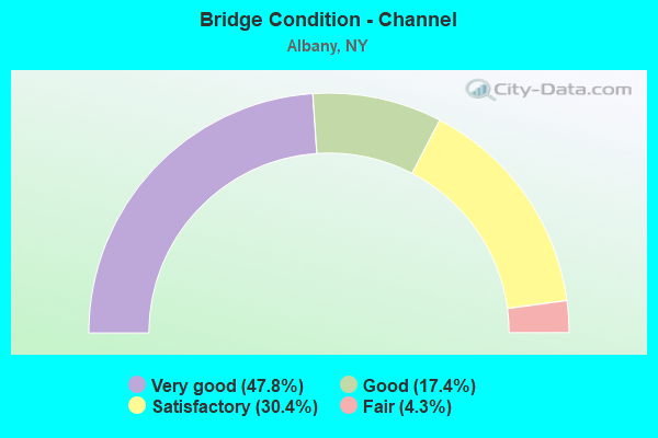
- Bridge Condition - Channel
- 47.8%Very good
- 17.4%Good
- 30.4%Satisfactory
- 4.3%Fair
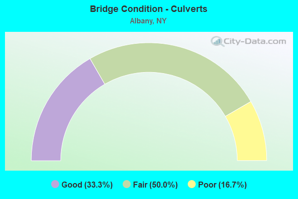
- Bridge Condition - Culverts
- 33.3%Good
- 50.0%Fair
- 16.7%Poor
Find on map >> Show street view
Structure Number: 107357, Location: RAPP RD.OVER TWY. (Lat: 42.702747, Lng: -73.850769), Route carried "on" structure: Other road , Year Built: 1986, Status: Open, Structure Length: 11.43m (37.50ft), Average Daily Traffic: 3,554 (year 2018), Truck Traffic: 3%, Average Future Daily Traffic: 4,397 (year 2040), Design Load: HS 20, Features Intersected: 90 I WB, RAMP 90IX/T WB, Facility Carried by Structure: RAPP ROAD
Minimum Vertical Clearance: 30+ m (98+ ft), Kilometerpoint: 0.177, Lanes on structure: 2, Lanes under structure: 8, Owner: State Toll Authority, Approaching Roadway Width: 13.1m (43.0ft), Material/Design: Steel continuous, Design/Construction: Stringer/Multi-beam, Number Of Spans In Main Unit: 2, Length of Maximum Span: 56.4m (185.0ft), Curb-To-Curb Width: 12.2m (40.0ft), Out-to-Out Width: 13.2m (43.3ft)
Condition: Deck: Good, Superstructure: Good, Substructure: Good, Operating Rating: 87.1 metric tons, Method Used To Determine Operating Rating: Load Factor (LF), Inventory Rating: 33.6 metric tons, Method Used To Determine Inventory Rating: Load Factor (LF), Structural Evaluation: Better than present minimum criteria, Deck Geometry: Equal to present minimum criteria, Underclear: Meets minimum limits, Approach Roadway Alignment: Equal to present desirable criteria, Length Of Structure Improvement: 11.43m (37.50ft), Designated Inspection Frequency: Every 24 months, Inspection Date: September 2021, Bridge Improvement Cost: $3,547,000, Roadway Improvement Cost: $2,077,000, Total Project Cost: $5,624,000 ( Estimate for 2021), Deck Structure Type: Concrete Cast-file-Place, Wearing Surface/Protective System: Wearing Surface: Integral Concrete, Deck Protection: Epoxy Coated Reinforcing
Find on map >> Show street view
Structure Number: 107358, Location: .2 MI W OF EXIT 24 TOLL (Lat: 42.705039, Lng: -73.853742), Route carried "on" structure: Ramp Interstate 90, Year Built: 1989, Status: Open, Structure Length: 9.78m (32.09ft), Average Daily Traffic: 62,811 (year 2020), Truck Traffic: 15%, Average Future Daily Traffic: 99,536 (year 2040), Design Load: HS 20+Mod, Features Intersected: RTE I90
Minimum Vertical Clearance: 30+ m (98+ ft), Kilometerpoint: 9.574, Lanes on structure: 2, Lanes under structure: 2, Base Highway Network: Yes, Toll: On toll road, Owner: State Toll Authority, Approaching Roadway Width: 12.8m (42.0ft), Material/Design: Steel, Design/Construction: Stringer/Multi-beam, Number Of Spans In Main Unit: 2, Length of Maximum Span: 48.2m (158.1ft), Curb-To-Curb Width: 12.0m (39.4ft), Out-to-Out Width: 13.0m (42.7ft)
Condition: Deck: Very good, Superstructure: Good, Substructure: Good, Operating Rating: 84.4 metric tons, Method Used To Determine Operating Rating: Load Factor (LF), Inventory Rating: 35.4 metric tons, Method Used To Determine Inventory Rating: Load Factor (LF), Structural Evaluation: Better than present minimum criteria, Deck Geometry: Superior to present desirable criteria, Underclear: High priority of corrective action, Approach Roadway Alignment: Equal to present desirable criteria, Length Of Structure Improvement: 9.78m (32.09ft), Designated Inspection Frequency: Every 24 months, Critical Feature Inspection Frequency: Every 24 months, Inspection Date: July 2021, Critical Feature Inspection Date: July 2021, Bridge Improvement Cost: $2,636,000, Roadway Improvement Cost: $1,544,000, Total Project Cost: $4,180,000 ( Estimate for 2021), Deck Structure Type: Concrete Cast-file-Place, Wearing Surface/Protective System: Wearing Surface: Integral Concrete
Find on map >> Show street view
Structure Number: 107494, Location: GREEN- BROADWAY-QUAY CONN (Lat: 42.644750, Lng: -73.748953), Route carried "on" structure: City street , Year Built: 1969, Status: Open, Structure Length: 25.42m (83.40ft), Average Daily Traffic: 3,780 (year 2016), Truck Traffic: 5%, Average Future Daily Traffic: 5,292 (year 2036), Design Load: HS 20+Mod, Features Intersected: HUDSON RIVER SHRE, Facility Carried by Structure: QUAY STREET
Minimum Vertical Clearance: 30+ m (98+ ft), Kilometerpoint: 0.016, Lanes on structure: 1, Owner: State Highway Agency, Approaching Roadway Width: 4.0m (13.1ft), Skew: 20 degrees, Material/Design: Concrete, Design/Construction: Box Beam or Girders - Multiple, Number Of Spans In Main Unit: 26, Length of Maximum Span: 9.8m (32.2ft), Curb or Sidewalk Widths: Left: 1.2m (3.9ft), Right: 3.0m (9.8ft), Curb-To-Curb Width: 7.0m (23.0ft), Out-to-Out Width: 12.8m (42.0ft)
Condition: Deck: Fair, Superstructure: Satisfactory, Substructure: Fair, Channel: Very good, Operating Rating: 67.1 metric tons, Method Used To Determine Operating Rating: Load Factor (LF), Inventory Rating: 39.9 metric tons, Method Used To Determine Inventory Rating: Load Factor (LF), Structural Evaluation: Somewhat better than minimum adequacy, Deck Geometry: High priority of replacement, Waterway Adequacy: Superior to present desirable criteria, Approach Roadway Alignment: Equal to present desirable criteria, Length Of Structure Improvement: 25.42m (83.40ft), Designated Inspection Frequency: Every 24 months, Underwater Inspection Frequency: Every 60 months, Inspection Date: December 2020, Underwater Inspection Date: December 2020, Bridge Improvement Cost: $8,453,000, Roadway Improvement Cost: $4,950,000, Total Project Cost: $13,404,000 ( Estimate for 2021), Wearing Surface/Protective System: Wearing Surface: Integral Concrete
Find on map >> Show street view
Structure Number: 1078661, Location: Jct I90 & Everett Rd. (Lat: 42.681883, Lng: -73.780386), Route carried "on" structure: Interstate 90, Year Built: 2006, Status: Open, Structure Length: 10.24m (33.60ft), Average Daily Traffic: 41,773 (year 2013), Truck Traffic: 9%, Average Future Daily Traffic: 58,482 (year 2033), Design Load: HL 93, Features Intersected: CSX/Amtrak
Minimum Vertical Clearance: 30+ m (98+ ft), Kilometerpoint: 16.476, Lanes on structure: 4, Base Highway Network: Yes, Owner: State Highway Agency, Approaching Roadway Width: 20.1m (65.9ft), Skew: 6 degrees, Material/Design: Steel continuous, Design/Construction: Stringer/Multi-beam, Number Of Spans In Main Unit: 2, Length of Maximum Span: 49.8m (163.4ft), Curb-To-Curb Width: 20.3m (66.6ft), Out-to-Out Width: 21.2m (69.6ft)
Condition: Deck: Good, Superstructure: Very good, Substructure: Very good, Operating Rating: 88.0 metric tons, Method Used To Determine Operating Rating: Load Factor (LF), Inventory Rating: 52.0 metric tons, Method Used To Determine Inventory Rating: Load Factor (LF), Structural Evaluation: Equal to present desirable criteria, Deck Geometry: Equal to present minimum criteria, Underclear: Somewhat better than minimum adequacy, Approach Roadway Alignment: Equal to present desirable criteria, Length Of Structure Improvement: 10.24m (33.60ft), Designated Inspection Frequency: Every 24 months, Inspection Date: November 2020, Bridge Improvement Cost: $6,268,000, Roadway Improvement Cost: $3,671,000, Total Project Cost: $9,939,000 ( Estimate for 2021), Deck Structure Type: Concrete Cast-file-Place, Wearing Surface/Protective System: Wearing Surface: Integral Concrete
Find on map >> Show street view
Structure Number: 1078662, Location: Jct I90 & Everett Rd (Lat: 42.681753, Lng: -73.780178), Route carried "on" structure: Interstate 90, Year Built: 2006, Status: Open, Structure Length: 10.24m (33.60ft), Average Daily Traffic: 36,512 (year 2019), Truck Traffic: 5%, Average Future Daily Traffic: 57,860 (year 2040), Design Load: HL 93, Features Intersected: CSX/AMTRAK
Minimum Vertical Clearance: 30+ m (98+ ft), Kilometerpoint: 16.492, Lanes on structure: 4, Base Highway Network: Yes, Owner: State Highway Agency, Approaching Roadway Width: 18.9m (62.0ft), Skew: 6 degrees, Material/Design: Steel continuous, Design/Construction: Stringer/Multi-beam, Number Of Spans In Main Unit: 2, Length of Maximum Span: 49.8m (163.4ft), Curb-To-Curb Width: 19.1m (62.7ft), Out-to-Out Width: 19.9m (65.3ft)
Condition: Deck: Good, Superstructure: Very good, Substructure: Very good, Operating Rating: 99.0 metric tons, Method Used To Determine Operating Rating: Load Factor (LF), Inventory Rating: 59.0 metric tons, Method Used To Determine Inventory Rating: Load Factor (LF), Structural Evaluation: Equal to present desirable criteria, Deck Geometry: Somewhat better than minimum adequacy, Underclear: Somewhat better than minimum adequacy, Approach Roadway Alignment: Equal to present desirable criteria, Length Of Structure Improvement: 10.24m (33.60ft), Designated Inspection Frequency: Every 24 months, Inspection Date: November 2020, Bridge Improvement Cost: $5,907,000, Roadway Improvement Cost: $3,459,000, Total Project Cost: $9,366,000 ( Estimate for 2021), Deck Structure Type: Concrete Cast-file-Place, Wearing Surface/Protective System: Wearing Surface: Integral Concrete
Find on map >> Show street view
Structure Number: 107944, Location: WASHINGTON AVE. EXT. OVER (Lat: 42.693306, Lng: -73.830869), Route carried "on" structure: Alternate City street 910, Year Built: 2012, Status: Open, Structure Length: 3.02m (9.91ft), Average Daily Traffic: 18,413 (year 2020), Truck Traffic: 5%, Average Future Daily Traffic: 21,336 (year 2040), Design Load: HS 20, Features Intersected: Fuller Rd
Minimum Vertical Clearance: 30+ m (98+ ft), Kilometerpoint: 4.682, Lanes on structure: 4, Lanes under structure: 2, Base Highway Network: Yes, Owner: State Highway Agency, Approaching Roadway Width: 21.0m (68.9ft), Skew: 20 degrees, Material/Design: Steel, Design/Construction: Stringer/Multi-beam, Number Of Spans In Main Unit: 1, Length of Maximum Span: 29.0m (95.1ft), Curb-To-Curb Width: 21.0m (68.9ft), Out-to-Out Width: 21.9m (71.9ft)
Condition: Deck: Very good, Superstructure: Very good, Substructure: Very good, Operating Rating: 68.0 metric tons, Method Used To Determine Operating Rating: Load and Resistance Factor Rating (LRFR) rating reported by rating factor(RF) method using HL-93 loadings, Inventory Rating: 52.5 metric tons, Method Used To Determine Inventory Rating: Load and Resistance Factor Rating (LRFR) rating reported by rating factor(RF) method using HL-93 loadings, Structural Evaluation: Equal to present desirable criteria, Deck Geometry: Better than present minimum criteria, Underclear: Equal to present minimum criteria, Approach Roadway Alignment: Equal to present minimum criteria, Length Of Structure Improvement: 3.01m (9.88ft), Designated Inspection Frequency: Every 24 months, Inspection Date: March 2021, Bridge Improvement Cost: $1,570,000, Roadway Improvement Cost: $920,000, Total Project Cost: $2,490,000 ( Estimate for 2021), Deck Structure Type: Concrete Cast-file-Place, Wearing Surface/Protective System: Wearing Surface: Integral Concrete, Deck Protection: Epoxy Coated Reinforcing
Find on map >> Show street view
Structure Number: 107945, Location: Washington ave. ext. over (Lat: 42.693189, Lng: -73.830361), Route carried "on" structure: Alternate City street 910, Year Built: 2012, Status: Open, Structure Length: 3.02m (9.91ft), Average Daily Traffic: 18,413 (year 2020), Truck Traffic: 5%, Average Future Daily Traffic: 21,336 (year 2040), Design Load: HS 20, Features Intersected: Fuller rd. rounda
Minimum Vertical Clearance: 30+ m (98+ ft), Kilometerpoint: 4.682, Lanes on structure: 4, Lanes under structure: 2, Base Highway Network: Yes, Owner: State Highway Agency, Approaching Roadway Width: 21.0m (68.9ft), Skew: 20 degrees, Material/Design: Steel, Design/Construction: Stringer/Multi-beam, Number Of Spans In Main Unit: 1, Length of Maximum Span: 29.0m (95.1ft), Curb-To-Curb Width: 21.0m (68.9ft), Out-to-Out Width: 21.9m (71.9ft)
Condition: Deck: Very good, Superstructure: Very good, Substructure: Very good, Operating Rating: 68.0 metric tons, Method Used To Determine Operating Rating: Load and Resistance Factor Rating (LRFR) rating reported by rating factor(RF) method using HL-93 loadings, Inventory Rating: 52.5 metric tons, Method Used To Determine Inventory Rating: Load and Resistance Factor Rating (LRFR) rating reported by rating factor(RF) method using HL-93 loadings, Structural Evaluation: Equal to present desirable criteria, Deck Geometry: Better than present minimum criteria, Underclear: Equal to present minimum criteria, Approach Roadway Alignment: Equal to present minimum criteria, Length Of Structure Improvement: 3.01m (9.88ft), Designated Inspection Frequency: Every 24 months, Inspection Date: March 2021, Bridge Improvement Cost: $1,570,000, Roadway Improvement Cost: $920,000, Total Project Cost: $2,490,000 ( Estimate for 2021), Deck Structure Type: Concrete Cast-file-Place, Wearing Surface/Protective System: Wearing Surface: Integral Concrete, Deck Protection: Epoxy Coated Reinforcing
Find on map >> Show street view
Structure Number: 1092421, Location: JCT I90 & I787 (Lat: 42.667403, Lng: -73.732833), Route carried "on" structure: Ramp Interstate 90, Year Built: 1968, Year Reconstructed: 2016, Status: Open, Structure Length: 7.62m (25.00ft), Average Daily Traffic: 4,746 (year 2020), Truck Traffic: 3%, Average Future Daily Traffic: 7,521 (year 2040), Design Load: HS 20, Features Intersected: 787I787I11011038, 90I 90
Minimum Vertical Clearance: 4.74m (15.55ft), Kilometerpoint: 0.193, Lanes on structure: 1, Lanes under structure: 11, Owner: State Highway Agency, Approaching Roadway Width: 6.1m (20.0ft), Skew: 4 degrees, Material/Design: Steel, Design/Construction: Stringer/Multi-beam, Number Of Spans In Main Unit: 4, Length of Maximum Span: 19.5m (64.0ft), Curb-To-Curb Width: 6.1m (20.0ft), Out-to-Out Width: 7.0m (23.0ft)
Condition: Deck: Excellent, Superstructure: Good, Substructure: Excellent, Operating Rating: 63.5 metric tons, Method Used To Determine Operating Rating: Load Factor (LF), Inventory Rating: 37.2 metric tons, Method Used To Determine Inventory Rating: Load Factor (LF), Structural Evaluation: Better than present minimum criteria, Deck Geometry: Meets minimum limits, Underclear: High priority of corrective action, Approach Roadway Alignment: Equal to present desirable criteria, Length Of Structure Improvement: 7.62m (25.00ft), Designated Inspection Frequency: Every 24 months, Inspection Date: November 2020, Bridge Improvement Cost: $1,154,000, Roadway Improvement Cost: $676,000, Total Project Cost: $1,830,000 ( Estimate for 2021), Deck Structure Type: Concrete Precast Panels, Wearing Surface/Protective System: Wearing Surface: Latex Concrete
Find on map >> Show street view
Structure Number: 1092422, Location: JCT I90 & I787 (Lat: 42.667267, Lng: -73.733417), Route carried "on" structure: Ramp Interstate 90, Year Built: 1968, Year Reconstructed: 2016, Status: Open, Structure Length: 7.62m (25.00ft), Average Daily Traffic: 2,423 (year 2020), Truck Traffic: 18%, Average Future Daily Traffic: 3,839 (year 2040), Design Load: HS 20, Features Intersected: 787I787I11011038, 90I 90
Minimum Vertical Clearance: 4.77m (15.65ft), Kilometerpoint: 0.177, Lanes on structure: 1, Lanes under structure: 11, Owner: State Highway Agency, Approaching Roadway Width: 6.1m (20.0ft), Skew: 4 degrees, Material/Design: Steel, Design/Construction: Stringer/Multi-beam, Number Of Spans In Main Unit: 4, Length of Maximum Span: 19.5m (64.0ft), Curb-To-Curb Width: 6.1m (20.0ft), Out-to-Out Width: 7.0m (23.0ft)
Condition: Deck: Excellent, Superstructure: Good, Substructure: Excellent, Operating Rating: 68.7 metric tons, Method Used To Determine Operating Rating: Load and Resistance Factor Rating (LRFR) rating reported by rating factor(RF) method using HL-93 loadings, Inventory Rating: 52.8 metric tons, Method Used To Determine Inventory Rating: Load and Resistance Factor Rating (LRFR) rating reported by rating factor(RF) method using HL-93 loadings, Structural Evaluation: Better than present minimum criteria, Deck Geometry: Meets minimum limits, Underclear: High priority of corrective action, Approach Roadway Alignment: Equal to present desirable criteria, Length Of Structure Improvement: 7.62m (25.00ft), Designated Inspection Frequency: Every 24 months, Inspection Date: November 2020, Bridge Improvement Cost: $1,165,000, Roadway Improvement Cost: $682,000, Total Project Cost: $1,847,000 ( Estimate for 2021), Deck Structure Type: Concrete Precast Panels, Wearing Surface/Protective System: Wearing Surface: Latex Concrete
Find on map >> Show street view
Structure Number: 1092431, Location: JCT I90 & I787 (Lat: 42.667214, Lng: -73.732800), Route carried "on" structure: Interstate 90, Year Built: 1968, Year Reconstructed: 2014, Status: Open, Structure Length: 9.78m (32.09ft), Average Daily Traffic: 35,394 (year 1998), Truck Traffic: 9%, Design Load: HS 20, Features Intersected: 787IX SB, 90IX EB Ramp,
Minimum Vertical Clearance: 5.18m (16.99ft), Kilometerpoint: 9.815, Lanes on structure: 2, Lanes under structure: 9, Base Highway Network: Yes, Owner: State Highway Agency, Approaching Roadway Width: 9.1m (29.9ft), Material/Design: Steel, Design/Construction: Stringer/Multi-beam, Number Of Spans In Main Unit: 3, Length of Maximum Span: 34.1m (111.9ft), Curb-To-Curb Width: 9.2m (30.2ft), Out-to-Out Width: 10.1m (33.1ft)
Condition: Deck: Excellent, Superstructure: Satisfactory, Substructure: Satisfactory, Operating Rating: 86.5 metric tons, Method Used To Determine Operating Rating: Load and Resistance Factor Rating (LRFR) rating reported by rating factor(RF) method using HL-93 loadings, Inventory Rating: 66.7 metric tons, Method Used To Determine Inventory Rating: Load and Resistance Factor Rating (LRFR) rating reported by rating factor(RF) method using HL-93 loadings, Structural Evaluation: Equal to present minimum criteria, Deck Geometry: Meets minimum limits, Underclear: High priority of corrective action, Approach Roadway Alignment: Equal to present desirable criteria, Length Of Structure Improvement: 9.78m (32.09ft), Designated Inspection Frequency: Every 24 months, Critical Feature Inspection Frequency: Every 12 months, Inspection Date: October 2020, Critical Feature Inspection Date: October 2020, Bridge Improvement Cost: $2,043,000, Roadway Improvement Cost: $1,197,000, Total Project Cost: $3,240,000 ( Estimate for 2021), Deck Structure Type: Other, Wearing Surface/Protective System: Wearing Surface: Integral Concrete
Find on map >> Show street view
Structure Number: 1092432, Location: JCT I90 & I787 (Lat: 42.667419, Lng: -73.733389), Route carried "on" structure: Interstate 90, Year Built: 1968, Year Reconstructed: 2014, Status: Open, Structure Length: 9.75m (31.99ft), Average Daily Traffic: 29,439 (year 2019), Truck Traffic: 6%, Average Future Daily Traffic: 46,652 (year 2040), Design Load: HS 20, Features Intersected: 787IX SB, 90IX EB Ramp,
Minimum Vertical Clearance: 5.13m (16.83ft), Kilometerpoint: 20.837, Lanes on structure: 2, Lanes under structure: 9, Base Highway Network: Yes, Owner: State Highway Agency, Approaching Roadway Width: 12.2m (40.0ft), Material/Design: Steel, Design/Construction: Stringer/Multi-beam, Number Of Spans In Main Unit: 3, Length of Maximum Span: 34.1m (111.9ft), Curb-To-Curb Width: 9.2m (30.2ft), Out-to-Out Width: 10.1m (33.1ft)
Condition: Deck: Excellent, Superstructure: Satisfactory, Substructure: Satisfactory, Operating Rating: 86.5 metric tons, Method Used To Determine Operating Rating: Load and Resistance Factor Rating (LRFR) rating reported by rating factor(RF) method using HL-93 loadings, Inventory Rating: 66.7 metric tons, Method Used To Determine Inventory Rating: Load and Resistance Factor Rating (LRFR) rating reported by rating factor(RF) method using HL-93 loadings, Structural Evaluation: Equal to present minimum criteria, Deck Geometry: Meets minimum limits, Underclear: High priority of corrective action, Approach Roadway Alignment: Equal to present desirable criteria, Length Of Structure Improvement: 9.75m (31.99ft), Designated Inspection Frequency: Every 24 months, Critical Feature Inspection Frequency: Every 24 months, Inspection Date: October 2020, Critical Feature Inspection Date: October 2020, Bridge Improvement Cost: $2,038,000, Roadway Improvement Cost: $1,193,000, Total Project Cost: $3,231,000 ( Estimate for 2021), Deck Structure Type: Other, Wearing Surface/Protective System: Wearing Surface: Integral Concrete
Find on map >> Show street view
Structure Number: 1092441, Location: 0.3 MI N JCT I90 & I787 (Lat: 42.667039, Lng: -73.733003), Route carried "on" structure: Ramp Interstate , Year Built: 1968, Year Reconstructed: 2016, Status: Open, Structure Length: 21.31m (69.91ft), Average Daily Traffic: 4,845 (year 2020), Truck Traffic: 9%, Average Future Daily Traffic: 7,677 (year 2040), Design Load: HS 20, Features Intersected: 787I787I11011038, 90I 90, Facility Carried by Structure: I787 SB to I90 EB
Minimum Vertical Clearance: 30+ m (98+ ft), Kilometerpoint: 0.064, Lanes on structure: 1, Lanes under structure: 10, Owner: State Highway Agency, Approaching Roadway Width: 6.4m (21.0ft), Skew: 1 degrees, Material/Design: Steel, Design/Construction: Stringer/Multi-beam, Number Of Spans In Main Unit: 8, Length of Maximum Span: 42.7m (140.1ft), Curb-To-Curb Width: 6.1m (20.0ft), Out-to-Out Width: 7.3m (24.0ft)
Condition: Deck: Excellent, Superstructure: Excellent, Substructure: Excellent, Operating Rating: 65.3 metric tons, Method Used To Determine Operating Rating: Load Factor (LF), Inventory Rating: 39.0 metric tons, Method Used To Determine Inventory Rating: Load Factor (LF), Structural Evaluation: Superior to present desirable criteria, Deck Geometry: Somewhat better than minimum adequacy, Underclear: High priority of corrective action, Approach Roadway Alignment: Equal to present desirable criteria, Length Of Structure Improvement: 21.30m (69.88ft), Designated Inspection Frequency: Every 24 months, Critical Feature Inspection Frequency: Every 24 months, Inspection Date: October 2020, Critical Feature Inspection Date: October 2020, Bridge Improvement Cost: $3,071,000, Roadway Improvement Cost: $1,798,000, Total Project Cost: $4,870,000 ( Estimate for 2021), Deck Structure Type: Concrete Precast Panels, Wearing Surface/Protective System: Wearing Surface: Latex Concrete
Find on map >> Show street view
Structure Number: 1092442, Location: 0.3 MI N JCT I90 & I787 (Lat: 42.667156, Lng: -73.733192), Route carried "on" structure: Ramp Interstate , Year Built: 1968, Year Reconstructed: 2014, Status: Open, Structure Length: 21.49m (70.51ft), Average Daily Traffic: 6,030 (year 2020), Truck Traffic: 5%, Average Future Daily Traffic: 9,555 (year 2040), Design Load: HS 20, Features Intersected: 787I787I11011038 NB, 90I, Facility Carried by Structure: RAMP I787 NB to I9
Minimum Vertical Clearance: 30+ m (98+ ft), Kilometerpoint: 0.097, Lanes on structure: 2, Lanes under structure: 10, Owner: State Highway Agency, Approaching Roadway Width: 9.8m (32.2ft), Skew: 1 degrees, Material/Design: Steel, Design/Construction: Stringer/Multi-beam, Number Of Spans In Main Unit: 7, Length of Maximum Span: 42.1m (138.1ft), Curb-To-Curb Width: 9.8m (32.2ft), Out-to-Out Width: 10.9m (35.8ft)
Condition: Deck: Excellent, Superstructure: Satisfactory, Substructure: Good, Operating Rating: 68.0 metric tons, Method Used To Determine Operating Rating: Load and Resistance Factor Rating (LRFR) rating reported by rating factor(RF) method using HL-93 loadings, Inventory Rating: 52.5 metric tons, Method Used To Determine Inventory Rating: Load and Resistance Factor Rating (LRFR) rating reported by rating factor(RF) method using HL-93 loadings, Structural Evaluation: Equal to present minimum criteria, Deck Geometry: Equal to present minimum criteria, Underclear: High priority of corrective action, Approach Roadway Alignment: Equal to present desirable criteria, Length Of Structure Improvement: 21.48m (70.47ft), Designated Inspection Frequency: Every 24 months, Critical Feature Inspection Frequency: Every 24 months, Inspection Date: September 2021, Critical Feature Inspection Date: September 2021, Bridge Improvement Cost: $4,649,000, Roadway Improvement Cost: $2,722,000, Total Project Cost: $7,372,000 ( Estimate for 2021), Deck Structure Type: Concrete Precast Panels, Wearing Surface/Protective System: Wearing Surface: Latex Concrete
Find on map >> Show street view
Structure Number: 1092451, Location: 0.3 MI NW JCT I90 & I787 (Lat: 42.669300, Lng: -73.736256), Route carried "on" structure: Interstate 90, Year Built: 1967, Year Reconstructed: 2004, Status: Open, Structure Length: 9.17m (30.09ft), Average Daily Traffic: 35,394 (year 1998), Truck Traffic: 9%, Design Load: HS 20, Features Intersected: ERIE BLVD, DELAWARE & HU
Minimum Vertical Clearance: 30+ m (98+ ft), Kilometerpoint: 20.434, Lanes on structure: 5, Lanes under structure: 2, Base Highway Network: Yes, Owner: State Highway Agency, Approaching Roadway Width: 22.9m (75.1ft), Material/Design: Steel, Design/Construction: Stringer/Multi-beam, Number Of Spans In Main Unit: 4, Length of Maximum Span: 31.3m (102.7ft), Curb-To-Curb Width: 22.1m (72.5ft), Out-to-Out Width: 23.1m (75.8ft)
Condition: Deck: Satisfactory, Superstructure: Satisfactory, Substructure: Fair, Operating Rating: 58.1 metric tons, Method Used To Determine Operating Rating: Load Factor (LF), Inventory Rating: 32.7 metric tons, Method Used To Determine Inventory Rating: Load Factor (LF), Structural Evaluation: Somewhat better than minimum adequacy, Deck Geometry: Meets minimum limits, Underclear: High priority of corrective action, Approach Roadway Alignment: Equal to present desirable criteria, Length Of Structure Improvement: 9.17m (30.09ft), Designated Inspection Frequency: Every 24 months, Inspection Date: August 2020, Bridge Improvement Cost: $4,368,000, Roadway Improvement Cost: $2,558,000, Total Project Cost: $6,926,000 ( Estimate for 2021), Deck Structure Type: Concrete Cast-file-Place, Wearing Surface/Protective System: Wearing Surface: Integral Concrete
Find on map >> Show street view
Structure Number: 1092452, Location: 0.3 MI NW JCT I90 & I787 (Lat: 42.669178, Lng: -73.736333), Route carried "on" structure: Interstate 90, Year Built: 1968, Year Reconstructed: 1996, Status: Open, Structure Length: 8.99m (29.49ft), Average Daily Traffic: 29,439 (year 2019), Truck Traffic: 6%, Average Future Daily Traffic: 46,652 (year 2040), Design Load: HS 20, Features Intersected: ERIE BLVD., DELAWARE & H
Minimum Vertical Clearance: 30+ m (98+ ft), Kilometerpoint: 20.483, Lanes on structure: 4, Lanes under structure: 2, Base Highway Network: Yes, Owner: State Highway Agency, Approaching Roadway Width: 19.5m (64.0ft), Material/Design: Steel, Design/Construction: Stringer/Multi-beam, Number Of Spans In Main Unit: 4, Length of Maximum Span: 31.3m (102.7ft), Curb-To-Curb Width: 16.0m (52.5ft), Out-to-Out Width: 17.6m (57.7ft)
Condition: Deck: Satisfactory, Superstructure: Satisfactory, Substructure: Satisfactory, Operating Rating: 58.1 metric tons, Method Used To Determine Operating Rating: Load Factor (LF), Inventory Rating: 32.7 metric tons, Method Used To Determine Inventory Rating: Load Factor (LF), Structural Evaluation: Equal to present minimum criteria, Deck Geometry: Meets minimum limits, Underclear: High priority of corrective action, Approach Roadway Alignment: Equal to present desirable criteria, Length Of Structure Improvement: 8.99m (29.49ft), Designated Inspection Frequency: Every 24 months, Inspection Date: August 2020, Bridge Improvement Cost: $3,381,000, Roadway Improvement Cost: $1,980,000, Total Project Cost: $5,360,000 ( Estimate for 2021), Deck Structure Type: Concrete Cast-file-Place, Wearing Surface/Protective System: Wearing Surface: Integral Concrete
Find on map >> Show street view
Structure Number: 1092461, Location: 0.5 MI NW JCT I90 & I787 (Lat: 42.670225, Lng: -73.739289), Route carried "on" structure: Interstate 90, Year Built: 1967, Year Reconstructed: 2017, Status: Open, Structure Length: 5.39m (17.68ft), Average Daily Traffic: 54,421 (year 2000), Truck Traffic: 9%, Design Load: HS 20, Features Intersected: BROADWAY
Minimum Vertical Clearance: 30+ m (98+ ft), Kilometerpoint: 9.332, Lanes on structure: 4, Lanes under structure: 2, Base Highway Network: Yes, Owner: State Highway Agency, Approaching Roadway Width: 19.5m (64.0ft), Skew: 1 degrees, Material/Design: Steel, Design/Construction: Stringer/Multi-beam, Number Of Spans In Main Unit: 3, Length of Maximum Span: 25.6m (84.0ft), Curb-To-Curb Width: 16.4m (53.8ft), Out-to-Out Width: 17.5m (57.4ft)
Condition: Deck: Good, Superstructure: Good, Substructure: Good, Operating Rating: 58.1 metric tons, Method Used To Determine Operating Rating: Load Factor (LF), Inventory Rating: 32.7 metric tons, Method Used To Determine Inventory Rating: Load Factor (LF), Structural Evaluation: Better than present minimum criteria, Deck Geometry: High priority of replacement, Underclear: Somewhat better than minimum adequacy, Approach Roadway Alignment: Equal to present desirable criteria, Length Of Structure Improvement: 5.39m (17.68ft), Designated Inspection Frequency: Every 24 months, Inspection Date: May 2020, Bridge Improvement Cost: $2,142,000, Roadway Improvement Cost: $1,254,000, Total Project Cost: $3,397,000 ( Estimate for 2021), Deck Structure Type: Concrete Cast-file-Place, Wearing Surface/Protective System: Wearing Surface: Integral Concrete
Find on map >> Show street view
Structure Number: 1092462, Location: 0.5 MI NW JCT I90 & I787 (Lat: 42.670000, Lng: -73.739425), Route carried "on" structure: Interstate 90, Year Built: 1967, Status: Open, Structure Length: 5.39m (17.68ft), Average Daily Traffic: 29,439 (year 2019), Truck Traffic: 6%, Average Future Daily Traffic: 46,652 (year 2040), Design Load: HS 20, Features Intersected: BROADWAY
Minimum Vertical Clearance: 30+ m (98+ ft), Kilometerpoint: 20.241, Lanes on structure: 4, Lanes under structure: 2, Base Highway Network: Yes, Owner: State Highway Agency, Approaching Roadway Width: 19.5m (64.0ft), Skew: 1 degrees, Material/Design: Steel, Design/Construction: Stringer/Multi-beam, Number Of Spans In Main Unit: 3, Length of Maximum Span: 25.6m (84.0ft), Curb-To-Curb Width: 16.4m (53.8ft), Out-to-Out Width: 17.5m (57.4ft)
Condition: Deck: Good, Superstructure: Good, Substructure: Good, Operating Rating: 58.1 metric tons, Method Used To Determine Operating Rating: Load Factor (LF), Inventory Rating: 32.7 metric tons, Method Used To Determine Inventory Rating: Load Factor (LF), Structural Evaluation: Better than present minimum criteria, Deck Geometry: High priority of replacement, Underclear: Somewhat better than minimum adequacy, Approach Roadway Alignment: Equal to present desirable criteria, Length Of Structure Improvement: 5.39m (17.68ft), Designated Inspection Frequency: Every 24 months, Inspection Date: May 2020, Bridge Improvement Cost: $2,140,000, Roadway Improvement Cost: $1,253,000, Total Project Cost: $3,394,000 ( Estimate for 2021), Deck Structure Type: Concrete Cast-file-Place, Wearing Surface/Protective System: Wearing Surface: Integral Concrete
Find on map >> Show street view
Structure Number: 1092471, Location: 0.6 MI NW JCT I90 & I787 (Lat: 42.670217, Lng: -73.741356), Route carried "on" structure: Interstate 90, Year Built: 1967, Year Reconstructed: 1996, Status: Open, Structure Length: 5.79m (19.00ft), Average Daily Traffic: 54,421 (year 2000), Truck Traffic: 9%, Design Load: HS 20, Features Intersected: NO.PEARL ST. RT32
Minimum Vertical Clearance: 30+ m (98+ ft), Kilometerpoint: 20.032, Lanes on structure: 4, Lanes under structure: 2, Base Highway Network: Yes, Owner: State Highway Agency, Approaching Roadway Width: 20.1m (65.9ft), Skew: 3 degrees, Material/Design: Steel, Design/Construction: Stringer/Multi-beam, Number Of Spans In Main Unit: 3, Length of Maximum Span: 21.9m (71.9ft), Curb-To-Curb Width: 16.5m (54.1ft), Out-to-Out Width: 17.5m (57.4ft)
Condition: Deck: Satisfactory, Superstructure: Satisfactory, Substructure: Satisfactory, Operating Rating: 79.8 metric tons, Method Used To Determine Operating Rating: Load Factor (LF), Inventory Rating: 47.2 metric tons, Method Used To Determine Inventory Rating: Load Factor (LF), Structural Evaluation: Equal to present minimum criteria, Deck Geometry: High priority of replacement, Underclear: Meets minimum limits, Approach Roadway Alignment: Equal to present desirable criteria, Length Of Structure Improvement: 5.79m (19.00ft), Designated Inspection Frequency: Every 24 months, Inspection Date: June 2020, Bridge Improvement Cost: $2,189,000, Roadway Improvement Cost: $1,282,000, Total Project Cost: $3,470,000 ( Estimate for 2021), Deck Structure Type: Concrete Cast-file-Place, Wearing Surface/Protective System: Wearing Surface: Integral Concrete
Find on map >> Show street view
Structure Number: 1092472, Location: 0.6 MI NW JCT I90 & I787 (Lat: 42.669983, Lng: -73.741497), Route carried "on" structure: Interstate 90, Year Built: 1967, Status: Open, Structure Length: 5.79m (19.00ft), Average Daily Traffic: 29,439 (year 2019), Truck Traffic: 6%, Average Future Daily Traffic: 46,652 (year 2040), Design Load: HS 20, Features Intersected: NO.PEARL ST-RT 32
Minimum Vertical Clearance: 30+ m (98+ ft), Kilometerpoint: 20.080, Lanes on structure: 4, Lanes under structure: 2, Base Highway Network: Yes, Owner: State Highway Agency, Approaching Roadway Width: 20.1m (65.9ft), Skew: 3 degrees, Material/Design: Steel, Design/Construction: Stringer/Multi-beam, Number Of Spans In Main Unit: 3, Length of Maximum Span: 21.9m (71.9ft), Curb-To-Curb Width: 16.5m (54.1ft), Out-to-Out Width: 17.5m (57.4ft)
Condition: Deck: Satisfactory, Superstructure: Satisfactory, Substructure: Satisfactory, Operating Rating: 79.8 metric tons, Method Used To Determine Operating Rating: Load Factor (LF), Inventory Rating: 47.2 metric tons, Method Used To Determine Inventory Rating: Load Factor (LF), Structural Evaluation: Equal to present minimum criteria, Deck Geometry: High priority of replacement, Underclear: Meets minimum limits, Approach Roadway Alignment: Equal to present desirable criteria, Length Of Structure Improvement: 5.79m (19.00ft), Designated Inspection Frequency: Every 24 months, Inspection Date: June 2020, Bridge Improvement Cost: $2,282,000, Roadway Improvement Cost: $1,337,000, Total Project Cost: $3,619,000 ( Estimate for 2021), Deck Structure Type: Concrete Cast-file-Place, Wearing Surface/Protective System: Wearing Surface: Integral Concrete
Find on map >> Show street view
Structure Number: 109248, Location: LOUDONVILLE RD & I90 RAMP (Lat: 42.669758, Lng: -73.745053), Route carried "on" structure: City street , Year Built: 1970, Status: Open, Structure Length: 15.21m (49.90ft), Average Daily Traffic: 4,644 (year 2017), Truck Traffic: 6%, Average Future Daily Traffic: 5,641 (year 2040), Design Load: HS 20+Mod, Features Intersected: 90I 90I11012011WB, I 90, Facility Carried by Structure: LOUDONVILLE ROAD
Minimum Vertical Clearance: 30+ m (98+ ft), Kilometerpoint: 0.563, Lanes on structure: 4, Lanes under structure: 11, Owner: State Highway Agency, Approaching Roadway Width: 15.8m (51.8ft), Skew: 20 degrees, Material/Design: Steel, Design/Construction: Stringer/Multi-beam, Number Of Spans In Main Unit: 5, Length of Maximum Span: 33.2m (108.9ft), Curb or Sidewalk Widths: Left: 2.3m (7.5ft), Right: 2.3m (7.5ft), Curb-To-Curb Width: 15.8m (51.8ft), Out-to-Out Width: 21.3m (69.9ft)
Condition: Deck: Satisfactory, Superstructure: Fair, Substructure: Satisfactory, Operating Rating: 61.7 metric tons, Method Used To Determine Operating Rating: Load Factor (LF), Inventory Rating: 31.8 metric tons, Method Used To Determine Inventory Rating: Load Factor (LF), Structural Evaluation: Somewhat better than minimum adequacy, Deck Geometry: Meets minimum limits, Underclear: Meets minimum limits, Approach Roadway Alignment: Equal to present desirable criteria, Length Of Structure Improvement: 15.20m (49.87ft), Designated Inspection Frequency: Every 24 months, Inspection Date: September 2021, Bridge Improvement Cost: $7,023,000, Roadway Improvement Cost: $4,113,000, Total Project Cost: $11,136,000 ( Estimate for 2021), Deck Structure Type: Concrete Cast-file-Place, Wearing Surface/Protective System: Wearing Surface: Integral Concrete
Find on map >> Show street view
Structure Number: 1092491, Location: RAMP I90 EB OFF TO 9 NB (Lat: 42.669531, Lng: -73.749242), Route carried "on" structure: Ramp Interstate 90, Year Built: 1972, Status: Open, Structure Length: 9.42m (30.91ft), Average Daily Traffic: 1,611 (year 2020), Truck Traffic: 18%, Average Future Daily Traffic: 2,552 (year 2040), Design Load: HS 25 or greater, Features Intersected: 90I 90I 1101 3010 WB, US
Minimum Vertical Clearance: 4.67m (15.32ft), Kilometerpoint: 0.290, Lanes on structure: 1, Lanes under structure: 13, Owner: State Highway Agency, Approaching Roadway Width: 7.3m (24.0ft), Skew: 6 degrees, Material/Design: Steel continuous, Design/Construction: Stringer/Multi-beam, Number Of Spans In Main Unit: 2, Length of Maximum Span: 47.8m (156.8ft), Curb-To-Curb Width: 7.1m (23.3ft), Out-to-Out Width: 8.5m (27.9ft)
Condition: Deck: Good, Superstructure: Good, Substructure: Satisfactory, Operating Rating: 89.8 metric tons, Method Used To Determine Operating Rating: Load Factor (LF), Inventory Rating: 55.3 metric tons, Method Used To Determine Inventory Rating: Load Factor (LF), Structural Evaluation: Equal to present minimum criteria, Deck Geometry: High priority of corrective action, Underclear: High priority of corrective action, Approach Roadway Alignment: Equal to present desirable criteria, Length Of Structure Improvement: 9.41m (30.87ft), Designated Inspection Frequency: Every 24 months, Critical Feature Inspection Frequency: Every 24 months, Inspection Date: July 2021, Critical Feature Inspection Date: July 2021, Bridge Improvement Cost: $2,524,000, Roadway Improvement Cost: $1,478,000, Total Project Cost: $4,003,000 ( Estimate for 2021), Deck Structure Type: Concrete Cast-file-Place, Wearing Surface/Protective System: Wearing Surface: Other
Find on map >> Show street view
Structure Number: 1092492, Location: RAMP I90 WB OFF TO 9 SB (Lat: 42.669744, Lng: -73.748425), Route carried "on" structure: Ramp Interstate 90, Year Built: 1972, Status: Open, Structure Length: 9.42m (30.91ft), Average Daily Traffic: 2,633 (year 2020), Truck Traffic: 18%, Average Future Daily Traffic: 4,172 (year 2040), Design Load: HS 25 or greater, Features Intersected: 90I 90I 1101 3010 WB, US
Minimum Vertical Clearance: 4.69m (15.39ft), Kilometerpoint: 0.177, Lanes on structure: 1, Lanes under structure: 13, Owner: State Highway Agency, Approaching Roadway Width: 7.3m (24.0ft), Skew: 6 degrees, Material/Design: Steel continuous, Design/Construction: Stringer/Multi-beam, Number Of Spans In Main Unit: 2, Length of Maximum Span: 47.8m (156.8ft), Curb-To-Curb Width: 7.1m (23.3ft), Out-to-Out Width: 8.5m (27.9ft)
Condition: Deck: Good, Superstructure: Good, Substructure: Satisfactory, Operating Rating: 89.8 metric tons, Method Used To Determine Operating Rating: Load Factor (LF), Inventory Rating: 55.3 metric tons, Method Used To Determine Inventory Rating: Load Factor (LF), Structural Evaluation: Equal to present minimum criteria, Deck Geometry: High priority of corrective action, Underclear: High priority of corrective action, Approach Roadway Alignment: Equal to present desirable criteria, Length Of Structure Improvement: 9.93m (32.58ft), Designated Inspection Frequency: Every 24 months, Critical Feature Inspection Frequency: Every 24 months, Inspection Date: July 2021, Critical Feature Inspection Date: July 2021, Bridge Improvement Cost: $2,609,000, Roadway Improvement Cost: $1,528,000, Total Project Cost: $4,137,000 ( Estimate for 2021), Deck Structure Type: Concrete Cast-file-Place, Wearing Surface/Protective System: Wearing Surface: Other
Find on map >> Show street view
Structure Number: 1092509, Location: JCT RTE 9 & I90 (Lat: 42.669614, Lng: -73.748969), Route carried "on" structure: US 9, Year Built: 1971, Status: Open, Structure Length: 13.62m (44.69ft), Average Daily Traffic: 3,093 (year 2011), Truck Traffic: 6%, Average Future Daily Traffic: 3,584 (year 2040), Design Load: HS 20, Features Intersected: 90I 90I11013010-WB, I90-
Minimum Vertical Clearance: 30+ m (98+ ft), Kilometerpoint: 4.634, Lanes on structure: 3, Lanes under structure: 12, Base Highway Network: Yes, Owner: State Highway Agency, Approaching Roadway Width: 20.7m (67.9ft), Skew: 33 degrees, Material/Design: Steel, Design/Construction: Stringer/Multi-beam, Number Of Spans In Main Unit: 4, Length of Maximum Span: 40.2m (131.9ft), Curb-To-Curb Width: 19.5m (64.0ft), Out-to-Out Width: 22.6m (74.1ft)
Condition: Deck: Good, Superstructure: Fair, Substructure: Satisfactory, Operating Rating: 77.1 metric tons, Method Used To Determine Operating Rating: Load Factor (LF), Inventory Rating: 46.3 metric tons, Method Used To Determine Inventory Rating: Load Factor (LF), Structural Evaluation: Somewhat better than minimum adequacy, Deck Geometry: Superior to present desirable criteria, Underclear: High priority of corrective action, Approach Roadway Alignment: Equal to present desirable criteria, Length Of Structure Improvement: 13.62m (44.69ft), Designated Inspection Frequency: Every 24 months, Critical Feature Inspection Frequency: Every 12 months, Inspection Date: July 2021, Critical Feature Inspection Date: July 2021, Bridge Improvement Cost: $6,696,000, Roadway Improvement Cost: $3,921,000, Total Project Cost: $10,617,000 ( Estimate for 2021), Deck Structure Type: Concrete Cast-file-Place, Wearing Surface/Protective System: Wearing Surface: Integral Concrete
Find on map >> Show street view
Structure Number: 1092511, Location: RAMP RT 9 OFF TO I90 WB (Lat: 42.669733, Lng: -73.749064), Route carried "on" structure: Ramp US , Year Built: 1972, Status: Open, Structure Length: 10.36m (33.99ft), Average Daily Traffic: 1,349 (year 2020), Truck Traffic: 18%, Average Future Daily Traffic: 2,137 (year 2040), Design Load: HS 20, Features Intersected: 90I 90I11013009 WB, RAMP, Facility Carried by Structure: RAMP RT9 NB TO 90I
Minimum Vertical Clearance: 5.08m (16.67ft), Kilometerpoint: 0.177, Lanes on structure: 2, Lanes under structure: 11, Owner: State Highway Agency, Approaching Roadway Width: 10.4m (34.1ft), Skew: 2 degrees, Material/Design: Steel, Design/Construction: Stringer/Multi-beam, Number Of Spans In Main Unit: 4, Length of Maximum Span: 28.0m (91.9ft), Curb-To-Curb Width: 10.5m (34.4ft), Out-to-Out Width: 11.9m (39.0ft)
Condition: Deck: Satisfactory, Superstructure: Satisfactory, Substructure: Good, Operating Rating: 87.1 metric tons, Method Used To Determine Operating Rating: Load Factor (LF), Inventory Rating: 40.8 metric tons, Method Used To Determine Inventory Rating: Load Factor (LF), Structural Evaluation: Equal to present minimum criteria, Deck Geometry: High priority of corrective action, Underclear: High priority of corrective action, Approach Roadway Alignment: Equal to present desirable criteria, Length Of Structure Improvement: 10.36m (33.99ft), Designated Inspection Frequency: Every 24 months, Critical Feature Inspection Frequency: Every 12 months, Inspection Date: September 2021, Critical Feature Inspection Date: September 2021, Bridge Improvement Cost: $2,867,000, Roadway Improvement Cost: $1,679,000, Total Project Cost: $4,545,000 ( Estimate for 2021), Deck Structure Type: Concrete Cast-file-Place, Wearing Surface/Protective System: Wearing Surface: Integral Concrete
Find on map >> Show street view
Structure Number: 1092512, Location: RAMP US 9 SB TO I90 EB (Lat: 42.669533, Lng: -73.748669), Route carried "on" structure: Ramp Interstate , Year Built: 1972, Status: Open, Structure Length: 10.24m (33.60ft), Average Daily Traffic: 2,340 (year 2020), Truck Traffic: 18%, Average Future Daily Traffic: 3,708 (year 2040), Design Load: HS 20+Mod, Features Intersected: 90I 90I11013009 WB, RAMP, Facility Carried by Structure: US 9 SB TO I90 EB
Minimum Vertical Clearance: 4.37m (14.34ft), Kilometerpoint: 0.177, Lanes on structure: 2, Lanes under structure: 12, Owner: State Highway Agency, Approaching Roadway Width: 10.7m (35.1ft), Skew: 2 degrees, Material/Design: Steel, Design/Construction: Stringer/Multi-beam, Number Of Spans In Main Unit: 4, Length of Maximum Span: 28.3m (92.8ft), Curb or Sidewalk Widths: Left: 0.5m (1.6ft), Right: 0.5m (1.6ft), Curb-To-Curb Width: 10.1m (33.1ft), Out-to-Out Width: 11.9m (39.0ft)
Condition: Deck: Good, Superstructure: Good, Substructure: Good, Operating Rating: 59.9 metric tons, Method Used To Determine Operating Rating: Load Factor (LF), Inventory Rating: 33.6 metric tons, Method Used To Determine Inventory Rating: Load Factor (LF), Structural Evaluation: Better than present minimum criteria, Deck Geometry: High priority of corrective action, Underclear: High priority of corrective action, Approach Roadway Alignment: Equal to present desirable criteria, Length Of Structure Improvement: 10.24m (33.60ft), Designated Inspection Frequency: Every 24 months, Critical Feature Inspection Frequency: Every 12 months, Inspection Date: September 2021, Critical Feature Inspection Date: September 2021, Bridge Improvement Cost: $2,751,000, Roadway Improvement Cost: $1,611,000, Total Project Cost: $4,363,000 ( Estimate for 2021), Deck Structure Type: Concrete Cast-file-Place, Wearing Surface/Protective System: Wearing Surface: Integral Concrete
Find on map >> Show street view
Structure Number: 109252, Location: JCT I90 & US 9 (Lat: 42.672008, Lng: -73.747186), Route carried "on" structure: City street , Year Built: 1969, Year Reconstructed: 1995, Status: Open, Structure Length: 12.22m (40.09ft), Average Daily Traffic: 4,839 (year 2019), Truck Traffic: 8%, Average Future Daily Traffic: 4,861 (year 2040), Design Load: HS 20+Mod, Features Intersected: US 9, RAMP I-90 EB TO RT, Facility Carried by Structure: ALBANY-SHAKER RD
Minimum Vertical Clearance: 30+ m (98+ ft), Kilometerpoint: 0.097, Lanes on structure: 4, Lanes under structure: 10, Owner: State Highway Agency, Approaching Roadway Width: 15.8m (51.8ft), Skew: 22 degrees, Material/Design: Steel, Design/Construction: Stringer/Multi-beam, Number Of Spans In Main Unit: 5, Length of Maximum Span: 24.9m (81.7ft), Curb or Sidewalk Widths: Left: 2.3m (7.5ft), Right: 2.3m (7.5ft), Curb-To-Curb Width: 15.8m (51.8ft), Out-to-Out Width: 21.3m (69.9ft)
Condition: Deck: Satisfactory, Superstructure: Fair, Substructure: Fair, Operating Rating: 61.7 metric tons, Method Used To Determine Operating Rating: Load Factor (LF), Inventory Rating: 36.3 metric tons, Method Used To Determine Inventory Rating: Load Factor (LF), Structural Evaluation: Somewhat better than minimum adequacy, Deck Geometry: Meets minimum limits, Underclear: High priority of corrective action, Approach Roadway Alignment: Equal to present desirable criteria, Length Of Structure Improvement: 12.22m (40.09ft), Designated Inspection Frequency: Every 24 months, Inspection Date: October 2020, Bridge Improvement Cost: $5,741,000, Roadway Improvement Cost: $3,362,000, Total Project Cost: $9,103,000 ( Estimate for 2021), Deck Structure Type: Concrete Cast-file-Place, Wearing Surface/Protective System: Wearing Surface: Integral Concrete
Find on map >> Show street view
Structure Number: 1092539, Location: JCT OF US 9 & SH 377 (Lat: 42.675842, Lng: -73.747506), Route carried "on" structure: City street 377, Year Built: 1970, Status: Open, Structure Length: 6.19m (20.31ft), Average Daily Traffic: 10,990 (year 2017), Truck Traffic: 6%, Average Future Daily Traffic: 13,350 (year 2040), Design Load: HS 20+Mod, Features Intersected: 9 9 1108 1003 NB, 9 SB O
Minimum Vertical Clearance: 30+ m (98+ ft), Kilometerpoint: 0.016, Lanes on structure: 6, Lanes under structure: 8, Base Highway Network: Yes, Owner: State Highway Agency, Approaching Roadway Width: 21.3m (69.9ft), Skew: 2 degrees, Material/Design: Steel continuous, Design/Construction: Stringer/Multi-beam, Number Of Spans In Main Unit: 3, Length of Maximum Span: 24.0m (78.7ft), Curb or Sidewalk Widths: Left: 1.4m (4.6ft), Right: 1.4m (4.6ft), Curb-To-Curb Width: 21.3m (69.9ft), Out-to-Out Width: 25.0m (82.0ft)
Condition: Deck: Good, Superstructure: Good, Substructure: Good, Operating Rating: 49.9 metric tons, Method Used To Determine Operating Rating: Load Factor (LF), Inventory Rating: 27.2 metric tons, Method Used To Determine Inventory Rating: Load Factor (LF), Structural Evaluation: Equal to present minimum criteria, Deck Geometry: High priority of replacement, Underclear: High priority of corrective action, Approach Roadway Alignment: Equal to present desirable criteria, Length Of Structure Improvement: 6.18m (20.28ft), Designated Inspection Frequency: Every 24 months, Inspection Date: April 2021, Bridge Improvement Cost: $4,071,000, Roadway Improvement Cost: $2,384,000, Total Project Cost: $6,454,000 ( Estimate for 2021), Deck Structure Type: Concrete Cast-file-Place, Wearing Surface/Protective System: Wearing Surface: Integral Concrete
Find on map >> Show street view
Structure Number: 1092549, Location: JCT US 9 & PATROON CREEK (Lat: 42.667542, Lng: -73.751858), Route carried "on" structure: US 9, Year Built: 1971, Status: Open, Structure Length: 46.76m (153.41ft), Average Daily Traffic: 17,740 (year 2018), Truck Traffic: 6%, Average Future Daily Traffic: 20,557 (year 2040), Design Load: HS 20, Features Intersected: CSX TRANS/ AMTRAK, PATRO
Minimum Vertical Clearance: 5.25m (17.22ft), Kilometerpoint: 4.103, Lanes on structure: 4, Base Highway Network: Yes, Owner: State Highway Agency, Approaching Roadway Width: 36.0m (118.1ft), Skew: 20 degrees, Material/Design: Steel, Design/Construction: Stringer/Multi-beam, Number Of Spans In Main Unit: 10, Length of Maximum Span: 51.5m (169.0ft), Curb-To-Curb Width: 19.5m (64.0ft), Out-to-Out Width: 22.6m (74.1ft)
Condition: Deck: Fair, Superstructure: Fair, Substructure: Satisfactory, Channel: Very good, Operating Rating: 68.0 metric tons, Method Used To Determine Operating Rating: Load Factor (LF), Inventory Rating: 40.8 metric tons, Method Used To Determine Inventory Rating: Load Factor (LF), Structural Evaluation: Somewhat better than minimum adequacy, Deck Geometry: Somewhat better than minimum adequacy, Underclear: Superior to present desirable criteria, Waterway Adequacy: Equal to present minimum criteria, Approach Roadway Alignment: Equal to present desirable criteria, Length Of Structure Improvement: 46.75m (153.38ft), Designated Inspection Frequency: Every 24 months, Inspection Date: November 2021, Bridge Improvement Cost: $30,088,000, Roadway Improvement Cost: $17,619,000, Total Project Cost: $47,707,000 ( Estimate for 2021), Deck Structure Type: Concrete Cast-file-Place, Wearing Surface/Protective System: Wearing Surface: Integral Concrete
Find on map >> Show street view
Structure Number: 109254A, Location: RAMP I90 EB OFF TO 9 SB (Lat: 42.668014, Lng: -73.752347), Route carried "on" structure: US , Year Built: 1971, Year Reconstructed: 1999, Status: Open, Structure Length: 18.29m (60.01ft), Average Daily Traffic: 2,728 (year 2020), Truck Traffic: 18%, Average Future Daily Traffic: 4,323 (year 2040), Design Load: HS 20, Features Intersected: CSX TRANSPORTATION / AMT, Facility Carried by Structure: RAMP 90EB TO 9SB
Minimum Vertical Clearance: 30+ m (98+ ft), Kilometerpoint: 0.595, Lanes on structure: 1, Owner: State Highway Agency, Approaching Roadway Width: 10.4m (34.1ft), Material/Design: Steel, Design/Construction: Stringer/Multi-beam, Number Of Spans In Main Unit: 4, Length of Maximum Span: 50.2m (164.7ft), Curb-To-Curb Width: 10.4m (34.1ft), Out-to-Out Width: 11.9m (39.0ft)
Condition: Deck: Very good, Superstructure: Satisfactory, Substructure: Satisfactory, Channel: Very good, Operating Rating: 83.5 metric tons, Method Used To Determine Operating Rating: Load Factor (LF), Inventory Rating: 33.6 metric tons, Method Used To Determine Inventory Rating: Load Factor (LF), Structural Evaluation: Equal to present minimum criteria, Deck Geometry: Somewhat better than minimum adequacy, Underclear: Superior to present desirable criteria, Waterway Adequacy: Equal to present minimum criteria, Approach Roadway Alignment: Equal to present desirable criteria, Length Of Structure Improvement: 18.28m (59.97ft), Designated Inspection Frequency: Every 24 months, Inspection Date: August 2021, Bridge Improvement Cost: $5,698,000, Roadway Improvement Cost: $3,337,000, Total Project Cost: $9,035,000 ( Estimate for 2021), Deck Structure Type: Concrete Cast-file-Place, Wearing Surface/Protective System: Wearing Surface: Integral Concrete
Find on map >> Show street view
Structure Number: 109254B, Location: RAMP 9 NB TO I90 E&WB (Lat: 42.667339, Lng: -73.751642), Route carried "on" structure: US , Year Built: 1971, Status: Open, Structure Length: 45.84m (150.39ft), Average Daily Traffic: 7,460 (year 2020), Truck Traffic: 18%, Average Future Daily Traffic: 11,821 (year 2040), Design Load: HS 20, Features Intersected: CSX TRANS/ AMTRAK, PATRO, Facility Carried by Structure: RAMP 9NB TO 90EB
Minimum Vertical Clearance: 32.69m (107.25ft), Kilometerpoint: 0.193, Lanes on structure: 2, Owner: State Highway Agency, Approaching Roadway Width: 10.4m (34.1ft), Skew: 1 degrees, Material/Design: Steel, Design/Construction: Stringer/Multi-beam, Number Of Spans In Main Unit: 10, Length of Maximum Span: 53.0m (173.9ft), Curb-To-Curb Width: 10.4m (34.1ft), Out-to-Out Width: 11.9m (39.0ft)
Condition: Deck: Good, Superstructure: Satisfactory, Substructure: Fair, Channel: Very good, Operating Rating: 70.8 metric tons, Method Used To Determine Operating Rating: Load Factor (LF), Inventory Rating: 42.6 metric tons, Method Used To Determine Inventory Rating: Load Factor (LF), Structural Evaluation: Somewhat better than minimum adequacy, Deck Geometry: Meets minimum limits, Underclear: Superior to present desirable criteria, Waterway Adequacy: Equal to present minimum criteria, Approach Roadway Alignment: Equal to present desirable criteria, Length Of Structure Improvement: 45.84m (150.39ft), Designated Inspection Frequency: Every 24 months, Inspection Date: September 2021, Bridge Improvement Cost: $12,118,000, Roadway Improvement Cost: $7,097,000, Total Project Cost: $19,215,000 ( Estimate for 2021), Deck Structure Type: Concrete Cast-file-Place, Wearing Surface/Protective System: Wearing Surface: Integral Concrete
Find on map >> Show street view
Structure Number: 109254C, Location: RTE 9N & DRY GULLY-QUARRY (Lat: 42.668369, Lng: -73.749000), Route carried "on" structure: US , Year Built: 1971, Status: Open, Structure Length: 4.21m (13.81ft), Average Daily Traffic: 2,697 (year 2020), Truck Traffic: 18%, Average Future Daily Traffic: 4,273 (year 2040), Design Load: HS 20, Features Intersected: VACANT LAND, Facility Carried by Structure: RAMP 9NB TO 90WB
Minimum Vertical Clearance: 30+ m (98+ ft), Kilometerpoint: 0.016, Lanes on structure: 2, Owner: State Highway Agency, Approaching Roadway Width: 11.3m (37.1ft), Material/Design: Steel, Design/Construction: Stringer/Multi-beam, Number Of Spans In Main Unit: 1, Length of Maximum Span: 40.2m (131.9ft), Curb-To-Curb Width: 10.1m (33.1ft), Out-to-Out Width: 11.9m (39.0ft)
Condition: Deck: Good, Superstructure: Good, Substructure: Good, Inventory Rating: 32.7 metric tons, Method Used To Determine Inventory Rating: Field evaluation and documented engineering judgment, Structural Evaluation: Better than present minimum criteria, Deck Geometry: High priority of corrective action, Approach Roadway Alignment: Equal to present desirable criteria, Length Of Structure Improvement: 4.20m (13.78ft), Designated Inspection Frequency: Every 24 months, Inspection Date: April 2021, Bridge Improvement Cost: $2,144,000, Roadway Improvement Cost: $1,255,000, Total Project Cost: $3,399,000 ( Estimate for 2021), Deck Structure Type: Concrete Cast-file-Place, Wearing Surface/Protective System: Wearing Surface: Integral Concrete
Find on map >> Show street view
Structure Number: 109254D, Location: RTE 9S & DRY GULLY-QUARRY (Lat: 42.668614, Lng: -73.750650), Route carried "on" structure: US , Year Built: 1971, Status: Open, Structure Length: 9.30m (30.51ft), Average Daily Traffic: 5,266 (year 2020), Truck Traffic: 18%, Average Future Daily Traffic: 8,345 (year 2040), Design Load: HS 20, Features Intersected: VACANT LAND, Facility Carried by Structure: RAMP I90WB TO 9SB
Minimum Vertical Clearance: 30+ m (98+ ft), Kilometerpoint: 0.418, Lanes on structure: 1, Owner: State Highway Agency, Approaching Roadway Width: 6.7m (22.0ft), Material/Design: Steel, Design/Construction: Stringer/Multi-beam, Number Of Spans In Main Unit: 2, Length of Maximum Span: 46.9m (153.9ft), Curb-To-Curb Width: 7.6m (24.9ft), Out-to-Out Width: 8.5m (27.9ft)
Condition: Deck: Satisfactory, Superstructure: Good, Substructure: Satisfactory, Operating Rating: 40.8 metric tons, Method Used To Determine Operating Rating: Load Factor (LF), Inventory Rating: 24.5 metric tons, Method Used To Determine Inventory Rating: Load Factor (LF), Structural Evaluation: Equal to present minimum criteria, Deck Geometry: High priority of replacement, Approach Roadway Alignment: Equal to present desirable criteria, Length Of Structure Improvement: 9.29m (30.48ft), Designated Inspection Frequency: Every 24 months, Inspection Date: May 2021, Bridge Improvement Cost: $1,713,000, Roadway Improvement Cost: $1,003,000, Total Project Cost: $2,716,000 ( Estimate for 2021), Deck Structure Type: Concrete Cast-file-Place, Wearing Surface/Protective System: Wearing Surface: Other
Find on map >> Show street view
Structure Number: 109255, Location: 0.9 MI NE JCT RTS 9 & 5 (Lat: 42.665808, Lng: -73.755678), Route carried "on" structure: City street , Year Built: 1971, Year Reconstructed: 2001, Status: Open, Structure Length: 5.97m (19.59ft), Average Daily Traffic: 2,475 (year 2016), Truck Traffic: 6%, Average Future Daily Traffic: 3,006 (year 2040), Design Load: HS 20, Features Intersected: 9 9 1108 1024 SB, RTE 9, Facility Carried by Structure: NORTH MANNING BLVD
Minimum Vertical Clearance: 30+ m (98+ ft), Kilometerpoint: 0.917, Lanes on structure: 4, Lanes under structure: 6, Owner: State Highway Agency, Approaching Roadway Width: 17.1m (56.1ft), Skew: 21 degrees, Material/Design: Steel, Design/Construction: Stringer/Multi-beam, Number Of Spans In Main Unit: 2, Length of Maximum Span: 28.9m (94.8ft), Curb or Sidewalk Widths: Left: 1.6m (5.2ft), Right: 1.6m (5.2ft), Curb-To-Curb Width: 17.1m (56.1ft), Out-to-Out Width: 21.2m (69.6ft)
Condition: Deck: Satisfactory, Superstructure: Satisfactory, Substructure: Satisfactory, Operating Rating: 66.2 metric tons, Method Used To Determine Operating Rating: Load Factor (LF), Inventory Rating: 39.9 metric tons, Method Used To Determine Inventory Rating: Load Factor (LF), Structural Evaluation: Equal to present minimum criteria, Deck Geometry: Somewhat better than minimum adequacy, Underclear: Meets minimum limits, Approach Roadway Alignment: Equal to present desirable criteria, Length Of Structure Improvement: 5.97m (19.59ft), Designated Inspection Frequency: Every 24 months, Inspection Date: June 2021, Bridge Improvement Cost: $3,337,000, Roadway Improvement Cost: $1,954,000, Total Project Cost: $5,291,000 ( Estimate for 2021), Deck Structure Type: Concrete Cast-file-Place, Wearing Surface/Protective System: Wearing Surface: Monolithic Concrete
Find on map >> Show street view
Structure Number: 109256, Location: JCT I90 & NORTHERN BLVD (Lat: 42.670592, Lng: -73.753944), Route carried "on" structure: City street , Year Built: 1971, Status: Open, Structure Length: 21.46m (70.41ft), Average Daily Traffic: 5,882 (year 2019), Truck Traffic: 5%, Average Future Daily Traffic: 7,145 (year 2040), Design Load: HS 20, Features Intersected: 90I 90I11013007, Sand Cr, Facility Carried by Structure: NORTHERN BLVD
Minimum Vertical Clearance: 30+ m (98+ ft), Kilometerpoint: 0.563, Lanes on structure: 2, Lanes under structure: 10, Owner: State Highway Agency, Approaching Roadway Width: 15.8m (51.8ft), Skew: 20 degrees, Material/Design: Steel, Design/Construction: Stringer/Multi-beam, Number Of Spans In Main Unit: 5, Length of Maximum Span: 56.3m (184.7ft), Curb or Sidewalk Widths: Left: 1.8m (5.9ft), Right: 1.8m (5.9ft), Curb-To-Curb Width: 15.8m (51.8ft), Out-to-Out Width: 20.4m (66.9ft)
Condition: Deck: Good, Superstructure: Good, Substructure: Very good, Channel: Very good, Operating Rating: 60.8 metric tons, Method Used To Determine Operating Rating: Load Factor (LF), Inventory Rating: 32.7 metric tons, Method Used To Determine Inventory Rating: Load Factor (LF), Structural Evaluation: Better than present minimum criteria, Deck Geometry: Superior to present desirable criteria, Underclear: Meets minimum limits, Waterway Adequacy: Superior to present desirable criteria, Approach Roadway Alignment: Equal to present desirable criteria, Length Of Structure Improvement: 21.45m (70.37ft), Designated Inspection Frequency: Every 24 months, Inspection Date: November 2020, Bridge Improvement Cost: $9,176,000, Roadway Improvement Cost: $5,374,000, Total Project Cost: $14,550,000 ( Estimate for 2021), Deck Structure Type: Concrete Cast-file-Place, Wearing Surface/Protective System: Wearing Surface: Integral Concrete
Find on map >> Show street view
Structure Number: 1092579, Location: 1.4 MI SE JCT I90 & SH 5 (Lat: 42.680903, Lng: -73.773178), Route carried "on" structure: Other road , Year Built: 1972, Status: Open, Structure Length: 5.52m (18.11ft), Average Daily Traffic: 1,901 (year 2017), Truck Traffic: 2%, Average Future Daily Traffic: 3,012 (year 2040), Design Load: HS 20, Features Intersected: RTE I90, Facility Carried by Structure: CORP.WOODS BLVD
Minimum Vertical Clearance: 30+ m (98+ ft), Kilometerpoint: 0.660, Lanes on structure: 3, Lanes under structure: 6, Owner: State Highway Agency, Approaching Roadway Width: 20.7m (67.9ft), Skew: 22 degrees, Material/Design: Steel, Design/Construction: Stringer/Multi-beam, Number Of Spans In Main Unit: 2, Length of Maximum Span: 28.3m (92.8ft), Curb-To-Curb Width: 17.4m (57.1ft), Out-to-Out Width: 19.5m (64.0ft)
Condition: Deck: Satisfactory, Superstructure: Satisfactory, Substructure: Fair, Operating Rating: 89.4 metric tons, Method Used To Determine Operating Rating: Load and Resistance Factor Rating (LRFR) rating reported by rating factor(RF) method using HL-93 loadings, Inventory Rating: 69.0 metric tons, Method Used To Determine Inventory Rating: Load and Resistance Factor Rating (LRFR) rating reported by rating factor(RF) method using HL-93 loadings, Structural Evaluation: Somewhat better than minimum adequacy, Deck Geometry: Better than present minimum criteria, Underclear: High priority of corrective action, Approach Roadway Alignment: Equal to present desirable criteria, Length Of Structure Improvement: 5.51m (18.08ft), Designated Inspection Frequency: Every 24 months, Inspection Date: August 2020, Bridge Improvement Cost: $2,745,000, Roadway Improvement Cost: $1,607,000, Total Project Cost: $4,352,000 ( Estimate for 2021), Deck Structure Type: Concrete Cast-file-Place, Wearing Surface/Protective System: Wearing Surface: Integral Concrete
Find on map >> Show street view
Structure Number: 1092589, Location: 1.3 MI SE JCT I90 & RT 5 (Lat: 42.681153, Lng: -73.774936), Route carried "on" structure: Interstate 90, Year Built: 2004, Status: Open, Structure Length: 1.46m (4.79ft), Average Daily Traffic: 73,023 (year 2019), Truck Traffic: 5%, Average Future Daily Traffic: 115,719 (year 2040), Design Load: HS 25 or greater, Features Intersected: ANDERSON ROAD
Minimum Vertical Clearance: 30+ m (98+ ft), Kilometerpoint: 16.927, Lanes on structure: 6, Lanes under structure: 2, Base Highway Network: Yes, Owner: State Highway Agency, Approaching Roadway Width: 38.1m (125.0ft), Skew: 23 degrees, Material/Design: Concrete, Design/Construction: Arch - Deck, Number Of Spans In Main Unit: 1, Length of Maximum Span: 14.3m (46.9ft), Curb-To-Curb Width: 37.2m (122.0ft), Out-to-Out Width: 60.7m (199.1ft)
Condition: Superstructure: Very good, Substructure: Excellent, Operating Rating: 75.3 metric tons, Method Used To Determine Operating Rating: Load Factor (LF), Inventory Rating: 45.4 metric tons, Method Used To Determine Inventory Rating: Load Factor (LF), Structural Evaluation: Equal to present desirable criteria, Deck Geometry: Superior to present desirable criteria, Underclear: Meets minimum limits, Approach Roadway Alignment: Equal to present desirable criteria, Length Of Structure Improvement: 1.46m (4.79ft), Designated Inspection Frequency: Every 24 months, Inspection Date: June 2020, Bridge Improvement Cost: $4,055,000, Roadway Improvement Cost: $2,374,000, Total Project Cost: $6,429,000 ( Estimate for 2021), Wearing Surface/Protective System: Wearing Surface: Bituminous