Bridge Statistics for Albany, New York (NY)
Condition, Traffic, Stress, Structural Evaluation, Project Costs
- National Bridge Inventory (NBI) Statistics
- 311Number of bridges
- 6,102ft / 1,860mTotal length
- $1,155,153,000Total costs
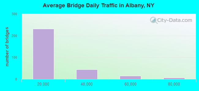
- 4,524,777Total average daily traffic
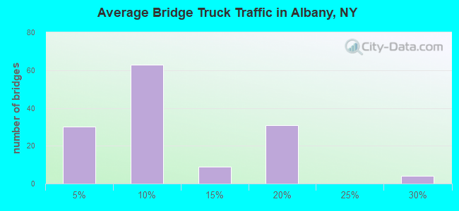
- 184,101Total average daily truck traffic
- National Bridge Inventory (NBI) Registered Bridges for Albany
- No street view available for this location
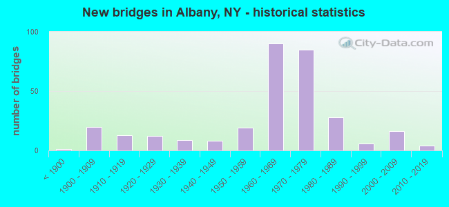
- New bridges - historical statistics
- 1Before 1900
- 201900-1909
- 131910-1919
- 121920-1929
- 91930-1939
- 81940-1949
- 191950-1959
- 901960-1969
- 851970-1979
- 281980-1989
- 61990-1999
- 162000-2009
- 42010-2019
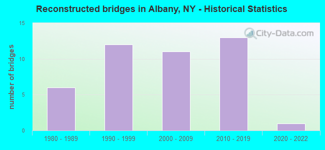
- Reconstructed bridges - Historical Statistics
- 61980-1989
- 121990-1999
- 112000-2009
- 132010-2019
- 12020-2022
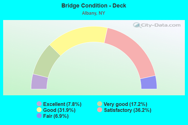
- Bridge Condition - Deck
- 7.8%Excellent
- 17.2%Very good
- 31.9%Good
- 36.2%Satisfactory
- 6.9%Fair
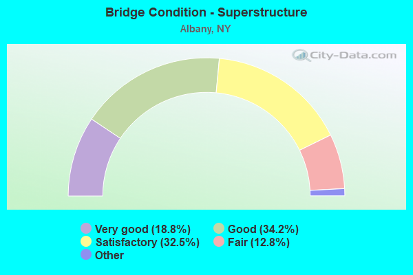
- Bridge Condition - Superstructure
- 18.8%Excellent
- 34.2%Very good
- 32.5%Good
- 12.8%Satisfactory
- 1.7%Fair
- 0.9%Poor
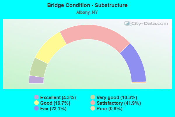
- Bridge Condition - Substructure
- 4.3%Excellent
- 10.3%Very good
- 19.7%Good
- 41.9%Satisfactory
- 23.1%Fair
- 0.9%Poor
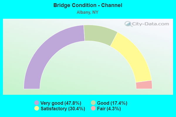
- Bridge Condition - Channel
- 47.8%Very good
- 17.4%Good
- 30.4%Satisfactory
- 4.3%Fair
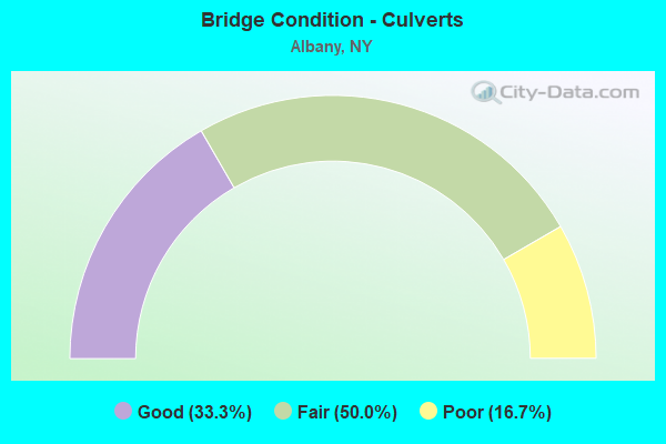
- Bridge Condition - Culverts
- 33.3%Good
- 50.0%Fair
- 16.7%Poor
Find on map >> Show street view
Structure Number: 1092839, Location: JCT I90 & HUDSON RIVER (Lat: 42.664383, Lng: -73.728089), Route carried "on" structure: Interstate 90, Year Built: 1968, Year Reconstructed: 2016, Status: Open, Structure Length: 54.77m (179.69ft), Average Daily Traffic: 58,411 (year 2019), Truck Traffic: 7%, Average Future Daily Traffic: 92,563 (year 2040), Design Load: HS 20, Features Intersected: Mohawk-Hudson Bike-Hike,
Minimum Vertical Clearance: 30+ m (98+ ft), Kilometerpoint: 0.000, Lanes on structure: 4, Base Highway Network: Yes, Owner: State Highway Agency, Approaching Roadway Width: 24.7m (81.0ft), Skew: 20 degrees, Navigation Control: Yes ( Vertical Clearance: 18.2m (59.7ft), Horizontal Clearance: 91.4m (299.9ft)), Material/Design: Steel, Design/Construction: Truss - Deck, Number Of Spans In Main Unit: 7, Number Of Approach Spans: 3, Length of Maximum Span: 114.3m (375.0ft), Curb-To-Curb Width: 24.7m (81.0ft), Out-to-Out Width: 27.2m (89.2ft)
Condition: Deck: Very good, Superstructure: Fair, Substructure: Good, Channel: Good, Operating Rating: 52.6 metric tons, Method Used To Determine Operating Rating: Load Factor (LF), Inventory Rating: 24.5 metric tons, Method Used To Determine Inventory Rating: Load Factor (LF), Structural Evaluation: Somewhat better than minimum adequacy, Deck Geometry: Superior to present desirable criteria, Underclear: Better than present minimum criteria, Waterway Adequacy: Superior to present desirable criteria, Approach Roadway Alignment: Equal to present desirable criteria, Length Of Structure Improvement: 54.77m (179.69ft), Designated Inspection Frequency: Every 24 months, Critical Feature Inspection Frequency: Every 12 months, Underwater Inspection Frequency: Every 60 months, Inspection Date: September 2020, Critical Feature Inspection Date: September 2020, Underwater Inspection Date: August 2017, Bridge Improvement Cost: $89,038,000, Roadway Improvement Cost: $52,141,000, Total Project Cost: $141,179,000 ( Estimate for 2021), Deck Structure Type: Concrete Precast Panels, Wearing Surface/Protective System: Wearing Surface: Integral Concrete
Find on map >> Show street view
Structure Number: 109283A, Location: JCT I90 & HUDSON RIVER (Lat: 42.666092, Lng: -73.730569), Route carried "on" structure: Ramp Interstate 90, Year Built: 1968, Year Reconstructed: 2015, Status: Open, Structure Length: 6.80m (22.31ft), Truck Traffic: 18%, Design Load: HS 20, Features Intersected: HUDSON RIVER BANK
Minimum Vertical Clearance: 30+ m (98+ ft), Kilometerpoint: 0.145, Lanes on structure: 2, Owner: State Highway Agency, Approaching Roadway Width: 8.8m (28.9ft), Skew: 2 degrees, Material/Design: Steel, Design/Construction: Girder and Floorbeam System, Number Of Spans In Main Unit: 2, Length of Maximum Span: 33.5m (109.9ft), Curb-To-Curb Width: 9.2m (30.2ft), Out-to-Out Width: 10.1m (33.1ft)
Condition: Deck: Excellent, Superstructure: Very good, Substructure: Very good, Operating Rating: 50.8 metric tons, Method Used To Determine Operating Rating: Load Factor (LF), Inventory Rating: 30.8 metric tons, Method Used To Determine Inventory Rating: Load Factor (LF), Structural Evaluation: Better than present minimum criteria, Deck Geometry: Somewhat better than minimum adequacy, Approach Roadway Alignment: Equal to present desirable criteria, Length Of Structure Improvement: 6.79m (22.28ft), Designated Inspection Frequency: Every 24 months, Critical Feature Inspection Frequency: Every 24 months, Inspection Date: July 2020, Critical Feature Inspection Date: July 2020, Bridge Improvement Cost: $1,460,000, Roadway Improvement Cost: $855,000, Total Project Cost: $2,315,000 ( Estimate for 2021), Deck Structure Type: Other, Wearing Surface/Protective System: Wearing Surface: Integral Concrete
Find on map >> Show street view
Structure Number: 109283B, Location: JCT I90 & HUDSON RIVER (Lat: 42.665775, Lng: -73.730928), Route carried "on" structure: Ramp Interstate 90, Year Built: 1968, Year Reconstructed: 2015, Status: Open, Structure Length: 6.80m (22.31ft), Average Daily Traffic: 13,680 (year 2017), Truck Traffic: 10%, Average Future Daily Traffic: 21,678 (year 2040), Design Load: HS 20, Features Intersected: HUDSON RIVER BANK
Minimum Vertical Clearance: 30+ m (98+ ft), Kilometerpoint: 1.255, Lanes on structure: 2, Owner: State Highway Agency, Approaching Roadway Width: 9.1m (29.9ft), Skew: 2 degrees, Material/Design: Steel, Design/Construction: Girder and Floorbeam System, Number Of Spans In Main Unit: 2, Length of Maximum Span: 33.5m (109.9ft), Curb-To-Curb Width: 9.2m (30.2ft), Out-to-Out Width: 10.1m (33.1ft)
Condition: Deck: Excellent, Superstructure: Good, Substructure: Good, Operating Rating: 50.8 metric tons, Method Used To Determine Operating Rating: Load Factor (LF), Inventory Rating: 30.8 metric tons, Method Used To Determine Inventory Rating: Load Factor (LF), Structural Evaluation: Better than present minimum criteria, Deck Geometry: Somewhat better than minimum adequacy, Approach Roadway Alignment: Equal to present desirable criteria, Length Of Structure Improvement: 6.79m (22.28ft), Designated Inspection Frequency: Every 24 months, Critical Feature Inspection Frequency: Every 24 months, Inspection Date: July 2020, Critical Feature Inspection Date: July 2020, Bridge Improvement Cost: $1,480,000, Roadway Improvement Cost: $867,000, Total Project Cost: $2,346,000 ( Estimate for 2021), Deck Structure Type: Other, Wearing Surface/Protective System: Wearing Surface: Latex Concrete
Find on map >> Show street view
Structure Number: 109284, Location: .1 MI W JCT I90 & SH 85 (Lat: 42.687061, Lng: -73.803886), Route carried "on" structure: Ramp Interstate , Year Built: 1967, Status: Open, Structure Length: 0.76m (2.49ft), Average Daily Traffic: 6,661 (year 2018), Truck Traffic: 18%, Average Future Daily Traffic: 10,555 (year 2040), Design Load: HS 20, Features Intersected: PATROON CREEK, Facility Carried by Structure: SH 85 SB
Minimum Vertical Clearance: 30+ m (98+ ft), Kilometerpoint: 0.531, Lanes on structure: 2, Owner: State Highway Agency, Approaching Roadway Width: 13.1m (43.0ft), Skew: 4 degrees, Material/Design: Steel, Design/Construction: Culvert, Number Of Spans In Main Unit: 2, Length of Maximum Span: 2.7m (8.9ft)
Condition: Channel: Satisfactory, Culverts: Fair, Operating Rating: 73.7 metric tons, Method Used To Determine Operating Rating: Field evaluation and documented engineering judgment, Inventory Rating: 19.6 metric tons, Method Used To Determine Inventory Rating: Field evaluation and documented engineering judgment, Structural Evaluation: Meets minimum limits, Waterway Adequacy: Superior to present desirable criteria, Approach Roadway Alignment: Equal to present desirable criteria, Length Of Structure Improvement: 0.76m (2.49ft), Designated Inspection Frequency: Every 24 months, Inspection Date: May 2020, Bridge Improvement Cost: $176,000, Roadway Improvement Cost: $103,000, Total Project Cost: $279,000 ( Estimate for 2021), Wearing Surface/Protective System: Wearing Surface: Monolithic Concrete
Find on map >> Show street view
Structure Number: 109285, Location: .1 MI E JCT I90 & SH 85 (Lat: 42.687053, Lng: -73.802953), Route carried "on" structure: Ramp Interstate , Year Built: 1967, Status: Open, Structure Length: 0.67m (2.20ft), Average Daily Traffic: 12,164 (year 2018), Truck Traffic: 9%, Average Future Daily Traffic: 14,405 (year 2039), Design Load: H 20, Features Intersected: PATROON CREEK, Facility Carried by Structure: SH 85 NB
Minimum Vertical Clearance: 30+ m (98+ ft), Kilometerpoint: 0.032, Lanes on structure: 1, Owner: State Highway Agency, Approaching Roadway Width: 12.2m (40.0ft), Skew: 4 degrees, Material/Design: Steel, Design/Construction: Culvert, Number Of Spans In Main Unit: 2, Length of Maximum Span: 2.7m (8.9ft)
Condition: Channel: Satisfactory, Culverts: Fair, Operating Rating: 71.2 metric tons, Method Used To Determine Operating Rating: Field evaluation and documented engineering judgment, Inventory Rating: 19.6 metric tons, Method Used To Determine Inventory Rating: Field evaluation and documented engineering judgment, Structural Evaluation: Meets minimum limits, Waterway Adequacy: Superior to present desirable criteria, Approach Roadway Alignment: Better than present minimum criteria, Length Of Structure Improvement: 0.67m (2.20ft), Designated Inspection Frequency: Every 24 months, Inspection Date: May 2020, Bridge Improvement Cost: $144,000, Roadway Improvement Cost: $84,000, Total Project Cost: $229,000 ( Estimate for 2021), Wearing Surface/Protective System: Wearing Surface: Monolithic Concrete
Find on map >> Show street view
Structure Number: 109286, Location: .3 MI W JCT I90 & US 5 (Lat: 42.687222, Lng: -73.801822), Route carried "on" structure: Ramp Interstate , Year Built: 1967, Status: Open, Structure Length: 0.70m (2.30ft), Average Daily Traffic: 8,443 (year 2018), Truck Traffic: 18%, Average Future Daily Traffic: 13,379 (year 2040), Design Load: HS 20, Features Intersected: PATROON CREEK, Facility Carried by Structure: SH 85 NB TO I90WB
Minimum Vertical Clearance: 30+ m (98+ ft), Kilometerpoint: 0.257, Lanes on structure: 1, Owner: State Highway Agency, Approaching Roadway Width: 9.4m (30.8ft), Skew: 4 degrees, Material/Design: Steel, Design/Construction: Culvert, Number Of Spans In Main Unit: 2, Length of Maximum Span: 3.0m (9.8ft)
Condition: Channel: Satisfactory, Culverts: Good, Operating Rating: 74.8 metric tons, Method Used To Determine Operating Rating: Field evaluation and documented engineering judgment, Inventory Rating: 32.7 metric tons, Method Used To Determine Inventory Rating: Field evaluation and documented engineering judgment, Structural Evaluation: Better than present minimum criteria, Waterway Adequacy: Superior to present desirable criteria, Approach Roadway Alignment: Equal to present desirable criteria, Length Of Structure Improvement: 0.70m (2.30ft), Designated Inspection Frequency: Every 24 months, Inspection Date: May 2020, Bridge Improvement Cost: $117,000, Roadway Improvement Cost: $68,000, Total Project Cost: $185,000 ( Estimate for 2021), Wearing Surface/Protective System: Wearing Surface: Bituminous
Find on map >> Show street view
Structure Number: 109287, Location: .2 MI W JCT I90 & US 5 (Lat: 42.687397, Lng: -73.801097), Route carried "on" structure: Ramp Interstate , Year Built: 1967, Status: Open, Structure Length: 0.64m (2.10ft), Average Daily Traffic: 6,661 (year 2018), Truck Traffic: 18%, Average Future Daily Traffic: 10,555 (year 2040), Design Load: H 20, Features Intersected: PATROON CREEK, Facility Carried by Structure: I90WB TO SH 85 SB
Minimum Vertical Clearance: 30+ m (98+ ft), Kilometerpoint: 0.161, Lanes on structure: 2, Owner: State Highway Agency, Approaching Roadway Width: 12.8m (42.0ft), Skew: 4 degrees, Material/Design: Steel, Design/Construction: Culvert, Number Of Spans In Main Unit: 2, Length of Maximum Span: 2.7m (8.9ft)
Condition: Channel: Satisfactory, Culverts: Poor, Operating Rating: 71.8 metric tons, Method Used To Determine Operating Rating: Field evaluation and documented engineering judgment, Inventory Rating: 29.4 metric tons, Method Used To Determine Inventory Rating: Field evaluation and documented engineering judgment, Structural Evaluation: Meets minimum limits, Waterway Adequacy: Superior to present desirable criteria, Approach Roadway Alignment: Equal to present desirable criteria, Length Of Structure Improvement: 0.64m (2.10ft), Designated Inspection Frequency: Every 24 months, Inspection Date: April 2021, Bridge Improvement Cost: $145,000, Roadway Improvement Cost: $85,000, Total Project Cost: $229,000 ( Estimate for 2021)
Find on map >> Show street view
Structure Number: 1092881, Location: JCT I787 & CSX RR/ AMTRA (Lat: 42.655381, Lng: -73.744375), Route carried "on" structure: Interstate 787, Year Built: 1970, Year Reconstructed: 2014, Status: Open, Structure Length: 66.78m (219.09ft), Average Daily Traffic: 42,071 (year 2011), Truck Traffic: 10%, Average Future Daily Traffic: 58,899 (year 2031), Design Load: HS 20, Features Intersected: ROUTE 9 RAMP TO CLINTON,
Minimum Vertical Clearance: 5.31m (17.42ft), Kilometerpoint: 3.910, Lanes on structure: 4, Lanes under structure: 4, Base Highway Network: Yes, Owner: State Highway Agency, Approaching Roadway Width: 18.2m (59.7ft), Material/Design: Steel, Design/Construction: Stringer/Multi-beam, Number Of Spans In Main Unit: 18, Length of Maximum Span: 37.4m (122.7ft), Curb-To-Curb Width: 18.2m (59.7ft), Out-to-Out Width: 19.1m (62.7ft)
Condition: Deck: Good, Superstructure: Good, Substructure: Good, Operating Rating: 92.5 metric tons, Method Used To Determine Operating Rating: Load Factor (LF), Inventory Rating: 55.3 metric tons, Method Used To Determine Inventory Rating: Load Factor (LF), Structural Evaluation: Better than present minimum criteria, Deck Geometry: Meets minimum limits, Underclear: High priority of corrective action, Approach Roadway Alignment: Equal to present desirable criteria, Length Of Structure Improvement: 66.78m (219.09ft), Designated Inspection Frequency: Every 24 months, Critical Feature Inspection Frequency: Every 24 months, Inspection Date: November 2020, Critical Feature Inspection Date: November 2020, Bridge Improvement Cost: $25,289,000, Roadway Improvement Cost: $14,809,000, Total Project Cost: $40,099,000 ( Estimate for 2021), Deck Structure Type: Concrete Cast-file-Place, Wearing Surface/Protective System: Wearing Surface: Monolithic Concrete
Find on map >> Show street view
Structure Number: 1092882, Location: JCT I787 & CONRAIL/AMTRAK (Lat: 42.655275, Lng: -73.744228), Route carried "on" structure: Interstate 787, Year Built: 1970, Year Reconstructed: 2014, Status: Open, Structure Length: 66.51m (218.21ft), Average Daily Traffic: 31,370 (year 2019), Truck Traffic: 7%, Average Future Daily Traffic: 49,712 (year 2040), Design Load: HS 20, Features Intersected: ROUTE 9 RAMP TO CLINTON,
Minimum Vertical Clearance: 4.90m (16.08ft), Kilometerpoint: 3.910, Lanes on structure: 4, Lanes under structure: 4, Base Highway Network: Yes, Owner: State Highway Agency, Approaching Roadway Width: 18.3m (60.0ft), Material/Design: Steel, Design/Construction: Stringer/Multi-beam, Number Of Spans In Main Unit: 18, Length of Maximum Span: 37.4m (122.7ft), Curb-To-Curb Width: 19.0m (62.3ft), Out-to-Out Width: 20.5m (67.3ft)
Condition: Deck: Good, Superstructure: Good, Substructure: Good, Operating Rating: 98.0 metric tons, Method Used To Determine Operating Rating: Load Factor (LF), Inventory Rating: 58.1 metric tons, Method Used To Determine Inventory Rating: Load Factor (LF), Structural Evaluation: Better than present minimum criteria, Deck Geometry: Meets minimum limits, Underclear: High priority of corrective action, Approach Roadway Alignment: Equal to present desirable criteria, Length Of Structure Improvement: 66.50m (218.18ft), Designated Inspection Frequency: Every 24 months, Inspection Date: November 2020, Bridge Improvement Cost: $27,073,000, Roadway Improvement Cost: $15,854,000, Total Project Cost: $42,928,000 ( Estimate for 2021), Deck Structure Type: Concrete Cast-file-Place, Wearing Surface/Protective System: Wearing Surface: Monolithic Concrete
Find on map >> Show street view
Structure Number: 109288A, Location: JCT I787 & MONTGOMERY ST (Lat: 42.654678, Lng: -73.745631), Route carried "on" structure: Ramp Interstate , Year Built: 1970, Status: Open, Structure Length: 26.09m (85.60ft), Average Daily Traffic: 1,328 (year 2010), Truck Traffic: 18%, Average Future Daily Traffic: 2,104 (year 2040), Design Load: HS 20, Features Intersected: WATER ST, D & H R.R., Facility Carried by Structure: RAMP I787 SB to Cl
Minimum Vertical Clearance: 32.69m (107.25ft), Kilometerpoint: 0.354, Lanes on structure: 1, Lanes under structure: 2, Owner: State Highway Agency, Approaching Roadway Width: 15.2m (49.9ft), Skew: 2 degrees, Material/Design: Steel continuous, Design/Construction: Stringer/Multi-beam, Number Of Spans In Main Unit: 7, Length of Maximum Span: 55.1m (180.8ft), Curb-To-Curb Width: 7.3m (24.0ft), Out-to-Out Width: 8.4m (27.6ft)
Condition: Deck: Good, Superstructure: Satisfactory, Substructure: Satisfactory, Operating Rating: 52.6 metric tons, Method Used To Determine Operating Rating: Load Factor (LF), Inventory Rating: 31.8 metric tons, Method Used To Determine Inventory Rating: Load Factor (LF), Structural Evaluation: Equal to present minimum criteria, Deck Geometry: Better than present minimum criteria, Underclear: High priority of corrective action, Approach Roadway Alignment: Equal to present desirable criteria, Length Of Structure Improvement: 26.09m (85.60ft), Designated Inspection Frequency: Every 24 months, Inspection Date: December 2021, Bridge Improvement Cost: $3,654,000, Roadway Improvement Cost: $2,140,000, Total Project Cost: $5,794,000 ( Estimate for 2021), Deck Structure Type: Concrete Cast-file-Place, Wearing Surface/Protective System: Wearing Surface: Monolithic Concrete
Find on map >> Show street view
Structure Number: 109288B, Location: I787 NB OFF CLINTON AVE (Lat: 42.655419, Lng: -73.744928), Route carried "on" structure: Interstate 9, Year Built: 1970, Status: Open, Structure Length: 27.01m (88.62ft), Average Daily Traffic: 2,736 (year 2020), Truck Traffic: 3%, Average Future Daily Traffic: 3,170 (year 2040), Design Load: HS 20, Features Intersected: WATER STREET, DELAWARE &
Minimum Vertical Clearance: 30+ m (98+ ft), Kilometerpoint: 1.448, Lanes on structure: 1, Lanes under structure: 2, Base Highway Network: Yes, Owner: State Highway Agency, Approaching Roadway Width: 5.5m (18.0ft), Skew: 2 degrees, Material/Design: Steel, Design/Construction: Stringer/Multi-beam, Number Of Spans In Main Unit: 7, Length of Maximum Span: 44.8m (147.0ft), Curb-To-Curb Width: 5.5m (18.0ft), Out-to-Out Width: 6.4m (21.0ft)
Condition: Deck: Good, Superstructure: Satisfactory, Substructure: Satisfactory, Operating Rating: 94.7 metric tons, Method Used To Determine Operating Rating: Field evaluation and documented engineering judgment, Inventory Rating: 29.4 metric tons, Method Used To Determine Inventory Rating: Field evaluation and documented engineering judgment, Structural Evaluation: Equal to present minimum criteria, Deck Geometry: High priority of replacement, Underclear: High priority of corrective action, Approach Roadway Alignment: Equal to present desirable criteria, Length Of Structure Improvement: 27.00m (88.58ft), Designated Inspection Frequency: Every 24 months, Inspection Date: August 2020, Bridge Improvement Cost: $3,500,000, Roadway Improvement Cost: $2,050,000, Total Project Cost: $5,550,000 ( Estimate for 2021), Deck Structure Type: Concrete Cast-file-Place, Wearing Surface/Protective System: Wearing Surface: Monolithic Concrete
Find on map >> Show street view
Structure Number: 109288C, Location: JCT ORANGE ST & I787 NB (Lat: 42.653272, Lng: -73.746111), Route carried "on" structure: Ramp Interstate , Year Built: 1970, Status: Open, Structure Length: 52.40m (171.92ft), Average Daily Traffic: 9,750 (year 2010), Truck Traffic: 18%, Average Future Daily Traffic: 15,450 (year 2040), Design Load: H 20, Features Intersected: US 9, 787IX SB, WATER ST, Facility Carried by Structure: CLINT AVE TO I787
Minimum Vertical Clearance: 5.71m (18.73ft), Kilometerpoint: 0.048, Lanes on structure: 2, Lanes under structure: 14, Owner: State Highway Agency, Approaching Roadway Width: 15.2m (49.9ft), Material/Design: Steel, Design/Construction: Stringer/Multi-beam, Number Of Spans In Main Unit: 14, Length of Maximum Span: 53.3m (174.9ft), Curb-To-Curb Width: 7.3m (24.0ft), Out-to-Out Width: 8.4m (27.6ft)
Condition: Deck: Satisfactory, Superstructure: Satisfactory, Substructure: Satisfactory, Operating Rating: 83.2 metric tons, Method Used To Determine Operating Rating: Field evaluation and documented engineering judgment, Inventory Rating: 29.4 metric tons, Method Used To Determine Inventory Rating: Field evaluation and documented engineering judgment, Structural Evaluation: Equal to present minimum criteria, Deck Geometry: High priority of replacement, Underclear: High priority of corrective action, Approach Roadway Alignment: Equal to present desirable criteria, Length Of Structure Improvement: 52.39m (171.88ft), Designated Inspection Frequency: Every 24 months, Inspection Date: November 2020, Bridge Improvement Cost: $8,597,000, Roadway Improvement Cost: $5,034,000, Total Project Cost: $13,631,000 ( Estimate for 2021), Deck Structure Type: Concrete Cast-file-Place, Wearing Surface/Protective System: Wearing Surface: Monolithic Concrete
Find on map >> Show street view
Structure Number: 109288D, Location: JCT ORANGE ST & I787 SB (Lat: 42.652486, Lng: -73.747578), Route carried "on" structure: Ramp Interstate , Year Built: 1970, Status: Open, Structure Length: 17.28m (56.69ft), Average Daily Traffic: 79,759 (year 1989), Truck Traffic: 9%, Average Future Daily Traffic: 111,663 (year 2009), Design Load: H 20, Features Intersected: WATER STREET, Facility Carried by Structure: CLINTON AVE RAMP
Minimum Vertical Clearance: 30+ m (98+ ft), Kilometerpoint: 4.183, Lanes on structure: 1, Lanes under structure: 2, Owner: State Highway Agency, Approaching Roadway Width: 7.9m (25.9ft), Skew: 2 degrees, Material/Design: Steel, Design/Construction: Stringer/Multi-beam, Number Of Spans In Main Unit: 5, Length of Maximum Span: 34.7m (113.8ft), Curb-To-Curb Width: 7.9m (25.9ft), Out-to-Out Width: 9.0m (29.5ft)
Condition: Deck: Satisfactory, Superstructure: Good, Substructure: Satisfactory, Operating Rating: 77.7 metric tons, Method Used To Determine Operating Rating: Field evaluation and documented engineering judgment, Inventory Rating: 28.5 metric tons, Method Used To Determine Inventory Rating: Field evaluation and documented engineering judgment, Structural Evaluation: Equal to present minimum criteria, Deck Geometry: Equal to present desirable criteria, Underclear: High priority of corrective action, Approach Roadway Alignment: Equal to present desirable criteria, Length Of Structure Improvement: 17.28m (56.69ft), Designated Inspection Frequency: Every 24 months, Inspection Date: September 2020, Bridge Improvement Cost: $3,133,000, Roadway Improvement Cost: $1,835,000, Total Project Cost: $4,968,000 ( Estimate for 2021), Deck Structure Type: Concrete Cast-file-Place, Wearing Surface/Protective System: Wearing Surface: Monolithic Concrete
Find on map >> Show street view
Structure Number: 109292, Location: 1.1 MI S JCT I90 & I787 (Lat: 42.654208, Lng: -73.746053), Route carried "on" structure: Ramp Interstate , Year Built: 1970, Status: Open, Structure Length: 21.88m (71.78ft), Average Daily Traffic: 2,920 (year 2010), Truck Traffic: 5%, Average Future Daily Traffic: 4,088 (year 2030), Design Load: H 20, Features Intersected: I787SB TO CLINTON, ORANG, Facility Carried by Structure: WATER STREET
Minimum Vertical Clearance: 5.30m (17.39ft), Kilometerpoint: 0.499, Lanes on structure: 2, Owner: State Highway Agency, Approaching Roadway Width: 9.1m (29.9ft), Material/Design: Steel, Design/Construction: Stringer/Multi-beam, Number Of Spans In Main Unit: 6, Length of Maximum Span: 41.4m (135.8ft), Curb or Sidewalk Widths: Left: 1.5m (4.9ft), Right: 0.0m, Curb-To-Curb Width: 8.9m (29.2ft), Out-to-Out Width: 10.5m (34.4ft)
Condition: Deck: Satisfactory, Superstructure: Satisfactory, Substructure: Fair, Operating Rating: 59.9 metric tons, Method Used To Determine Operating Rating: Load Factor (LF), Inventory Rating: 29.9 metric tons, Method Used To Determine Inventory Rating: Load Factor (LF), Structural Evaluation: Somewhat better than minimum adequacy, Deck Geometry: Meets minimum limits, Underclear: Meets minimum limits, Approach Roadway Alignment: Equal to present desirable criteria, Length Of Structure Improvement: 21.88m (71.78ft), Designated Inspection Frequency: Every 24 months, Inspection Date: September 2021, Bridge Improvement Cost: $4,798,000, Roadway Improvement Cost: $2,810,000, Total Project Cost: $7,608,000 ( Estimate for 2021), Deck Structure Type: Concrete Cast-file-Place, Wearing Surface/Protective System: Wearing Surface: Integral Concrete
Find on map >> Show street view
Structure Number: 109294, Location: NB RMP US9 & 20 O/HDSN RV (Lat: 42.644286, Lng: -73.749411), Route carried "on" structure: Ramp Interstate 9, Year Built: 1972, Status: Open, Structure Length: 39.96m (131.10ft), Average Daily Traffic: 12,483 (year 2020), Truck Traffic: 8%, Average Future Daily Traffic: 14,465 (year 2040), Design Load: H 20, Features Intersected: QUAY STREET, S MALL-EB t
Minimum Vertical Clearance: 6.76m (22.18ft), Kilometerpoint: 0.129, Lanes on structure: 2, Lanes under structure: 9, Base Highway Network: Yes, Owner: State Highway Agency, Approaching Roadway Width: 9.4m (30.8ft), Skew: 32 degrees, Navigation Control: Yes ( Vertical Clearance: 999.9m (3,280.5ft), Horizontal Clearance: 91.4m (299.9ft)), Material/Design: Steel, Design/Construction: Stringer/Multi-beam, Number Of Spans In Main Unit: 11, Length of Maximum Span: 45.1m (148.0ft), Curb or Sidewalk Widths: Left: 0.6m (2.0ft), Right: 2.4m (7.9ft), Curb-To-Curb Width: 9.4m (30.8ft), Out-to-Out Width: 13.7m (44.9ft)
Condition: Deck: Satisfactory, Superstructure: Fair, Substructure: Satisfactory, Channel: Satisfactory, Operating Rating: 83.0 metric tons, Method Used To Determine Operating Rating: Field evaluation and documented engineering judgment, Inventory Rating: 29.4 metric tons, Method Used To Determine Inventory Rating: Field evaluation and documented engineering judgment, Structural Evaluation: Somewhat better than minimum adequacy, Deck Geometry: Somewhat better than minimum adequacy, Underclear: High priority of corrective action, Waterway Adequacy: Equal to present desirable criteria, Approach Roadway Alignment: Equal to present desirable criteria, Length Of Structure Improvement: 39.95m (131.07ft), Designated Inspection Frequency: Every 24 months, Underwater Inspection Frequency: Every 60 months, Inspection Date: November 2021, Underwater Inspection Date: October 2018, Bridge Improvement Cost: $12,484,000, Roadway Improvement Cost: $7,310,000, Total Project Cost: $19,794,000 ( Estimate for 2021), Deck Structure Type: Concrete Cast-file-Place, Wearing Surface/Protective System: Wearing Surface: Monolithic Concrete
Find on map >> Show street view
Structure Number: 109294A, Location: DOWNTOWN ALBANY (Lat: 42.644433, Lng: -73.749914), Route carried "on" structure: Ramp Interstate , Year Built: 1973, Status: Open, Structure Length: 56.39m (185.01ft), Average Daily Traffic: 3,391 (year 2020), Truck Traffic: 5%, Average Future Daily Traffic: 5,373 (year 2040), Design Load: H 20, Features Intersected: 787I 787I 1101 1019 SB,, Facility Carried by Structure: DUNN WB TO I787 SB
Minimum Vertical Clearance: 5.13m (16.83ft), Kilometerpoint: 0.000, Lanes on structure: 1, Lanes under structure: 32, Owner: State Highway Agency, Approaching Roadway Width: 6.7m (22.0ft), Skew: 20 degrees, Material/Design: Steel, Design/Construction: Stringer/Multi-beam, Number Of Spans In Main Unit: 17, Length of Maximum Span: 41.1m (134.8ft), Curb or Sidewalk Widths: Left: 0.6m (2.0ft), Right: 0.6m (2.0ft), Curb-To-Curb Width: 6.7m (22.0ft), Out-to-Out Width: 8.7m (28.5ft)
Condition: Deck: Good, Superstructure: Satisfactory, Substructure: Satisfactory, Operating Rating: 61.7 metric tons, Method Used To Determine Operating Rating: Load Factor (LF), Inventory Rating: 37.2 metric tons, Method Used To Determine Inventory Rating: Load Factor (LF), Structural Evaluation: Equal to present minimum criteria, Deck Geometry: High priority of corrective action, Underclear: High priority of corrective action, Approach Roadway Alignment: Equal to present desirable criteria, Length Of Structure Improvement: 56.38m (184.97ft), Designated Inspection Frequency: Every 24 months, Inspection Date: October 2021, Bridge Improvement Cost: $10,188,000, Roadway Improvement Cost: $5,966,000, Total Project Cost: $16,154,000 ( Estimate for 2021), Deck Structure Type: Concrete Cast-file-Place, Wearing Surface/Protective System: Wearing Surface: Monolithic Concrete
Find on map >> Show street view
Structure Number: 1092951, Location: I787 & BWAY-QUAY ST CONN (Lat: 42.646272, Lng: -73.749153), Route carried "on" structure: Interstate 787, Year Built: 1973, Status: Open, Structure Length: 2.26m (7.41ft), Truck Traffic: 9%, Design Load: H 20, Features Intersected: BWAY-QUAY ST CONN
Minimum Vertical Clearance: 30+ m (98+ ft), Kilometerpoint: 3.154, Lanes on structure: 4, Lanes under structure: 4, Base Highway Network: Yes, Owner: State Highway Agency, Approaching Roadway Width: 16.5m (54.1ft), Material/Design: Steel, Design/Construction: Stringer/Multi-beam, Number Of Spans In Main Unit: 1, Length of Maximum Span: 21.3m (69.9ft), Curb-To-Curb Width: 16.4m (53.8ft), Out-to-Out Width: 17.4m (57.1ft)
Condition: Deck: Very good, Superstructure: Satisfactory, Substructure: Good, Inventory Rating: 64.4 metric tons, Method Used To Determine Inventory Rating: Load Factor (LF), Structural Evaluation: Equal to present minimum criteria, Deck Geometry: High priority of replacement, Underclear: Equal to present minimum criteria, Approach Roadway Alignment: Equal to present desirable criteria, Length Of Structure Improvement: 2.25m (7.38ft), Designated Inspection Frequency: Every 24 months, Inspection Date: August 2021, Bridge Improvement Cost: $1,640,000, Roadway Improvement Cost: $961,000, Total Project Cost: $2,601,000 ( Estimate for 2021), Deck Structure Type: Concrete Cast-file-Place, Wearing Surface/Protective System: Wearing Surface: Monolithic Concrete
Find on map >> Show street view
Structure Number: 1092952, Location: I787 & BWAY-QUAY ST CONN (Lat: 42.646197, Lng: -73.748847), Route carried "on" structure: Interstate 787, Year Built: 1973, Status: Open, Structure Length: 2.29m (7.51ft), Average Daily Traffic: 14,568 (year 2019), Truck Traffic: 7%, Average Future Daily Traffic: 23,085 (year 2040), Design Load: H 20, Features Intersected: BWAY-QUAY ST CONN
Minimum Vertical Clearance: 30+ m (98+ ft), Kilometerpoint: 3.154, Lanes on structure: 4, Lanes under structure: 4, Base Highway Network: Yes, Owner: State Highway Agency, Approaching Roadway Width: 12.8m (42.0ft), Material/Design: Steel, Design/Construction: Stringer/Multi-beam, Number Of Spans In Main Unit: 1, Length of Maximum Span: 21.6m (70.9ft), Curb-To-Curb Width: 16.2m (53.1ft), Out-to-Out Width: 18.3m (60.0ft)
Condition: Deck: Very good, Superstructure: Good, Substructure: Satisfactory, Operating Rating: 94.3 metric tons, Method Used To Determine Operating Rating: Load Factor (LF), Inventory Rating: 56.2 metric tons, Method Used To Determine Inventory Rating: Load Factor (LF), Structural Evaluation: Equal to present minimum criteria, Deck Geometry: High priority of replacement, Underclear: Equal to present minimum criteria, Approach Roadway Alignment: Equal to present desirable criteria, Length Of Structure Improvement: 2.28m (7.48ft), Designated Inspection Frequency: Every 24 months, Inspection Date: August 2021, Bridge Improvement Cost: $1,716,000, Roadway Improvement Cost: $1,005,000, Total Project Cost: $2,721,000 ( Estimate for 2021), Deck Structure Type: Concrete Cast-file-Place, Wearing Surface/Protective System: Wearing Surface: Monolithic Concrete
Find on map >> Show street view
Structure Number: 109297, Location: I787 SB RAMP & BROADWAY (Lat: 42.643417, Lng: -73.751950), Route carried "on" structure: Ramp Interstate 787, Year Built: 1972, Year Reconstructed: 2016, Status: Open, Structure Length: 56.51m (185.40ft), Average Daily Traffic: 9,192 (year 2020), Truck Traffic: 18%, Average Future Daily Traffic: 9,235 (year 2040), Design Load: H 20, Features Intersected: 787I 787I 11011018 NB, B
Minimum Vertical Clearance: 5.43m (17.81ft), Kilometerpoint: 0.145, Lanes on structure: 2, Lanes under structure: 18, Owner: State Highway Agency, Approaching Roadway Width: 8.2m (26.9ft), Material/Design: Steel continuous, Design/Construction: Stringer/Multi-beam, Number Of Spans In Main Unit: 16, Length of Maximum Span: 48.8m (160.1ft), Curb or Sidewalk Widths: Left: 0.6m (2.0ft), Right: 0.6m (2.0ft), Curb-To-Curb Width: 9.2m (30.2ft), Out-to-Out Width: 11.2m (36.7ft)
Condition: Deck: Satisfactory, Superstructure: Satisfactory, Substructure: Fair, Operating Rating: 71.7 metric tons, Method Used To Determine Operating Rating: Load Factor (LF), Inventory Rating: 42.6 metric tons, Method Used To Determine Inventory Rating: Load Factor (LF), Structural Evaluation: Somewhat better than minimum adequacy, Deck Geometry: Somewhat better than minimum adequacy, Underclear: High priority of corrective action, Approach Roadway Alignment: Equal to present desirable criteria, Length Of Structure Improvement: 56.50m (185.37ft), Designated Inspection Frequency: Every 24 months, Inspection Date: October 2021, Bridge Improvement Cost: $13,028,000, Roadway Improvement Cost: $7,629,000, Total Project Cost: $20,657,000 ( Estimate for 2021), Deck Structure Type: Concrete Cast-file-Place, Wearing Surface/Protective System: Wearing Surface: Monolithic Concrete
Find on map >> Show street view
Structure Number: 109297A, Location: I787 58 RAMP&BDWAY-ALBANY (Lat: 42.645194, Lng: -73.751631), Route carried "on" structure: Ramp Interstate , Year Built: 1973, Status: Open, Structure Length: 25.76m (84.51ft), Average Daily Traffic: 3,252 (year 2020), Truck Traffic: 18%, Average Future Daily Traffic: 5,153 (year 2040), Design Load: H 20, Features Intersected: SM-OFF TO PEARL ST, GREE, Facility Carried by Structure: I787 SB TO SMX WB
Minimum Vertical Clearance: 30+ m (98+ ft), Kilometerpoint: 0.032, Lanes on structure: 1, Lanes under structure: 3, Owner: State Highway Agency, Approaching Roadway Width: 11.6m (38.1ft), Material/Design: Steel, Design/Construction: Stringer/Multi-beam, Number Of Spans In Main Unit: 7, Length of Maximum Span: 44.5m (146.0ft), Curb or Sidewalk Widths: Left: 0.6m (2.0ft), Right: 0.6m (2.0ft), Curb-To-Curb Width: 6.7m (22.0ft), Out-to-Out Width: 8.2m (26.9ft)
Condition: Deck: Satisfactory, Superstructure: Fair, Substructure: Satisfactory, Operating Rating: 91.9 metric tons, Method Used To Determine Operating Rating: Field evaluation and documented engineering judgment, Inventory Rating: 32.7 metric tons, Method Used To Determine Inventory Rating: Field evaluation and documented engineering judgment, Structural Evaluation: Somewhat better than minimum adequacy, Deck Geometry: Equal to present minimum criteria, Underclear: High priority of corrective action, Approach Roadway Alignment: Equal to present desirable criteria, Length Of Structure Improvement: 25.75m (84.48ft), Designated Inspection Frequency: Every 24 months, Inspection Date: August 2021, Bridge Improvement Cost: $4,496,000, Roadway Improvement Cost: $2,633,000, Total Project Cost: $7,129,000 ( Estimate for 2021), Deck Structure Type: Concrete Cast-file-Place, Wearing Surface/Protective System: Wearing Surface: Integral Concrete, Deck Protection: Epoxy Coated Reinforcing
Find on map >> Show street view
Structure Number: 1092981, Location: E.S.PLAZA RAMP & NB I787 (Lat: 42.643719, Lng: -73.749456), Route carried "on" structure: Ramp Interstate 20, Year Built: 1972, Status: Open, Structure Length: 70.41m (231.00ft), Truck Traffic: 5%, Design Load: H 20, Features Intersected: 787I787I11011011-NB, BRO
Minimum Vertical Clearance: 5.18m (16.99ft), Kilometerpoint: 26.629, Lanes on structure: 2, Lanes under structure: 27, Owner: State Highway Agency, Approaching Roadway Width: 14.5m (47.6ft), Skew: 1 degrees, Navigation Control: Yes ( Vertical Clearance: 18.3m (60.0ft), Horizontal Clearance: 91.4m (299.9ft)), Material/Design: Steel, Design/Construction: Stringer/Multi-beam, Number Of Spans In Main Unit: 21, Length of Maximum Span: 40.8m (133.9ft), Curb or Sidewalk Widths: Left: 0.6m (2.0ft), Right: 0.0m, Curb-To-Curb Width: 13.1m (43.0ft), Out-to-Out Width: 14.5m (47.6ft)
Condition: Deck: Good, Superstructure: Satisfactory, Substructure: Very good, Channel: Very good, Operating Rating: 43.5 metric tons, Method Used To Determine Operating Rating: Load Factor (LF), Inventory Rating: 26.3 metric tons, Method Used To Determine Inventory Rating: Load Factor (LF), Structural Evaluation: Equal to present minimum criteria, Deck Geometry: Equal to present minimum criteria, Underclear: High priority of corrective action, Waterway Adequacy: Equal to present minimum criteria, Approach Roadway Alignment: Equal to present desirable criteria, Length Of Structure Improvement: 70.40m (230.97ft), Designated Inspection Frequency: Every 24 months, Inspection Date: October 2021, Bridge Improvement Cost: $20,873,000, Roadway Improvement Cost: $12,223,000, Total Project Cost: $33,096,000 ( Estimate for 2021), Deck Structure Type: Concrete Cast-file-Place, Wearing Surface/Protective System: Wearing Surface: Monolithic Concrete
Find on map >> Show street view
Structure Number: 1092982, Location: E.S.PLAZA & SB I787 (Lat: 42.643639, Lng: -73.749497), Route carried "on" structure: Ramp Interstate 20, Year Built: 1972, Status: Open, Structure Length: 70.41m (231.00ft), Truck Traffic: 5%, Design Load: H 20, Features Intersected: 787I787I11011011-NB, BRO
Minimum Vertical Clearance: 4.90m (16.08ft), Kilometerpoint: 26.629, Lanes on structure: 2, Lanes under structure: 27, Owner: State Highway Agency, Approaching Roadway Width: 16.5m (54.1ft), Skew: 21 degrees, Navigation Control: Yes ( Vertical Clearance: 18.3m (60.0ft), Horizontal Clearance: 91.4m (299.9ft)), Material/Design: Steel, Design/Construction: Stringer/Multi-beam, Number Of Spans In Main Unit: 21, Length of Maximum Span: 40.8m (133.9ft), Curb or Sidewalk Widths: Left: 0.0m, Right: 0.6m (2.0ft), Curb-To-Curb Width: 13.1m (43.0ft), Out-to-Out Width: 14.5m (47.6ft)
Condition: Deck: Satisfactory, Superstructure: Satisfactory, Substructure: Fair, Channel: Very good, Operating Rating: 80.7 metric tons, Method Used To Determine Operating Rating: Load Factor (LF), Inventory Rating: 48.1 metric tons, Method Used To Determine Inventory Rating: Load Factor (LF), Structural Evaluation: Somewhat better than minimum adequacy, Deck Geometry: Somewhat better than minimum adequacy, Underclear: High priority of corrective action, Waterway Adequacy: Equal to present minimum criteria, Approach Roadway Alignment: Equal to present desirable criteria, Length Of Structure Improvement: 70.40m (230.97ft), Designated Inspection Frequency: Every 24 months, Inspection Date: October 2021, Bridge Improvement Cost: $20,873,000, Roadway Improvement Cost: $12,223,000, Total Project Cost: $33,096,000 ( Estimate for 2021), Deck Structure Type: Concrete Cast-file-Place, Wearing Surface/Protective System: Wearing Surface: Monolithic Concrete
Find on map >> Show street view
Structure Number: 109298A, Location: RAMP SO MALL EXPRESS WB (Lat: 42.645478, Lng: -73.752214), Route carried "on" structure: Ramp Interstate 20, Year Built: 1970, Status: Open, Structure Length: 21.00m (68.90ft), Average Daily Traffic: 6,919 (year 2014), Truck Traffic: 5%, Average Future Daily Traffic: 8,017 (year 2040), Design Load: H 20, Features Intersected: TO SO MALL EXP WB, GREEN
Minimum Vertical Clearance: 4.52m (14.83ft), Kilometerpoint: 26.420, Lanes on structure: 1, Base Highway Network: Yes, Owner: State Highway Agency, Approaching Roadway Width: 6.4m (21.0ft), Material/Design: Steel, Design/Construction: Stringer/Multi-beam, Number Of Spans In Main Unit: 6, Length of Maximum Span: 37.8m (124.0ft), Curb or Sidewalk Widths: Left: 0.6m (2.0ft), Right: 0.6m (2.0ft), Curb-To-Curb Width: 6.4m (21.0ft), Out-to-Out Width: 8.4m (27.6ft)
Condition: Deck: Good, Superstructure: Good, Substructure: Satisfactory, Inventory Rating: 64.4 metric tons, Method Used To Determine Inventory Rating: Load Factor (LF), Structural Evaluation: Equal to present minimum criteria, Deck Geometry: High priority of corrective action, Approach Roadway Alignment: Equal to present desirable criteria, Length Of Structure Improvement: 21.00m (68.90ft), Designated Inspection Frequency: Every 24 months, Inspection Date: July 2021, Bridge Improvement Cost: $3,495,000, Roadway Improvement Cost: $2,047,000, Total Project Cost: $5,542,000 ( Estimate for 2021), Deck Structure Type: Concrete Cast-file-Place, Wearing Surface/Protective System: Wearing Surface: Monolithic Concrete
Find on map >> Show street view
Structure Number: 109298B, Location: ON RAMP I787 SB & MADISON (Lat: 42.645369, Lng: -73.752861), Route carried "on" structure: Ramp Interstate , Year Built: 1972, Status: Open, Structure Length: 51.76m (169.82ft), Average Daily Traffic: 5,183 (year 2020), Truck Traffic: 18%, Average Future Daily Traffic: 8,213 (year 2040), Design Load: H 20, Features Intersected: BROADWAY, BROADWAY, BROA, Facility Carried by Structure: SMX EB TO 787SB
Minimum Vertical Clearance: 6.22m (20.41ft), Kilometerpoint: 0.032, Lanes on structure: 1, Lanes under structure: 13, Owner: State Highway Agency, Approaching Roadway Width: 9.1m (29.9ft), Skew: 1 degrees, Material/Design: Steel, Design/Construction: Stringer/Multi-beam, Number Of Spans In Main Unit: 15, Length of Maximum Span: 49.1m (161.1ft), Curb or Sidewalk Widths: Left: 0.6m (2.0ft), Right: 0.6m (2.0ft), Curb-To-Curb Width: 6.4m (21.0ft), Out-to-Out Width: 8.4m (27.6ft)
Condition: Deck: Satisfactory, Superstructure: Satisfactory, Substructure: Satisfactory, Operating Rating: 71.7 metric tons, Method Used To Determine Operating Rating: Load Factor (LF), Inventory Rating: 42.6 metric tons, Method Used To Determine Inventory Rating: Load Factor (LF), Structural Evaluation: Equal to present minimum criteria, Deck Geometry: Somewhat better than minimum adequacy, Underclear: High priority of corrective action, Approach Roadway Alignment: Equal to present desirable criteria, Length Of Structure Improvement: 51.75m (169.78ft), Designated Inspection Frequency: Every 24 months, Critical Feature Inspection Frequency: Every 24 months, Inspection Date: August 2021, Critical Feature Inspection Date: August 2021, Bridge Improvement Cost: $8,543,000, Roadway Improvement Cost: $5,003,000, Total Project Cost: $13,547,000 ( Estimate for 2021), Deck Structure Type: Concrete Cast-file-Place, Wearing Surface/Protective System: Wearing Surface: Integral Concrete
Find on map >> Show street view
Structure Number: 109298C, Location: SO MALL EXP OFF TO I787NB (Lat: 42.643158, Lng: -73.751294), Route carried "on" structure: Ramp Interstate , Year Built: 1973, Status: Open, Structure Length: 56.33m (184.81ft), Average Daily Traffic: 4,071 (year 2020), Truck Traffic: 18%, Average Future Daily Traffic: 6,451 (year 2040), Design Load: H 20, Features Intersected: 787I 787I 1101 1014 NB,, Facility Carried by Structure: SMX EB TO 787 NB
Minimum Vertical Clearance: 5.18m (16.99ft), Kilometerpoint: 0.000, Lanes on structure: 1, Lanes under structure: 21, Owner: State Highway Agency, Approaching Roadway Width: 9.1m (29.9ft), Material/Design: Steel, Design/Construction: Stringer/Multi-beam, Number Of Spans In Main Unit: 17, Length of Maximum Span: 42.4m (139.1ft), Curb or Sidewalk Widths: Left: 0.6m (2.0ft), Right: 0.6m (2.0ft), Curb-To-Curb Width: 6.7m (22.0ft), Out-to-Out Width: 8.7m (28.5ft)
Condition: Deck: Good, Superstructure: Good, Substructure: Satisfactory, Operating Rating: 56.2 metric tons, Method Used To Determine Operating Rating: Load Factor (LF), Inventory Rating: 33.6 metric tons, Method Used To Determine Inventory Rating: Load Factor (LF), Structural Evaluation: Equal to present minimum criteria, Deck Geometry: Equal to present minimum criteria, Underclear: High priority of corrective action, Approach Roadway Alignment: Equal to present desirable criteria, Length Of Structure Improvement: 56.32m (184.78ft), Designated Inspection Frequency: Every 24 months, Critical Feature Inspection Frequency: Every 24 months, Inspection Date: November 2021, Critical Feature Inspection Date: November 2021, Bridge Improvement Cost: $10,263,000, Roadway Improvement Cost: $6,010,000, Total Project Cost: $16,273,000 ( Estimate for 2021), Deck Structure Type: Concrete Cast-file-Place, Wearing Surface/Protective System: Wearing Surface: Integral Concrete
Find on map >> Show street view
Structure Number: 109298D, Location: ON RAMP E S PLAZA EXP EB (Lat: 42.644567, Lng: -73.751694), Route carried "on" structure: Ramp Interstate 9, Year Built: 1969, Status: Open, Structure Length: 20.67m (67.81ft), Average Daily Traffic: 6,919 (year 2014), Truck Traffic: 5%, Average Future Daily Traffic: 8,017 (year 2040), Design Load: H 20, Features Intersected: OFF-RAMP TO 787I, GREEN
Minimum Vertical Clearance: 4.39m (14.40ft), Kilometerpoint: 26.275, Lanes on structure: 1, Owner: State Highway Agency, Approaching Roadway Width: 7.9m (25.9ft), Material/Design: Steel, Design/Construction: Stringer/Multi-beam, Number Of Spans In Main Unit: 6, Length of Maximum Span: 35.7m (117.1ft), Curb or Sidewalk Widths: Left: 0.6m (2.0ft), Right: 0.6m (2.0ft), Curb-To-Curb Width: 7.9m (25.9ft), Out-to-Out Width: 9.9m (32.5ft)
Condition: Deck: Fair, Superstructure: Fair, Substructure: Satisfactory, Inventory Rating: 63.5 metric tons, Method Used To Determine Inventory Rating: Load Factor (LF), Structural Evaluation: Somewhat better than minimum adequacy, Deck Geometry: High priority of corrective action, Approach Roadway Alignment: Equal to present desirable criteria, Length Of Structure Improvement: 20.66m (67.78ft), Designated Inspection Frequency: Every 24 months, Inspection Date: July 2021, Bridge Improvement Cost: $4,082,000, Roadway Improvement Cost: $2,390,000, Total Project Cost: $6,472,000 ( Estimate for 2021), Deck Structure Type: Concrete Cast-file-Place, Wearing Surface/Protective System: Wearing Surface: Monolithic Concrete
Find on map >> Show street view
Structure Number: 1092991, Location: IN ALBANY (Lat: 42.637683, Lng: -73.755889), Route carried "on" structure: Interstate 787, Year Built: 1973, Status: Open, Structure Length: 69.43m (227.79ft), Average Daily Traffic: 32,372 (year 2011), Truck Traffic: 10%, Design Load: H 20, Features Intersected: VINE STREET, MULTI-USE T
Minimum Vertical Clearance: 5.43m (17.81ft), Kilometerpoint: 1.995, Lanes on structure: 3, Lanes under structure: 9, Base Highway Network: Yes, Owner: State Highway Agency, Approaching Roadway Width: 16.6m (54.5ft), Material/Design: Steel, Design/Construction: Stringer/Multi-beam, Number Of Spans In Main Unit: 21, Length of Maximum Span: 42.6m (139.8ft), Curb-To-Curb Width: 13.4m (44.0ft), Out-to-Out Width: 18.2m (59.7ft)
Condition: Deck: Very good, Superstructure: Satisfactory, Substructure: Fair, Operating Rating: 81.6 metric tons, Method Used To Determine Operating Rating: Load Factor (LF), Inventory Rating: 49.0 metric tons, Method Used To Determine Inventory Rating: Load Factor (LF), Structural Evaluation: Somewhat better than minimum adequacy, Deck Geometry: Meets minimum limits, Underclear: High priority of corrective action, Approach Roadway Alignment: Equal to present desirable criteria, Length Of Structure Improvement: 69.43m (227.79ft), Designated Inspection Frequency: Every 24 months, Critical Feature Inspection Frequency: Every 24 months, Inspection Date: November 2021, Critical Feature Inspection Date: November 2021, Bridge Improvement Cost: $24,793,000, Roadway Improvement Cost: $14,519,000, Total Project Cost: $39,312,000 ( Estimate for 2021), Deck Structure Type: Concrete Cast-file-Place, Wearing Surface/Protective System: Wearing Surface: Monolithic Concrete
Find on map >> Show street view
Structure Number: 1092992, Location: I787 & B:WAY - D&H RWY (Lat: 42.637536, Lng: -73.755875), Route carried "on" structure: Interstate 787, Year Built: 1973, Status: Open, Structure Length: 69.68m (228.61ft), Average Daily Traffic: 21,223 (year 2011), Truck Traffic: 18%, Average Future Daily Traffic: 33,631 (year 2040), Design Load: H 20, Features Intersected: VINE STREET, BROADWAY, D
Minimum Vertical Clearance: 6.10m (20.01ft), Kilometerpoint: 1.995, Lanes on structure: 4, Lanes under structure: 7, Base Highway Network: Yes, Owner: State Highway Agency, Approaching Roadway Width: 17.1m (56.1ft), Material/Design: Steel, Design/Construction: Stringer/Multi-beam, Number Of Spans In Main Unit: 21, Length of Maximum Span: 42.7m (140.1ft), Curb-To-Curb Width: 16.9m (55.4ft), Out-to-Out Width: 18.8m (61.7ft)
Condition: Deck: Very good, Superstructure: Satisfactory, Substructure: Fair, Operating Rating: 88.0 metric tons, Method Used To Determine Operating Rating: Load Factor (LF), Inventory Rating: 52.6 metric tons, Method Used To Determine Inventory Rating: Load Factor (LF), Structural Evaluation: Somewhat better than minimum adequacy, Deck Geometry: Meets minimum limits, Underclear: High priority of corrective action, Approach Roadway Alignment: Equal to present desirable criteria, Length Of Structure Improvement: 69.67m (228.58ft), Designated Inspection Frequency: Every 24 months, Critical Feature Inspection Frequency: Every 12 months, Inspection Date: November 2021, Critical Feature Inspection Date: November 2021, Bridge Improvement Cost: $24,941,000, Roadway Improvement Cost: $14,606,000, Total Project Cost: $39,547,000 ( Estimate for 2021), Deck Structure Type: Concrete Cast-file-Place, Wearing Surface/Protective System: Wearing Surface: Monolithic Concrete
Find on map >> Show street view
Structure Number: 109299A, Location: RAMP I787 NB - SO MALL WB (Lat: 42.643069, Lng: -73.750189), Route carried "on" structure: Bypass Interstate 787, Year Built: 1973, Year Reconstructed: 2020, Status: Open, Structure Length: 88.70m (291.01ft), Average Daily Traffic: 1,308 (year 2020), Truck Traffic: 18%, Average Future Daily Traffic: 2,072 (year 2040), Design Load: H 20, Features Intersected: SOUTH MALL EXPWAY WB, 78
Minimum Vertical Clearance: 6.50m (21.33ft), Kilometerpoint: 0.354, Lanes on structure: 1, Lanes under structure: 24, Base Highway Network: Yes, Owner: State Highway Agency, Approaching Roadway Width: 6.4m (21.0ft), Material/Design: Steel, Design/Construction: Stringer/Multi-beam, Number Of Spans In Main Unit: 24, Length of Maximum Span: 57.3m (188.0ft), Curb or Sidewalk Widths: Left: 0.6m (2.0ft), Right: 0.6m (2.0ft), Curb-To-Curb Width: 7.3m (24.0ft), Out-to-Out Width: 9.3m (30.5ft)
Condition: Deck: Satisfactory, Superstructure: Satisfactory, Substructure: Satisfactory, Operating Rating: 51.7 metric tons, Method Used To Determine Operating Rating: Load Factor (LF), Inventory Rating: 30.8 metric tons, Method Used To Determine Inventory Rating: Load Factor (LF), Structural Evaluation: Equal to present minimum criteria, Deck Geometry: Meets minimum limits, Underclear: High priority of corrective action, Approach Roadway Alignment: Equal to present desirable criteria, Length Of Structure Improvement: 88.69m (290.98ft), Designated Inspection Frequency: Every 24 months, Inspection Date: November 2021, Bridge Improvement Cost: $16,643,000, Roadway Improvement Cost: $9,746,000, Total Project Cost: $26,389,000 ( Estimate for 2021), Deck Structure Type: Concrete Cast-file-Place, Wearing Surface/Protective System: Wearing Surface: Integral Concrete
Find on map >> Show street view
Structure Number: 109299B, Location: I787 NB TO DUNN BR RAMP (Lat: 42.642278, Lng: -73.751306), Route carried "on" structure: Bypass Interstate , Year Built: 1973, Year Reconstructed: 1998, Status: Open, Structure Length: 24.29m (79.69ft), Average Daily Traffic: 1,579 (year 2019), Truck Traffic: 18%, Average Future Daily Traffic: 2,502 (year 2040), Design Load: H 20, Features Intersected: Broadway Connector to Qu, Facility Carried by Structure: 787NB TO SMX EB
Minimum Vertical Clearance: 5.56m (18.24ft), Kilometerpoint: 0.080, Lanes on structure: 1, Lanes under structure: 7, Owner: State Highway Agency, Approaching Roadway Width: 6.7m (22.0ft), Skew: 20 degrees, Material/Design: Steel, Design/Construction: Stringer/Multi-beam, Number Of Spans In Main Unit: 7, Length of Maximum Span: 41.4m (135.8ft), Curb or Sidewalk Widths: Left: 0.6m (2.0ft), Right: 0.6m (2.0ft), Curb-To-Curb Width: 5.5m (18.0ft), Out-to-Out Width: 7.7m (25.3ft)
Condition: Deck: Satisfactory, Superstructure: Good, Substructure: Fair, Channel: Satisfactory, Operating Rating: 78.4 metric tons, Method Used To Determine Operating Rating: Field evaluation and documented engineering judgment, Inventory Rating: 31.4 metric tons, Method Used To Determine Inventory Rating: Field evaluation and documented engineering judgment, Structural Evaluation: Somewhat better than minimum adequacy, Deck Geometry: High priority of replacement, Underclear: High priority of corrective action, Waterway Adequacy: Superior to present desirable criteria, Approach Roadway Alignment: Equal to present desirable criteria, Length Of Structure Improvement: 24.29m (79.69ft), Designated Inspection Frequency: Every 24 months, Underwater Inspection Frequency: Every 60 months, Inspection Date: November 2021, Underwater Inspection Date: October 2018, Bridge Improvement Cost: $4,704,000, Roadway Improvement Cost: $2,755,000, Total Project Cost: $7,459,000 ( Estimate for 2021), Deck Structure Type: Concrete Cast-file-Place, Wearing Surface/Protective System: Wearing Surface: Integral Concrete
Find on map >> Show street view
Structure Number: 109314, Location: 0.2 MI NW JCT 85 & 910D (Lat: 42.680050, Lng: -73.803600), Route carried "on" structure: City street , Year Built: 1963, Status: Open, Structure Length: 6.34m (20.80ft), Average Daily Traffic: 15,646 (year 2017), Truck Traffic: 3%, Average Future Daily Traffic: 15,719 (year 2040), Design Load: HS 20, Features Intersected: ACCESS ROAD B, Facility Carried by Structure: WASHINGTON AVENUE
Minimum Vertical Clearance: 30+ m (98+ ft), Kilometerpoint: 5.052, Lanes on structure: 4, Lanes under structure: 3, Owner: State Agenciy, Approaching Roadway Width: 23.2m (76.1ft), Skew: 6 degrees, Material/Design: Steel, Design/Construction: Stringer/Multi-beam, Number Of Spans In Main Unit: 3, Length of Maximum Span: 30.7m (100.7ft), Curb or Sidewalk Widths: Left: 2.7m (8.9ft), Right: 2.7m (8.9ft), Curb-To-Curb Width: 17.7m (58.1ft), Out-to-Out Width: 23.8m (78.1ft)
Condition: Deck: Fair, Superstructure: Satisfactory, Substructure: Fair, Operating Rating: 56.1 metric tons, Method Used To Determine Operating Rating: Load and Resistance Factor Rating (LRFR) rating reported by rating factor(RF) method using HL-93 loadings, Inventory Rating: 43.4 metric tons, Method Used To Determine Inventory Rating: Load and Resistance Factor Rating (LRFR) rating reported by rating factor(RF) method using HL-93 loadings, Structural Evaluation: Somewhat better than minimum adequacy, Deck Geometry: Somewhat better than minimum adequacy, Underclear: High priority of corrective action, Approach Roadway Alignment: Equal to present desirable criteria, Length Of Structure Improvement: 6.33m (20.77ft), Designated Inspection Frequency: Every 24 months, Inspection Date: October 2020, Bridge Improvement Cost: $3,676,000, Roadway Improvement Cost: $2,152,000, Total Project Cost: $5,828,000 ( Estimate for 2021), Deck Structure Type: Concrete Cast-file-Place, Wearing Surface/Protective System: Wearing Surface: Integral Concrete
Find on map >> Show street view
Structure Number: 1093151, Location: 0.4 MI NW JCT 85 & 910D (Lat: 42.682261, Lng: -73.807433), Route carried "on" structure: Ramp State highway 914, Year Built: 1963, Year Reconstructed: 2018, Status: Open, Structure Length: 2.59m (8.50ft), Average Daily Traffic: 2,258 (year 2018), Truck Traffic: 6%, Average Future Daily Traffic: 2,743 (year 2040), Design Load: HS 20, Features Intersected: WASHINGTON AVE
Minimum Vertical Clearance: 30+ m (98+ ft), Kilometerpoint: 0.064, Lanes on structure: 1, Lanes under structure: 4, Base Highway Network: Yes, Owner: State Agenciy, Approaching Roadway Width: 6.7m (22.0ft), Material/Design: Steel, Design/Construction: Stringer/Multi-beam, Number Of Spans In Main Unit: 1, Length of Maximum Span: 24.1m (79.1ft), Curb or Sidewalk Widths: Left: 0.0m, Right: 1.5m (4.9ft), Curb-To-Curb Width: 6.4m (21.0ft), Out-to-Out Width: 9.0m (29.5ft)
Condition: Deck: Satisfactory, Superstructure: Fair, Substructure: Satisfactory, Inventory Rating: 62.6 metric tons, Method Used To Determine Inventory Rating: Load Factor (LF), Structural Evaluation: Somewhat better than minimum adequacy, Deck Geometry: Somewhat better than minimum adequacy, Underclear: Meets minimum limits, Approach Roadway Alignment: Equal to present desirable criteria, Length Of Structure Improvement: 2.59m (8.50ft), Designated Inspection Frequency: Every 24 months, Inspection Date: May 2020, Bridge Improvement Cost: $842,000, Roadway Improvement Cost: $493,000, Total Project Cost: $1,335,000 ( Estimate for 2021), Deck Structure Type: Concrete Cast-file-Place, Wearing Surface/Protective System: Wearing Surface: Integral Concrete
Find on map >> Show street view
Structure Number: 1093152, Location: 0.4 MI NW JCT 85 & 910D (Lat: 42.682122, Lng: -73.807192), Route carried "on" structure: Ramp State highway 914, Year Built: 1963, Year Reconstructed: 2018, Status: Open, Structure Length: 2.59m (8.50ft), Average Daily Traffic: 1,322 (year 2018), Truck Traffic: 6%, Average Future Daily Traffic: 1,606 (year 2040), Design Load: HS 20, Features Intersected: WASHINGTON AVE
Minimum Vertical Clearance: 30+ m (98+ ft), Kilometerpoint: 0.048, Lanes on structure: 1, Lanes under structure: 4, Base Highway Network: Yes, Owner: State Agenciy, Approaching Roadway Width: 6.7m (22.0ft), Material/Design: Steel, Design/Construction: Stringer/Multi-beam, Number Of Spans In Main Unit: 1, Length of Maximum Span: 24.0m (78.7ft), Curb or Sidewalk Widths: Left: 1.5m (4.9ft), Right: 0.0m, Curb-To-Curb Width: 6.4m (21.0ft), Out-to-Out Width: 9.0m (29.5ft)
Condition: Deck: Satisfactory, Superstructure: Fair, Substructure: Satisfactory, Inventory Rating: 62.6 metric tons, Method Used To Determine Inventory Rating: Load Factor (LF), Structural Evaluation: Somewhat better than minimum adequacy, Deck Geometry: Somewhat better than minimum adequacy, Underclear: Meets minimum limits, Approach Roadway Alignment: Equal to present desirable criteria, Length Of Structure Improvement: 2.59m (8.50ft), Designated Inspection Frequency: Every 24 months, Inspection Date: May 2020, Bridge Improvement Cost: $842,000, Roadway Improvement Cost: $493,000, Total Project Cost: $1,335,000 ( Estimate for 2021), Deck Structure Type: Concrete Cast-file-Place, Wearing Surface/Protective System: Wearing Surface: Integral Concrete
Find on map >> Show street view
Structure Number: 109316, Location: .7 MI NW JCT SH85 & 910D (Lat: 42.684656, Lng: -73.811581), Route carried "on" structure: City street , Year Built: 1963, Status: Open, Structure Length: 4.39m (14.40ft), Average Daily Traffic: 15,646 (year 2017), Truck Traffic: 3%, Average Future Daily Traffic: 15,719 (year 2040), Design Load: HS 20, Features Intersected: CAMPUS-I90 CONN., Facility Carried by Structure: WASHINGTON AVENUE
Minimum Vertical Clearance: 30+ m (98+ ft), Kilometerpoint: 5.889, Lanes on structure: 4, Lanes under structure: 2, Owner: State Agenciy, Approaching Roadway Width: 17.7m (58.1ft), Skew: 3 degrees, Material/Design: Steel, Design/Construction: Stringer/Multi-beam, Number Of Spans In Main Unit: 3, Length of Maximum Span: 14.3m (46.9ft), Curb or Sidewalk Widths: Left: 1.5m (4.9ft), Right: 1.5m (4.9ft), Curb-To-Curb Width: 17.7m (58.1ft), Out-to-Out Width: 21.3m (69.9ft)
Condition: Deck: Very good, Superstructure: Good, Substructure: Satisfactory, Operating Rating: 97.2 metric tons, Method Used To Determine Operating Rating: Load and Resistance Factor Rating (LRFR) rating reported by rating factor(RF) method using HL-93 loadings, Inventory Rating: 81.0 metric tons, Method Used To Determine Inventory Rating: Load and Resistance Factor Rating (LRFR) rating reported by rating factor(RF) method using HL-93 loadings, Structural Evaluation: Equal to present minimum criteria, Deck Geometry: Somewhat better than minimum adequacy, Underclear: High priority of corrective action, Approach Roadway Alignment: Equal to present desirable criteria, Length Of Structure Improvement: 4.38m (14.37ft), Designated Inspection Frequency: Every 24 months, Inspection Date: May 2021, Bridge Improvement Cost: $2,249,000, Roadway Improvement Cost: $1,317,000, Total Project Cost: $3,567,000 ( Estimate for 2021), Deck Structure Type: Concrete Cast-file-Place, Wearing Surface/Protective System: Wearing Surface: Integral Concrete, Deck Protection: Epoxy Coated Reinforcing
Find on map >> Show street view
Structure Number: 109317, Location: 0.8 MI NW JCT 85 & 910D (Lat: 42.685139, Lng: -73.810461), Route carried "on" structure: Ramp City street , Year Built: 1963, Year Reconstructed: 1997, Status: Open, Structure Length: 4.72m (15.49ft), Average Daily Traffic: 2,352 (year 2018), Truck Traffic: 3%, Average Future Daily Traffic: 2,857 (year 2040), Design Load: HS 20, Features Intersected: CAMPUS I-90 CONN, Facility Carried by Structure: CAMPUS ACCESS ROAD
Minimum Vertical Clearance: 30+ m (98+ ft), Kilometerpoint: 2.494, Lanes on structure: 1, Lanes under structure: 2, Owner: State Agenciy, Approaching Roadway Width: 10.1m (33.1ft), Skew: 2 degrees, Material/Design: Steel, Design/Construction: Stringer/Multi-beam, Number Of Spans In Main Unit: 3, Length of Maximum Span: 16.4m (53.8ft), Curb-To-Curb Width: 9.5m (31.2ft), Out-to-Out Width: 10.4m (34.1ft)
Condition: Deck: Satisfactory, Superstructure: Satisfactory, Substructure: Fair, Operating Rating: 53.5 metric tons, Method Used To Determine Operating Rating: Load Factor (LF), Inventory Rating: 32.7 metric tons, Method Used To Determine Inventory Rating: Load Factor (LF), Structural Evaluation: Somewhat better than minimum adequacy, Deck Geometry: Superior to present desirable criteria, Underclear: High priority of corrective action, Approach Roadway Alignment: Equal to present desirable criteria, Length Of Structure Improvement: 4.72m (15.49ft), Designated Inspection Frequency: Every 24 months, Inspection Date: May 2021, Bridge Improvement Cost: $1,454,000, Roadway Improvement Cost: $852,000, Total Project Cost: $2,306,000 ( Estimate for 2021), Deck Structure Type: Concrete Cast-file-Place, Wearing Surface/Protective System: Wearing Surface: Integral Concrete, Deck Protection: Epoxy Coated Reinforcing
Find on map >> Show street view
Structure Number: 109318, Location: 0.7 MI NW JCT 85 & 910D (Lat: 42.685103, Lng: -73.812353), Route carried "on" structure: City street , Year Built: 1963, Status: Open, Structure Length: 4.05m (13.29ft), Average Daily Traffic: 15,646 (year 2017), Truck Traffic: 3%, Average Future Daily Traffic: 15,719 (year 2040), Design Load: HS 20, Features Intersected: ACCESS ROAD B, Facility Carried by Structure: WASHINGTON AVENUE
Minimum Vertical Clearance: 30+ m (98+ ft), Kilometerpoint: 5.969, Lanes on structure: 4, Lanes under structure: 3, Owner: State Agenciy, Approaching Roadway Width: 17.7m (58.1ft), Skew: 3 degrees, Material/Design: Steel, Design/Construction: Stringer/Multi-beam, Number Of Spans In Main Unit: 3, Length of Maximum Span: 17.3m (56.8ft), Curb or Sidewalk Widths: Left: 1.5m (4.9ft), Right: 1.5m (4.9ft), Curb-To-Curb Width: 17.7m (58.1ft), Out-to-Out Width: 21.3m (69.9ft)
Condition: Deck: Very good, Superstructure: Good, Substructure: Satisfactory, Operating Rating: 97.2 metric tons, Method Used To Determine Operating Rating: Load and Resistance Factor Rating (LRFR) rating reported by rating factor(RF) method using HL-93 loadings, Inventory Rating: 80.7 metric tons, Method Used To Determine Inventory Rating: Load and Resistance Factor Rating (LRFR) rating reported by rating factor(RF) method using HL-93 loadings, Structural Evaluation: Equal to present minimum criteria, Deck Geometry: Somewhat better than minimum adequacy, Underclear: High priority of corrective action, Approach Roadway Alignment: Equal to present desirable criteria, Length Of Structure Improvement: 4.05m (13.29ft), Designated Inspection Frequency: Every 24 months, Inspection Date: July 2020, Bridge Improvement Cost: $2,058,000, Roadway Improvement Cost: $1,205,000, Total Project Cost: $3,263,000 ( Estimate for 2021), Deck Structure Type: Concrete Cast-file-Place, Wearing Surface/Protective System: Wearing Surface: Integral Concrete, Deck Protection: Epoxy Coated Reinforcing
Find on map >> Show street view
Structure Number: 1093209, Location: JCT RTS 910D & 910F (Lat: 42.690392, Lng: -73.841786), Route carried "on" structure: State highway 910D, Year Built: 1968, Status: Open, Structure Length: 8.50m (27.89ft), Average Daily Traffic: 18,944 (year 2020), Truck Traffic: 5%, Average Future Daily Traffic: 21,952 (year 2040), Design Load: HS 20, Features Intersected: 910F910F11011005 NB, RTE
Minimum Vertical Clearance: 30+ m (98+ ft), Kilometerpoint: 3.669, Lanes on structure: 4, Lanes under structure: 6, Base Highway Network: Yes, Owner: State Highway Agency, Approaching Roadway Width: 19.6m (64.3ft), Skew: 35 degrees, Material/Design: Steel, Design/Construction: Stringer/Multi-beam, Number Of Spans In Main Unit: 4, Length of Maximum Span: 25.9m (85.0ft), Curb-To-Curb Width: 19.6m (64.3ft), Out-to-Out Width: 21.5m (70.5ft)
Condition: Deck: Satisfactory, Superstructure: Fair, Substructure: Good, Operating Rating: 69.9 metric tons, Method Used To Determine Operating Rating: Load Factor (LF), Inventory Rating: 41.7 metric tons, Method Used To Determine Inventory Rating: Load Factor (LF), Structural Evaluation: Somewhat better than minimum adequacy, Deck Geometry: Somewhat better than minimum adequacy, Underclear: High priority of corrective action, Approach Roadway Alignment: Equal to present desirable criteria, Length Of Structure Improvement: 8.50m (27.89ft), Designated Inspection Frequency: Every 24 months, Inspection Date: November 2020, Bridge Improvement Cost: $3,985,000, Roadway Improvement Cost: $2,334,000, Total Project Cost: $6,318,000 ( Estimate for 2021), Deck Structure Type: Concrete Cast-file-Place, Wearing Surface/Protective System: Wearing Surface: Bituminous