Bridge Statistics for Anniston, Alabama (AL)
Condition, Traffic, Stress, Structural Evaluation, Project Costs
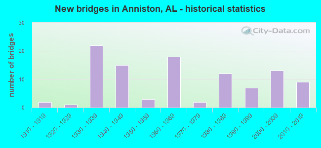
- New bridges - historical statistics
- 21910-1919
- 11920-1929
- 221930-1939
- 151940-1949
- 31950-1959
- 181960-1969
- 21970-1979
- 121980-1989
- 71990-1999
- 132000-2009
- 92010-2019
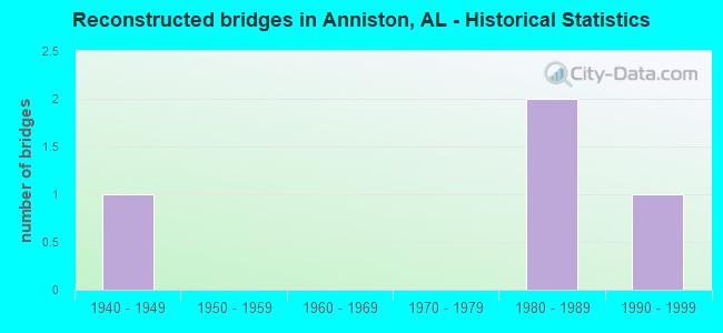
- Reconstructed bridges - Historical Statistics
- 11940-1949
- 01950-1959
- 01960-1969
- 01970-1979
- 21980-1989
- 11990-1999
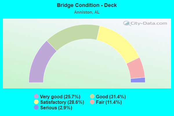
- Bridge Condition - Deck
- 25.7%Very good
- 31.4%Good
- 28.6%Satisfactory
- 11.4%Fair
- 2.9%Serious
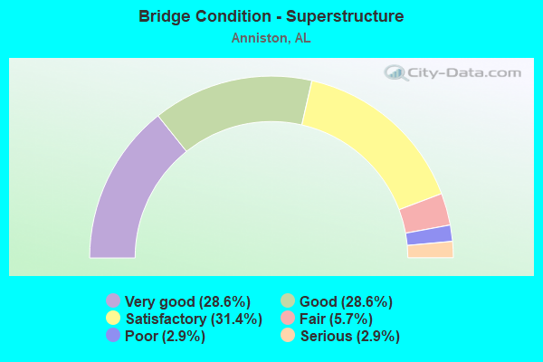
- Bridge Condition - Superstructure
- 28.6%Very good
- 28.6%Good
- 31.4%Satisfactory
- 5.7%Fair
- 2.9%Poor
- 2.9%Serious
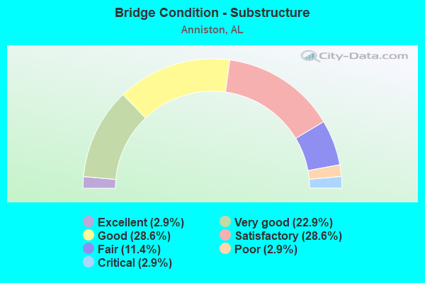
- Bridge Condition - Substructure
- 2.9%Excellent
- 22.9%Very good
- 28.6%Good
- 28.6%Satisfactory
- 11.4%Fair
- 2.9%Poor
- 2.9%Critical
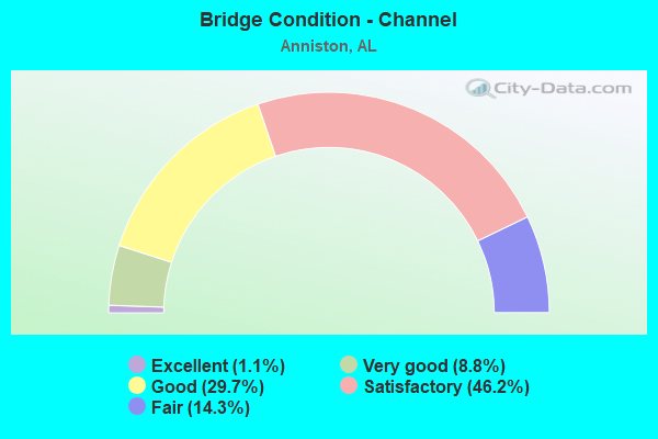
- Bridge Condition - Channel
- 1.1%Excellent
- 8.8%Very good
- 29.7%Good
- 46.2%Satisfactory
- 14.3%Fair
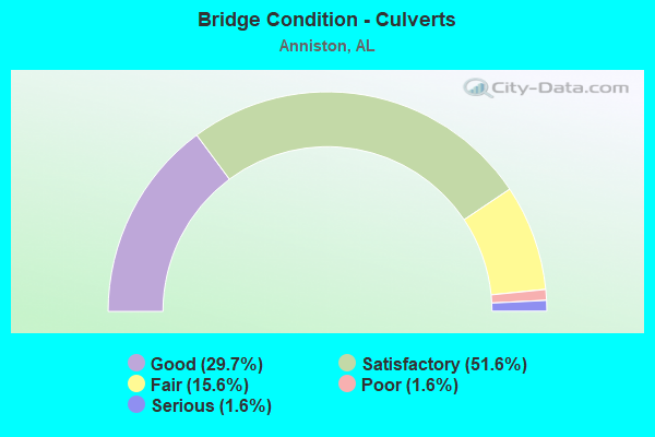
- Bridge Condition - Culverts
- 29.7%Good
- 51.6%Satisfactory
- 15.6%Fair
- 1.6%Poor
- 1.6%Serious
Find on map >> Show street view
Structure Number: 18608, Location: 6A1 (Lat: 33.727733, Lng: -85.978733), Route carried "on" structure: State lands road , Year Built: 1999, Status: Closed, Structure Length: 0.72m (2.36ft), Average Daily Traffic: 150 (year 2018), Truck Traffic: 25%, Average Future Daily Traffic: 200 (year 2038), Design Load: H 15, Features Intersected: CANE CREEK, Facility Carried by Structure: PELHAM RANGE 6A1
Minimum Vertical Clearance: 30+ m (98+ ft), Kilometerpoint: 0.000, Lanes on structure: 1, Owner: State Highway Agency, Maintenance Responsibility: State Agenciy, Approaching Roadway Width: 6.1m (20.0ft), Material/Design: Steel, Design/Construction: Culvert, Number Of Spans In Main Unit: 6, Length of Maximum Span: 0.9m (3.0ft), Curb-To-Curb Width: 5.5m (18.0ft), Out-to-Out Width: 5.5m (18.0ft)
Condition: Channel: Fair, Culverts: Fair, Deck Geometry: High priority of corrective action, Waterway Adequacy: Meets minimum limits, Approach Roadway Alignment: High priority of corrective action, Bridge Posting: Required (Relationship of Operating Rating to Maximum Legal Load: > 39.9% below), Length Of Structure Improvement: 1.35m (4.43ft), Designated Inspection Frequency: Every 24 months, Inspection Date: April 2018, Bridge Improvement Cost: $313,000, Roadway Improvement Cost: $31,000, Total Project Cost: $344,000 ( Estimate for 2022), Deck Structure Type: Concrete Cast-file-Place
Find on map >> Show street view
Structure Number: 18609, Location: RANGE 8B1 (Lat: 33.688611, Lng: -86.006111), Route carried "on" structure: State lands road , Year Built: 1960, Status: Open, Structure Length: 0.91m (2.99ft), Average Daily Traffic: 50 (year 2021), Average Future Daily Traffic: 150 (year 2041), Design Load: H 15, Features Intersected: TRIBUTARY OFF CANE CREEK, Facility Carried by Structure: PELHAM RANGE 8B1
Minimum Vertical Clearance: 30+ m (98+ ft), Kilometerpoint: 0.000, Lanes on structure: 2, Toll: Toll bridge is a segment, Owner: State Agenciy, Approaching Roadway Width: 5.5m (18.0ft), Material/Design: Steel, Design/Construction: Culvert, Number Of Spans In Main Unit: 2, Length of Maximum Span: 4.1m (13.5ft), Curb-To-Curb Width: 5.4m (17.7ft), Out-to-Out Width: 5.7m (18.7ft)
Condition: Channel: Good, Culverts: Good, Operating Rating: 40.5 metric tons, Method Used To Determine Operating Rating: Load and Resistance Factor (LRFR), Inventory Rating: 29.6 metric tons, Method Used To Determine Inventory Rating: Load and Resistance Factor (LRFR), Structural Evaluation: Better than present minimum criteria, Waterway Adequacy: Meets minimum limits, Approach Roadway Alignment: Equal to present minimum criteria, Length Of Structure Improvement: 1.59m (5.22ft), Designated Inspection Frequency: Every 24 months, Inspection Date: April 2021, Bridge Improvement Cost: $238,000, Roadway Improvement Cost: $24,000, Total Project Cost: $262,000 ( Estimate for 2022)
Find on map >> Show street view
Structure Number: 18611, Location: TRAINING AREA 1D2 (Lat: 33.732039, Lng: -85.885403), Route carried "on" structure: State lands road , Year Built: 1960, Year Reconstructed: 2001, Status: Closed, Structure Length: 0.66m (2.17ft), Average Daily Traffic: 150 (year 2019), Truck Traffic: 25%, Average Future Daily Traffic: 200 (year 2039), Features Intersected: BRANCH, Facility Carried by Structure: DIRT ROAD
Minimum Vertical Clearance: 30+ m (98+ ft), Kilometerpoint: 0.000, Lanes on structure: 1, Toll: Toll bridge is a segment, Owner: State Highway Agency, Maintenance Responsibility: State Agenciy, Approaching Roadway Width: 3.7m (12.1ft), Material/Design: Wood or Timber, Design/Construction: Stringer/Multi-beam, Number Of Spans In Main Unit: 1, Length of Maximum Span: 6.4m (21.0ft), Curb-To-Curb Width: 3.4m (11.2ft), Out-to-Out Width: 3.7m (12.1ft)
Condition: Deck: Very good, Superstructure: Very good, Substructure: Fair, Channel: Good, Waterway Adequacy: High priority of corrective action, Approach Roadway Alignment: Equal to present minimum criteria, Bridge Posting: Required (Relationship of Operating Rating to Maximum Legal Load: > 39.9% below), Length Of Structure Improvement: 1.29m (4.23ft), Designated Inspection Frequency: Every 24 months, Other Special Inspection Frequency: Every 12 months, Inspection Date: April 2019, Other Special Inspection Date: April 2019, Bridge Improvement Cost: $106,000, Roadway Improvement Cost: $11,000, Total Project Cost: $117,000 ( Estimate for 2022), Deck Structure Type: Wood or Timber, Wearing Surface/Protective System: Wearing Surface: Wood or Timber
Find on map >> Show street view
Structure Number: 18612, Location: TRAINING RANGE 23A1 (Lat: 33.712975, Lng: -85.750056), Route carried "on" structure: State lands road , Year Built: 1960, Status: Open, Structure Length: 1.07m (3.51ft), Average Daily Traffic: 50 (year 2021), Average Future Daily Traffic: 150 (year 2041), Features Intersected: TRIBUTARY TO CANE CREEK, Facility Carried by Structure: DIRT ROAD
Minimum Vertical Clearance: 30+ m (98+ ft), Kilometerpoint: 0.000, Lanes on structure: 1, Toll: Toll bridge is a segment, Owner: State Agenciy, Approaching Roadway Width: 5.5m (18.0ft), Material/Design: Steel continuous, Design/Construction: Stringer/Multi-beam, Number Of Spans In Main Unit: 3, Length of Maximum Span: 3.4m (11.2ft), Curb-To-Curb Width: 4.3m (14.1ft), Out-to-Out Width: 4.9m (16.1ft)
Condition: Deck: Very good, Superstructure: Satisfactory, Substructure: Fair, Channel: Fair, Operating Rating: 33.7 metric tons, Method Used To Determine Operating Rating: Load Factor (LF), Inventory Rating: 25.3 metric tons, Method Used To Determine Inventory Rating: Load Factor (LF), Structural Evaluation: Somewhat better than minimum adequacy, Deck Geometry: Equal to present minimum criteria, Waterway Adequacy: Better than present minimum criteria, Approach Roadway Alignment: Equal to present desirable criteria, Length Of Structure Improvement: 1.74m (5.71ft), Designated Inspection Frequency: Every 24 months, Inspection Date: April 2021, Bridge Improvement Cost: $191,000, Roadway Improvement Cost: $19,000, Total Project Cost: $210,000 ( Estimate for 2022), Deck Structure Type: Wood or Timber, Wearing Surface/Protective System: Wearing Surface: Wood or Timber
Find on map >> Show street view
Structure Number: 18614, Location: TRAINING AREA 24B1 (Lat: 33.727947, Lng: -85.986069), Route carried "on" structure: State lands road , Year Built: 1960, Status: Closed, Structure Length: 3.66m (12.01ft), Average Daily Traffic: 150 (year 2002), Truck Traffic: 25%, Average Future Daily Traffic: 200 (year 2022), Features Intersected: CANE CREEK, Facility Carried by Structure: DIRT ROAD
Minimum Vertical Clearance: 30+ m (98+ ft), Kilometerpoint: 0.000, Lanes on structure: 1, Toll: Toll bridge is a segment, Owner: State Highway Agency, Maintenance Responsibility: State Agenciy, Approaching Roadway Width: 5.8m (19.0ft), Material/Design: Wood or Timber, Design/Construction: Stringer/Multi-beam, Number Of Spans In Main Unit: 8, Length of Maximum Span: 4.6m (15.1ft), Curb-To-Curb Width: 3.9m (12.8ft), Out-to-Out Width: 4.2m (13.8ft)
Condition: Deck: Fair, Superstructure: Satisfactory, Substructure: Critical, Channel: Good, Waterway Adequacy: Equal to present minimum criteria, Approach Roadway Alignment: Equal to present minimum criteria, Bridge Posting: Required (Relationship of Operating Rating to Maximum Legal Load: > 39.9% below), Length Of Structure Improvement: 4.58m (15.03ft), Designated Inspection Frequency: Every 24 months, Inspection Date: October 2001, Bridge Improvement Cost: $408,000, Roadway Improvement Cost: $41,000, Total Project Cost: $449,000 ( Estimate for 2022), Deck Structure Type: Steel plate, Wearing Surface/Protective System: Wearing Surface: Gravel
Find on map >> Show street view
Structure Number: 18615, Location: FORT MCCLELLAN (Lat: 33.733700, Lng: -85.789700), Route carried "on" structure: State lands road , Year Built: 1936, Status: Open, Structure Length: 1.08m (3.54ft), Average Daily Traffic: 150 (year 2020), Average Future Daily Traffic: 200 (year 2040), Design Load: H 15, Features Intersected: TRIBUTARY TO CANE CREEK, Facility Carried by Structure: PATRIOT ROAD
Minimum Vertical Clearance: 30+ m (98+ ft), Kilometerpoint: 0.000, Lanes on structure: 2, Owner: State Highway Agency, Maintenance Responsibility: State Agenciy, Approaching Roadway Width: 8.5m (27.9ft), Material/Design: Steel, Design/Construction: Culvert, Number Of Spans In Main Unit: 2, Length of Maximum Span: 5.1m (16.7ft), Curb or Sidewalk Widths: Left: 2.1m (6.9ft), Right: 2.1m (6.9ft), Curb-To-Curb Width: 11.0m (36.1ft), Out-to-Out Width: 11.7m (38.4ft)
Condition: Channel: Satisfactory, Culverts: Satisfactory, Operating Rating: 88.9 metric tons, Method Used To Determine Operating Rating: Load and Resistance Factor (LRFR), Inventory Rating: 88.9 metric tons, Method Used To Determine Inventory Rating: Load and Resistance Factor (LRFR), Structural Evaluation: Equal to present minimum criteria, Deck Geometry: Equal to present desirable criteria, Waterway Adequacy: Equal to present minimum criteria, Approach Roadway Alignment: Equal to present desirable criteria, Length Of Structure Improvement: 1.75m (5.74ft), Designated Inspection Frequency: Every 24 months, Inspection Date: April 2020, Bridge Improvement Cost: $354,000, Roadway Improvement Cost: $35,000, Total Project Cost: $389,000 ( Estimate for 2022)
Find on map >> Show street view
Structure Number: 18785, Location: MEDDERS DR (Lat: 33.720989, Lng: -85.832083), Route carried "on" structure: County highway , Year Built: 2002, Status: Open, Structure Length: 2.26m (7.41ft), Average Daily Traffic: 196 (year 2019), Truck Traffic: 2%, Average Future Daily Traffic: 297 (year 2040), Design Load: HS 20, Features Intersected: UNKNOWN TRIBUTARY, Facility Carried by Structure: MEDDERS DRIVE
Minimum Vertical Clearance: 30+ m (98+ ft), Kilometerpoint: 0.000, Lanes on structure: 2, Owner: County Highway Agency, Approaching Roadway Width: 6.7m (22.0ft), Skew: 4 degrees, Material/Design: Concrete, Design/Construction: Culvert, Number Of Spans In Main Unit: 3, Length of Maximum Span: 4.3m (14.1ft), Curb or Sidewalk Widths: Left: 0.3m (1.0ft), Right: 0.3m (1.0ft), Curb-To-Curb Width: 9.1m (29.9ft), Out-to-Out Width: 9.8m (32.2ft)
Condition: Channel: Good, Culverts: Satisfactory, Operating Rating: 39.6 metric tons, Method Used To Determine Operating Rating: Load Factor (LF), Inventory Rating: 23.8 metric tons, Method Used To Determine Inventory Rating: Load Factor (LF), Structural Evaluation: Equal to present minimum criteria, Deck Geometry: Equal to present minimum criteria, Waterway Adequacy: Equal to present desirable criteria, Approach Roadway Alignment: Equal to present desirable criteria, Length Of Structure Improvement: 3.07m (10.07ft), Designated Inspection Frequency: Every 24 months, Inspection Date: November 2020, Bridge Improvement Cost: $799,000, Roadway Improvement Cost: $80,000, Total Project Cost: $879,000 ( Estimate for 2022)
Find on map >> Show street view
Structure Number: 19326, Location: .2 MI W OF SR21 (Lat: 33.697631, Lng: -85.825358), Route carried "on" structure: Bypass City street , Year Built: 2009, Status: Open, Structure Length: 0.67m (2.20ft), Average Daily Traffic: 100 (year 2019), Average Future Daily Traffic: 120 (year 2039), Design Load: HS 20, Features Intersected: STREAM, Facility Carried by Structure: PELHAM ROAD
Minimum Vertical Clearance: 30+ m (98+ ft), Kilometerpoint: 21.855, Lanes on structure: 3, Owner: State Highway Agency, Approaching Roadway Width: 17.2m (56.4ft), Material/Design: Concrete, Design/Construction: Culvert, Number Of Spans In Main Unit: 2, Length of Maximum Span: 3.0m (9.8ft)
Condition: Channel: Good, Culverts: Good, Operating Rating: 87.5 metric tons, Method Used To Determine Operating Rating: Load Factor (LF), Inventory Rating: 52.5 metric tons, Method Used To Determine Inventory Rating: Load Factor (LF), Structural Evaluation: Better than present minimum criteria, Waterway Adequacy: Equal to present desirable criteria, Approach Roadway Alignment: Equal to present desirable criteria, Length Of Structure Improvement: 1.31m (4.30ft), Designated Inspection Frequency: Every 24 months, Inspection Date: January 2021, Bridge Improvement Cost: $709,000, Roadway Improvement Cost: $71,000, Total Project Cost: $780,000 ( Estimate for 2022)
Find on map >> Show street view
Structure Number: 19328, Location: INTERSECT OF SR1/SR21 (Lat: 33.702022, Lng: -85.822833), Route carried "on" structure: US 431, Year Built: 2011, Status: Open, Structure Length: 16.12m (52.89ft), Average Daily Traffic: 4,600 (year 2020), Truck Traffic: 9%, Average Future Daily Traffic: 6,440 (year 2040), Design Load: HS 20, Features Intersected: SR21
Minimum Vertical Clearance: 30+ m (98+ ft), Kilometerpoint: 414.647, Lanes on structure: 3, Lanes under structure: 7, Base Highway Network: Yes, Owner: State Highway Agency, Approaching Roadway Width: 7.3m (24.0ft), Skew: 11 degrees, Material/Design: Prestressed concrete, Design/Construction: Stringer/Multi-beam, Number Of Spans In Main Unit: 4, Length of Maximum Span: 39.6m (129.9ft), Curb-To-Curb Width: 15.8m (51.8ft), Out-to-Out Width: 16.7m (54.8ft)
Condition: Deck: Very good, Superstructure: Very good, Substructure: Very good, Operating Rating: 83.2 metric tons, Method Used To Determine Operating Rating: Load Factor (LF), Inventory Rating: 45.0 metric tons, Method Used To Determine Inventory Rating: Load Factor (LF), Structural Evaluation: Equal to present desirable criteria, Deck Geometry: Better than present minimum criteria, Underclear: Equal to present minimum criteria, Approach Roadway Alignment: Equal to present desirable criteria, Length Of Structure Improvement: 16.87m (55.35ft), Designated Inspection Frequency: Every 24 months, Inspection Date: September 2021, Bridge Improvement Cost: $6,247,000, Roadway Improvement Cost: $625,000, Total Project Cost: $6,872,000 ( Estimate for 2022), Deck Structure Type: Concrete Cast-file-Place
Find on map >> Show street view
Structure Number: 19356, Location: INTERSECTION OF SR1/SR21 (Lat: 33.700917, Lng: -85.822917), Route carried "on" structure: US 431, Year Built: 2011, Status: Open, Structure Length: 16.12m (52.89ft), Average Daily Traffic: 4,600 (year 2020), Truck Traffic: 9%, Average Future Daily Traffic: 6,440 (year 2040), Design Load: HS 20, Features Intersected: SR21
Minimum Vertical Clearance: 30+ m (98+ ft), Kilometerpoint: 414.615, Lanes on structure: 3, Lanes under structure: 7, Base Highway Network: Yes, Owner: State Highway Agency, Approaching Roadway Width: 15.7m (51.5ft), Skew: 11 degrees, Material/Design: Prestressed concrete, Design/Construction: Stringer/Multi-beam, Number Of Spans In Main Unit: 5, Length of Maximum Span: 39.6m (129.9ft), Curb-To-Curb Width: 10.6m (34.8ft), Out-to-Out Width: 16.7m (54.8ft)
Condition: Deck: Very good, Superstructure: Very good, Substructure: Very good, Operating Rating: 83.2 metric tons, Method Used To Determine Operating Rating: Load Factor (LF), Inventory Rating: 45.0 metric tons, Method Used To Determine Inventory Rating: Load Factor (LF), Structural Evaluation: Equal to present desirable criteria, Deck Geometry: High priority of replacement, Underclear: Superior to present desirable criteria, Approach Roadway Alignment: Equal to present desirable criteria, Length Of Structure Improvement: 16.87m (55.35ft), Designated Inspection Frequency: Every 24 months, Inspection Date: September 2021, Bridge Improvement Cost: $6,247,000, Roadway Improvement Cost: $625,000, Total Project Cost: $6,872,000 ( Estimate for 2022), Deck Structure Type: Concrete Cast-file-Place
Find on map >> Show street view
Structure Number: 19518, Location: .8 MI. NORTH OF SR4/US78 (Lat: 33.627111, Lng: -85.786139), Route carried "on" structure: Bypass US 431, Year Built: 2003, Status: Open, Structure Length: 1.03m (3.38ft), Average Daily Traffic: 19,991 (year 2019), Truck Traffic: 5%, Average Future Daily Traffic: 27,987 (year 2039), Design Load: HS 20, Features Intersected: BRANCH
Minimum Vertical Clearance: 30+ m (98+ ft), Kilometerpoint: 363.905, Lanes on structure: 5, Base Highway Network: Yes, Owner: State Highway Agency, Approaching Roadway Width: 19.0m (62.3ft), Skew: 4 degrees, Material/Design: Concrete, Design/Construction: Culvert, Number Of Spans In Main Unit: 3, Length of Maximum Span: 2.4m (7.9ft)
Condition: Channel: Very good, Culverts: Good, Operating Rating: 88.9 metric tons, Method Used To Determine Operating Rating: Load Factor (LF), Inventory Rating: 55.9 metric tons, Method Used To Determine Inventory Rating: Load Factor (LF), Structural Evaluation: Better than present minimum criteria, Waterway Adequacy: Equal to present desirable criteria, Approach Roadway Alignment: Equal to present desirable criteria, Length Of Structure Improvement: 1.71m (5.61ft), Designated Inspection Frequency: Every 24 months, Inspection Date: Febuary 2021, Bridge Improvement Cost: $1,401,000, Roadway Improvement Cost: $140,000, Total Project Cost: $1,541,000 ( Estimate for 2022)
Find on map >> Show street view
Structure Number: 19685, Location: .92 MI N OF I20 (Lat: 33.595944, Lng: -85.925139), Route carried "on" structure: Bypass State highway 202, Year Built: 2001, Status: Open, Structure Length: 0.78m (2.56ft), Average Daily Traffic: 11,706 (year 2020), Truck Traffic: 4%, Average Future Daily Traffic: 16,388 (year 2040), Design Load: HS 20, Features Intersected: CREEK
Minimum Vertical Clearance: 30+ m (98+ ft), Kilometerpoint: 1.481, Lanes on structure: 6, Owner: State Highway Agency, Approaching Roadway Width: 28.0m (91.9ft), Skew: 1 degrees, Material/Design: Concrete, Design/Construction: Culvert, Number Of Spans In Main Unit: 3, Length of Maximum Span: 2.5m (8.2ft)
Condition: Channel: Good, Culverts: Good, Operating Rating: 88.9 metric tons, Method Used To Determine Operating Rating: Load Factor (LF), Inventory Rating: 88.9 metric tons, Method Used To Determine Inventory Rating: Load Factor (LF), Structural Evaluation: Better than present minimum criteria, Waterway Adequacy: Equal to present minimum criteria, Approach Roadway Alignment: Equal to present desirable criteria, Length Of Structure Improvement: 1.44m (4.72ft), Designated Inspection Frequency: Every 24 months, Inspection Date: October 2021, Bridge Improvement Cost: $1,496,000, Roadway Improvement Cost: $150,000, Total Project Cost: $1,646,000 ( Estimate for 2022)
Find on map >> Show street view
Structure Number: 19686, Location: 1.25 MI N OF I20 (Lat: 33.600889, Lng: -85.926444), Route carried "on" structure: Bypass State highway 202, Year Built: 2001, Status: Open, Structure Length: 1.56m (5.12ft), Average Daily Traffic: 13,375 (year 2020), Truck Traffic: 6%, Average Future Daily Traffic: 18,725 (year 2040), Design Load: HS 20, Features Intersected: COLDWATER SPRING BRANCH
Minimum Vertical Clearance: 30+ m (98+ ft), Kilometerpoint: 2.012, Lanes on structure: 5, Owner: State Highway Agency, Approaching Roadway Width: 24.4m (80.1ft), Skew: 6 degrees, Material/Design: Concrete, Design/Construction: Culvert, Number Of Spans In Main Unit: 3, Length of Maximum Span: 4.9m (16.1ft)
Condition: Channel: Very good, Culverts: Good, Operating Rating: 88.9 metric tons, Method Used To Determine Operating Rating: Load Factor (LF), Inventory Rating: 54.1 metric tons, Method Used To Determine Inventory Rating: Load Factor (LF), Structural Evaluation: Better than present minimum criteria, Waterway Adequacy: Equal to present desirable criteria, Approach Roadway Alignment: Equal to present desirable criteria, Length Of Structure Improvement: 2.24m (7.35ft), Designated Inspection Frequency: Every 24 months, Inspection Date: October 2021, Bridge Improvement Cost: $3,161,000, Roadway Improvement Cost: $316,000, Total Project Cost: $3,477,000 ( Estimate for 2022)
Find on map >> Show street view
Structure Number: 19687, Location: 2.8 MI N OF I20 (Lat: 33.620681, Lng: -85.923311), Route carried "on" structure: Bypass State highway 202, Year Built: 2001, Status: Open, Structure Length: 1.84m (6.04ft), Average Daily Traffic: 12,810 (year 2020), Truck Traffic: 4%, Average Future Daily Traffic: 17,934 (year 2040), Design Load: HS 20, Features Intersected: CASTLEBERRY BRANCH
Minimum Vertical Clearance: 30+ m (98+ ft), Kilometerpoint: 4.506, Lanes on structure: 5, Owner: State Highway Agency, Approaching Roadway Width: 25.3m (83.0ft), Skew: 6 degrees, Material/Design: Concrete, Design/Construction: Culvert, Number Of Spans In Main Unit: 3, Length of Maximum Span: 5.8m (19.0ft)
Condition: Channel: Very good, Culverts: Good, Operating Rating: 88.9 metric tons, Method Used To Determine Operating Rating: Load Factor (LF), Inventory Rating: 72.4 metric tons, Method Used To Determine Inventory Rating: Load Factor (LF), Structural Evaluation: Better than present minimum criteria, Waterway Adequacy: Equal to present desirable criteria, Approach Roadway Alignment: Equal to present desirable criteria, Length Of Structure Improvement: 2.55m (8.37ft), Designated Inspection Frequency: Every 24 months, Inspection Date: October 2021, Bridge Improvement Cost: $4,116,000, Roadway Improvement Cost: $412,000, Total Project Cost: $4,528,000 ( Estimate for 2022)
Find on map >> Show street view
Structure Number: 19873, Location: JIMMY PARKS BLVD (Lat: 33.718750, Lng: -85.790111), Route carried "on" structure: City street , Year Built: 1936, Status: Open, Structure Length: 1.01m (3.31ft), Average Daily Traffic: 4,800 (year 2021), Truck Traffic: 1%, Average Future Daily Traffic: 6,000 (year 2041), Design Load: H 15, Features Intersected: CANE CREEK, Facility Carried by Structure: JIMMY PARKS BLVD
Minimum Vertical Clearance: 30+ m (98+ ft), Kilometerpoint: 2.028, Lanes on structure: 2, Owner: City or Municipal Highway Agency, Approaching Roadway Width: 6.1m (20.0ft), Material/Design: Concrete, Design/Construction: Tee Beam, Number Of Spans In Main Unit: 1, Length of Maximum Span: 10.1m (33.1ft), Curb or Sidewalk Widths: Left: 0.2m (0.7ft), Right: 0.2m (0.7ft), Curb-To-Curb Width: 7.6m (24.9ft), Out-to-Out Width: 8.4m (27.6ft)
Condition: Deck: Satisfactory, Superstructure: Satisfactory, Substructure: Satisfactory, Channel: Satisfactory, Operating Rating: 45.9 metric tons, Method Used To Determine Operating Rating: Load Factor (LF), Inventory Rating: 27.6 metric tons, Method Used To Determine Inventory Rating: Load Factor (LF), Structural Evaluation: Equal to present minimum criteria, Deck Geometry: High priority of replacement, Waterway Adequacy: Better than present minimum criteria, Approach Roadway Alignment: Better than present minimum criteria, Length Of Structure Improvement: 1.68m (5.51ft), Designated Inspection Frequency: Every 24 months, Inspection Date: Febuary 2021, Bridge Improvement Cost: $310,000, Roadway Improvement Cost: $31,000, Total Project Cost: $341,000 ( Estimate for 2022), Deck Structure Type: Concrete Cast-file-Place
Find on map >> Show street view
Structure Number: 19874, Location: Galloway Road (Lat: 33.724056, Lng: -85.800917), Route carried "on" structure: City street , Year Built: 1936, Status: Open, Structure Length: 0.83m (2.72ft), Average Daily Traffic: 4,800 (year 2021), Truck Traffic: 1%, Average Future Daily Traffic: 6,000 (year 2041), Design Load: H 15, Features Intersected: TRIBUTARY TO CANE CREEK, Facility Carried by Structure: GALLOWAY ROAD
Minimum Vertical Clearance: 30+ m (98+ ft), Kilometerpoint: 0.966, Lanes on structure: 2, Owner: City or Municipal Highway Agency, Approaching Roadway Width: 6.1m (20.0ft), Material/Design: Steel, Design/Construction: Culvert, Number Of Spans In Main Unit: 2, Number Of Approach Spans: 2, Length of Maximum Span: 1.8m (5.9ft), Out-to-Out Width: 16.9m (55.4ft)
Condition: Channel: Satisfactory, Culverts: Satisfactory, Operating Rating: 88.9 metric tons, Method Used To Determine Operating Rating: Load Factor (LF), Inventory Rating: 84.7 metric tons, Method Used To Determine Inventory Rating: Load Factor (LF), Structural Evaluation: Equal to present minimum criteria, Waterway Adequacy: Equal to present minimum criteria, Approach Roadway Alignment: Equal to present minimum criteria, Length Of Structure Improvement: 1.49m (4.89ft), Designated Inspection Frequency: Every 24 months, Inspection Date: Febuary 2021, Bridge Improvement Cost: $474,000, Roadway Improvement Cost: $47,000, Total Project Cost: $521,000 ( Estimate for 2022), Deck Structure Type: Corrugated Steel
Find on map >> Show street view
Structure Number: 19875, Location: FEDERAL WAY (Lat: 33.720750, Lng: -85.793611), Route carried "on" structure: City street , Year Built: 1936, Status: Open, Structure Length: 1.13m (3.71ft), Average Daily Traffic: 4,800 (year 2021), Truck Traffic: 1%, Average Future Daily Traffic: 6,000 (year 2041), Design Load: H 15, Features Intersected: CANE CREEK, Facility Carried by Structure: FEDERAL WAY
Minimum Vertical Clearance: 30+ m (98+ ft), Kilometerpoint: 2.414, Lanes on structure: 2, Owner: City or Municipal Highway Agency, Approaching Roadway Width: 6.3m (20.7ft), Material/Design: Steel, Design/Construction: Culvert, Number Of Spans In Main Unit: 2, Length of Maximum Span: 4.8m (15.7ft), Curb-To-Curb Width: 12.3m (40.4ft), Out-to-Out Width: 13.1m (43.0ft)
Condition: Channel: Satisfactory, Culverts: Satisfactory, Operating Rating: 88.9 metric tons, Method Used To Determine Operating Rating: Load and Resistance Factor (LRFR), Inventory Rating: 88.9 metric tons, Method Used To Determine Inventory Rating: Load and Resistance Factor (LRFR), Structural Evaluation: Equal to present minimum criteria, Deck Geometry: Equal to present minimum criteria, Waterway Adequacy: Equal to present minimum criteria, Approach Roadway Alignment: Equal to present minimum criteria, Length Of Structure Improvement: 1.80m (5.91ft), Designated Inspection Frequency: Every 24 months, Inspection Date: Febuary 2021, Bridge Improvement Cost: $437,000, Roadway Improvement Cost: $44,000, Total Project Cost: $481,000 ( Estimate for 2022), Deck Structure Type: Corrugated Steel
Find on map >> Show street view
Structure Number: 19876, Location: GOODE ROAD (Lat: 33.727944, Lng: -85.787500), Route carried "on" structure: City street , Year Built: 1936, Status: Open, Structure Length: 1.06m (3.48ft), Average Daily Traffic: 4,800 (year 2021), Truck Traffic: 1%, Average Future Daily Traffic: 6,000 (year 2041), Design Load: H 15, Features Intersected: CREEK, Facility Carried by Structure: GOODE ROAD
Minimum Vertical Clearance: 30+ m (98+ ft), Kilometerpoint: 3.621, Lanes on structure: 2, Owner: City or Municipal Highway Agency, Approaching Roadway Width: 6.9m (22.6ft), Material/Design: Steel, Design/Construction: Culvert, Number Of Spans In Main Unit: 2, Length of Maximum Span: 10.6m (34.8ft), Curb-To-Curb Width: 12.4m (40.7ft), Out-to-Out Width: 13.1m (43.0ft)
Condition: Channel: Satisfactory, Culverts: Satisfactory, Operating Rating: 36.1 metric tons, Method Used To Determine Operating Rating: Load Factor (LF), Inventory Rating: 29.1 metric tons, Method Used To Determine Inventory Rating: Load Factor (LF), Structural Evaluation: Equal to present minimum criteria, Deck Geometry: Equal to present minimum criteria, Waterway Adequacy: Equal to present minimum criteria, Approach Roadway Alignment: Equal to present minimum criteria, Length Of Structure Improvement: 1.74m (5.71ft), Designated Inspection Frequency: Every 24 months, Inspection Date: Febuary 2021, Bridge Improvement Cost: $422,000, Roadway Improvement Cost: $42,000, Total Project Cost: $464,000 ( Estimate for 2022), Deck Structure Type: Corrugated Steel
Find on map >> Show street view
Structure Number: 19958, Location: 0.8 MI N. US 78 (Lat: 33.625617, Lng: -85.787250), Route carried "on" structure: City street , Year Built: 1997, Status: Open, Structure Length: 1.07m (3.51ft), Average Daily Traffic: 1,000 (year 2021), Truck Traffic: 20%, Average Future Daily Traffic: 2,000 (year 2041), Design Load: H 15, Features Intersected: BRANCH, Facility Carried by Structure: RED MORRIS PKWY.
Minimum Vertical Clearance: 30+ m (98+ ft), Kilometerpoint: 1.287, Lanes on structure: 2, Owner: City or Municipal Highway Agency, Approaching Roadway Width: 9.8m (32.2ft), Skew: 1 degrees, Material/Design: Concrete, Design/Construction: Culvert, Number Of Spans In Main Unit: 4, Length of Maximum Span: 2.6m (8.5ft), Curb-To-Curb Width: 9.8m (32.2ft), Out-to-Out Width: 16.5m (54.1ft)
Condition: Channel: Good, Culverts: Good, Operating Rating: 43.0 metric tons, Method Used To Determine Operating Rating: Load Factor (LF), Inventory Rating: 25.8 metric tons, Method Used To Determine Inventory Rating: Load Factor (LF), Structural Evaluation: Equal to present minimum criteria, Deck Geometry: Equal to present minimum criteria, Waterway Adequacy: Equal to present desirable criteria, Approach Roadway Alignment: Equal to present desirable criteria, Length Of Structure Improvement: 1.75m (5.74ft), Designated Inspection Frequency: Every 24 months, Inspection Date: Febuary 2021, Bridge Improvement Cost: $576,000, Roadway Improvement Cost: $58,000, Total Project Cost: $634,000 ( Estimate for 2022)
Find on map >> Show street view
Structure Number: 19959, Location: 1.3 MI NE US HWY 78 (Lat: 33.630500, Lng: -85.799000), Route carried "on" structure: City street , Year Built: 1997, Status: Open, Structure Length: 0.63m (2.07ft), Average Daily Traffic: 1,000 (year 2021), Average Future Daily Traffic: 1,400 (year 2041), Design Load: H 15, Features Intersected: BRANCH, Facility Carried by Structure: LYDA RD.
Minimum Vertical Clearance: 30+ m (98+ ft), Kilometerpoint: 2.092, Lanes on structure: 2, Owner: City or Municipal Highway Agency, Approaching Roadway Width: 7.4m (24.3ft), Material/Design: Concrete, Design/Construction: Culvert, Number Of Spans In Main Unit: 2, Length of Maximum Span: 3.0m (9.8ft), Curb-To-Curb Width: 11.7m (38.4ft), Out-to-Out Width: 12.0m (39.4ft)
Condition: Channel: Satisfactory, Culverts: Satisfactory, Operating Rating: 52.4 metric tons, Method Used To Determine Operating Rating: Load Factor (LF), Inventory Rating: 31.5 metric tons, Method Used To Determine Inventory Rating: Load Factor (LF), Structural Evaluation: Equal to present minimum criteria, Deck Geometry: Better than present minimum criteria, Waterway Adequacy: Equal to present desirable criteria, Approach Roadway Alignment: Equal to present desirable criteria, Length Of Structure Improvement: 1.25m (4.10ft), Designated Inspection Frequency: Every 24 months, Inspection Date: Febuary 2021, Bridge Improvement Cost: $281,000, Roadway Improvement Cost: $28,000, Total Project Cost: $309,000 ( Estimate for 2022)
Find on map >> Show street view
Structure Number: 20125, Location: PELHAM RANGE ALA (Lat: 33.729167, Lng: -85.911111), Route carried "on" structure: ServiceState lands road , Year Built: 2007, Status: Open, Structure Length: 3.66m (12.01ft), Average Daily Traffic: 150 (year 2021), Average Future Daily Traffic: 500 (year 2041), Design Load: HS 20, Features Intersected: CANE CREEK, Facility Carried by Structure: GATE 3 ROAD
Minimum Vertical Clearance: 30+ m (98+ ft), Kilometerpoint: 0.000, Lanes on structure: 2, Owner: State Agenciy, Approaching Roadway Width: 7.3m (24.0ft), Material/Design: Prestressed concrete, Design/Construction: Stringer/Multi-beam, Number Of Spans In Main Unit: 3, Length of Maximum Span: 12.2m (40.0ft), Curb or Sidewalk Widths: Left: 0.3m (1.0ft), Right: 0.3m (1.0ft), Curb-To-Curb Width: 7.3m (24.0ft), Out-to-Out Width: 9.1m (29.9ft)
Condition: Deck: Very good, Superstructure: Very good, Substructure: Excellent, Channel: Excellent, Operating Rating: 83.9 metric tons, Method Used To Determine Operating Rating: Load Factor (LF), Inventory Rating: 50.3 metric tons, Method Used To Determine Inventory Rating: Load Factor (LF), Structural Evaluation: Equal to present desirable criteria, Deck Geometry: Somewhat better than minimum adequacy, Waterway Adequacy: Equal to present desirable criteria, Approach Roadway Alignment: Somewhat better than minimum adequacy, Length Of Structure Improvement: 4.58m (15.03ft), Designated Inspection Frequency: Every 24 months, Inspection Date: April 2021, Bridge Improvement Cost: $942,000, Roadway Improvement Cost: $94,000, Total Project Cost: $1,036,000 ( Estimate for 2022), Deck Structure Type: Concrete Cast-file-Place
Find on map >> Show street view
Structure Number: 20126, Location: PELHAM RANGE (Lat: 33.720833, Lng: -86.001667), Route carried "on" structure: ServiceState lands road , Year Built: 2007, Status: Open, Structure Length: 5.49m (18.01ft), Average Daily Traffic: 250 (year 2021), Truck Traffic: 50%, Average Future Daily Traffic: 500 (year 2041), Design Load: HS 20, Features Intersected: CANE CREEK, Facility Carried by Structure: DIRT ROAD
Minimum Vertical Clearance: 30+ m (98+ ft), Kilometerpoint: 0.002, Lanes on structure: 2, Owner: State Agenciy, Approaching Roadway Width: 9.8m (32.2ft), Material/Design: Prestressed concrete, Design/Construction: Stringer/Multi-beam, Number Of Spans In Main Unit: 3, Length of Maximum Span: 18.3m (60.0ft), Curb-To-Curb Width: 9.4m (30.8ft), Out-to-Out Width: 9.8m (32.2ft)
Condition: Deck: Very good, Superstructure: Very good, Substructure: Very good, Channel: Good, Operating Rating: 86.6 metric tons, Method Used To Determine Operating Rating: Load Factor (LF), Inventory Rating: 42.8 metric tons, Method Used To Determine Inventory Rating: Load Factor (LF), Structural Evaluation: Equal to present desirable criteria, Deck Geometry: Equal to present minimum criteria, Waterway Adequacy: Equal to present desirable criteria, Approach Roadway Alignment: Equal to present desirable criteria, Length Of Structure Improvement: 6.52m (21.39ft), Designated Inspection Frequency: Every 24 months, Inspection Date: April 2021, Bridge Improvement Cost: $1,430,000, Roadway Improvement Cost: $143,000, Total Project Cost: $1,573,000 ( Estimate for 2022), Deck Structure Type: Concrete Cast-file-Place
Find on map >> Show street view
Structure Number: 2035, Location: EULATON PIKE RD. (Lat: 33.653081, Lng: -85.877219), Route carried "on" structure: County highway 38, Year Built: 2010, Status: Open, Structure Length: 0.98m (3.22ft), Average Daily Traffic: 2,672 (year 2019), Truck Traffic: 1%, Average Future Daily Traffic: 3,121 (year 2041), Design Load: HS 20, Features Intersected: BRANCH, Facility Carried by Structure: .5 MI N AL 202
Minimum Vertical Clearance: 30+ m (98+ ft), Kilometerpoint: 0.010, Lanes on structure: 2, Owner: County Highway Agency, Approaching Roadway Width: 6.1m (20.0ft), Skew: 1 degrees, Material/Design: Concrete, Design/Construction: Culvert, Number Of Spans In Main Unit: 3, Length of Maximum Span: 3.0m (9.8ft), Curb or Sidewalk Widths: Left: 0.2m (0.7ft), Right: 0.2m (0.7ft), Curb-To-Curb Width: 13.4m (44.0ft), Out-to-Out Width: 13.4m (44.0ft)
Condition: Channel: Very good, Culverts: Good, Operating Rating: 68.2 metric tons, Method Used To Determine Operating Rating: Load Factor (LF), Inventory Rating: 40.9 metric tons, Method Used To Determine Inventory Rating: Load Factor (LF), Structural Evaluation: Better than present minimum criteria, Deck Geometry: Better than present minimum criteria, Waterway Adequacy: Equal to present desirable criteria, Approach Roadway Alignment: Equal to present desirable criteria, Length Of Structure Improvement: 1.65m (5.41ft), Designated Inspection Frequency: Every 24 months, Inspection Date: June 2021, Bridge Improvement Cost: $419,000, Roadway Improvement Cost: $42,000, Total Project Cost: $461,000 ( Estimate for 2022)
Find on map >> Show street view
Structure Number: 20431, Location: 242'W BALTZELL GATE RD. (Lat: 33.720400, Lng: -85.794300), Route carried "on" structure: City street , Year Built: 1936, Status: Open, Structure Length: 1.07m (3.51ft), Average Daily Traffic: 2,000 (year 2020), Truck Traffic: 5%, Average Future Daily Traffic: 3,000 (year 2040), Design Load: H 15, Features Intersected: CANE CREEK, Facility Carried by Structure: FEDERAL WAY
Minimum Vertical Clearance: 30+ m (98+ ft), Kilometerpoint: 1.828, Lanes on structure: 2, Owner: City or Municipal Highway Agency, Approaching Roadway Width: 6.7m (22.0ft), Material/Design: Steel, Design/Construction: Culvert, Number Of Spans In Main Unit: 2, Length of Maximum Span: 4.9m (16.1ft), Curb-To-Curb Width: 10.6m (34.8ft), Out-to-Out Width: 11.4m (37.4ft)
Condition: Channel: Satisfactory, Culverts: Satisfactory, Operating Rating: 88.9 metric tons, Method Used To Determine Operating Rating: Load and Resistance Factor (LRFR), Inventory Rating: 88.9 metric tons, Method Used To Determine Inventory Rating: Load and Resistance Factor (LRFR), Structural Evaluation: Equal to present minimum criteria, Deck Geometry: Equal to present minimum criteria, Waterway Adequacy: Equal to present minimum criteria, Approach Roadway Alignment: Equal to present minimum criteria, Length Of Structure Improvement: 1.75m (5.74ft), Designated Inspection Frequency: Every 24 months, Inspection Date: August 2020, Bridge Improvement Cost: $343,000, Roadway Improvement Cost: $34,000, Total Project Cost: $377,000 ( Estimate for 2022), Deck Structure Type: Corrugated Steel
Find on map >> Show street view
Structure Number: 20432, Location: 2.5 MI NE AL HWY 21 (Lat: 33.716783, Lng: -85.784467), Route carried "on" structure: City street , Year Built: 1936, Status: Open, Structure Length: 1.25m (4.10ft), Average Daily Traffic: 2,000 (year 2020), Truck Traffic: 5%, Average Future Daily Traffic: 2,800 (year 2040), Design Load: H 15, Features Intersected: CANE CREEK, Facility Carried by Structure: BERMAN ROAD
Minimum Vertical Clearance: 30+ m (98+ ft), Kilometerpoint: 4.023, Lanes on structure: 2, Owner: City or Municipal Highway Agency, Approaching Roadway Width: 6.4m (21.0ft), Skew: 4 degrees, Material/Design: Steel, Design/Construction: Culvert, Number Of Spans In Main Unit: 2, Length of Maximum Span: 5.8m (19.0ft), Curb-To-Curb Width: 10.6m (34.8ft), Out-to-Out Width: 11.4m (37.4ft)
Condition: Channel: Satisfactory, Culverts: Satisfactory, Operating Rating: 88.9 metric tons, Method Used To Determine Operating Rating: Load and Resistance Factor (LRFR), Inventory Rating: 88.9 metric tons, Method Used To Determine Inventory Rating: Load and Resistance Factor (LRFR), Structural Evaluation: Equal to present minimum criteria, Deck Geometry: Equal to present minimum criteria, Waterway Adequacy: Better than present minimum criteria, Approach Roadway Alignment: Better than present minimum criteria, Length Of Structure Improvement: 1.92m (6.30ft), Designated Inspection Frequency: Every 24 months, Inspection Date: August 2020, Bridge Improvement Cost: $411,000, Roadway Improvement Cost: $41,000, Total Project Cost: $452,000 ( Estimate for 2022), Deck Structure Type: Corrugated Steel
Find on map >> Show street view
Structure Number: 20433, Location: 1.82 MI NE AL 21 (Lat: 33.716350, Lng: -85.783367), Route carried "on" structure: City street , Year Built: 1936, Status: Open, Structure Length: 1.05m (3.44ft), Average Daily Traffic: 2,000 (year 2020), Truck Traffic: 5%, Average Future Daily Traffic: 6,000 (year 2040), Design Load: H 15, Features Intersected: CANE CREEK, Facility Carried by Structure: BAINS GAP RD.
Minimum Vertical Clearance: 30+ m (98+ ft), Kilometerpoint: 2.929, Lanes on structure: 2, Owner: City or Municipal Highway Agency, Approaching Roadway Width: 6.3m (20.7ft), Material/Design: Steel, Design/Construction: Culvert, Number Of Spans In Main Unit: 2, Length of Maximum Span: 4.8m (15.7ft), Curb-To-Curb Width: 12.3m (40.4ft), Out-to-Out Width: 13.1m (43.0ft)
Condition: Channel: Satisfactory, Culverts: Good, Operating Rating: 88.9 metric tons, Method Used To Determine Operating Rating: Load and Resistance Factor (LRFR), Inventory Rating: 88.9 metric tons, Method Used To Determine Inventory Rating: Load and Resistance Factor (LRFR), Structural Evaluation: Better than present minimum criteria, Deck Geometry: Better than present minimum criteria, Waterway Adequacy: Better than present minimum criteria, Approach Roadway Alignment: Better than present minimum criteria, Length Of Structure Improvement: 1.73m (5.68ft), Designated Inspection Frequency: Every 24 months, Inspection Date: August 2020, Bridge Improvement Cost: $420,000, Roadway Improvement Cost: $42,000, Total Project Cost: $462,000 ( Estimate for 2022), Deck Structure Type: Corrugated Steel
Find on map >> Show street view
Structure Number: 20434, Location: 2.652 MI NE AL HWY 21 (Lat: 33.716667, Lng: -85.783333), Route carried "on" structure: City street , Year Built: 1936, Status: Open, Structure Length: 1.15m (3.77ft), Average Daily Traffic: 400 (year 2020), Truck Traffic: 2%, Average Future Daily Traffic: 1,500 (year 2040), Design Load: HS 20, Features Intersected: CANE CREEK, Facility Carried by Structure: LENNOX AVE.
Minimum Vertical Clearance: 30+ m (98+ ft), Kilometerpoint: 4.268, Lanes on structure: 2, Owner: City or Municipal Highway Agency, Approaching Roadway Width: 6.1m (20.0ft), Skew: 6 degrees, Material/Design: Concrete, Design/Construction: Slab, Number Of Spans In Main Unit: 2, Length of Maximum Span: 5.7m (18.7ft), Curb-To-Curb Width: 6.4m (21.0ft), Out-to-Out Width: 7.0m (23.0ft)
Condition: Deck: Good, Superstructure: Good, Substructure: Good, Channel: Good, Operating Rating: 32.7 metric tons, Method Used To Determine Operating Rating: Field evaluation and documented engineering judgment, Inventory Rating: 23.6 metric tons, Method Used To Determine Inventory Rating: Field evaluation and documented engineering judgment, Structural Evaluation: Equal to present minimum criteria, Deck Geometry: Meets minimum limits, Waterway Adequacy: Equal to present desirable criteria, Approach Roadway Alignment: Equal to present minimum criteria, Length Of Structure Improvement: 1.82m (5.97ft), Designated Inspection Frequency: Every 24 months, Inspection Date: August 2020, Bridge Improvement Cost: $287,000, Roadway Improvement Cost: $29,000, Total Project Cost: $316,000 ( Estimate for 2022), Deck Structure Type: Concrete Cast-file-Place
Find on map >> Show street view
Structure Number: 20435, Location: 2.1 MI NE AL HWY. 21 (Lat: 33.712700, Lng: -85.073000), Route carried "on" structure: City street , Year Built: 1936, Status: Open, Structure Length: 1.02m (3.35ft), Average Daily Traffic: 2,000 (year 2020), Truck Traffic: 5%, Average Future Daily Traffic: 6,000 (year 2040), Design Load: HS 20, Features Intersected: CANE CREEK, Facility Carried by Structure: EXCHANGE AVE
Minimum Vertical Clearance: 30+ m (98+ ft), Kilometerpoint: 3.380, Lanes on structure: 2, Owner: City or Municipal Highway Agency, Approaching Roadway Width: 6.5m (21.3ft), Material/Design: Concrete, Design/Construction: Tee Beam, Number Of Spans In Main Unit: 1, Length of Maximum Span: 10.2m (33.5ft), Curb or Sidewalk Widths: Left: 0.2m (0.7ft), Right: 0.2m (0.7ft), Curb-To-Curb Width: 9.4m (30.8ft), Out-to-Out Width: 10.3m (33.8ft)
Condition: Deck: Good, Superstructure: Good, Substructure: Satisfactory, Channel: Satisfactory, Operating Rating: 32.7 metric tons, Method Used To Determine Operating Rating: Field evaluation and documented engineering judgment, Inventory Rating: 23.6 metric tons, Method Used To Determine Inventory Rating: Field evaluation and documented engineering judgment, Structural Evaluation: Equal to present minimum criteria, Deck Geometry: Somewhat better than minimum adequacy, Waterway Adequacy: Better than present minimum criteria, Approach Roadway Alignment: Equal to present minimum criteria, Length Of Structure Improvement: 1.69m (5.54ft), Designated Inspection Frequency: Every 24 months, Inspection Date: August 2020, Bridge Improvement Cost: $382,000, Roadway Improvement Cost: $38,000, Total Project Cost: $420,000 ( Estimate for 2022), Deck Structure Type: Concrete Cast-file-Place
Find on map >> Show street view
Structure Number: 20436, Location: 1.0 MI NE OF AL 21 (Lat: 33.749100, Lng: -85.784400), Route carried "on" structure: City street , Year Built: 1985, Status: Closed, Structure Length: 1.49m (4.89ft), Average Daily Traffic: 50 (year 2013), Average Future Daily Traffic: 70 (year 2033), Design Load: HS 20, Features Intersected: BRANCH, Facility Carried by Structure: GOBBLER ROAD
Minimum Vertical Clearance: 30+ m (98+ ft), Kilometerpoint: 1.609, Lanes on structure: 1, Owner: City or Municipal Highway Agency, Approaching Roadway Width: 3.0m (9.8ft), Material/Design: Wood or Timber, Design/Construction: Stringer/Multi-beam, Number Of Spans In Main Unit: 3, Length of Maximum Span: 5.2m (17.1ft), Curb-To-Curb Width: 5.4m (17.7ft), Out-to-Out Width: 6.1m (20.0ft)
Condition: Deck: Satisfactory, Superstructure: Fair, Substructure: Satisfactory, Channel: Satisfactory, Deck Geometry: High priority of corrective action, Waterway Adequacy: Superior to present desirable criteria, Approach Roadway Alignment: Somewhat better than minimum adequacy, Bridge Posting: Required (Relationship of Operating Rating to Maximum Legal Load: > 39.9% below), Length Of Structure Improvement: 2.17m (7.12ft), Designated Inspection Frequency: Every 24 months, Other Special Inspection Frequency: Every 12 months, Inspection Date: October 2012, Other Special Inspection Date: September 2013, Bridge Improvement Cost: $298,000, Roadway Improvement Cost: $30,000, Total Project Cost: $328,000 ( Estimate for 2022), Deck Structure Type: Wood or Timber, Wearing Surface/Protective System: Wearing Surface: Wood or Timber
Find on map >> Show street view
Structure Number: 20437, Location: 2.121 MI NE AL HWY. 21 (Lat: 33.728600, Lng: -85.782100), Route carried "on" structure: City street , Year Built: 1936, Status: Closed, Structure Length: 0.98m (3.22ft), Average Daily Traffic: 50 (year 2010), Average Future Daily Traffic: 50 (year 2030), Design Load: HS 20, Features Intersected: BRANCH, Facility Carried by Structure: NAUTICA WAY
Minimum Vertical Clearance: 30+ m (98+ ft), Kilometerpoint: 3.413, Lanes on structure: 1, Owner: City or Municipal Highway Agency, Approaching Roadway Width: 3.0m (9.8ft), Material/Design: Wood or Timber, Design/Construction: Stringer/Multi-beam, Number Of Spans In Main Unit: 3, Length of Maximum Span: 4.4m (14.4ft), Curb or Sidewalk Widths: Left: 0.2m (0.7ft), Right: 0.2m (0.7ft), Curb-To-Curb Width: 6.9m (22.6ft), Out-to-Out Width: 9.1m (29.9ft)
Condition: Deck: Serious, Superstructure: Serious, Substructure: Fair, Channel: Good, Deck Geometry: Somewhat better than minimum adequacy, Waterway Adequacy: Better than present minimum criteria, Approach Roadway Alignment: Better than present minimum criteria, Bridge Posting: Required (Relationship of Operating Rating to Maximum Legal Load: > 39.9% below), Length Of Structure Improvement: 1.65m (5.41ft), Designated Inspection Frequency: Every 24 months, Inspection Date: September 2010, Bridge Improvement Cost: $339,000, Roadway Improvement Cost: $34,000, Total Project Cost: $373,000 ( Estimate for 2022), Deck Structure Type: Wood or Timber, Wearing Surface/Protective System: Wearing Surface: Wood or Timber
Find on map >> Show street view
Structure Number: 20438, Location: 1.212 MI NE AL 21 (Lat: 33.718400, Lng: -85.793500), Route carried "on" structure: City street , Year Built: 1936, Status: Posted for load, Structure Length: 0.77m (2.53ft), Average Daily Traffic: 50 (year 2021), Average Future Daily Traffic: 70 (year 2041), Design Load: HS 20, Features Intersected: CANE CREEK, Facility Carried by Structure: SYMPHONY WAY
Minimum Vertical Clearance: 30+ m (98+ ft), Kilometerpoint: 1.951, Lanes on structure: 2, Owner: City or Municipal Highway Agency, Approaching Roadway Width: 6.1m (20.0ft), Material/Design: Steel, Design/Construction: Stringer/Multi-beam, Number Of Spans In Main Unit: 1, Length of Maximum Span: 7.7m (25.3ft), Curb or Sidewalk Widths: Left: 0.0m, Right: 1.1m (3.6ft), Curb-To-Curb Width: 6.0m (19.7ft), Out-to-Out Width: 7.8m (25.6ft)
Condition: Deck: Good, Superstructure: Satisfactory, Substructure: Satisfactory, Channel: Satisfactory, Operating Rating: 2.7 metric tons, Method Used To Determine Operating Rating: Load Factor (LF), Inventory Rating: 1.8 metric tons, Method Used To Determine Inventory Rating: Load Factor (LF), Structural Evaluation: High priority of replacement, Deck Geometry: Meets minimum limits, Waterway Adequacy: Better than present minimum criteria, Approach Roadway Alignment: Somewhat better than minimum adequacy, Bridge Posting: Required (Relationship of Operating Rating to Maximum Legal Load: > 39.9% below), Length Of Structure Improvement: 1.42m (4.66ft), Designated Inspection Frequency: Every 24 months, Other Special Inspection Frequency: Every 12 months, Inspection Date: August 2020, Other Special Inspection Date: August 2021, Bridge Improvement Cost: $244,000, Roadway Improvement Cost: $24,000, Total Project Cost: $268,000 ( Estimate for 2022), Deck Structure Type: Concrete Cast-file-Place
Find on map >> Show street view
Structure Number: 20439, Location: 2.478 MI NE AL HWY 21 (Lat: 33.713617, Lng: -85.773517), Route carried "on" structure: City street , Year Built: 1936, Status: Open, Structure Length: 1.13m (3.71ft), Average Daily Traffic: 50 (year 2020), Average Future Daily Traffic: 70 (year 2040), Design Load: H 15, Features Intersected: BRANCH, Facility Carried by Structure: IRON MTN. RD.
Minimum Vertical Clearance: 30+ m (98+ ft), Kilometerpoint: 3.988, Lanes on structure: 2, Owner: City or Municipal Highway Agency, Approaching Roadway Width: 7.6m (24.9ft), Skew: 4 degrees, Material/Design: Steel, Design/Construction: Culvert, Number Of Spans In Main Unit: 2, Length of Maximum Span: 4.9m (16.1ft), Curb-To-Curb Width: 11.4m (37.4ft), Out-to-Out Width: 13.0m (42.7ft)
Condition: Channel: Satisfactory, Culverts: Satisfactory, Operating Rating: 88.9 metric tons, Method Used To Determine Operating Rating: Load Factor (LF), Inventory Rating: 86.3 metric tons, Method Used To Determine Inventory Rating: Load Factor (LF), Structural Evaluation: Equal to present minimum criteria, Deck Geometry: Superior to present desirable criteria, Waterway Adequacy: Better than present minimum criteria, Approach Roadway Alignment: Better than present minimum criteria, Length Of Structure Improvement: 1.80m (5.91ft), Designated Inspection Frequency: Every 24 months, Inspection Date: October 2020, Bridge Improvement Cost: $437,000, Roadway Improvement Cost: $44,000, Total Project Cost: $481,000 ( Estimate for 2022), Deck Structure Type: Corrugated Steel
Find on map >> Show street view
Structure Number: 2044, Location: 1.515 MI NE AL HWY 21 (Lat: 33.712300, Lng: -85.797900), Route carried "on" structure: City street , Year Built: 1936, Status: Open, Structure Length: 0.79m (2.59ft), Average Daily Traffic: 40 (year 2020), Average Future Daily Traffic: 56 (year 2040), Features Intersected: CANE CK. (TRIB.), Facility Carried by Structure: HOWLAND ST.
Minimum Vertical Clearance: 30+ m (98+ ft), Kilometerpoint: 2.438, Lanes on structure: 2, Owner: City or Municipal Highway Agency, Approaching Roadway Width: 6.7m (22.0ft), Material/Design: Concrete, Design/Construction: Tee Beam, Number Of Spans In Main Unit: 1, Length of Maximum Span: 7.9m (25.9ft), Curb or Sidewalk Widths: Left: 0.2m (0.7ft), Right: 0.2m (0.7ft), Curb-To-Curb Width: 7.9m (25.9ft), Out-to-Out Width: 8.5m (27.9ft)
Condition: Deck: Satisfactory, Superstructure: Good, Substructure: Good, Channel: Satisfactory, Operating Rating: 43.5 metric tons, Method Used To Determine Operating Rating: Field evaluation and documented engineering judgment, Inventory Rating: 32.7 metric tons, Method Used To Determine Inventory Rating: Field evaluation and documented engineering judgment, Structural Evaluation: Better than present minimum criteria, Deck Geometry: Equal to present minimum criteria, Waterway Adequacy: Superior to present desirable criteria, Approach Roadway Alignment: Equal to present minimum criteria, Length Of Structure Improvement: 1.45m (4.76ft), Designated Inspection Frequency: Every 24 months, Inspection Date: October 2020, Bridge Improvement Cost: $268,000, Roadway Improvement Cost: $27,000, Total Project Cost: $295,000 ( Estimate for 2022), Deck Structure Type: Concrete Cast-file-Place
Find on map >> Show street view
Structure Number: 20441, Location: 2.4 MI NE AL HWY 21 (Lat: 33.715000, Lng: -85.790000), Route carried "on" structure: City street , Year Built: 1936, Status: Open, Structure Length: 1.05m (3.44ft), Average Daily Traffic: 2,000 (year 2020), Truck Traffic: 5%, Average Future Daily Traffic: 2,800 (year 2040), Design Load: H 15, Features Intersected: CANE CREEK, Facility Carried by Structure: BERMAN ROAD
Minimum Vertical Clearance: 30+ m (98+ ft), Kilometerpoint: 3.862, Lanes on structure: 2, Owner: City or Municipal Highway Agency, Approaching Roadway Width: 65.5m (214.9ft), Material/Design: Steel, Design/Construction: Culvert, Number Of Spans In Main Unit: 2, Length of Maximum Span: 4.9m (16.1ft), Curb-To-Curb Width: 12.3m (40.4ft), Out-to-Out Width: 13.1m (43.0ft)
Condition: Channel: Fair, Culverts: Satisfactory, Operating Rating: 88.9 metric tons, Method Used To Determine Operating Rating: Load and Resistance Factor (LRFR), Inventory Rating: 88.9 metric tons, Method Used To Determine Inventory Rating: Load and Resistance Factor (LRFR), Structural Evaluation: Equal to present minimum criteria, Deck Geometry: Better than present minimum criteria, Waterway Adequacy: Better than present minimum criteria, Approach Roadway Alignment: Equal to present minimum criteria, Length Of Structure Improvement: 1.72m (5.64ft), Designated Inspection Frequency: Every 24 months, Inspection Date: October 2020, Bridge Improvement Cost: $427,000, Roadway Improvement Cost: $43,000, Total Project Cost: $470,000 ( Estimate for 2022), Deck Structure Type: Corrugated Steel
Find on map >> Show street view
Structure Number: 20446, Location: 1.818 MI NE AL 21 (Lat: 33.716667, Lng: -85.800000), Route carried "on" structure: City street , Year Built: 1936, Status: Open, Structure Length: 0.83m (2.72ft), Average Daily Traffic: 5,000 (year 2020), Truck Traffic: 10%, Average Future Daily Traffic: 7,000 (year 2040), Design Load: H 15, Features Intersected: BRANCH, Facility Carried by Structure: BALTZELL GATE ROAD
Minimum Vertical Clearance: 30.18m (99.02ft), Kilometerpoint: 2.926, Lanes on structure: 2, Owner: City or Municipal Highway Agency, Approaching Roadway Width: 7.3m (24.0ft), Skew: 1 degrees, Material/Design: Concrete, Design/Construction: Culvert, Number Of Spans In Main Unit: 4, Length of Maximum Span: 1.8m (5.9ft), Curb-To-Curb Width: 9.4m (30.8ft), Out-to-Out Width: 10.7m (35.1ft)
Condition: Channel: Satisfactory, Culverts: Satisfactory, Operating Rating: 43.6 metric tons, Method Used To Determine Operating Rating: Field evaluation and documented engineering judgment, Inventory Rating: 32.7 metric tons, Method Used To Determine Inventory Rating: Field evaluation and documented engineering judgment, Structural Evaluation: Equal to present minimum criteria, Deck Geometry: Meets minimum limits, Waterway Adequacy: Equal to present desirable criteria, Approach Roadway Alignment: Equal to present minimum criteria, Length Of Structure Improvement: 1.49m (4.89ft), Designated Inspection Frequency: Every 24 months, Inspection Date: October 2020, Bridge Improvement Cost: $302,000, Roadway Improvement Cost: $30,000, Total Project Cost: $332,000 ( Estimate for 2022), Deck Structure Type: Concrete Cast-file-Place
Find on map >> Show street view
Structure Number: 20537, Location: WEATHERBROOK LN. (Lat: 33.750600, Lng: -85.760800), Route carried "on" structure: County highway 58, Year Built: 2010, Status: Open, Structure Length: 0.97m (3.18ft), Average Daily Traffic: 250 (year 2010), Truck Traffic: 1%, Average Future Daily Traffic: 300 (year 2040), Features Intersected: BRANCH, Facility Carried by Structure: WEATHERBROOK LANE
Minimum Vertical Clearance: 30+ m (98+ ft), Kilometerpoint: 0.010, Lanes on structure: 2, Owner: County Highway Agency, Approaching Roadway Width: 8.2m (26.9ft), Skew: 4 degrees, Material/Design: Steel, Design/Construction: Stringer/Multi-beam, Number Of Spans In Main Unit: 2, Length of Maximum Span: 4.9m (16.1ft), Curb or Sidewalk Widths: Left: 0.2m (0.7ft), Right: 0.2m (0.7ft), Curb-To-Curb Width: 8.1m (26.6ft), Out-to-Out Width: 8.5m (27.9ft)
Condition: Deck: Very good, Superstructure: Very good, Substructure: Very good, Channel: Good, Operating Rating: 65.5 metric tons, Method Used To Determine Operating Rating: Load Factor (LF), Inventory Rating: 39.3 metric tons, Method Used To Determine Inventory Rating: Load Factor (LF), Structural Evaluation: Equal to present desirable criteria, Deck Geometry: Somewhat better than minimum adequacy, Waterway Adequacy: Equal to present desirable criteria, Approach Roadway Alignment: Equal to present desirable criteria, Length Of Structure Improvement: 1.64m (5.38ft), Designated Inspection Frequency: Every 24 months, Inspection Date: July 2020, Bridge Improvement Cost: $315,000, Roadway Improvement Cost: $32,000, Total Project Cost: $347,000 ( Estimate for 2022), Deck Structure Type: Concrete Cast-file-Place
Find on map >> Show street view
Structure Number: 20765, Location: 500' EAST OF US431 (Lat: 33.701583, Lng: -85.827806), Route carried "on" structure: City street , Year Built: 2013, Status: Open, Structure Length: 0.80m (2.62ft), Average Daily Traffic: 100 (year 2020), Average Future Daily Traffic: 140 (year 2040), Design Load: HS 20, Features Intersected: CREEK, Facility Carried by Structure: SPRAGUE AVENUE
Minimum Vertical Clearance: 0.00m, Kilometerpoint: 0.000, Lanes on structure: 2, Owner: City or Municipal Highway Agency, Approaching Roadway Width: 7.6m (24.9ft), Material/Design: Concrete, Design/Construction: Culvert, Number Of Spans In Main Unit: 3, Length of Maximum Span: 2.4m (7.9ft), Curb-To-Curb Width: 7.6m (24.9ft), Out-to-Out Width: 14.6m (47.9ft)
Condition: Culverts: Good, Operating Rating: 81.5 metric tons, Method Used To Determine Operating Rating: Load Factor (LF), Inventory Rating: 48.8 metric tons, Method Used To Determine Inventory Rating: Load Factor (LF), Structural Evaluation: Better than present minimum criteria, Deck Geometry: Equal to present minimum criteria, Waterway Adequacy: Equal to present desirable criteria, Approach Roadway Alignment: Equal to present desirable criteria, Length Of Structure Improvement: 1.45m (4.76ft), Designated Inspection Frequency: Every 24 months, Inspection Date: April 2020, Bridge Improvement Cost: $401,000, Roadway Improvement Cost: $40,000, Total Project Cost: $441,000 ( Estimate for 2022)
Find on map >> Show street view
Structure Number: DAPAMCANN0000H6, Location: NEAR BLD 528 (Lat: 33.641469, Lng: -85.921411), Route carried "on" structure: Other road , Year Built: 1978, Status: Open, Structure Length: 0.90m (2.95ft), Average Daily Traffic: 540 (year 2015), Truck Traffic: 20%, Average Future Daily Traffic: 550 (year 2043), Features Intersected: CANAL/WATER RUN OFF, Facility Carried by Structure: GATE # 8 ROAD
Minimum Vertical Clearance: 30+ m (98+ ft), Kilometerpoint: 0.000, Lanes on structure: 2, Owner: Army, Approaching Roadway Width: 6.7m (22.0ft), Material/Design: Steel, Design/Construction: Culvert, Number Of Spans In Main Unit: 3, Length of Maximum Span: 2.6m (8.5ft), Curb or Sidewalk Widths: Left: 2.3m (7.5ft), Right: 2.3m (7.5ft), Curb-To-Curb Width: 6.7m (22.0ft), Out-to-Out Width: 12.3m (40.4ft)
Condition: Channel: Good, Culverts: Serious, Deck Geometry: Meets minimum limits, Waterway Adequacy: Equal to present desirable criteria, Approach Roadway Alignment: Equal to present minimum criteria, Length Of Structure Improvement: 1.57m (5.15ft), Designated Inspection Frequency: Every 24 months, Inspection Date: November 2021, Bridge Improvement Cost: $181,000, Roadway Improvement Cost: $5,000, Total Project Cost: $186,000 ( Estimate for 2021)
Find on map >> Show street view
Structure Number: DAPAMCANN0000H7, Location: NEAR BLD 642 (Lat: 33.627769, Lng: -85.964019), Route carried "on" structure: Other road , Year Built: 1978, Status: Open, Structure Length: 0.64m (2.10ft), Average Daily Traffic: 540 (year 2021), Truck Traffic: 20%, Average Future Daily Traffic: 540 (year 2043), Features Intersected: STORM WATER RUNOFF, Facility Carried by Structure: COOSA/BENICA AVE
Minimum Vertical Clearance: 30+ m (98+ ft), Kilometerpoint: 0.000, Lanes on structure: 2, Owner: Army, Approaching Roadway Width: 8.6m (28.2ft), Material/Design: Concrete, Design/Construction: Culvert, Number Of Spans In Main Unit: 2, Length of Maximum Span: 3.0m (9.8ft), Curb-To-Curb Width: 8.6m (28.2ft), Out-to-Out Width: 9.3m (30.5ft)
Condition: Channel: Satisfactory, Culverts: Good, Deck Geometry: Somewhat better than minimum adequacy, Waterway Adequacy: Somewhat better than minimum adequacy, Approach Roadway Alignment: Equal to present desirable criteria, Length Of Structure Improvement: 1.25m (4.10ft), Designated Inspection Frequency: Every 24 months, Inspection Date: November 2021, Bridge Improvement Cost: $18,000, Roadway Improvement Cost: $16,000, Total Project Cost: $34,000 ( Estimate for 2021)
Find on map >> Show street view
Structure Number: DAPAMCANN000B07, Location: NEAR BLD 100 (Lat: 33.627711, Lng: -85.927400), Route carried "on" structure: Other road , Year Built: 2008, Status: Open, Structure Length: 0.63m (2.07ft), Average Daily Traffic: 1,000 (year 2015), Truck Traffic: 40%, Average Future Daily Traffic: 1,050 (year 2043), Features Intersected: COLDWATER SPRING RUNOFF, Facility Carried by Structure: ROOSELVELT DRIVE
Minimum Vertical Clearance: 30+ m (98+ ft), Kilometerpoint: 0.000, Lanes on structure: 2, Owner: Army, Approaching Roadway Width: 6.8m (22.3ft), Material/Design: Concrete, Design/Construction: Culvert, Number Of Spans In Main Unit: 2, Length of Maximum Span: 3.0m (9.8ft), Curb-To-Curb Width: 8.0m (26.2ft), Out-to-Out Width: 15.0m (49.2ft)
Condition: Channel: Good, Culverts: Good, Deck Geometry: Somewhat better than minimum adequacy, Waterway Adequacy: Equal to present desirable criteria, Approach Roadway Alignment: Equal to present minimum criteria, Length Of Structure Improvement: 1.25m (4.10ft), Designated Inspection Frequency: Every 24 months, Inspection Date: November 2021, Bridge Improvement Cost: $1,000, Roadway Improvement Cost: $1,000, Total Project Cost: $2,000 ( Estimate for 2021)
Find on map >> Show street view
Structure Number: DAPAMCANN000B11, Location: NEAR BLG 513 (Lat: 33.640869, Lng: -85.917089), Route carried "on" structure: Other road , Year Built: 2005, Status: Open, Structure Length: 3.35m (10.99ft), Average Daily Traffic: 500 (year 2015), Truck Traffic: 1%, Average Future Daily Traffic: 510 (year 2043), Design Load: HS 20, Features Intersected: COLDWATER SPRING RUNOFF, Facility Carried by Structure: PARKING LOT ACCESS
Minimum Vertical Clearance: 30+ m (98+ ft), Kilometerpoint: 0.000, Lanes on structure: 2, Owner: Army, Approaching Roadway Width: 9.1m (29.9ft), Material/Design: Steel, Design/Construction: Stringer/Multi-beam, Number Of Spans In Main Unit: 3, Length of Maximum Span: 12.2m (40.0ft), Curb-To-Curb Width: 9.1m (29.9ft), Out-to-Out Width: 9.4m (30.8ft)
Condition: Deck: Good, Superstructure: Good, Substructure: Good, Channel: Good, Deck Geometry: Equal to present minimum criteria, Waterway Adequacy: Better than present minimum criteria, Approach Roadway Alignment: Equal to present minimum criteria, Length Of Structure Improvement: 4.23m (13.88ft), Designated Inspection Frequency: Every 24 months, Inspection Date: November 2021, Bridge Improvement Cost: $5,000, Roadway Improvement Cost: $1,000, Total Project Cost: $6,000 ( Estimate for 2021), Deck Structure Type: Concrete Cast-file-Place