Bridge Statistics for Billings, Montana (MT)
Condition, Traffic, Stress, Structural Evaluation, Project Costs
- National Bridge Inventory (NBI) Statistics
- 141Number of bridges
- 1,870ft / 570mTotal length
- $16,624,000Total costs
- 1,380,020Total average daily traffic
- 88,747Total average daily truck traffic
- National Bridge Inventory (NBI) Registered Bridges for Billings
- No street view available for this location
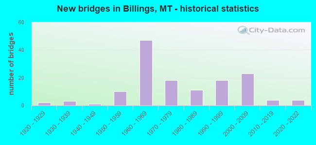
- New bridges - historical statistics
- 21920-1929
- 31930-1939
- 11940-1949
- 101950-1959
- 471960-1969
- 181970-1979
- 111980-1989
- 181990-1999
- 232000-2009
- 42010-2019
- 42020-2022

- Reconstructed bridges - Historical Statistics
- 11950-1959
- 31960-1969
- 11970-1979
- 31980-1989
- 31990-1999
- 22000-2009


- Bridge Condition - Deck
- 1.9%Very good
- 36.4%Good
- 54.2%Satisfactory
- 6.5%Fair
- 0.9%Poor

- Bridge Condition - Superstructure
- 1.9%Very good
- 58.9%Good
- 34.6%Satisfactory
- 2.8%Fair
- 1.9%Poor

- Bridge Condition - Substructure
- 1.9%Very good
- 39.3%Good
- 47.7%Satisfactory
- 8.4%Fair
- 2.8%Poor

- Bridge Condition - Channel
- 22.6%Very good
- 45.2%Good
- 27.4%Satisfactory
- 2.4%Fair
- 2.4%Poor

- Bridge Condition - Culverts
- 11.1%Very good
- 33.3%Good
- 44.4%Satisfactory
- 11.1%Fair
Find on map >> Show street view
Structure Number: P00016000+00001, Location: BILLINGS (Lat: 45.796397, Lng: -108.456953), Route carried "on" structure: US 87, Year Built: 1966, Year Reconstructed: 1998, Status: Open, Structure Length: 8.41m (27.59ft), Average Daily Traffic: 21,677 (year 2020), Truck Traffic: 3%, Average Future Daily Traffic: 22,761 (year 2040), Design Load: HS 20, Features Intersected: INT LOCKWOOD I 90
Minimum Vertical Clearance: 30+ m (98+ ft), Kilometerpoint: 0.020, Lanes on structure: 4, Lanes under structure: 4, Base Highway Network: Yes, Owner: State Highway Agency, Approaching Roadway Width: 24.4m (80.1ft), Skew: 23 degrees, Material/Design: Prestressed concrete, Design/Construction: Stringer/Multi-beam, Number Of Spans In Main Unit: 5, Length of Maximum Span: 21.9m (71.9ft), Curb or Sidewalk Widths: Left: 1.0m (3.3ft), Right: 0.0m, Curb-To-Curb Width: 21.9m (71.9ft), Out-to-Out Width: 25.0m (82.0ft)
Condition: Deck: Good, Superstructure: Satisfactory, Substructure: Satisfactory, Operating Rating: 40.8 metric tons, Method Used To Determine Operating Rating: Load and Resistance Factor (LRFR), Inventory Rating: 15.4 metric tons, Method Used To Determine Inventory Rating: Load and Resistance Factor (LRFR), Structural Evaluation: High priority of corrective action, Deck Geometry: Superior to present desirable criteria, Underclear: Equal to present minimum criteria, Approach Roadway Alignment: Equal to present desirable criteria, Designated Inspection Frequency: Every 24 months, Inspection Date: April 2020, Deck Structure Type: Concrete Cast-file-Place, Wearing Surface/Protective System: Wearing Surface: Epoxy Overlay, Deck Protection: Epoxy Coated Reinforcing
Find on map >> Show street view
Structure Number: P00016000+04641, Location: BILLINGS (Lat: 45.796097, Lng: -108.465453), Route carried "on" structure: US 87, Year Built: 1993, Status: Open, Structure Length: 8.14m (26.71ft), Average Daily Traffic: 21,677 (year 2020), Truck Traffic: 3%, Average Future Daily Traffic: 22,761 (year 2040), Design Load: HS 20, Features Intersected: RR
Minimum Vertical Clearance: 30+ m (98+ ft), Kilometerpoint: 0.745, Lanes on structure: 4, Base Highway Network: Yes, Owner: State Highway Agency, Approaching Roadway Width: 20.7m (67.9ft), Skew: 34 degrees, Material/Design: Steel continuous, Design/Construction: Stringer/Multi-beam, Number Of Spans In Main Unit: 3, Length of Maximum Span: 36.6m (120.1ft), Curb or Sidewalk Widths: Left: 1.5m (4.9ft), Right: 0.0m, Curb-To-Curb Width: 20.7m (67.9ft), Out-to-Out Width: 27.7m (90.9ft)
Condition: Deck: Satisfactory, Superstructure: Good, Substructure: Satisfactory, Operating Rating: 47.2 metric tons, Method Used To Determine Operating Rating: Load Factor (LF), Inventory Rating: 28.1 metric tons, Method Used To Determine Inventory Rating: Load Factor (LF), Structural Evaluation: Equal to present minimum criteria, Deck Geometry: Superior to present desirable criteria, Underclear: Equal to present minimum criteria, Approach Roadway Alignment: Equal to present minimum criteria, Designated Inspection Frequency: Every 24 months, Inspection Date: May 2020, Deck Structure Type: Concrete Cast-file-Place, Wearing Surface/Protective System: Wearing Surface: Monolithic Concrete, Deck Protection: Epoxy Coated Reinforcing
Find on map >> Show street view
Structure Number: P00016000+06721, Location: BILLINGS-DICK JOHNSTON BR (Lat: 45.796475, Lng: -108.469842), Route carried "on" structure: US 87, Year Built: 1993, Status: Open, Structure Length: 17.25m (56.59ft), Average Daily Traffic: 21,677 (year 2020), Truck Traffic: 3%, Average Future Daily Traffic: 22,761 (year 2040), Design Load: HS 20, Features Intersected: YELLOWSTONE RIVER
Minimum Vertical Clearance: 30+ m (98+ ft), Kilometerpoint: 1.104, Lanes on structure: 4, Base Highway Network: Yes, Owner: State Highway Agency, Approaching Roadway Width: 20.7m (67.9ft), Skew: 30 degrees, Material/Design: Prestressed concrete, Design/Construction: Stringer/Multi-beam, Number Of Spans In Main Unit: 5, Length of Maximum Span: 34.4m (112.9ft), Curb or Sidewalk Widths: Left: 0.0m, Right: 2.3m (7.5ft), Curb-To-Curb Width: 20.7m (67.9ft), Out-to-Out Width: 27.7m (90.9ft)
Condition: Deck: Satisfactory, Superstructure: Good, Substructure: Satisfactory, Channel: Good, Operating Rating: 42.6 metric tons, Method Used To Determine Operating Rating: Load and Resistance Factor (LRFR), Inventory Rating: 23.6 metric tons, Method Used To Determine Inventory Rating: Load and Resistance Factor (LRFR), Structural Evaluation: Somewhat better than minimum adequacy, Deck Geometry: Superior to present desirable criteria, Waterway Adequacy: Superior to present desirable criteria, Approach Roadway Alignment: Equal to present desirable criteria, Designated Inspection Frequency: Every 24 months, Underwater Inspection Frequency: Every 60 months, Inspection Date: August 2021, Underwater Inspection Date: August 2020, Deck Structure Type: Concrete Cast-file-Place, Wearing Surface/Protective System: Wearing Surface: Monolithic Concrete, Deck Protection: Epoxy Coated Reinforcing
Find on map >> Show street view
Structure Number: P00016005+01671, Location: 2M N BILLINGS (Lat: 45.847778, Lng: -108.466186), Route carried "on" structure: US 87, Year Built: 1977, Status: Open, Structure Length: 2.38m (7.81ft), Average Daily Traffic: 5,667 (year 2020), Truck Traffic: 3%, Average Future Daily Traffic: 5,950 (year 2040), Design Load: HS 20, Features Intersected: FIVE MILE CREEK
Minimum Vertical Clearance: 30+ m (98+ ft), Kilometerpoint: 8.278, Lanes on structure: 2, Base Highway Network: Yes, Owner: State Highway Agency, Approaching Roadway Width: 13.7m (44.9ft), Skew: 1 degrees, Material/Design: Prestressed concrete, Design/Construction: Stringer/Multi-beam, Number Of Spans In Main Unit: 1, Length of Maximum Span: 22.9m (75.1ft), Curb or Sidewalk Widths: Left: 0.1m (0.3ft), Right: 0.1m (0.3ft), Curb-To-Curb Width: 13.3m (43.6ft), Out-to-Out Width: 14.1m (46.3ft)
Condition: Deck: Good, Superstructure: Good, Substructure: Good, Channel: Good, Operating Rating: 47.2 metric tons, Method Used To Determine Operating Rating: Load and Resistance Factor (LRFR), Inventory Rating: 29.9 metric tons, Method Used To Determine Inventory Rating: Load and Resistance Factor (LRFR), Structural Evaluation: Better than present minimum criteria, Deck Geometry: Somewhat better than minimum adequacy, Waterway Adequacy: Equal to present desirable criteria, Approach Roadway Alignment: Equal to present desirable criteria, Designated Inspection Frequency: Every 24 months, Inspection Date: November 2020, Deck Structure Type: Concrete Cast-file-Place, Wearing Surface/Protective System: Wearing Surface: Monolithic Concrete
Find on map >> Show street view
Structure Number: P00016005+07311, Location: 3M N BILLINGS (Lat: 45.855908, Lng: -108.466697), Route carried "on" structure: US 87, Year Built: 1977, Status: Open, Structure Length: 1.92m (6.30ft), Average Daily Traffic: 5,667 (year 2020), Truck Traffic: 3%, Average Future Daily Traffic: 5,950 (year 2040), Design Load: HS 20, Features Intersected: BBWA CANAL
Minimum Vertical Clearance: 30+ m (98+ ft), Kilometerpoint: 9.185, Lanes on structure: 2, Base Highway Network: Yes, Owner: State Highway Agency, Approaching Roadway Width: 13.7m (44.9ft), Skew: 2 degrees, Material/Design: Prestressed concrete, Design/Construction: Stringer/Multi-beam, Number Of Spans In Main Unit: 1, Length of Maximum Span: 18.3m (60.0ft), Curb or Sidewalk Widths: Left: 0.1m (0.3ft), Right: 0.1m (0.3ft), Curb-To-Curb Width: 13.3m (43.6ft), Out-to-Out Width: 14.1m (46.3ft)
Condition: Deck: Good, Superstructure: Good, Substructure: Good, Channel: Good, Operating Rating: 39.9 metric tons, Method Used To Determine Operating Rating: Load and Resistance Factor (LRFR), Inventory Rating: 30.8 metric tons, Method Used To Determine Inventory Rating: Load and Resistance Factor (LRFR), Structural Evaluation: Better than present minimum criteria, Deck Geometry: Somewhat better than minimum adequacy, Waterway Adequacy: Superior to present desirable criteria, Approach Roadway Alignment: Equal to present desirable criteria, Designated Inspection Frequency: Every 24 months, Inspection Date: November 2020, Deck Structure Type: Concrete Cast-file-Place, Wearing Surface/Protective System: Wearing Surface: Monolithic Concrete
Find on map >> Show street view
Structure Number: P00053000+00001, Location: BILLINGS-S 27TH ST (Lat: 45.767661, Lng: -108.487264), Route carried "on" structure: State highway 3, Year Built: 1966, Status: Open, Structure Length: 6.73m (22.08ft), Average Daily Traffic: 11,302 (year 2020), Average Future Daily Traffic: 11,867 (year 2040), Design Load: HS 20, Features Intersected: INT 27TH ST I 90, Facility Carried by Structure: S 27TH ST
Minimum Vertical Clearance: 30+ m (98+ ft), Kilometerpoint: 0.014, Lanes on structure: 4, Lanes under structure: 4, Base Highway Network: Yes, Owner: State Highway Agency, Approaching Roadway Width: 8.5m (27.9ft), Skew: 20 degrees, Material/Design: Prestressed concrete, Design/Construction: Stringer/Multi-beam, Number Of Spans In Main Unit: 4, Length of Maximum Span: 20.4m (66.9ft), Curb or Sidewalk Widths: Left: 1.5m (4.9ft), Right: 1.5m (4.9ft), Curb-To-Curb Width: 17.1m (56.1ft), Out-to-Out Width: 22.0m (72.2ft)
Condition: Deck: Fair, Superstructure: Satisfactory, Substructure: Satisfactory, Operating Rating: 49.9 metric tons, Method Used To Determine Operating Rating: Load and Resistance Factor (LRFR), Inventory Rating: 38.1 metric tons, Method Used To Determine Inventory Rating: Load and Resistance Factor (LRFR), Structural Evaluation: Equal to present minimum criteria, Deck Geometry: Somewhat better than minimum adequacy, Underclear: High priority of corrective action, Approach Roadway Alignment: Somewhat better than minimum adequacy, Designated Inspection Frequency: Every 24 months, Inspection Date: April 2020, Deck Structure Type: Concrete Cast-file-Place, Wearing Surface/Protective System: Wearing Surface: Latex Concrete
Find on map >> Show street view
Structure Number: P00053002+01251, Location: BILLINGS-N 27TH ST (Lat: 45.796369, Lng: -108.518000), Route carried "on" structure: State highway 3, Year Built: 1947, Year Reconstructed: 1963, Status: Open, Structure Length: 1.13m (3.71ft), Average Daily Traffic: 3,490 (year 2020), Truck Traffic: 1%, Average Future Daily Traffic: 3,665 (year 2040), Design Load: HS 15, Features Intersected: BBWA CANAL, Facility Carried by Structure: N 27TH ST
Minimum Vertical Clearance: 30+ m (98+ ft), Kilometerpoint: 4.039, Lanes on structure: 4, Base Highway Network: Yes, Owner: State Highway Agency, Approaching Roadway Width: 15.2m (49.9ft), Skew: 2 degrees, Material/Design: Wood or Timber, Design/Construction: Stringer/Multi-beam, Number Of Spans In Main Unit: 1, Length of Maximum Span: 11.3m (37.1ft), Curb or Sidewalk Widths: Left: 1.2m (3.9ft), Right: 1.2m (3.9ft), Curb-To-Curb Width: 19.6m (64.3ft), Out-to-Out Width: 22.1m (72.5ft)
Condition: Deck: Satisfactory, Superstructure: Satisfactory, Substructure: Satisfactory, Channel: Good, Operating Rating: 40.8 metric tons, Method Used To Determine Operating Rating: Allowable Stress (AS), Inventory Rating: 24.4 metric tons, Method Used To Determine Inventory Rating: Allowable Stress (AS), Structural Evaluation: Equal to present minimum criteria, Deck Geometry: Better than present minimum criteria, Waterway Adequacy: Superior to present desirable criteria, Approach Roadway Alignment: Equal to present desirable criteria, Designated Inspection Frequency: Every 24 months, Inspection Date: November 2020, Deck Structure Type: Concrete Cast-file-Place, Wearing Surface/Protective System: Wearing Surface: Bituminous
Find on map >> Show street view
Structure Number: P00053011+09351, Location: 8M NW BILLINGS (Lat: 45.868631, Lng: -108.661319), Route carried "on" structure: State highway 3, Year Built: 1992, Status: Open, Structure Length: 0.73m (2.40ft), Average Daily Traffic: 2,889 (year 2020), Truck Traffic: 10%, Average Future Daily Traffic: 3,033 (year 2040), Design Load: HL 93, Features Intersected: NORTH FORK ALKALI CREEK
Minimum Vertical Clearance: 30+ m (98+ ft), Kilometerpoint: 19.833, Lanes on structure: 2, Base Highway Network: Yes, Owner: State Highway Agency, Approaching Roadway Width: 13.4m (44.0ft), Skew: 1 degrees, Material/Design: Steel, Design/Construction: Culvert, Number Of Spans In Main Unit: 2, Length of Maximum Span: 3.0m (9.8ft)
Condition: Channel: Very good, Culverts: Satisfactory, Operating Rating: 89.8 metric tons, Method Used To Determine Operating Rating: Load and Resistance Factor (LRFR), Inventory Rating: 89.8 metric tons, Method Used To Determine Inventory Rating: Load and Resistance Factor (LRFR), Structural Evaluation: Equal to present minimum criteria, Waterway Adequacy: Superior to present desirable criteria, Approach Roadway Alignment: Equal to present desirable criteria, Designated Inspection Frequency: Every 24 months, Inspection Date: November 2020
Find on map >> Show street view
Structure Number: S00416000+03691, Location: 1M S BILLINGS (Lat: 45.736964, Lng: -108.533839), Route carried "on" structure: State highway 1033, Year Built: 1972, Status: Open, Structure Length: 26.24m (86.09ft), Average Daily Traffic: 8,510 (year 2020), Average Future Daily Traffic: 8,936 (year 2040), Design Load: HS 20, Features Intersected: YELLOWSTONE RIVER, Facility Carried by Structure: S BILLINGS BLVD
Minimum Vertical Clearance: 30+ m (98+ ft), Kilometerpoint: 1.688, Lanes on structure: 2, Owner: State Highway Agency, Approaching Roadway Width: 7.3m (24.0ft), Material/Design: Steel continuous, Design/Construction: Stringer/Multi-beam, Number Of Spans In Main Unit: 5, Length of Maximum Span: 57.0m (187.0ft), Curb or Sidewalk Widths: Left: 1.2m (3.9ft), Right: 0.0m, Curb-To-Curb Width: 10.9m (35.8ft), Out-to-Out Width: 13.2m (43.3ft)
Condition: Deck: Fair, Superstructure: Satisfactory, Substructure: Satisfactory, Channel: Satisfactory, Operating Rating: 40.8 metric tons, Method Used To Determine Operating Rating: Load and Resistance Factor (LRFR), Inventory Rating: 31.8 metric tons, Method Used To Determine Inventory Rating: Load and Resistance Factor (LRFR), Structural Evaluation: Equal to present minimum criteria, Deck Geometry: Meets minimum limits, Waterway Adequacy: Equal to present desirable criteria, Approach Roadway Alignment: Equal to present desirable criteria, Designated Inspection Frequency: Every 24 months, Underwater Inspection Frequency: Every 60 months, Inspection Date: July 2020, Underwater Inspection Date: September 2020, Deck Structure Type: Concrete Cast-file-Place, Wearing Surface/Protective System: Wearing Surface: Monolithic Concrete
Find on map >> Show street view
Structure Number: S00416000+09591, Location: 2M S BILLINGS (Lat: 45.727444, Lng: -108.532733), Route carried "on" structure: State highway 1033, Year Built: 1972, Status: Open, Structure Length: 3.66m (12.01ft), Average Daily Traffic: 8,510 (year 2020), Average Future Daily Traffic: 8,936 (year 2040), Design Load: HS 20, Features Intersected: BLUE CREEK, Facility Carried by Structure: BLUE CREEK RD
Minimum Vertical Clearance: 30+ m (98+ ft), Kilometerpoint: 2.763, Lanes on structure: 2, Owner: State Highway Agency, Approaching Roadway Width: 10.4m (34.1ft), Material/Design: Prestressed concrete, Design/Construction: Stringer/Multi-beam, Number Of Spans In Main Unit: 3, Length of Maximum Span: 16.8m (55.1ft), Curb or Sidewalk Widths: Left: 0.2m (0.7ft), Right: 0.2m (0.7ft), Curb-To-Curb Width: 10.8m (35.4ft), Out-to-Out Width: 11.6m (38.1ft)
Condition: Deck: Good, Superstructure: Good, Substructure: Satisfactory, Channel: Good, Operating Rating: 50.8 metric tons, Method Used To Determine Operating Rating: Load and Resistance Factor (LRFR), Inventory Rating: 33.6 metric tons, Method Used To Determine Inventory Rating: Load and Resistance Factor (LRFR), Structural Evaluation: Equal to present minimum criteria, Deck Geometry: Meets minimum limits, Waterway Adequacy: Superior to present desirable criteria, Approach Roadway Alignment: Somewhat better than minimum adequacy, Length Of Structure Improvement: 4.60m (15.09ft), Designated Inspection Frequency: Every 24 months, Inspection Date: December 2020, Bridge Improvement Cost: $253,000, Roadway Improvement Cost: $25,000, Total Project Cost: $279,000, Deck Structure Type: Concrete Cast-file-Place, Wearing Surface/Protective System: Wearing Surface: Monolithic Concrete
Find on map >> Show street view
Structure Number: S00416007+04001, Location: 7M S BILLINGS (Lat: 45.655261, Lng: -108.498278), Route carried "on" structure: State highway 416, Year Built: 1982, Status: Open, Structure Length: 0.91m (2.99ft), Average Daily Traffic: 624 (year 2020), Truck Traffic: 2%, Average Future Daily Traffic: 655 (year 2040), Design Load: HL 93, Features Intersected: BLUE CREEK, Facility Carried by Structure: BLUE CREEK RD
Minimum Vertical Clearance: 30+ m (98+ ft), Kilometerpoint: 13.062, Lanes on structure: 2, Owner: State Highway Agency, Approaching Roadway Width: 11.6m (38.1ft), Material/Design: Steel, Design/Construction: Culvert, Number Of Spans In Main Unit: 2, Length of Maximum Span: 4.0m (13.1ft)
Condition: Channel: Satisfactory, Culverts: Good, Operating Rating: 89.8 metric tons, Method Used To Determine Operating Rating: Load and Resistance Factor (LRFR), Inventory Rating: 78.9 metric tons, Method Used To Determine Inventory Rating: Load and Resistance Factor (LRFR), Structural Evaluation: Better than present minimum criteria, Waterway Adequacy: Equal to present desirable criteria, Approach Roadway Alignment: Equal to present desirable criteria, Designated Inspection Frequency: Every 24 months, Inspection Date: January 2021
Find on map >> Show street view
Structure Number: S00429001+08501, Location: W BILLINGS (Lat: 45.726483, Lng: -108.614944), Route carried "on" structure: Bypass City street 1011, Year Built: 1959, Status: Open, Structure Length: 4.75m (15.58ft), Average Daily Traffic: 4,872 (year 2020), Truck Traffic: 2%, Average Future Daily Traffic: 5,116 (year 2040), Design Load: HS 20, Features Intersected: CANYON CREEK, Facility Carried by Structure: S FRONTAGE RD
Minimum Vertical Clearance: 30+ m (98+ ft), Kilometerpoint: 5.471, Lanes on structure: 2, Owner: State Highway Agency, Approaching Roadway Width: 9.4m (30.8ft), Material/Design: Prestressed concrete, Design/Construction: Stringer/Multi-beam, Number Of Spans In Main Unit: 3, Length of Maximum Span: 15.8m (51.8ft), Curb-To-Curb Width: 8.5m (27.9ft), Out-to-Out Width: 9.4m (30.8ft)
Condition: Deck: Satisfactory, Superstructure: Good, Substructure: Good, Channel: Satisfactory, Operating Rating: 47.1 metric tons, Method Used To Determine Operating Rating: Assigned rating based on Load Factor Design (LFD) reported in metric tons, Inventory Rating: 32.7 metric tons, Method Used To Determine Inventory Rating: Assigned rating based on Load Factor Design (LFD) reported in metric tons, Structural Evaluation: Better than present minimum criteria, Deck Geometry: Meets minimum limits, Waterway Adequacy: Superior to present desirable criteria, Approach Roadway Alignment: Equal to present desirable criteria, Length Of Structure Improvement: 5.80m (19.03ft), Designated Inspection Frequency: Every 24 months, Inspection Date: October 2021, Bridge Improvement Cost: $285,000, Roadway Improvement Cost: $143,000, Total Project Cost: $428,000, Deck Structure Type: Concrete Cast-file-Place, Wearing Surface/Protective System: Wearing Surface: Bituminous
Find on map >> Show street view
Structure Number: S00429002+02661, Location: 2M SW BILLINGS (Lat: 45.725678, Lng: -108.617519), Route carried "on" structure: City street 1031, Year Built: 1959, Status: Open, Structure Length: 13.93m (45.70ft), Average Daily Traffic: 1,984 (year 2020), Truck Traffic: 2%, Average Future Daily Traffic: 2,083 (year 2040), Design Load: HS 20, Features Intersected: SEP I 90, Facility Carried by Structure: S SHILOH RD
Minimum Vertical Clearance: 30+ m (98+ ft), Kilometerpoint: 8.313, Lanes on structure: 2, Lanes under structure: 4, Owner: State Highway Agency, Approaching Roadway Width: 9.1m (29.9ft), Material/Design: Prestressed concrete, Design/Construction: Stringer/Multi-beam, Number Of Spans In Main Unit: 9, Length of Maximum Span: 18.9m (62.0ft), Curb or Sidewalk Widths: Left: 0.5m (1.6ft), Right: 0.5m (1.6ft), Curb-To-Curb Width: 8.5m (27.9ft), Out-to-Out Width: 9.7m (31.8ft)
Condition: Deck: Poor, Superstructure: Fair, Substructure: Poor, Operating Rating: 40.8 metric tons, Method Used To Determine Operating Rating: Load and Resistance Factor (LRFR), Inventory Rating: 24.5 metric tons, Method Used To Determine Inventory Rating: Load and Resistance Factor (LRFR), Structural Evaluation: Meets minimum limits, Deck Geometry: Somewhat better than minimum adequacy, Underclear: Equal to present minimum criteria, Approach Roadway Alignment: Equal to present minimum criteria, Designated Inspection Frequency: Every 24 months, Inspection Date: April 2021, Deck Structure Type: Concrete Cast-file-Place, Wearing Surface/Protective System: Wearing Surface: Monolithic Concrete
Find on map >> Show street view
Structure Number: S00429002+06061, Location: 2M SW BILLINGS (Lat: 45.729794, Lng: -108.619536), Route carried "on" structure: City street 1031, Year Built: 1959, Status: Open, Structure Length: 4.66m (15.29ft), Average Daily Traffic: 3,302 (year 2020), Truck Traffic: 1%, Average Future Daily Traffic: 3,467 (year 2040), Design Load: HS 15, Features Intersected: CANYON CREEK, Facility Carried by Structure: S SHILOH RD
Minimum Vertical Clearance: 30+ m (98+ ft), Kilometerpoint: 7.764, Lanes on structure: 2, Owner: State Highway Agency, Approaching Roadway Width: 7.9m (25.9ft), Material/Design: Prestressed concrete, Design/Construction: Stringer/Multi-beam, Number Of Spans In Main Unit: 3, Length of Maximum Span: 15.8m (51.8ft), Curb-To-Curb Width: 8.5m (27.9ft), Out-to-Out Width: 9.7m (31.8ft)
Condition: Deck: Good, Superstructure: Satisfactory, Substructure: Fair, Channel: Good, Operating Rating: 47.1 metric tons, Method Used To Determine Operating Rating: Allowable Stress (AS), Inventory Rating: 24.4 metric tons, Method Used To Determine Inventory Rating: Allowable Stress (AS), Structural Evaluation: Somewhat better than minimum adequacy, Deck Geometry: Meets minimum limits, Waterway Adequacy: Equal to present desirable criteria, Approach Roadway Alignment: Better than present minimum criteria, Length Of Structure Improvement: 5.70m (18.70ft), Designated Inspection Frequency: Every 24 months, Inspection Date: June 2021, Bridge Improvement Cost: $288,000, Roadway Improvement Cost: $144,000, Total Project Cost: $432,000, Deck Structure Type: Concrete Cast-file-Place, Wearing Surface/Protective System: Wearing Surface: Bituminous
Find on map >> Show street view
Structure Number: S00429003+03271, Location: 2M W BILLINGS (Lat: 45.739861, Lng: -108.617425), Route carried "on" structure: City street 116, Year Built: 2000, Status: Open, Structure Length: 1.40m (4.59ft), Average Daily Traffic: 9,589 (year 2020), Truck Traffic: 4%, Average Future Daily Traffic: 11,267 (year 2040), Design Load: HS 20, Features Intersected: BBWA CANAL, Facility Carried by Structure: S SHILOH RD
Minimum Vertical Clearance: 30+ m (98+ ft), Kilometerpoint: 6.601, Lanes on structure: 4, Base Highway Network: Yes, Owner: City or Municipal Highway Agency, Approaching Roadway Width: 11.0m (36.1ft), Skew: 13 degrees, Material/Design: Prestressed concrete, Design/Construction: Tee Beam, Number Of Spans In Main Unit: 1, Length of Maximum Span: 12.2m (40.0ft), Curb or Sidewalk Widths: Left: 3.0m (9.8ft), Right: 1.5m (4.9ft), Curb-To-Curb Width: 11.0m (36.1ft), Out-to-Out Width: 25.1m (82.3ft)
Condition: Deck: Satisfactory, Superstructure: Good, Substructure: Good, Channel: Good, Operating Rating: 65.5 metric tons, Method Used To Determine Operating Rating: Load Factor (LF), Inventory Rating: 39.3 metric tons, Method Used To Determine Inventory Rating: Load Factor (LF), Structural Evaluation: Better than present minimum criteria, Deck Geometry: High priority of replacement, Waterway Adequacy: Equal to present desirable criteria, Approach Roadway Alignment: Somewhat better than minimum adequacy, Designated Inspection Frequency: Every 24 months, Inspection Date: December 2020, Deck Structure Type: Concrete Precast Panels
Find on map >> Show street view
Structure Number: S00532009+06001, Location: 6M W BILLINGS (Lat: 45.760150, Lng: -108.741156), Route carried "on" structure: State highway 532, Year Built: 1975, Status: Open, Structure Length: 1.92m (6.30ft), Average Daily Traffic: 790 (year 2020), Truck Traffic: 1%, Average Future Daily Traffic: 833 (year 2040), Design Load: HS 15, Features Intersected: CANYON CREEK, Facility Carried by Structure: S 88TH ST W
Minimum Vertical Clearance: 30+ m (98+ ft), Kilometerpoint: 18.356, Lanes on structure: 2, Owner: State Highway Agency, Approaching Roadway Width: 6.4m (21.0ft), Material/Design: Prestressed concrete, Design/Construction: Tee Beam, Number Of Spans In Main Unit: 1, Length of Maximum Span: 18.9m (62.0ft), Curb-To-Curb Width: 7.1m (23.3ft), Out-to-Out Width: 7.3m (24.0ft)
Condition: Deck: Good, Superstructure: Good, Substructure: Good, Channel: Satisfactory, Operating Rating: 24.4 metric tons, Method Used To Determine Operating Rating: Allowable Stress (AS), Inventory Rating: 24.4 metric tons, Method Used To Determine Inventory Rating: Allowable Stress (AS), Structural Evaluation: Equal to present minimum criteria, Deck Geometry: Meets minimum limits, Waterway Adequacy: Superior to present desirable criteria, Approach Roadway Alignment: Better than present minimum criteria, Length Of Structure Improvement: 2.70m (8.86ft), Designated Inspection Frequency: Every 24 months, Inspection Date: December 2020, Bridge Improvement Cost: $90,000, Roadway Improvement Cost: $45,000, Total Project Cost: $135,000, Deck Structure Type: Concrete Precast Panels, Wearing Surface/Protective System: Wearing Surface: Bituminous
Find on map >> Show street view
Structure Number: S00532010+06381, Location: 5M W BILLINGS (Lat: 45.755222, Lng: -108.726733), Route carried "on" structure: State highway 532, Year Built: 1966, Status: Open, Structure Length: 1.89m (6.20ft), Average Daily Traffic: 790 (year 2020), Truck Traffic: 1%, Average Future Daily Traffic: 833 (year 2040), Features Intersected: CANYON CREEK, Facility Carried by Structure: KING AVE W
Minimum Vertical Clearance: 30+ m (98+ ft), Kilometerpoint: 19.776, Lanes on structure: 2, Owner: State Highway Agency, Approaching Roadway Width: 7.3m (24.0ft), Material/Design: Prestressed concrete, Design/Construction: Channel Beam, Number Of Spans In Main Unit: 1, Length of Maximum Span: 18.6m (61.0ft), Curb-To-Curb Width: 7.7m (25.3ft), Out-to-Out Width: 7.9m (25.9ft)
Condition: Deck: Good, Superstructure: Good, Substructure: Satisfactory, Channel: Fair, Operating Rating: 30.8 metric tons, Method Used To Determine Operating Rating: Load and Resistance Factor (LRFR), Inventory Rating: 24.5 metric tons, Method Used To Determine Inventory Rating: Load and Resistance Factor (LRFR), Structural Evaluation: Equal to present minimum criteria, Deck Geometry: Meets minimum limits, Waterway Adequacy: Superior to present desirable criteria, Approach Roadway Alignment: Somewhat better than minimum adequacy, Length Of Structure Improvement: 2.60m (8.53ft), Designated Inspection Frequency: Every 24 months, Inspection Date: December 2020, Bridge Improvement Cost: $95,000, Roadway Improvement Cost: $48,000, Total Project Cost: $143,000, Deck Structure Type: Concrete Precast Panels, Wearing Surface/Protective System: Wearing Surface: Bituminous
Find on map >> Show street view
Structure Number: U01003000+04501, Location: BILLINGS-17TH ST W (Lat: 45.790922, Lng: -108.559075), Route carried "on" structure: City street 1003, Year Built: 1974, Status: Open, Structure Length: 1.40m (4.59ft), Average Daily Traffic: 8,869 (year 2020), Average Future Daily Traffic: 9,312 (year 2040), Design Load: HS 20, Features Intersected: BBWA CANAL, Facility Carried by Structure: 17TH ST W
Minimum Vertical Clearance: 30+ m (98+ ft), Kilometerpoint: 0.755, Lanes on structure: 2, Owner: City or Municipal Highway Agency, Approaching Roadway Width: 14.6m (47.9ft), Skew: 2 degrees, Material/Design: Prestressed concrete, Design/Construction: Tee Beam, Number Of Spans In Main Unit: 1, Length of Maximum Span: 13.7m (44.9ft), Curb or Sidewalk Widths: Left: 1.8m (5.9ft), Right: 1.8m (5.9ft), Curb-To-Curb Width: 7.3m (24.0ft), Out-to-Out Width: 18.3m (60.0ft)
Condition: Deck: Good, Superstructure: Good, Substructure: Satisfactory, Channel: Satisfactory, Operating Rating: 51.7 metric tons, Method Used To Determine Operating Rating: Assigned rating based on Load Factor Design (LFD) reported in metric tons, Inventory Rating: 32.7 metric tons, Method Used To Determine Inventory Rating: Assigned rating based on Load Factor Design (LFD) reported in metric tons, Structural Evaluation: Equal to present minimum criteria, Deck Geometry: High priority of replacement, Waterway Adequacy: Superior to present desirable criteria, Approach Roadway Alignment: Somewhat better than minimum adequacy, Designated Inspection Frequency: Every 24 months, Inspection Date: November 2020, Deck Structure Type: Concrete Cast-file-Place, Wearing Surface/Protective System: Wearing Surface: Monolithic Concrete
Find on map >> Show street view
Structure Number: U01004001+08401, Location: BILLINGS-GRAND AVE (Lat: 45.784128, Lng: -108.579939), Route carried "on" structure: City street 1004, Year Built: 1981, Status: Open, Structure Length: 1.55m (5.09ft), Average Daily Traffic: 16,022 (year 2020), Average Future Daily Traffic: 16,983 (year 2040), Design Load: HS 20, Features Intersected: BBWA CANAL, Facility Carried by Structure: GRAND AVE
Minimum Vertical Clearance: 30+ m (98+ ft), Kilometerpoint: 2.946, Lanes on structure: 4, Owner: City or Municipal Highway Agency, Approaching Roadway Width: 18.9m (62.0ft), Skew: 1 degrees, Material/Design: Concrete continuous, Design/Construction: Slab, Number Of Spans In Main Unit: 2, Length of Maximum Span: 7.6m (24.9ft), Curb or Sidewalk Widths: Left: 1.7m (5.6ft), Right: 1.7m (5.6ft), Curb-To-Curb Width: 18.7m (61.4ft), Out-to-Out Width: 22.9m (75.1ft)
Condition: Deck: Satisfactory, Superstructure: Good, Substructure: Satisfactory, Channel: Satisfactory, Operating Rating: 77.1 metric tons, Method Used To Determine Operating Rating: Load Factor (LF), Inventory Rating: 46.3 metric tons, Method Used To Determine Inventory Rating: Load Factor (LF), Structural Evaluation: Equal to present minimum criteria, Deck Geometry: Equal to present minimum criteria, Waterway Adequacy: Equal to present minimum criteria, Approach Roadway Alignment: Equal to present desirable criteria, Designated Inspection Frequency: Every 24 months, Inspection Date: November 2020, Deck Structure Type: Concrete Cast-file-Place, Wearing Surface/Protective System: Wearing Surface: Monolithic Concrete
Find on map >> Show street view
Structure Number: U01006001+05001, Location: BILLINGS-BROADWATER AVE (Lat: 45.776972, Lng: -108.586794), Route carried "on" structure: City street 1006, Year Built: 1984, Status: Open, Structure Length: 1.62m (5.31ft), Average Daily Traffic: 9,364 (year 2020), Average Future Daily Traffic: 9,832 (year 2040), Design Load: HS 20, Features Intersected: BBWA CANAL, Facility Carried by Structure: BROADWATER AVE
Minimum Vertical Clearance: 30+ m (98+ ft), Kilometerpoint: 2.405, Lanes on structure: 4, Owner: City or Municipal Highway Agency, Approaching Roadway Width: 19.2m (63.0ft), Material/Design: Prestressed concrete, Design/Construction: Tee Beam, Number Of Spans In Main Unit: 1, Length of Maximum Span: 9.4m (30.8ft), Curb or Sidewalk Widths: Left: 1.7m (5.6ft), Right: 1.7m (5.6ft), Curb-To-Curb Width: 19.3m (63.3ft), Out-to-Out Width: 22.7m (74.5ft)
Condition: Deck: Satisfactory, Superstructure: Good, Substructure: Good, Channel: Good, Operating Rating: 32.7 metric tons, Method Used To Determine Operating Rating: Assigned rating based on Load Factor Design (LFD) reported in metric tons, Inventory Rating: 32.7 metric tons, Method Used To Determine Inventory Rating: Assigned rating based on Load Factor Design (LFD) reported in metric tons, Structural Evaluation: Better than present minimum criteria, Deck Geometry: Equal to present minimum criteria, Waterway Adequacy: Superior to present desirable criteria, Approach Roadway Alignment: Equal to present desirable criteria, Designated Inspection Frequency: Every 24 months, Inspection Date: November 2021, Deck Structure Type: Concrete Cast-file-Place, Wearing Surface/Protective System: Wearing Surface: Monolithic Concrete
Find on map >> Show street view
Structure Number: U01008001+07501, Location: BILLINGS-CENTRAL AVE (Lat: 45.769744, Lng: -108.586511), Route carried "on" structure: City street 1008, Year Built: 1978, Status: Open, Structure Length: 1.62m (5.31ft), Average Daily Traffic: 17,417 (year 2020), Average Future Daily Traffic: 18,985 (year 2040), Design Load: HS 20, Features Intersected: BBWA CANAL, Facility Carried by Structure: CENTRAL AVE
Minimum Vertical Clearance: 30+ m (98+ ft), Kilometerpoint: 2.421, Lanes on structure: 2, Owner: City or Municipal Highway Agency, Approaching Roadway Width: 20.1m (65.9ft), Skew: 1 degrees, Material/Design: Prestressed concrete, Design/Construction: Stringer/Multi-beam, Number Of Spans In Main Unit: 1, Length of Maximum Span: 14.9m (48.9ft), Curb or Sidewalk Widths: Left: 1.6m (5.2ft), Right: 1.6m (5.2ft), Curb-To-Curb Width: 16.5m (54.1ft), Out-to-Out Width: 24.7m (81.0ft)
Condition: Deck: Satisfactory, Superstructure: Good, Substructure: Good, Channel: Good, Operating Rating: 32.7 metric tons, Method Used To Determine Operating Rating: Assigned rating based on Load Factor Design (LFD) reported in metric tons, Inventory Rating: 32.7 metric tons, Method Used To Determine Inventory Rating: Assigned rating based on Load Factor Design (LFD) reported in metric tons, Structural Evaluation: Better than present minimum criteria, Deck Geometry: Superior to present desirable criteria, Waterway Adequacy: Superior to present desirable criteria, Approach Roadway Alignment: Equal to present desirable criteria, Designated Inspection Frequency: Every 24 months, Inspection Date: November 2021, Deck Structure Type: Concrete Precast Panels, Wearing Surface/Protective System: Wearing Surface: Monolithic Concrete
Find on map >> Show street view
Structure Number: U01010001+03751, Location: BILLINGS-KING AVE W (Lat: 45.755236, Lng: -108.588819), Route carried "on" structure: City street 111, Year Built: 1994, Status: Open, Structure Length: 1.58m (5.18ft), Average Daily Traffic: 25,033 (year 2020), Average Future Daily Traffic: 26,285 (year 2040), Design Load: HS 20, Features Intersected: BBWA CANAL, Facility Carried by Structure: KING AVE W
Minimum Vertical Clearance: 30+ m (98+ ft), Kilometerpoint: 2.255, Lanes on structure: 4, Owner: State Highway Agency, Approaching Roadway Width: 10.4m (34.1ft), Skew: 32 degrees, Material/Design: Prestressed concrete, Design/Construction: Tee Beam, Number Of Spans In Main Unit: 1, Length of Maximum Span: 15.8m (51.8ft), Curb or Sidewalk Widths: Left: 2.3m (7.5ft), Right: 2.3m (7.5ft), Curb-To-Curb Width: 21.2m (69.6ft), Out-to-Out Width: 25.8m (84.6ft)
Condition: Deck: Satisfactory, Superstructure: Satisfactory, Substructure: Good, Channel: Very good, Operating Rating: 54.4 metric tons, Method Used To Determine Operating Rating: Load Factor (LF), Inventory Rating: 29.9 metric tons, Method Used To Determine Inventory Rating: Load Factor (LF), Structural Evaluation: Equal to present minimum criteria, Deck Geometry: Superior to present desirable criteria, Waterway Adequacy: Superior to present desirable criteria, Approach Roadway Alignment: Equal to present desirable criteria, Designated Inspection Frequency: Every 24 months, Inspection Date: November 2021, Deck Structure Type: Concrete Cast-file-Place, Wearing Surface/Protective System: Wearing Surface: Monolithic Concrete
Find on map >> Show street view
Structure Number: U01010002+06981, Location: BILLINGS-MULLOWNEY LN (Lat: 45.753008, Lng: -108.562306), Route carried "on" structure: City street 111, Year Built: 2007, Status: Open, Structure Length: 4.90m (16.08ft), Average Daily Traffic: 35,755 (year 2020), Average Future Daily Traffic: 37,543 (year 2040), Design Load: HS 25 or greater, Features Intersected: RR, Facility Carried by Structure: MULLOWNEY LN
Minimum Vertical Clearance: 30+ m (98+ ft), Kilometerpoint: 4.396, Lanes on structure: 2, Owner: State Highway Agency, Approaching Roadway Width: 16.4m (53.8ft), Material/Design: Prestressed concrete, Design/Construction: Stringer/Multi-beam, Number Of Spans In Main Unit: 2, Length of Maximum Span: 17.2m (56.4ft), Curb-To-Curb Width: 13.8m (45.3ft), Out-to-Out Width: 14.4m (47.2ft)
Condition: Deck: Good, Superstructure: Good, Substructure: Good, Operating Rating: 69.8 metric tons, Method Used To Determine Operating Rating: Load Factor (LF), Inventory Rating: 47.5 metric tons, Method Used To Determine Inventory Rating: Load Factor (LF), Structural Evaluation: Better than present minimum criteria, Deck Geometry: Superior to present desirable criteria, Underclear: Meets minimum limits, Approach Roadway Alignment: Equal to present desirable criteria, Length Of Structure Improvement: 6.90m (22.64ft), Designated Inspection Frequency: Every 48 months, Inspection Date: October 2019, Bridge Improvement Cost: $362,000, Roadway Improvement Cost: $181,000, Total Project Cost: $543,000, Deck Structure Type: Concrete Cast-file-Place, Wearing Surface/Protective System: Wearing Surface: Monolithic Concrete
Find on map >> Show street view
Structure Number: U01010002+06982, Location: BILLINGS-MULLOWNEY LN (Lat: 45.753183, Lng: -108.562203), Route carried "on" structure: City street 111, Year Built: 2007, Status: Open, Structure Length: 4.92m (16.14ft), Average Daily Traffic: 35,755 (year 2020), Average Future Daily Traffic: 37,543 (year 2040), Design Load: HS 25 or greater, Features Intersected: RR, Facility Carried by Structure: MULLOWNEY LN
Minimum Vertical Clearance: 30+ m (98+ ft), Kilometerpoint: 4.395, Lanes on structure: 2, Owner: State Highway Agency, Approaching Roadway Width: 13.7m (44.9ft), Material/Design: Prestressed concrete, Design/Construction: Stringer/Multi-beam, Number Of Spans In Main Unit: 2, Length of Maximum Span: 31.0m (101.7ft), Curb-To-Curb Width: 13.7m (44.9ft), Out-to-Out Width: 13.7m (44.9ft)
Condition: Deck: Satisfactory, Superstructure: Good, Substructure: Satisfactory, Operating Rating: 78.6 metric tons, Method Used To Determine Operating Rating: Load Factor (LF), Inventory Rating: 51.7 metric tons, Method Used To Determine Inventory Rating: Load Factor (LF), Structural Evaluation: Equal to present minimum criteria, Deck Geometry: Superior to present desirable criteria, Underclear: Meets minimum limits, Approach Roadway Alignment: Equal to present minimum criteria, Length Of Structure Improvement: 4.92m (16.14ft), Designated Inspection Frequency: Every 24 months, Inspection Date: October 2021, Bridge Improvement Cost: $364,000, Roadway Improvement Cost: $182,000, Total Project Cost: $546,000, Deck Structure Type: Concrete Cast-file-Place, Wearing Surface/Protective System: Wearing Surface: Monolithic Concrete
Find on map >> Show street view
Structure Number: U01010002+09211, Location: BILLINGS-MULLOWNEY LN (Lat: 45.751353, Lng: -108.558883), Route carried "on" structure: City street 111, Year Built: 2007, Status: Open, Structure Length: 5.23m (17.16ft), Average Daily Traffic: 35,755 (year 2020), Average Future Daily Traffic: 37,543 (year 2040), Design Load: HS 25 or greater, Features Intersected: LAUREL ROAD, Facility Carried by Structure: MULLOWNEY LN
Minimum Vertical Clearance: 30+ m (98+ ft), Kilometerpoint: 4.723, Lanes on structure: 2, Lanes under structure: 4, Owner: State Highway Agency, Approaching Roadway Width: 29.6m (97.1ft), Material/Design: Prestressed concrete, Design/Construction: Stringer/Multi-beam, Number Of Spans In Main Unit: 2, Length of Maximum Span: 26.0m (85.3ft), Curb-To-Curb Width: 29.6m (97.1ft), Out-to-Out Width: 31.3m (102.7ft)
Condition: Deck: Good, Superstructure: Good, Substructure: Satisfactory, Operating Rating: 62.9 metric tons, Method Used To Determine Operating Rating: Load Factor (LF), Inventory Rating: 49.1 metric tons, Method Used To Determine Inventory Rating: Load Factor (LF), Structural Evaluation: Equal to present minimum criteria, Deck Geometry: Superior to present desirable criteria, Underclear: Meets minimum limits, Approach Roadway Alignment: Meets minimum limits, Length Of Structure Improvement: 6.40m (21.00ft), Designated Inspection Frequency: Every 24 months, Inspection Date: October 2021, Bridge Improvement Cost: $538,000, Roadway Improvement Cost: $269,000, Total Project Cost: $807,000, Deck Structure Type: Concrete Cast-file-Place, Wearing Surface/Protective System: Wearing Surface: Monolithic Concrete
Find on map >> Show street view
Structure Number: U01011000+09321, Location: BILLINGS-S FRONTAGE RD (Lat: 45.748203, Lng: -108.570169), Route carried "on" structure: ServiceCity street 1011, Year Built: 1958, Status: Open, Structure Length: 2.56m (8.40ft), Average Daily Traffic: 5,649 (year 2020), Truck Traffic: 3%, Average Future Daily Traffic: 5,931 (year 2040), Features Intersected: HOGAN`S SLOUGH, Facility Carried by Structure: S FRONTAGE RD
Minimum Vertical Clearance: 30+ m (98+ ft), Kilometerpoint: 1.134, Lanes on structure: 2, Owner: State Highway Agency, Approaching Roadway Width: 8.5m (27.9ft), Material/Design: Prestressed concrete, Design/Construction: Stringer/Multi-beam, Number Of Spans In Main Unit: 2, Length of Maximum Span: 12.5m (41.0ft), Curb or Sidewalk Widths: Left: 0.1m (0.3ft), Right: 0.1m (0.3ft), Curb-To-Curb Width: 8.5m (27.9ft), Out-to-Out Width: 9.1m (29.9ft)
Condition: Deck: Satisfactory, Superstructure: Satisfactory, Substructure: Satisfactory, Channel: Satisfactory, Operating Rating: 51.7 metric tons, Method Used To Determine Operating Rating: Allowable Stress (AS), Inventory Rating: 31.7 metric tons, Method Used To Determine Inventory Rating: Allowable Stress (AS), Structural Evaluation: Equal to present minimum criteria, Deck Geometry: High priority of replacement, Waterway Adequacy: Superior to present desirable criteria, Approach Roadway Alignment: Equal to present desirable criteria, Length Of Structure Improvement: 3.50m (11.48ft), Designated Inspection Frequency: Every 24 months, Inspection Date: November 2020, Bridge Improvement Cost: $148,000, Roadway Improvement Cost: $74,000, Total Project Cost: $222,000, Deck Structure Type: Concrete Cast-file-Place, Wearing Surface/Protective System: Wearing Surface: Bituminous
Find on map >> Show street view
Structure Number: U01012001+01501, Location: BILLINGS-WICKS LN (Lat: 45.827386, Lng: -108.483850), Route carried "on" structure: City street 1012, Year Built: 1988, Status: Open, Structure Length: 1.49m (4.89ft), Average Daily Traffic: 12,927 (year 2020), Average Future Daily Traffic: 14,414 (year 2040), Design Load: HS 20, Features Intersected: BBWA CANAL, Facility Carried by Structure: WICKS LN
Minimum Vertical Clearance: 30+ m (98+ ft), Kilometerpoint: 1.770, Lanes on structure: 2, Owner: City or Municipal Highway Agency, Approaching Roadway Width: 19.5m (64.0ft), Material/Design: Prestressed concrete, Design/Construction: Tee Beam, Number Of Spans In Main Unit: 1, Length of Maximum Span: 14.6m (47.9ft), Curb or Sidewalk Widths: Left: 1.5m (4.9ft), Right: 1.5m (4.9ft), Curb-To-Curb Width: 19.5m (64.0ft), Out-to-Out Width: 22.6m (74.1ft)
Condition: Deck: Satisfactory, Superstructure: Good, Substructure: Good, Channel: Good, Operating Rating: 68.9 metric tons, Method Used To Determine Operating Rating: Load Factor (LF), Inventory Rating: 40.8 metric tons, Method Used To Determine Inventory Rating: Load Factor (LF), Structural Evaluation: Better than present minimum criteria, Deck Geometry: Superior to present desirable criteria, Waterway Adequacy: Equal to present desirable criteria, Approach Roadway Alignment: Equal to present desirable criteria, Designated Inspection Frequency: Every 24 months, Inspection Date: November 2021, Deck Structure Type: Concrete Precast Panels, Wearing Surface/Protective System: Wearing Surface: Monolithic Concrete
Find on map >> Show street view
Structure Number: U01013000+07771, Location: BILLINGS-S BILLINGS BLVD (Lat: 45.752242, Lng: -108.535653), Route carried "on" structure: City street 1013, Year Built: 1963, Year Reconstructed: 1992, Status: Open, Structure Length: 6.55m (21.49ft), Average Daily Traffic: 14,423 (year 2020), Truck Traffic: 2%, Average Future Daily Traffic: 15,144 (year 2040), Design Load: HS 20, Features Intersected: SEP BILLINGS BLVD-I 90, Facility Carried by Structure: S BILLINGS BLVD
Minimum Vertical Clearance: 30+ m (98+ ft), Kilometerpoint: 1.439, Lanes on structure: 2, Lanes under structure: 4, Owner: State Highway Agency, Approaching Roadway Width: 10.4m (34.1ft), Skew: 30 degrees, Material/Design: Prestressed concrete, Design/Construction: Stringer/Multi-beam, Number Of Spans In Main Unit: 4, Length of Maximum Span: 18.7m (61.4ft), Curb or Sidewalk Widths: Left: 0.0m, Right: 1.5m (4.9ft), Curb-To-Curb Width: 18.1m (59.4ft), Out-to-Out Width: 20.8m (68.2ft)
Condition: Deck: Satisfactory, Superstructure: Satisfactory, Substructure: Satisfactory, Operating Rating: 49.0 metric tons, Method Used To Determine Operating Rating: Load and Resistance Factor (LRFR), Inventory Rating: 30.8 metric tons, Method Used To Determine Inventory Rating: Load and Resistance Factor (LRFR), Structural Evaluation: Equal to present minimum criteria, Deck Geometry: Superior to present desirable criteria, Underclear: Meets minimum limits, Approach Roadway Alignment: Meets minimum limits, Designated Inspection Frequency: Every 24 months, Inspection Date: April 2021, Deck Structure Type: Concrete Cast-file-Place, Wearing Surface/Protective System: Wearing Surface: Monolithic Concrete, Deck Protection: Epoxy Coated Reinforcing
Find on map >> Show street view
Structure Number: U01014002+05171, Location: BILLINGS-E AIRPORT RD (Lat: 45.803358, Lng: -108.483606), Route carried "on" structure: Bypass City street 1014, Year Built: 2009, Status: Open, Structure Length: 4.30m (14.11ft), Average Daily Traffic: 13,972 (year 2020), Truck Traffic: 2%, Average Future Daily Traffic: 15,020 (year 2040), Design Load: HS 20+Mod, Features Intersected: 6TH AVE N BYPASS 21, Facility Carried by Structure: E AIRPORT RD
Minimum Vertical Clearance: 30+ m (98+ ft), Kilometerpoint: 4.161, Lanes on structure: 6, Lanes under structure: 3, Owner: State Highway Agency, Approaching Roadway Width: 30.0m (98.4ft), Skew: 2 degrees, Material/Design: Prestressed concrete, Design/Construction: Stringer/Multi-beam, Number Of Spans In Main Unit: 3, Length of Maximum Span: 25.0m (82.0ft), Curb-To-Curb Width: 30.2m (99.1ft), Out-to-Out Width: 31.0m (101.7ft)
Condition: Deck: Satisfactory, Superstructure: Good, Substructure: Good, Operating Rating: 54.3 metric tons, Method Used To Determine Operating Rating: Load and Resistance Factor (LRFR), Inventory Rating: 31.6 metric tons, Method Used To Determine Inventory Rating: Load and Resistance Factor (LRFR), Structural Evaluation: Better than present minimum criteria, Deck Geometry: Superior to present desirable criteria, Underclear: Meets minimum limits, Approach Roadway Alignment: Equal to present desirable criteria, Designated Inspection Frequency: Every 24 months, Inspection Date: August 2021, Deck Structure Type: Concrete Cast-file-Place, Wearing Surface/Protective System: Wearing Surface: Monolithic Concrete, Deck Protection: Epoxy Coated Reinforcing
Find on map >> Show street view
Structure Number: U01015001+07301, Location: BILLINGS-VIRGINIA LN (Lat: 45.795086, Lng: -108.527867), Route carried "on" structure: City street 1015, Year Built: 1988, Status: Open, Structure Length: 1.13m (3.71ft), Average Daily Traffic: 5,065 (year 2020), Truck Traffic: 1%, Average Future Daily Traffic: 5,318 (year 2040), Design Load: HS 20, Features Intersected: BBWA CANAL, Facility Carried by Structure: VIRGINIA LN
Minimum Vertical Clearance: 30+ m (98+ ft), Kilometerpoint: 2.772, Lanes on structure: 2, Owner: City or Municipal Highway Agency, Approaching Roadway Width: 12.5m (41.0ft), Material/Design: Concrete, Design/Construction: Slab, Number Of Spans In Main Unit: 2, Length of Maximum Span: 5.5m (18.0ft), Curb or Sidewalk Widths: Left: 1.8m (5.9ft), Right: 1.8m (5.9ft), Curb-To-Curb Width: 7.3m (24.0ft), Out-to-Out Width: 18.3m (60.0ft)
Condition: Deck: Good, Superstructure: Good, Substructure: Good, Channel: Very good, Operating Rating: 32.7 metric tons, Method Used To Determine Operating Rating: Field evaluation and documented engineering judgment, Inventory Rating: 32.7 metric tons, Method Used To Determine Inventory Rating: Field evaluation and documented engineering judgment, Structural Evaluation: Better than present minimum criteria, Deck Geometry: High priority of replacement, Waterway Adequacy: Superior to present desirable criteria, Approach Roadway Alignment: Meets minimum limits, Designated Inspection Frequency: Every 24 months, Inspection Date: December 2020, Deck Structure Type: Concrete Cast-file-Place, Wearing Surface/Protective System: Wearing Surface: Monolithic Concrete
Find on map >> Show street view
Structure Number: U01020001+08851, Location: BILLINGS-MONTANA AVE (Lat: 45.767522, Lng: -108.532450), Route carried "on" structure: City street 113, Year Built: 1960, Year Reconstructed: 1986, Status: Open, Structure Length: 52.14m (171.06ft), Average Daily Traffic: 14,725 (year 2020), Average Future Daily Traffic: 15,461 (year 2040), Design Load: HS 20, Features Intersected: U1025-RR, Facility Carried by Structure: MONTANA AVE
Minimum Vertical Clearance: 30+ m (98+ ft), Kilometerpoint: 3.015, Lanes on structure: 2, Lanes under structure: 4, Owner: State Highway Agency, Approaching Roadway Width: 9.8m (32.2ft), Material/Design: Steel, Design/Construction: Stringer/Multi-beam, Number Of Spans In Main Unit: 8, Number Of Approach Spans: 24, Length of Maximum Span: 23.5m (77.1ft), Curb-To-Curb Width: 8.5m (27.9ft), Out-to-Out Width: 9.7m (31.8ft)
Condition: Deck: Satisfactory, Superstructure: Poor, Substructure: Poor, Operating Rating: 36.3 metric tons, Method Used To Determine Operating Rating: Load Factor (LF), Inventory Rating: 21.8 metric tons, Method Used To Determine Inventory Rating: Load Factor (LF), Structural Evaluation: Meets minimum limits, Deck Geometry: High priority of corrective action, Underclear: Meets minimum limits, Approach Roadway Alignment: Equal to present minimum criteria, Designated Inspection Frequency: Every 24 months, Critical Feature Inspection Frequency: Every 24 months, Other Special Inspection Frequency: Every 48 months, Inspection Date: June 2020, Critical Feature Inspection Date: June 2020, Other Special Inspection Date: June 2021, Deck Structure Type: Concrete Cast-file-Place, Wearing Surface/Protective System: Wearing Surface: Monolithic Concrete
Find on map >> Show street view
Structure Number: U01020001+08852, Location: BILLINGS-MONTANA AVE (Lat: 45.767350, Lng: -108.532964), Route carried "on" structure: City street 113, Year Built: 1960, Year Reconstructed: 1986, Status: Open, Structure Length: 52.21m (171.29ft), Average Daily Traffic: 14,725 (year 2020), Average Future Daily Traffic: 15,461 (year 2040), Design Load: HS 20, Features Intersected: U1024-25-RR, Facility Carried by Structure: MONTANA AVE
Minimum Vertical Clearance: 30+ m (98+ ft), Kilometerpoint: 3.011, Lanes on structure: 2, Lanes under structure: 4, Owner: State Highway Agency, Approaching Roadway Width: 9.8m (32.2ft), Material/Design: Steel, Design/Construction: Stringer/Multi-beam, Number Of Spans In Main Unit: 6, Number Of Approach Spans: 27, Length of Maximum Span: 23.5m (77.1ft), Curb-To-Curb Width: 8.5m (27.9ft), Out-to-Out Width: 9.7m (31.8ft)
Condition: Deck: Satisfactory, Superstructure: Poor, Substructure: Poor, Operating Rating: 36.3 metric tons, Method Used To Determine Operating Rating: Load Factor (LF), Inventory Rating: 21.8 metric tons, Method Used To Determine Inventory Rating: Load Factor (LF), Structural Evaluation: Meets minimum limits, Deck Geometry: High priority of corrective action, Underclear: Meets minimum limits, Approach Roadway Alignment: Equal to present desirable criteria, Length Of Structure Improvement: 52.19m (171.23ft), Designated Inspection Frequency: Every 24 months, Critical Feature Inspection Frequency: Every 24 months, Other Special Inspection Frequency: Every 48 months, Inspection Date: June 2020, Critical Feature Inspection Date: June 2020, Other Special Inspection Date: June 2021, Bridge Improvement Cost: $3,228,000, Roadway Improvement Cost: $1,614,000, Total Project Cost: $4,842,000, Deck Structure Type: Concrete Cast-file-Place, Wearing Surface/Protective System: Wearing Surface: Monolithic Concrete
Find on map >> Show street view
Structure Number: U01027001+09601, Location: BILLINGS-HILLTOP RD (Lat: 45.812908, Lng: -108.477983), Route carried "on" structure: City street 1027, Year Built: 1960, Year Reconstructed: 2012, Status: Open, Structure Length: 1.28m (4.20ft), Average Daily Traffic: 6,792 (year 2020), Average Future Daily Traffic: 7,132 (year 2040), Design Load: HS 20, Features Intersected: BBWA CANAL, Facility Carried by Structure: HILLTOP RD
Minimum Vertical Clearance: 30+ m (98+ ft), Kilometerpoint: 3.259, Lanes on structure: 2, Owner: City or Municipal Highway Agency, Approaching Roadway Width: 18.1m (59.4ft), Skew: 3 degrees, Material/Design: Prestressed concrete, Design/Construction: Tee Beam, Number Of Spans In Main Unit: 1, Length of Maximum Span: 11.9m (39.0ft), Curb or Sidewalk Widths: Left: 1.7m (5.6ft), Right: 1.7m (5.6ft), Curb-To-Curb Width: 14.6m (47.9ft), Out-to-Out Width: 18.1m (59.4ft)
Condition: Deck: Good, Superstructure: Good, Substructure: Fair, Channel: Good, Operating Rating: 32.7 metric tons, Method Used To Determine Operating Rating: Assigned rating based on Load Factor Design (LFD) reported in metric tons, Inventory Rating: 32.7 metric tons, Method Used To Determine Inventory Rating: Assigned rating based on Load Factor Design (LFD) reported in metric tons, Structural Evaluation: Somewhat better than minimum adequacy, Deck Geometry: Superior to present desirable criteria, Waterway Adequacy: Superior to present desirable criteria, Approach Roadway Alignment: Equal to present desirable criteria, Designated Inspection Frequency: Every 24 months, Inspection Date: December 2020, Deck Structure Type: Concrete Cast-file-Place, Wearing Surface/Protective System: Wearing Surface: Bituminous
Find on map >> Show street view
Structure Number: U01027002+01201, Location: BILLINGS-HILLTOP RD (Lat: 45.812883, Lng: -108.476228), Route carried "on" structure: City street 1027, Year Built: 1990, Status: Open, Structure Length: 4.30m (14.11ft), Average Daily Traffic: 6,389 (year 2020), Average Future Daily Traffic: 6,708 (year 2040), Design Load: HS 20, Features Intersected: LAKE ELMO DR, Facility Carried by Structure: HILLTOP RD
Minimum Vertical Clearance: 30+ m (98+ ft), Kilometerpoint: 3.398, Lanes on structure: 4, Lanes under structure: 2, Owner: City or Municipal Highway Agency, Approaching Roadway Width: 12.2m (40.0ft), Material/Design: Prestressed concrete, Design/Construction: Stringer/Multi-beam, Number Of Spans In Main Unit: 3, Length of Maximum Span: 20.5m (67.3ft), Curb or Sidewalk Widths: Left: 2.2m (7.2ft), Right: 2.2m (7.2ft), Curb-To-Curb Width: 15.5m (50.9ft), Out-to-Out Width: 20.5m (67.3ft)
Condition: Deck: Satisfactory, Superstructure: Good, Substructure: Good, Operating Rating: 32.7 metric tons, Method Used To Determine Operating Rating: Assigned rating based on Load Factor Design (LFD) reported in metric tons, Inventory Rating: 32.7 metric tons, Method Used To Determine Inventory Rating: Assigned rating based on Load Factor Design (LFD) reported in metric tons, Structural Evaluation: Better than present minimum criteria, Deck Geometry: Meets minimum limits, Underclear: High priority of replacement, Approach Roadway Alignment: Equal to present desirable criteria, Length Of Structure Improvement: 5.30m (17.39ft), Designated Inspection Frequency: Every 24 months, Inspection Date: October 2021, Bridge Improvement Cost: $545,000, Roadway Improvement Cost: $273,000, Total Project Cost: $818,000, Deck Structure Type: Concrete Cast-file-Place, Wearing Surface/Protective System: Wearing Surface: Monolithic Concrete, Deck Protection: Epoxy Coated Reinforcing
Find on map >> Show street view
Structure Number: U01035000+05001, Location: BILLINGS (Lat: 45.768578, Lng: -108.530436), Route carried "on" structure: Alternate City street 1008, Year Built: 1977, Status: Open, Structure Length: 3.08m (10.10ft), Average Daily Traffic: 18,175 (year 2020), Average Future Daily Traffic: 19,084 (year 2040), Design Load: HS 20, Features Intersected: UNDERPASS AVENUE, Facility Carried by Structure: CENTRAL AVE RAMP
Minimum Vertical Clearance: 30+ m (98+ ft), Kilometerpoint: 1.049, Lanes on structure: 1, Lanes under structure: 2, Owner: City or Municipal Highway Agency, Approaching Roadway Width: 7.3m (24.0ft), Skew: 1 degrees, Material/Design: Prestressed concrete, Design/Construction: Stringer/Multi-beam, Number Of Spans In Main Unit: 2, Length of Maximum Span: 15.4m (50.5ft), Curb-To-Curb Width: 7.3m (24.0ft), Out-to-Out Width: 7.3m (24.0ft)
Condition: Deck: Satisfactory, Superstructure: Good, Substructure: Satisfactory, Operating Rating: 68.0 metric tons, Method Used To Determine Operating Rating: Load Factor (LF), Inventory Rating: 40.7 metric tons, Method Used To Determine Inventory Rating: Load Factor (LF), Structural Evaluation: Equal to present minimum criteria, Deck Geometry: High priority of replacement, Underclear: High priority of replacement, Approach Roadway Alignment: Equal to present minimum criteria, Length Of Structure Improvement: 3.90m (12.80ft), Designated Inspection Frequency: Every 24 months, Inspection Date: April 2021, Bridge Improvement Cost: $145,000, Roadway Improvement Cost: $73,000, Total Project Cost: $218,000, Deck Structure Type: Concrete Cast-file-Place, Wearing Surface/Protective System: Wearing Surface: Monolithic Concrete
Find on map >> Show street view
Structure Number: U01036002+09701, Location: BILLINGS-BENCH BLVD (Lat: 45.803083, Lng: -108.473278), Route carried "on" structure: City street 1036, Year Built: 2011, Status: Open, Structure Length: 5.43m (17.81ft), Average Daily Traffic: 10,207 (year 2020), Average Future Daily Traffic: 11,993 (year 2040), Design Load: HL 93, Features Intersected: ALKALI CREEK, Facility Carried by Structure: BENCH BLVD
Minimum Vertical Clearance: 30+ m (98+ ft), Kilometerpoint: 4.673, Lanes on structure: 3, Owner: City or Municipal Highway Agency, Approaching Roadway Width: 16.2m (53.1ft), Material/Design: Steel, Design/Construction: Stringer/Multi-beam, Number Of Spans In Main Unit: 1, Length of Maximum Span: 53.3m (174.9ft), Curb or Sidewalk Widths: Left: 2.0m (6.6ft), Right: 2.0m (6.6ft), Curb-To-Curb Width: 16.2m (53.1ft), Out-to-Out Width: 16.9m (55.4ft)
Condition: Deck: Satisfactory, Superstructure: Satisfactory, Substructure: Good, Channel: Good, Operating Rating: 45.4 metric tons, Method Used To Determine Operating Rating: Load and Resistance Factor (LRFR), Inventory Rating: 35.4 metric tons, Method Used To Determine Inventory Rating: Load and Resistance Factor (LRFR), Structural Evaluation: Equal to present minimum criteria, Deck Geometry: Better than present minimum criteria, Waterway Adequacy: Superior to present desirable criteria, Approach Roadway Alignment: Equal to present desirable criteria, Designated Inspection Frequency: Every 24 months, Inspection Date: December 2021, Deck Structure Type: Concrete Cast-file-Place, Wearing Surface/Protective System: Wearing Surface: Monolithic Concrete, Deck Protection: Epoxy Coated Reinforcing
Find on map >> Show street view
Structure Number: I00090440+02531, Location: 56M W BILLINGS (Lat: 45.705242, Lng: -108.658656), Route carried "under" structure: Bypass County highway 56506, Year Built: 1961, Structure Length: 0. m, Average Daily Traffic: 1,854 (year 2020), Truck Traffic: 1%, Features Intersected: SEP S 56TH ST W, Facility Carried by Structure: I 90
Minimum Vertical Clearance: 4.85m (15.91ft), Kilometerpoint: 8.761, Lanes on structure: 2, Lanes under structure: 2, Material/Design: Prestressed concrete, Design/Construction: Stringer/Multi-beam, Length of Maximum Span: 18.9m (62.0ft)
Find on map >> Show street view
Structure Number: I00090440+02532, Location: 56M W BILLINGS (Lat: 45.705486, Lng: -108.658653), Route carried "under" structure: ServiceState highway 56506, Year Built: 1961, Structure Length: 0. m, Average Daily Traffic: 1,854 (year 2020), Truck Traffic: 1%, Features Intersected: SEP S 56TH ST W, Facility Carried by Structure: I 90
Minimum Vertical Clearance: 4.70m (15.42ft), Kilometerpoint: 8.733, Lanes on structure: 2, Lanes under structure: 2, Material/Design: Prestressed concrete, Design/Construction: Stringer/Multi-beam, Length of Maximum Span: 18.9m (62.0ft)
Find on map >> Show street view
Structure Number: I00090445+09641, Location: BILLINGS (Lat: 45.749136, Lng: -108.560442), Route carried "under" structure: Business City street 113, Year Built: 1964, Structure Length: 0. m, Average Daily Traffic: 18,739 (year 2020), Features Intersected: INT W BILLINGS-U 1020, Facility Carried by Structure: I 90
Minimum Vertical Clearance: 5.28m (17.32ft), Kilometerpoint: 0.002, Lanes on structure: 2, Lanes under structure: 3, Material/Design: Prestressed concrete, Design/Construction: Stringer/Multi-beam, Length of Maximum Span: 15.8m (51.8ft)
Find on map >> Show street view
Structure Number: I00090445+09642, Location: BILLINGS (Lat: 45.749336, Lng: -108.560297), Route carried "under" structure: Business City street 113, Year Built: 1964, Structure Length: 0. m, Average Daily Traffic: 18,739 (year 2020), Features Intersected: INT W BILLINGS-U 1020, Facility Carried by Structure: I 90
Minimum Vertical Clearance: 4.82m (15.81ft), Kilometerpoint: 0.027, Lanes on structure: 2, Lanes under structure: 3, Material/Design: Prestressed concrete, Design/Construction: Stringer/Multi-beam, Length of Maximum Span: 15.8m (51.8ft)
Find on map >> Show street view
Structure Number: I00090446+01581, Location: BILLINGS (Lat: 45.749622, Lng: -108.556411), Route carried "under" structure: City street 111, Year Built: 1994, Structure Length: 0. m, Average Daily Traffic: 22,452 (year 2020), Features Intersected: INT W BILLINGS-U 1010, Facility Carried by Structure: I 90
Minimum Vertical Clearance: 5.61m (18.41ft), Kilometerpoint: 5.004, Lanes on structure: 2, Lanes under structure: 4, Material/Design: Prestressed concrete, Design/Construction: Stringer/Multi-beam, Length of Maximum Span: 42.6m (139.8ft)