Bridge Statistics for Billings, Montana (MT)
Condition, Traffic, Stress, Structural Evaluation, Project Costs
- National Bridge Inventory (NBI) Statistics
- 141Number of bridges
- 1,870ft / 570mTotal length
- $16,624,000Total costs
- 1,380,020Total average daily traffic
- 88,747Total average daily truck traffic
- National Bridge Inventory (NBI) Registered Bridges for Billings
- No street view available for this location
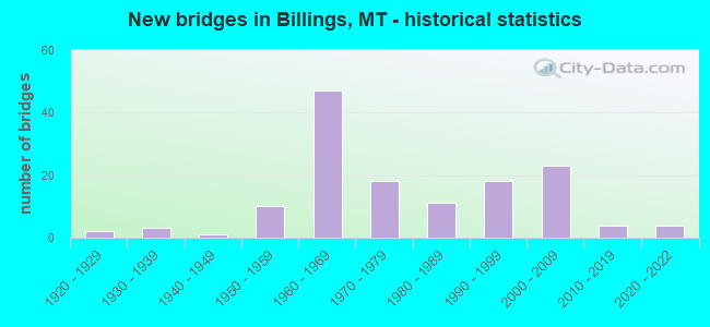
- New bridges - historical statistics
- 21920-1929
- 31930-1939
- 11940-1949
- 101950-1959
- 471960-1969
- 181970-1979
- 111980-1989
- 181990-1999
- 232000-2009
- 42010-2019
- 42020-2022

- Reconstructed bridges - Historical Statistics
- 11950-1959
- 31960-1969
- 11970-1979
- 31980-1989
- 31990-1999
- 22000-2009


- Bridge Condition - Deck
- 1.9%Very good
- 36.4%Good
- 54.2%Satisfactory
- 6.5%Fair
- 0.9%Poor

- Bridge Condition - Superstructure
- 1.9%Very good
- 58.9%Good
- 34.6%Satisfactory
- 2.8%Fair
- 1.9%Poor

- Bridge Condition - Substructure
- 1.9%Very good
- 39.3%Good
- 47.7%Satisfactory
- 8.4%Fair
- 2.8%Poor

- Bridge Condition - Channel
- 22.6%Very good
- 45.2%Good
- 27.4%Satisfactory
- 2.4%Fair
- 2.4%Poor

- Bridge Condition - Culverts
- 11.1%Very good
- 33.3%Good
- 44.4%Satisfactory
- 11.1%Fair
Find on map >> Show street view
Structure Number: I00090446+01582, Location: BILLINGS (Lat: 45.749739, Lng: -108.556453), Route carried "under" structure: City street 111, Year Built: 1994, Structure Length: 0. m, Average Daily Traffic: 22,452 (year 2020), Features Intersected: INT W BILLINGS-U 1010, Facility Carried by Structure: I 90
Minimum Vertical Clearance: 4.70m (15.42ft), Kilometerpoint: 4.991, Lanes on structure: 2, Lanes under structure: 4, Material/Design: Prestressed concrete, Design/Construction: Stringer/Multi-beam, Length of Maximum Span: 42.7m (140.1ft)
Find on map >> Show street view
Structure Number: I00090455+03081, Location: 25M E BILLINGS (Lat: 45.814875, Lng: -108.413986), Route carried "under" structure: ServiceCity street 1032, Year Built: 1967, Structure Length: 0. m, Average Daily Traffic: 8,753 (year 2020), Truck Traffic: 14%, Features Intersected: INT JOHNSON LANE, Facility Carried by Structure: I 90
Minimum Vertical Clearance: 4.67m (15.32ft), Kilometerpoint: 0.003, Lanes on structure: 2, Lanes under structure: 2, Material/Design: Prestressed concrete, Design/Construction: Stringer/Multi-beam, Length of Maximum Span: 17.4m (57.1ft)
Find on map >> Show street view
Structure Number: I00090455+03082, Location: 25M E BILLINGS (Lat: 45.815181, Lng: -108.413989), Route carried "under" structure: ServiceCity street 1032, Year Built: 1967, Structure Length: 0. m, Average Daily Traffic: 8,753 (year 2020), Truck Traffic: 14%, Features Intersected: INT JOHNSON LANE, Facility Carried by Structure: I 90
Minimum Vertical Clearance: 4.52m (14.83ft), Kilometerpoint: 0.000, Lanes on structure: 2, Lanes under structure: 2, Material/Design: Prestressed concrete, Design/Construction: Stringer/Multi-beam, Length of Maximum Span: 17.4m (57.1ft)
Find on map >> Show street view
Structure Number: I00090456+05801, Location: 37M E BILLINGS (Lat: 45.827383, Lng: -108.394583), Route carried "under" structure: Interstate 94, Year Built: 1967, Structure Length: 0. m, Average Daily Traffic: 9,062 (year 2020), Truck Traffic: 14%, Features Intersected: INT PINEHILL-I 94, Facility Carried by Structure: I 90
Minimum Vertical Clearance: 5.15m (16.90ft), Kilometerpoint: 0.437, Lanes on structure: 3, Lanes under structure: 4, Material/Design: Prestressed concrete, Design/Construction: Stringer/Multi-beam, Length of Maximum Span: 25.3m (83.0ft)
Find on map >> Show street view
Structure Number: I00090457+00541, Location: 43M E BILLINGS (Lat: 45.824511, Lng: -108.387153), Route carried "under" structure: ServiceState highway 56276, Year Built: 1969, Structure Length: 0. m, Average Daily Traffic: 100 (year 2022), Truck Traffic: 3%, Features Intersected: OLD HARDIN RD, Facility Carried by Structure: I 90
Minimum Vertical Clearance: 4.57m (14.99ft), Kilometerpoint: 0.156, Lanes on structure: 2, Lanes under structure: 2, Material/Design: Prestressed concrete, Design/Construction: Stringer/Multi-beam, Length of Maximum Span: 17.4m (57.1ft)
Find on map >> Show street view
Structure Number: I00090457+00542, Location: 43M E BILLINGS (Lat: 45.824642, Lng: -108.386781), Route carried "under" structure: ServiceState highway 56276, Year Built: 1969, Structure Length: 0. m, Average Daily Traffic: 100 (year 2022), Truck Traffic: 3%, Features Intersected: OLD HARDIN RD, Facility Carried by Structure: I 90
Minimum Vertical Clearance: 5.43m (17.81ft), Kilometerpoint: 0.188, Lanes on structure: 2, Lanes under structure: 2, Material/Design: Prestressed concrete, Design/Construction: Stringer/Multi-beam, Length of Maximum Span: 17.4m (57.1ft)
Find on map >> Show street view
Structure Number: I00094001+01781, Location: 37M E BILLINGS (Lat: 45.836731, Lng: -108.383578), Route carried "under" structure: County highway 56252, Year Built: 1967, Structure Length: 0. m, Average Daily Traffic: 100 (year 2022), Truck Traffic: 3%, Features Intersected: DICKIE ROAD, Facility Carried by Structure: I 94
Minimum Vertical Clearance: 4.95m (16.24ft), Kilometerpoint: 4.279, Lanes on structure: 2, Material/Design: Prestressed concrete, Design/Construction: Stringer/Multi-beam, Length of Maximum Span: 18.9m (62.0ft)
Find on map >> Show street view
Structure Number: I00094001+01782, Location: 37M E BILLINGS (Lat: 45.836978, Lng: -108.383714), Route carried "under" structure: County highway 56252, Year Built: 1967, Structure Length: 0. m, Average Daily Traffic: 100 (year 2022), Truck Traffic: 3%, Features Intersected: DICKIE ROAD, Facility Carried by Structure: I 94
Minimum Vertical Clearance: 6.04m (19.82ft), Kilometerpoint: 4.250, Lanes on structure: 2, Material/Design: Prestressed concrete, Design/Construction: Stringer/Multi-beam, Length of Maximum Span: 18.9m (62.0ft)
Find on map >> Show street view
Structure Number: L56200000+08001, Location: BILLINGS-ZOO DR (Lat: 45.732222, Lng: -108.603889), Route carried "under" structure: Interstate 90, Year Built: 2001, Structure Length: 0. m, Average Daily Traffic: 27,263 (year 2020), Truck Traffic: 9%, Features Intersected: SHILOH INTERCHANGE 014, Facility Carried by Structure: ZOO DR
Minimum Vertical Clearance: 7.04m (23.10ft), Kilometerpoint: 710.298, Lanes on structure: 2, Lanes under structure: 4, Material/Design: Prestressed concrete, Design/Construction: Stringer/Multi-beam, Length of Maximum Span: 32.9m (107.9ft)
Find on map >> Show street view
Structure Number: L56395002+04001, Location: BILLINGS (Lat: 45.757442, Lng: -108.494294), Route carried "under" structure: Interstate 90, Year Built: 1966, Structure Length: 0. m, Average Daily Traffic: 29,001 (year 2020), Truck Traffic: 12%, Features Intersected: SEP I 90 011, Facility Carried by Structure: SUGAR AVE
Minimum Vertical Clearance: 5.79m (19.00ft), Kilometerpoint: 719.637, Lanes on structure: 2, Lanes under structure: 4, Material/Design: Prestressed concrete, Design/Construction: Stringer/Multi-beam, Length of Maximum Span: 21.9m (71.9ft)
Find on map >> Show street view
Structure Number: P00016000+00001, Location: BILLINGS (Lat: 45.796397, Lng: -108.456953), Route carried "under" structure: Interstate 90, Year Built: 1966, Structure Length: 0. m, Average Daily Traffic: 27,179 (year 2020), Truck Traffic: 12%, Features Intersected: INT LOCKWOOD I 90, Facility Carried by Structure: US 87
Minimum Vertical Clearance: 5.00m (16.40ft), Kilometerpoint: 725.361, Lanes on structure: 4, Lanes under structure: 4, Material/Design: Prestressed concrete, Design/Construction: Stringer/Multi-beam, Length of Maximum Span: 21.9m (71.9ft)
Find on map >> Show street view
Structure Number: P00053000+00001, Location: BILLINGS-S 27TH ST (Lat: 45.767661, Lng: -108.487264), Route carried "under" structure: Interstate 90, Year Built: 1966, Structure Length: 0. m, Average Daily Traffic: 29,001 (year 2020), Truck Traffic: 12%, Features Intersected: INT 27TH ST I 90, Facility Carried by Structure: S 27TH ST
Minimum Vertical Clearance: 5.23m (17.16ft), Kilometerpoint: 720.935, Lanes on structure: 4, Lanes under structure: 4, Material/Design: Prestressed concrete, Design/Construction: Stringer/Multi-beam, Length of Maximum Span: 20.4m (66.9ft)
Find on map >> Show street view
Structure Number: S00429002+02661, Location: 2M SW BILLINGS (Lat: 45.725678, Lng: -108.617519), Route carried "under" structure: Interstate 90, Year Built: 1959, Structure Length: 0. m, Average Daily Traffic: 26,045 (year 2020), Truck Traffic: 10%, Features Intersected: SEP I 90, Facility Carried by Structure: S SHILOH RD
Minimum Vertical Clearance: 6.70m (21.98ft), Kilometerpoint: 709.017, Lanes on structure: 2, Lanes under structure: 4, Material/Design: Prestressed concrete, Design/Construction: Stringer/Multi-beam, Length of Maximum Span: 18.9m (62.0ft)
Find on map >> Show street view
Structure Number: U01010002+09211, Location: BILLINGS-MULLOWNEY LN (Lat: 45.751353, Lng: -108.558883), Route carried "under" structure: Business City street 113, Year Built: 2007, Structure Length: 0. m, Average Daily Traffic: 18,739 (year 2020), Features Intersected: LAUREL ROAD, Facility Carried by Structure: MULLOWNEY LN
Minimum Vertical Clearance: 4.65m (15.26ft), Kilometerpoint: 0.270, Lanes on structure: 2, Lanes under structure: 4, Material/Design: Prestressed concrete, Design/Construction: Stringer/Multi-beam, Length of Maximum Span: 26.0m (85.3ft)
Find on map >> Show street view
Structure Number: U01013000+07771, Location: BILLINGS-S BILLINGS BLVD (Lat: 45.752242, Lng: -108.535653), Route carried "under" structure: Interstate 90, Year Built: 1963, Structure Length: 0. m, Average Daily Traffic: 29,001 (year 2020), Truck Traffic: 12%, Features Intersected: SEP BILLINGS BLVD-I 90, Facility Carried by Structure: S BILLINGS BLVD
Minimum Vertical Clearance: 5.10m (16.73ft), Kilometerpoint: 716.260, Lanes on structure: 2, Lanes under structure: 4, Material/Design: Prestressed concrete, Design/Construction: Stringer/Multi-beam, Length of Maximum Span: 18.7m (61.4ft)
Find on map >> Show street view
Structure Number: U01014002+05171, Location: BILLINGS-E AIRPORT RD (Lat: 45.803358, Lng: -108.483606), Route carried "under" structure: ServiceCity street 56000, Year Built: 2009, Structure Length: 0. m, Average Daily Traffic: 100 (year 2022), Truck Traffic: 3%, Features Intersected: 6TH AVE N BYPASS 21, Facility Carried by Structure: E AIRPORT RD
Minimum Vertical Clearance: 5.08m (16.67ft), Kilometerpoint: 0.193, Lanes on structure: 6, Lanes under structure: 3, Material/Design: Prestressed concrete, Design/Construction: Stringer/Multi-beam, Length of Maximum Span: 25.0m (82.0ft)
Find on map >> Show street view
Structure Number: U01020001+08851, Location: BILLINGS-MONTANA AVE (Lat: 45.767522, Lng: -108.532450), Route carried "under" structure: City street 1025, Year Built: 1960, Structure Length: 0. m, Average Daily Traffic: 13,193 (year 2020), Features Intersected: U1025-RR, Facility Carried by Structure: MONTANA AVE
Minimum Vertical Clearance: 5.18m (16.99ft), Kilometerpoint: 0.688, Lanes on structure: 2, Lanes under structure: 4, Material/Design: Steel, Design/Construction: Stringer/Multi-beam, Length of Maximum Span: 23.5m (77.1ft)
Find on map >> Show street view
Structure Number: U01020001+08852, Location: BILLINGS-MONTANA AVE (Lat: 45.767350, Lng: -108.532964), Route carried "under" structure: City street 1025, Year Built: 1960, Structure Length: 0. m, Average Daily Traffic: 13,193 (year 2020), Features Intersected: U1024-25-RR, Facility Carried by Structure: MONTANA AVE
Minimum Vertical Clearance: 4.62m (15.16ft), Kilometerpoint: 0.676, Lanes on structure: 2, Lanes under structure: 4, Material/Design: Steel, Design/Construction: Stringer/Multi-beam, Length of Maximum Span: 23.5m (77.1ft)
Find on map >> Show street view
Structure Number: U01027002+01201, Location: BILLINGS-HILLTOP RD (Lat: 45.812883, Lng: -108.476228), Route carried "under" structure: ServiceState highway 56000, Year Built: 1990, Structure Length: 0. m, Average Daily Traffic: 10,509 (year 2020), Truck Traffic: 3%, Features Intersected: LAKE ELMO DR, Facility Carried by Structure: HILLTOP RD
Minimum Vertical Clearance: 4.70m (15.42ft), Kilometerpoint: 0.812, Lanes on structure: 4, Lanes under structure: 2, Material/Design: Prestressed concrete, Design/Construction: Stringer/Multi-beam, Length of Maximum Span: 20.5m (67.3ft)
Find on map >> Show street view
Structure Number: U01035000+05001, Location: BILLINGS (Lat: 45.768578, Lng: -108.530436), Route carried "under" structure: Business City street 1025, Year Built: 1977, Structure Length: 0. m, Average Daily Traffic: 18,175 (year 2020), Features Intersected: UNDERPASS AVENUE, Facility Carried by Structure: CENTRAL AVE RAMP
Minimum Vertical Clearance: 4.60m (15.09ft), Kilometerpoint: 1.049, Lanes on structure: 1, Lanes under structure: 2, Material/Design: Prestressed concrete, Design/Construction: Stringer/Multi-beam, Length of Maximum Span: 15.4m (50.5ft)