Bridge Statistics for Broomfield, Colorado (CO)
Condition, Traffic, Stress, Structural Evaluation, Project Costs
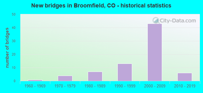
- New bridges - historical statistics
- 11960-1969
- 41970-1979
- 71980-1989
- 131990-1999
- 432000-2009
- 62010-2019
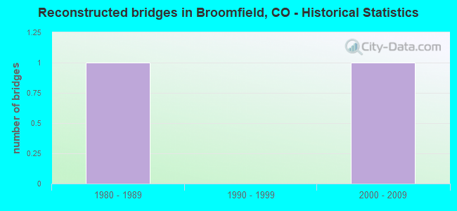
- Reconstructed bridges - Historical Statistics
- 11980-1989
- 01990-1999
- 12000-2009

- Bridge Condition - Deck
- 8.8%Very good
- 73.5%Good
- 11.8%Satisfactory
- 2.9%Fair
- 2.9%Poor
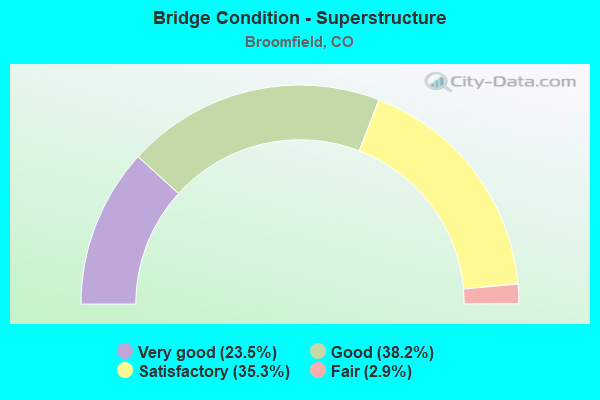
- Bridge Condition - Superstructure
- 23.5%Very good
- 38.2%Good
- 35.3%Satisfactory
- 2.9%Fair
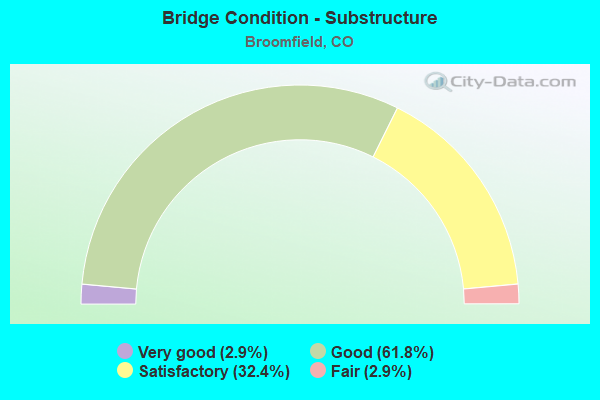
- Bridge Condition - Substructure
- 2.9%Very good
- 61.8%Good
- 32.4%Satisfactory
- 2.9%Fair
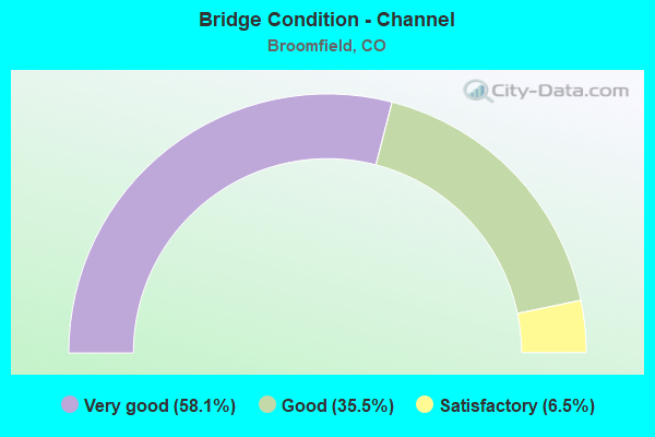
- Bridge Condition - Channel
- 58.1%Very good
- 35.5%Good
- 6.5%Satisfactory
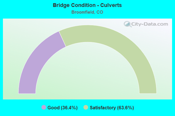
- Bridge Condition - Culverts
- 36.4%Good
- 63.6%Satisfactory
Find on map >> Show street view
Structure Number: 46.28, Location: I25 NB ramp to NWP WB (Lat: 39.982222, Lng: -104.989444), Route carried "on" structure: Ramp Other road 470N, Year Built: 2003, Status: Open, Structure Length: 24.56m (80.58ft), Average Daily Traffic: 820 (year 2018), Truck Traffic: 10%, Average Future Daily Traffic: 10,000 (year 2029), Design Load: HS 25 or greater, Features Intersected: I-25 and NWP, Facility Carried by Structure: Ramp B
Minimum Vertical Clearance: 5.28m (17.32ft), Kilometerpoint: 0.661, Lanes on structure: 1, Lanes under structure: 10, Base Highway Network: Yes, Toll: On toll road, Owner: Local Toll Authority, Approaching Roadway Width: 8.2m (26.9ft), Skew: 9 degrees, Material/Design: Steel continuous, Design/Construction: Stringer/Multi-beam, Number Of Spans In Main Unit: 4, Length of Maximum Span: 67.3m (220.8ft), Curb-To-Curb Width: 8.2m (26.9ft), Out-to-Out Width: 9.1m (29.9ft)
Condition: Deck: Good, Superstructure: Good, Substructure: Good, Operating Rating: 71.8 metric tons, Method Used To Determine Operating Rating: Load Factor (LF), Inventory Rating: 43.0 metric tons, Method Used To Determine Inventory Rating: Load Factor (LF), Structural Evaluation: Better than present minimum criteria, Deck Geometry: Superior to present desirable criteria, Underclear: Superior to present desirable criteria, Approach Roadway Alignment: Equal to present minimum criteria, Designated Inspection Frequency: Every 24 months, Inspection Date: June 2021, Deck Structure Type: Concrete Cast-file-Place, Wearing Surface/Protective System: Wearing Surface: Bituminous, Membrane: Preformed Fabric, Deck Protection: Epoxy Coated Reinforcing
Find on map >> Show street view
Structure Number: 46.43, Location: EB NWP ramp to NB I25 (Lat: 39.981389, Lng: -104.990833), Route carried "on" structure: Ramp Other road 470N, Year Built: 2003, Status: Open, Structure Length: 41.44m (135.96ft), Average Daily Traffic: 1,500 (year 2018), Truck Traffic: 10%, Average Future Daily Traffic: 10,000 (year 2029), Design Load: HS 25 or greater, Features Intersected: I-25 and NWP, Facility Carried by Structure: Ramp H
Minimum Vertical Clearance: 30.45m (99.90ft), Kilometerpoint: 0.222, Lanes on structure: 1, Lanes under structure: 12, Base Highway Network: Yes, Toll: On toll road, Owner: Local Toll Authority, Approaching Roadway Width: 7.5m (24.6ft), Skew: 9 degrees, Material/Design: Steel continuous, Design/Construction: Stringer/Multi-beam, Number Of Spans In Main Unit: 8, Length of Maximum Span: 52.2m (171.3ft), Curb-To-Curb Width: 8.2m (26.9ft), Out-to-Out Width: 9.2m (30.2ft)
Condition: Deck: Satisfactory, Superstructure: Good, Substructure: Good, Operating Rating: 71.8 metric tons, Method Used To Determine Operating Rating: Load Factor (LF), Inventory Rating: 43.0 metric tons, Method Used To Determine Inventory Rating: Load Factor (LF), Structural Evaluation: Better than present minimum criteria, Deck Geometry: Superior to present desirable criteria, Underclear: Superior to present desirable criteria, Approach Roadway Alignment: Equal to present minimum criteria, Designated Inspection Frequency: Every 24 months, Inspection Date: June 2021, Deck Structure Type: Concrete Cast-file-Place, Wearing Surface/Protective System: Wearing Surface: Bituminous, Membrane: Preformed Fabric, Deck Protection: Epoxy Coated Reinforcing
Find on map >> Show street view
Structure Number: BC-68-4.7-RO, Location: 0.3 Mi W of Hwy 287 (Lat: 39.957864, Lng: -105.085369), Route carried "on" structure: County highway , Year Built: 2019, Status: Open, Structure Length: 1.16m (3.81ft), Average Daily Traffic: 922 (year 2020), Truck Traffic: 19%, Average Future Daily Traffic: 1,106 (year 2040), Design Load: HL 93, Features Intersected: Rock Creek, Facility Carried by Structure: Dillon Road
Minimum Vertical Clearance: 30+ m (98+ ft), Kilometerpoint: 0.208, Lanes on structure: 2, Owner: County Highway Agency, Approaching Roadway Width: 7.9m (25.9ft), Material/Design: Concrete, Design/Construction: Culvert, Number Of Spans In Main Unit: 3, Length of Maximum Span: 3.7m (12.1ft), Curb-To-Curb Width: 10.1m (33.1ft), Out-to-Out Width: 10.8m (35.4ft)
Condition: Channel: Very good, Culverts: Good, Operating Rating: 32.7 metric tons, Method Used To Determine Operating Rating: No rating analysis performed, Inventory Rating: 32.7 metric tons, Method Used To Determine Inventory Rating: No rating analysis performed, Structural Evaluation: Better than present minimum criteria, Deck Geometry: Equal to present minimum criteria, Waterway Adequacy: Equal to present desirable criteria, Approach Roadway Alignment: Equal to present desirable criteria, Designated Inspection Frequency: Every 24 months, Inspection Date: July 2021
Find on map >> Show street view
Structure Number: BFD-123RD-WOLFF, Location: North of Wolff Drive (Lat: 39.920494, Lng: -105.051128), Route carried "on" structure: City street , Year Built: 1996, Status: Open, Structure Length: 1.05m (3.44ft), Average Daily Traffic: 2,150 (year 2020), Truck Traffic: 8%, Average Future Daily Traffic: 2,709 (year 2040), Design Load: HS 20, Features Intersected: Local Drainage, Facility Carried by Structure: 123rd Place
Minimum Vertical Clearance: 30+ m (98+ ft), Kilometerpoint: 0.259, Lanes on structure: 2, Owner: City or Municipal Highway Agency, Approaching Roadway Width: 11.6m (38.1ft), Material/Design: Concrete, Design/Construction: Culvert, Number Of Spans In Main Unit: 4, Length of Maximum Span: 2.4m (7.9ft), Curb or Sidewalk Widths: Left: 2.3m (7.5ft), Right: 2.3m (7.5ft), Curb-To-Curb Width: 11.6m (38.1ft), Out-to-Out Width: 16.8m (55.1ft)
Condition: Channel: Satisfactory, Culverts: Good, Operating Rating: 67.8 metric tons, Method Used To Determine Operating Rating: Load Factor (LF), Inventory Rating: 40.6 metric tons, Method Used To Determine Inventory Rating: Load Factor (LF), Structural Evaluation: Better than present minimum criteria, Deck Geometry: Somewhat better than minimum adequacy, Waterway Adequacy: Equal to present desirable criteria, Approach Roadway Alignment: Equal to present desirable criteria, Designated Inspection Frequency: Every 24 months, Inspection Date: January 2021
Find on map >> Show street view
Structure Number: BFD-BRIARWD-TRL, Location: Just South of Trails Ave (Lat: 39.938900, Lng: -105.032986), Route carried "on" structure: City street , Year Built: 1987, Status: Open, Structure Length: 0.65m (2.13ft), Average Daily Traffic: 361 (year 2020), Truck Traffic: 12%, Average Future Daily Traffic: 455 (year 2040), Design Load: HS 20, Features Intersected: Local Drainage, Facility Carried by Structure: Briarwood Drive
Minimum Vertical Clearance: 30+ m (98+ ft), Kilometerpoint: 0.019, Lanes on structure: 2, Owner: City or Municipal Highway Agency, Approaching Roadway Width: 11.0m (36.1ft), Material/Design: Concrete, Design/Construction: Culvert, Number Of Spans In Main Unit: 4, Length of Maximum Span: 1.2m (3.9ft), Curb or Sidewalk Widths: Left: 1.4m (4.6ft), Right: 1.5m (4.9ft), Curb-To-Curb Width: 11.0m (36.1ft), Out-to-Out Width: 17.3m (56.8ft)
Condition: Channel: Very good, Culverts: Satisfactory, Operating Rating: 36.3 metric tons, Method Used To Determine Operating Rating: Field evaluation and documented engineering judgment, Inventory Rating: 32.7 metric tons, Method Used To Determine Inventory Rating: Field evaluation and documented engineering judgment, Structural Evaluation: Equal to present minimum criteria, Deck Geometry: Equal to present desirable criteria, Waterway Adequacy: Equal to present desirable criteria, Approach Roadway Alignment: Equal to present desirable criteria, Designated Inspection Frequency: Every 24 months, Inspection Date: January 2021
Find on map >> Show street view
Structure Number: BFD-BRLND-LONG, Location: 0.3 Mi N of 136th Ave (Lat: 39.947967, Lng: -105.046061), Route carried "on" structure: City street , Year Built: 1997, Status: Open, Structure Length: 0.77m (2.53ft), Average Daily Traffic: 1,886 (year 2020), Truck Traffic: 3%, Average Future Daily Traffic: 2,376 (year 2040), Design Load: HL 93, Features Intersected: Local Drainage, Facility Carried by Structure: Broadlands Drive
Minimum Vertical Clearance: 30+ m (98+ ft), Kilometerpoint: 0.542, Lanes on structure: 2, Owner: City or Municipal Highway Agency, Approaching Roadway Width: 8.6m (28.2ft), Skew: 3 degrees, Material/Design: Concrete, Design/Construction: Culvert, Number Of Spans In Main Unit: 2, Length of Maximum Span: 3.7m (12.1ft), Curb or Sidewalk Widths: Left: 1.4m (4.6ft), Right: 2.6m (8.5ft), Curb-To-Curb Width: 8.6m (28.2ft), Out-to-Out Width: 18.2m (59.7ft)
Condition: Channel: Good, Culverts: Good, Operating Rating: 62.1 metric tons, Method Used To Determine Operating Rating: Load Factor (LF), Inventory Rating: 37.1 metric tons, Method Used To Determine Inventory Rating: Load Factor (LF), Structural Evaluation: Better than present minimum criteria, Deck Geometry: Somewhat better than minimum adequacy, Waterway Adequacy: Equal to present desirable criteria, Approach Roadway Alignment: Better than present minimum criteria, Designated Inspection Frequency: Every 24 months, Inspection Date: January 2021
Find on map >> Show street view
Structure Number: BFD-CHASE-120TH, Location: At 120th Avenue (Lat: 39.914047, Lng: -105.058117), Route carried "on" structure: City street , Year Built: 2000, Status: Open, Structure Length: 0.76m (2.49ft), Average Daily Traffic: 3,767 (year 2020), Truck Traffic: 9%, Average Future Daily Traffic: 4,746 (year 2040), Features Intersected: Local Drainage, Facility Carried by Structure: Chase Street
Minimum Vertical Clearance: 30+ m (98+ ft), Kilometerpoint: 22.141, Lanes on structure: 3, Owner: City or Municipal Highway Agency, Approaching Roadway Width: 12.2m (40.0ft), Material/Design: Concrete, Design/Construction: Culvert, Number Of Spans In Main Unit: 2, Length of Maximum Span: 3.7m (12.1ft), Curb or Sidewalk Widths: Left: 3.0m (9.8ft), Right: 3.0m (9.8ft), Curb-To-Curb Width: 12.2m (40.0ft), Out-to-Out Width: 18.9m (62.0ft)
Condition: Channel: Good, Culverts: Satisfactory, Operating Rating: 65.9 metric tons, Method Used To Determine Operating Rating: Load Factor (LF), Inventory Rating: 39.5 metric tons, Method Used To Determine Inventory Rating: Load Factor (LF), Structural Evaluation: Equal to present minimum criteria, Deck Geometry: Meets minimum limits, Waterway Adequacy: Better than present minimum criteria, Approach Roadway Alignment: Equal to present desirable criteria, Designated Inspection Frequency: Every 24 months, Inspection Date: January 2021
Find on map >> Show street view
Structure Number: BFD-E.1ST-KIRK, Location: 150 Ft E of Kirk Street (Lat: 39.915050, Lng: -105.060231), Route carried "on" structure: City street , Year Built: 1999, Status: Open, Structure Length: 1.24m (4.07ft), Average Daily Traffic: 8,366 (year 2020), Truck Traffic: 8%, Average Future Daily Traffic: 10,541 (year 2040), Design Load: HS 20, Features Intersected: Local Drainage, Facility Carried by Structure: East 1st Street
Minimum Vertical Clearance: 30+ m (98+ ft), Kilometerpoint: 1.556, Lanes on structure: 3, Owner: City or Municipal Highway Agency, Approaching Roadway Width: 11.0m (36.1ft), Skew: 4 degrees, Material/Design: Concrete, Design/Construction: Culvert, Number Of Spans In Main Unit: 2, Length of Maximum Span: 6.0m (19.7ft), Curb or Sidewalk Widths: Left: 1.5m (4.9ft), Right: 1.7m (5.6ft), Curb-To-Curb Width: 11.0m (36.1ft), Out-to-Out Width: 18.6m (61.0ft)
Condition: Channel: Very good, Culverts: Satisfactory, Operating Rating: 98.4 metric tons, Method Used To Determine Operating Rating: Load Factor (LF), Inventory Rating: 59.1 metric tons, Method Used To Determine Inventory Rating: Load Factor (LF), Structural Evaluation: Equal to present minimum criteria, Deck Geometry: High priority of replacement, Waterway Adequacy: Equal to present desirable criteria, Approach Roadway Alignment: Equal to present desirable criteria, Length Of Structure Improvement: 0.24m (0.79ft), Designated Inspection Frequency: Every 24 months, Inspection Date: January 2021, Bridge Improvement Cost: $162,000, Roadway Improvement Cost: $16,000, Total Project Cost: $178,000 ( Estimate for 2019)
Find on map >> Show street view
Structure Number: BFD-HAZEL-128, Location: Just S of Midway Blvd (Lat: 39.928292, Lng: -105.028269), Route carried "on" structure: City street , Year Built: 1985, Status: Open, Structure Length: 1.28m (4.20ft), Average Daily Traffic: 1,946 (year 2020), Truck Traffic: 8%, Average Future Daily Traffic: 2,452 (year 2040), Design Load: HS 20, Features Intersected: Local Drainage, Facility Carried by Structure: Hazel Street
Minimum Vertical Clearance: 30+ m (98+ ft), Kilometerpoint: 0.402, Lanes on structure: 2, Owner: City or Municipal Highway Agency, Approaching Roadway Width: 11.6m (38.1ft), Material/Design: Concrete, Design/Construction: Culvert, Number Of Spans In Main Unit: 4, Length of Maximum Span: 3.0m (9.8ft), Curb or Sidewalk Widths: Left: 1.4m (4.6ft), Right: 1.4m (4.6ft), Curb-To-Curb Width: 11.6m (38.1ft), Out-to-Out Width: 14.9m (48.9ft)
Condition: Channel: Good, Culverts: Satisfactory, Operating Rating: 45.1 metric tons, Method Used To Determine Operating Rating: Load Factor (LF), Inventory Rating: 27.0 metric tons, Method Used To Determine Inventory Rating: Load Factor (LF), Structural Evaluation: Equal to present minimum criteria, Deck Geometry: Equal to present minimum criteria, Waterway Adequacy: Equal to present desirable criteria, Approach Roadway Alignment: Equal to present desirable criteria, Designated Inspection Frequency: Every 24 months, Inspection Date: January 2021
Find on map >> Show street view
Structure Number: BFD-INTB-W.FLAT, Location: 100 Ft SE of W Flatiron (Lat: 39.929411, Lng: -105.130550), Route carried "on" structure: County highway , Year Built: 1999, Status: Open, Structure Length: 0.79m (2.59ft), Average Daily Traffic: 6,608 (year 2021), Truck Traffic: 5%, Average Future Daily Traffic: 8,326 (year 2041), Design Load: HS 20, Features Intersected: Ped. Underpass/Drainage, Facility Carried by Structure: Interlocken Blvd.
Minimum Vertical Clearance: 30+ m (98+ ft), Kilometerpoint: 3.160, Lanes on structure: 8, Owner: City or Municipal Highway Agency, Approaching Roadway Width: 31.2m (102.4ft), Skew: 30 degrees, Material/Design: Concrete, Design/Construction: Culvert, Number Of Spans In Main Unit: 1, Length of Maximum Span: 7.9m (25.9ft), Curb or Sidewalk Widths: Left: 2.5m (8.2ft), Right: 2.5m (8.2ft), Curb-To-Curb Width: 31.2m (102.4ft), Out-to-Out Width: 39.8m (130.6ft)
Condition: Channel: Very good, Culverts: Satisfactory, Inventory Rating: 73.7 metric tons, Method Used To Determine Inventory Rating: Load Factor (LF), Structural Evaluation: Equal to present minimum criteria, Deck Geometry: Somewhat better than minimum adequacy, Waterway Adequacy: Equal to present desirable criteria, Approach Roadway Alignment: Better than present minimum criteria, Designated Inspection Frequency: Every 24 months, Inspection Date: January 2021
Find on map >> Show street view
Structure Number: BFD-INTL-ELDOR, Location: 125 Ft. N of Eldorado (Lat: 39.922836, Lng: -105.128772), Route carried "on" structure: County highway , Year Built: 1999, Status: Open, Structure Length: 0.73m (2.40ft), Average Daily Traffic: 14,768 (year 2021), Truck Traffic: 7%, Average Future Daily Traffic: 18,608 (year 2041), Design Load: HS 20, Features Intersected: Pedestrian Underpass, Facility Carried by Structure: Interlocken Loop
Minimum Vertical Clearance: 30+ m (98+ ft), Kilometerpoint: 0.684, Lanes on structure: 6, Owner: City or Municipal Highway Agency, Approaching Roadway Width: 29.4m (96.5ft), Skew: 30 degrees, Material/Design: Concrete, Design/Construction: Culvert, Number Of Spans In Main Unit: 1, Length of Maximum Span: 7.3m (24.0ft), Curb or Sidewalk Widths: Left: 2.4m (7.9ft), Right: 2.5m (8.2ft), Curb-To-Curb Width: 29.4m (96.5ft), Out-to-Out Width: 38.4m (126.0ft)
Condition: Culverts: Satisfactory, Structural Evaluation: Equal to present minimum criteria, Deck Geometry: Superior to present desirable criteria, Approach Roadway Alignment: Equal to present desirable criteria, Designated Inspection Frequency: Every 24 months, Inspection Date: January 2021
Find on map >> Show street view
Structure Number: BFD-INTL-INTB, Location: Just N of Interlocken Blv (Lat: 39.929717, Lng: -105.127642), Route carried "on" structure: County highway , Year Built: 2000, Status: Open, Structure Length: 0.79m (2.59ft), Average Daily Traffic: 12,973 (year 2021), Truck Traffic: 5%, Average Future Daily Traffic: 16,346 (year 2041), Design Load: HS 20, Features Intersected: Ped. Underpass/Drainage, Facility Carried by Structure: Interlocken Loop
Minimum Vertical Clearance: 30+ m (98+ ft), Kilometerpoint: 1.475, Lanes on structure: 7, Owner: City or Municipal Highway Agency, Approaching Roadway Width: 27.5m (90.2ft), Skew: 30 degrees, Material/Design: Concrete, Design/Construction: Culvert, Number Of Spans In Main Unit: 1, Length of Maximum Span: 7.9m (25.9ft), Curb or Sidewalk Widths: Left: 2.5m (8.2ft), Right: 2.4m (7.9ft), Curb-To-Curb Width: 27.5m (90.2ft), Out-to-Out Width: 38.6m (126.6ft)
Condition: Channel: Very good, Culverts: Satisfactory, Inventory Rating: 67.8 metric tons, Method Used To Determine Inventory Rating: Load Factor (LF), Structural Evaluation: Equal to present minimum criteria, Deck Geometry: Somewhat better than minimum adequacy, Waterway Adequacy: Equal to present desirable criteria, Approach Roadway Alignment: Equal to present desirable criteria, Designated Inspection Frequency: Every 24 months, Inspection Date: January 2021
Find on map >> Show street view
Structure Number: BFD-INTL-W.FLAT, Location: 0.1 Mi N of W. Flatiron C (Lat: 39.932986, Lng: -105.127781), Route carried "on" structure: County highway , Year Built: 2000, Status: Open, Structure Length: 0.79m (2.59ft), Average Daily Traffic: 21,192 (year 2021), Truck Traffic: 5%, Average Future Daily Traffic: 26,702 (year 2041), Design Load: HS 20, Features Intersected: Pedestrian Underpass, Facility Carried by Structure: Interlocken Loop
Minimum Vertical Clearance: 30+ m (98+ ft), Kilometerpoint: 1.885, Lanes on structure: 7, Owner: City or Municipal Highway Agency, Approaching Roadway Width: 31.5m (103.3ft), Skew: 30 degrees, Material/Design: Concrete, Design/Construction: Culvert, Number Of Spans In Main Unit: 1, Length of Maximum Span: 7.9m (25.9ft), Curb or Sidewalk Widths: Left: 2.5m (8.2ft), Right: 2.5m (8.2ft), Curb-To-Curb Width: 31.5m (103.3ft), Out-to-Out Width: 46.3m (151.9ft)
Condition: Channel: Very good, Culverts: Satisfactory, Structural Evaluation: Equal to present minimum criteria, Deck Geometry: Superior to present desirable criteria, Waterway Adequacy: Equal to present desirable criteria, Approach Roadway Alignment: Equal to present desirable criteria, Designated Inspection Frequency: Every 24 months, Inspection Date: January 2021
Find on map >> Show street view
Structure Number: BFD-INTLE-W.FLT, Location: 400 Ft N. of Interlocken (Lat: 39.930542, Lng: -105.127656), Route carried "on" structure: County highway , Year Built: 2000, Status: Open, Structure Length: 4.69m (15.39ft), Average Daily Traffic: 6,635 (year 2021), Truck Traffic: 6%, Average Future Daily Traffic: 8,360 (year 2041), Design Load: HS 20, Features Intersected: W. Flatiron Crossing Dr., Facility Carried by Structure: Interlocken Loop N
Minimum Vertical Clearance: 30+ m (98+ ft), Kilometerpoint: 1.579, Lanes on structure: 3, Lanes under structure: 7, Owner: City or Municipal Highway Agency, Approaching Roadway Width: 11.3m (37.1ft), Skew: 10 degrees, Material/Design: Prestressed concrete continuous, Design/Construction: Stringer/Multi-beam, Number Of Spans In Main Unit: 2, Length of Maximum Span: 21.9m (71.9ft), Curb or Sidewalk Widths: Left: 0.0m, Right: 2.4m (7.9ft), Curb-To-Curb Width: 11.3m (37.1ft), Out-to-Out Width: 14.8m (48.6ft)
Condition: Deck: Satisfactory, Superstructure: Very good, Substructure: Good, Operating Rating: 36.3 metric tons, Method Used To Determine Operating Rating: Field evaluation and documented engineering judgment, Inventory Rating: 32.7 metric tons, Method Used To Determine Inventory Rating: Field evaluation and documented engineering judgment, Structural Evaluation: Better than present minimum criteria, Deck Geometry: High priority of replacement, Underclear: Superior to present desirable criteria, Approach Roadway Alignment: Equal to present desirable criteria, Length Of Structure Improvement: 4.69m (15.39ft), Designated Inspection Frequency: Every 24 months, Inspection Date: January 2021, Bridge Improvement Cost: $796,000, Roadway Improvement Cost: $80,000, Total Project Cost: $875,000 ( Estimate for 2019), Deck Structure Type: Concrete Cast-file-Place, Wearing Surface/Protective System: Wearing Surface: Bituminous, Membrane: Preformed Fabric, Deck Protection: Epoxy Coated Reinforcing
Find on map >> Show street view
Structure Number: BFD-INTLW-W.FLT, Location: 400 Ft N. of Interlocken (Lat: 39.930531, Lng: -105.127925), Route carried "on" structure: County highway , Year Built: 2000, Status: Open, Structure Length: 4.69m (15.39ft), Average Daily Traffic: 6,347 (year 2021), Truck Traffic: 5%, Average Future Daily Traffic: 7,997 (year 2041), Design Load: HS 20, Features Intersected: W. Flatiron Crossing, Facility Carried by Structure: Interlocken Loop S
Minimum Vertical Clearance: 30+ m (98+ ft), Kilometerpoint: 1.577, Lanes on structure: 3, Lanes under structure: 7, Owner: City or Municipal Highway Agency, Approaching Roadway Width: 11.3m (37.1ft), Skew: 10 degrees, Material/Design: Prestressed concrete continuous, Design/Construction: Stringer/Multi-beam, Number Of Spans In Main Unit: 2, Length of Maximum Span: 21.9m (71.9ft), Curb or Sidewalk Widths: Left: 2.4m (7.9ft), Right: 0.0m, Curb-To-Curb Width: 11.3m (37.1ft), Out-to-Out Width: 14.8m (48.6ft)
Condition: Deck: Good, Superstructure: Very good, Substructure: Satisfactory, Operating Rating: 65.5 metric tons, Method Used To Determine Operating Rating: Load Factor (LF), Inventory Rating: 39.3 metric tons, Method Used To Determine Inventory Rating: Load Factor (LF), Structural Evaluation: Equal to present minimum criteria, Deck Geometry: High priority of replacement, Underclear: Equal to present minimum criteria, Approach Roadway Alignment: Equal to present desirable criteria, Length Of Structure Improvement: 4.69m (15.39ft), Designated Inspection Frequency: Every 24 months, Inspection Date: January 2021, Bridge Improvement Cost: $794,000, Roadway Improvement Cost: $79,000, Total Project Cost: $873,000 ( Estimate for 2019), Deck Structure Type: Concrete Cast-file-Place, Wearing Surface/Protective System: Wearing Surface: Bituminous, Membrane: Preformed Fabric, Deck Protection: Epoxy Coated Reinforcing
Find on map >> Show street view
Structure Number: BFD-KIRK-E.1ST, Location: 50 Ft N of E. 1st Street (Lat: 39.915297, Lng: -105.060281), Route carried "on" structure: City street , Year Built: 1999, Status: Open, Structure Length: 1.00m (3.28ft), Average Daily Traffic: 1,933 (year 2020), Truck Traffic: 6%, Average Future Daily Traffic: 2,436 (year 2040), Design Load: HS 20, Features Intersected: Local Drainage, Facility Carried by Structure: Kirk Street
Minimum Vertical Clearance: 30+ m (98+ ft), Kilometerpoint: 1.458, Lanes on structure: 2, Owner: City or Municipal Highway Agency, Approaching Roadway Width: 7.3m (24.0ft), Material/Design: Concrete, Design/Construction: Culvert, Number Of Spans In Main Unit: 2, Length of Maximum Span: 4.9m (16.1ft), Curb or Sidewalk Widths: Left: 2.1m (6.9ft), Right: 2.1m (6.9ft), Curb-To-Curb Width: 7.3m (24.0ft), Out-to-Out Width: 12.2m (40.0ft)
Condition: Channel: Very good, Culverts: Satisfactory, Inventory Rating: 68.4 metric tons, Method Used To Determine Inventory Rating: Load Factor (LF), Structural Evaluation: Equal to present minimum criteria, Deck Geometry: Meets minimum limits, Waterway Adequacy: Equal to present desirable criteria, Approach Roadway Alignment: Equal to present desirable criteria, Designated Inspection Frequency: Every 24 months, Inspection Date: January 2021
Find on map >> Show street view
Structure Number: BFD-LOWELL-136, Location: .2 Mi N of 136th Avenue (Lat: 39.945389, Lng: -105.034269), Route carried "on" structure: City street , Year Built: 1998, Status: Open, Structure Length: 0.78m (2.56ft), Average Daily Traffic: 13,631 (year 2020), Truck Traffic: 4%, Average Future Daily Traffic: 17,175 (year 2040), Design Load: HS 20, Features Intersected: Local Drainage, Facility Carried by Structure: Lowell Street
Minimum Vertical Clearance: 30+ m (98+ ft), Kilometerpoint: 3.039, Lanes on structure: 2, Owner: City or Municipal Highway Agency, Approaching Roadway Width: 11.0m (36.1ft), Skew: 30 degrees, Material/Design: Concrete, Design/Construction: Culvert, Number Of Spans In Main Unit: 3, Length of Maximum Span: 2.4m (7.9ft), Curb or Sidewalk Widths: Left: 2.4m (7.9ft), Right: 3.7m (12.1ft), Curb-To-Curb Width: 11.0m (36.1ft), Out-to-Out Width: 23.2m (76.1ft)
Condition: Channel: Very good, Culverts: Good, Operating Rating: 88.6 metric tons, Method Used To Determine Operating Rating: Load Factor (LF), Inventory Rating: 53.2 metric tons, Method Used To Determine Inventory Rating: Load Factor (LF), Structural Evaluation: Better than present minimum criteria, Deck Geometry: Meets minimum limits, Waterway Adequacy: Equal to present desirable criteria, Approach Roadway Alignment: Equal to present desirable criteria, Designated Inspection Frequency: Every 24 months, Inspection Date: January 2021
Find on map >> Show street view
Structure Number: BFD-LOWL-ARNBND, Location: 0.15 Mi S of SH7 (Lat: 39.997761, Lng: -105.038122), Route carried "on" structure: City street , Year Built: 2005, Status: Open, Structure Length: 1.83m (6.00ft), Average Daily Traffic: 5,350 (year 2020), Truck Traffic: 10%, Average Future Daily Traffic: 6,741 (year 2040), Design Load: HL 93, Features Intersected: Lowell Channel, Facility Carried by Structure: Lowell Blvd NB
Minimum Vertical Clearance: 30+ m (98+ ft), Kilometerpoint: 8.970, Lanes on structure: 2, Owner: City or Municipal Highway Agency, Approaching Roadway Width: 9.6m (31.5ft), Skew: 10 degrees, Material/Design: Prestressed concrete, Design/Construction: Box Beam or Girders - Multiple, Number Of Spans In Main Unit: 1, Length of Maximum Span: 16.5m (54.1ft), Curb or Sidewalk Widths: Left: 0.0m, Right: 2.9m (9.5ft), Curb-To-Curb Width: 9.4m (30.8ft), Out-to-Out Width: 13.8m (45.3ft)
Condition: Deck: Good, Superstructure: Good, Substructure: Satisfactory, Channel: Good, Operating Rating: 71.3 metric tons, Method Used To Determine Operating Rating: Load and Resistance Factor Rating (LRFR) rating reported by rating factor(RF) method using HL-93 loadings, Inventory Rating: 37.6 metric tons, Method Used To Determine Inventory Rating: Load and Resistance Factor Rating (LRFR) rating reported by rating factor(RF) method using HL-93 loadings, Structural Evaluation: Equal to present minimum criteria, Deck Geometry: Meets minimum limits, Waterway Adequacy: Equal to present desirable criteria, Approach Roadway Alignment: Equal to present desirable criteria, Designated Inspection Frequency: Every 24 months, Inspection Date: January 2021, Deck Structure Type: Concrete Cast-file-Place, Wearing Surface/Protective System: Wearing Surface: Bituminous, Deck Protection: Epoxy Coated Reinforcing
Find on map >> Show street view
Structure Number: BFD-LOWL-ARSBND, Location: 0.15 Mi S of SH7 (Lat: 39.997786, Lng: -105.038158), Route carried "on" structure: City street , Year Built: 2005, Status: Open, Structure Length: 1.83m (6.00ft), Average Daily Traffic: 5,390 (year 2020), Truck Traffic: 5%, Average Future Daily Traffic: 6,791 (year 2040), Design Load: HL 93, Features Intersected: Lowell Channel, Facility Carried by Structure: Lowell Blvd SB
Minimum Vertical Clearance: 30+ m (98+ ft), Kilometerpoint: 8.975, Lanes on structure: 2, Owner: City or Municipal Highway Agency, Approaching Roadway Width: 9.6m (31.5ft), Skew: 10 degrees, Material/Design: Prestressed concrete, Design/Construction: Box Beam or Girders - Multiple, Number Of Spans In Main Unit: 1, Length of Maximum Span: 16.5m (54.1ft), Curb or Sidewalk Widths: Left: 2.9m (9.5ft), Right: 0.0m, Curb-To-Curb Width: 9.4m (30.8ft), Out-to-Out Width: 13.7m (44.9ft)
Condition: Deck: Very good, Superstructure: Good, Substructure: Satisfactory, Channel: Good, Operating Rating: 68.0 metric tons, Method Used To Determine Operating Rating: Load and Resistance Factor Rating (LRFR) rating reported by rating factor(RF) method using HL-93 loadings, Inventory Rating: 35.6 metric tons, Method Used To Determine Inventory Rating: Load and Resistance Factor Rating (LRFR) rating reported by rating factor(RF) method using HL-93 loadings, Structural Evaluation: Equal to present minimum criteria, Deck Geometry: Meets minimum limits, Waterway Adequacy: Equal to present desirable criteria, Approach Roadway Alignment: Equal to present desirable criteria, Designated Inspection Frequency: Every 24 months, Inspection Date: January 2021, Deck Structure Type: Concrete Cast-file-Place, Wearing Surface/Protective System: Wearing Surface: Bituminous, Deck Protection: Epoxy Coated Reinforcing
Find on map >> Show street view
Structure Number: BFD-MAIN-EMLDPK, Location: 0.1 Mi N of 2nd Street (Lat: 39.920117, Lng: -105.071686), Route carried "on" structure: County highway , Year Built: 1987, Status: Open, Structure Length: 1.62m (5.31ft), Average Daily Traffic: 13,714 (year 2020), Truck Traffic: 8%, Average Future Daily Traffic: 17,280 (year 2040), Design Load: HS 20, Features Intersected: Local Drainage, Facility Carried by Structure: Main Street
Minimum Vertical Clearance: 30+ m (98+ ft), Kilometerpoint: 1.379, Lanes on structure: 2, Owner: City or Municipal Highway Agency, Approaching Roadway Width: 16.8m (55.1ft), Skew: 23 degrees, Material/Design: Concrete, Design/Construction: Frame, Number Of Spans In Main Unit: 2, Length of Maximum Span: 7.5m (24.6ft), Curb or Sidewalk Widths: Left: 2.4m (7.9ft), Right: 2.7m (8.9ft), Curb-To-Curb Width: 18.0m (59.1ft), Out-to-Out Width: 26.2m (86.0ft)
Condition: Deck: Fair, Superstructure: Fair, Substructure: Fair, Channel: Very good, Operating Rating: 59.1 metric tons, Method Used To Determine Operating Rating: Load Factor (LF), Inventory Rating: 44.4 metric tons, Method Used To Determine Inventory Rating: Load Factor (LF), Structural Evaluation: Somewhat better than minimum adequacy, Deck Geometry: Superior to present desirable criteria, Waterway Adequacy: Equal to present desirable criteria, Approach Roadway Alignment: Equal to present desirable criteria, Designated Inspection Frequency: Every 24 months, Inspection Date: January 2021, Deck Structure Type: Other, Wearing Surface/Protective System: Wearing Surface: Bituminous
Find on map >> Show street view
Structure Number: BFD-MDWY-FLAT, Location: 0.3 mi S of Via Varra (Lat: 39.937186, Lng: -105.124972), Route carried "on" structure: County highway , Year Built: 2006, Status: Open, Structure Length: 1.12m (3.67ft), Average Daily Traffic: 5,457 (year 2020), Truck Traffic: 6%, Average Future Daily Traffic: 6,876 (year 2040), Design Load: HS 20, Features Intersected: Rock Creek Overflow, Facility Carried by Structure: Midway Blvd
Minimum Vertical Clearance: 30+ m (98+ ft), Kilometerpoint: 0.475, Lanes on structure: 2, Owner: City or Municipal Highway Agency, Approaching Roadway Width: 12.5m (41.0ft), Skew: 30 degrees, Material/Design: Concrete, Design/Construction: Culvert, Number Of Spans In Main Unit: 4, Length of Maximum Span: 2.1m (6.9ft), Curb or Sidewalk Widths: Left: 2.6m (8.5ft), Right: 0.0m, Out-to-Out Width: 32.3m (106.0ft)
Condition: Channel: Good, Culverts: Satisfactory, Operating Rating: 36.3 metric tons, Method Used To Determine Operating Rating: Field evaluation and documented engineering judgment, Inventory Rating: 32.7 metric tons, Method Used To Determine Inventory Rating: Field evaluation and documented engineering judgment, Structural Evaluation: Equal to present minimum criteria, Waterway Adequacy: Equal to present desirable criteria, Approach Roadway Alignment: Equal to present desirable criteria, Designated Inspection Frequency: Every 24 months, Inspection Date: January 2021
Find on map >> Show street view
Structure Number: BFD-SRDN-FGNBND, Location: 0.7 Mi W of Lowell (Lat: 39.970564, Lng: -105.041958), Route carried "on" structure: City street , Year Built: 2009, Status: Open, Structure Length: 3.28m (10.76ft), Average Daily Traffic: 6,035 (year 2020), Truck Traffic: 15%, Average Future Daily Traffic: 7,604 (year 2040), Design Load: HL 93, Features Intersected: Local Drainage, Facility Carried by Structure: Sheridan Pkwy NB
Minimum Vertical Clearance: 30+ m (98+ ft), Kilometerpoint: 7.361, Lanes on structure: 2, Owner: City or Municipal Highway Agency, Approaching Roadway Width: 9.4m (30.8ft), Skew: 10 degrees, Material/Design: Prestressed concrete, Design/Construction: Stringer/Multi-beam, Number Of Spans In Main Unit: 1, Length of Maximum Span: 31.2m (102.4ft), Curb or Sidewalk Widths: Left: 0.0m, Right: 2.6m (8.5ft), Curb-To-Curb Width: 10.4m (34.1ft), Out-to-Out Width: 13.9m (45.6ft)
Condition: Deck: Good, Superstructure: Good, Substructure: Good, Channel: Very good, Operating Rating: 64.8 metric tons, Method Used To Determine Operating Rating: Load and Resistance Factor Rating (LRFR) rating reported by rating factor(RF) method using HL-93 loadings, Inventory Rating: 42.1 metric tons, Method Used To Determine Inventory Rating: Load and Resistance Factor Rating (LRFR) rating reported by rating factor(RF) method using HL-93 loadings, Structural Evaluation: Better than present minimum criteria, Deck Geometry: Somewhat better than minimum adequacy, Waterway Adequacy: Equal to present desirable criteria, Approach Roadway Alignment: Equal to present desirable criteria, Designated Inspection Frequency: Every 24 months, Inspection Date: January 2021, Deck Structure Type: Concrete Cast-file-Place, Wearing Surface/Protective System: Wearing Surface: Bituminous, Deck Protection: Epoxy Coated Reinforcing
Find on map >> Show street view
Structure Number: BFD-SRDN-FGSBND, Location: 0.7 Mi W of Lowell (Lat: 39.970747, Lng: -105.041964), Route carried "on" structure: County highway , Year Built: 2009, Status: Open, Structure Length: 3.28m (10.76ft), Average Daily Traffic: 5,768 (year 2020), Truck Traffic: 10%, Average Future Daily Traffic: 7,268 (year 2040), Design Load: HL 93, Features Intersected: Local Drainage, Facility Carried by Structure: Sheridan Pkwy SB
Minimum Vertical Clearance: 30+ m (98+ ft), Kilometerpoint: 7.366, Lanes on structure: 2, Owner: City or Municipal Highway Agency, Approaching Roadway Width: 9.4m (30.8ft), Skew: 10 degrees, Material/Design: Prestressed concrete, Design/Construction: Stringer/Multi-beam, Number Of Spans In Main Unit: 1, Length of Maximum Span: 31.2m (102.4ft), Curb or Sidewalk Widths: Left: 2.6m (8.5ft), Right: 0.0m, Curb-To-Curb Width: 10.4m (34.1ft), Out-to-Out Width: 13.9m (45.6ft)
Condition: Deck: Good, Superstructure: Good, Substructure: Good, Channel: Very good, Operating Rating: 64.8 metric tons, Method Used To Determine Operating Rating: Load and Resistance Factor Rating (LRFR) rating reported by rating factor(RF) method using HL-93 loadings, Inventory Rating: 42.1 metric tons, Method Used To Determine Inventory Rating: Load and Resistance Factor Rating (LRFR) rating reported by rating factor(RF) method using HL-93 loadings, Structural Evaluation: Better than present minimum criteria, Deck Geometry: Somewhat better than minimum adequacy, Waterway Adequacy: Equal to present desirable criteria, Approach Roadway Alignment: Equal to present desirable criteria, Designated Inspection Frequency: Every 24 months, Inspection Date: January 2021, Deck Structure Type: Concrete Cast-file-Place, Wearing Surface/Protective System: Wearing Surface: Bituminous
Find on map >> Show street view
Structure Number: BFD-SRDN-HLDPKD, Location: 0.6 Mi N of 120th Ave (Lat: 39.921678, Lng: -105.052808), Route carried "on" structure: City street , Year Built: 1987, Year Reconstructed: 1994, Status: Open, Structure Length: 1.05m (3.44ft), Average Daily Traffic: 27,745 (year 2020), Truck Traffic: 8%, Average Future Daily Traffic: 34,959 (year 2040), Design Load: HS 20, Features Intersected: Local Drainage, Facility Carried by Structure: Sheridan Boulevard
Minimum Vertical Clearance: 30+ m (98+ ft), Kilometerpoint: 1.298, Lanes on structure: 4, Owner: City or Municipal Highway Agency, Approaching Roadway Width: 20.3m (66.6ft), Material/Design: Concrete, Design/Construction: Culvert, Number Of Spans In Main Unit: 3, Length of Maximum Span: 3.8m (12.5ft), Curb or Sidewalk Widths: Left: 2.7m (8.9ft), Right: 3.0m (9.8ft), Curb-To-Curb Width: 20.4m (66.9ft), Out-to-Out Width: 39.0m (128.0ft)
Condition: Channel: Very good, Culverts: Good, Operating Rating: 36.3 metric tons, Method Used To Determine Operating Rating: Field evaluation and documented engineering judgment, Inventory Rating: 32.7 metric tons, Method Used To Determine Inventory Rating: Field evaluation and documented engineering judgment, Structural Evaluation: Better than present minimum criteria, Deck Geometry: Superior to present desirable criteria, Waterway Adequacy: Equal to present desirable criteria, Approach Roadway Alignment: Equal to present desirable criteria, Designated Inspection Frequency: Every 24 months, Inspection Date: January 2021
Find on map >> Show street view
Structure Number: BFD-STRTK-US36, Location: 0.2 Mi N OF US Hwy 36 (Lat: 39.937261, Lng: -105.126319), Route carried "on" structure: County highway , Year Built: 1999, Status: Open, Structure Length: 1.22m (4.00ft), Average Daily Traffic: 32,006 (year 2020), Truck Traffic: 8%, Average Future Daily Traffic: 40,328 (year 2040), Design Load: HS 20, Features Intersected: Rock Creek, Facility Carried by Structure: Storage Tek Drive
Minimum Vertical Clearance: 30+ m (98+ ft), Kilometerpoint: 0.526, Lanes on structure: 4, Owner: City or Municipal Highway Agency, Approaching Roadway Width: 22.6m (74.1ft), Skew: 30 degrees, Material/Design: Concrete, Design/Construction: Culvert, Number Of Spans In Main Unit: 3, Length of Maximum Span: 4.3m (14.1ft), Out-to-Out Width: 67.3m (220.8ft)
Condition: Channel: Good, Culverts: Satisfactory, Structural Evaluation: Equal to present minimum criteria, Waterway Adequacy: Equal to present desirable criteria, Approach Roadway Alignment: Equal to present desirable criteria, Designated Inspection Frequency: Every 24 months, Inspection Date: January 2021
Find on map >> Show street view
Structure Number: BFD-W.6TH-ALTER, Location: At Int of Alter & 6th (Lat: 39.925569, Lng: -105.091789), Route carried "on" structure: County highway , Year Built: 1985, Status: Open, Structure Length: 1.64m (5.38ft), Average Daily Traffic: 3,133 (year 2020), Truck Traffic: 15%, Average Future Daily Traffic: 3,948 (year 2040), Design Load: HS 20, Features Intersected: Graves and Dennison Dtch, Facility Carried by Structure: West Sixth Avenue
Minimum Vertical Clearance: 30+ m (98+ ft), Kilometerpoint: 0.630, Lanes on structure: 3, Owner: City or Municipal Highway Agency, Approaching Roadway Width: 11.0m (36.1ft), Skew: 6 degrees, Material/Design: Concrete, Design/Construction: Culvert, Number Of Spans In Main Unit: 2, Length of Maximum Span: 7.8m (25.6ft), Curb or Sidewalk Widths: Left: 1.2m (3.9ft), Right: 1.2m (3.9ft), Out-to-Out Width: 18.7m (61.4ft)
Condition: Channel: Very good, Culverts: Satisfactory, Operating Rating: 36.3 metric tons, Method Used To Determine Operating Rating: Field evaluation and documented engineering judgment, Inventory Rating: 32.7 metric tons, Method Used To Determine Inventory Rating: Field evaluation and documented engineering judgment, Structural Evaluation: Equal to present minimum criteria, Waterway Adequacy: Better than present minimum criteria, Approach Roadway Alignment: Equal to present desirable criteria, Designated Inspection Frequency: Every 24 months, Inspection Date: January 2021
Find on map >> Show street view
Structure Number: BFD-W.FLT-W.ENT, Location: 200ft N of Flatiron W Ent (Lat: 39.937086, Lng: -105.136739), Route carried "on" structure: County highway , Year Built: 2000, Status: Open, Structure Length: 3.52m (11.55ft), Average Daily Traffic: 7,575 (year 2020), Truck Traffic: 2%, Average Future Daily Traffic: 9,545 (year 2040), Design Load: HS 20, Features Intersected: Rock Cr and IRR Dtch, Facility Carried by Structure: W. Flatiron Circle
Minimum Vertical Clearance: 30+ m (98+ ft), Kilometerpoint: 0.196, Lanes on structure: 2, Owner: City or Municipal Highway Agency, Approaching Roadway Width: 11.0m (36.1ft), Skew: 20 degrees, Material/Design: Prestressed concrete, Design/Construction: Stringer/Multi-beam, Number Of Spans In Main Unit: 1, Length of Maximum Span: 33.3m (109.3ft), Curb-To-Curb Width: 12.8m (42.0ft), Out-to-Out Width: 13.7m (44.9ft)
Condition: Deck: Good, Superstructure: Good, Substructure: Good, Channel: Very good, Operating Rating: 56.2 metric tons, Method Used To Determine Operating Rating: Load Factor (LF), Inventory Rating: 33.7 metric tons, Method Used To Determine Inventory Rating: Load Factor (LF), Structural Evaluation: Better than present minimum criteria, Deck Geometry: Somewhat better than minimum adequacy, Waterway Adequacy: Equal to present desirable criteria, Approach Roadway Alignment: Better than present minimum criteria, Designated Inspection Frequency: Every 24 months, Inspection Date: January 2021, Deck Structure Type: Concrete Cast-file-Place, Wearing Surface/Protective System: Wearing Surface: Bituminous, Membrane: Preformed Fabric, Deck Protection: Epoxy Coated Reinforcing
Find on map >> Show street view
Structure Number: BFD-WILLOW-128, Location: Just S of Midway Blvd (Lat: 39.928297, Lng: -105.022494), Route carried "on" structure: City street , Year Built: 1996, Status: Open, Structure Length: 0.87m (2.85ft), Average Daily Traffic: 2,785 (year 2020), Truck Traffic: 6%, Average Future Daily Traffic: 3,509 (year 2040), Design Load: HS 20, Features Intersected: Local Drainage, Facility Carried by Structure: Willow Run Pkwy
Minimum Vertical Clearance: 30+ m (98+ ft), Kilometerpoint: 0.119, Lanes on structure: 3, Owner: City or Municipal Highway Agency, Approaching Roadway Width: 19.7m (64.6ft), Material/Design: Concrete, Design/Construction: Culvert, Number Of Spans In Main Unit: 3, Length of Maximum Span: 2.7m (8.9ft), Curb or Sidewalk Widths: Left: 2.0m (6.6ft), Right: 1.4m (4.6ft), Curb-To-Curb Width: 19.7m (64.6ft), Out-to-Out Width: 23.7m (77.8ft)
Condition: Channel: Satisfactory, Culverts: Good, Operating Rating: 42.8 metric tons, Method Used To Determine Operating Rating: Load Factor (LF), Inventory Rating: 25.7 metric tons, Method Used To Determine Inventory Rating: Load Factor (LF), Structural Evaluation: Equal to present minimum criteria, Deck Geometry: Superior to present desirable criteria, Waterway Adequacy: Equal to present desirable criteria, Approach Roadway Alignment: Equal to present desirable criteria, Designated Inspection Frequency: Every 24 months, Inspection Date: January 2021
Find on map >> Show street view
Structure Number: BFD-WILLOW-ZUNI, Location: 200 FT W of ZUNI (Lat: 39.924853, Lng: -105.016236), Route carried "on" structure: City street , Year Built: 1999, Status: Open, Structure Length: 1.07m (3.51ft), Average Daily Traffic: 2,206 (year 2020), Truck Traffic: 9%, Average Future Daily Traffic: 2,780 (year 2040), Design Load: HS 20, Features Intersected: Local Drainage, Facility Carried by Structure: Willow Run Pkwy
Minimum Vertical Clearance: 30+ m (98+ ft), Kilometerpoint: 0.793, Lanes on structure: 2, Owner: City or Municipal Highway Agency, Approaching Roadway Width: 11.0m (36.1ft), Skew: 4 degrees, Material/Design: Concrete, Design/Construction: Culvert, Number Of Spans In Main Unit: 2, Length of Maximum Span: 5.2m (17.1ft), Curb or Sidewalk Widths: Left: 0.0m, Right: 2.6m (8.5ft), Curb-To-Curb Width: 11.0m (36.1ft), Out-to-Out Width: 22.7m (74.5ft)
Condition: Channel: Very good, Culverts: Satisfactory, Operating Rating: 53.6 metric tons, Method Used To Determine Operating Rating: Load Factor (LF), Inventory Rating: 32.1 metric tons, Method Used To Determine Inventory Rating: Load Factor (LF), Structural Evaluation: Equal to present minimum criteria, Deck Geometry: Somewhat better than minimum adequacy, Waterway Adequacy: Equal to present desirable criteria, Approach Roadway Alignment: Equal to present desirable criteria, Designated Inspection Frequency: Every 24 months, Inspection Date: January 2021
Find on map >> Show street view
Structure Number: BFD-ZUNI-136, Location: 0.2 mi N of 136th Ave (Lat: 39.945753, Lng: -105.015544), Route carried "on" structure: City street , Year Built: 2002, Status: Open, Structure Length: 0.63m (2.07ft), Average Daily Traffic: 8,064 (year 2020), Truck Traffic: 4%, Average Future Daily Traffic: 10,161 (year 2040), Design Load: HS 20, Features Intersected: Pedestrian Underpass, Facility Carried by Structure: Zuni Street
Minimum Vertical Clearance: 30+ m (98+ ft), Kilometerpoint: 1.096, Lanes on structure: 2, Owner: City or Municipal Highway Agency, Approaching Roadway Width: 14.6m (47.9ft), Skew: 20 degrees, Material/Design: Concrete, Design/Construction: Culvert, Number Of Spans In Main Unit: 2, Length of Maximum Span: 3.7m (12.1ft), Curb or Sidewalk Widths: Left: 2.4m (7.9ft), Right: 2.4m (7.9ft), Curb-To-Curb Width: 14.6m (47.9ft), Out-to-Out Width: 28.0m (91.9ft)
Condition: Channel: Very good, Culverts: Good, Operating Rating: 36.3 metric tons, Method Used To Determine Operating Rating: Field evaluation and documented engineering judgment, Inventory Rating: 32.7 metric tons, Method Used To Determine Inventory Rating: Field evaluation and documented engineering judgment, Structural Evaluation: Better than present minimum criteria, Deck Geometry: Superior to present desirable criteria, Approach Roadway Alignment: Equal to present desirable criteria, Designated Inspection Frequency: Every 24 months, Inspection Date: January 2021
Find on map >> Show street view
Structure Number: D-17-DM, Location: 2 MI NO OF JCT SH7 (Lat: 40.029228, Lng: -104.980311), Route carried "on" structure: Interstate 25A, Year Built: 2004, Status: Open, Structure Length: 3.87m (12.70ft), Average Daily Traffic: 54,000 (year 2020), Truck Traffic: 9%, Average Future Daily Traffic: 78,840 (year 2040), Design Load: HS 20, Features Intersected: COUNTY ROAD 6, Facility Carried by Structure: I 25 ML NBND
Minimum Vertical Clearance: 30+ m (98+ ft), Kilometerpoint: 371.614, Lanes on structure: 3, Lanes under structure: 2, Base Highway Network: Yes, Owner: State Highway Agency, Approaching Roadway Width: 19.5m (64.0ft), Material/Design: Prestressed concrete, Design/Construction: Box Beam or Girders - Multiple, Number Of Spans In Main Unit: 1, Length of Maximum Span: 37.8m (124.0ft), Curb-To-Curb Width: 19.5m (64.0ft), Out-to-Out Width: 20.4m (66.9ft)
Condition: Deck: Good, Superstructure: Good, Substructure: Good, Operating Rating: 86.9 metric tons, Method Used To Determine Operating Rating: Load Factor (LF), Inventory Rating: 45.1 metric tons, Method Used To Determine Inventory Rating: Load Factor (LF), Structural Evaluation: Better than present minimum criteria, Deck Geometry: Superior to present desirable criteria, Underclear: Superior to present desirable criteria, Approach Roadway Alignment: Equal to present desirable criteria, Designated Inspection Frequency: Every 24 months, Inspection Date: June 2021, Deck Structure Type: Concrete Cast-file-Place, Wearing Surface/Protective System: Wearing Surface: Bituminous, Membrane: Built-up, Deck Protection: Epoxy Coated Reinforcing
Find on map >> Show street view
Structure Number: D-17-DN, Location: 3.9 MI SO OF JCT SH 52 (Lat: 40.029183, Lng: -104.980739), Route carried "on" structure: Interstate 25A, Year Built: 2004, Status: Open, Structure Length: 3.87m (12.70ft), Average Daily Traffic: 54,000 (year 2020), Truck Traffic: 9%, Average Future Daily Traffic: 78,840 (year 2040), Design Load: HS 20, Features Intersected: COUNTY ROAD 6, Facility Carried by Structure: I25 ML SBND
Minimum Vertical Clearance: 30+ m (98+ ft), Kilometerpoint: 371.609, Lanes on structure: 3, Lanes under structure: 2, Base Highway Network: Yes, Owner: State Highway Agency, Approaching Roadway Width: 19.5m (64.0ft), Skew: 10 degrees, Material/Design: Prestressed concrete, Design/Construction: Box Beam or Girders - Multiple, Number Of Spans In Main Unit: 1, Length of Maximum Span: 37.9m (124.3ft), Curb-To-Curb Width: 19.5m (64.0ft), Out-to-Out Width: 20.4m (66.9ft)
Condition: Deck: Good, Superstructure: Very good, Substructure: Good, Operating Rating: 86.9 metric tons, Method Used To Determine Operating Rating: Load Factor (LF), Inventory Rating: 45.1 metric tons, Method Used To Determine Inventory Rating: Load Factor (LF), Structural Evaluation: Better than present minimum criteria, Deck Geometry: Superior to present desirable criteria, Underclear: Superior to present desirable criteria, Approach Roadway Alignment: Equal to present desirable criteria, Designated Inspection Frequency: Every 24 months, Inspection Date: June 2021, Deck Structure Type: Concrete Cast-file-Place, Wearing Surface/Protective System: Wearing Surface: Bituminous, Membrane: Built-up, Deck Protection: Epoxy Coated Reinforcing
Find on map >> Show street view
Structure Number: E-16-CU, Location: 120TH AVE W. OF CHASE ST. (Lat: 39.914325, Lng: -105.058222), Route carried "on" structure: US 287C, Year Built: 1965, Status: Open, Structure Length: 0.90m (2.95ft), Average Daily Traffic: 29,000 (year 2020), Truck Traffic: 4%, Average Future Daily Traffic: 31,320 (year 2040), Design Load: HS 20, Features Intersected: FLOOD CONTROL DITCH, Facility Carried by Structure: US 287 ML
Minimum Vertical Clearance: 30+ m (98+ ft), Kilometerpoint: 22.149, Lanes on structure: 7, Base Highway Network: Yes, Owner: State Highway Agency, Approaching Roadway Width: 27.4m (89.9ft), Skew: 24 degrees, Material/Design: Concrete, Design/Construction: Culvert, Number Of Spans In Main Unit: 2, Length of Maximum Span: 4.3m (14.1ft), Curb or Sidewalk Widths: Left: 0.0m, Right: 2.4m (7.9ft), Curb-To-Curb Width: 45.4m (149.0ft), Out-to-Out Width: 46.1m (151.2ft)
Condition: Channel: Good, Culverts: Satisfactory, Operating Rating: 36.3 metric tons, Method Used To Determine Operating Rating: Field evaluation and documented engineering judgment, Inventory Rating: 32.7 metric tons, Method Used To Determine Inventory Rating: Field evaluation and documented engineering judgment, Structural Evaluation: Equal to present minimum criteria, Deck Geometry: Superior to present desirable criteria, Waterway Adequacy: Equal to present desirable criteria, Approach Roadway Alignment: Equal to present desirable criteria, Designated Inspection Frequency: Every 24 months, Inspection Date: April 2021
Find on map >> Show street view
Structure Number: E-16-HK, Location: 1.5 MI E. OF SUPERIOR (Lat: 39.939000, Lng: -105.136950), Route carried "on" structure: Ramp US 36B, Year Built: 2001, Year Reconstructed: 2013, Status: Open, Structure Length: 1.73m (5.68ft), Average Daily Traffic: 68,000 (year 2020), Truck Traffic: 2%, Average Future Daily Traffic: 77,520 (year 2040), Design Load: HS 20+Mod, Features Intersected: RAMP B & BIKEPATH, Facility Carried by Structure: US 36 ML
Minimum Vertical Clearance: 30+ m (98+ ft), Kilometerpoint: 72.971, Lanes on structure: 6, Lanes under structure: 1, Base Highway Network: Yes, Owner: State Highway Agency, Approaching Roadway Width: 39.0m (128.0ft), Skew: 31 degrees, Material/Design: Prestressed concrete, Design/Construction: Box Beam or Girders - Single/Spread, Number Of Spans In Main Unit: 1, Length of Maximum Span: 16.2m (53.1ft), Curb-To-Curb Width: 39.0m (128.0ft), Out-to-Out Width: 41.1m (134.8ft)
Condition: Deck: Good, Superstructure: Good, Substructure: Good, Operating Rating: 65.3 metric tons, Method Used To Determine Operating Rating: Load Factor (LF), Inventory Rating: 34.7 metric tons, Method Used To Determine Inventory Rating: Load Factor (LF), Structural Evaluation: Better than present minimum criteria, Deck Geometry: Superior to present desirable criteria, Underclear: Superior to present desirable criteria, Approach Roadway Alignment: Equal to present desirable criteria, Designated Inspection Frequency: Every 24 months, Inspection Date: July 2021, Deck Structure Type: Concrete Cast-file-Place, Wearing Surface/Protective System: Wearing Surface: Bituminous, Membrane: Preformed Fabric, Deck Protection: Epoxy Coated Reinforcing
Find on map >> Show street view
Structure Number: E-16-HR, Location: IN BROOMFIELD (Lat: 39.918114, Lng: -105.090975), Route carried "on" structure: Spur State highway 121A, Year Built: 1972, Status: Open, Structure Length: 13.82m (45.34ft), Average Daily Traffic: 25,000 (year 2020), Truck Traffic: 3%, Average Future Daily Traffic: 29,000 (year 2040), Design Load: HS 20+Mod, Features Intersected: US 287 ML, RR SPUR, Facility Carried by Structure: SH 121 ML NBND
Minimum Vertical Clearance: 7.34m (24.08ft), Kilometerpoint: 41.571, Lanes on structure: 2, Lanes under structure: 5, Base Highway Network: Yes, Owner: State Highway Agency, Approaching Roadway Width: 8.5m (27.9ft), Skew: 10 degrees, Material/Design: Steel continuous, Design/Construction: Stringer/Multi-beam, Number Of Spans In Main Unit: 4, Length of Maximum Span: 34.6m (113.5ft), Curb-To-Curb Width: 8.5m (27.9ft), Out-to-Out Width: 9.3m (30.5ft)
Condition: Deck: Satisfactory, Superstructure: Satisfactory, Substructure: Satisfactory, Operating Rating: 65.3 metric tons, Method Used To Determine Operating Rating: Load Factor (LF), Inventory Rating: 39.1 metric tons, Method Used To Determine Inventory Rating: Load Factor (LF), Structural Evaluation: Equal to present minimum criteria, Deck Geometry: High priority of corrective action, Underclear: Better than present minimum criteria, Approach Roadway Alignment: Equal to present desirable criteria, Length Of Structure Improvement: 13.81m (45.31ft), Designated Inspection Frequency: Every 24 months, Inspection Date: Febuary 2021, Bridge Improvement Cost: $1,000, Total Project Cost: $2,000, Deck Structure Type: Concrete Cast-file-Place, Wearing Surface/Protective System: Wearing Surface: Bituminous, Membrane: Preformed Fabric
Find on map >> Show street view
Structure Number: E-16-HS, Location: IN BROOMFIELD (Lat: 39.918194, Lng: -105.091142), Route carried "on" structure: Spur State highway 121A, Year Built: 1972, Status: Open, Structure Length: 14.26m (46.78ft), Average Daily Traffic: 25,000 (year 2020), Truck Traffic: 3%, Average Future Daily Traffic: 29,000 (year 2040), Design Load: HS 20+Mod, Features Intersected: US 287 ML, RR SPUR, Facility Carried by Structure: SH 121 ML SBND
Minimum Vertical Clearance: 7.34m (24.08ft), Kilometerpoint: 41.573, Lanes on structure: 3, Lanes under structure: 5, Base Highway Network: Yes, Owner: State Highway Agency, Approaching Roadway Width: 12.2m (40.0ft), Skew: 10 degrees, Material/Design: Steel continuous, Design/Construction: Stringer/Multi-beam, Number Of Spans In Main Unit: 4, Length of Maximum Span: 34.9m (114.5ft), Curb-To-Curb Width: 12.2m (40.0ft), Out-to-Out Width: 13.0m (42.7ft)
Condition: Deck: Poor, Superstructure: Satisfactory, Substructure: Satisfactory, Operating Rating: 49.9 metric tons, Method Used To Determine Operating Rating: Load Factor (LF), Inventory Rating: 29.8 metric tons, Method Used To Determine Inventory Rating: Load Factor (LF), Structural Evaluation: Equal to present minimum criteria, Deck Geometry: Meets minimum limits, Underclear: Better than present minimum criteria, Approach Roadway Alignment: Equal to present desirable criteria, Designated Inspection Frequency: Every 24 months, Inspection Date: Febuary 2021, Deck Structure Type: Concrete Cast-file-Place, Wearing Surface/Protective System: Wearing Surface: Bituminous
Find on map >> Show street view
Structure Number: E-16-MU, Location: 2.2 MI NO OF JCT SH 121 (Lat: 39.951883, Lng: -105.090342), Route carried "on" structure: US 287C, Year Built: 1994, Status: Open, Structure Length: 3.41m (11.19ft), Average Daily Traffic: 16,500 (year 2020), Truck Traffic: 4%, Average Future Daily Traffic: 19,470 (year 2040), Design Load: HS 20, Features Intersected: ROCK CREEK, Facility Carried by Structure: US 287 ML SBND
Minimum Vertical Clearance: 30+ m (98+ ft), Kilometerpoint: 28.679, Lanes on structure: 2, Base Highway Network: Yes, Owner: State Highway Agency, Approaching Roadway Width: 11.6m (38.1ft), Skew: 3 degrees, Material/Design: Prestressed concrete, Design/Construction: Stringer/Multi-beam, Number Of Spans In Main Unit: 1, Length of Maximum Span: 33.1m (108.6ft), Curb-To-Curb Width: 11.6m (38.1ft), Out-to-Out Width: 12.3m (40.4ft)
Condition: Deck: Good, Superstructure: Good, Substructure: Good, Channel: Very good, Operating Rating: 54.5 metric tons, Method Used To Determine Operating Rating: Load Factor (LF), Inventory Rating: 39.9 metric tons, Method Used To Determine Inventory Rating: Load Factor (LF), Structural Evaluation: Better than present minimum criteria, Deck Geometry: Better than present minimum criteria, Waterway Adequacy: Equal to present desirable criteria, Approach Roadway Alignment: Equal to present desirable criteria, Designated Inspection Frequency: Every 24 months, Inspection Date: March 2021, Deck Structure Type: Concrete Cast-file-Place, Wearing Surface/Protective System: Wearing Surface: Bituminous, Deck Protection: Epoxy Coated Reinforcing
Find on map >> Show street view
Structure Number: E-16-QI, Location: IN BROOMFIELD (Lat: 39.934442, Lng: -105.127242), Route carried "on" structure: County highway , Year Built: 1995, Status: Open, Structure Length: 7.41m (24.31ft), Average Daily Traffic: 23,070 (year 2020), Truck Traffic: 1%, Average Future Daily Traffic: 41,400 (year 2028), Design Load: HS 20+Mod, Features Intersected: US 36 ML, Facility Carried by Structure: 96TH STREET
Minimum Vertical Clearance: 30+ m (98+ ft), Kilometerpoint: 0.060, Lanes on structure: 4, Lanes under structure: 6, Owner: State Highway Agency, Approaching Roadway Width: 25.6m (84.0ft), Skew: 1 degrees, Material/Design: Prestressed concrete continuous, Design/Construction: Stringer/Multi-beam, Number Of Spans In Main Unit: 2, Length of Maximum Span: 36.6m (120.1ft), Curb or Sidewalk Widths: Left: 2.4m (7.9ft), Right: 1.8m (5.9ft), Curb-To-Curb Width: 25.6m (84.0ft), Out-to-Out Width: 30.7m (100.7ft)
Condition: Deck: Satisfactory, Superstructure: Very good, Substructure: Good, Operating Rating: 52.5 metric tons, Method Used To Determine Operating Rating: Load Factor (LF), Inventory Rating: 31.2 metric tons, Method Used To Determine Inventory Rating: Load Factor (LF), Structural Evaluation: Better than present minimum criteria, Deck Geometry: Superior to present desirable criteria, Underclear: Superior to present desirable criteria, Approach Roadway Alignment: Equal to present desirable criteria, Designated Inspection Frequency: Every 24 months, Inspection Date: September 2021, Deck Structure Type: Concrete Cast-file-Place, Wearing Surface/Protective System: Wearing Surface: Bituminous, Membrane: Preformed Fabric, Deck Protection: Epoxy Coated Reinforcing
Find on map >> Show street view
Structure Number: E-16-QU, Location: 3.5 MI W. OF SH 121 (Lat: 39.945217, Lng: -105.146939), Route carried "on" structure: City street , Year Built: 2000, Status: Open, Structure Length: 9.90m (32.48ft), Average Daily Traffic: 7,113 (year 2008), Truck Traffic: 1%, Average Future Daily Traffic: 12,092 (year 2028), Design Load: HS 25 or greater, Features Intersected: US 36 ML, Facility Carried by Structure: 88TH ST.
Minimum Vertical Clearance: 30+ m (98+ ft), Kilometerpoint: 0.942, Lanes on structure: 2, Lanes under structure: 6, Owner: State Highway Agency, Approaching Roadway Width: 13.2m (43.3ft), Skew: 4 degrees, Material/Design: Prestressed concrete continuous, Design/Construction: Stringer/Multi-beam, Number Of Spans In Main Unit: 2, Length of Maximum Span: 48.9m (160.4ft), Curb or Sidewalk Widths: Left: 1.7m (5.6ft), Right: 1.7m (5.6ft), Curb-To-Curb Width: 13.2m (43.3ft), Out-to-Out Width: 17.5m (57.4ft)
Condition: Deck: Very good, Superstructure: Good, Substructure: Good, Operating Rating: 75.7 metric tons, Method Used To Determine Operating Rating: Load Factor (LF), Inventory Rating: 45.4 metric tons, Method Used To Determine Inventory Rating: Load Factor (LF), Structural Evaluation: Better than present minimum criteria, Deck Geometry: Somewhat better than minimum adequacy, Underclear: High priority of corrective action, Approach Roadway Alignment: Equal to present desirable criteria, Designated Inspection Frequency: Every 24 months, Inspection Date: July 2021, Deck Structure Type: Concrete Cast-file-Place, Wearing Surface/Protective System: Wearing Surface: Bituminous, Membrane: Preformed Fabric, Deck Protection: Epoxy Coated Reinforcing
Find on map >> Show street view
Structure Number: E-16-XA, Location: 40th & Youngsfield (Lat: 39.769144, Lng: -105.142878), Route carried "on" structure: Interstate 70A, Year Built: 2009, Status: Open, Structure Length: 2.24m (7.35ft), Average Daily Traffic: 104,000 (year 2020), Truck Traffic: 8%, Average Future Daily Traffic: 133,120 (year 2040), Design Load: HL 93, Features Intersected: 40TH AVE., Facility Carried by Structure: I70 ML
Minimum Vertical Clearance: 30+ m (98+ ft), Kilometerpoint: 427.797, Lanes on structure: 7, Lanes under structure: 4, Base Highway Network: Yes, Owner: State Highway Agency, Approaching Roadway Width: 39.0m (128.0ft), Skew: 30 degrees, Material/Design: Prestressed concrete, Design/Construction: Box Beam or Girders - Multiple, Number Of Spans In Main Unit: 1, Length of Maximum Span: 21.2m (69.6ft), Curb or Sidewalk Widths: Left: 0.2m (0.7ft), Right: 0.2m (0.7ft), Curb-To-Curb Width: 39.0m (128.0ft), Out-to-Out Width: 55.8m (183.1ft)
Condition: Deck: Very good, Superstructure: Very good, Substructure: Very good, Operating Rating: 89.8 metric tons, Method Used To Determine Operating Rating: Load Factor (LF), Inventory Rating: 51.9 metric tons, Method Used To Determine Inventory Rating: Load Factor (LF), Structural Evaluation: Equal to present desirable criteria, Deck Geometry: Superior to present desirable criteria, Underclear: High priority of corrective action, Approach Roadway Alignment: Equal to present desirable criteria, Designated Inspection Frequency: Every 24 months, Inspection Date: January 2022, Deck Structure Type: Concrete Cast-file-Place, Wearing Surface/Protective System: Wearing Surface: Bituminous, Membrane: Built-up, Deck Protection: Epoxy Coated Reinforcing
Find on map >> Show street view
Structure Number: E-16-XU, Location: 120TH AVE AND US 36 (Lat: 39.911192, Lng: -105.088842), Route carried "on" structure: State highway 128A, Year Built: 2011, Status: Open, Structure Length: 9.12m (29.92ft), Average Daily Traffic: 19,000 (year 2020), Truck Traffic: 5%, Average Future Daily Traffic: 26,220 (year 2040), Features Intersected: US 36 ML, Facility Carried by Structure: SH 128 (120TH AVE)
Minimum Vertical Clearance: 30+ m (98+ ft), Kilometerpoint: 13.620, Lanes on structure: 6, Lanes under structure: 6, Owner: State Highway Agency, Approaching Roadway Width: 26.2m (86.0ft), Skew: 13 degrees, Material/Design: Prestressed concrete continuous, Design/Construction: Stringer/Multi-beam, Number Of Spans In Main Unit: 2, Length of Maximum Span: 45.3m (148.6ft), Curb or Sidewalk Widths: Left: 2.0m (6.6ft), Right: 2.0m (6.6ft), Curb-To-Curb Width: 26.2m (86.0ft), Out-to-Out Width: 39.6m (129.9ft)
Condition: Deck: Good, Superstructure: Good, Substructure: Good, Operating Rating: 60.8 metric tons, Method Used To Determine Operating Rating: Load Factor (LF), Inventory Rating: 35.4 metric tons, Method Used To Determine Inventory Rating: Load Factor (LF), Structural Evaluation: Better than present minimum criteria, Deck Geometry: Equal to present minimum criteria, Underclear: Superior to present desirable criteria, Approach Roadway Alignment: Equal to present desirable criteria, Designated Inspection Frequency: Every 24 months, Inspection Date: May 2020, Deck Structure Type: Concrete Precast Panels, Wearing Surface/Protective System: Wearing Surface: Bituminous, Membrane: Built-up, Deck Protection: Epoxy Coated Reinforcing