Bridge Statistics for Broomfield, Colorado (CO)
Condition, Traffic, Stress, Structural Evaluation, Project Costs
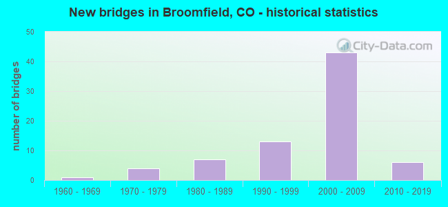
- New bridges - historical statistics
- 11960-1969
- 41970-1979
- 71980-1989
- 131990-1999
- 432000-2009
- 62010-2019
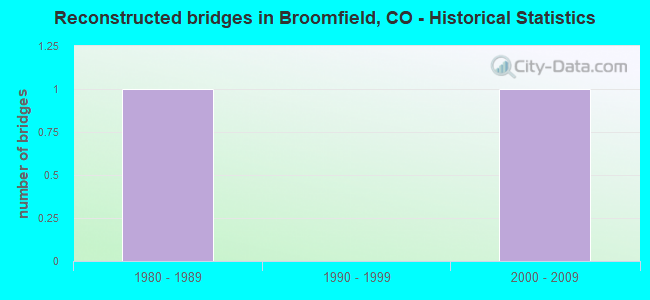
- Reconstructed bridges - Historical Statistics
- 11980-1989
- 01990-1999
- 12000-2009

- Bridge Condition - Deck
- 8.8%Very good
- 73.5%Good
- 11.8%Satisfactory
- 2.9%Fair
- 2.9%Poor
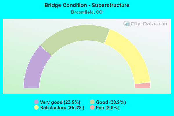
- Bridge Condition - Superstructure
- 23.5%Very good
- 38.2%Good
- 35.3%Satisfactory
- 2.9%Fair
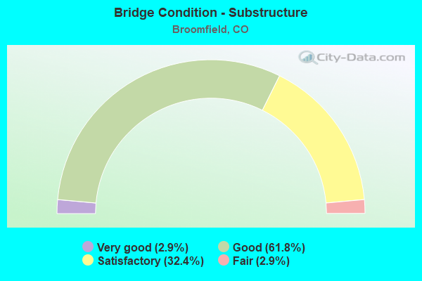
- Bridge Condition - Substructure
- 2.9%Very good
- 61.8%Good
- 32.4%Satisfactory
- 2.9%Fair
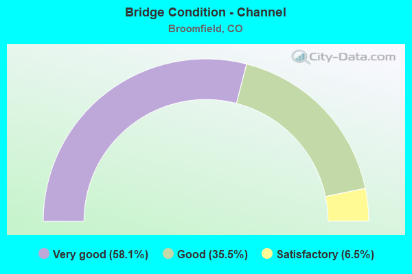
- Bridge Condition - Channel
- 58.1%Very good
- 35.5%Good
- 6.5%Satisfactory
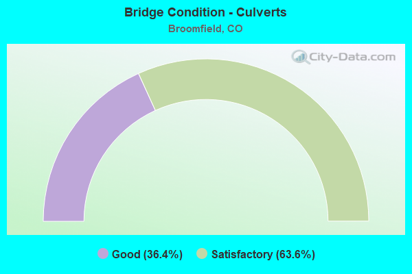
- Bridge Condition - Culverts
- 36.4%Good
- 63.6%Satisfactory
Find on map >> Show street view
Structure Number: E-16-YB, Location: IN BROOMFIELD (Lat: 39.916083, Lng: -105.094772), Route carried "on" structure: State highway 121A, Year Built: 2014, Status: Open, Structure Length: 9.13m (29.95ft), Average Daily Traffic: 39,000 (year 2020), Truck Traffic: 2%, Average Future Daily Traffic: 47,970 (year 2040), Design Load: HL 93, Features Intersected: US 36 ML, Facility Carried by Structure: SH 121 ML
Minimum Vertical Clearance: 30+ m (98+ ft), Kilometerpoint: 41.133, Lanes on structure: 7, Lanes under structure: 7, Base Highway Network: Yes, Owner: State Highway Agency, Approaching Roadway Width: 33.7m (110.6ft), Skew: 22 degrees, Material/Design: Prestressed concrete continuous, Design/Construction: Stringer/Multi-beam, Number Of Spans In Main Unit: 3, Length of Maximum Span: 35.9m (117.8ft), Curb or Sidewalk Widths: Left: 2.0m (6.6ft), Right: 2.0m (6.6ft), Curb-To-Curb Width: 33.7m (110.6ft), Out-to-Out Width: 40.8m (133.9ft)
Condition: Deck: Good, Superstructure: Very good, Substructure: Good, Operating Rating: 48.6 metric tons, Method Used To Determine Operating Rating: Load and Resistance Factor Rating (LRFR) rating reported by rating factor(RF) method using HL-93 loadings, Inventory Rating: 36.9 metric tons, Method Used To Determine Inventory Rating: Load and Resistance Factor Rating (LRFR) rating reported by rating factor(RF) method using HL-93 loadings, Structural Evaluation: Better than present minimum criteria, Deck Geometry: Superior to present desirable criteria, Underclear: Equal to present minimum criteria, Approach Roadway Alignment: Equal to present desirable criteria, Length Of Structure Improvement: 7.04m (23.10ft), Designated Inspection Frequency: Every 24 months, Inspection Date: Febuary 2021, Bridge Improvement Cost: $498,000, Roadway Improvement Cost: $50,000, Total Project Cost: $758,000, Deck Structure Type: Concrete Cast-file-Place, Wearing Surface/Protective System: Wearing Surface: Bituminous
Find on map >> Show street view
Structure Number: E-16-ZD, Location: _ (Lat: 39.935989, Lng: -105.130708), Route carried "on" structure: US 36B, Year Built: 2015, Status: Open, Structure Length: 1.12m (3.67ft), Average Daily Traffic: 68,000 (year 2020), Truck Traffic: 2%, Average Future Daily Traffic: 77,520 (year 2040), Design Load: HL 93, Features Intersected: ROCK CREEK, Facility Carried by Structure: US 36 ML
Minimum Vertical Clearance: 30+ m (98+ ft), Kilometerpoint: 73.611, Lanes on structure: 9, Base Highway Network: Yes, Owner: State Highway Agency, Approaching Roadway Width: 60.5m (198.5ft), Skew: 30 degrees, Material/Design: Concrete, Design/Construction: Culvert, Number Of Spans In Main Unit: 2, Length of Maximum Span: 5.5m (18.0ft), Out-to-Out Width: 73.3m (240.5ft)
Condition: Channel: Very good, Culverts: Good, Operating Rating: 59.6 metric tons, Method Used To Determine Operating Rating: Load and Resistance Factor (LRFR), Inventory Rating: 46.0 metric tons, Method Used To Determine Inventory Rating: Load and Resistance Factor (LRFR), Structural Evaluation: Better than present minimum criteria, Waterway Adequacy: Equal to present desirable criteria, Approach Roadway Alignment: Equal to present desirable criteria, Designated Inspection Frequency: Every 24 months, Inspection Date: July 2021
Find on map >> Show street view
Structure Number: E-17-MW, Location: I25 LAFAYETTE INTERCHANGE (Lat: 40.000428, Lng: -104.980447), Route carried "on" structure: State highway 7D, Year Built: 1987, Status: Open, Structure Length: 7.27m (23.85ft), Average Daily Traffic: 27,000 (year 2020), Truck Traffic: 5%, Average Future Daily Traffic: 38,610 (year 2040), Design Load: HS 20, Features Intersected: I 25 ML, Facility Carried by Structure: SH 7 ML
Minimum Vertical Clearance: 30+ m (98+ ft), Kilometerpoint: 10.458, Lanes on structure: 7, Lanes under structure: 6, Base Highway Network: Yes, Owner: State Highway Agency, Approaching Roadway Width: 25.6m (84.0ft), Skew: 1 degrees, Material/Design: Prestressed concrete continuous, Design/Construction: Stringer/Multi-beam, Number Of Spans In Main Unit: 2, Length of Maximum Span: 38.4m (126.0ft), Curb-To-Curb Width: 25.6m (84.0ft), Out-to-Out Width: 26.4m (86.6ft)
Condition: Deck: Good, Superstructure: Very good, Substructure: Good, Operating Rating: 67.5 metric tons, Method Used To Determine Operating Rating: Load Factor (LF), Inventory Rating: 26.7 metric tons, Method Used To Determine Inventory Rating: Load Factor (LF), Structural Evaluation: Equal to present minimum criteria, Deck Geometry: Meets minimum limits, Underclear: Equal to present minimum criteria, Approach Roadway Alignment: Equal to present desirable criteria, Designated Inspection Frequency: Every 24 months, Inspection Date: Febuary 2020, Deck Structure Type: Concrete Cast-file-Place, Wearing Surface/Protective System: Wearing Surface: Bituminous, Membrane: Preformed Fabric, Deck Protection: Epoxy Coated Reinforcing
Find on map >> Show street view
Structure Number: E-17-ZN, Location: Just N of NWPkwy-470 (Lat: 39.986572, Lng: -104.988403), Route carried "on" structure: City street , Year Built: 2003, Status: Open, Structure Length: 9.95m (32.64ft), Average Daily Traffic: 2,647 (year 2020), Truck Traffic: 1%, Average Future Daily Traffic: 3,334 (year 2028), Design Load: HS 25 or greater, Features Intersected: I-25, Facility Carried by Structure: 160TH AVE
Minimum Vertical Clearance: 30+ m (98+ ft), Kilometerpoint: 4.371, Lanes on structure: 2, Lanes under structure: 10, Owner: State Highway Agency, Approaching Roadway Width: 12.2m (40.0ft), Skew: 1 degrees, Material/Design: Prestressed concrete continuous, Design/Construction: Stringer/Multi-beam, Number Of Spans In Main Unit: 2, Length of Maximum Span: 49.4m (162.1ft), Curb-To-Curb Width: 12.2m (40.0ft), Out-to-Out Width: 13.1m (43.0ft)
Condition: Deck: Good, Superstructure: Good, Substructure: Good, Operating Rating: 87.2 metric tons, Method Used To Determine Operating Rating: Load Factor (LF), Inventory Rating: 52.2 metric tons, Method Used To Determine Inventory Rating: Load Factor (LF), Structural Evaluation: Better than present minimum criteria, Deck Geometry: Equal to present minimum criteria, Underclear: Superior to present desirable criteria, Approach Roadway Alignment: Equal to present desirable criteria, Designated Inspection Frequency: Every 24 months, Inspection Date: April 2021, Deck Structure Type: Concrete Precast Panels, Wearing Surface/Protective System: Wearing Surface: Bituminous, Membrane: Built-up, Deck Protection: Epoxy Coated Reinforcing
Find on map >> Show street view
Structure Number: E-17-ZP, Location: Just South of 160th Ave (Lat: 39.981228, Lng: -104.988136), Route carried "on" structure: Interstate 25A, Year Built: 2003, Status: Open, Structure Length: 7.70m (25.26ft), Average Daily Traffic: 54,000 (year 2020), Truck Traffic: 8%, Average Future Daily Traffic: 78,300 (year 2040), Design Load: HS 25 or greater, Features Intersected: NWP/E470, Facility Carried by Structure: SB I-25
Minimum Vertical Clearance: 5.49m (18.01ft), Kilometerpoint: 366.185, Lanes on structure: 3, Lanes under structure: 4, Base Highway Network: Yes, Toll: On Interstate toll segment, Owner: State Highway Agency, Approaching Roadway Width: 16.9m (55.4ft), Skew: 31 degrees, Material/Design: Prestressed concrete continuous, Design/Construction: Stringer/Multi-beam, Number Of Spans In Main Unit: 2, Length of Maximum Span: 37.0m (121.4ft), Curb-To-Curb Width: 16.9m (55.4ft), Out-to-Out Width: 17.8m (58.4ft)
Condition: Deck: Good, Superstructure: Very good, Substructure: Good, Operating Rating: 67.8 metric tons, Method Used To Determine Operating Rating: Load Factor (LF), Inventory Rating: 40.6 metric tons, Method Used To Determine Inventory Rating: Load Factor (LF), Structural Evaluation: Better than present minimum criteria, Deck Geometry: Equal to present minimum criteria, Underclear: Superior to present desirable criteria, Approach Roadway Alignment: Equal to present desirable criteria, Designated Inspection Frequency: Every 24 months, Inspection Date: April 2021, Deck Structure Type: Concrete Precast Panels, Wearing Surface/Protective System: Wearing Surface: Bituminous, Membrane: Preformed Fabric, Deck Protection: Epoxy Coated Reinforcing
Find on map >> Show street view
Structure Number: NWP-0.5, Location: 0.50 MI FROM I25 (Lat: 39.983400, Lng: -104.997197), Route carried "on" structure: City street HURON, Year Built: 2002, Status: Open, Structure Length: 8.53m (27.99ft), Average Daily Traffic: 5,000 (year 2009), Average Future Daily Traffic: 10,000 (year 2029), Design Load: HS 25 or greater, Features Intersected: NWP, Facility Carried by Structure: Huron Street
Minimum Vertical Clearance: 30.17m (98.98ft), Kilometerpoint: 1.678, Lanes on structure: 2, Lanes under structure: 6, Owner: Local Toll Authority, Approaching Roadway Width: 12.6m (41.3ft), Skew: 1 degrees, Material/Design: Prestressed concrete continuous, Design/Construction: Stringer/Multi-beam, Number Of Spans In Main Unit: 2, Length of Maximum Span: 45.8m (150.3ft), Curb-To-Curb Width: 12.2m (40.0ft), Out-to-Out Width: 13.1m (43.0ft)
Condition: Deck: Good, Superstructure: Satisfactory, Substructure: Satisfactory, Operating Rating: 36.3 metric tons, Method Used To Determine Operating Rating: Field evaluation and documented engineering judgment, Inventory Rating: 32.7 metric tons, Method Used To Determine Inventory Rating: Field evaluation and documented engineering judgment, Structural Evaluation: Equal to present minimum criteria, Deck Geometry: Equal to present minimum criteria, Underclear: Superior to present desirable criteria, Approach Roadway Alignment: Equal to present desirable criteria, Designated Inspection Frequency: Every 24 months, Inspection Date: June 2021, Deck Structure Type: Concrete Precast Panels, Wearing Surface/Protective System: Wearing Surface: Bituminous, Membrane: Built-up, Deck Protection: Epoxy Coated Reinforcing
Find on map >> Show street view
Structure Number: NWP-01.64, Location: 1.64 MI FROM I-25 (Lat: 39.984156, Lng: -105.018467), Route carried "on" structure: City street SHRDN, Year Built: 2002, Status: Open, Structure Length: 7.48m (24.54ft), Average Daily Traffic: 5,000 (year 2009), Truck Traffic: 5%, Average Future Daily Traffic: 10,000 (year 2029), Design Load: HS 25 or greater, Features Intersected: NWP, Facility Carried by Structure: Sheridan Parkway
Minimum Vertical Clearance: 30.17m (98.98ft), Kilometerpoint: 10.253, Lanes on structure: 3, Lanes under structure: 4, Owner: Local Toll Authority, Approaching Roadway Width: 9.2m (30.2ft), Skew: 1 degrees, Material/Design: Prestressed concrete continuous, Design/Construction: Stringer/Multi-beam, Number Of Spans In Main Unit: 2, Length of Maximum Span: 35.9m (117.8ft), Curb-To-Curb Width: 12.2m (40.0ft), Out-to-Out Width: 13.1m (43.0ft)
Condition: Deck: Good, Superstructure: Satisfactory, Substructure: Good, Operating Rating: 36.3 metric tons, Method Used To Determine Operating Rating: Field evaluation and documented engineering judgment, Inventory Rating: 32.7 metric tons, Method Used To Determine Inventory Rating: Field evaluation and documented engineering judgment, Structural Evaluation: Equal to present minimum criteria, Deck Geometry: Meets minimum limits, Underclear: Superior to present desirable criteria, Approach Roadway Alignment: Equal to present desirable criteria, Designated Inspection Frequency: Every 24 months, Inspection Date: June 2021, Deck Structure Type: Concrete Precast Panels, Wearing Surface/Protective System: Wearing Surface: Bituminous, Deck Protection: Epoxy Coated Reinforcing
Find on map >> Show street view
Structure Number: NWP-02.56, Location: 2.56 MILES FROM I-25 (Lat: 39.981475, Lng: -105.018467), Route carried "on" structure: City street LOWEL, Year Built: 2002, Status: Open, Structure Length: 8.00m (26.25ft), Average Daily Traffic: 5,282 (year 2020), Truck Traffic: 10%, Average Future Daily Traffic: 10,000 (year 2029), Design Load: HS 25 or greater, Features Intersected: NWP, Facility Carried by Structure: Lowell Blvd.
Minimum Vertical Clearance: 30.17m (98.98ft), Kilometerpoint: 16.093, Lanes on structure: 2, Lanes under structure: 5, Owner: Local Toll Authority, Approaching Roadway Width: 10.4m (34.1ft), Material/Design: Prestressed concrete continuous, Design/Construction: Stringer/Multi-beam, Number Of Spans In Main Unit: 2, Length of Maximum Span: 42.4m (139.1ft), Curb or Sidewalk Widths: Left: 2.6m (8.5ft), Right: 2.6m (8.5ft), Curb-To-Curb Width: 10.4m (34.1ft), Out-to-Out Width: 16.5m (54.1ft)
Condition: Deck: Good, Superstructure: Satisfactory, Substructure: Good, Operating Rating: 36.3 metric tons, Method Used To Determine Operating Rating: Field evaluation and documented engineering judgment, Inventory Rating: 32.7 metric tons, Method Used To Determine Inventory Rating: Field evaluation and documented engineering judgment, Structural Evaluation: Equal to present minimum criteria, Deck Geometry: Meets minimum limits, Underclear: Equal to present minimum criteria, Approach Roadway Alignment: Equal to present desirable criteria, Designated Inspection Frequency: Every 24 months, Inspection Date: June 2021, Deck Structure Type: Concrete Precast Panels, Wearing Surface/Protective System: Wearing Surface: Bituminous, Deck Protection: Epoxy Coated Reinforcing
Find on map >> Show street view
Structure Number: NWP-04.77, Location: 4.77 MI FROM I-25 (Lat: 39.967239, Lng: -105.071908), Route carried "on" structure: City street 120TH, Year Built: 2002, Status: Open, Structure Length: 8.85m (29.04ft), Average Daily Traffic: 4,189 (year 2020), Truck Traffic: 5%, Average Future Daily Traffic: 10,000 (year 2029), Design Load: HS 25 or greater, Features Intersected: NWP
Minimum Vertical Clearance: 30.17m (98.98ft), Kilometerpoint: 0.091, Lanes on structure: 2, Lanes under structure: 4, Owner: Local Toll Authority, Approaching Roadway Width: 11.0m (36.1ft), Skew: 5 degrees, Material/Design: Prestressed concrete continuous, Design/Construction: Stringer/Multi-beam, Number Of Spans In Main Unit: 2, Length of Maximum Span: 42.4m (139.1ft), Curb-To-Curb Width: 11.0m (36.1ft), Out-to-Out Width: 11.9m (39.0ft)
Condition: Deck: Good, Superstructure: Satisfactory, Substructure: Satisfactory, Operating Rating: 36.3 metric tons, Method Used To Determine Operating Rating: Field evaluation and documented engineering judgment, Inventory Rating: 32.7 metric tons, Method Used To Determine Inventory Rating: Field evaluation and documented engineering judgment, Structural Evaluation: Equal to present minimum criteria, Deck Geometry: Somewhat better than minimum adequacy, Underclear: Superior to present desirable criteria, Approach Roadway Alignment: Equal to present desirable criteria, Designated Inspection Frequency: Every 24 months, Inspection Date: June 2021, Deck Structure Type: Concrete Cast-file-Place, Wearing Surface/Protective System: Wearing Surface: Bituminous, Deck Protection: Epoxy Coated Reinforcing
Find on map >> Show street view
Structure Number: NWP-05.57, Location: 5.57 MI FROM I-25 (Lat: 39.959331, Lng: -105.083078), Route carried "on" structure: Ramp Other road NWPKY, Year Built: 2002, Status: Open, Structure Length: 2.88m (9.45ft), Average Daily Traffic: 2,500 (year 2018), Truck Traffic: 5%, Average Future Daily Traffic: 2,000 (year 2029), Design Load: HS 25 or greater, Features Intersected: WB Dillon Road, Facility Carried by Structure: NWP Ramp
Minimum Vertical Clearance: 30.17m (98.98ft), Kilometerpoint: 1.427, Lanes on structure: 1, Lanes under structure: 2, Base Highway Network: Yes, Toll: On toll road, Owner: Local Toll Authority, Approaching Roadway Width: 7.8m (25.6ft), Skew: 2 degrees, Material/Design: Prestressed concrete, Design/Construction: Stringer/Multi-beam, Number Of Spans In Main Unit: 1, Length of Maximum Span: 27.4m (89.9ft), Curb-To-Curb Width: 7.7m (25.3ft), Out-to-Out Width: 8.6m (28.2ft)
Condition: Deck: Good, Superstructure: Satisfactory, Substructure: Satisfactory, Operating Rating: 36.3 metric tons, Method Used To Determine Operating Rating: Field evaluation and documented engineering judgment, Inventory Rating: 32.7 metric tons, Method Used To Determine Inventory Rating: Field evaluation and documented engineering judgment, Structural Evaluation: Equal to present minimum criteria, Deck Geometry: Better than present minimum criteria, Underclear: Superior to present desirable criteria, Approach Roadway Alignment: Equal to present desirable criteria, Designated Inspection Frequency: Every 24 months, Inspection Date: June 2021, Deck Structure Type: Concrete Precast Panels, Wearing Surface/Protective System: Wearing Surface: Bituminous, Deck Protection: Epoxy Coated Reinforcing
Find on map >> Show street view
Structure Number: NWP-05.59A, Location: 5.59 MI FROM I-25 (Lat: 39.959331, Lng: -105.083400), Route carried "on" structure: Other road NWPKW, Year Built: 2002, Status: Open, Structure Length: 3.87m (12.70ft), Average Daily Traffic: 2,500 (year 2018), Truck Traffic: 10%, Average Future Daily Traffic: 20,000 (year 2029), Design Load: HS 25 or greater, Features Intersected: WB Dillon Road, Facility Carried by Structure: NWP EB
Minimum Vertical Clearance: 30.17m (98.98ft), Kilometerpoint: 0.475, Lanes on structure: 2, Lanes under structure: 2, Base Highway Network: Yes, Toll: On toll road, Owner: Local Toll Authority, Approaching Roadway Width: 12.3m (40.4ft), Skew: 4 degrees, Material/Design: Prestressed concrete, Design/Construction: Stringer/Multi-beam, Number Of Spans In Main Unit: 1, Length of Maximum Span: 37.1m (121.7ft), Curb-To-Curb Width: 12.3m (40.4ft), Out-to-Out Width: 13.2m (43.3ft)
Condition: Deck: Good, Superstructure: Satisfactory, Substructure: Good, Operating Rating: 36.3 metric tons, Method Used To Determine Operating Rating: Field evaluation and documented engineering judgment, Inventory Rating: 32.7 metric tons, Method Used To Determine Inventory Rating: Field evaluation and documented engineering judgment, Structural Evaluation: Equal to present minimum criteria, Deck Geometry: Better than present minimum criteria, Underclear: Superior to present desirable criteria, Approach Roadway Alignment: Equal to present desirable criteria, Designated Inspection Frequency: Every 24 months, Inspection Date: June 2021, Deck Structure Type: Concrete Cast-file-Place, Wearing Surface/Protective System: Wearing Surface: Bituminous, Deck Protection: Epoxy Coated Reinforcing
Find on map >> Show street view
Structure Number: NWP-05.59B, Location: 5.59 MI FROM I-25 (Lat: 39.959686, Lng: -105.083697), Route carried "on" structure: Other road NWPKW, Year Built: 2002, Status: Open, Structure Length: 3.87m (12.70ft), Average Daily Traffic: 12,000 (year 2018), Truck Traffic: 10%, Average Future Daily Traffic: 16,320 (year 2038), Design Load: HS 25 or greater, Features Intersected: WB Dillon Road, Facility Carried by Structure: NWP WB
Minimum Vertical Clearance: 30.17m (98.98ft), Kilometerpoint: 9.009, Lanes on structure: 2, Lanes under structure: 2, Base Highway Network: Yes, Toll: On toll road, Owner: Local Toll Authority, Approaching Roadway Width: 12.4m (40.7ft), Skew: 4 degrees, Material/Design: Prestressed concrete, Design/Construction: Stringer/Multi-beam, Number Of Spans In Main Unit: 1, Length of Maximum Span: 37.1m (121.7ft), Curb-To-Curb Width: 12.3m (40.4ft), Out-to-Out Width: 13.2m (43.3ft)
Condition: Deck: Good, Superstructure: Satisfactory, Substructure: Good, Operating Rating: 36.3 metric tons, Method Used To Determine Operating Rating: Field evaluation and documented engineering judgment, Inventory Rating: 32.7 metric tons, Method Used To Determine Inventory Rating: Field evaluation and documented engineering judgment, Structural Evaluation: Equal to present minimum criteria, Deck Geometry: Better than present minimum criteria, Underclear: Superior to present desirable criteria, Approach Roadway Alignment: Equal to present desirable criteria, Designated Inspection Frequency: Every 24 months, Inspection Date: June 2021, Deck Structure Type: Concrete Cast-file-Place, Wearing Surface/Protective System: Wearing Surface: Bituminous, Deck Protection: Epoxy Coated Reinforcing
Find on map >> Show street view
Structure Number: NWP-05.68A, Location: 5.68 MI FROM I-25 (Lat: 39.959089, Lng: -105.085478), Route carried "on" structure: Other road NWPKY, Year Built: 2002, Status: Open, Structure Length: 7.57m (24.84ft), Average Daily Traffic: 15,000 (year 2009), Truck Traffic: 10%, Average Future Daily Traffic: 25,000 (year 2029), Design Load: HS 25 or greater, Features Intersected: Rock Creek, Facility Carried by Structure: NWP EB
Minimum Vertical Clearance: 30.17m (98.98ft), Kilometerpoint: 9.107, Lanes on structure: 2, Base Highway Network: Yes, Toll: On toll road, Owner: Local Toll Authority, Approaching Roadway Width: 12.3m (40.4ft), Material/Design: Prestressed concrete continuous, Design/Construction: Stringer/Multi-beam, Number Of Spans In Main Unit: 2, Length of Maximum Span: 41.3m (135.5ft), Curb-To-Curb Width: 12.3m (40.4ft), Out-to-Out Width: 13.3m (43.6ft)
Condition: Deck: Good, Superstructure: Satisfactory, Substructure: Satisfactory, Channel: Good, Operating Rating: 36.3 metric tons, Method Used To Determine Operating Rating: Field evaluation and documented engineering judgment, Inventory Rating: 32.7 metric tons, Method Used To Determine Inventory Rating: Field evaluation and documented engineering judgment, Structural Evaluation: Equal to present minimum criteria, Deck Geometry: Better than present minimum criteria, Waterway Adequacy: Equal to present desirable criteria, Approach Roadway Alignment: Equal to present desirable criteria, Designated Inspection Frequency: Every 24 months, Inspection Date: May 2021, Deck Structure Type: Concrete Precast Panels, Wearing Surface/Protective System: Wearing Surface: Bituminous, Deck Protection: Epoxy Coated Reinforcing
Find on map >> Show street view
Structure Number: NWP-05.68B, Location: 5.68 MI FROM I-25 (Lat: 39.959286, Lng: -105.085492), Route carried "on" structure: Other road 470N, Year Built: 2002, Status: Open, Structure Length: 7.57m (24.84ft), Average Daily Traffic: 12,000 (year 2018), Truck Traffic: 10%, Average Future Daily Traffic: 16,320 (year 2038), Design Load: HS 25 or greater, Features Intersected: Rock Creek, Facility Carried by Structure: NWP WB
Minimum Vertical Clearance: 30.18m (99.02ft), Kilometerpoint: 9.167, Lanes on structure: 2, Base Highway Network: Yes, Toll: On toll road, Owner: Local Toll Authority, Approaching Roadway Width: 12.3m (40.4ft), Material/Design: Prestressed concrete continuous, Design/Construction: Stringer/Multi-beam, Number Of Spans In Main Unit: 2, Length of Maximum Span: 41.3m (135.5ft), Curb-To-Curb Width: 12.3m (40.4ft), Out-to-Out Width: 13.3m (43.6ft)
Condition: Deck: Good, Superstructure: Satisfactory, Substructure: Satisfactory, Channel: Good, Operating Rating: 36.3 metric tons, Method Used To Determine Operating Rating: Field evaluation and documented engineering judgment, Inventory Rating: 32.7 metric tons, Method Used To Determine Inventory Rating: Field evaluation and documented engineering judgment, Structural Evaluation: Equal to present minimum criteria, Deck Geometry: Better than present minimum criteria, Waterway Adequacy: Equal to present desirable criteria, Approach Roadway Alignment: Equal to present desirable criteria, Designated Inspection Frequency: Every 24 months, Inspection Date: May 2021, Deck Structure Type: Concrete Precast Panels, Wearing Surface/Protective System: Wearing Surface: Bituminous, Deck Protection: Epoxy Coated Reinforcing
Find on map >> Show street view
Structure Number: NWP-05.7, Location: 5.70 MI FROM I-25 (Lat: 39.959931, Lng: -105.085556), Route carried "on" structure: Ramp Other road 470N, Year Built: 2002, Status: Open, Structure Length: 4.94m (16.21ft), Average Daily Traffic: 2,300 (year 2018), Truck Traffic: 10%, Average Future Daily Traffic: 10,000 (year 2029), Design Load: HS 25 or greater, Features Intersected: Rock Creek, Facility Carried by Structure: WB NWP Ramp
Minimum Vertical Clearance: 30.17m (98.98ft), Kilometerpoint: 0.027, Lanes on structure: 2, Base Highway Network: Yes, Toll: On toll road, Owner: Local Toll Authority, Maintenance Responsibility: County Highway Agency, Approaching Roadway Width: 13.0m (42.7ft), Skew: 1 degrees, Material/Design: Prestressed concrete, Design/Construction: Stringer/Multi-beam, Number Of Spans In Main Unit: 1, Length of Maximum Span: 48.2m (158.1ft), Curb-To-Curb Width: 13.0m (42.7ft), Out-to-Out Width: 13.9m (45.6ft)
Condition: Deck: Good, Superstructure: Satisfactory, Substructure: Satisfactory, Channel: Good, Operating Rating: 36.3 metric tons, Method Used To Determine Operating Rating: Field evaluation and documented engineering judgment, Inventory Rating: 32.7 metric tons, Method Used To Determine Inventory Rating: Field evaluation and documented engineering judgment, Structural Evaluation: Equal to present minimum criteria, Deck Geometry: Superior to present desirable criteria, Waterway Adequacy: Equal to present desirable criteria, Approach Roadway Alignment: Equal to present desirable criteria, Designated Inspection Frequency: Every 24 months, Inspection Date: March 2022, Deck Structure Type: Concrete Precast Panels, Wearing Surface/Protective System: Wearing Surface: Bituminous, Deck Protection: Epoxy Coated Reinforcing
Find on map >> Show street view
Structure Number: 46.28, Location: I25 NB ramp to NWP WB (Lat: 39.982222, Lng: -104.989444), Route carried "under" structure: Ramp Interstate 25A, Year Built: 2003, Structure Length: 0. m, Average Daily Traffic: 85,600 (year 2007), Truck Traffic: 15%, Features Intersected: I-25 and NWP, Facility Carried by Structure: Ramp B
Minimum Vertical Clearance: 5.03m (16.50ft), Kilometerpoint: 365.548, Lanes on structure: 1, Lanes under structure: 10, Material/Design: Steel continuous, Design/Construction: Stringer/Multi-beam, Length of Maximum Span: 67.3m (220.8ft)
Find on map >> Show street view
Structure Number: 46.43, Location: EB NWP ramp to NB I25 (Lat: 39.981389, Lng: -104.990833), Route carried "under" structure: Interstate 25A, Year Built: 2003, Structure Length: 0. m, Average Daily Traffic: 85,600 (year 2007), Truck Traffic: 15%, Features Intersected: I-25 and NWP, Facility Carried by Structure: Ramp H
Minimum Vertical Clearance: 7.62m (25.00ft), Kilometerpoint: 365.514, Lanes on structure: 1, Lanes under structure: 4, Material/Design: Steel continuous, Design/Construction: Stringer/Multi-beam, Length of Maximum Span: 52.2m (171.3ft)
Find on map >> Show street view
Structure Number: BFD-INTLE-W.FLT, Location: 400 Ft N. of Interlocken (Lat: 39.930542, Lng: -105.127656), Route carried "under" structure: County highway , Year Built: 2000, Structure Length: 0. m, Average Daily Traffic: 19,784 (year 2007), Truck Traffic: 2%, Features Intersected: W. Flatiron Crossing Dr., Facility Carried by Structure: Interlocken Loop N
Minimum Vertical Clearance: 30+ m (98+ ft), Kilometerpoint: 0.000, Lanes on structure: 3, Lanes under structure: 7, Material/Design: Prestressed concrete continuous, Design/Construction: Stringer/Multi-beam, Length of Maximum Span: 21.9m (71.9ft)
Find on map >> Show street view
Structure Number: BFD-INTLW-W.FLT, Location: 400 Ft N. of Interlocken (Lat: 39.930531, Lng: -105.127925), Route carried "under" structure: County highway , Year Built: 2000, Structure Length: 0. m, Average Daily Traffic: 24,821 (year 2007), Truck Traffic: 6%, Features Intersected: W. Flatiron Crossing, Facility Carried by Structure: Interlocken Loop S
Minimum Vertical Clearance: 30+ m (98+ ft), Kilometerpoint: 0.000, Lanes on structure: 3, Lanes under structure: 7, Material/Design: Prestressed concrete continuous, Design/Construction: Stringer/Multi-beam, Length of Maximum Span: 21.9m (71.9ft)
Find on map >> Show street view
Structure Number: E-16-HR, Location: IN BROOMFIELD (Lat: 39.918114, Lng: -105.090975), Route carried "under" structure: Spur US 287C, Year Built: 1972, Structure Length: 0. m, Average Daily Traffic: 27,000 (year 2011), Truck Traffic: 3%, Features Intersected: US 287 ML, RR SPUR, Facility Carried by Structure: SH 121 ML NBND
Minimum Vertical Clearance: 8.13m (26.67ft), Kilometerpoint: 479.673, Lanes on structure: 2, Lanes under structure: 4, Material/Design: Steel continuous, Design/Construction: Stringer/Multi-beam, Length of Maximum Span: 34.6m (113.5ft)
Find on map >> Show street view
Structure Number: E-16-HS, Location: IN BROOMFIELD (Lat: 39.918194, Lng: -105.091142), Route carried "under" structure: Spur US 287C, Year Built: 1972, Structure Length: 0. m, Average Daily Traffic: 27,000 (year 2011), Truck Traffic: 3%, Features Intersected: US 287 ML, RR SPUR, Facility Carried by Structure: SH 121 ML SBND
Minimum Vertical Clearance: 7.88m (25.85ft), Kilometerpoint: 479.675, Lanes on structure: 3, Lanes under structure: 4, Material/Design: Steel continuous, Design/Construction: Stringer/Multi-beam, Length of Maximum Span: 34.9m (114.5ft)
Find on map >> Show street view
Structure Number: E-16-QI, Location: IN BROOMFIELD (Lat: 39.934442, Lng: -105.127242), Route carried "under" structure: US 36B, Year Built: 1995, Structure Length: 0. m, Average Daily Traffic: 26,086 (year 2016), Truck Traffic: 4%, Features Intersected: US 36 ML, Facility Carried by Structure: 96TH STREET
Minimum Vertical Clearance: 18.17m (59.61ft), Kilometerpoint: 0.060, Lanes on structure: 4, Lanes under structure: 4, Material/Design: Prestressed concrete continuous, Design/Construction: Stringer/Multi-beam, Length of Maximum Span: 36.6m (120.1ft)
Find on map >> Show street view
Structure Number: E-16-QU, Location: 3.5 MI W. OF SH 121 (Lat: 39.945217, Lng: -105.146939), Route carried "under" structure: US 36B, Year Built: 2000, Structure Length: 0. m, Average Daily Traffic: 9,559 (year 2016), Truck Traffic: 4%, Features Intersected: US 36 ML, Facility Carried by Structure: 88TH ST.
Minimum Vertical Clearance: 5.64m (18.50ft), Kilometerpoint: 0.941, Lanes on structure: 2, Lanes under structure: 4, Material/Design: Prestressed concrete continuous, Design/Construction: Stringer/Multi-beam, Length of Maximum Span: 48.9m (160.4ft)
Find on map >> Show street view
Structure Number: E-16-XU, Location: 120TH AVE AND US 36 (Lat: 39.911192, Lng: -105.088842), Route carried "under" structure: US 36B, Year Built: 2011, Structure Length: 0. m, Average Daily Traffic: 82,000 (year 2011), Truck Traffic: 2%, Features Intersected: US 36 ML, Facility Carried by Structure: SH 128 (120TH AVE)
Minimum Vertical Clearance: 5.05m (16.57ft), Kilometerpoint: 78.037, Lanes on structure: 6, Lanes under structure: 4, Material/Design: Prestressed concrete continuous, Design/Construction: Stringer/Multi-beam, Length of Maximum Span: 45.3m (148.6ft)
Find on map >> Show street view
Structure Number: E-16-YB, Location: IN BROOMFIELD (Lat: 39.916083, Lng: -105.094772), Route carried "under" structure: US 36B, Year Built: 2014, Structure Length: 0. m, Average Daily Traffic: 82,000 (year 2011), Truck Traffic: 4%, Features Intersected: US 36 ML, Facility Carried by Structure: SH 121 ML
Minimum Vertical Clearance: 5.30m (17.39ft), Kilometerpoint: 77.288, Lanes on structure: 7, Lanes under structure: 6, Material/Design: Prestressed concrete continuous, Design/Construction: Stringer/Multi-beam, Length of Maximum Span: 35.9m (117.8ft)
Find on map >> Show street view
Structure Number: E-17-MW, Location: I25 LAFAYETTE INTERCHANGE (Lat: 40.000428, Lng: -104.980447), Route carried "under" structure: Interstate 25A, Year Built: 1987, Structure Length: 0. m, Average Daily Traffic: 95,000 (year 2011), Truck Traffic: 7%, Features Intersected: I 25 ML, Facility Carried by Structure: SH 7 ML
Minimum Vertical Clearance: 5.82m (19.09ft), Kilometerpoint: 368.712, Lanes on structure: 7, Lanes under structure: 6, Material/Design: Prestressed concrete continuous, Design/Construction: Stringer/Multi-beam, Length of Maximum Span: 38.4m (126.0ft)
Find on map >> Show street view
Structure Number: E-17-ZK, Location: JUST S OF 160TH AVE (Lat: 39.981222, Lng: -104.987886), Route carried "under" structure: Other road , Year Built: 2002, Structure Length: 0. m, Features Intersected: NWP, Facility Carried by Structure: I 25 ML NBND
Minimum Vertical Clearance: 5.88m (19.29ft), Kilometerpoint: 0.000, Lanes on structure: 3, Lanes under structure: 4, Toll: On toll road, Material/Design: Prestressed concrete continuous, Design/Construction: Stringer/Multi-beam, Length of Maximum Span: 37.0m (121.4ft)
Find on map >> Show street view
Structure Number: E-17-ZN, Location: Just N of NWPkwy-470 (Lat: 39.986572, Lng: -104.988403), Route carried "under" structure: Interstate 25A, Year Built: 2003, Structure Length: 0. m, Average Daily Traffic: 3,949 (year 2016), Truck Traffic: 13%, Features Intersected: I-25, Facility Carried by Structure: 160TH AVE
Minimum Vertical Clearance: 5.72m (18.77ft), Kilometerpoint: 4.371, Lanes on structure: 2, Lanes under structure: 10, Material/Design: Prestressed concrete continuous, Design/Construction: Stringer/Multi-beam, Length of Maximum Span: 49.4m (162.1ft)
Find on map >> Show street view
Structure Number: E-17-ZP, Location: Just South of 160th Ave (Lat: 39.981228, Lng: -104.988136), Route carried "under" structure: Other road , Year Built: 2003, Structure Length: 0. m, Features Intersected: NWP/E470, Facility Carried by Structure: SB I-25
Minimum Vertical Clearance: 5.73m (18.80ft), Kilometerpoint: 0.000, Lanes on structure: 3, Lanes under structure: 4, Toll: On toll road, Material/Design: Prestressed concrete continuous, Design/Construction: Stringer/Multi-beam, Length of Maximum Span: 37.0m (121.4ft)
Find on map >> Show street view
Structure Number: NWP-0.5, Location: 0.50 MI FROM I25 (Lat: 39.983400, Lng: -104.997197), Route carried "under" structure: Other road 470N, Year Built: 2002, Structure Length: 0. m, Average Daily Traffic: 15,000 (year 2009), Truck Traffic: 10%, Features Intersected: NWP, Facility Carried by Structure: Huron Street
Minimum Vertical Clearance: 30.17m (98.98ft), Kilometerpoint: 1.677, Lanes on structure: 2, Lanes under structure: 4, Toll: On toll road, Material/Design: Prestressed concrete continuous, Design/Construction: Stringer/Multi-beam, Length of Maximum Span: 45.8m (150.3ft)
Find on map >> Show street view
Structure Number: NWP-01.64, Location: 1.64 MI FROM I-25 (Lat: 39.984156, Lng: -105.018467), Route carried "under" structure: Other road 470N, Year Built: 2002, Structure Length: 0. m, Average Daily Traffic: 4,400 (year 2014), Truck Traffic: 10%, Features Intersected: NWP, Facility Carried by Structure: Sheridan Parkway
Minimum Vertical Clearance: 30+ m (98+ ft), Kilometerpoint: 10.253, Lanes on structure: 3, Lanes under structure: 4, Toll: On toll road, Material/Design: Prestressed concrete continuous, Design/Construction: Stringer/Multi-beam, Length of Maximum Span: 35.9m (117.8ft)
Find on map >> Show street view
Structure Number: NWP-02.56, Location: 2.56 MILES FROM I-25 (Lat: 39.981475, Lng: -105.018467), Route carried "under" structure: Other road 470N, Year Built: 2002, Structure Length: 0. m, Average Daily Traffic: 15,000 (year 2009), Truck Traffic: 10%, Features Intersected: NWP, Facility Carried by Structure: Lowell Blvd.
Minimum Vertical Clearance: 5.36m (17.59ft), Kilometerpoint: 4.125, Lanes on structure: 2, Lanes under structure: 4, Toll: On toll road, Material/Design: Prestressed concrete continuous, Design/Construction: Stringer/Multi-beam, Length of Maximum Span: 42.4m (139.1ft)
Find on map >> Show street view
Structure Number: NWP-04.77, Location: 4.77 MI FROM I-25 (Lat: 39.967239, Lng: -105.071908), Route carried "under" structure: Other road 470N, Year Built: 2002, Structure Length: 0. m, Average Daily Traffic: 4,500 (year 2014), Truck Traffic: 10%, Features Intersected: NWP, Facility Carried by Structure: 120TH STREET
Minimum Vertical Clearance: 5.88m (19.29ft), Kilometerpoint: 0.090, Lanes on structure: 2, Lanes under structure: 4, Toll: On toll road, Material/Design: Prestressed concrete continuous, Design/Construction: Stringer/Multi-beam, Length of Maximum Span: 42.4m (139.1ft)