Bridge Statistics for Bryan, Texas (TX)
Condition, Traffic, Stress, Structural Evaluation, Project Costs

- New bridges - historical statistics
- 61930-1939
- 11940-1949
- 51950-1959
- 141960-1969
- 401970-1979
- 51980-1989
- 221990-1999
- 252000-2009
- 142010-2019
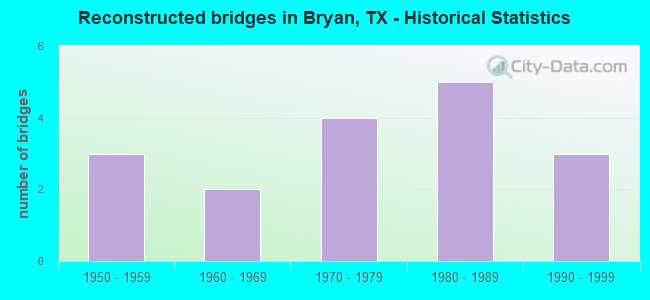
- Reconstructed bridges - Historical Statistics
- 31950-1959
- 21960-1969
- 41970-1979
- 51980-1989
- 31990-1999
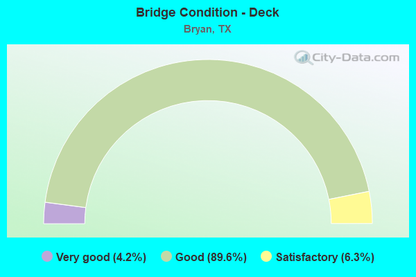
- Bridge Condition - Deck
- 4.2%Very good
- 89.6%Good
- 6.3%Satisfactory
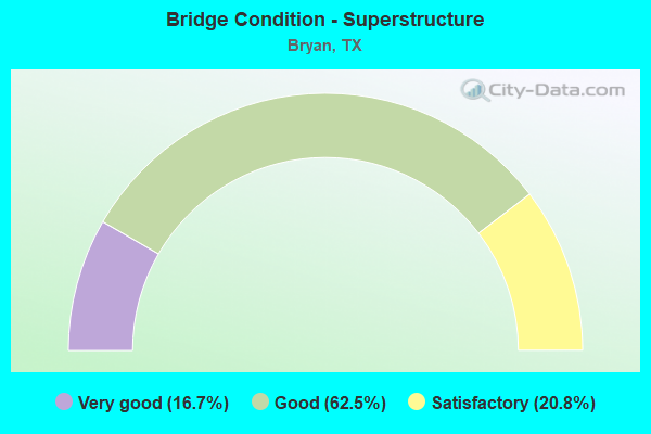
- Bridge Condition - Superstructure
- 16.7%Very good
- 62.5%Good
- 20.8%Satisfactory
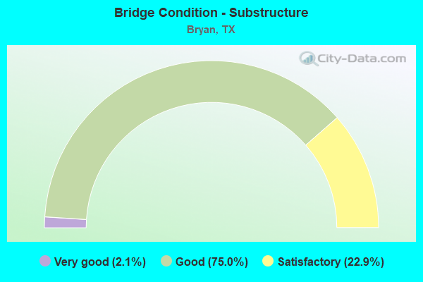
- Bridge Condition - Substructure
- 2.1%Very good
- 75.0%Good
- 22.9%Satisfactory
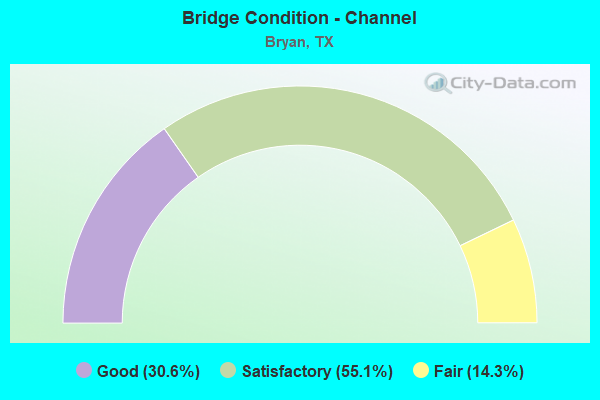
- Bridge Condition - Channel
- 30.6%Good
- 55.1%Satisfactory
- 14.3%Fair
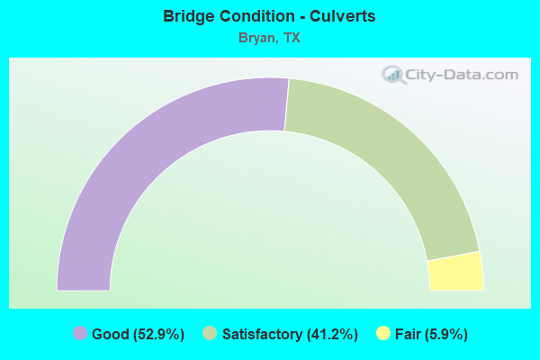
- Bridge Condition - Culverts
- 52.9%Good
- 41.2%Satisfactory
- 5.9%Fair
Find on map >> Show street view
Structure Number: 170210131601094, Location: 3.0 MI SE OF SH 21 (Lat: 30.630967, Lng: -96.376669), Route carried "on" structure: State highway 2818, Year Built: 2014, Status: Open, Structure Length: 8.23m (27.00ft), Average Daily Traffic: 18,490 (year 2013), Truck Traffic: 3%, Average Future Daily Traffic: 25,880 (year 2033), Design Load: HL 93, Features Intersected: FM 2818, Facility Carried by Structure: FM 1179
Minimum Vertical Clearance: 30+ m (98+ ft), Kilometerpoint: 14.275, Lanes on structure: 4, Lanes under structure: 8, Owner: State Highway Agency, Approaching Roadway Width: 26.2m (86.0ft), Skew: 30 degrees, Material/Design: Prestressed concrete, Design/Construction: Stringer/Multi-beam, Number Of Spans In Main Unit: 1, Number Of Approach Spans: 2, Length of Maximum Span: 42.7m (140.1ft), Curb-To-Curb Width: 24.9m (81.7ft), Out-to-Out Width: 26.2m (86.0ft)
Condition: Deck: Very good, Superstructure: Good, Substructure: Good, Operating Rating: 54.4 metric tons, Method Used To Determine Operating Rating: Assigned ratings based on Load and Resistance Factor Design (LRFD) reported in metric tons, Inventory Rating: 32.7 metric tons, Method Used To Determine Inventory Rating: Assigned ratings based on Load and Resistance Factor Design (LRFD) reported in metric tons, Structural Evaluation: Better than present minimum criteria, Deck Geometry: Superior to present desirable criteria, Underclear: Equal to present minimum criteria, Approach Roadway Alignment: Equal to present desirable criteria, Designated Inspection Frequency: Every 24 months, Inspection Date: Febuary 2021, Deck Structure Type: Concrete Precast Panels
Find on map >> Show street view
Structure Number: 170210156001007, Location: 0.4 MI NW OF SH 21 (Lat: 30.680042, Lng: -96.395775), Route carried "on" structure: State highway 1687, Year Built: 2005, Status: Open, Structure Length: 0.94m (3.08ft), Average Daily Traffic: 4,066 (year 2020), Truck Traffic: 10%, Average Future Daily Traffic: 5,000 (year 2033), Design Load: HS 20, Features Intersected: STILL CREEK
Minimum Vertical Clearance: 30+ m (98+ ft), Kilometerpoint: 1.659, Lanes on structure: 2, Owner: State Highway Agency, Approaching Roadway Width: 9.1m (29.9ft), Material/Design: Concrete, Design/Construction: Culvert, Number Of Spans In Main Unit: 3, Length of Maximum Span: 2.7m (8.9ft)
Condition: Channel: Satisfactory, Culverts: Fair, Operating Rating: 44.4 metric tons, Method Used To Determine Operating Rating: Assigned rating based on Load Factor Design (LFD) reported in metric tons, Inventory Rating: 32.7 metric tons, Method Used To Determine Inventory Rating: Assigned rating based on Load Factor Design (LFD) reported in metric tons, Structural Evaluation: Somewhat better than minimum adequacy, Waterway Adequacy: Equal to present minimum criteria, Approach Roadway Alignment: Equal to present desirable criteria, Designated Inspection Frequency: Every 24 months, Inspection Date: Febuary 2021
Find on map >> Show street view
Structure Number: 170210239901001, Location: 1.7 MI NW OF FM 60 (Lat: 30.623614, Lng: -96.377225), Route carried "on" structure: State highway 2818, Year Built: 1960, Year Reconstructed: 1969, Status: Open, Structure Length: 0.67m (2.20ft), Average Daily Traffic: 27,324 (year 2017), Truck Traffic: 3%, Average Future Daily Traffic: 25,880 (year 2033), Design Load: H 20, Features Intersected: TURKEY CREEK
Minimum Vertical Clearance: 30+ m (98+ ft), Kilometerpoint: 15.049, Lanes on structure: 5, Base Highway Network: Yes (Inventory Route: 28, Subroute: 1), Owner: State Highway Agency, Approaching Roadway Width: 20.7m (67.9ft), Material/Design: Concrete, Design/Construction: Culvert, Number Of Spans In Main Unit: 2, Length of Maximum Span: 3.0m (9.8ft)
Condition: Channel: Satisfactory, Culverts: Satisfactory, Operating Rating: 39.9 metric tons, Method Used To Determine Operating Rating: Load Factor (LF), Inventory Rating: 23.6 metric tons, Method Used To Determine Inventory Rating: Load Factor (LF), Structural Evaluation: Somewhat better than minimum adequacy, Waterway Adequacy: Equal to present minimum criteria, Approach Roadway Alignment: Equal to present desirable criteria, Designated Inspection Frequency: Every 24 months, Inspection Date: January 2021
Find on map >> Show street view
Structure Number: 170210285101001, Location: 0.7 MI SE OF SH 21 (Lat: 30.657881, Lng: -96.403511), Route carried "on" structure: State highway 2818, Year Built: 1964, Status: Open, Structure Length: 0.91m (2.99ft), Average Daily Traffic: 9,536 (year 2019), Truck Traffic: 3%, Average Future Daily Traffic: 9,790 (year 2033), Design Load: H 20, Features Intersected: COTTONWOOD BRANCH
Minimum Vertical Clearance: 30+ m (98+ ft), Kilometerpoint: 10.285, Lanes on structure: 3, Base Highway Network: Yes (Inventory Route: 28, Subroute: 1), Owner: State Highway Agency, Approaching Roadway Width: 11.0m (36.1ft), Material/Design: Concrete, Design/Construction: Culvert, Number Of Spans In Main Unit: 3, Length of Maximum Span: 2.7m (8.9ft), Curb-To-Curb Width: 16.0m (52.5ft), Out-to-Out Width: 21.1m (69.2ft)
Condition: Channel: Satisfactory, Culverts: Satisfactory, Operating Rating: 39.9 metric tons, Method Used To Determine Operating Rating: Load Factor (LF), Inventory Rating: 23.6 metric tons, Method Used To Determine Inventory Rating: Load Factor (LF), Structural Evaluation: Somewhat better than minimum adequacy, Deck Geometry: Better than present minimum criteria, Waterway Adequacy: Equal to present minimum criteria, Approach Roadway Alignment: Equal to present desirable criteria, Designated Inspection Frequency: Every 24 months, Inspection Date: January 2021, Deck Structure Type: Concrete Cast-file-Place, Wearing Surface/Protective System: Wearing Surface: Bituminous
Find on map >> Show street view
Structure Number: 170210285101002, Location: 0.5 MI S OF US 190 (Lat: 30.720539, Lng: -96.427594), Route carried "on" structure: State highway 2818, Year Built: 1975, Status: Open, Structure Length: 6.10m (20.01ft), Average Daily Traffic: 9,516 (year 2020), Truck Traffic: 4%, Average Future Daily Traffic: 9,520 (year 2033), Design Load: HS 20, Features Intersected: UP RR
Minimum Vertical Clearance: 30+ m (98+ ft), Kilometerpoint: 2.388, Lanes on structure: 2, Owner: State Highway Agency, Approaching Roadway Width: 12.2m (40.0ft), Skew: 2 degrees, Material/Design: Prestressed concrete, Design/Construction: Stringer/Multi-beam, Number Of Spans In Main Unit: 2, Number Of Approach Spans: 1, Length of Maximum Span: 24.4m (80.1ft), Curb-To-Curb Width: 12.5m (41.0ft), Out-to-Out Width: 13.5m (44.3ft)
Condition: Deck: Good, Superstructure: Very good, Substructure: Good, Operating Rating: 54.4 metric tons, Method Used To Determine Operating Rating: Assigned rating based on Load Factor Design (LFD) reported in metric tons, Inventory Rating: 32.7 metric tons, Method Used To Determine Inventory Rating: Assigned rating based on Load Factor Design (LFD) reported in metric tons, Structural Evaluation: Better than present minimum criteria, Deck Geometry: Somewhat better than minimum adequacy, Underclear: Equal to present minimum criteria, Approach Roadway Alignment: Equal to present desirable criteria, Designated Inspection Frequency: Every 24 months, Inspection Date: Febuary 2021, Deck Structure Type: Concrete Cast-file-Place
Find on map >> Show street view
Structure Number: 170210285101003, Location: 2.15 MI NW OF SH 21 (Lat: 30.693069, Lng: -96.429758), Route carried "on" structure: State highway 2818, Year Built: 1975, Status: Open, Structure Length: 2.38m (7.81ft), Average Daily Traffic: 6,229 (year 2020), Truck Traffic: 3%, Average Future Daily Traffic: 7,370 (year 2033), Design Load: HS 20, Features Intersected: THOMPSON BRANCH
Minimum Vertical Clearance: 30+ m (98+ ft), Kilometerpoint: 5.444, Lanes on structure: 2, Owner: State Highway Agency, Approaching Roadway Width: 11.9m (39.0ft), Skew: 1 degrees, Material/Design: Concrete, Design/Construction: Culvert, Number Of Spans In Main Unit: 7, Length of Maximum Span: 3.0m (9.8ft)
Condition: Channel: Satisfactory, Culverts: Satisfactory, Operating Rating: 39.9 metric tons, Method Used To Determine Operating Rating: Load Factor (LF), Inventory Rating: 23.6 metric tons, Method Used To Determine Inventory Rating: Load Factor (LF), Structural Evaluation: Somewhat better than minimum adequacy, Waterway Adequacy: Superior to present desirable criteria, Approach Roadway Alignment: Equal to present desirable criteria, Designated Inspection Frequency: Every 48 months, Inspection Date: Febuary 2019
Find on map >> Show street view
Structure Number: 170210285101004, Location: 0.6 MI NW OF SH 21 (Lat: 30.675469, Lng: -96.412708), Route carried "on" structure: State highway 2818, Year Built: 1975, Status: Open, Structure Length: 0.88m (2.89ft), Average Daily Traffic: 7,125 (year 2020), Truck Traffic: 3%, Average Future Daily Traffic: 8,310 (year 2033), Design Load: HS 20, Features Intersected: DRAW
Minimum Vertical Clearance: 30+ m (98+ ft), Kilometerpoint: 8.064, Lanes on structure: 2, Owner: State Highway Agency, Approaching Roadway Width: 11.6m (38.1ft), Skew: 4 degrees, Material/Design: Concrete, Design/Construction: Culvert, Number Of Spans In Main Unit: 3, Length of Maximum Span: 1.8m (5.9ft)
Condition: Channel: Satisfactory, Culverts: Good, Operating Rating: 39.9 metric tons, Method Used To Determine Operating Rating: Load Factor (LF), Inventory Rating: 23.6 metric tons, Method Used To Determine Inventory Rating: Load Factor (LF), Structural Evaluation: Somewhat better than minimum adequacy, Waterway Adequacy: Superior to present desirable criteria, Approach Roadway Alignment: Equal to present desirable criteria, Designated Inspection Frequency: Every 48 months, Inspection Date: Febuary 2019
Find on map >> Show street view
Structure Number: 170210285101005, Location: 0.3 MI NW OF SH 21 (Lat: 30.671883, Lng: -96.409356), Route carried "on" structure: State highway 2818, Year Built: 1975, Status: Open, Structure Length: 3.81m (12.50ft), Average Daily Traffic: 7,125 (year 2020), Truck Traffic: 3%, Average Future Daily Traffic: 4,150 (year 2033), Design Load: HS 20, Features Intersected: STILL CREEK
Minimum Vertical Clearance: 30+ m (98+ ft), Kilometerpoint: 8.573, Lanes on structure: 4, Owner: State Highway Agency, Approaching Roadway Width: 20.7m (67.9ft), Skew: 13 degrees, Material/Design: Concrete, Design/Construction: Culvert, Number Of Spans In Main Unit: 10, Length of Maximum Span: 3.0m (9.8ft)
Condition: Channel: Fair, Culverts: Fair, Operating Rating: 39.9 metric tons, Method Used To Determine Operating Rating: Load Factor (LF), Inventory Rating: 23.6 metric tons, Method Used To Determine Inventory Rating: Load Factor (LF), Structural Evaluation: Somewhat better than minimum adequacy, Waterway Adequacy: Superior to present desirable criteria, Approach Roadway Alignment: Equal to present desirable criteria, Designated Inspection Frequency: Every 24 months, Inspection Date: Febuary 2021
Find on map >> Show street view
Structure Number: 170210285101008, Location: 0.7 MI SE OF SH 21 (Lat: 30.658017, Lng: -96.403150), Route carried "on" structure: State highway 2818, Year Built: 1975, Status: Open, Structure Length: 1.19m (3.90ft), Average Daily Traffic: 9,526 (year 2019), Truck Traffic: 3%, Average Future Daily Traffic: 9,790 (year 2033), Design Load: HS 20, Features Intersected: COTTONWOOD BRANCH
Minimum Vertical Clearance: 30+ m (98+ ft), Kilometerpoint: 10.285, Lanes on structure: 2, Base Highway Network: Yes (Inventory Route: 28, Subroute: 1), Owner: State Highway Agency, Approaching Roadway Width: 11.6m (38.1ft), Material/Design: Concrete, Design/Construction: Culvert, Number Of Spans In Main Unit: 4, Length of Maximum Span: 2.7m (8.9ft)
Condition: Channel: Fair, Culverts: Satisfactory, Operating Rating: 39.9 metric tons, Method Used To Determine Operating Rating: Load Factor (LF), Inventory Rating: 23.6 metric tons, Method Used To Determine Inventory Rating: Load Factor (LF), Structural Evaluation: Somewhat better than minimum adequacy, Waterway Adequacy: Equal to present minimum criteria, Approach Roadway Alignment: Equal to present desirable criteria, Designated Inspection Frequency: Every 24 months, Inspection Date: January 2021
Find on map >> Show street view
Structure Number: 170210313802002, Location: 1.3 MI SE OF SH 21 (Lat: 30.637656, Lng: -96.452469), Route carried "on" structure: State highway 47, Year Built: 1996, Status: Open, Structure Length: 9.75m (31.99ft), Average Daily Traffic: 3,692 (year 2020), Truck Traffic: 11%, Average Future Daily Traffic: 4,720 (year 2033), Design Load: HS 20, Features Intersected: THOMPSON CREEK
Minimum Vertical Clearance: 30+ m (98+ ft), Kilometerpoint: 2.332, Lanes on structure: 2, Base Highway Network: Yes (Inventory Route: SH, Subroute: 1), Owner: State Highway Agency, Approaching Roadway Width: 11.6m (38.1ft), Material/Design: Concrete, Design/Construction: Stringer/Multi-beam, Number Of Spans In Main Unit: 8, Length of Maximum Span: 12.2m (40.0ft), Curb-To-Curb Width: 11.3m (37.1ft), Out-to-Out Width: 12.2m (40.0ft)
Condition: Deck: Good, Superstructure: Good, Substructure: Satisfactory, Channel: Satisfactory, Operating Rating: 49.9 metric tons, Method Used To Determine Operating Rating: Load Factor (LF), Inventory Rating: 29.9 metric tons, Method Used To Determine Inventory Rating: Load Factor (LF), Structural Evaluation: Equal to present minimum criteria, Deck Geometry: Equal to present minimum criteria, Waterway Adequacy: Equal to present minimum criteria, Approach Roadway Alignment: Equal to present desirable criteria, Designated Inspection Frequency: Every 24 months, Inspection Date: January 2021, Deck Structure Type: Concrete Cast-file-Place
Find on map >> Show street view
Structure Number: 170210313802003, Location: 1.3 MI SE OF SH 21 (Lat: 30.637911, Lng: -96.452278), Route carried "on" structure: State highway 47, Year Built: 1996, Status: Open, Structure Length: 9.75m (31.99ft), Average Daily Traffic: 3,957 (year 2020), Truck Traffic: 11%, Average Future Daily Traffic: 4,720 (year 2033), Design Load: HS 20, Features Intersected: THOMPSON CREEK
Minimum Vertical Clearance: 30+ m (98+ ft), Kilometerpoint: 2.332, Lanes on structure: 2, Base Highway Network: Yes (Inventory Route: SH, Subroute: 1), Owner: State Highway Agency, Approaching Roadway Width: 11.6m (38.1ft), Material/Design: Concrete, Design/Construction: Stringer/Multi-beam, Number Of Spans In Main Unit: 8, Length of Maximum Span: 12.2m (40.0ft), Curb-To-Curb Width: 11.4m (37.4ft), Out-to-Out Width: 12.2m (40.0ft)
Condition: Deck: Good, Superstructure: Good, Substructure: Good, Channel: Satisfactory, Operating Rating: 44.4 metric tons, Method Used To Determine Operating Rating: Load Factor (LF), Inventory Rating: 32.7 metric tons, Method Used To Determine Inventory Rating: Load Factor (LF), Structural Evaluation: Better than present minimum criteria, Deck Geometry: Equal to present minimum criteria, Waterway Adequacy: Equal to present minimum criteria, Approach Roadway Alignment: Equal to present desirable criteria, Designated Inspection Frequency: Every 24 months, Inspection Date: January 2021, Deck Structure Type: Concrete Cast-file-Place
Find on map >> Show street view
Structure Number: 170210313802004, Location: 2.1 MI NW OF FM 60 (Lat: 30.601997, Lng: -96.405464), Route carried "on" structure: State highway 47, Year Built: 1996, Status: Open, Structure Length: 3.90m (12.80ft), Average Daily Traffic: 3,850 (year 2013), Truck Traffic: 5%, Average Future Daily Traffic: 5,390 (year 2033), Design Load: HS 20, Features Intersected: TURKEY CREEK
Minimum Vertical Clearance: 30+ m (98+ ft), Kilometerpoint: 9.072, Lanes on structure: 2, Base Highway Network: Yes (Inventory Route: SH, Subroute: 1), Owner: State Highway Agency, Approaching Roadway Width: 11.0m (36.1ft), Skew: 2 degrees, Material/Design: Concrete, Design/Construction: Stringer/Multi-beam, Number Of Spans In Main Unit: 4, Length of Maximum Span: 9.8m (32.2ft), Curb-To-Curb Width: 12.2m (40.0ft), Out-to-Out Width: 13.0m (42.7ft)
Condition: Deck: Good, Superstructure: Good, Substructure: Good, Channel: Satisfactory, Operating Rating: 54.4 metric tons, Method Used To Determine Operating Rating: Load Factor (LF), Inventory Rating: 32.7 metric tons, Method Used To Determine Inventory Rating: Load Factor (LF), Structural Evaluation: Better than present minimum criteria, Deck Geometry: Better than present minimum criteria, Waterway Adequacy: Equal to present minimum criteria, Approach Roadway Alignment: Equal to present desirable criteria, Designated Inspection Frequency: Every 24 months, Inspection Date: January 2021, Deck Structure Type: Concrete Cast-file-Place
Find on map >> Show street view
Structure Number: 170210313802005, Location: 2.1 MI NW OF FM 60 (Lat: 30.602975, Lng: -96.405250), Route carried "on" structure: State highway 47, Year Built: 1996, Status: Open, Structure Length: 3.90m (12.80ft), Average Daily Traffic: 3,850 (year 2013), Truck Traffic: 5%, Average Future Daily Traffic: 5,390 (year 2033), Design Load: HS 20, Features Intersected: TURKEY CREEK
Minimum Vertical Clearance: 30+ m (98+ ft), Kilometerpoint: 8.335, Lanes on structure: 2, Base Highway Network: Yes (Inventory Route: SH, Subroute: 1), Owner: State Highway Agency, Approaching Roadway Width: 11.0m (36.1ft), Skew: 2 degrees, Material/Design: Concrete, Design/Construction: Stringer/Multi-beam, Number Of Spans In Main Unit: 4, Length of Maximum Span: 9.8m (32.2ft), Curb-To-Curb Width: 12.2m (40.0ft), Out-to-Out Width: 13.0m (42.7ft)
Condition: Deck: Good, Superstructure: Good, Substructure: Very good, Channel: Satisfactory, Operating Rating: 54.4 metric tons, Method Used To Determine Operating Rating: Load Factor (LF), Inventory Rating: 32.7 metric tons, Method Used To Determine Inventory Rating: Load Factor (LF), Structural Evaluation: Better than present minimum criteria, Deck Geometry: Better than present minimum criteria, Waterway Adequacy: Equal to present minimum criteria, Approach Roadway Alignment: Equal to present desirable criteria, Designated Inspection Frequency: Every 24 months, Inspection Date: January 2021, Deck Structure Type: Concrete Cast-file-Place
Find on map >> Show street view
Structure Number: 170210313802009, Location: 1.17 MI S OF FM 1688 (Lat: 30.606378, Lng: -96.409950), Route carried "on" structure: State highway 47, Year Built: 2008, Status: Open, Structure Length: 8.23m (27.00ft), Average Daily Traffic: 3,370 (year 2013), Truck Traffic: 11%, Average Future Daily Traffic: 4,720 (year 2033), Design Load: HS 20, Features Intersected: FM 1179
Minimum Vertical Clearance: 30+ m (98+ ft), Kilometerpoint: 7.667, Lanes on structure: 2, Lanes under structure: 2, Base Highway Network: Yes (Inventory Route: SH, Subroute: 1), Owner: State Highway Agency, Approaching Roadway Width: 11.6m (38.1ft), Material/Design: Prestressed concrete, Design/Construction: Box Beam or Girders - Multiple, Number Of Spans In Main Unit: 3, Length of Maximum Span: 27.4m (89.9ft), Curb-To-Curb Width: 11.4m (37.4ft), Out-to-Out Width: 12.2m (40.0ft)
Condition: Deck: Good, Superstructure: Very good, Substructure: Good, Operating Rating: 54.4 metric tons, Method Used To Determine Operating Rating: Assigned rating based on Load Factor Design (LFD) reported in metric tons, Inventory Rating: 32.7 metric tons, Method Used To Determine Inventory Rating: Assigned rating based on Load Factor Design (LFD) reported in metric tons, Structural Evaluation: Better than present minimum criteria, Deck Geometry: Equal to present minimum criteria, Underclear: Better than present minimum criteria, Approach Roadway Alignment: Equal to present desirable criteria, Designated Inspection Frequency: Every 24 months, Inspection Date: January 2021, Deck Structure Type: Concrete Cast-file-Place
Find on map >> Show street view
Structure Number: 17021031380201, Location: 1.17 MI S OF FM 1688 (Lat: 30.606658, Lng: -96.410917), Route carried "on" structure: State highway 47, Year Built: 2008, Status: Open, Structure Length: 8.23m (27.00ft), Average Daily Traffic: 3,370 (year 2013), Truck Traffic: 11%, Average Future Daily Traffic: 4,720 (year 2033), Design Load: HS 20, Features Intersected: FM 1179
Minimum Vertical Clearance: 30+ m (98+ ft), Kilometerpoint: 7.667, Lanes on structure: 2, Lanes under structure: 2, Base Highway Network: Yes (Inventory Route: SH, Subroute: 1), Owner: State Highway Agency, Approaching Roadway Width: 11.6m (38.1ft), Material/Design: Prestressed concrete, Design/Construction: Box Beam or Girders - Multiple, Number Of Spans In Main Unit: 3, Length of Maximum Span: 27.4m (89.9ft), Curb-To-Curb Width: 11.4m (37.4ft), Out-to-Out Width: 12.2m (40.0ft)
Condition: Deck: Good, Superstructure: Good, Substructure: Good, Operating Rating: 54.4 metric tons, Method Used To Determine Operating Rating: Assigned rating based on Load Factor Design (LFD) reported in metric tons, Inventory Rating: 32.7 metric tons, Method Used To Determine Inventory Rating: Assigned rating based on Load Factor Design (LFD) reported in metric tons, Structural Evaluation: Better than present minimum criteria, Deck Geometry: Equal to present minimum criteria, Underclear: Better than present minimum criteria, Approach Roadway Alignment: Equal to present desirable criteria, Designated Inspection Frequency: Every 24 months, Inspection Date: January 2021, Deck Structure Type: Concrete Cast-file-Place
Find on map >> Show street view
Structure Number: 170210313802011, Location: 0.4 MI NW OF FM 1688 (Lat: 30.623458, Lng: -96.430706), Route carried "on" structure: State highway 47, Year Built: 1996, Status: Open, Structure Length: 0.76m (2.49ft), Average Daily Traffic: 3,212 (year 2020), Truck Traffic: 11%, Average Future Daily Traffic: 4,720 (year 2033), Design Load: HS 20, Features Intersected: TRIB OF THOMPSON CREEK
Minimum Vertical Clearance: 30+ m (98+ ft), Kilometerpoint: 5.015, Lanes on structure: 2, Base Highway Network: Yes (Inventory Route: SH, Subroute: 1), Owner: State Highway Agency, Approaching Roadway Width: 11.6m (38.1ft), Skew: 4 degrees, Material/Design: Concrete, Design/Construction: Culvert, Number Of Spans In Main Unit: 2, Length of Maximum Span: 2.1m (6.9ft)
Condition: Channel: Satisfactory, Culverts: Satisfactory, Operating Rating: 39.9 metric tons, Method Used To Determine Operating Rating: Load Factor (LF), Inventory Rating: 23.6 metric tons, Method Used To Determine Inventory Rating: Load Factor (LF), Structural Evaluation: Equal to present minimum criteria, Waterway Adequacy: Equal to present minimum criteria, Approach Roadway Alignment: Equal to present desirable criteria, Designated Inspection Frequency: Every 48 months, Inspection Date: January 2019
Find on map >> Show street view
Structure Number: 170210313802012, Location: 0.3 MI NW OF FM 1688 (Lat: 30.622503, Lng: -96.430728), Route carried "on" structure: State highway 47, Year Built: 1996, Status: Open, Structure Length: 0.76m (2.49ft), Average Daily Traffic: 3,479 (year 2020), Truck Traffic: 11%, Average Future Daily Traffic: 4,720 (year 2033), Design Load: HS 20, Features Intersected: TRIB OF THOMPSON CREEK
Minimum Vertical Clearance: 30+ m (98+ ft), Kilometerpoint: 5.084, Lanes on structure: 2, Base Highway Network: Yes (Inventory Route: SH, Subroute: 1), Owner: State Highway Agency, Approaching Roadway Width: 11.6m (38.1ft), Skew: 4 degrees, Material/Design: Concrete, Design/Construction: Culvert, Number Of Spans In Main Unit: 2, Length of Maximum Span: 2.1m (6.9ft)
Condition: Channel: Satisfactory, Culverts: Good, Operating Rating: 39.9 metric tons, Method Used To Determine Operating Rating: Load Factor (LF), Inventory Rating: 23.6 metric tons, Method Used To Determine Inventory Rating: Load Factor (LF), Structural Evaluation: Equal to present minimum criteria, Waterway Adequacy: Equal to present minimum criteria, Approach Roadway Alignment: Equal to present desirable criteria, Designated Inspection Frequency: Every 48 months, Inspection Date: January 2019
Find on map >> Show street view
Structure Number: 170210313802014, Location: 0.4 MI NW OF FM 1688 (Lat: 30.621433, Lng: -96.429211), Route carried "on" structure: State highway 47, Year Built: 1996, Status: Open, Structure Length: 0.70m (2.30ft), Average Daily Traffic: 6,691 (year 2020), Truck Traffic: 11%, Average Future Daily Traffic: 9,450 (year 2033), Design Load: HS 20, Features Intersected: TRIB OF THOMPSON CREEK
Minimum Vertical Clearance: 30+ m (98+ ft), Kilometerpoint: 5.356, Lanes on structure: 4, Base Highway Network: Yes (Inventory Route: SH, Subroute: 1), Owner: State Highway Agency, Approaching Roadway Width: 20.7m (67.9ft), Skew: 21 degrees, Material/Design: Concrete, Design/Construction: Culvert, Number Of Spans In Main Unit: 2, Length of Maximum Span: 2.7m (8.9ft)
Condition: Channel: Fair, Culverts: Good, Operating Rating: 39.9 metric tons, Method Used To Determine Operating Rating: Load Factor (LF), Inventory Rating: 23.6 metric tons, Method Used To Determine Inventory Rating: Load Factor (LF), Structural Evaluation: Somewhat better than minimum adequacy, Waterway Adequacy: Equal to present desirable criteria, Approach Roadway Alignment: Equal to present desirable criteria, Designated Inspection Frequency: Every 24 months, Inspection Date: January 2021
Find on map >> Show street view
Structure Number: 170210313802053, Location: 2.4 MI E OF OSR (Lat: 30.649911, Lng: -96.467631), Route carried "on" structure: State highway 47, Year Built: 1996, Status: Open, Structure Length: 10.67m (35.01ft), Average Daily Traffic: 2,770 (year 2013), Truck Traffic: 14%, Average Future Daily Traffic: 3,870 (year 2033), Design Load: HS 20, Features Intersected: SH 21 EB
Minimum Vertical Clearance: 5.05m (16.57ft), Kilometerpoint: 0.402, Lanes on structure: 2, Lanes under structure: 2, Owner: State Highway Agency, Approaching Roadway Width: 11.0m (36.1ft), Material/Design: Prestressed concrete, Design/Construction: Stringer/Multi-beam, Number Of Spans In Main Unit: 3, Length of Maximum Span: 39.6m (129.9ft), Curb-To-Curb Width: 11.6m (38.1ft), Out-to-Out Width: 12.2m (40.0ft)
Condition: Deck: Good, Superstructure: Good, Substructure: Good, Operating Rating: 54.4 metric tons, Method Used To Determine Operating Rating: Assigned rating based on Load Factor Design (LFD) reported in metric tons, Inventory Rating: 32.7 metric tons, Method Used To Determine Inventory Rating: Assigned rating based on Load Factor Design (LFD) reported in metric tons, Structural Evaluation: Better than present minimum criteria, Deck Geometry: Better than present minimum criteria, Underclear: Superior to present desirable criteria, Approach Roadway Alignment: Equal to present desirable criteria, Designated Inspection Frequency: Every 24 months, Inspection Date: Febuary 2021, Deck Structure Type: Concrete Precast Panels
Find on map >> Show street view
Structure Number: 170210313802054, Location: 0.85 MI N OF FM 60 (Lat: 30.594303, Lng: -96.391236), Route carried "on" structure: State highway 47, Year Built: 2013, Status: Open, Structure Length: 9.14m (29.99ft), Average Daily Traffic: 7,700 (year 2013), Truck Traffic: 5%, Average Future Daily Traffic: 10,780 (year 2033), Design Load: HL 93, Features Intersected: HSC PARKWAY
Minimum Vertical Clearance: 30+ m (98+ ft), Kilometerpoint: 1.368, Lanes on structure: 2, Lanes under structure: 6, Owner: State Highway Agency, Approaching Roadway Width: 11.6m (38.1ft), Material/Design: Prestressed concrete, Design/Construction: Stringer/Multi-beam, Number Of Spans In Main Unit: 1, Number Of Approach Spans: 2, Length of Maximum Span: 36.6m (120.1ft), Curb-To-Curb Width: 11.7m (38.4ft), Out-to-Out Width: 12.2m (40.0ft)
Condition: Deck: Good, Superstructure: Very good, Substructure: Good, Operating Rating: 54.4 metric tons, Method Used To Determine Operating Rating: Assigned ratings based on Load and Resistance Factor Design (LRFD) reported in metric tons, Inventory Rating: 32.7 metric tons, Method Used To Determine Inventory Rating: Assigned ratings based on Load and Resistance Factor Design (LRFD) reported in metric tons, Structural Evaluation: Better than present minimum criteria, Deck Geometry: Somewhat better than minimum adequacy, Underclear: Superior to present desirable criteria, Approach Roadway Alignment: Equal to present desirable criteria, Designated Inspection Frequency: Every 24 months, Inspection Date: Febuary 2021, Deck Structure Type: Concrete Precast Panels
Find on map >> Show street view
Structure Number: 170210313802055, Location: 0.85 MI N OF FM 60 (Lat: 30.594558, Lng: -96.391064), Route carried "on" structure: State highway 47, Year Built: 2013, Status: Open, Structure Length: 9.14m (29.99ft), Average Daily Traffic: 3,850 (year 2013), Truck Traffic: 5%, Average Future Daily Traffic: 5,390 (year 2033), Design Load: HL 93, Features Intersected: HSC PARKWAY
Minimum Vertical Clearance: 30+ m (98+ ft), Kilometerpoint: 1.368, Lanes on structure: 2, Lanes under structure: 6, Owner: State Highway Agency, Approaching Roadway Width: 11.6m (38.1ft), Material/Design: Prestressed concrete, Design/Construction: Stringer/Multi-beam, Number Of Spans In Main Unit: 1, Number Of Approach Spans: 2, Length of Maximum Span: 36.6m (120.1ft), Curb-To-Curb Width: 11.7m (38.4ft), Out-to-Out Width: 12.2m (40.0ft)
Condition: Deck: Good, Superstructure: Very good, Substructure: Good, Operating Rating: 54.4 metric tons, Method Used To Determine Operating Rating: Assigned ratings based on Load and Resistance Factor Design (LRFD) reported in metric tons, Inventory Rating: 32.7 metric tons, Method Used To Determine Inventory Rating: Assigned ratings based on Load and Resistance Factor Design (LRFD) reported in metric tons, Structural Evaluation: Better than present minimum criteria, Deck Geometry: Better than present minimum criteria, Underclear: Superior to present desirable criteria, Approach Roadway Alignment: Equal to present desirable criteria, Designated Inspection Frequency: Every 24 months, Inspection Date: Febuary 2021, Deck Structure Type: Concrete Precast Panels
Find on map >> Show street view
Structure Number: 170210AA0101004, Location: 1.53 MI SE OF OSR (Lat: 30.755594, Lng: -96.422025), Route carried "on" structure: County highway , Year Built: 2009, Status: Open, Structure Length: 0.70m (2.30ft), Average Daily Traffic: 100 (year 2018), Average Future Daily Traffic: 150 (year 2038), Features Intersected: THOMPSON CREEK, Facility Carried by Structure: RABBIT LN
Minimum Vertical Clearance: 30+ m (98+ ft), Kilometerpoint: 2.462, Lanes on structure: 2, Owner: County Highway Agency, Approaching Roadway Width: 7.3m (24.0ft), Skew: 3 degrees, Material/Design: Steel, Design/Construction: Culvert, Number Of Spans In Main Unit: 3, Length of Maximum Span: 1.8m (5.9ft)
Condition: Channel: Satisfactory, Culverts: Satisfactory, Operating Rating: 32.7 metric tons, Method Used To Determine Operating Rating: Field evaluation and documented engineering judgment, Inventory Rating: 24.5 metric tons, Method Used To Determine Inventory Rating: Field evaluation and documented engineering judgment, Structural Evaluation: Equal to present minimum criteria, Waterway Adequacy: Meets minimum limits, Approach Roadway Alignment: Equal to present desirable criteria, Designated Inspection Frequency: Every 24 months, Inspection Date: November 2021
Find on map >> Show street view
Structure Number: 170210AA0101006, Location: 3.36 MI SE OF OSR (Lat: 30.737178, Lng: -96.399961), Route carried "on" structure: County highway , Year Built: 2015, Status: Open, Structure Length: 0.64m (2.10ft), Average Daily Traffic: 100 (year 2018), Average Future Daily Traffic: 150 (year 2038), Features Intersected: THOMPSONS BRANCH, Facility Carried by Structure: RABBIT LN
Minimum Vertical Clearance: 30+ m (98+ ft), Kilometerpoint: 5.407, Lanes on structure: 2, Owner: County Highway Agency, Approaching Roadway Width: 8.3m (27.2ft), Material/Design: Steel, Design/Construction: Culvert, Number Of Spans In Main Unit: 3, Length of Maximum Span: 1.5m (4.9ft)
Condition: Channel: Satisfactory, Culverts: Good, Operating Rating: 32.7 metric tons, Method Used To Determine Operating Rating: Field evaluation and documented engineering judgment, Inventory Rating: 24.5 metric tons, Method Used To Determine Inventory Rating: Field evaluation and documented engineering judgment, Structural Evaluation: Equal to present minimum criteria, Waterway Adequacy: Meets minimum limits, Approach Roadway Alignment: Equal to present desirable criteria, Designated Inspection Frequency: Every 24 months, Inspection Date: November 2021
Find on map >> Show street view
Structure Number: 170210AA0139004, Location: 1.80 MI NE OF FM 974 (Lat: 30.739606, Lng: -96.342572), Route carried "on" structure: County highway , Year Built: 1984, Status: Open, Structure Length: 0.82m (2.69ft), Average Daily Traffic: 1,000 (year 2018), Average Future Daily Traffic: 1,500 (year 2038), Features Intersected: LITTLE WICKSON CREEK, Facility Carried by Structure: DILLY SHAW TAP RD
Minimum Vertical Clearance: 30+ m (98+ ft), Kilometerpoint: 7.805, Lanes on structure: 2, Owner: County Highway Agency, Approaching Roadway Width: 7.9m (25.9ft), Material/Design: Concrete, Design/Construction: Culvert, Number Of Spans In Main Unit: 3, Length of Maximum Span: 2.4m (7.9ft)
Condition: Channel: Satisfactory, Culverts: Satisfactory, Operating Rating: 32.7 metric tons, Method Used To Determine Operating Rating: Field evaluation and documented engineering judgment, Inventory Rating: 24.5 metric tons, Method Used To Determine Inventory Rating: Field evaluation and documented engineering judgment, Structural Evaluation: Equal to present minimum criteria, Waterway Adequacy: High priority of corrective action, Approach Roadway Alignment: Equal to present desirable criteria, Designated Inspection Frequency: Every 24 months, Inspection Date: November 2021
Find on map >> Show street view
Structure Number: 170210AA0140002, Location: 0.27 MI NE OF FM 974 (Lat: 30.742708, Lng: -96.362908), Route carried "on" structure: County highway , Year Built: 2009, Status: Open, Structure Length: 1.22m (4.00ft), Average Daily Traffic: 60 (year 2018), Average Future Daily Traffic: 90 (year 2038), Design Load: HS 20, Features Intersected: LITTLE WICKSON CREEK, Facility Carried by Structure: WILCOX LN
Minimum Vertical Clearance: 30+ m (98+ ft), Kilometerpoint: 0.435, Lanes on structure: 2, Owner: County Highway Agency, Approaching Roadway Width: 8.5m (27.9ft), Material/Design: Steel, Design/Construction: Stringer/Multi-beam, Number Of Spans In Main Unit: 1, Length of Maximum Span: 11.3m (37.1ft), Curb-To-Curb Width: 8.5m (27.9ft), Out-to-Out Width: 8.6m (28.2ft)
Condition: Deck: Good, Superstructure: Satisfactory, Substructure: Good, Channel: Good, Operating Rating: 68.0 metric tons, Method Used To Determine Operating Rating: Load Factor (LF), Inventory Rating: 40.8 metric tons, Method Used To Determine Inventory Rating: Load Factor (LF), Structural Evaluation: Equal to present minimum criteria, Deck Geometry: Better than present minimum criteria, Waterway Adequacy: Better than present minimum criteria, Approach Roadway Alignment: Equal to present desirable criteria, Designated Inspection Frequency: Every 24 months, Inspection Date: November 2021, Deck Structure Type: Concrete Cast-file-Place
Find on map >> Show street view
Structure Number: 170210AA0165002, Location: 4.15 MI NE OF SH 30 (Lat: 30.688211, Lng: -96.221753), Route carried "on" structure: County highway , Year Built: 2003, Status: Open, Structure Length: 1.68m (5.51ft), Average Daily Traffic: 500 (year 2018), Average Future Daily Traffic: 1,000 (year 2038), Design Load: HS 20, Features Intersected: WICKSON CREEK, Facility Carried by Structure: ELMO WEEDON RD
Minimum Vertical Clearance: 30+ m (98+ ft), Kilometerpoint: 6.679, Lanes on structure: 2, Owner: County Highway Agency, Approaching Roadway Width: 7.9m (25.9ft), Skew: 1 degrees, Material/Design: Prestressed concrete, Design/Construction: Box Beam or Girders - Multiple, Number Of Spans In Main Unit: 1, Length of Maximum Span: 16.2m (53.1ft), Curb-To-Curb Width: 9.1m (29.9ft), Out-to-Out Width: 9.8m (32.2ft)
Condition: Deck: Good, Superstructure: Good, Substructure: Good, Channel: Satisfactory, Operating Rating: 54.4 metric tons, Method Used To Determine Operating Rating: Assigned rating based on Load Factor Design (LFD) reported in metric tons, Inventory Rating: 32.7 metric tons, Method Used To Determine Inventory Rating: Assigned rating based on Load Factor Design (LFD) reported in metric tons, Structural Evaluation: Better than present minimum criteria, Deck Geometry: Equal to present minimum criteria, Waterway Adequacy: High priority of corrective action, Approach Roadway Alignment: Equal to present desirable criteria, Designated Inspection Frequency: Every 24 months, Inspection Date: September 2021, Deck Structure Type: Concrete Cast-file-Place
Find on map >> Show street view
Structure Number: 170210AA0169005, Location: 4.50 MI SW OF FM 2038 (Lat: 30.721894, Lng: -96.300494), Route carried "on" structure: County highway , Year Built: 1998, Status: Open, Structure Length: 1.46m (4.79ft), Average Daily Traffic: 390 (year 2018), Average Future Daily Traffic: 500 (year 2038), Design Load: HS 20, Features Intersected: WICKSON CREEK TRIB, Facility Carried by Structure: OLD RELIANCE RD
Minimum Vertical Clearance: 30+ m (98+ ft), Kilometerpoint: 7.239, Lanes on structure: 2, Owner: County Highway Agency, Approaching Roadway Width: 7.3m (24.0ft), Skew: 1 degrees, Material/Design: Steel, Design/Construction: Stringer/Multi-beam, Number Of Spans In Main Unit: 1, Length of Maximum Span: 13.7m (44.9ft), Curb-To-Curb Width: 8.4m (27.6ft), Out-to-Out Width: 8.6m (28.2ft)
Condition: Deck: Good, Superstructure: Satisfactory, Substructure: Good, Channel: Good, Operating Rating: 44.4 metric tons, Method Used To Determine Operating Rating: Load Factor (LF), Inventory Rating: 32.7 metric tons, Method Used To Determine Inventory Rating: Load Factor (LF), Structural Evaluation: Equal to present minimum criteria, Deck Geometry: Somewhat better than minimum adequacy, Waterway Adequacy: Meets minimum limits, Approach Roadway Alignment: Somewhat better than minimum adequacy, Designated Inspection Frequency: Every 24 months, Inspection Date: September 2021, Deck Structure Type: Concrete Cast-file-Place
Find on map >> Show street view
Structure Number: 170210AA0176001, Location: 1.25 MI NE OF SH 30 (Lat: 30.662533, Lng: -96.247575), Route carried "on" structure: County highway , Year Built: 1992, Status: Open, Structure Length: 1.01m (3.31ft), Average Daily Traffic: 1,150 (year 2018), Average Future Daily Traffic: 1,600 (year 2038), Design Load: HS 20, Features Intersected: BRUSHY CREEK RELIEF, Facility Carried by Structure: HARDY WEEDON RD
Minimum Vertical Clearance: 30+ m (98+ ft), Kilometerpoint: 1.046, Lanes on structure: 2, Owner: County Highway Agency, Approaching Roadway Width: 7.3m (24.0ft), Material/Design: Concrete, Design/Construction: Culvert, Number Of Spans In Main Unit: 3, Length of Maximum Span: 3.0m (9.8ft), Curb-To-Curb Width: 9.1m (29.9ft), Out-to-Out Width: 10.8m (35.4ft)
Condition: Channel: Good, Culverts: Good, Operating Rating: 39.9 metric tons, Method Used To Determine Operating Rating: Load Factor (LF), Inventory Rating: 23.6 metric tons, Method Used To Determine Inventory Rating: Load Factor (LF), Structural Evaluation: Equal to present minimum criteria, Deck Geometry: Somewhat better than minimum adequacy, Waterway Adequacy: Better than present minimum criteria, Approach Roadway Alignment: Meets minimum limits, Designated Inspection Frequency: Every 24 months, Inspection Date: September 2021, Deck Structure Type: Concrete Cast-file-Place, Wearing Surface/Protective System: Wearing Surface: Bituminous
Find on map >> Show street view
Structure Number: 170210AA0176002, Location: 1.20 MI NE OF SH 30 (Lat: 30.661594, Lng: -96.248058), Route carried "on" structure: County highway , Year Built: 1992, Status: Open, Structure Length: 1.01m (3.31ft), Average Daily Traffic: 1,150 (year 2018), Average Future Daily Traffic: 1,600 (year 2038), Design Load: HS 20, Features Intersected: BRUSHY CREEK, Facility Carried by Structure: HARDY WEEDON RD
Minimum Vertical Clearance: 30+ m (98+ ft), Kilometerpoint: 1.127, Lanes on structure: 2, Owner: County Highway Agency, Approaching Roadway Width: 7.3m (24.0ft), Material/Design: Concrete, Design/Construction: Culvert, Number Of Spans In Main Unit: 3, Length of Maximum Span: 3.0m (9.8ft), Out-to-Out Width: 13.2m (43.3ft)
Condition: Channel: Satisfactory, Culverts: Good, Operating Rating: 39.9 metric tons, Method Used To Determine Operating Rating: Load Factor (LF), Inventory Rating: 23.6 metric tons, Method Used To Determine Inventory Rating: Load Factor (LF), Structural Evaluation: Equal to present minimum criteria, Waterway Adequacy: Better than present minimum criteria, Approach Roadway Alignment: Meets minimum limits, Designated Inspection Frequency: Every 24 months, Inspection Date: September 2021
Find on map >> Show street view
Structure Number: 170210AA0270001, Location: 1.50 MI NW OF FM 60 (Lat: 30.596336, Lng: -96.407547), Route carried "on" structure: County highway , Year Built: 1983, Status: Open, Structure Length: 3.69m (12.11ft), Average Daily Traffic: 832 (year 2017), Truck Traffic: 1%, Average Future Daily Traffic: 400 (year 2035), Design Load: HS 20, Features Intersected: TURKEY CREEK, Facility Carried by Structure: JONES RD
Minimum Vertical Clearance: 30+ m (98+ ft), Kilometerpoint: 2.414, Lanes on structure: 2, Owner: County Highway Agency, Approaching Roadway Width: 6.7m (22.0ft), Material/Design: Concrete, Design/Construction: Stringer/Multi-beam, Number Of Spans In Main Unit: 4, Length of Maximum Span: 9.1m (29.9ft), Curb-To-Curb Width: 8.5m (27.9ft), Out-to-Out Width: 9.2m (30.2ft)
Condition: Deck: Good, Superstructure: Good, Substructure: Satisfactory, Channel: Fair, Operating Rating: 54.4 metric tons, Method Used To Determine Operating Rating: Load Factor (LF), Inventory Rating: 32.7 metric tons, Method Used To Determine Inventory Rating: Load Factor (LF), Structural Evaluation: Equal to present minimum criteria, Deck Geometry: Somewhat better than minimum adequacy, Waterway Adequacy: Superior to present desirable criteria, Approach Roadway Alignment: Equal to present desirable criteria, Designated Inspection Frequency: Every 24 months, Inspection Date: September 2021, Deck Structure Type: Concrete Cast-file-Place
Find on map >> Show street view
Structure Number: 170210AA0274002, Location: 1.55 MI SW OF SH 47 (Lat: 30.601250, Lng: -96.443658), Route carried "on" structure: County highway , Year Built: 2010, Status: Open, Structure Length: 5.03m (16.50ft), Average Daily Traffic: 150 (year 2015), Truck Traffic: 2%, Average Future Daily Traffic: 200 (year 2035), Design Load: HL 93, Features Intersected: THOMPSON CREEK, Facility Carried by Structure: LEONARD RD
Minimum Vertical Clearance: 30+ m (98+ ft), Kilometerpoint: 2.494, Lanes on structure: 2, Owner: County Highway Agency, Approaching Roadway Width: 6.7m (22.0ft), Material/Design: Prestressed concrete, Design/Construction: Stringer/Multi-beam, Number Of Spans In Main Unit: 1, Number Of Approach Spans: 2, Length of Maximum Span: 22.9m (75.1ft), Curb-To-Curb Width: 7.3m (24.0ft), Out-to-Out Width: 7.9m (25.9ft)
Condition: Deck: Good, Superstructure: Very good, Substructure: Good, Channel: Satisfactory, Operating Rating: 54.4 metric tons, Method Used To Determine Operating Rating: Assigned ratings based on Load and Resistance Factor Design (LRFD) reported in metric tons, Inventory Rating: 32.7 metric tons, Method Used To Determine Inventory Rating: Assigned ratings based on Load and Resistance Factor Design (LRFD) reported in metric tons, Structural Evaluation: Better than present minimum criteria, Deck Geometry: Somewhat better than minimum adequacy, Waterway Adequacy: Better than present minimum criteria, Approach Roadway Alignment: Somewhat better than minimum adequacy, Designated Inspection Frequency: Every 24 months, Inspection Date: September 2021, Deck Structure Type: Concrete Precast Panels
Find on map >> Show street view
Structure Number: 170210AA0276001, Location: 0.40 MI NE OF SH 47 (Lat: 30.643875, Lng: -96.451783), Route carried "on" structure: County highway , Year Built: 2006, Status: Open, Structure Length: 3.35m (10.99ft), Average Daily Traffic: 120 (year 2018), Average Future Daily Traffic: 150 (year 2038), Design Load: HS 20, Features Intersected: THOMPSON CREEK, Facility Carried by Structure: SILVER HILL RD
Minimum Vertical Clearance: 30+ m (98+ ft), Kilometerpoint: 0.644, Lanes on structure: 2, Owner: County Highway Agency, Approaching Roadway Width: 7.3m (24.0ft), Material/Design: Steel, Design/Construction: Stringer/Multi-beam, Number Of Spans In Main Unit: 1, Number Of Approach Spans: 2, Length of Maximum Span: 18.3m (60.0ft), Curb-To-Curb Width: 8.5m (27.9ft), Out-to-Out Width: 8.6m (28.2ft)
Condition: Deck: Good, Superstructure: Satisfactory, Substructure: Satisfactory, Channel: Satisfactory, Operating Rating: 44.4 metric tons, Method Used To Determine Operating Rating: Load Factor (LF), Inventory Rating: 32.7 metric tons, Method Used To Determine Inventory Rating: Load Factor (LF), Structural Evaluation: Equal to present minimum criteria, Deck Geometry: Equal to present minimum criteria, Waterway Adequacy: Better than present minimum criteria, Approach Roadway Alignment: Somewhat better than minimum adequacy, Designated Inspection Frequency: Every 24 months, Inspection Date: September 2021, Deck Structure Type: Concrete Cast-file-Place
Find on map >> Show street view
Structure Number: 170210AA0283001, Location: 0.65 MI NW OF SH 21 (Lat: 30.661311, Lng: -96.435139), Route carried "on" structure: County highway , Year Built: 2009, Status: Open, Structure Length: 2.29m (7.51ft), Average Daily Traffic: 190 (year 2018), Average Future Daily Traffic: 240 (year 2038), Design Load: HS 20, Features Intersected: STILL CREEK, Facility Carried by Structure: PLEASANT HILL RD
Minimum Vertical Clearance: 30+ m (98+ ft), Kilometerpoint: 1.046, Lanes on structure: 2, Owner: County Highway Agency, Approaching Roadway Width: 7.9m (25.9ft), Material/Design: Steel, Design/Construction: Stringer/Multi-beam, Number Of Spans In Main Unit: 1, Length of Maximum Span: 21.9m (71.9ft), Curb-To-Curb Width: 8.4m (27.6ft), Out-to-Out Width: 8.5m (27.9ft)
Condition: Deck: Good, Superstructure: Satisfactory, Substructure: Good, Channel: Satisfactory, Operating Rating: 54.4 metric tons, Method Used To Determine Operating Rating: Assigned rating based on Load Factor Design (LFD) reported in metric tons, Inventory Rating: 32.7 metric tons, Method Used To Determine Inventory Rating: Assigned rating based on Load Factor Design (LFD) reported in metric tons, Structural Evaluation: Equal to present minimum criteria, Deck Geometry: Somewhat better than minimum adequacy, Waterway Adequacy: Equal to present minimum criteria, Approach Roadway Alignment: Equal to present desirable criteria, Length Of Structure Improvement: 1.22m (4.00ft), Designated Inspection Frequency: Every 24 months, Inspection Date: September 2021, Bridge Improvement Cost: $2,000, Roadway Improvement Cost: $1,000, Total Project Cost: $3,000, Deck Structure Type: Concrete Cast-file-Place
Find on map >> Show street view
Structure Number: 170210AA0302003, Location: 0.50 MI NW OF SH 21 (Lat: 30.685231, Lng: -96.392861), Route carried "on" structure: County highway , Year Built: 1992, Status: Open, Structure Length: 1.16m (3.81ft), Average Daily Traffic: 130 (year 2018), Average Future Daily Traffic: 180 (year 2038), Design Load: HS 20, Features Intersected: STILL CREEK, Facility Carried by Structure: MUMFORD RD
Minimum Vertical Clearance: 30+ m (98+ ft), Kilometerpoint: 0.381, Lanes on structure: 2, Owner: County Highway Agency, Approaching Roadway Width: 7.3m (24.0ft), Material/Design: Concrete, Design/Construction: Culvert, Number Of Spans In Main Unit: 4, Length of Maximum Span: 2.7m (8.9ft), Curb-To-Curb Width: 8.4m (27.6ft), Out-to-Out Width: 9.1m (29.9ft)
Condition: Channel: Satisfactory, Culverts: Good, Operating Rating: 39.9 metric tons, Method Used To Determine Operating Rating: Load Factor (LF), Inventory Rating: 23.6 metric tons, Method Used To Determine Inventory Rating: Load Factor (LF), Structural Evaluation: Equal to present minimum criteria, Deck Geometry: Somewhat better than minimum adequacy, Waterway Adequacy: Better than present minimum criteria, Approach Roadway Alignment: Equal to present desirable criteria, Designated Inspection Frequency: Every 24 months, Inspection Date: September 2021, Deck Structure Type: Concrete Cast-file-Place, Wearing Surface/Protective System: Wearing Surface: Bituminous
Find on map >> Show street view
Structure Number: 170210B00023001, Location: 0.05 MI NE OF TEXAS AVE (Lat: 30.703472, Lng: -96.391578), Route carried "on" structure: City street , Year Built: 1995, Status: Open, Structure Length: 0.65m (2.13ft), Average Daily Traffic: 1,000 (year 2018), Average Future Daily Traffic: 1,500 (year 2038), Features Intersected: STILL CREEK BRANCH, Facility Carried by Structure: STEVENS DR
Minimum Vertical Clearance: 30+ m (98+ ft), Kilometerpoint: 0.080, Lanes on structure: 2, Owner: City or Municipal Highway Agency, Approaching Roadway Width: 6.5m (21.3ft), Material/Design: Concrete, Design/Construction: Culvert, Number Of Spans In Main Unit: 2, Length of Maximum Span: 2.7m (8.9ft), Curb-To-Curb Width: 10.6m (34.8ft), Out-to-Out Width: 11.0m (36.1ft)
Condition: Channel: Satisfactory, Culverts: Good, Operating Rating: 32.7 metric tons, Method Used To Determine Operating Rating: Field evaluation and documented engineering judgment, Inventory Rating: 24.5 metric tons, Method Used To Determine Inventory Rating: Field evaluation and documented engineering judgment, Structural Evaluation: Equal to present minimum criteria, Deck Geometry: Equal to present minimum criteria, Waterway Adequacy: Better than present minimum criteria, Approach Roadway Alignment: Equal to present desirable criteria, Designated Inspection Frequency: Every 24 months, Inspection Date: September 2021, Deck Structure Type: Concrete Cast-file-Place, Wearing Surface/Protective System: Wearing Surface: Bituminous
Find on map >> Show street view
Structure Number: 170210B00027001, Location: 0.10 MI NE OF RUSSEL DR (Lat: 30.699522, Lng: -96.384931), Route carried "on" structure: City street , Year Built: 1993, Status: Open, Structure Length: 0.98m (3.22ft), Average Daily Traffic: 1,000 (year 2018), Average Future Daily Traffic: 1,500 (year 2038), Features Intersected: STILL CREEK, Facility Carried by Structure: TENNESSEE AVE
Minimum Vertical Clearance: 30+ m (98+ ft), Kilometerpoint: 0.161, Lanes on structure: 2, Owner: City or Municipal Highway Agency, Approaching Roadway Width: 8.5m (27.9ft), Material/Design: Concrete, Design/Construction: Culvert, Number Of Spans In Main Unit: 3, Length of Maximum Span: 3.0m (9.8ft), Curb or Sidewalk Widths: Left: 2.3m (7.5ft), Right: 2.3m (7.5ft), Curb-To-Curb Width: 8.5m (27.9ft), Out-to-Out Width: 13.7m (44.9ft)
Condition: Channel: Satisfactory, Culverts: Satisfactory, Operating Rating: 32.7 metric tons, Method Used To Determine Operating Rating: Field evaluation and documented engineering judgment, Inventory Rating: 24.5 metric tons, Method Used To Determine Inventory Rating: Field evaluation and documented engineering judgment, Structural Evaluation: Equal to present minimum criteria, Deck Geometry: Somewhat better than minimum adequacy, Waterway Adequacy: Meets minimum limits, Approach Roadway Alignment: Somewhat better than minimum adequacy, Designated Inspection Frequency: Every 24 months, Inspection Date: September 2021, Deck Structure Type: Concrete Cast-file-Place, Wearing Surface/Protective System: Wearing Surface: Bituminous
Find on map >> Show street view
Structure Number: 170210B00076002, Location: 3.10 MI NW OF SH 21 (Lat: 30.711047, Lng: -96.421033), Route carried "on" structure: City street , Year Built: 1990, Status: Open, Structure Length: 1.89m (6.20ft), Average Daily Traffic: 550 (year 2018), Truck Traffic: 5%, Average Future Daily Traffic: 600 (year 2038), Features Intersected: THOMPSON BRANCH, Facility Carried by Structure: MUMFORD RD
Minimum Vertical Clearance: 30+ m (98+ ft), Kilometerpoint: 2.258, Lanes on structure: 2, Owner: City or Municipal Highway Agency, Approaching Roadway Width: 6.7m (22.0ft), Skew: 3 degrees, Material/Design: Concrete, Design/Construction: Culvert, Number Of Spans In Main Unit: 5, Length of Maximum Span: 3.0m (9.8ft)
Condition: Channel: Good, Culverts: Satisfactory, Operating Rating: 32.7 metric tons, Method Used To Determine Operating Rating: Field evaluation and documented engineering judgment, Inventory Rating: 24.5 metric tons, Method Used To Determine Inventory Rating: Field evaluation and documented engineering judgment, Structural Evaluation: Equal to present minimum criteria, Waterway Adequacy: Better than present minimum criteria, Approach Roadway Alignment: Equal to present desirable criteria, Designated Inspection Frequency: Every 24 months, Inspection Date: November 2021
Find on map >> Show street view
Structure Number: 170210B00098001, Location: 0.35 MI NW of SH 21 (Lat: 30.683083, Lng: -96.390611), Route carried "on" structure: City street , Year Built: 1992, Status: Open, Structure Length: 0.89m (2.92ft), Average Daily Traffic: 400 (year 2015), Truck Traffic: 10%, Average Future Daily Traffic: 450 (year 2035), Features Intersected: STILL CREEK TRIBUTARY, Facility Carried by Structure: SAUNDERS ST
Minimum Vertical Clearance: 30+ m (98+ ft), Kilometerpoint: 0.163, Lanes on structure: 2, Owner: City or Municipal Highway Agency, Maintenance Responsibility: County Highway Agency, Approaching Roadway Width: 6.9m (22.6ft), Material/Design: Concrete, Design/Construction: Culvert, Number Of Spans In Main Unit: 3, Length of Maximum Span: 2.7m (8.9ft), Curb-To-Curb Width: 6.9m (22.6ft), Out-to-Out Width: 17.5m (57.4ft)
Condition: Channel: Good, Culverts: Good, Operating Rating: 32.7 metric tons, Method Used To Determine Operating Rating: Field evaluation and documented engineering judgment, Inventory Rating: 24.5 metric tons, Method Used To Determine Inventory Rating: Field evaluation and documented engineering judgment, Structural Evaluation: Equal to present minimum criteria, Deck Geometry: Meets minimum limits, Waterway Adequacy: Better than present minimum criteria, Approach Roadway Alignment: Equal to present desirable criteria, Designated Inspection Frequency: Every 24 months, Inspection Date: September 2021, Deck Structure Type: Concrete Cast-file-Place, Wearing Surface/Protective System: Wearing Surface: Bituminous
Find on map >> Show street view
Structure Number: 170210B00100001, Location: 0.2 MI SW OF MLK JR ST (Lat: 30.682364, Lng: -96.386036), Route carried "on" structure: City street , Year Built: 1965, Status: Open, Structure Length: 0.82m (2.69ft), Average Daily Traffic: 450 (year 2015), Average Future Daily Traffic: 500 (year 2035), Features Intersected: DRAIN, Facility Carried by Structure: DEAN ST
Minimum Vertical Clearance: 30+ m (98+ ft), Kilometerpoint: 0.323, Lanes on structure: 2, Owner: City or Municipal Highway Agency, Approaching Roadway Width: 9.8m (32.2ft), Material/Design: Concrete, Design/Construction: Culvert, Number Of Spans In Main Unit: 3, Length of Maximum Span: 2.4m (7.9ft), Curb or Sidewalk Widths: Left: 1.4m (4.6ft), Right: 1.4m (4.6ft), Curb-To-Curb Width: 9.7m (31.8ft), Out-to-Out Width: 12.9m (42.3ft)
Condition: Channel: Good, Culverts: Satisfactory, Operating Rating: 32.7 metric tons, Method Used To Determine Operating Rating: Field evaluation and documented engineering judgment, Inventory Rating: 24.5 metric tons, Method Used To Determine Inventory Rating: Field evaluation and documented engineering judgment, Structural Evaluation: Equal to present minimum criteria, Deck Geometry: Equal to present minimum criteria, Waterway Adequacy: Better than present minimum criteria, Approach Roadway Alignment: Equal to present desirable criteria, Designated Inspection Frequency: Every 24 months, Inspection Date: September 2021, Deck Structure Type: Concrete Cast-file-Place
Find on map >> Show street view
Structure Number: 170210B00186001, Location: 1.15 MI SE OF FM 1179 (Lat: 30.640825, Lng: -96.329014), Route carried "on" structure: City street , Year Built: 1965, Status: Open, Structure Length: 2.77m (9.09ft), Average Daily Traffic: 13,583 (year 2018), Average Future Daily Traffic: 20,000 (year 2035), Features Intersected: BURTON CREEK, Facility Carried by Structure: 29TH ST
Minimum Vertical Clearance: 30+ m (98+ ft), Kilometerpoint: 6.013, Lanes on structure: 3, Owner: City or Municipal Highway Agency, Approaching Roadway Width: 12.2m (40.0ft), Material/Design: Concrete, Design/Construction: Stringer/Multi-beam, Number Of Spans In Main Unit: 3, Length of Maximum Span: 9.1m (29.9ft), Curb or Sidewalk Widths: Left: 0.9m (3.0ft), Right: 0.9m (3.0ft), Curb-To-Curb Width: 12.3m (40.4ft), Out-to-Out Width: 14.8m (48.6ft)
Condition: Deck: Good, Superstructure: Good, Substructure: Satisfactory, Channel: Satisfactory, Operating Rating: 32.7 metric tons, Method Used To Determine Operating Rating: Field evaluation and documented engineering judgment, Inventory Rating: 24.5 metric tons, Method Used To Determine Inventory Rating: Field evaluation and documented engineering judgment, Structural Evaluation: Equal to present minimum criteria, Deck Geometry: Meets minimum limits, Waterway Adequacy: Better than present minimum criteria, Approach Roadway Alignment: Equal to present desirable criteria, Designated Inspection Frequency: Every 24 months, Inspection Date: September 2021, Deck Structure Type: Concrete Cast-file-Place, Wearing Surface/Protective System: Wearing Surface: Bituminous
Find on map >> Show street view
Structure Number: 170210B00192001, Location: 0.2 MI SW OF MLK JR ST (Lat: 30.679550, Lng: -96.383692), Route carried "on" structure: City street , Year Built: 1965, Status: Open, Structure Length: 0.88m (2.89ft), Average Daily Traffic: 750 (year 2015), Average Future Daily Traffic: 1,000 (year 2035), Features Intersected: DRAINAGE DITCH, Facility Carried by Structure: HALL ST
Minimum Vertical Clearance: 30+ m (98+ ft), Kilometerpoint: 0.481, Lanes on structure: 2, Owner: City or Municipal Highway Agency, Approaching Roadway Width: 8.5m (27.9ft), Material/Design: Concrete, Design/Construction: Culvert, Number Of Spans In Main Unit: 3, Length of Maximum Span: 2.7m (8.9ft), Curb or Sidewalk Widths: Left: 1.4m (4.6ft), Right: 1.4m (4.6ft), Curb-To-Curb Width: 8.5m (27.9ft), Out-to-Out Width: 11.7m (38.4ft)
Condition: Channel: Good, Culverts: Good, Operating Rating: 32.7 metric tons, Method Used To Determine Operating Rating: Field evaluation and documented engineering judgment, Inventory Rating: 24.5 metric tons, Method Used To Determine Inventory Rating: Field evaluation and documented engineering judgment, Structural Evaluation: Equal to present minimum criteria, Deck Geometry: Somewhat better than minimum adequacy, Waterway Adequacy: Better than present minimum criteria, Approach Roadway Alignment: Equal to present desirable criteria, Designated Inspection Frequency: Every 24 months, Inspection Date: September 2021, Deck Structure Type: Concrete Cast-file-Place, Wearing Surface/Protective System: Wearing Surface: Bituminous
Find on map >> Show street view
Structure Number: 170210B00197001, Location: 0.2 MI N OF FM 158 (Lat: 30.678642, Lng: -96.380775), Route carried "on" structure: City street , Year Built: 1965, Status: Open, Structure Length: 0.70m (2.30ft), Average Daily Traffic: 350 (year 2015), Average Future Daily Traffic: 500 (year 2035), Features Intersected: DRAINAGE DITCH, Facility Carried by Structure: BAYLOR AVE
Minimum Vertical Clearance: 30+ m (98+ ft), Kilometerpoint: 0.563, Lanes on structure: 2, Owner: City or Municipal Highway Agency, Approaching Roadway Width: 7.9m (25.9ft), Material/Design: Concrete, Design/Construction: Culvert, Number Of Spans In Main Unit: 3, Length of Maximum Span: 2.1m (6.9ft), Curb or Sidewalk Widths: Left: 0.0m, Right: 2.1m (6.9ft)
Condition: Channel: Satisfactory, Culverts: Good, Operating Rating: 32.7 metric tons, Method Used To Determine Operating Rating: Field evaluation and documented engineering judgment, Inventory Rating: 24.5 metric tons, Method Used To Determine Inventory Rating: Field evaluation and documented engineering judgment, Structural Evaluation: Equal to present minimum criteria, Waterway Adequacy: Better than present minimum criteria, Approach Roadway Alignment: Equal to present desirable criteria, Designated Inspection Frequency: Every 24 months, Inspection Date: September 2021
Find on map >> Show street view
Structure Number: 170210B00228001, Location: 0.15 MI E AUSTIN COLONY (Lat: 30.683050, Lng: -96.333694), Route carried "on" structure: City street , Year Built: 2006, Status: Open, Structure Length: 2.01m (6.59ft), Average Daily Traffic: 200 (year 2009), Truck Traffic: 1%, Average Future Daily Traffic: 300 (year 2029), Design Load: HS 20, Features Intersected: CARTERS CREEK, Facility Carried by Structure: BULLINGER CREEK DR
Minimum Vertical Clearance: 30+ m (98+ ft), Kilometerpoint: 0.241, Lanes on structure: 2, Owner: City or Municipal Highway Agency, Approaching Roadway Width: 14.3m (46.9ft), Skew: 1 degrees, Material/Design: Concrete, Design/Construction: Culvert, Number Of Spans In Main Unit: 6, Length of Maximum Span: 3.0m (9.8ft), Curb or Sidewalk Widths: Left: 2.0m (6.6ft), Right: 2.0m (6.6ft), Curb-To-Curb Width: 14.4m (47.2ft), Out-to-Out Width: 19.1m (62.7ft)
Condition: Channel: Good, Culverts: Good, Operating Rating: 54.4 metric tons, Method Used To Determine Operating Rating: Assigned rating based on Load Factor Design (LFD) reported in metric tons, Inventory Rating: 32.7 metric tons, Method Used To Determine Inventory Rating: Assigned rating based on Load Factor Design (LFD) reported in metric tons, Structural Evaluation: Better than present minimum criteria, Deck Geometry: Superior to present desirable criteria, Waterway Adequacy: Better than present minimum criteria, Approach Roadway Alignment: Equal to present desirable criteria, Designated Inspection Frequency: Every 24 months, Inspection Date: September 2021, Deck Structure Type: Concrete Cast-file-Place, Wearing Surface/Protective System: Wearing Surface: Bituminous
Find on map >> Show street view
Structure Number: 170210B00246001, Location: 0.27 MI NW of BECK ST (Lat: 30.665139, Lng: -96.387742), Route carried "on" structure: City street , Year Built: 1979, Status: Closed, Structure Length: 1.07m (3.51ft), Average Daily Traffic: 2,700 (year 2015), Average Future Daily Traffic: 3,000 (year 2035), Design Load: HS 20, Features Intersected: COTTONWOOD CREEK, Facility Carried by Structure: PALASOTA DR
Minimum Vertical Clearance: 30+ m (98+ ft), Kilometerpoint: 6.035, Lanes on structure: 2, Owner: City or Municipal Highway Agency, Approaching Roadway Width: 7.3m (24.0ft), Material/Design: Concrete, Design/Construction: Culvert, Number Of Spans In Main Unit: 4, Length of Maximum Span: 2.4m (7.9ft), Curb or Sidewalk Widths: Left: 1.4m (4.6ft), Right: 1.4m (4.6ft), Curb-To-Curb Width: 14.3m (46.9ft), Out-to-Out Width: 17.5m (57.4ft)
Condition: Channel: Satisfactory, Culverts: Satisfactory, Deck Geometry: Superior to present desirable criteria, Waterway Adequacy: Equal to present minimum criteria, Approach Roadway Alignment: Equal to present desirable criteria, Designated Inspection Frequency: Every 24 months, Inspection Date: September 2021, Deck Structure Type: Concrete Cast-file-Place, Wearing Surface/Protective System: Wearing Surface: Bituminous