Bridge Statistics for Bryan, Texas (TX)
Condition, Traffic, Stress, Structural Evaluation, Project Costs

- New bridges - historical statistics
- 61930-1939
- 11940-1949
- 51950-1959
- 141960-1969
- 401970-1979
- 51980-1989
- 221990-1999
- 252000-2009
- 142010-2019
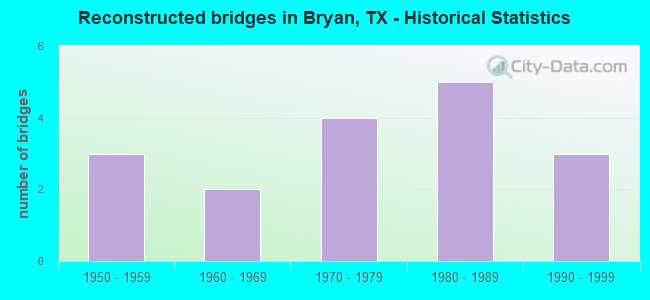
- Reconstructed bridges - Historical Statistics
- 31950-1959
- 21960-1969
- 41970-1979
- 51980-1989
- 31990-1999
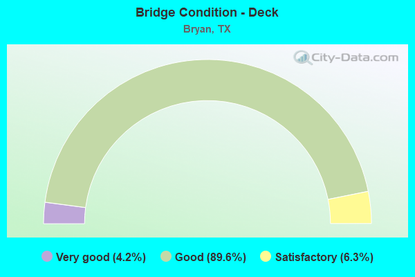
- Bridge Condition - Deck
- 4.2%Very good
- 89.6%Good
- 6.3%Satisfactory
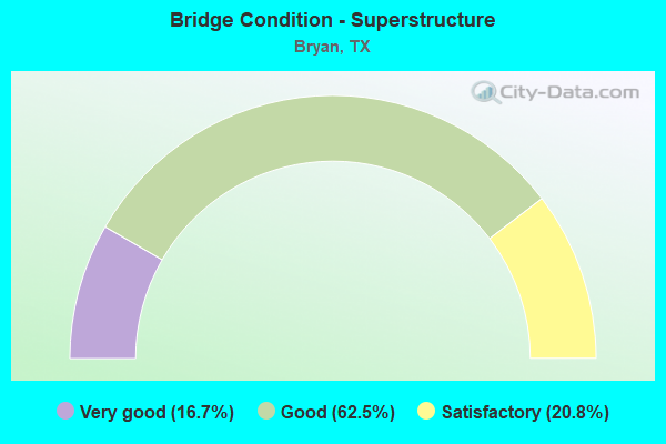
- Bridge Condition - Superstructure
- 16.7%Very good
- 62.5%Good
- 20.8%Satisfactory
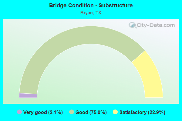
- Bridge Condition - Substructure
- 2.1%Very good
- 75.0%Good
- 22.9%Satisfactory
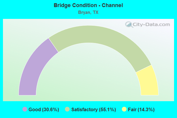
- Bridge Condition - Channel
- 30.6%Good
- 55.1%Satisfactory
- 14.3%Fair
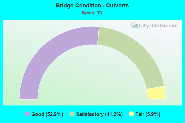
- Bridge Condition - Culverts
- 52.9%Good
- 41.2%Satisfactory
- 5.9%Fair
Find on map >> Show street view
Structure Number: 170210B00265001, Location: 0.10 MI E OF FM 2818 (Lat: 30.657028, Lng: -96.401081), Route carried "on" structure: City street , Year Built: 2007, Status: Open, Structure Length: 1.89m (6.20ft), Average Daily Traffic: 200 (year 2009), Truck Traffic: 1%, Average Future Daily Traffic: 500 (year 2029), Features Intersected: COTTONWOOD BRANCH, Facility Carried by Structure: BECK ST
Minimum Vertical Clearance: 30+ m (98+ ft), Kilometerpoint: 0.161, Lanes on structure: 2, Owner: City or Municipal Highway Agency, Approaching Roadway Width: 11.2m (36.7ft), Skew: 3 degrees, Material/Design: Concrete, Design/Construction: Culvert, Number Of Spans In Main Unit: 5, Length of Maximum Span: 3.0m (9.8ft), Curb or Sidewalk Widths: Left: 2.4m (7.9ft), Right: 2.4m (7.9ft)
Condition: Channel: Satisfactory, Culverts: Satisfactory, Operating Rating: 32.7 metric tons, Method Used To Determine Operating Rating: Field evaluation and documented engineering judgment, Inventory Rating: 24.5 metric tons, Method Used To Determine Inventory Rating: Field evaluation and documented engineering judgment, Structural Evaluation: Equal to present minimum criteria, Waterway Adequacy: Better than present minimum criteria, Approach Roadway Alignment: Equal to present desirable criteria, Designated Inspection Frequency: Every 24 months, Inspection Date: September 2021
Find on map >> Show street view
Structure Number: 170210B00265002, Location: 0.5 MI E OF FM 2818 (Lat: 30.657692, Lng: -96.394664), Route carried "on" structure: City street , Year Built: 2007, Status: Open, Structure Length: 2.32m (7.61ft), Average Daily Traffic: 200 (year 2009), Truck Traffic: 1%, Average Future Daily Traffic: 500 (year 2029), Features Intersected: COTTONWOOD BRANCH, Facility Carried by Structure: BECK ST
Minimum Vertical Clearance: 30+ m (98+ ft), Kilometerpoint: 0.805, Lanes on structure: 3, Owner: City or Municipal Highway Agency, Approaching Roadway Width: 11.3m (37.1ft), Skew: 4 degrees, Material/Design: Concrete, Design/Construction: Culvert, Number Of Spans In Main Unit: 5, Length of Maximum Span: 3.0m (9.8ft), Curb or Sidewalk Widths: Left: 2.6m (8.5ft), Right: 2.6m (8.5ft)
Condition: Channel: Satisfactory, Culverts: Good, Operating Rating: 32.7 metric tons, Method Used To Determine Operating Rating: Field evaluation and documented engineering judgment, Inventory Rating: 18.1 metric tons, Method Used To Determine Inventory Rating: Field evaluation and documented engineering judgment, Structural Evaluation: Somewhat better than minimum adequacy, Waterway Adequacy: Superior to present desirable criteria, Approach Roadway Alignment: Equal to present desirable criteria, Designated Inspection Frequency: Every 24 months, Inspection Date: September 2021
Find on map >> Show street view
Structure Number: 170210B00265003, Location: 0.75 MI E OF FM 2818 (Lat: 30.658297, Lng: -96.389394), Route carried "on" structure: City street , Year Built: 2007, Status: Open, Structure Length: 1.68m (5.51ft), Average Daily Traffic: 200 (year 2009), Truck Traffic: 1%, Average Future Daily Traffic: 500 (year 2029), Features Intersected: COTTONWOOD BRANCH, Facility Carried by Structure: BECK ST
Minimum Vertical Clearance: 30+ m (98+ ft), Kilometerpoint: 1.207, Lanes on structure: 3, Owner: City or Municipal Highway Agency, Approaching Roadway Width: 11.3m (37.1ft), Skew: 4 degrees, Material/Design: Concrete, Design/Construction: Culvert, Number Of Spans In Main Unit: 4, Length of Maximum Span: 2.7m (8.9ft), Curb or Sidewalk Widths: Left: 2.4m (7.9ft), Right: 2.4m (7.9ft)
Condition: Channel: Satisfactory, Culverts: Good, Operating Rating: 32.7 metric tons, Method Used To Determine Operating Rating: Field evaluation and documented engineering judgment, Inventory Rating: 24.5 metric tons, Method Used To Determine Inventory Rating: Field evaluation and documented engineering judgment, Structural Evaluation: Equal to present minimum criteria, Waterway Adequacy: Superior to present desirable criteria, Approach Roadway Alignment: Equal to present desirable criteria, Designated Inspection Frequency: Every 24 months, Inspection Date: September 2021
Find on map >> Show street view
Structure Number: 170210B00365001, Location: 0.1 MI SW OF SH 6 (Lat: 30.686517, Lng: -96.351278), Route carried "on" structure: City street , Year Built: 1965, Status: Open, Structure Length: 1.31m (4.30ft), Average Daily Traffic: 5,365 (year 2017), Average Future Daily Traffic: 2,000 (year 2035), Features Intersected: CARTERS CREEK TRIBUTARY, Facility Carried by Structure: E MLK JR ST
Minimum Vertical Clearance: 30+ m (98+ ft), Kilometerpoint: 3.384, Lanes on structure: 2, Owner: City or Municipal Highway Agency, Approaching Roadway Width: 7.3m (24.0ft), Material/Design: Concrete, Design/Construction: Culvert, Number Of Spans In Main Unit: 4, Length of Maximum Span: 3.0m (9.8ft), Curb or Sidewalk Widths: Left: 1.4m (4.6ft), Right: 0.0m, Curb-To-Curb Width: 8.4m (27.6ft), Out-to-Out Width: 10.2m (33.5ft)
Condition: Channel: Fair, Culverts: Satisfactory, Operating Rating: 32.7 metric tons, Method Used To Determine Operating Rating: Field evaluation and documented engineering judgment, Inventory Rating: 24.5 metric tons, Method Used To Determine Inventory Rating: Field evaluation and documented engineering judgment, Structural Evaluation: Equal to present minimum criteria, Deck Geometry: High priority of replacement, Waterway Adequacy: Equal to present minimum criteria, Approach Roadway Alignment: Equal to present desirable criteria, Designated Inspection Frequency: Every 24 months, Inspection Date: September 2021, Deck Structure Type: Concrete Cast-file-Place, Wearing Surface/Protective System: Wearing Surface: Bituminous
Find on map >> Show street view
Structure Number: 170210B00365002, Location: 0.85 MI NE OF SH 6 (Lat: 30.697067, Lng: -96.339422), Route carried "on" structure: City street , Year Built: 1989, Status: Open, Structure Length: 0.70m (2.30ft), Average Daily Traffic: 1,400 (year 2015), Truck Traffic: 1%, Average Future Daily Traffic: 1,800 (year 2035), Features Intersected: CARTERS CREEK, Facility Carried by Structure: OLD RELIANCE RD
Minimum Vertical Clearance: 30+ m (98+ ft), Kilometerpoint: 12.794, Lanes on structure: 2, Owner: City or Municipal Highway Agency, Approaching Roadway Width: 6.7m (22.0ft), Skew: 1 degrees, Material/Design: Concrete, Design/Construction: Culvert, Number Of Spans In Main Unit: 2, Length of Maximum Span: 2.7m (8.9ft), Curb-To-Curb Width: 13.3m (43.6ft), Out-to-Out Width: 13.7m (44.9ft)
Condition: Channel: Good, Culverts: Satisfactory, Operating Rating: 32.7 metric tons, Method Used To Determine Operating Rating: Field evaluation and documented engineering judgment, Inventory Rating: 24.5 metric tons, Method Used To Determine Inventory Rating: Field evaluation and documented engineering judgment, Structural Evaluation: Equal to present minimum criteria, Deck Geometry: Better than present minimum criteria, Waterway Adequacy: Better than present minimum criteria, Approach Roadway Alignment: Equal to present desirable criteria, Designated Inspection Frequency: Every 24 months, Inspection Date: September 2021, Deck Structure Type: Concrete Cast-file-Place, Wearing Surface/Protective System: Wearing Surface: Bituminous
Find on map >> Show street view
Structure Number: 170210B00369001, Location: 0.03 MI NW OF E MLK JR ST (Lat: 30.684089, Lng: -96.358622), Route carried "on" structure: City street , Year Built: 1965, Status: Open, Structure Length: 0.85m (2.79ft), Average Daily Traffic: 1,600 (year 2015), Average Future Daily Traffic: 2,000 (year 2035), Features Intersected: CARTERS CREEK TRIBUTARY, Facility Carried by Structure: WACO ST
Minimum Vertical Clearance: 30+ m (98+ ft), Kilometerpoint: 1.170, Lanes on structure: 2, Owner: City or Municipal Highway Agency, Approaching Roadway Width: 6.1m (20.0ft), Skew: 1 degrees, Material/Design: Concrete, Design/Construction: Culvert, Number Of Spans In Main Unit: 3, Length of Maximum Span: 2.4m (7.9ft), Curb-To-Curb Width: 7.3m (24.0ft), Out-to-Out Width: 10.2m (33.5ft)
Condition: Channel: Satisfactory, Culverts: Satisfactory, Operating Rating: 32.7 metric tons, Method Used To Determine Operating Rating: Field evaluation and documented engineering judgment, Inventory Rating: 24.5 metric tons, Method Used To Determine Inventory Rating: Field evaluation and documented engineering judgment, Structural Evaluation: Equal to present minimum criteria, Deck Geometry: Meets minimum limits, Waterway Adequacy: Equal to present minimum criteria, Approach Roadway Alignment: Equal to present desirable criteria, Designated Inspection Frequency: Every 24 months, Inspection Date: September 2021, Deck Structure Type: Concrete Cast-file-Place, Wearing Surface/Protective System: Wearing Surface: Bituminous
Find on map >> Show street view
Structure Number: 170210B00379001, Location: 0.05 MI NW OF E MLK JR ST (Lat: 30.686114, Lng: -96.353844), Route carried "on" structure: City street , Year Built: 1965, Status: Open, Structure Length: 1.04m (3.41ft), Average Daily Traffic: 972 (year 2017), Average Future Daily Traffic: 1,500 (year 2035), Features Intersected: CARTERS CREEK TRIB, Facility Carried by Structure: DUMAS DR
Minimum Vertical Clearance: 30+ m (98+ ft), Kilometerpoint: 0.480, Lanes on structure: 2, Owner: City or Municipal Highway Agency, Approaching Roadway Width: 9.8m (32.2ft), Skew: 1 degrees, Material/Design: Concrete, Design/Construction: Culvert, Number Of Spans In Main Unit: 3, Length of Maximum Span: 3.0m (9.8ft), Curb or Sidewalk Widths: Left: 1.1m (3.6ft), Right: 1.1m (3.6ft), Curb-To-Curb Width: 9.8m (32.2ft), Out-to-Out Width: 12.6m (41.3ft)
Condition: Channel: Fair, Culverts: Satisfactory, Operating Rating: 32.7 metric tons, Method Used To Determine Operating Rating: Field evaluation and documented engineering judgment, Inventory Rating: 24.5 metric tons, Method Used To Determine Inventory Rating: Field evaluation and documented engineering judgment, Structural Evaluation: Equal to present minimum criteria, Deck Geometry: Equal to present minimum criteria, Waterway Adequacy: Better than present minimum criteria, Approach Roadway Alignment: Equal to present desirable criteria, Designated Inspection Frequency: Every 24 months, Inspection Date: September 2021, Deck Structure Type: Concrete Cast-file-Place, Wearing Surface/Protective System: Wearing Surface: Bituminous
Find on map >> Show street view
Structure Number: 170210B00500001, Location: 1.10 MI N OF FM 1179 (Lat: 30.665597, Lng: -96.348244), Route carried "on" structure: City street , Year Built: 1973, Year Reconstructed: 1983, Status: Open, Structure Length: 0.67m (2.20ft), Average Daily Traffic: 18,000 (year 2015), Average Future Daily Traffic: 20,000 (year 2035), Features Intersected: BRIAR CREEK, Facility Carried by Structure: E VILLA MARIA RD
Minimum Vertical Clearance: 30+ m (98+ ft), Kilometerpoint: 0.697, Lanes on structure: 5, Owner: City or Municipal Highway Agency, Approaching Roadway Width: 17.7m (58.1ft), Material/Design: Concrete, Design/Construction: Culvert, Number Of Spans In Main Unit: 2, Length of Maximum Span: 3.0m (9.8ft), Curb or Sidewalk Widths: Left: 1.9m (6.2ft), Right: 1.9m (6.2ft), Curb-To-Curb Width: 17.7m (58.1ft), Out-to-Out Width: 22.3m (73.2ft)
Condition: Channel: Good, Culverts: Good, Operating Rating: 39.9 metric tons, Method Used To Determine Operating Rating: Load Factor (LF), Inventory Rating: 23.6 metric tons, Method Used To Determine Inventory Rating: Load Factor (LF), Structural Evaluation: Somewhat better than minimum adequacy, Deck Geometry: High priority of replacement, Waterway Adequacy: Equal to present minimum criteria, Approach Roadway Alignment: Equal to present desirable criteria, Length Of Structure Improvement: 0.64m (2.10ft), Designated Inspection Frequency: Every 24 months, Inspection Date: September 2021, Bridge Improvement Cost: $2,000, Roadway Improvement Cost: $1,000, Total Project Cost: $3,000, Deck Structure Type: Concrete Cast-file-Place, Wearing Surface/Protective System: Wearing Surface: Bituminous
Find on map >> Show street view
Structure Number: 170210B00509001, Location: 0.25 MI E OF ETHEL BLVD (Lat: 30.649469, Lng: -96.352375), Route carried "on" structure: City street , Year Built: 1960, Status: Posted for load, Structure Length: 0.70m (2.30ft), Average Daily Traffic: 1,500 (year 2015), Average Future Daily Traffic: 2,000 (year 2035), Features Intersected: BURTON CREEK, Facility Carried by Structure: BURTON DR
Minimum Vertical Clearance: 30+ m (98+ ft), Kilometerpoint: 0.404, Lanes on structure: 2, Owner: City or Municipal Highway Agency, Approaching Roadway Width: 9.8m (32.2ft), Material/Design: Concrete, Design/Construction: Culvert, Number Of Spans In Main Unit: 3, Length of Maximum Span: 2.1m (6.9ft), Curb or Sidewalk Widths: Left: 1.0m (3.3ft), Right: 1.0m (3.3ft), Curb-To-Curb Width: 9.8m (32.2ft), Out-to-Out Width: 12.2m (40.0ft)
Condition: Channel: Fair, Culverts: Fair, Operating Rating: 32.7 metric tons, Method Used To Determine Operating Rating: Field evaluation and documented engineering judgment, Inventory Rating: 24.5 metric tons, Method Used To Determine Inventory Rating: Field evaluation and documented engineering judgment, Structural Evaluation: Somewhat better than minimum adequacy, Deck Geometry: Somewhat better than minimum adequacy, Waterway Adequacy: Meets minimum limits, Approach Roadway Alignment: Equal to present desirable criteria, Designated Inspection Frequency: Every 24 months, Inspection Date: September 2021, Deck Structure Type: Concrete Cast-file-Place, Wearing Surface/Protective System: Wearing Surface: Bituminous
Find on map >> Show street view
Structure Number: 170210B00526001, Location: 0.45 MI N OF 29TH ST (Lat: 30.661828, Lng: -96.339997), Route carried "on" structure: City street , Year Built: 1977, Status: Open, Structure Length: 2.07m (6.79ft), Average Daily Traffic: 2,497 (year 2019), Average Future Daily Traffic: 1,500 (year 2035), Features Intersected: BRIAR CREEK, Facility Carried by Structure: BROADMOOR DR
Minimum Vertical Clearance: 30+ m (98+ ft), Kilometerpoint: 0.484, Lanes on structure: 2, Owner: City or Municipal Highway Agency, Approaching Roadway Width: 11.0m (36.1ft), Material/Design: Concrete, Design/Construction: Culvert, Number Of Spans In Main Unit: 7, Length of Maximum Span: 2.7m (8.9ft), Curb-To-Curb Width: 13.7m (44.9ft), Out-to-Out Width: 14.1m (46.3ft)
Condition: Channel: Satisfactory, Culverts: Satisfactory, Operating Rating: 32.7 metric tons, Method Used To Determine Operating Rating: Field evaluation and documented engineering judgment, Inventory Rating: 24.5 metric tons, Method Used To Determine Inventory Rating: Field evaluation and documented engineering judgment, Structural Evaluation: Equal to present minimum criteria, Deck Geometry: Superior to present desirable criteria, Waterway Adequacy: High priority of corrective action, Approach Roadway Alignment: Equal to present desirable criteria, Length Of Structure Improvement: 2.04m (6.69ft), Designated Inspection Frequency: Every 24 months, Inspection Date: September 2021, Bridge Improvement Cost: $6,000, Roadway Improvement Cost: $2,000, Total Project Cost: $8,000, Deck Structure Type: Concrete Cast-file-Place, Wearing Surface/Protective System: Wearing Surface: Monolithic Concrete
Find on map >> Show street view
Structure Number: 170210B00526002, Location: 0.55 MI S OF FM 1179 (Lat: 30.643022, Lng: -96.345464), Route carried "on" structure: City street , Year Built: 1965, Year Reconstructed: 1975, Status: Open, Structure Length: 1.52m (4.99ft), Average Daily Traffic: 5,000 (year 2015), Average Future Daily Traffic: 5,500 (year 2035), Features Intersected: BURTON CREEK, Facility Carried by Structure: BROADMOOR DR
Minimum Vertical Clearance: 30+ m (98+ ft), Kilometerpoint: 8.867, Lanes on structure: 2, Owner: City or Municipal Highway Agency, Approaching Roadway Width: 11.0m (36.1ft), Material/Design: Concrete, Design/Construction: Culvert, Number Of Spans In Main Unit: 5, Length of Maximum Span: 3.0m (9.8ft), Curb or Sidewalk Widths: Left: 1.0m (3.3ft), Right: 1.0m (3.3ft), Curb-To-Curb Width: 11.0m (36.1ft), Out-to-Out Width: 13.4m (44.0ft)
Condition: Channel: Good, Culverts: Good, Operating Rating: 32.7 metric tons, Method Used To Determine Operating Rating: Field evaluation and documented engineering judgment, Inventory Rating: 24.5 metric tons, Method Used To Determine Inventory Rating: Field evaluation and documented engineering judgment, Structural Evaluation: Equal to present minimum criteria, Deck Geometry: Somewhat better than minimum adequacy, Waterway Adequacy: Better than present minimum criteria, Approach Roadway Alignment: Equal to present desirable criteria, Designated Inspection Frequency: Every 24 months, Inspection Date: September 2021, Deck Structure Type: Concrete Cast-file-Place, Wearing Surface/Protective System: Wearing Surface: Bituminous
Find on map >> Show street view
Structure Number: 170210B00557001, Location: 0.7 MI SW OF BROADMOOR DR (Lat: 30.640914, Lng: -96.335886), Route carried "on" structure: City street , Year Built: 1975, Status: Open, Structure Length: 1.85m (6.07ft), Average Daily Traffic: 1,453 (year 2017), Average Future Daily Traffic: 2,500 (year 2035), Design Load: HS 20, Features Intersected: BURTON CREEK, Facility Carried by Structure: TANGLEWOOD DR
Minimum Vertical Clearance: 30+ m (98+ ft), Kilometerpoint: 0.245, Lanes on structure: 2, Owner: City or Municipal Highway Agency, Approaching Roadway Width: 8.5m (27.9ft), Material/Design: Concrete, Design/Construction: Stringer/Multi-beam, Number Of Spans In Main Unit: 2, Length of Maximum Span: 9.1m (29.9ft), Curb or Sidewalk Widths: Left: 1.2m (3.9ft), Right: 1.2m (3.9ft), Curb-To-Curb Width: 8.5m (27.9ft), Out-to-Out Width: 11.6m (38.1ft)
Condition: Deck: Satisfactory, Superstructure: Good, Substructure: Good, Channel: Fair, Operating Rating: 68.0 metric tons, Method Used To Determine Operating Rating: Load Factor (LF), Inventory Rating: 40.8 metric tons, Method Used To Determine Inventory Rating: Load Factor (LF), Structural Evaluation: Better than present minimum criteria, Deck Geometry: Somewhat better than minimum adequacy, Waterway Adequacy: Better than present minimum criteria, Approach Roadway Alignment: Equal to present desirable criteria, Designated Inspection Frequency: Every 24 months, Inspection Date: September 2021, Deck Structure Type: Concrete Cast-file-Place
Find on map >> Show street view
Structure Number: 170210B00592001, Location: 0.05 MI SE OF 29TH ST (Lat: 30.641197, Lng: -96.331881), Route carried "on" structure: City street , Year Built: 1965, Status: Open, Structure Length: 2.77m (9.09ft), Average Daily Traffic: 2,457 (year 2017), Average Future Daily Traffic: 3,000 (year 2035), Features Intersected: BURTON CREEK, Facility Carried by Structure: ROSEMARY DR
Minimum Vertical Clearance: 30+ m (98+ ft), Kilometerpoint: 1.373, Lanes on structure: 2, Owner: City or Municipal Highway Agency, Approaching Roadway Width: 7.3m (24.0ft), Material/Design: Concrete, Design/Construction: Stringer/Multi-beam, Number Of Spans In Main Unit: 3, Length of Maximum Span: 9.1m (29.9ft), Curb or Sidewalk Widths: Left: 0.9m (3.0ft), Right: 0.9m (3.0ft), Curb-To-Curb Width: 9.8m (32.2ft), Out-to-Out Width: 12.2m (40.0ft)
Condition: Deck: Good, Superstructure: Good, Substructure: Good, Channel: Satisfactory, Operating Rating: 32.7 metric tons, Method Used To Determine Operating Rating: Field evaluation and documented engineering judgment, Inventory Rating: 24.5 metric tons, Method Used To Determine Inventory Rating: Field evaluation and documented engineering judgment, Structural Evaluation: Equal to present minimum criteria, Deck Geometry: Meets minimum limits, Waterway Adequacy: Better than present minimum criteria, Approach Roadway Alignment: Equal to present desirable criteria, Designated Inspection Frequency: Every 24 months, Inspection Date: September 2021, Deck Structure Type: Concrete Cast-file-Place
Find on map >> Show street view
Structure Number: 170210B00605001, Location: 0.3 MI S OF INDEPENDENCE (Lat: 30.656114, Lng: -96.406761), Route carried "on" structure: City street , Year Built: 1980, Status: Open, Structure Length: 1.19m (3.90ft), Average Daily Traffic: 800 (year 2015), Average Future Daily Traffic: 1,000 (year 2035), Design Load: HS 20, Features Intersected: COTTONWOOD BRANCH, Facility Carried by Structure: INDUSTRIAL BLVD
Minimum Vertical Clearance: 30+ m (98+ ft), Kilometerpoint: 0.483, Lanes on structure: 2, Owner: City or Municipal Highway Agency, Approaching Roadway Width: 7.6m (24.9ft), Material/Design: Concrete, Design/Construction: Culvert, Number Of Spans In Main Unit: 4, Length of Maximum Span: 2.7m (8.9ft), Curb or Sidewalk Widths: Left: 1.0m (3.3ft), Right: 1.0m (3.3ft), Curb-To-Curb Width: 7.6m (24.9ft), Out-to-Out Width: 10.4m (34.1ft)
Condition: Channel: Satisfactory, Culverts: Satisfactory, Operating Rating: 39.9 metric tons, Method Used To Determine Operating Rating: Load Factor (LF), Inventory Rating: 23.6 metric tons, Method Used To Determine Inventory Rating: Load Factor (LF), Structural Evaluation: Equal to present minimum criteria, Deck Geometry: Meets minimum limits, Waterway Adequacy: Meets minimum limits, Approach Roadway Alignment: Equal to present desirable criteria, Designated Inspection Frequency: Every 24 months, Inspection Date: September 2021, Deck Structure Type: Concrete Cast-file-Place
Find on map >> Show street view
Structure Number: 170210B00653001, Location: 0.05 MI NW OF FM 1179 (Lat: 30.641803, Lng: -96.356156), Route carried "on" structure: City street , Year Built: 1965, Status: Open, Structure Length: 0.82m (2.69ft), Average Daily Traffic: 4,800 (year 2015), Truck Traffic: 5%, Average Future Daily Traffic: 5,500 (year 2035), Features Intersected: BURTON CREEK TRIBUTARY, Facility Carried by Structure: CAVITT AVE
Minimum Vertical Clearance: 30+ m (98+ ft), Kilometerpoint: 2.255, Lanes on structure: 2, Owner: City or Municipal Highway Agency, Approaching Roadway Width: 12.2m (40.0ft), Material/Design: Concrete, Design/Construction: Culvert, Number Of Spans In Main Unit: 3, Length of Maximum Span: 2.4m (7.9ft), Curb or Sidewalk Widths: Left: 1.4m (4.6ft), Right: 1.4m (4.6ft), Curb-To-Curb Width: 12.1m (39.7ft), Out-to-Out Width: 15.3m (50.2ft)
Condition: Channel: Satisfactory, Culverts: Satisfactory, Operating Rating: 32.7 metric tons, Method Used To Determine Operating Rating: Field evaluation and documented engineering judgment, Inventory Rating: 24.5 metric tons, Method Used To Determine Inventory Rating: Field evaluation and documented engineering judgment, Structural Evaluation: Equal to present minimum criteria, Deck Geometry: Somewhat better than minimum adequacy, Waterway Adequacy: Better than present minimum criteria, Approach Roadway Alignment: Equal to present desirable criteria, Designated Inspection Frequency: Every 24 months, Inspection Date: September 2021, Deck Structure Type: Concrete Cast-file-Place
Find on map >> Show street view
Structure Number: 170210B00805001, Location: 0.25 MI NW OF SH 21 (Lat: 30.685597, Lng: -96.385397), Route carried "on" structure: City street , Year Built: 2012, Status: Open, Structure Length: 0.82m (2.69ft), Average Daily Traffic: 500 (year 2015), Average Future Daily Traffic: 500 (year 2035), Design Load: HL 93, Features Intersected: STILL CREEK TRIBUTARY, Facility Carried by Structure: W MLK JR ST
Minimum Vertical Clearance: 30+ m (98+ ft), Kilometerpoint: 0.402, Lanes on structure: 2, Owner: City or Municipal Highway Agency, Approaching Roadway Width: 11.0m (36.1ft), Skew: 1 degrees, Material/Design: Concrete, Design/Construction: Culvert, Number Of Spans In Main Unit: 3, Length of Maximum Span: 2.4m (7.9ft), Curb or Sidewalk Widths: Left: 2.1m (6.9ft), Right: 2.4m (7.9ft), Curb-To-Curb Width: 11.1m (36.4ft), Out-to-Out Width: 16.2m (53.1ft)
Condition: Channel: Good, Culverts: Good, Operating Rating: 54.4 metric tons, Method Used To Determine Operating Rating: Assigned ratings based on Load and Resistance Factor Design (LRFD) reported in metric tons, Inventory Rating: 32.7 metric tons, Method Used To Determine Inventory Rating: Assigned ratings based on Load and Resistance Factor Design (LRFD) reported in metric tons, Structural Evaluation: Better than present minimum criteria, Deck Geometry: Better than present minimum criteria, Waterway Adequacy: Better than present minimum criteria, Approach Roadway Alignment: Equal to present desirable criteria, Designated Inspection Frequency: Every 24 months, Inspection Date: September 2021, Deck Structure Type: Concrete Cast-file-Place, Wearing Surface/Protective System: Wearing Surface: Monolithic Concrete
Find on map >> Show street view
Structure Number: 170210B00825001, Location: 0.35 MI W OF FM 60 (Lat: 30.652586, Lng: -96.300864), Route carried "on" structure: City street , Year Built: 2000, Status: Open, Structure Length: 1.34m (4.40ft), Average Daily Traffic: 1,500 (year 2015), Average Future Daily Traffic: 2,000 (year 2035), Design Load: HS 20, Features Intersected: HUDSON CREEK, Facility Carried by Structure: COPPERFIELD DR
Minimum Vertical Clearance: 30+ m (98+ ft), Kilometerpoint: 0.563, Lanes on structure: 2, Owner: City or Municipal Highway Agency, Approaching Roadway Width: 12.2m (40.0ft), Material/Design: Concrete, Design/Construction: Culvert, Number Of Spans In Main Unit: 5, Length of Maximum Span: 2.4m (7.9ft), Curb or Sidewalk Widths: Left: 1.8m (5.9ft), Right: 1.8m (5.9ft), Curb-To-Curb Width: 12.2m (40.0ft), Out-to-Out Width: 32.9m (107.9ft)
Condition: Channel: Satisfactory, Culverts: Satisfactory, Operating Rating: 44.4 metric tons, Method Used To Determine Operating Rating: No rating analysis performed, Inventory Rating: 32.7 metric tons, Method Used To Determine Inventory Rating: No rating analysis performed, Structural Evaluation: Equal to present minimum criteria, Deck Geometry: Better than present minimum criteria, Waterway Adequacy: Better than present minimum criteria, Approach Roadway Alignment: Equal to present desirable criteria, Designated Inspection Frequency: Every 24 months, Inspection Date: September 2021, Deck Structure Type: Concrete Cast-file-Place, Wearing Surface/Protective System: Wearing Surface: Bituminous
Find on map >> Show street view
Structure Number: 170210B00825002, Location: 0.25 MI NE OF FM 158 (Lat: 30.665167, Lng: -96.299911), Route carried "on" structure: City street , Year Built: 1982, Status: Open, Structure Length: 0.91m (2.99ft), Average Daily Traffic: 5,000 (year 2015), Average Future Daily Traffic: 6,000 (year 2035), Design Load: HS 20, Features Intersected: HUDSON CREEK, Facility Carried by Structure: COPPERFIELD DR
Minimum Vertical Clearance: 30+ m (98+ ft), Kilometerpoint: 0.402, Lanes on structure: 2, Owner: City or Municipal Highway Agency, Approaching Roadway Width: 12.2m (40.0ft), Material/Design: Concrete, Design/Construction: Culvert, Number Of Spans In Main Unit: 4, Length of Maximum Span: 2.1m (6.9ft), Curb or Sidewalk Widths: Left: 2.0m (6.6ft), Right: 2.0m (6.6ft), Curb-To-Curb Width: 12.2m (40.0ft), Out-to-Out Width: 16.6m (54.5ft)
Condition: Channel: Good, Culverts: Good, Operating Rating: 39.9 metric tons, Method Used To Determine Operating Rating: Load Factor (LF), Inventory Rating: 23.6 metric tons, Method Used To Determine Inventory Rating: Load Factor (LF), Structural Evaluation: Equal to present minimum criteria, Deck Geometry: Equal to present minimum criteria, Waterway Adequacy: Better than present minimum criteria, Approach Roadway Alignment: Equal to present desirable criteria, Designated Inspection Frequency: Every 24 months, Inspection Date: September 2021, Deck Structure Type: Concrete Cast-file-Place, Wearing Surface/Protective System: Wearing Surface: Bituminous
Find on map >> Show street view
Structure Number: 170210B00865001, Location: 0.65 MI S OF VILLA MARIA (Lat: 30.619933, Lng: -96.386472), Route carried "on" structure: City street , Year Built: 1978, Status: Posted for load, Structure Length: 0.82m (2.69ft), Average Daily Traffic: 500 (year 2015), Average Future Daily Traffic: 500 (year 2035), Features Intersected: TURKEY CREEK, Facility Carried by Structure: WESTWOOD MAIN DR S
Minimum Vertical Clearance: 30+ m (98+ ft), Kilometerpoint: 1.046, Lanes on structure: 2, Owner: City or Municipal Highway Agency, Approaching Roadway Width: 11.0m (36.1ft), Material/Design: Steel, Design/Construction: Culvert, Number Of Spans In Main Unit: 1, Length of Maximum Span: 8.2m (26.9ft), Curb or Sidewalk Widths: Left: 1.2m (3.9ft), Right: 0.0m
Condition: Channel: Fair, Culverts: Fair, Operating Rating: 32.7 metric tons, Method Used To Determine Operating Rating: No rating analysis performed, Inventory Rating: 24.5 metric tons, Method Used To Determine Inventory Rating: No rating analysis performed, Structural Evaluation: Somewhat better than minimum adequacy, Waterway Adequacy: Better than present minimum criteria, Approach Roadway Alignment: Equal to present desirable criteria, Designated Inspection Frequency: Every 24 months, Inspection Date: September 2021
Find on map >> Show street view
Structure Number: 170210B00880001, Location: 0.5 MI S OF FM 1179 (Lat: 30.611669, Lng: -96.397822), Route carried "on" structure: City street , Year Built: 2004, Status: Open, Structure Length: 1.46m (4.79ft), Average Daily Traffic: 500 (year 2015), Average Future Daily Traffic: 1,000 (year 2035), Design Load: HS 20, Features Intersected: TURKEY CREEK, Facility Carried by Structure: S TRADITIONS DR
Minimum Vertical Clearance: 30+ m (98+ ft), Kilometerpoint: 0.805, Lanes on structure: 2, Owner: City or Municipal Highway Agency, Approaching Roadway Width: 9.8m (32.2ft), Material/Design: Concrete, Design/Construction: Culvert, Number Of Spans In Main Unit: 4, Length of Maximum Span: 3.0m (9.8ft), Curb or Sidewalk Widths: Left: 0.0m, Right: 2.4m (7.9ft)
Condition: Channel: Satisfactory, Culverts: Good, Operating Rating: 54.4 metric tons, Method Used To Determine Operating Rating: Assigned rating based on Load Factor Design (LFD) reported in metric tons, Inventory Rating: 32.7 metric tons, Method Used To Determine Inventory Rating: Assigned rating based on Load Factor Design (LFD) reported in metric tons, Structural Evaluation: Better than present minimum criteria, Waterway Adequacy: Better than present minimum criteria, Approach Roadway Alignment: Equal to present desirable criteria, Designated Inspection Frequency: Every 24 months, Inspection Date: September 2021
Find on map >> Show street view
Structure Number: 170210B00880002, Location: 0.4 MI SE OF FM 1179 (Lat: 30.615164, Lng: -96.392394), Route carried "on" structure: City street , Year Built: 2006, Status: Open, Structure Length: 1.31m (4.30ft), Average Daily Traffic: 500 (year 2015), Average Future Daily Traffic: 1,000 (year 2035), Design Load: HS 20, Features Intersected: TURKEY CREEK, Facility Carried by Structure: N TRADITIONS DR
Minimum Vertical Clearance: 30+ m (98+ ft), Kilometerpoint: 0.644, Lanes on structure: 2, Owner: City or Municipal Highway Agency, Approaching Roadway Width: 9.8m (32.2ft), Material/Design: Concrete, Design/Construction: Culvert, Number Of Spans In Main Unit: 4, Length of Maximum Span: 3.0m (9.8ft), Curb or Sidewalk Widths: Left: 0.0m, Right: 2.4m (7.9ft), Curb-To-Curb Width: 9.8m (32.2ft), Out-to-Out Width: 21.9m (71.9ft)
Condition: Channel: Satisfactory, Culverts: Satisfactory, Operating Rating: 54.4 metric tons, Method Used To Determine Operating Rating: Assigned rating based on Load Factor Design (LFD) reported in metric tons, Inventory Rating: 32.7 metric tons, Method Used To Determine Inventory Rating: Assigned rating based on Load Factor Design (LFD) reported in metric tons, Structural Evaluation: Equal to present minimum criteria, Deck Geometry: Equal to present minimum criteria, Waterway Adequacy: Better than present minimum criteria, Approach Roadway Alignment: Equal to present desirable criteria, Designated Inspection Frequency: Every 24 months, Inspection Date: September 2021, Deck Structure Type: Concrete Cast-file-Place, Wearing Surface/Protective System: Wearing Surface: Bituminous
Find on map >> Show street view
Structure Number: 170210B00885001, Location: 0.10 MI S OF BECK ST (Lat: 30.656453, Lng: -96.394903), Route carried "on" structure: City street , Year Built: 2007, Status: Open, Structure Length: 1.89m (6.20ft), Average Daily Traffic: 200 (year 2009), Truck Traffic: 1%, Average Future Daily Traffic: 500 (year 2029), Features Intersected: COTTONWOOD BRANCH, Facility Carried by Structure: SILKWOOD DR
Minimum Vertical Clearance: 30+ m (98+ ft), Kilometerpoint: 0.161, Lanes on structure: 2, Owner: City or Municipal Highway Agency, Approaching Roadway Width: 11.3m (37.1ft), Skew: 9 degrees, Material/Design: Concrete, Design/Construction: Culvert, Number Of Spans In Main Unit: 5, Length of Maximum Span: 3.0m (9.8ft), Curb or Sidewalk Widths: Left: 1.8m (5.9ft), Right: 1.5m (4.9ft)
Condition: Channel: Good, Culverts: Good, Operating Rating: 32.7 metric tons, Method Used To Determine Operating Rating: Field evaluation and documented engineering judgment, Inventory Rating: 24.5 metric tons, Method Used To Determine Inventory Rating: Field evaluation and documented engineering judgment, Structural Evaluation: Equal to present minimum criteria, Waterway Adequacy: Superior to present desirable criteria, Approach Roadway Alignment: Equal to present desirable criteria, Designated Inspection Frequency: Every 24 months, Inspection Date: September 2021
Find on map >> Show street view
Structure Number: 170210B00900001, Location: 0.65 MI NW OF FM 158 (Lat: 30.680486, Lng: -96.336900), Route carried "on" structure: City street , Year Built: 1998, Status: Open, Structure Length: 2.13m (6.99ft), Average Daily Traffic: 3,000 (year 2015), Average Future Daily Traffic: 4,000 (year 2035), Design Load: HS 20, Features Intersected: CARTERS CREEK TRIBUTARY, Facility Carried by Structure: AUSTINS COLONY PKW
Minimum Vertical Clearance: 30+ m (98+ ft), Kilometerpoint: 1.046, Lanes on structure: 4, Owner: City or Municipal Highway Agency, Approaching Roadway Width: 15.2m (49.9ft), Skew: 1 degrees, Material/Design: Concrete, Design/Construction: Culvert, Number Of Spans In Main Unit: 5, Length of Maximum Span: 3.7m (12.1ft), Curb or Sidewalk Widths: Left: 2.2m (7.2ft), Right: 2.2m (7.2ft)
Condition: Channel: Good, Culverts: Good, Operating Rating: 39.9 metric tons, Method Used To Determine Operating Rating: Load Factor (LF), Inventory Rating: 23.6 metric tons, Method Used To Determine Inventory Rating: Load Factor (LF), Structural Evaluation: Equal to present minimum criteria, Waterway Adequacy: Superior to present desirable criteria, Approach Roadway Alignment: Equal to present desirable criteria, Designated Inspection Frequency: Every 24 months, Inspection Date: September 2021
Find on map >> Show street view
Structure Number: 170210B01000001, Location: 0.37 MI S OF FM 158 (Lat: 30.654494, Lng: -96.297464), Route carried "on" structure: City street , Year Built: 2000, Status: Open, Structure Length: 1.04m (3.41ft), Average Daily Traffic: 1,000 (year 2015), Average Future Daily Traffic: 1,500 (year 2035), Design Load: HS 20, Features Intersected: DRAIN, Facility Carried by Structure: PENDLETON DR
Minimum Vertical Clearance: 30+ m (98+ ft), Kilometerpoint: 0.322, Lanes on structure: 2, Owner: City or Municipal Highway Agency, Approaching Roadway Width: 11.6m (38.1ft), Skew: 4 degrees, Material/Design: Concrete, Design/Construction: Culvert, Number Of Spans In Main Unit: 3, Length of Maximum Span: 3.0m (9.8ft), Curb or Sidewalk Widths: Left: 2.0m (6.6ft), Right: 2.0m (6.6ft)
Condition: Channel: Good, Culverts: Good, Operating Rating: 44.4 metric tons, Method Used To Determine Operating Rating: No rating analysis performed, Inventory Rating: 32.7 metric tons, Method Used To Determine Inventory Rating: No rating analysis performed, Structural Evaluation: Better than present minimum criteria, Waterway Adequacy: Better than present minimum criteria, Approach Roadway Alignment: Equal to present desirable criteria, Designated Inspection Frequency: Every 24 months, Inspection Date: September 2021
Find on map >> Show street view
Structure Number: 170210B01001001, Location: 0.35 MI NE OF THORNBERRY (Lat: 30.693772, Lng: -96.328753), Route carried "on" structure: City street , Year Built: 2007, Status: Open, Structure Length: 0.82m (2.69ft), Average Daily Traffic: 500 (year 2013), Truck Traffic: 1%, Average Future Daily Traffic: 1,000 (year 2033), Design Load: HS 20, Features Intersected: CARTERS CREEK, Facility Carried by Structure: AUSTINS ESTATES DR
Minimum Vertical Clearance: 30+ m (98+ ft), Kilometerpoint: 0.563, Lanes on structure: 2, Owner: City or Municipal Highway Agency, Approaching Roadway Width: 7.6m (24.9ft), Material/Design: Concrete, Design/Construction: Culvert, Number Of Spans In Main Unit: 4, Length of Maximum Span: 1.8m (5.9ft), Curb-To-Curb Width: 7.6m (24.9ft), Out-to-Out Width: 13.3m (43.6ft)
Condition: Channel: Good, Culverts: Good, Operating Rating: 54.4 metric tons, Method Used To Determine Operating Rating: Assigned rating based on Load Factor Design (LFD) reported in metric tons, Inventory Rating: 32.7 metric tons, Method Used To Determine Inventory Rating: Assigned rating based on Load Factor Design (LFD) reported in metric tons, Structural Evaluation: Better than present minimum criteria, Deck Geometry: Meets minimum limits, Waterway Adequacy: Better than present minimum criteria, Approach Roadway Alignment: Equal to present desirable criteria, Designated Inspection Frequency: Every 24 months, Inspection Date: September 2021, Deck Structure Type: Concrete Cast-file-Place, Wearing Surface/Protective System: Wearing Surface: Bituminous
Find on map >> Show street view
Structure Number: 170210B01002001, Location: 0.45 MI NW OF FM 1179 (Lat: 30.679792, Lng: -96.319364), Route carried "on" structure: City street , Year Built: 2012, Status: Open, Structure Length: 0.70m (2.30ft), Average Daily Traffic: 500 (year 2013), Truck Traffic: 1%, Average Future Daily Traffic: 1,000 (year 2033), Design Load: HL 93, Features Intersected: CARTERS CREEK REL NO 2, Facility Carried by Structure: THORNBERRY DR
Minimum Vertical Clearance: 30+ m (98+ ft), Kilometerpoint: 0.724, Lanes on structure: 2, Owner: City or Municipal Highway Agency, Approaching Roadway Width: 11.0m (36.1ft), Material/Design: Concrete, Design/Construction: Culvert, Number Of Spans In Main Unit: 3, Length of Maximum Span: 2.1m (6.9ft), Curb or Sidewalk Widths: Left: 2.4m (7.9ft), Right: 0.0m, Curb-To-Curb Width: 10.9m (35.8ft), Out-to-Out Width: 25.3m (83.0ft)
Condition: Channel: Good, Culverts: Good, Operating Rating: 54.4 metric tons, Method Used To Determine Operating Rating: Assigned ratings based on Load and Resistance Factor Design (LRFD) reported in metric tons, Inventory Rating: 32.7 metric tons, Method Used To Determine Inventory Rating: Assigned ratings based on Load and Resistance Factor Design (LRFD) reported in metric tons, Structural Evaluation: Better than present minimum criteria, Deck Geometry: Equal to present minimum criteria, Waterway Adequacy: Superior to present desirable criteria, Approach Roadway Alignment: Equal to present desirable criteria, Designated Inspection Frequency: Every 24 months, Inspection Date: September 2021, Deck Structure Type: Concrete Cast-file-Place, Wearing Surface/Protective System: Wearing Surface: Bituminous
Find on map >> Show street view
Structure Number: 170210B01002002, Location: 0.87 MI NW OF FM 1179 (Lat: 30.684708, Lng: -96.323214), Route carried "on" structure: City street , Year Built: 2012, Status: Open, Structure Length: 0.82m (2.69ft), Average Daily Traffic: 500 (year 2013), Truck Traffic: 1%, Average Future Daily Traffic: 1,000 (year 2033), Design Load: HL 93, Features Intersected: CARTERS CREEK REL NO 1, Facility Carried by Structure: THORNBERRY DR
Minimum Vertical Clearance: 30+ m (98+ ft), Kilometerpoint: 1.400, Lanes on structure: 2, Owner: City or Municipal Highway Agency, Approaching Roadway Width: 11.0m (36.1ft), Skew: 1 degrees, Material/Design: Concrete, Design/Construction: Culvert, Number Of Spans In Main Unit: 3, Length of Maximum Span: 2.4m (7.9ft), Curb or Sidewalk Widths: Left: 2.4m (7.9ft), Right: 0.0m, Curb-To-Curb Width: 11.0m (36.1ft), Out-to-Out Width: 21.8m (71.5ft)
Condition: Channel: Good, Culverts: Good, Operating Rating: 54.4 metric tons, Method Used To Determine Operating Rating: Assigned ratings based on Load and Resistance Factor Design (LRFD) reported in metric tons, Inventory Rating: 32.7 metric tons, Method Used To Determine Inventory Rating: Assigned ratings based on Load and Resistance Factor Design (LRFD) reported in metric tons, Structural Evaluation: Better than present minimum criteria, Deck Geometry: Better than present minimum criteria, Waterway Adequacy: Better than present minimum criteria, Approach Roadway Alignment: Equal to present desirable criteria, Designated Inspection Frequency: Every 24 months, Inspection Date: September 2021, Deck Structure Type: Concrete Cast-file-Place, Wearing Surface/Protective System: Wearing Surface: Bituminous
Find on map >> Show street view
Structure Number: 170210B01002003, Location: 1.51 MI NW OF FM 1179 (Lat: 30.689536, Lng: -96.332217), Route carried "on" structure: City street , Year Built: 2012, Status: Open, Structure Length: 1.07m (3.51ft), Average Daily Traffic: 500 (year 2013), Truck Traffic: 1%, Average Future Daily Traffic: 1,000 (year 2033), Design Load: HL 93, Features Intersected: CARTERS CREEK, Facility Carried by Structure: THORNBERRY DR
Minimum Vertical Clearance: 30+ m (98+ ft), Kilometerpoint: 2.430, Lanes on structure: 2, Owner: City or Municipal Highway Agency, Approaching Roadway Width: 11.0m (36.1ft), Material/Design: Concrete, Design/Construction: Culvert, Number Of Spans In Main Unit: 4, Length of Maximum Span: 2.4m (7.9ft), Curb or Sidewalk Widths: Left: 2.4m (7.9ft), Right: 0.0m, Curb-To-Curb Width: 11.0m (36.1ft), Out-to-Out Width: 18.3m (60.0ft)
Condition: Channel: Good, Culverts: Good, Operating Rating: 54.4 metric tons, Method Used To Determine Operating Rating: Assigned ratings based on Load and Resistance Factor Design (LRFD) reported in metric tons, Inventory Rating: 32.7 metric tons, Method Used To Determine Inventory Rating: Assigned ratings based on Load and Resistance Factor Design (LRFD) reported in metric tons, Structural Evaluation: Better than present minimum criteria, Deck Geometry: Better than present minimum criteria, Waterway Adequacy: Better than present minimum criteria, Approach Roadway Alignment: Equal to present desirable criteria, Designated Inspection Frequency: Every 24 months, Inspection Date: September 2021, Deck Structure Type: Concrete Cast-file-Place, Wearing Surface/Protective System: Wearing Surface: Bituminous
Find on map >> Show street view
Structure Number: 170260AA0177001, Location: 1.8 MI NE OF FM 50 (Lat: 30.580547, Lng: -96.454103), Route carried "on" structure: County highway 264, Year Built: 1995, Status: Open, Structure Length: 1.22m (4.00ft), Average Daily Traffic: 180 (year 2010), Average Future Daily Traffic: 200 (year 2028), Features Intersected: BUTLER BAYOU
Minimum Vertical Clearance: 30+ m (98+ ft), Kilometerpoint: 4.994, Lanes on structure: 1, Owner: County Highway Agency, Approaching Roadway Width: 5.5m (18.0ft), Material/Design: Steel, Design/Construction: Stringer/Multi-beam, Number Of Spans In Main Unit: 1, Length of Maximum Span: 11.9m (39.0ft), Curb-To-Curb Width: 4.3m (14.1ft), Out-to-Out Width: 4.3m (14.1ft)
Condition: Deck: Good, Superstructure: Good, Substructure: Good, Channel: Good, Operating Rating: 47.2 metric tons, Method Used To Determine Operating Rating: Field evaluation and documented engineering judgment, Inventory Rating: 35.4 metric tons, Method Used To Determine Inventory Rating: Field evaluation and documented engineering judgment, Structural Evaluation: Better than present minimum criteria, Deck Geometry: High priority of replacement, Waterway Adequacy: Better than present minimum criteria, Approach Roadway Alignment: Equal to present desirable criteria, Length Of Structure Improvement: 1.22m (4.00ft), Designated Inspection Frequency: Every 24 months, Inspection Date: Febuary 2020, Bridge Improvement Cost: $1,000, Total Project Cost: $1,000, Deck Structure Type: Concrete Cast-file-Place
Find on map >> Show street view
Structure Number: 170260AA0299001, Location: 0.3 MI NW OF FM 60 (Lat: 30.563019, Lng: -96.427278), Route carried "on" structure: County highway 299, Year Built: 1955, Year Reconstructed: 2004, Status: Posted for load, Structure Length: 0.88m (2.89ft), Average Daily Traffic: 20 (year 2016), Average Future Daily Traffic: 35 (year 2038), Features Intersected: OLD RIVER TRIBUTARY
Minimum Vertical Clearance: 30+ m (98+ ft), Kilometerpoint: 0.483, Lanes on structure: 1, Owner: County Highway Agency, Approaching Roadway Width: 4.3m (14.1ft), Material/Design: Steel, Design/Construction: Stringer/Multi-beam, Number Of Spans In Main Unit: 1, Length of Maximum Span: 8.5m (27.9ft), Curb-To-Curb Width: 4.8m (15.7ft), Out-to-Out Width: 4.9m (16.1ft)
Condition: Deck: Satisfactory, Superstructure: Satisfactory, Substructure: Satisfactory, Channel: Good, Operating Rating: 21.8 metric tons, Method Used To Determine Operating Rating: Load Factor (LF), Inventory Rating: 15.4 metric tons, Method Used To Determine Inventory Rating: Load Factor (LF), Structural Evaluation: Meets minimum limits, Deck Geometry: Equal to present desirable criteria, Waterway Adequacy: Better than present minimum criteria, Approach Roadway Alignment: Equal to present desirable criteria, Bridge Posting: Required (Relationship of Operating Rating to Maximum Legal Load: 30.0 - 39.9% below), Designated Inspection Frequency: Every 24 months, Inspection Date: Febuary 2020, Deck Structure Type: Wood or Timber, Wearing Surface/Protective System: Wearing Surface: Wood or Timber
Find on map >> Show street view
Structure Number: 170210004909136, Location: 2.28 MI SE OF OSR (Lat: 30.727931, Lng: -96.425061), Route carried "under" structure: US 190, Year Built: 1991, Structure Length: 0. m, Average Daily Traffic: 18,100 (year 2013), Truck Traffic: 15%, Features Intersected: US 190, Facility Carried by Structure: FM 2818
Minimum Vertical Clearance: 4.98m (16.34ft), Kilometerpoint: 19.695, Lanes on structure: 5, Lanes under structure: 4, Material/Design: Prestressed concrete, Design/Construction: Stringer/Multi-beam, Length of Maximum Span: 30.5m (100.1ft)
Find on map >> Show street view
Structure Number: 17021000491208, Location: 0.9 MI SE OF FM 2818 (Lat: 30.719242, Lng: -96.412619), Route carried "under" structure: US 190, Year Built: 1971, Structure Length: 0. m, Average Daily Traffic: 20,750 (year 2013), Truck Traffic: 14%, Features Intersected: US 190, Facility Carried by Structure: BS 6 NB
Minimum Vertical Clearance: 5.08m (16.67ft), Kilometerpoint: 32.670, Lanes on structure: 2, Lanes under structure: 4, Material/Design: Steel continuous, Design/Construction: Stringer/Multi-beam, Length of Maximum Span: 47.2m (154.9ft)
Find on map >> Show street view
Structure Number: 170210004912081, Location: 0.85 MI NW OF FM 974 (Lat: 30.718250, Lng: -96.384725), Route carried "under" structure: US 190, Year Built: 1971, Structure Length: 0. m, Average Daily Traffic: 18,210 (year 2013), Truck Traffic: 14%, Features Intersected: US 190, Facility Carried by Structure: WOODVILLE RD
Minimum Vertical Clearance: 4.34m (14.24ft), Kilometerpoint: 35.534, Lanes on structure: 2, Lanes under structure: 8, Material/Design: Prestressed concrete, Design/Construction: Stringer/Multi-beam, Length of Maximum Span: 24.4m (80.1ft)
Find on map >> Show street view
Structure Number: 170210004912082, Location: 1.29 MI NW OF US190/SH 21 (Lat: 30.709967, Lng: -30.709967), Route carried "under" structure: State highway 974, Year Built: 1971, Structure Length: 0. m, Average Daily Traffic: 3,800 (year 2013), Truck Traffic: 9%, Features Intersected: FM 974, Facility Carried by Structure: US 190 EB
Minimum Vertical Clearance: 4.93m (16.17ft), Kilometerpoint: 2.305, Lanes on structure: 2, Lanes under structure: 3, Material/Design: Prestressed concrete, Design/Construction: Stringer/Multi-beam, Length of Maximum Span: 29.0m (95.1ft)
Find on map >> Show street view
Structure Number: 170210004912083, Location: 1.29 MI NW OF US190/SH 21 (Lat: 30.710103, Lng: -96.373864), Route carried "under" structure: State highway 974, Year Built: 1971, Structure Length: 0. m, Average Daily Traffic: 8,310 (year 2013), Truck Traffic: 11%, Features Intersected: FM 974, Facility Carried by Structure: US 190 WB
Minimum Vertical Clearance: 4.67m (15.32ft), Kilometerpoint: 2.324, Lanes on structure: 2, Lanes under structure: 3, Material/Design: Prestressed concrete, Design/Construction: Stringer/Multi-beam, Length of Maximum Span: 29.0m (95.1ft)
Find on map >> Show street view
Structure Number: 170210004912089, Location: 2.1 MI SE OF US 190/SH 21 (Lat: 30.671989, Lng: -96.337936), Route carried "under" structure: State highway 6, Year Built: 1971, Structure Length: 0. m, Average Daily Traffic: 52,110 (year 2013), Truck Traffic: 14%, Features Intersected: SH 6, Facility Carried by Structure: FM 158
Minimum Vertical Clearance: 4.75m (15.58ft), Kilometerpoint: 10.163, Lanes on structure: 4, Lanes under structure: 6, Material/Design: Prestressed concrete, Design/Construction: Stringer/Multi-beam, Length of Maximum Span: 33.5m (109.9ft)
Find on map >> Show street view
Structure Number: 170210004912091, Location: 0.89 MI S OF FM 158 (Lat: 30.663264, Lng: -96.327622), Route carried "under" structure: State highway 6, Year Built: 1971, Structure Length: 0. m, Average Daily Traffic: 52,110 (year 2013), Truck Traffic: 14%, Features Intersected: SH 6, Facility Carried by Structure: FM 1179
Minimum Vertical Clearance: 4.95m (16.24ft), Kilometerpoint: 11.571, Lanes on structure: 6, Lanes under structure: 4, Material/Design: Prestressed concrete, Design/Construction: Stringer/Multi-beam, Length of Maximum Span: 29.0m (95.1ft)
Find on map >> Show street view
Structure Number: 170210004912173, Location: 0.8 MI SE OF US 190/SH 21 (Lat: 30.687961, Lng: -96.349447), Route carried "under" structure: State highway 6, Year Built: 2010, Structure Length: 0. m, Average Daily Traffic: 46,410 (year 2011), Features Intersected: SH 6, Facility Carried by Structure: OLD RELIANCE RD
Minimum Vertical Clearance: 5.26m (17.26ft), Kilometerpoint: 8.064, Lanes on structure: 7, Lanes under structure: 5, Material/Design: Prestressed concrete, Design/Construction: Stringer/Multi-beam, Length of Maximum Span: 29.0m (95.1ft)
Find on map >> Show street view
Structure Number: 170210011604045, Location: 1.23 MI W OF FM 158 (Lat: 30.668000, Lng: -96.407414), Route carried "under" structure: State highway 2818, Year Built: 1975, Structure Length: 0. m, Average Daily Traffic: 2,970 (year 2013), Truck Traffic: 3%, Features Intersected: FM 2818, Facility Carried by Structure: SH 21
Minimum Vertical Clearance: 4.98m (16.34ft), Kilometerpoint: 9.036, Lanes on structure: 5, Lanes under structure: 4, Material/Design: Prestressed concrete, Design/Construction: Stringer/Multi-beam, Length of Maximum Span: 32.0m (105.0ft)
Find on map >> Show street view
Structure Number: 170210011701086, Location: 1.28 MI SE OF FM 974 (Lat: 30.696469, Lng: -96.358844), Route carried "under" structure: US 190, Year Built: 1971, Structure Length: 0. m, Average Daily Traffic: 48,000 (year 2013), Truck Traffic: 13%, Features Intersected: SH 6
Minimum Vertical Clearance: 5.26m (17.26ft), Kilometerpoint: 6.764, Lanes on structure: 6, Lanes under structure: 4, Material/Design: Prestressed concrete, Design/Construction: Stringer/Multi-beam, Length of Maximum Span: 33.5m (109.9ft)
Find on map >> Show street view
Structure Number: 170210131601093, Location: 0.7 MI NE OF FM 2818 (Lat: 30.634200, Lng: -96.366269), Route carried "under" structure: State highway 1179, Year Built: 2008, Structure Length: 0. m, Average Daily Traffic: 19,000 (year 2010), Truck Traffic: 19%, Features Intersected: FM 1179, Facility Carried by Structure: FINFEATHER RD
Minimum Vertical Clearance: 5.49m (18.01ft), Kilometerpoint: 2.935, Lanes on structure: 4, Lanes under structure: 6, Material/Design: Steel, Design/Construction: Stringer/Multi-beam, Length of Maximum Span: 17.4m (57.1ft)
Structure Number: 170210131601094, Location: 3.0 MI SE OF SH 21, Route carried "under" structure: State highway 1179, Year Built: 2014, Structure Length: 0. m, Average Daily Traffic: 11,430 (year 2013), Truck Traffic: 11%, Features Intersected: FM 2818
Minimum Vertical Clearance: 5.18m (16.99ft), Kilometerpoint: 19.953, Material/Design: Prestressed concrete, Design/Construction: Stringer/Multi-beam, Length of Maximum Span: 42.7m (140.1ft)
Minimum Vertical Clearance: 5.18m (16.99ft), Kilometerpoint: 19.953, Material/Design: Prestressed concrete, Design/Construction: Stringer/Multi-beam, Length of Maximum Span: 42.7m (140.1ft)
Find on map >> Show street view
Structure Number: 170210313802009, Location: 1.17 MI S OF FM 1688 (Lat: 30.606667, Lng: -96.410289), Route carried "under" structure: State highway 1179, Year Built: 2008, Structure Length: 0. m, Average Daily Traffic: 3,390 (year 2013), Truck Traffic: 11%, Features Intersected: FM 1179, Facility Carried by Structure: SH 47 NB
Minimum Vertical Clearance: 4.98m (16.34ft), Kilometerpoint: 0.002, Lanes on structure: 2, Lanes under structure: 2, Material/Design: Prestressed concrete, Design/Construction: Box Beam or Girders - Multiple, Length of Maximum Span: 27.4m (89.9ft)
Find on map >> Show street view
Structure Number: 17021031380201, Location: 1.17 MI S OF FM 1688 (Lat: 30.606394, Lng: -96.410592), Route carried "under" structure: State highway 1179, Year Built: 2008, Structure Length: 0. m, Average Daily Traffic: 3,390 (year 2013), Truck Traffic: 11%, Features Intersected: FM 1179, Facility Carried by Structure: SH 47 SB
Minimum Vertical Clearance: 5.01m (16.44ft), Kilometerpoint: 0.002, Lanes on structure: 2, Lanes under structure: 2, Material/Design: Prestressed concrete, Design/Construction: Box Beam or Girders - Multiple, Length of Maximum Span: 27.4m (89.9ft)
Structure Number: 170210313802054, Location: 0.85 MI N OF FM 60, Route carried "under" structure: City street , Year Built: 2013, Structure Length: 0. m, Average Daily Traffic: 4,000 (year 2013), Truck Traffic: 5%, Features Intersected: HSC PARKWAY, Facility Carried by Structure: SH 47 SB
Minimum Vertical Clearance: 5.13m (16.83ft), Kilometerpoint: 1.368, Material/Design: Prestressed concrete, Design/Construction: Stringer/Multi-beam, Length of Maximum Span: 36.6m (120.1ft)
Minimum Vertical Clearance: 5.13m (16.83ft), Kilometerpoint: 1.368, Material/Design: Prestressed concrete, Design/Construction: Stringer/Multi-beam, Length of Maximum Span: 36.6m (120.1ft)
Structure Number: 170210313802055, Location: 0.85 MI N OF FM 60, Route carried "under" structure: City street , Year Built: 2013, Structure Length: 0. m, Average Daily Traffic: 4,000 (year 2013), Truck Traffic: 5%, Features Intersected: HSC PARKWAY, Facility Carried by Structure: SH 47 NB
Minimum Vertical Clearance: 5.28m (17.32ft), Kilometerpoint: 1.368, Material/Design: Prestressed concrete, Design/Construction: Stringer/Multi-beam, Length of Maximum Span: 36.6m (120.1ft)
Minimum Vertical Clearance: 5.28m (17.32ft), Kilometerpoint: 1.368, Material/Design: Prestressed concrete, Design/Construction: Stringer/Multi-beam, Length of Maximum Span: 36.6m (120.1ft)