Bridge Statistics for Caldwell, Idaho (ID)
Condition, Traffic, Stress, Structural Evaluation, Project Costs
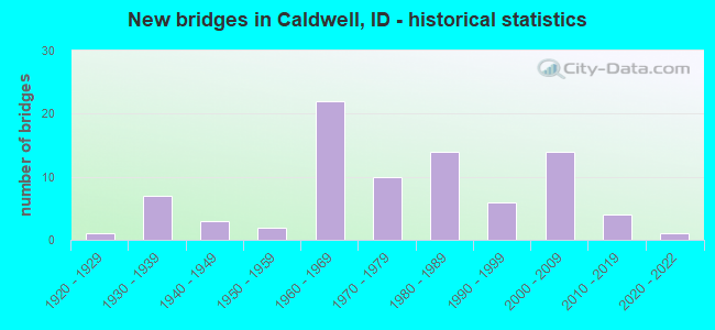
- New bridges - historical statistics
- 11920-1929
- 71930-1939
- 31940-1949
- 21950-1959
- 221960-1969
- 101970-1979
- 141980-1989
- 61990-1999
- 142000-2009
- 42010-2019
- 12020-2022

- Reconstructed bridges - Historical Statistics
- 11960-1969
- 11970-1979
- 11980-1989
- 11990-1999
- 22000-2009
- 12010-2019


- Bridge Condition - Deck
- 1.4%Excellent
- 8.7%Very good
- 30.4%Good
- 43.5%Satisfactory
- 13.0%Fair
- 2.9%Poor

- Bridge Condition - Superstructure
- 1.4%Excellent
- 15.9%Very good
- 21.7%Good
- 42.0%Satisfactory
- 11.6%Fair
- 7.2%Poor

- Bridge Condition - Substructure
- 1.4%Excellent
- 17.4%Very good
- 24.6%Good
- 36.2%Satisfactory
- 15.9%Fair
- 4.3%Poor

- Bridge Condition - Channel
- 14.1%Excellent
- 21.9%Very good
- 42.2%Good
- 18.8%Satisfactory
- 3.1%Fair

- Bridge Condition - Culverts
- 33.3%Very good
- 33.3%Good
- 33.3%Satisfactory
Find on map >> Show street view
Structure Number: 15455, Location: 3.3 W. CALDWELL (Lat: 43.735369, Lng: -116.708719), Route carried "under" structure: County highway , Year Built: 1962, Structure Length: 0. m, Average Daily Traffic: 1,300 (year 2018), Truck Traffic: 16%, Features Intersected: PURPLE SAGE GS, Facility Carried by Structure: I 84 WBL
Minimum Vertical Clearance: 4.72m (15.49ft), Kilometerpoint: 170.606, Lanes on structure: 2, Lanes under structure: 2, Material/Design: Concrete, Design/Construction: Stringer/Multi-beam, Length of Maximum Span: 10.7m (35.1ft)
Find on map >> Show street view
Structure Number: 15505, Location: IN CALDWELL;10TH AVE (Lat: 43.671056, Lng: -116.678472), Route carried "under" structure: City street 7773, Year Built: 1983, Structure Length: 0. m, Average Daily Traffic: 17,500 (year 2018), Features Intersected: STP 7773;10TH AVE IC, Facility Carried by Structure: I 84 ;US 20-26
Minimum Vertical Clearance: 5.51m (18.08ft), Kilometerpoint: 79.281, Lanes on structure: 5, Lanes under structure: 4, Material/Design: Concrete continuous, Design/Construction: Box Beam or Girders - Single/Spread, Length of Maximum Span: 39.0m (128.0ft)
Find on map >> Show street view
Structure Number: 15535, Location: IN CALDWELL;E.LINDEN RD (Lat: 43.648417, Lng: -116.650361), Route carried "under" structure: City street 7923, Year Built: 1966, Structure Length: 0. m, Average Daily Traffic: 9,100 (year 2018), Truck Traffic: 2%, Features Intersected: SMA 7923;LINDEN ROAD GS, Facility Carried by Structure: I 84 EBL
Minimum Vertical Clearance: 4.65m (15.26ft), Kilometerpoint: 14.697, Lanes on structure: 2, Lanes under structure: 2, Material/Design: Concrete, Design/Construction: Tee Beam, Length of Maximum Span: 12.3m (40.4ft)
Find on map >> Show street view
Structure Number: 1554, Location: IN CALDWELL;E.LINDEN RD (Lat: 43.648125, Lng: -116.649719), Route carried "under" structure: City street 7923, Year Built: 1966, Structure Length: 0. m, Average Daily Traffic: 9,100 (year 2018), Truck Traffic: 2%, Features Intersected: SMA 7923;LINDEN ROAD GS, Facility Carried by Structure: I 84 WBL
Minimum Vertical Clearance: 4.60m (15.09ft), Kilometerpoint: 14.734, Lanes on structure: 2, Lanes under structure: 2, Material/Design: Concrete, Design/Construction: Tee Beam, Length of Maximum Span: 12.3m (40.4ft)