Bridge Statistics for Cary, North Carolina (NC)
Condition, Traffic, Stress, Structural Evaluation, Project Costs
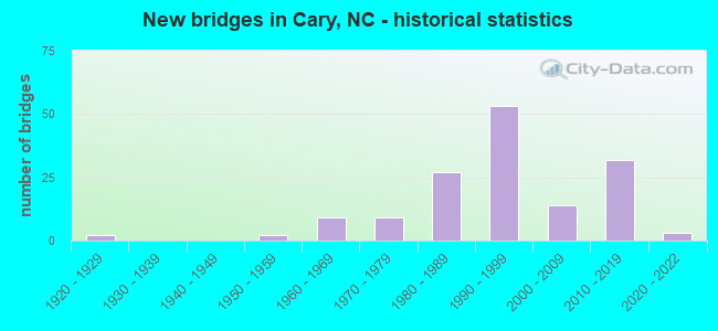
- New bridges - historical statistics
- 21920-1929
- 21950-1959
- 91960-1969
- 91970-1979
- 271980-1989
- 531990-1999
- 142000-2009
- 322010-2019
- 32020-2022

- Reconstructed bridges - Historical Statistics
- 11940-1949
- 11950-1959
- 01960-1969
- 01970-1979
- 11980-1989


- Bridge Condition - Deck
- 1.7%Excellent
- 1.7%Very good
- 57.6%Good
- 25.4%Satisfactory
- 13.6%Fair

- Bridge Condition - Superstructure
- 1.7%Excellent
- 16.9%Very good
- 47.5%Good
- 22.0%Satisfactory
- 11.9%Fair

- Bridge Condition - Substructure
- 18.6%Very good
- 54.2%Good
- 18.6%Satisfactory
- 6.8%Fair
- 1.7%Poor

- Bridge Condition - Channel
- 1.6%Very good
- 50.0%Good
- 30.6%Satisfactory
- 16.1%Fair
- 1.6%Poor

- Bridge Condition - Culverts
- 35.3%Good
- 41.2%Satisfactory
- 23.5%Fair
Find on map >> Show street view
Structure Number: 1831326, Location: 1.2 MI.W.JCT I40 (Lat: 35.864769, Lng: -78.804764), Route carried "on" structure: State highway 1002, Year Built: 1997, Status: Open, Structure Length: 4.29m (14.07ft), Average Daily Traffic: 17,000 (year 2017), Truck Traffic: 6%, Average Future Daily Traffic: 34,000 (year 2040), Design Load: HS 20+Mod, Features Intersected: SR3015
Minimum Vertical Clearance: 30+ m (98+ ft), Kilometerpoint: 0.000, Lanes on structure: 2, Lanes under structure: 3, Owner: State Highway Agency, Approaching Roadway Width: 11.5m (37.7ft), Material/Design: Prestressed concrete, Design/Construction: Segmental Box Girder, Number Of Spans In Main Unit: 1, Number Of Approach Spans: 2, Length of Maximum Span: 41.4m (135.8ft), Curb-To-Curb Width: 11.5m (37.7ft), Out-to-Out Width: 12.4m (40.7ft)
Condition: Deck: Satisfactory, Superstructure: Satisfactory, Substructure: Good, Operating Rating: 41.7 metric tons, Method Used To Determine Operating Rating: Field evaluation and documented engineering judgment, Inventory Rating: 32.6 metric tons, Method Used To Determine Inventory Rating: Field evaluation and documented engineering judgment, Structural Evaluation: Equal to present minimum criteria, Deck Geometry: Equal to present minimum criteria, Underclear: Better than present minimum criteria, Approach Roadway Alignment: Equal to present desirable criteria, Designated Inspection Frequency: Every 24 months, Inspection Date: June 2021, Deck Structure Type: Concrete Cast-file-Place, Wearing Surface/Protective System: Wearing Surface: Monolithic Concrete, Deck Protection: Epoxy Coated Reinforcing
Find on map >> Show street view
Structure Number: 1831327, Location: 1.2 MI.W.JCT.I40 (Lat: 35.864894, Lng: -78.804064), Route carried "on" structure: State highway 1002, Year Built: 1962, Status: Open, Structure Length: 4.54m (14.90ft), Average Daily Traffic: 18,000 (year 2017), Truck Traffic: 6%, Average Future Daily Traffic: 36,000 (year 2040), Design Load: HS 20+Mod, Features Intersected: SR 3015
Minimum Vertical Clearance: 30+ m (98+ ft), Kilometerpoint: 0.000, Lanes on structure: 2, Lanes under structure: 3, Owner: State Highway Agency, Approaching Roadway Width: 11.2m (36.7ft), Skew: 2 degrees, Material/Design: Prestressed concrete, Design/Construction: Segmental Box Girder, Number Of Spans In Main Unit: 1, Length of Maximum Span: 43.8m (143.7ft), Curb-To-Curb Width: 15.2m (49.9ft), Out-to-Out Width: 16.1m (52.8ft)
Condition: Deck: Satisfactory, Superstructure: Satisfactory, Substructure: Good, Operating Rating: 89.8 metric tons, Method Used To Determine Operating Rating: Load Factor (LF), Inventory Rating: 63.5 metric tons, Method Used To Determine Inventory Rating: Load Factor (LF), Structural Evaluation: Equal to present minimum criteria, Deck Geometry: Superior to present desirable criteria, Underclear: Better than present minimum criteria, Approach Roadway Alignment: Equal to present desirable criteria, Designated Inspection Frequency: Every 24 months, Inspection Date: June 2021, Deck Structure Type: Concrete Cast-file-Place, Wearing Surface/Protective System: Wearing Surface: Monolithic Concrete, Deck Protection: Epoxy Coated Reinforcing
Find on map >> Show street view
Structure Number: 1831328, Location: 1.1 MI.E JCT SR1642 (Lat: 35.866158, Lng: -78.803944), Route carried "on" structure: Ramp State highway 1002, Year Built: 1997, Status: Open, Structure Length: 5.30m (17.39ft), Average Daily Traffic: 8,500 (year 2017), Truck Traffic: 12%, Average Future Daily Traffic: 17,000 (year 2040), Design Load: HS 20+Mod, Features Intersected: SR1002 N
Minimum Vertical Clearance: 30+ m (98+ ft), Kilometerpoint: 0.000, Lanes on structure: 2, Lanes under structure: 3, Owner: State Highway Agency, Approaching Roadway Width: 11.5m (37.7ft), Skew: 2 degrees, Material/Design: Prestressed concrete, Design/Construction: Segmental Box Girder, Number Of Spans In Main Unit: 1, Length of Maximum Span: 51.5m (169.0ft), Curb-To-Curb Width: 12.1m (39.7ft), Out-to-Out Width: 13.0m (42.7ft)
Condition: Deck: Satisfactory, Superstructure: Satisfactory, Substructure: Good, Operating Rating: 89.8 metric tons, Method Used To Determine Operating Rating: Load Factor (LF), Inventory Rating: 87.0 metric tons, Method Used To Determine Inventory Rating: Load Factor (LF), Structural Evaluation: Equal to present minimum criteria, Deck Geometry: Superior to present desirable criteria, Underclear: Better than present minimum criteria, Approach Roadway Alignment: Equal to present desirable criteria, Designated Inspection Frequency: Every 24 months, Inspection Date: June 2021, Deck Structure Type: Concrete Cast-file-Place, Wearing Surface/Protective System: Wearing Surface: Monolithic Concrete, Deck Protection: Epoxy Coated Reinforcing
Find on map >> Show street view
Structure Number: 1831329, Location: 1.38 MI.W.JCT.I40 (Lat: 35.866633, Lng: -78.805142), Route carried "on" structure: State highway 1002, Year Built: 1997, Status: Open, Structure Length: 5.76m (18.90ft), Average Daily Traffic: 17,000 (year 2017), Truck Traffic: 6%, Average Future Daily Traffic: 34,000 (year 2040), Design Load: HS 20+Mod, Features Intersected: SR3015W
Minimum Vertical Clearance: 30+ m (98+ ft), Kilometerpoint: 0.000, Lanes on structure: 2, Lanes under structure: 4, Owner: State Highway Agency, Approaching Roadway Width: 11.2m (36.7ft), Skew: 4 degrees, Material/Design: Prestressed concrete, Design/Construction: Segmental Box Girder, Number Of Spans In Main Unit: 1, Length of Maximum Span: 56.0m (183.7ft), Curb-To-Curb Width: 11.5m (37.7ft), Out-to-Out Width: 12.4m (40.7ft)
Condition: Deck: Satisfactory, Superstructure: Satisfactory, Substructure: Good, Operating Rating: 85.2 metric tons, Method Used To Determine Operating Rating: Load Factor (LF), Inventory Rating: 39.0 metric tons, Method Used To Determine Inventory Rating: Load Factor (LF), Structural Evaluation: Equal to present minimum criteria, Deck Geometry: Equal to present minimum criteria, Underclear: Equal to present minimum criteria, Approach Roadway Alignment: Equal to present desirable criteria, Designated Inspection Frequency: Every 24 months, Inspection Date: June 2021, Deck Structure Type: Concrete Cast-file-Place, Wearing Surface/Protective System: Wearing Surface: Monolithic Concrete, Deck Protection: Epoxy Coated Reinforcing
Find on map >> Show street view
Structure Number: 183133, Location: 1.07 MI.E.JCT.SR1642 (Lat: 35.866931, Lng: -78.804772), Route carried "on" structure: Ramp State highway 1002, Year Built: 1997, Status: Open, Structure Length: 5.88m (19.29ft), Average Daily Traffic: 9,000 (year 2015), Truck Traffic: 12%, Average Future Daily Traffic: 18,000 (year 2040), Design Load: HS 20+Mod, Features Intersected: SR3015
Minimum Vertical Clearance: 30+ m (98+ ft), Kilometerpoint: 0.000, Lanes on structure: 2, Lanes under structure: 3, Base Highway Network: Yes, Owner: State Highway Agency, Approaching Roadway Width: 11.8m (38.7ft), Skew: 1 degrees, Material/Design: Prestressed concrete, Design/Construction: Segmental Box Girder, Number Of Spans In Main Unit: 1, Length of Maximum Span: 57.3m (188.0ft), Curb-To-Curb Width: 12.1m (39.7ft), Out-to-Out Width: 13.0m (42.7ft)
Condition: Deck: Satisfactory, Superstructure: Satisfactory, Substructure: Good, Operating Rating: 89.8 metric tons, Method Used To Determine Operating Rating: Load Factor (LF), Inventory Rating: 84.3 metric tons, Method Used To Determine Inventory Rating: Load Factor (LF), Structural Evaluation: Equal to present minimum criteria, Deck Geometry: Superior to present desirable criteria, Underclear: Equal to present minimum criteria, Approach Roadway Alignment: Equal to present desirable criteria, Designated Inspection Frequency: Every 24 months, Inspection Date: June 2021, Deck Structure Type: Concrete Cast-file-Place, Wearing Surface/Protective System: Wearing Surface: Monolithic Concrete, Deck Protection: Epoxy Coated Reinforcing
Find on map >> Show street view
Structure Number: 1831331, Location: 1.38 MI W. JCT I-40 (Lat: 35.867458, Lng: -78.804111), Route carried "on" structure: State highway 1002, Year Built: 1962, Status: Open, Structure Length: 4.93m (16.17ft), Average Daily Traffic: 17,000 (year 2017), Truck Traffic: 6%, Average Future Daily Traffic: 34,000 (year 2040), Design Load: HS 20+Mod, Features Intersected: SR3015 WBL
Minimum Vertical Clearance: 30+ m (98+ ft), Kilometerpoint: 0.000, Lanes on structure: 3, Lanes under structure: 3, Owner: State Highway Agency, Approaching Roadway Width: 12.8m (42.0ft), Skew: 2 degrees, Material/Design: Prestressed concrete, Design/Construction: Segmental Box Girder, Number Of Spans In Main Unit: 1, Length of Maximum Span: 47.8m (156.8ft), Curb-To-Curb Width: 16.4m (53.8ft), Out-to-Out Width: 17.3m (56.8ft)
Condition: Deck: Satisfactory, Superstructure: Satisfactory, Substructure: Good, Operating Rating: 89.8 metric tons, Method Used To Determine Operating Rating: Load Factor (LF), Inventory Rating: 87.0 metric tons, Method Used To Determine Inventory Rating: Load Factor (LF), Structural Evaluation: Equal to present minimum criteria, Deck Geometry: Better than present minimum criteria, Underclear: Equal to present minimum criteria, Approach Roadway Alignment: Equal to present desirable criteria, Designated Inspection Frequency: Every 24 months, Inspection Date: June 2021, Deck Structure Type: Concrete Cast-file-Place, Wearing Surface/Protective System: Wearing Surface: Monolithic Concrete, Deck Protection: Epoxy Coated Reinforcing
Find on map >> Show street view
Structure Number: 1831478, Location: 0.03MI.N.OF ANGELICA CRL (Lat: 35.727806, Lng: -78.803722), Route carried "on" structure: City street , Year Built: 2005, Status: Open, Structure Length: 0.73m (2.40ft), Average Daily Traffic: 100 (year 2015), Truck Traffic: 7%, Average Future Daily Traffic: 200 (year 2040), Design Load: HS 20+Mod, Features Intersected: SWIFT CREEK, Facility Carried by Structure: REGENCY PARKWAY
Minimum Vertical Clearance: 30+ m (98+ ft), Kilometerpoint: 0.000, Lanes on structure: 2, Owner: City or Municipal Highway Agency, Approaching Roadway Width: 10.6m (34.8ft), Skew: 3 degrees, Material/Design: Concrete continuous, Design/Construction: Culvert, Number Of Spans In Main Unit: 2, Length of Maximum Span: 3.0m (9.8ft)
Condition: Channel: Satisfactory, Culverts: Satisfactory, Operating Rating: 58.0 metric tons, Method Used To Determine Operating Rating: Load Factor (LF), Inventory Rating: 45.3 metric tons, Method Used To Determine Inventory Rating: Load Factor (LF), Structural Evaluation: Equal to present minimum criteria, Waterway Adequacy: Better than present minimum criteria, Approach Roadway Alignment: Equal to present desirable criteria, Designated Inspection Frequency: Every 24 months, Inspection Date: March 2020
Find on map >> Show street view
Structure Number: 1831584, Location: 400 FT.E.JCT.GROGANS MILL (Lat: 35.808503, Lng: -78.908125), Route carried "on" structure: City street , Year Built: 2019, Status: Open, Structure Length: 0.64m (2.10ft), Average Daily Traffic: 100 (year 2019), Truck Traffic: 7%, Average Future Daily Traffic: 200 (year 2040), Design Load: HS 20, Features Intersected: CREEK, Facility Carried by Structure: LANTERN RIDGE LN.
Minimum Vertical Clearance: 30+ m (98+ ft), Kilometerpoint: 0.000, Lanes on structure: 2, Owner: City or Municipal Highway Agency, Approaching Roadway Width: 8.2m (26.9ft), Material/Design: Aluminum, Iron, Design/Construction: Culvert, Number Of Spans In Main Unit: 1, Length of Maximum Span: 6.4m (21.0ft), Curb or Sidewalk Widths: Left: 1.5m (4.9ft), Right: 1.5m (4.9ft)
Condition: Channel: Satisfactory, Culverts: Good, Operating Rating: 89.8 metric tons, Method Used To Determine Operating Rating: Load and Resistance Factor (LRFR), Inventory Rating: 89.8 metric tons, Method Used To Determine Inventory Rating: Load and Resistance Factor (LRFR), Structural Evaluation: Better than present minimum criteria, Waterway Adequacy: Better than present minimum criteria, Approach Roadway Alignment: Equal to present desirable criteria, Designated Inspection Frequency: Every 24 months, Inspection Date: March 2022
Find on map >> Show street view
Structure Number: 1830037, Location: 0.15 MI. S. JCT SR1789 (Lat: 35.861272, Lng: -78.814850), Route carried "under" structure: Interstate 40, Year Built: 1971, Structure Length: 0. m, Average Daily Traffic: 81,000 (year 2017), Truck Traffic: 16%, Features Intersected: SR3015
Minimum Vertical Clearance: 5.43m (17.81ft), Kilometerpoint: 86.564, Lanes on structure: 4, Lanes under structure: 4, Material/Design: Steel continuous, Design/Construction: Stringer/Multi-beam, Length of Maximum Span: 28.9m (94.8ft)
Find on map >> Show street view
Structure Number: 1830037, Location: 0.15 MI. S. JCT SR1789 (Lat: 35.861272, Lng: -78.814850), Route carried "under" structure: Interstate 40, Year Built: 1971, Structure Length: 0. m, Average Daily Traffic: 81,000 (year 2017), Truck Traffic: 16%, Features Intersected: SR3015
Minimum Vertical Clearance: 5.74m (18.83ft), Kilometerpoint: 86.564, Lanes on structure: 4, Lanes under structure: 4, Material/Design: Steel continuous, Design/Construction: Stringer/Multi-beam, Length of Maximum Span: 28.9m (94.8ft)
Find on map >> Show street view
Structure Number: 1830073, Location: 1.5 MI. N. JCT. SR1653 (Lat: 35.850125, Lng: -78.798561), Route carried "under" structure: Interstate 40, Year Built: 2020, Structure Length: 0. m, Average Daily Traffic: 76,500 (year 2018), Truck Traffic: 16%, Features Intersected: SR1002
Minimum Vertical Clearance: 6.45m (21.16ft), Kilometerpoint: 0.000, Lanes on structure: 4, Lanes under structure: 5, Material/Design: Steel continuous, Design/Construction: Stringer/Multi-beam, Length of Maximum Span: 46.6m (152.9ft)
Find on map >> Show street view
Structure Number: 1830073, Location: 1.5 MI. N. JCT. SR1653 (Lat: 35.850125, Lng: -78.798561), Route carried "under" structure: Interstate 40, Year Built: 2020, Structure Length: 0. m, Average Daily Traffic: 76,500 (year 2018), Truck Traffic: 16%, Features Intersected: SR1002
Minimum Vertical Clearance: 7.16m (23.49ft), Kilometerpoint: 0.000, Lanes on structure: 4, Lanes under structure: 4, Material/Design: Steel continuous, Design/Construction: Stringer/Multi-beam, Length of Maximum Span: 46.6m (152.9ft)
Find on map >> Show street view
Structure Number: 1830101, Location: 0.7 MI. N. OF JCT. SR3090 (Lat: 35.840208, Lng: -78.781775), Route carried "under" structure: Interstate 40, Year Built: 1969, Structure Length: 0. m, Average Daily Traffic: 83,500 (year 2015), Truck Traffic: 23%, Features Intersected: SR1795
Minimum Vertical Clearance: 5.33m (17.49ft), Kilometerpoint: 87.173, Lanes on structure: 2, Lanes under structure: 4, Material/Design: Steel, Design/Construction: Stringer/Multi-beam, Length of Maximum Span: 28.3m (92.8ft)
Find on map >> Show street view
Structure Number: 1830101, Location: 0.7 MI. N. OF JCT. SR3090 (Lat: 35.840208, Lng: -78.781775), Route carried "under" structure: Interstate 40, Year Built: 1969, Structure Length: 0. m, Average Daily Traffic: 783,500 (year 2015), Truck Traffic: 23%, Features Intersected: SR1795
Minimum Vertical Clearance: 6.70m (21.98ft), Kilometerpoint: 87.173, Lanes on structure: 2, Lanes under structure: 4, Material/Design: Steel, Design/Construction: Stringer/Multi-beam, Length of Maximum Span: 28.3m (92.8ft)
Find on map >> Show street view
Structure Number: 1830167, Location: 0.8MI S. JCT SR1300 (Lat: 35.737272, Lng: -78.793136), Route carried "under" structure: US 64, Year Built: 1993, Structure Length: 0. m, Average Daily Traffic: 26,750 (year 2019), Truck Traffic: 12%, Features Intersected: US1 SBL
Minimum Vertical Clearance: 5.27m (17.29ft), Kilometerpoint: 0.000, Lanes on structure: 3, Lanes under structure: 4, Material/Design: Steel continuous, Design/Construction: Stringer/Multi-beam, Length of Maximum Span: 48.1m (157.8ft)
Find on map >> Show street view
Structure Number: 1830167, Location: 0.8MI S. JCT SR1300 (Lat: 35.737272, Lng: -78.793136), Route carried "under" structure: US 64, Year Built: 1993, Structure Length: 0. m, Average Daily Traffic: 26,750 (year 2019), Truck Traffic: 12%, Features Intersected: US1 SBL
Minimum Vertical Clearance: 5.45m (17.88ft), Kilometerpoint: 0.000, Lanes on structure: 3, Lanes under structure: 5, Material/Design: Steel continuous, Design/Construction: Stringer/Multi-beam, Length of Maximum Span: 48.1m (157.8ft)
Find on map >> Show street view
Structure Number: 1830171, Location: 0.3 MI.N. JCT. SR1009 (Lat: 35.743544, Lng: -78.781119), Route carried "under" structure: US 1, Year Built: 1991, Structure Length: 0. m, Average Daily Traffic: 55,000 (year 2019), Truck Traffic: 12%, Features Intersected: SR1300
Minimum Vertical Clearance: 5.73m (18.80ft), Kilometerpoint: 0.000, Lanes on structure: 5, Lanes under structure: 4, Material/Design: Steel, Design/Construction: Stringer/Multi-beam, Length of Maximum Span: 35.6m (116.8ft)
Find on map >> Show street view
Structure Number: 1830171, Location: 0.3 MI.N. JCT. SR1009 (Lat: 35.743544, Lng: -78.781119), Route carried "under" structure: US 1, Year Built: 1991, Structure Length: 0. m, Average Daily Traffic: 55,000 (year 2019), Truck Traffic: 12%, Features Intersected: SR1300
Minimum Vertical Clearance: 5.91m (19.39ft), Kilometerpoint: 0.000, Lanes on structure: 5, Lanes under structure: 4, Material/Design: Steel, Design/Construction: Stringer/Multi-beam, Length of Maximum Span: 35.6m (116.8ft)
Find on map >> Show street view
Structure Number: 1830178, Location: 100 FT. E. JCT. SR1315 (Lat: 35.761942, Lng: -78.744900), Route carried "under" structure: US 1, Year Built: 1980, Structure Length: 0. m, Average Daily Traffic: 74,500 (year 2019), Truck Traffic: 12%, Features Intersected: SR1313
Minimum Vertical Clearance: 5.33m (17.49ft), Kilometerpoint: 0.000, Lanes on structure: 6, Lanes under structure: 4, Material/Design: Steel, Design/Construction: Stringer/Multi-beam, Length of Maximum Span: 27.1m (88.9ft)
Find on map >> Show street view
Structure Number: 1830178, Location: 100 FT. E. JCT. SR1315 (Lat: 35.761942, Lng: -78.744900), Route carried "under" structure: Ramp US 1, Year Built: 1980, Structure Length: 0. m, Average Daily Traffic: 37,250 (year 2019), Truck Traffic: 12%, Features Intersected: SR1313
Minimum Vertical Clearance: 5.25m (17.22ft), Kilometerpoint: 0.000, Lanes on structure: 6, Lanes under structure: 2, Material/Design: Steel, Design/Construction: Stringer/Multi-beam, Length of Maximum Span: 27.1m (88.9ft)
Find on map >> Show street view
Structure Number: 1830178, Location: 100 FT. E. JCT. SR1315 (Lat: 35.761942, Lng: -78.744900), Route carried "under" structure: US 1, Year Built: 1980, Structure Length: 0. m, Average Daily Traffic: 74,500 (year 2019), Truck Traffic: 12%, Features Intersected: SR1313
Minimum Vertical Clearance: 5.13m (16.83ft), Kilometerpoint: 0.000, Lanes on structure: 6, Lanes under structure: 2, Material/Design: Steel, Design/Construction: Stringer/Multi-beam, Length of Maximum Span: 27.1m (88.9ft)
Find on map >> Show street view
Structure Number: 1830635, Location: 1.6 MI. E. JCT. SR1300 (Lat: 35.748556, Lng: -78.771814), Route carried "under" structure: US 1, Year Built: 1987, Structure Length: 0. m, Average Daily Traffic: 52,000 (year 2018), Truck Traffic: 12%, Features Intersected: SR3977
Minimum Vertical Clearance: 5.00m (16.40ft), Kilometerpoint: 0.000, Lanes on structure: 6, Lanes under structure: 4, Material/Design: Steel, Design/Construction: Stringer/Multi-beam, Length of Maximum Span: 32.3m (106.0ft)
Find on map >> Show street view
Structure Number: 1830635, Location: 1.6 MI. E. JCT. SR1300 (Lat: 35.748556, Lng: -78.771814), Route carried "under" structure: US 1, Year Built: 1987, Structure Length: 0. m, Average Daily Traffic: 52,000 (year 2018), Truck Traffic: 12%, Features Intersected: SR3977
Minimum Vertical Clearance: 5.02m (16.47ft), Kilometerpoint: 0.000, Lanes on structure: 6, Lanes under structure: 4, Material/Design: Steel, Design/Construction: Stringer/Multi-beam, Length of Maximum Span: 32.3m (106.0ft)
Find on map >> Show street view
Structure Number: 1830649, Location: 0.1 MI. W JCT SR1313 (Lat: 35.762061, Lng: -78.744656), Route carried "under" structure: US 1, Year Built: 1989, Structure Length: 0. m, Average Daily Traffic: 49,667 (year 2019), Truck Traffic: 12%, Features Intersected: 9905 CROSSRD BLV R
Minimum Vertical Clearance: 5.69m (18.67ft), Kilometerpoint: 0.000, Lanes on structure: 2, Lanes under structure: 2, Material/Design: Steel continuous, Design/Construction: Stringer/Multi-beam, Length of Maximum Span: 33.5m (109.9ft)
Find on map >> Show street view
Structure Number: 1830649, Location: 0.1 MI. W JCT SR1313 (Lat: 35.762061, Lng: -78.744656), Route carried "under" structure: Ramp US 1, Year Built: 1989, Structure Length: 0. m, Average Daily Traffic: 49,667 (year 2019), Truck Traffic: 7%, Features Intersected: 9905 CROSSRD BLV R
Minimum Vertical Clearance: 5.33m (17.49ft), Kilometerpoint: 0.000, Lanes on structure: 2, Lanes under structure: 2, Material/Design: Steel continuous, Design/Construction: Stringer/Multi-beam, Length of Maximum Span: 33.5m (109.9ft)
Find on map >> Show street view
Structure Number: 1830649, Location: 0.1 MI. W JCT SR1313 (Lat: 35.762061, Lng: -78.744656), Route carried "under" structure: US 1, Year Built: 1989, Structure Length: 0. m, Average Daily Traffic: 49,667 (year 2019), Truck Traffic: 12%, Features Intersected: 9905 CROSSRD BLV R
Minimum Vertical Clearance: 5.73m (18.80ft), Kilometerpoint: 0.000, Lanes on structure: 2, Lanes under structure: 4, Material/Design: Steel continuous, Design/Construction: Stringer/Multi-beam, Length of Maximum Span: 33.5m (109.9ft)
Find on map >> Show street view
Structure Number: 1830663, Location: 0.1 MI.N. JCT. SR1009 (Lat: 35.737194, Lng: -78.792878), Route carried "under" structure: US 64, Year Built: 1993, Structure Length: 0. m, Average Daily Traffic: 26,750 (year 2019), Truck Traffic: 12%, Features Intersected: US1 NBL
Minimum Vertical Clearance: 5.28m (17.32ft), Kilometerpoint: 0.000, Lanes on structure: 2, Lanes under structure: 4, Material/Design: Steel continuous, Design/Construction: Stringer/Multi-beam, Length of Maximum Span: 49.3m (161.7ft)
Find on map >> Show street view
Structure Number: 1830663, Location: 0.1 MI.N. JCT. SR1009 (Lat: 35.737194, Lng: -78.792878), Route carried "under" structure: US 64, Year Built: 1993, Structure Length: 0. m, Average Daily Traffic: 26,750 (year 2019), Truck Traffic: 12%, Features Intersected: US1 NBL
Minimum Vertical Clearance: 5.36m (17.59ft), Kilometerpoint: 0.000, Lanes on structure: 2, Lanes under structure: 5, Material/Design: Steel continuous, Design/Construction: Stringer/Multi-beam, Length of Maximum Span: 49.3m (161.7ft)
Find on map >> Show street view
Structure Number: 1830664, Location: 0.12 MI. W. JCT. SR1300 (Lat: 35.737114, Lng: -78.789014), Route carried "under" structure: Ramp US 64, Year Built: 1993, Structure Length: 0. m, Average Daily Traffic: 36,666 (year 2019), Truck Traffic: 12%, Features Intersected: SR1009W
Minimum Vertical Clearance: 5.10m (16.73ft), Kilometerpoint: 0.000, Lanes on structure: 2, Lanes under structure: 1, Material/Design: Steel, Design/Construction: Stringer/Multi-beam, Length of Maximum Span: 47.2m (154.9ft)
Find on map >> Show street view
Structure Number: 1830756, Location: 1.3 MI.N.JCT.SR1792 (Lat: 35.887333, Lng: -78.818411), Route carried "under" structure: Interstate 540, Year Built: 1998, Structure Length: 0. m, Average Daily Traffic: 23,500 (year 2018), Truck Traffic: 23%, Features Intersected: SR1789
Minimum Vertical Clearance: 6.37m (20.90ft), Kilometerpoint: 0.000, Lanes on structure: 5, Lanes under structure: 3, Material/Design: Steel continuous, Design/Construction: Stringer/Multi-beam, Length of Maximum Span: 47.2m (154.9ft)
Find on map >> Show street view
Structure Number: 1830756, Location: 1.3 MI.N.JCT.SR1792 (Lat: 35.887333, Lng: -78.818411), Route carried "under" structure: Ramp Interstate 540, Year Built: 1998, Structure Length: 0. m, Average Daily Traffic: 23,500 (year 2018), Truck Traffic: 16%, Features Intersected: SR1789
Minimum Vertical Clearance: 6.79m (22.28ft), Kilometerpoint: 0.000, Lanes on structure: 5, Lanes under structure: 2, Material/Design: Steel continuous, Design/Construction: Stringer/Multi-beam, Length of Maximum Span: 47.2m (154.9ft)
Find on map >> Show street view
Structure Number: 1830756, Location: 1.3 MI.N.JCT.SR1792 (Lat: 35.887333, Lng: -78.818411), Route carried "under" structure: Interstate 540, Year Built: 1998, Structure Length: 0. m, Average Daily Traffic: 23,500 (year 2018), Truck Traffic: 23%, Features Intersected: SR1789
Minimum Vertical Clearance: 5.66m (18.57ft), Kilometerpoint: 0.000, Lanes on structure: 5, Lanes under structure: 4, Material/Design: Steel continuous, Design/Construction: Stringer/Multi-beam, Length of Maximum Span: 47.2m (154.9ft)
Find on map >> Show street view
Structure Number: 1830757, Location: 0.3.MI. N. OF I540 S (Lat: 35.890136, Lng: -78.815928), Route carried "under" structure: Ramp Interstate 540, Year Built: 1998, Structure Length: 0. m, Average Daily Traffic: 18,500 (year 2013), Truck Traffic: 16%, Features Intersected: SR3097 RAMP E
Minimum Vertical Clearance: 5.51m (18.08ft), Kilometerpoint: 0.000, Lanes on structure: 2, Lanes under structure: 1, Material/Design: Steel continuous, Design/Construction: Stringer/Multi-beam, Length of Maximum Span: 49.0m (160.8ft)
Find on map >> Show street view
Structure Number: 1830757, Location: 0.3.MI. N. OF I540 S (Lat: 35.890136, Lng: -78.815928), Route carried "under" structure: Ramp Interstate 540, Year Built: 1998, Structure Length: 0. m, Average Daily Traffic: 18,500 (year 2013), Truck Traffic: 16%, Features Intersected: SR3097 RAMP E
Minimum Vertical Clearance: 5.36m (17.59ft), Kilometerpoint: 0.000, Lanes on structure: 2, Lanes under structure: 1, Material/Design: Steel continuous, Design/Construction: Stringer/Multi-beam, Length of Maximum Span: 49.0m (160.8ft)
Find on map >> Show street view
Structure Number: 1830757, Location: 0.3.MI. N. OF I540 S (Lat: 35.890136, Lng: -78.815928), Route carried "under" structure: Interstate 540, Year Built: 1998, Structure Length: 0. m, Average Daily Traffic: 37,000 (year 2013), Truck Traffic: 16%, Features Intersected: SR3097 RAMP E
Minimum Vertical Clearance: 6.12m (20.08ft), Kilometerpoint: 0.426, Lanes on structure: 2, Lanes under structure: 4, Material/Design: Steel continuous, Design/Construction: Stringer/Multi-beam, Length of Maximum Span: 49.0m (160.8ft)
Find on map >> Show street view
Structure Number: 1830757, Location: 0.3.MI. N. OF I540 S (Lat: 35.890136, Lng: -78.815928), Route carried "under" structure: Interstate 540, Year Built: 1998, Structure Length: 0. m, Average Daily Traffic: 37,000 (year 2013), Truck Traffic: 16%, Features Intersected: SR3097 RAMP E
Minimum Vertical Clearance: 5.94m (19.49ft), Kilometerpoint: 0.426, Lanes on structure: 2, Lanes under structure: 3, Material/Design: Steel continuous, Design/Construction: Stringer/Multi-beam, Length of Maximum Span: 49.0m (160.8ft)
Find on map >> Show street view
Structure Number: 1830758, Location: 0.7 MI.S.SR1644 (Lat: 35.891897, Lng: -78.813617), Route carried "under" structure: Interstate 540, Year Built: 1998, Structure Length: 0. m, Average Daily Traffic: 23,500 (year 2018), Truck Traffic: 23%, Features Intersected: SR3097 NB
Minimum Vertical Clearance: 6.06m (19.88ft), Kilometerpoint: 0.457, Lanes on structure: 3, Lanes under structure: 3, Material/Design: Steel continuous, Design/Construction: Stringer/Multi-beam, Length of Maximum Span: 53.3m (174.9ft)
Find on map >> Show street view
Structure Number: 1830758, Location: 0.7 MI.S.SR1644 (Lat: 35.891897, Lng: -78.813617), Route carried "under" structure: Ramp Interstate 540, Year Built: 1998, Structure Length: 0. m, Average Daily Traffic: 23,500 (year 2018), Truck Traffic: 23%, Features Intersected: SR3097 NB
Minimum Vertical Clearance: 5.91m (19.39ft), Kilometerpoint: 0.000, Lanes on structure: 3, Lanes under structure: 2, Material/Design: Steel continuous, Design/Construction: Stringer/Multi-beam, Length of Maximum Span: 53.3m (174.9ft)
Find on map >> Show street view
Structure Number: 1830758, Location: 0.7 MI.S.SR1644 (Lat: 35.891897, Lng: -78.813617), Route carried "under" structure: Interstate 540, Year Built: 1998, Structure Length: 0. m, Average Daily Traffic: 23,500 (year 2018), Truck Traffic: 23%, Features Intersected: SR3097 NB
Minimum Vertical Clearance: 5.82m (19.09ft), Kilometerpoint: 0.457, Lanes on structure: 3, Lanes under structure: 4, Material/Design: Steel continuous, Design/Construction: Stringer/Multi-beam, Length of Maximum Span: 53.3m (174.9ft)
Find on map >> Show street view
Structure Number: 1830942, Location: 0.3 E. OF JCT. SR 1789 (Lat: 35.882950, Lng: -78.810058), Route carried "under" structure: State highway 3097, Year Built: 1999, Structure Length: 0. m, Average Daily Traffic: 7,000 (year 2011), Truck Traffic: 12%, Features Intersected: SR1642
Minimum Vertical Clearance: 5.13m (16.83ft), Kilometerpoint: 0.000, Lanes on structure: 2, Lanes under structure: 2, Material/Design: Steel continuous, Design/Construction: Stringer/Multi-beam, Length of Maximum Span: 35.9m (117.8ft)
Find on map >> Show street view
Structure Number: 1830942, Location: 0.3 E. OF JCT. SR 1789 (Lat: 35.882950, Lng: -78.810058), Route carried "under" structure: State highway 3097, Year Built: 1999, Structure Length: 0. m, Average Daily Traffic: 7,000 (year 2011), Truck Traffic: 12%, Features Intersected: SR1642
Minimum Vertical Clearance: 6.57m (21.56ft), Kilometerpoint: 0.000, Lanes on structure: 2, Lanes under structure: 3, Material/Design: Steel continuous, Design/Construction: Stringer/Multi-beam, Length of Maximum Span: 35.9m (117.8ft)
Find on map >> Show street view
Structure Number: 1831017, Location: @ JCT.NC55 (Lat: 35.840836, Lng: -78.886556), Route carried "under" structure: State highway 55, Year Built: 2007, Structure Length: 0. m, Average Daily Traffic: 13,000 (year 2018), Truck Traffic: 14%, Features Intersected: NC540 W TOLL
Minimum Vertical Clearance: 6.19m (20.31ft), Kilometerpoint: 0.000, Lanes on structure: 4, Lanes under structure: 4, Material/Design: Prestressed concrete continuous, Design/Construction: Stringer/Multi-beam, Length of Maximum Span: 32.3m (106.0ft)
Find on map >> Show street view
Structure Number: 1831017, Location: @ JCT.NC55 (Lat: 35.840836, Lng: -78.886556), Route carried "under" structure: State highway 55, Year Built: 2007, Structure Length: 0. m, Average Daily Traffic: 13,000 (year 2018), Truck Traffic: 14%, Features Intersected: NC540 W TOLL
Minimum Vertical Clearance: 6.09m (19.98ft), Kilometerpoint: 0.000, Lanes on structure: 4, Lanes under structure: 3, Material/Design: Prestressed concrete continuous, Design/Construction: Stringer/Multi-beam, Length of Maximum Span: 32.3m (106.0ft)
Find on map >> Show street view
Structure Number: 1831018, Location: @ JCT.NC55 (Lat: 35.840622, Lng: -78.886375), Route carried "under" structure: State highway 55, Year Built: 2007, Structure Length: 0. m, Average Daily Traffic: 13,000 (year 2018), Truck Traffic: 12%, Features Intersected: NC540 E TOLL
Minimum Vertical Clearance: 5.56m (18.24ft), Kilometerpoint: 0.000, Lanes on structure: 4, Lanes under structure: 4, Material/Design: Prestressed concrete continuous, Design/Construction: Stringer/Multi-beam, Length of Maximum Span: 32.3m (106.0ft)
Find on map >> Show street view
Structure Number: 1831018, Location: @ JCT.NC55 (Lat: 35.840622, Lng: -78.886375), Route carried "under" structure: State highway 55, Year Built: 2007, Structure Length: 0. m, Average Daily Traffic: 13,000 (year 2018), Truck Traffic: 12%, Features Intersected: NC540 E TOLL
Minimum Vertical Clearance: 5.38m (17.65ft), Kilometerpoint: 0.000, Lanes on structure: 4, Lanes under structure: 3, Material/Design: Prestressed concrete continuous, Design/Construction: Stringer/Multi-beam, Length of Maximum Span: 32.3m (106.0ft)
Find on map >> Show street view
Structure Number: 18313, Location: @ JCT.NC540 (Lat: 35.782817, Lng: -78.887361), Route carried "under" structure: ServiceState highway 540, Year Built: 2011, Structure Length: 0. m, Average Daily Traffic: 18,000 (year 2019), Truck Traffic: 12%, Features Intersected: SR1615
Minimum Vertical Clearance: 5.86m (19.23ft), Kilometerpoint: 0.000, Lanes on structure: 6, Lanes under structure: 4, Material/Design: Prestressed concrete continuous, Design/Construction: Stringer/Multi-beam, Length of Maximum Span: 31.0m (101.7ft)
Find on map >> Show street view
Structure Number: 18313, Location: @ JCT.NC540 (Lat: 35.782817, Lng: -78.887361), Route carried "under" structure: ServiceState highway 540, Year Built: 2011, Structure Length: 0. m, Average Daily Traffic: 18,000 (year 2019), Truck Traffic: 12%, Features Intersected: SR1615
Minimum Vertical Clearance: 5.41m (17.75ft), Kilometerpoint: 0.000, Lanes on structure: 6, Lanes under structure: 4, Material/Design: Prestressed concrete continuous, Design/Construction: Stringer/Multi-beam, Length of Maximum Span: 31.0m (101.7ft)
Find on map >> Show street view
Structure Number: 1831301, Location: 0.5 MI.E.JCT.SR1600 (Lat: 35.803281, Lng: -78.891225), Route carried "under" structure: State highway 540, Year Built: 2011, Structure Length: 0. m, Average Daily Traffic: 18,000 (year 2019), Truck Traffic: 12%, Features Intersected: SR1621
Minimum Vertical Clearance: 5.43m (17.81ft), Kilometerpoint: 1921.635, Lanes on structure: 2, Lanes under structure: 3, Material/Design: Prestressed concrete, Design/Construction: Stringer/Multi-beam, Length of Maximum Span: 40.2m (131.9ft)
Find on map >> Show street view
Structure Number: 1831301, Location: 0.5 MI.E.JCT.SR1600 (Lat: 35.803281, Lng: -78.891225), Route carried "under" structure: State highway 540, Year Built: 2011, Structure Length: 0. m, Average Daily Traffic: 18,000 (year 2019), Truck Traffic: 12%, Features Intersected: SR1621
Minimum Vertical Clearance: 5.48m (17.98ft), Kilometerpoint: 19.339, Lanes on structure: 2, Lanes under structure: 3, Material/Design: Prestressed concrete, Design/Construction: Stringer/Multi-beam, Length of Maximum Span: 40.2m (131.9ft)
Find on map >> Show street view
Structure Number: 1831302, Location: 4.5 MI.N.JCT US64 (Lat: 35.809156, Lng: -78.892097), Route carried "under" structure: ServiceState highway 540, Year Built: 2012, Structure Length: 0. m, Average Daily Traffic: 11,500 (year 2015), Truck Traffic: 12%, Features Intersected: SR3060
Minimum Vertical Clearance: 5.61m (18.41ft), Kilometerpoint: 19.507, Lanes on structure: 2, Lanes under structure: 3, Material/Design: Prestressed concrete continuous, Design/Construction: Stringer/Multi-beam, Length of Maximum Span: 29.8m (97.8ft)
Find on map >> Show street view
Structure Number: 1831302, Location: 4.5 MI.N.JCT US64 (Lat: 35.809156, Lng: -78.892097), Route carried "under" structure: ServiceState highway 540, Year Built: 2012, Structure Length: 0. m, Average Daily Traffic: 11,500 (year 2015), Truck Traffic: 12%, Features Intersected: SR3060
Minimum Vertical Clearance: 5.58m (18.31ft), Kilometerpoint: 19.507, Lanes on structure: 2, Lanes under structure: 3, Material/Design: Prestressed concrete continuous, Design/Construction: Stringer/Multi-beam, Length of Maximum Span: 29.8m (97.8ft)
Find on map >> Show street view
Structure Number: 1831305, Location: .6 MI. W. OF JCT. SR1625 (Lat: 35.822675, Lng: -78.892989), Route carried "under" structure: State highway 540, Year Built: 2012, Structure Length: 0. m, Average Daily Traffic: 18,000 (year 2019), Truck Traffic: 12%, Features Intersected: SR1624W
Minimum Vertical Clearance: 5.76m (18.90ft), Kilometerpoint: 0.000, Lanes on structure: 2, Lanes under structure: 3, Material/Design: Prestressed concrete continuous, Design/Construction: Stringer/Multi-beam, Length of Maximum Span: 30.4m (99.7ft)
Find on map >> Show street view
Structure Number: 1831305, Location: .6 MI. W. OF JCT. SR1625 (Lat: 35.822675, Lng: -78.892989), Route carried "under" structure: ServiceState highway 540, Year Built: 2012, Structure Length: 0. m, Average Daily Traffic: 18,000 (year 2019), Truck Traffic: 12%, Features Intersected: SR1624W
Minimum Vertical Clearance: 5.91m (19.39ft), Kilometerpoint: 0.000, Lanes on structure: 2, Lanes under structure: 3, Material/Design: Prestressed concrete continuous, Design/Construction: Stringer/Multi-beam, Length of Maximum Span: 30.4m (99.7ft)
Find on map >> Show street view
Structure Number: 1831306, Location: 0.6 MI.E. OF JCT.SR1625 (Lat: 35.822803, Lng: -78.893025), Route carried "under" structure: State highway 540, Year Built: 2011, Structure Length: 0. m, Average Daily Traffic: 18,000 (year 2019), Truck Traffic: 12%, Features Intersected: SR1624 C.FIRE STN.
Minimum Vertical Clearance: 5.53m (18.14ft), Kilometerpoint: 0.000, Lanes on structure: 2, Lanes under structure: 3, Material/Design: Prestressed concrete continuous, Design/Construction: Stringer/Multi-beam, Length of Maximum Span: 30.4m (99.7ft)
Find on map >> Show street view
Structure Number: 1831306, Location: 0.6 MI.E. OF JCT.SR1625 (Lat: 35.822803, Lng: -78.893025), Route carried "under" structure: State highway 540, Year Built: 2011, Structure Length: 0. m, Average Daily Traffic: 18,000 (year 2019), Truck Traffic: 12%, Features Intersected: SR1624 C.FIRE STN.
Minimum Vertical Clearance: 5.45m (17.88ft), Kilometerpoint: 0.000, Lanes on structure: 2, Lanes under structure: 3, Material/Design: Prestressed concrete continuous, Design/Construction: Stringer/Multi-beam, Length of Maximum Span: 30.4m (99.7ft)
Find on map >> Show street view
Structure Number: 1831307, Location: 0.9 MI.W. OF JCT.NC55 (Lat: 35.828828, Lng: -78.893103), Route carried "under" structure: State highway 540, Year Built: 2011, Structure Length: 0. m, Average Daily Traffic: 18,000 (year 2019), Truck Traffic: 12%, Features Intersected: SR3127 MCCRIM.PKWY
Minimum Vertical Clearance: 5.94m (19.49ft), Kilometerpoint: 0.000, Lanes on structure: 2, Lanes under structure: 3, Material/Design: Prestressed concrete continuous, Design/Construction: Stringer/Multi-beam, Length of Maximum Span: 30.1m (98.8ft)
Find on map >> Show street view
Structure Number: 1831307, Location: 0.9 MI.W. OF JCT.NC55 (Lat: 35.828828, Lng: -78.893103), Route carried "under" structure: State highway 540, Year Built: 2011, Structure Length: 0. m, Average Daily Traffic: 18,000 (year 2019), Truck Traffic: 12%, Features Intersected: SR3127 MCCRIM.PKWY
Minimum Vertical Clearance: 5.86m (19.23ft), Kilometerpoint: 0.000, Lanes on structure: 2, Lanes under structure: 3, Material/Design: Prestressed concrete continuous, Design/Construction: Stringer/Multi-beam, Length of Maximum Span: 30.1m (98.8ft)
Find on map >> Show street view
Structure Number: 1831308, Location: 0.9 MI.W. OF JCT.NC55 (Lat: 35.828700, Lng: -78.893139), Route carried "under" structure: ServiceState highway 540, Year Built: 2011, Structure Length: 0. m, Average Daily Traffic: 18,000 (year 2019), Truck Traffic: 12%, Features Intersected: SR3127
Minimum Vertical Clearance: 5.73m (18.80ft), Kilometerpoint: 0.000, Lanes on structure: 2, Lanes under structure: 3, Material/Design: Prestressed concrete continuous, Design/Construction: Stringer/Multi-beam, Length of Maximum Span: 30.1m (98.8ft)
Find on map >> Show street view
Structure Number: 1831308, Location: 0.9 MI.W. OF JCT.NC55 (Lat: 35.828700, Lng: -78.893139), Route carried "under" structure: ServiceState highway 540, Year Built: 2011, Structure Length: 0. m, Average Daily Traffic: 18,000 (year 2019), Truck Traffic: 12%, Features Intersected: SR3127
Minimum Vertical Clearance: 5.86m (19.23ft), Kilometerpoint: 0.000, Lanes on structure: 2, Lanes under structure: 3, Material/Design: Prestressed concrete continuous, Design/Construction: Stringer/Multi-beam, Length of Maximum Span: 30.1m (98.8ft)
Find on map >> Show street view
Structure Number: 1831325, Location: 0.1 MI W. JCT. SR3015 (Lat: 35.864517, Lng: -78.806064), Route carried "under" structure: State highway 3015, Year Built: 1997, Structure Length: 0. m, Average Daily Traffic: 29,500 (year 2019), Truck Traffic: 12%, Features Intersected: SR1002 RAMP
Minimum Vertical Clearance: 5.89m (19.32ft), Kilometerpoint: 0.000, Lanes on structure: 2, Lanes under structure: 2, Material/Design: Prestressed concrete, Design/Construction: Segmental Box Girder, Length of Maximum Span: 42.6m (139.8ft)
Find on map >> Show street view
Structure Number: 1831326, Location: 1.2 MI.W.JCT I40 (Lat: 35.864769, Lng: -78.804764), Route carried "under" structure: State highway 3015, Year Built: 1997, Structure Length: 0. m, Average Daily Traffic: 14,750 (year 2019), Truck Traffic: 12%, Features Intersected: SR1002 E
Minimum Vertical Clearance: 5.30m (17.39ft), Kilometerpoint: 0.000, Lanes on structure: 2, Lanes under structure: 3, Material/Design: Prestressed concrete, Design/Construction: Segmental Box Girder, Length of Maximum Span: 41.4m (135.8ft)
Find on map >> Show street view
Structure Number: 1831327, Location: 1.2 MI.W.JCT.I40 (Lat: 35.864894, Lng: -78.804064), Route carried "under" structure: State highway 3015, Year Built: 1962, Structure Length: 0. m, Average Daily Traffic: 29,500 (year 2019), Truck Traffic: 12%, Features Intersected: SR1002 NBL
Minimum Vertical Clearance: 5.33m (17.49ft), Kilometerpoint: 0.000, Lanes on structure: 2, Lanes under structure: 3, Material/Design: Prestressed concrete, Design/Construction: Segmental Box Girder, Length of Maximum Span: 43.8m (143.7ft)
Find on map >> Show street view
Structure Number: 1831328, Location: 1.1 MI.E JCT SR1642 (Lat: 35.866158, Lng: -78.803944), Route carried "under" structure: State highway 1002, Year Built: 1997, Structure Length: 0. m, Average Daily Traffic: 17,000 (year 2017), Truck Traffic: 6%, Features Intersected: SR1002E. RAMP
Minimum Vertical Clearance: 5.41m (17.75ft), Kilometerpoint: 0.000, Lanes on structure: 2, Lanes under structure: 3, Material/Design: Prestressed concrete, Design/Construction: Segmental Box Girder, Length of Maximum Span: 51.5m (169.0ft)
Find on map >> Show street view
Structure Number: 1831329, Location: 1.38 MI.W.JCT.I40 (Lat: 35.866633, Lng: -78.805142), Route carried "under" structure: State highway 3015, Year Built: 1997, Structure Length: 0. m, Average Daily Traffic: 14,750 (year 2019), Truck Traffic: 12%, Features Intersected: SR1002E
Minimum Vertical Clearance: 5.23m (17.16ft), Kilometerpoint: 0.000, Lanes on structure: 2, Lanes under structure: 4, Material/Design: Prestressed concrete, Design/Construction: Segmental Box Girder, Length of Maximum Span: 56.0m (183.7ft)
Find on map >> Show street view
Structure Number: 183133, Location: 1.07 MI.E.JCT.SR1642 (Lat: 35.866931, Lng: -78.804772), Route carried "under" structure: State highway 3015, Year Built: 1997, Structure Length: 0. m, Average Daily Traffic: 12,500 (year 2015), Truck Traffic: 12%, Features Intersected: SR1002E RAMP
Minimum Vertical Clearance: 8.94m (29.33ft), Kilometerpoint: 0.000, Lanes on structure: 2, Lanes under structure: 3, Material/Design: Prestressed concrete, Design/Construction: Segmental Box Girder, Length of Maximum Span: 57.3m (188.0ft)
Find on map >> Show street view
Structure Number: 1831331, Location: 1.38 MI W. JCT I-40 (Lat: 35.867458, Lng: -78.804111), Route carried "under" structure: State highway 3015, Year Built: 1962, Structure Length: 0. m, Average Daily Traffic: 14,750 (year 2019), Truck Traffic: 12%, Features Intersected: SR1002 W
Minimum Vertical Clearance: 5.20m (17.06ft), Kilometerpoint: 0.000, Lanes on structure: 3, Lanes under structure: 3, Material/Design: Prestressed concrete, Design/Construction: Segmental Box Girder, Length of Maximum Span: 47.8m (156.8ft)