Bridge Statistics for Charleston, West Virginia (WV)
Condition, Traffic, Stress, Structural Evaluation, Project Costs
- National Bridge Inventory (NBI) Statistics
- 444Number of bridges
- 7,077ft / 2,157mTotal length
- $104,834,000Total costs
- 5,199,565Total average daily traffic
- 748,147Total average daily truck traffic
- National Bridge Inventory (NBI) Registered Bridges for Charleston
- No street view available for this location
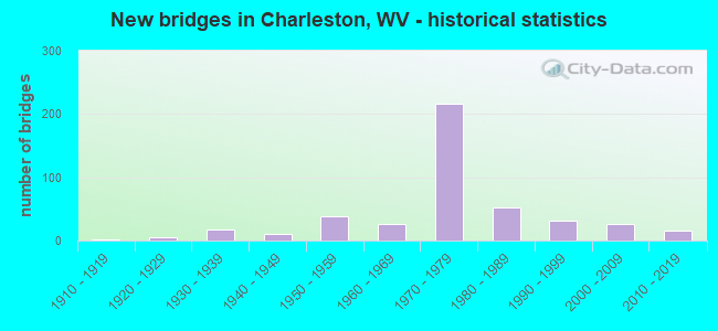
- New bridges - historical statistics
- 21910-1919
- 61920-1929
- 171930-1939
- 111940-1949
- 381950-1959
- 271960-1969
- 2161970-1979
- 531980-1989
- 311990-1999
- 272000-2009
- 162010-2019
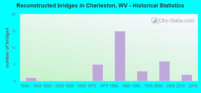
- Reconstructed bridges - Historical Statistics
- 11940-1949
- 01950-1959
- 01960-1969
- 51970-1979
- 151980-1989
- 31990-1999
- 62000-2009
- 22010-2019
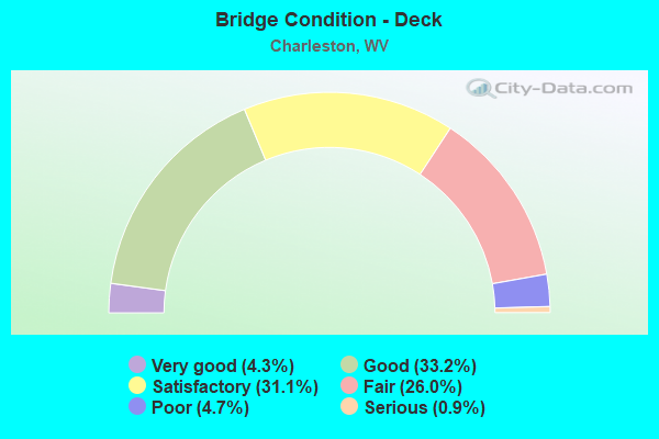
- Bridge Condition - Deck
- 4.3%Very good
- 33.2%Good
- 31.1%Satisfactory
- 26.0%Fair
- 4.7%Poor
- 0.9%Serious
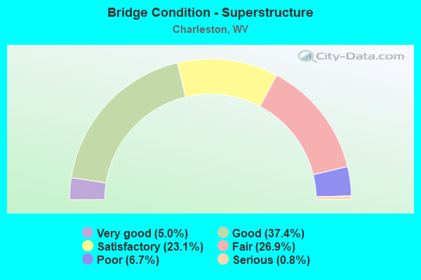
- Bridge Condition - Superstructure
- 5.0%Very good
- 37.4%Good
- 23.1%Satisfactory
- 26.9%Fair
- 6.7%Poor
- 0.8%Serious
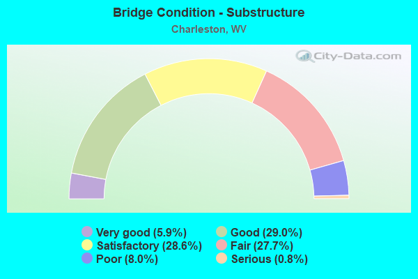
- Bridge Condition - Substructure
- 5.9%Very good
- 29.0%Good
- 28.6%Satisfactory
- 27.7%Fair
- 8.0%Poor
- 0.8%Serious
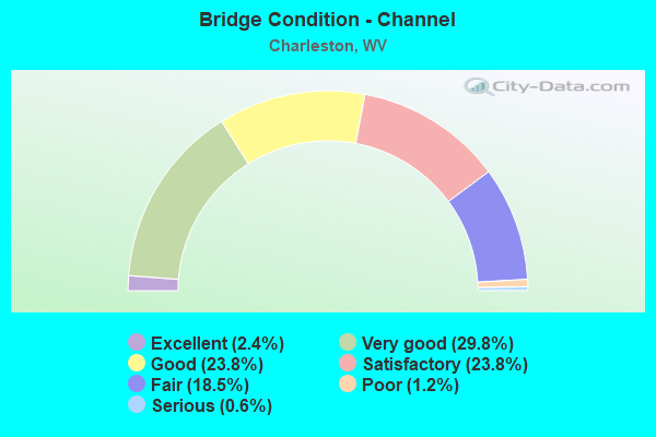
- Bridge Condition - Channel
- 2.4%Excellent
- 29.8%Very good
- 23.8%Good
- 23.8%Satisfactory
- 18.5%Fair
- 1.2%Poor
- 0.6%Serious
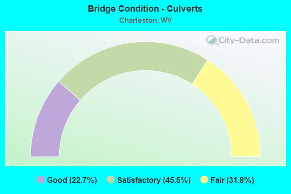
- Bridge Condition - Culverts
- 22.7%Good
- 45.5%Satisfactory
- 31.8%Fair
Find on map >> Show street view
Structure Number: 20A903, Location: 0.01 E OF I-64 (Lat: 38.354711, Lng: -81.644981), Route carried "on" structure: City street N0280, Year Built: 1938, Year Reconstructed: 1984, Status: Posted for load, Structure Length: 15.46m (50.72ft), Average Daily Traffic: 12,802 (year 2018), Truck Traffic: 8%, Average Future Daily Traffic: 15,618 (year 2038), Design Load: H 20, Features Intersected: ELK RIVER, Facility Carried by Structure: KANAWHA BOULEVARD
Minimum Vertical Clearance: 30+ m (98+ ft), Kilometerpoint: 0.048, Lanes on structure: 5, Owner: City or Municipal Highway Agency, Approaching Roadway Width: 14.9m (48.9ft), Navigation Control: Yes ( Vertical Clearance: 11.0m (36.1ft), Horizontal Clearance: 71.3m (233.9ft)), Material/Design: Steel continuous, Design/Construction: Girder and Floorbeam System, Number Of Spans In Main Unit: 1, Number Of Approach Spans: 2, Length of Maximum Span: 76.2m (250.0ft), Curb or Sidewalk Widths: Left: 2.4m (7.9ft), Right: 2.4m (7.9ft), Curb-To-Curb Width: 14.8m (48.6ft), Out-to-Out Width: 20.5m (67.3ft)
Condition: Deck: Fair, Superstructure: Fair, Substructure: Fair, Channel: Good, Operating Rating: 49.9 metric tons, Method Used To Determine Operating Rating: Load Factor (LF), Inventory Rating: 29.9 metric tons, Method Used To Determine Inventory Rating: Load Factor (LF), Structural Evaluation: Somewhat better than minimum adequacy, Deck Geometry: High priority of replacement, Waterway Adequacy: Equal to present desirable criteria, Approach Roadway Alignment: Equal to present desirable criteria, Bridge Posting: Required (Relationship of Operating Rating to Maximum Legal Load: 0.1 - 9.9% below), Length Of Structure Improvement: 15.46m (50.72ft), Designated Inspection Frequency: Every 24 months, Critical Feature Inspection Frequency: Every 24 months, Underwater Inspection Frequency: Every 60 months, Inspection Date: July 2020, Critical Feature Inspection Date: July 2020, Underwater Inspection Date: September 2020, Bridge Improvement Cost: $1,250,000, Roadway Improvement Cost: $100,000, Total Project Cost: $1,350,000 ( Estimate for 2020), Deck Structure Type: Closed Grating, Wearing Surface/Protective System: Wearing Surface: Bituminous
Find on map >> Show street view
Structure Number: 20A904, Location: 0.01 MI E OF I-64 (Lat: 38.356511, Lng: -81.643039), Route carried "on" structure: City street N0280, Year Built: 1955, Year Reconstructed: 1992, Status: Open, Structure Length: 19.05m (62.50ft), Average Daily Traffic: 7,900 (year 2018), Truck Traffic: 8%, Average Future Daily Traffic: 13,131 (year 2038), Design Load: HS 20, Features Intersected: COLUMBIA AVE & ELK RIVER, Facility Carried by Structure: QUARRIER STREET
Minimum Vertical Clearance: 30+ m (98+ ft), Kilometerpoint: 0.064, Lanes on structure: 4, Lanes under structure: 2, Owner: City or Municipal Highway Agency, Approaching Roadway Width: 13.1m (43.0ft), Skew: 1 degrees, Navigation Control: Yes ( Vertical Clearance: 10.1m (33.1ft), Horizontal Clearance: 67.4m (221.1ft)), Material/Design: Steel continuous, Design/Construction: Stringer/Multi-beam, Number Of Spans In Main Unit: 1, Number Of Approach Spans: 5, Length of Maximum Span: 70.1m (230.0ft), Curb or Sidewalk Widths: Left: 2.1m (6.9ft), Right: 2.1m (6.9ft), Curb-To-Curb Width: 13.2m (43.3ft), Out-to-Out Width: 17.5m (57.4ft)
Condition: Deck: Good, Superstructure: Satisfactory, Substructure: Poor, Channel: Good, Operating Rating: 62.6 metric tons, Method Used To Determine Operating Rating: Load Factor (LF), Inventory Rating: 37.2 metric tons, Method Used To Determine Inventory Rating: Load Factor (LF), Structural Evaluation: Meets minimum limits, Deck Geometry: High priority of replacement, Waterway Adequacy: Equal to present desirable criteria, Approach Roadway Alignment: Equal to present desirable criteria, Length Of Structure Improvement: 19.05m (62.50ft), Designated Inspection Frequency: Every 24 months, Underwater Inspection Frequency: Every 60 months, Inspection Date: May 2020, Underwater Inspection Date: September 2020, Bridge Improvement Cost: $850,000, Roadway Improvement Cost: $50,000, Total Project Cost: $900,000 ( Estimate for 2020), Deck Structure Type: Concrete Cast-file-Place, Wearing Surface/Protective System: Wearing Surface: Monolithic Concrete, Deck Protection: Epoxy Coated Reinforcing
Find on map >> Show street view
Structure Number: 20A905, Location: 0.10 MI S OF US 119 (Lat: 38.358331, Lng: -81.627469), Route carried "on" structure: City street N0280, Year Built: 1992, Status: Open, Structure Length: 13.00m (42.65ft), Average Daily Traffic: 8,900 (year 2017), Truck Traffic: 8%, Average Future Daily Traffic: 12,994 (year 2037), Design Load: HS 25 or greater, Features Intersected: ELK RIVER, Facility Carried by Structure: SPRING STREET
Minimum Vertical Clearance: 30+ m (98+ ft), Kilometerpoint: 0.080, Lanes on structure: 2, Owner: City or Municipal Highway Agency, Approaching Roadway Width: 8.5m (27.9ft), Navigation Control: Yes ( Vertical Clearance: 8.8m (28.9ft), Horizontal Clearance: 65.5m (214.9ft)), Material/Design: Steel continuous, Design/Construction: Stringer/Multi-beam, Number Of Spans In Main Unit: 1, Number Of Approach Spans: 2, Length of Maximum Span: 67.1m (220.1ft), Curb or Sidewalk Widths: Left: 0.0m, Right: 1.8m (5.9ft), Curb-To-Curb Width: 8.5m (27.9ft), Out-to-Out Width: 11.0m (36.1ft)
Condition: Deck: Satisfactory, Superstructure: Good, Substructure: Good, Channel: Very good, Operating Rating: 72.6 metric tons, Method Used To Determine Operating Rating: Load Factor (LF), Inventory Rating: 43.5 metric tons, Method Used To Determine Inventory Rating: Load Factor (LF), Structural Evaluation: Better than present minimum criteria, Deck Geometry: Meets minimum limits, Waterway Adequacy: Superior to present desirable criteria, Approach Roadway Alignment: Equal to present desirable criteria, Designated Inspection Frequency: Every 24 months, Underwater Inspection Frequency: Every 60 months, Inspection Date: Febuary 2020, Underwater Inspection Date: August 2021, Deck Structure Type: Concrete Cast-file-Place, Wearing Surface/Protective System: Wearing Surface: Monolithic Concrete, Deck Protection: Epoxy Coated Reinforcing
Find on map >> Show street view
Structure Number: 20A907, Location: 0.05 MI S OF WV 61 (Lat: 38.333119, Lng: -81.622589), Route carried "on" structure: City street N0280, Year Built: 1964, Status: Open, Structure Length: 0.99m (3.25ft), Average Daily Traffic: 700 (year 2015), Truck Traffic: 8%, Average Future Daily Traffic: 854 (year 2035), Design Load: HS 15, Features Intersected: LICK BRANCH, Facility Carried by Structure: SO RUFFNER ROAD
Minimum Vertical Clearance: 30+ m (98+ ft), Kilometerpoint: 0.113, Lanes on structure: 2, Owner: City or Municipal Highway Agency, Approaching Roadway Width: 7.9m (25.9ft), Skew: 3 degrees, Material/Design: Concrete, Design/Construction: Slab, Number Of Spans In Main Unit: 1, Length of Maximum Span: 9.4m (30.8ft), Curb or Sidewalk Widths: Left: 0.3m (1.0ft), Right: 1.5m (4.9ft), Curb-To-Curb Width: 7.9m (25.9ft), Out-to-Out Width: 8.5m (27.9ft)
Condition: Deck: Satisfactory, Superstructure: Fair, Substructure: Satisfactory, Channel: Satisfactory, Operating Rating: 53.5 metric tons, Method Used To Determine Operating Rating: Field evaluation and documented engineering judgment, Inventory Rating: 24.5 metric tons, Method Used To Determine Inventory Rating: Field evaluation and documented engineering judgment, Structural Evaluation: Somewhat better than minimum adequacy, Deck Geometry: Somewhat better than minimum adequacy, Waterway Adequacy: Better than present minimum criteria, Approach Roadway Alignment: Equal to present desirable criteria, Designated Inspection Frequency: Every 24 months, Inspection Date: January 2021, Deck Structure Type: Concrete Cast-file-Place, Wearing Surface/Protective System: Wearing Surface: Monolithic Concrete
Find on map >> Show street view
Structure Number: 20A909, Location: 1.40 MI S OF WV 61 F (Lat: 38.334231, Lng: -81.644150), Route carried "on" structure: City street N0280, Year Built: 1924, Status: Open, Structure Length: 5.52m (18.11ft), Average Daily Traffic: 2,500 (year 2015), Truck Traffic: 8%, Average Future Daily Traffic: 3,050 (year 2035), Features Intersected: FORK OF PORTERS HOLLOW, Facility Carried by Structure: LOUDEN HEIGHTS RD.
Minimum Vertical Clearance: 30+ m (98+ ft), Kilometerpoint: 0.145, Lanes on structure: 2, Owner: City or Municipal Highway Agency, Approaching Roadway Width: 6.1m (20.0ft), Material/Design: Concrete continuous, Design/Construction: Arch - Deck, Number Of Spans In Main Unit: 2, Length of Maximum Span: 26.5m (86.9ft), Curb or Sidewalk Widths: Left: 0.1m (0.3ft), Right: 0.6m (2.0ft), Curb-To-Curb Width: 6.1m (20.0ft), Out-to-Out Width: 7.3m (24.0ft)
Condition: Deck: Poor, Superstructure: Fair, Substructure: Fair, Channel: Very good, Operating Rating: 41.7 metric tons, Method Used To Determine Operating Rating: Field evaluation and documented engineering judgment, Inventory Rating: 16.3 metric tons, Method Used To Determine Inventory Rating: Field evaluation and documented engineering judgment, Structural Evaluation: Meets minimum limits, Deck Geometry: High priority of replacement, Waterway Adequacy: Superior to present desirable criteria, Approach Roadway Alignment: Somewhat better than minimum adequacy, Length Of Structure Improvement: 5.52m (18.11ft), Designated Inspection Frequency: Every 24 months, Inspection Date: January 2021, Bridge Improvement Cost: $1,250,000, Roadway Improvement Cost: $250,000, Total Project Cost: $1,500,000 ( Estimate for 2021), Deck Structure Type: Concrete Cast-file-Place, Wearing Surface/Protective System: Wearing Surface: Bituminous
Find on map >> Show street view
Structure Number: 20A912, Location: 0.63 MIL N. OF WV 114 (Lat: 38.349281, Lng: -81.618489), Route carried "on" structure: ServiceCity street N0280, Year Built: 1975, Status: Open, Structure Length: 13.91m (45.64ft), Average Daily Traffic: 5,500 (year 2015), Truck Traffic: 8%, Average Future Daily Traffic: 7,920 (year 2035), Design Load: HS 20, Features Intersected: I-77, PIEDMONT, RICHARDS, Facility Carried by Structure: FARNSWORTH DRIVE
Minimum Vertical Clearance: 30+ m (98+ ft), Kilometerpoint: 0.193, Lanes on structure: 2, Lanes under structure: 2, Owner: City or Municipal Highway Agency, Approaching Roadway Width: 7.9m (25.9ft), Skew: 9 degrees, Material/Design: Steel, Design/Construction: Stringer/Multi-beam, Number Of Spans In Main Unit: 1, Number Of Approach Spans: 4, Length of Maximum Span: 45.4m (149.0ft), Curb or Sidewalk Widths: Left: 1.5m (4.9ft), Right: 0.0m, Curb-To-Curb Width: 7.9m (25.9ft), Out-to-Out Width: 10.6m (34.8ft)
Condition: Deck: Satisfactory, Superstructure: Fair, Substructure: Fair, Operating Rating: 69.8 metric tons, Method Used To Determine Operating Rating: Load Factor (LF), Inventory Rating: 41.7 metric tons, Method Used To Determine Inventory Rating: Load Factor (LF), Structural Evaluation: Somewhat better than minimum adequacy, Deck Geometry: High priority of corrective action, Underclear: Somewhat better than minimum adequacy, Approach Roadway Alignment: Equal to present minimum criteria, Length Of Structure Improvement: 13.91m (45.64ft), Designated Inspection Frequency: Every 24 months, Inspection Date: March 2021, Bridge Improvement Cost: $450,000, Roadway Improvement Cost: $50,000, Total Project Cost: $650,000 ( Estimate for 2021), Deck Structure Type: Concrete Cast-file-Place, Wearing Surface/Protective System: Wearing Surface: Integral Concrete
Find on map >> Show street view
Structure Number: 20A917, Location: 0.03 MI W OF CR 21 (Lat: 38.379369, Lng: -81.661819), Route carried "on" structure: City street N0280, Year Built: 1955, Status: Posted for load, Structure Length: 3.75m (12.30ft), Average Daily Traffic: 1,867 (year 2018), Truck Traffic: 3%, Average Future Daily Traffic: 2,278 (year 2038), Design Load: HS 20, Features Intersected: TWOMILE CREEK, Facility Carried by Structure: SCHOOL STREET
Minimum Vertical Clearance: 30+ m (98+ ft), Kilometerpoint: 0.274, Lanes on structure: 2, Owner: City or Municipal Highway Agency, Approaching Roadway Width: 6.4m (21.0ft), Skew: 1 degrees, Material/Design: Concrete, Design/Construction: Slab, Number Of Spans In Main Unit: 1, Number Of Approach Spans: 3, Length of Maximum Span: 8.8m (28.9ft), Curb or Sidewalk Widths: Left: 0.2m (0.7ft), Right: 1.4m (4.6ft), Curb-To-Curb Width: 6.0m (19.7ft), Out-to-Out Width: 6.5m (21.3ft)
Condition: Deck: Satisfactory, Superstructure: Fair, Substructure: Fair, Channel: Satisfactory, Operating Rating: 53.5 metric tons, Method Used To Determine Operating Rating: Field evaluation and documented engineering judgment, Inventory Rating: 24.5 metric tons, Method Used To Determine Inventory Rating: Field evaluation and documented engineering judgment, Structural Evaluation: Somewhat better than minimum adequacy, Deck Geometry: High priority of replacement, Waterway Adequacy: Superior to present desirable criteria, Approach Roadway Alignment: Equal to present minimum criteria, Length Of Structure Improvement: 3.75m (12.30ft), Designated Inspection Frequency: Every 24 months, Inspection Date: January 2021, Bridge Improvement Cost: $450,000, Roadway Improvement Cost: $50,000, Total Project Cost: $500,000 ( Estimate for 2021), Deck Structure Type: Concrete Cast-file-Place, Wearing Surface/Protective System: Wearing Surface: Latex Concrete
Find on map >> Show street view
Structure Number: 20A921, Location: 0.10 MI S OF US 60 (Lat: 38.388539, Lng: -81.833989), Route carried "on" structure: City street N1420, Year Built: 1929, Status: Open, Structure Length: 0.85m (2.79ft), Average Daily Traffic: 600 (year 2021), Truck Traffic: 3%, Average Future Daily Traffic: 732 (year 2041), Features Intersected: CR 6/6, Facility Carried by Structure: THIRD AVENUE
Minimum Vertical Clearance: 30+ m (98+ ft), Kilometerpoint: 0.032, Lanes on structure: 2, Lanes under structure: 2, Owner: City or Municipal Highway Agency, Approaching Roadway Width: 6.4m (21.0ft), Material/Design: Concrete, Design/Construction: Tee Beam, Number Of Spans In Main Unit: 1, Length of Maximum Span: 8.0m (26.2ft), Curb or Sidewalk Widths: Left: 1.5m (4.9ft), Right: 0.0m, Curb-To-Curb Width: 6.2m (20.3ft), Out-to-Out Width: 8.2m (26.9ft)
Condition: Deck: Fair, Superstructure: Fair, Substructure: Fair, Operating Rating: 47.2 metric tons, Method Used To Determine Operating Rating: Field evaluation and documented engineering judgment, Inventory Rating: 21.8 metric tons, Method Used To Determine Inventory Rating: Field evaluation and documented engineering judgment, Structural Evaluation: Somewhat better than minimum adequacy, Deck Geometry: High priority of corrective action, Underclear: High priority of corrective action, Approach Roadway Alignment: Equal to present desirable criteria, Length Of Structure Improvement: 0.85m (2.79ft), Designated Inspection Frequency: Every 24 months, Inspection Date: January 2021, Bridge Improvement Cost: $200,000, Roadway Improvement Cost: $50,000, Total Project Cost: $250,000 ( Estimate for 2021), Deck Structure Type: Concrete Cast-file-Place, Wearing Surface/Protective System: Wearing Surface: Bituminous
Find on map >> Show street view
Structure Number: 20A922, Location: 0.12 MI S OF US 60 (Lat: 38.388111, Lng: -81.834161), Route carried "on" structure: City street N1420, Year Built: 1929, Status: Open, Structure Length: 0.85m (2.79ft), Average Daily Traffic: 600 (year 2021), Truck Traffic: 3%, Average Future Daily Traffic: 732 (year 2041), Features Intersected: CR 6/6, Facility Carried by Structure: FOURTH AVENUE
Minimum Vertical Clearance: 30+ m (98+ ft), Kilometerpoint: 0.048, Lanes on structure: 2, Lanes under structure: 2, Owner: City or Municipal Highway Agency, Approaching Roadway Width: 8.2m (26.9ft), Material/Design: Concrete, Design/Construction: Tee Beam, Number Of Spans In Main Unit: 1, Length of Maximum Span: 8.0m (26.2ft), Curb or Sidewalk Widths: Left: 0.2m (0.7ft), Right: 1.4m (4.6ft), Curb-To-Curb Width: 6.2m (20.3ft), Out-to-Out Width: 8.3m (27.2ft)
Condition: Deck: Fair, Superstructure: Fair, Substructure: Fair, Operating Rating: 47.2 metric tons, Method Used To Determine Operating Rating: Field evaluation and documented engineering judgment, Inventory Rating: 21.8 metric tons, Method Used To Determine Inventory Rating: Field evaluation and documented engineering judgment, Structural Evaluation: Somewhat better than minimum adequacy, Deck Geometry: High priority of corrective action, Underclear: High priority of corrective action, Approach Roadway Alignment: Better than present minimum criteria, Length Of Structure Improvement: 0.85m (2.79ft), Designated Inspection Frequency: Every 24 months, Inspection Date: January 2021, Bridge Improvement Cost: $200,000, Roadway Improvement Cost: $50,000, Total Project Cost: $250,000 ( Estimate for 2021), Deck Structure Type: Concrete Cast-file-Place, Wearing Surface/Protective System: Wearing Surface: Monolithic Concrete
Find on map >> Show street view
Structure Number: 20A925, Location: 0.01 MI S OF CR 46 (Lat: 38.366200, Lng: -81.580569), Route carried "on" structure: City street N0280, Year Built: 1986, Status: Open, Structure Length: 1.03m (3.38ft), Average Daily Traffic: 100 (year 2015), Average Future Daily Traffic: 144 (year 2035), Design Load: H 20, Features Intersected: ELK TWOMILE CREEK, Facility Carried by Structure: HUBBARD RD
Minimum Vertical Clearance: 30+ m (98+ ft), Kilometerpoint: 0.290, Lanes on structure: 1, Owner: City or Municipal Highway Agency, Approaching Roadway Width: 4.0m (13.1ft), Material/Design: Steel, Design/Construction: Stringer/Multi-beam, Number Of Spans In Main Unit: 1, Length of Maximum Span: 9.4m (30.8ft), Curb or Sidewalk Widths: Left: 0.1m (0.3ft), Right: 0.1m (0.3ft), Curb-To-Curb Width: 4.2m (13.8ft), Out-to-Out Width: 4.6m (15.1ft)
Condition: Deck: Satisfactory, Superstructure: Satisfactory, Substructure: Good, Channel: Fair, Operating Rating: 65.3 metric tons, Method Used To Determine Operating Rating: Load Factor (LF), Inventory Rating: 39.0 metric tons, Method Used To Determine Inventory Rating: Load Factor (LF), Structural Evaluation: Equal to present minimum criteria, Deck Geometry: Somewhat better than minimum adequacy, Waterway Adequacy: Somewhat better than minimum adequacy, Approach Roadway Alignment: High priority of corrective action, Length Of Structure Improvement: 1.03m (3.38ft), Designated Inspection Frequency: Every 24 months, Inspection Date: Febuary 2021, Bridge Improvement Cost: $150,000, Roadway Improvement Cost: $50,000, Total Project Cost: $200,000 ( Estimate for 2021), Deck Structure Type: Closed Grating, Wearing Surface/Protective System: Wearing Surface: Bituminous, Deck Protection: Epoxy Coated Reinforcing
Find on map >> Show street view
Structure Number: 20A927, Location: 0.40 MIL S OF WV 61 (Lat: 38.346561, Lng: -81.638831), Route carried "on" structure: City street N0280, Year Built: 1999, Status: Open, Structure Length: 10.91m (35.79ft), Average Daily Traffic: 13,534 (year 2021), Truck Traffic: 4%, Average Future Daily Traffic: 14,104 (year 2039), Design Load: HS 25 or greater, Features Intersected: AMTRAK STATION PLATFORM, Facility Carried by Structure: CITY STREET N02/80
Minimum Vertical Clearance: 30+ m (98+ ft), Kilometerpoint: 0.097, Lanes on structure: 2, Owner: City or Municipal Highway Agency, Approaching Roadway Width: 6.1m (20.0ft), Material/Design: Prestressed concrete, Design/Construction: Box Beam or Girders - Multiple, Number Of Spans In Main Unit: 5, Number Of Approach Spans: 3, Length of Maximum Span: 14.8m (48.6ft), Curb or Sidewalk Widths: Left: 1.6m (5.2ft), Right: 0.1m (0.3ft), Curb-To-Curb Width: 6.1m (20.0ft), Out-to-Out Width: 8.7m (28.5ft)
Condition: Deck: Satisfactory, Superstructure: Satisfactory, Substructure: Fair, Operating Rating: 56.2 metric tons, Method Used To Determine Operating Rating: Load Factor (LF), Inventory Rating: 33.6 metric tons, Method Used To Determine Inventory Rating: Load Factor (LF), Structural Evaluation: Somewhat better than minimum adequacy, Deck Geometry: High priority of replacement, Approach Roadway Alignment: Equal to present desirable criteria, Designated Inspection Frequency: Every 24 months, Inspection Date: March 2021, Deck Structure Type: Concrete Cast-file-Place, Wearing Surface/Protective System: Wearing Surface: Latex Concrete, Deck Protection: Epoxy Coated Reinforcing
Find on map >> Show street view
Structure Number: 20A929, Location: 0.01 MI W OF WV 21 (Lat: 38.392361, Lng: -81.659231), Route carried "on" structure: City street N0280, Year Built: 2009, Status: Open, Structure Length: 2.38m (7.81ft), Average Daily Traffic: 350 (year 2018), Average Future Daily Traffic: 550 (year 2038), Design Load: HS 25 or greater, Features Intersected: TWOMILE CREEK, Facility Carried by Structure: SCRAGGS DRIVE
Minimum Vertical Clearance: 30+ m (98+ ft), Kilometerpoint: 0.322, Lanes on structure: 2, Owner: City or Municipal Highway Agency, Approaching Roadway Width: 6.7m (22.0ft), Material/Design: Prestressed concrete, Design/Construction: Box Beam or Girders - Multiple, Number Of Spans In Main Unit: 1, Length of Maximum Span: 23.5m (77.1ft), Curb or Sidewalk Widths: Left: 1.5m (4.9ft), Right: 0.0m, Curb-To-Curb Width: 6.7m (22.0ft), Out-to-Out Width: 8.5m (27.9ft)
Condition: Deck: Fair, Superstructure: Fair, Substructure: Good, Channel: Good, Operating Rating: 86.2 metric tons, Method Used To Determine Operating Rating: Load Factor (LF), Inventory Rating: 51.7 metric tons, Method Used To Determine Inventory Rating: Load Factor (LF), Structural Evaluation: Somewhat better than minimum adequacy, Deck Geometry: Meets minimum limits, Waterway Adequacy: Equal to present desirable criteria, Approach Roadway Alignment: Equal to present desirable criteria, Designated Inspection Frequency: Every 24 months, Inspection Date: Febuary 2021, Deck Structure Type: Concrete Precast Panels, Wearing Surface/Protective System: Wearing Surface: Bituminous, Membrane: Built-up, Deck Protection: Epoxy Coated Reinforcing
Find on map >> Show street view
Structure Number: 40A028, Location: 0.74 MI E OF CR 33/6 (Lat: 38.154300, Lng: -81.304300), Route carried "on" structure: County highway 33, Year Built: 1961, Status: Posted for load, Structure Length: 4.59m (15.06ft), Average Daily Traffic: 3,100 (year 2020), Truck Traffic: 4%, Average Future Daily Traffic: 4,154 (year 2040), Design Load: HS 15, Features Intersected: CSX RAILROAD
Minimum Vertical Clearance: 30+ m (98+ ft), Kilometerpoint: 9.527, Lanes on structure: 2, Owner: State Highway Agency, Approaching Roadway Width: 6.7m (22.0ft), Skew: 2 degrees, Material/Design: Steel continuous, Design/Construction: Stringer/Multi-beam, Number Of Spans In Main Unit: 1, Number Of Approach Spans: 2, Length of Maximum Span: 18.6m (61.0ft), Curb or Sidewalk Widths: Left: 0.8m (2.6ft), Right: 0.8m (2.6ft), Curb-To-Curb Width: 8.5m (27.9ft), Out-to-Out Width: 10.7m (35.1ft)
Condition: Deck: Poor, Superstructure: Poor, Substructure: Poor, Operating Rating: 34.5 metric tons, Method Used To Determine Operating Rating: Load Factor (LF), Inventory Rating: 20.9 metric tons, Method Used To Determine Inventory Rating: Load Factor (LF), Structural Evaluation: Meets minimum limits, Deck Geometry: Meets minimum limits, Underclear: Meets minimum limits, Approach Roadway Alignment: Equal to present desirable criteria, Bridge Posting: Required (Relationship of Operating Rating to Maximum Legal Load: 20.0 - 29.9% below), Length Of Structure Improvement: 4.59m (15.06ft), Designated Inspection Frequency: Every 24 months, Inspection Date: October 2021, Bridge Improvement Cost: $1,350,000, Roadway Improvement Cost: $100,000, Total Project Cost: $1,450,000 ( Estimate for 2019), Deck Structure Type: Concrete Cast-file-Place, Wearing Surface/Protective System: Wearing Surface: Bituminous
Find on map >> Show street view
Structure Number: 40A044, Location: 0.01 MI E OF CR 31 (Lat: 38.448589, Lng: -81.777111), Route carried "on" structure: County highway 38, Year Built: 1988, Status: Open, Structure Length: 7.50m (24.61ft), Average Daily Traffic: 1,700 (year 2018), Truck Traffic: 3%, Average Future Daily Traffic: 2,295 (year 2038), Design Load: HS 20, Features Intersected: POCATALICO RIVER
Minimum Vertical Clearance: 30+ m (98+ ft), Kilometerpoint: 0.016, Lanes on structure: 2, Owner: State Highway Agency, Approaching Roadway Width: 6.1m (20.0ft), Skew: 3 degrees, Material/Design: Steel continuous, Design/Construction: Girder and Floorbeam System, Number Of Spans In Main Unit: 1, Number Of Approach Spans: 2, Length of Maximum Span: 28.7m (94.2ft), Curb-To-Curb Width: 7.6m (24.9ft), Out-to-Out Width: 8.6m (28.2ft)
Condition: Deck: Good, Superstructure: Good, Substructure: Good, Channel: Satisfactory, Operating Rating: 79.8 metric tons, Method Used To Determine Operating Rating: Load Factor (LF), Inventory Rating: 48.1 metric tons, Method Used To Determine Inventory Rating: Load Factor (LF), Structural Evaluation: Better than present minimum criteria, Deck Geometry: Meets minimum limits, Waterway Adequacy: Superior to present desirable criteria, Approach Roadway Alignment: Somewhat better than minimum adequacy, Designated Inspection Frequency: Every 24 months, Underwater Inspection Frequency: Every 60 months, Inspection Date: October 2020, Underwater Inspection Date: September 2018, Deck Structure Type: Concrete Cast-file-Place, Wearing Surface/Protective System: Wearing Surface: Monolithic Concrete, Deck Protection: Epoxy Coated Reinforcing
Find on map >> Show street view
Structure Number: 40A057, Location: 0.59 MI E OF CR 60/27 (Lat: 38.415819, Lng: -82.020081), Route carried "on" structure: US 60, Year Built: 1943, Year Reconstructed: 1988, Status: Open, Structure Length: 1.71m (5.61ft), Average Daily Traffic: 5,500 (year 2018), Truck Traffic: 27%, Average Future Daily Traffic: 7,425 (year 2038), Design Load: HS 20, Features Intersected: HURRICANE CREEK
Minimum Vertical Clearance: 30+ m (98+ ft), Kilometerpoint: 2.945, Lanes on structure: 2, Owner: State Highway Agency, Approaching Roadway Width: 7.9m (25.9ft), Material/Design: Steel, Design/Construction: Stringer/Multi-beam, Number Of Spans In Main Unit: 1, Length of Maximum Span: 15.6m (51.2ft), Curb-To-Curb Width: 12.2m (40.0ft), Out-to-Out Width: 13.3m (43.6ft)
Condition: Deck: Satisfactory, Superstructure: Satisfactory, Substructure: Satisfactory, Channel: Satisfactory, Operating Rating: 88.9 metric tons, Method Used To Determine Operating Rating: Load Factor (LF), Inventory Rating: 58.0 metric tons, Method Used To Determine Inventory Rating: Load Factor (LF), Structural Evaluation: Equal to present minimum criteria, Deck Geometry: Somewhat better than minimum adequacy, Waterway Adequacy: Equal to present minimum criteria, Approach Roadway Alignment: Equal to present desirable criteria, Length Of Structure Improvement: 1.71m (5.61ft), Designated Inspection Frequency: Every 24 months, Inspection Date: January 2020, Bridge Improvement Cost: $200,000, Roadway Improvement Cost: $50,000, Total Project Cost: $250,000 ( Estimate for 2020), Deck Structure Type: Concrete Cast-file-Place, Wearing Surface/Protective System: Wearing Surface: Integral Concrete, Deck Protection: Epoxy Coated Reinforcing
Find on map >> Show street view
Structure Number: 40A058, Location: 0.41 MI N OF CR 31 (Lat: 38.478331, Lng: -81.813550), Route carried "on" structure: State highway 62, Year Built: 1988, Status: Open, Structure Length: 6.26m (20.54ft), Average Daily Traffic: 8,615 (year 2016), Truck Traffic: 8%, Average Future Daily Traffic: 11,630 (year 2036), Design Load: HS 20+Mod, Features Intersected: POCATALICO RIVER
Minimum Vertical Clearance: 30+ m (98+ ft), Kilometerpoint: 4.925, Lanes on structure: 2, Owner: State Highway Agency, Approaching Roadway Width: 14.6m (47.9ft), Material/Design: Steel continuous, Design/Construction: Stringer/Multi-beam, Number Of Spans In Main Unit: 2, Length of Maximum Span: 30.5m (100.1ft), Curb or Sidewalk Widths: Left: 1.3m (4.3ft), Right: 0.0m, Curb-To-Curb Width: 12.0m (39.4ft), Out-to-Out Width: 12.9m (42.3ft)
Condition: Deck: Satisfactory, Superstructure: Good, Substructure: Good, Channel: Very good, Operating Rating: 88.9 metric tons, Method Used To Determine Operating Rating: Load Factor (LF), Inventory Rating: 71.7 metric tons, Method Used To Determine Inventory Rating: Load Factor (LF), Structural Evaluation: Better than present minimum criteria, Deck Geometry: Somewhat better than minimum adequacy, Waterway Adequacy: Equal to present desirable criteria, Approach Roadway Alignment: Equal to present desirable criteria, Designated Inspection Frequency: Every 48 months, Underwater Inspection Frequency: Every 60 months, Inspection Date: May 2018, Underwater Inspection Date: September 2018, Deck Structure Type: Concrete Cast-file-Place, Wearing Surface/Protective System: Wearing Surface: Monolithic Concrete, Deck Protection: Epoxy Coated Reinforcing
Find on map >> Show street view
Structure Number: 40A066, Location: 0.76 MI. E. OF CR 19 SLS (Lat: 38.445261, Lng: -82.006531), Route carried "on" structure: Interstate 64, Year Built: 1959, Year Reconstructed: 1988, Status: Open, Structure Length: 4.17m (13.68ft), Average Daily Traffic: 17,700 (year 2018), Truck Traffic: 17%, Average Future Daily Traffic: 23,895 (year 2038), Design Load: HS 20+Mod, Features Intersected: HURRICANE CREEK
Minimum Vertical Clearance: 30+ m (98+ ft), Kilometerpoint: 55.699, Lanes on structure: 2, Base Highway Network: Yes, Owner: State Highway Agency, Approaching Roadway Width: 11.6m (38.1ft), Material/Design: Steel continuous, Design/Construction: Stringer/Multi-beam, Number Of Spans In Main Unit: 1, Number Of Approach Spans: 2, Length of Maximum Span: 15.9m (52.2ft), Curb-To-Curb Width: 11.7m (38.4ft), Out-to-Out Width: 12.8m (42.0ft)
Condition: Deck: Satisfactory, Superstructure: Good, Substructure: Satisfactory, Channel: Good, Operating Rating: 88.9 metric tons, Method Used To Determine Operating Rating: Load Factor (LF), Inventory Rating: 59.0 metric tons, Method Used To Determine Inventory Rating: Load Factor (LF), Structural Evaluation: Equal to present minimum criteria, Deck Geometry: Equal to present minimum criteria, Waterway Adequacy: Equal to present desirable criteria, Approach Roadway Alignment: Equal to present desirable criteria, Length Of Structure Improvement: 6.28m (20.60ft), Designated Inspection Frequency: Every 24 months, Inspection Date: March 2020, Bridge Improvement Cost: $400,000, Roadway Improvement Cost: $100,000, Total Project Cost: $500,000 ( Estimate for 2020), Deck Structure Type: Concrete Cast-file-Place, Wearing Surface/Protective System: Wearing Surface: Monolithic Concrete, Deck Protection: Epoxy Coated Reinforcing
Find on map >> Show street view
Structure Number: 40A068, Location: 0.76 MI E OF CR 19 (Lat: 38.445411, Lng: -82.006650), Route carried "on" structure: Interstate 64, Year Built: 1959, Year Reconstructed: 1988, Status: Open, Structure Length: 4.17m (13.68ft), Average Daily Traffic: 17,700 (year 2018), Truck Traffic: 17%, Average Future Daily Traffic: 23,895 (year 2038), Design Load: HS 20+Mod, Features Intersected: HURRICANE CREEK
Minimum Vertical Clearance: 30+ m (98+ ft), Kilometerpoint: 55.699, Lanes on structure: 2, Base Highway Network: Yes, Owner: State Highway Agency, Approaching Roadway Width: 11.3m (37.1ft), Material/Design: Steel continuous, Design/Construction: Stringer/Multi-beam, Number Of Spans In Main Unit: 1, Number Of Approach Spans: 2, Length of Maximum Span: 15.9m (52.2ft), Curb-To-Curb Width: 11.7m (38.4ft), Out-to-Out Width: 12.8m (42.0ft)
Condition: Deck: Good, Superstructure: Good, Substructure: Satisfactory, Channel: Good, Operating Rating: 88.9 metric tons, Method Used To Determine Operating Rating: Load Factor (LF), Inventory Rating: 58.0 metric tons, Method Used To Determine Inventory Rating: Load Factor (LF), Structural Evaluation: Equal to present minimum criteria, Deck Geometry: Equal to present minimum criteria, Waterway Adequacy: Equal to present desirable criteria, Approach Roadway Alignment: Equal to present desirable criteria, Length Of Structure Improvement: 4.17m (13.68ft), Designated Inspection Frequency: Every 24 months, Inspection Date: March 2020, Bridge Improvement Cost: $800,000, Roadway Improvement Cost: $100,000, Total Project Cost: $900,000 ( Estimate for 2020), Deck Structure Type: Concrete Cast-file-Place, Wearing Surface/Protective System: Wearing Surface: Latex Concrete, Deck Protection: Epoxy Coated Reinforcing
Find on map >> Show street view
Structure Number: 40A072, Location: 2.83 MI EAST OF WV 34 F (Lat: 38.456011, Lng: -81.883400), Route carried "on" structure: Interstate 64, Year Built: 1959, Year Reconstructed: 1988, Status: Open, Structure Length: 8.85m (29.04ft), Average Daily Traffic: 32,200 (year 2020), Truck Traffic: 17%, Average Future Daily Traffic: 43,470 (year 2038), Design Load: HS 20+Mod, Features Intersected: CR 29 & ROCKY STEP RUN
Minimum Vertical Clearance: 30+ m (98+ ft), Kilometerpoint: 66.804, Lanes on structure: 2, Lanes under structure: 2, Base Highway Network: Yes, Owner: State Highway Agency, Approaching Roadway Width: 12.8m (42.0ft), Material/Design: Steel continuous, Design/Construction: Stringer/Multi-beam, Number Of Spans In Main Unit: 2, Number Of Approach Spans: 3, Length of Maximum Span: 21.0m (68.9ft), Curb-To-Curb Width: 12.0m (39.4ft), Out-to-Out Width: 13.0m (42.7ft)
Condition: Deck: Fair, Superstructure: Satisfactory, Substructure: Poor, Channel: Very good, Operating Rating: 70.7 metric tons, Method Used To Determine Operating Rating: Load Factor (LF), Inventory Rating: 42.6 metric tons, Method Used To Determine Inventory Rating: Load Factor (LF), Structural Evaluation: Meets minimum limits, Deck Geometry: Equal to present minimum criteria, Underclear: Somewhat better than minimum adequacy, Waterway Adequacy: Superior to present desirable criteria, Approach Roadway Alignment: Equal to present desirable criteria, Length Of Structure Improvement: 8.85m (29.04ft), Designated Inspection Frequency: Every 24 months, Inspection Date: Febuary 2020, Bridge Improvement Cost: $4,500,000, Roadway Improvement Cost: $500,000, Total Project Cost: $5,000,000 ( Estimate for 2020), Deck Structure Type: Concrete Cast-file-Place, Wearing Surface/Protective System: Wearing Surface: Monolithic Concrete, Deck Protection: Epoxy Coated Reinforcing
Find on map >> Show street view
Structure Number: 40A073, Location: 4.82 MI E OF WV 34 (Lat: 38.448119, Lng: -81.849139), Route carried "on" structure: Ramp Interstate 64, Year Built: 1962, Year Reconstructed: 1985, Status: Open, Structure Length: 5.74m (18.83ft), Average Daily Traffic: 6,082 (year 2020), Truck Traffic: 15%, Average Future Daily Traffic: 8,697 (year 2040), Design Load: HS 20+Mod, Features Intersected: I-64 EB & WB
Minimum Vertical Clearance: 30+ m (98+ ft), Kilometerpoint: 70.006, Lanes on structure: 2, Lanes under structure: 4, Owner: State Highway Agency, Approaching Roadway Width: 13.1m (43.0ft), Material/Design: Steel, Design/Construction: Girder and Floorbeam System, Number Of Spans In Main Unit: 1, Number Of Approach Spans: 2, Length of Maximum Span: 29.9m (98.1ft), Curb or Sidewalk Widths: Left: 0.2m (0.7ft), Right: 0.2m (0.7ft), Curb-To-Curb Width: 11.4m (37.4ft), Out-to-Out Width: 12.5m (41.0ft)
Condition: Deck: Satisfactory, Superstructure: Satisfactory, Substructure: Good, Operating Rating: 49.9 metric tons, Method Used To Determine Operating Rating: Load Factor (LF), Inventory Rating: 29.9 metric tons, Method Used To Determine Inventory Rating: Load Factor (LF), Structural Evaluation: Equal to present minimum criteria, Deck Geometry: Superior to present desirable criteria, Underclear: Meets minimum limits, Approach Roadway Alignment: Equal to present minimum criteria, Length Of Structure Improvement: 6.10m (20.01ft), Designated Inspection Frequency: Every 24 months, Critical Feature Inspection Frequency: Every 24 months, Inspection Date: October 2021, Critical Feature Inspection Date: October 2021, Bridge Improvement Cost: $1,500,000, Roadway Improvement Cost: $250,000, Total Project Cost: $1,750,000 ( Estimate for 2019), Deck Structure Type: Concrete Cast-file-Place, Wearing Surface/Protective System: Wearing Surface: Monolithic Concrete, Deck Protection: Epoxy Coated Reinforcing
Find on map >> Show street view
Structure Number: 40A074, Location: 3.18 MI E OF WV 34 (Lat: 38.455461, Lng: -81.877119), Route carried "on" structure: Interstate 64, Year Built: 1959, Year Reconstructed: 1988, Status: Open, Structure Length: 4.03m (13.22ft), Average Daily Traffic: 32,200 (year 2018), Truck Traffic: 17%, Average Future Daily Traffic: 43,470 (year 2038), Design Load: HS 20, Features Intersected: CR 33/5
Minimum Vertical Clearance: 30+ m (98+ ft), Kilometerpoint: 67.367, Lanes on structure: 2, Lanes under structure: 2, Base Highway Network: Yes, Owner: State Highway Agency, Approaching Roadway Width: 11.3m (37.1ft), Skew: 1 degrees, Material/Design: Steel continuous, Design/Construction: Stringer/Multi-beam, Number Of Spans In Main Unit: 1, Number Of Approach Spans: 2, Length of Maximum Span: 15.2m (49.9ft), Curb-To-Curb Width: 11.7m (38.4ft), Out-to-Out Width: 12.8m (42.0ft)
Condition: Deck: Fair, Superstructure: Good, Substructure: Fair, Operating Rating: 88.9 metric tons, Method Used To Determine Operating Rating: Load Factor (LF), Inventory Rating: 64.4 metric tons, Method Used To Determine Inventory Rating: Load Factor (LF), Structural Evaluation: Somewhat better than minimum adequacy, Deck Geometry: Equal to present minimum criteria, Underclear: Better than present minimum criteria, Approach Roadway Alignment: Equal to present desirable criteria, Length Of Structure Improvement: 4.03m (13.22ft), Designated Inspection Frequency: Every 24 months, Inspection Date: December 2019, Bridge Improvement Cost: $800,000, Roadway Improvement Cost: $200,000, Total Project Cost: $1,000,000 ( Estimate for 2019), Deck Structure Type: Concrete Cast-file-Place, Wearing Surface/Protective System: Wearing Surface: Monolithic Concrete, Deck Protection: Epoxy Coated Reinforcing
Find on map >> Show street view
Structure Number: 40A09, Location: 0.43 MI N OF CR 34/14 (Lat: 38.455989, Lng: -81.935539), Route carried "on" structure: State highway 34, Year Built: 1991, Status: Open, Structure Length: 6.05m (19.85ft), Average Daily Traffic: 27,300 (year 2020), Truck Traffic: 6%, Average Future Daily Traffic: 33,579 (year 2040), Design Load: HS 25 or greater, Features Intersected: I-64 EB & WB
Minimum Vertical Clearance: 5.33m (17.49ft), Kilometerpoint: 24.140, Lanes on structure: 6, Lanes under structure: 5, Owner: State Highway Agency, Approaching Roadway Width: 25.0m (82.0ft), Skew: 2 degrees, Material/Design: Steel continuous, Design/Construction: Stringer/Multi-beam, Number Of Spans In Main Unit: 2, Length of Maximum Span: 29.3m (96.1ft), Curb-To-Curb Width: 25.1m (82.3ft), Out-to-Out Width: 26.1m (85.6ft)
Condition: Deck: Good, Superstructure: Good, Substructure: Good, Operating Rating: 88.9 metric tons, Method Used To Determine Operating Rating: Load Factor (LF), Inventory Rating: 54.4 metric tons, Method Used To Determine Inventory Rating: Load Factor (LF), Structural Evaluation: Better than present minimum criteria, Deck Geometry: Meets minimum limits, Underclear: Meets minimum limits, Approach Roadway Alignment: Equal to present desirable criteria, Length Of Structure Improvement: 6.05m (19.85ft), Designated Inspection Frequency: Every 24 months, Inspection Date: September 2021, Bridge Improvement Cost: $700,000, Roadway Improvement Cost: $50,000, Total Project Cost: $750,000 ( Estimate for 2019), Deck Structure Type: Concrete Cast-file-Place, Wearing Surface/Protective System: Wearing Surface: Monolithic Concrete, Deck Protection: Epoxy Coated Reinforcing
Find on map >> Show street view
Structure Number: 40A109, Location: 0.07 MI W OF WV 62 (Lat: 38.454961, Lng: -81.815850), Route carried "on" structure: County highway 3515, Year Built: 1972, Status: Open, Structure Length: 0.72m (2.36ft), Average Daily Traffic: 750 (year 2018), Truck Traffic: 3%, Average Future Daily Traffic: 915 (year 2038), Features Intersected: ROCK BRANCH CREEK, Facility Carried by Structure: CR 35/15
Minimum Vertical Clearance: 30+ m (98+ ft), Kilometerpoint: 0.113, Lanes on structure: 2, Owner: State Highway Agency, Approaching Roadway Width: 7.3m (24.0ft), Skew: 1 degrees, Material/Design: Steel, Design/Construction: Culvert, Number Of Spans In Main Unit: 2, Length of Maximum Span: 3.0m (9.8ft)
Condition: Channel: Fair, Culverts: Fair, Operating Rating: 53.5 metric tons, Method Used To Determine Operating Rating: Field evaluation and documented engineering judgment, Inventory Rating: 24.5 metric tons, Method Used To Determine Inventory Rating: Field evaluation and documented engineering judgment, Structural Evaluation: Somewhat better than minimum adequacy, Waterway Adequacy: Superior to present desirable criteria, Approach Roadway Alignment: Equal to present desirable criteria, Designated Inspection Frequency: Every 24 months, Inspection Date: January 2021
Find on map >> Show street view
Structure Number: 40A111, Location: 0.33 MI E OF WV 25 (Lat: 38.439850, Lng: -81.830850), Route carried "on" structure: Interstate 64, Year Built: 1962, Status: Open, Structure Length: 0.64m (2.10ft), Average Daily Traffic: 61,200 (year 2018), Truck Traffic: 17%, Average Future Daily Traffic: 82,620 (year 2038), Features Intersected: ARMOUR CREEK
Minimum Vertical Clearance: 30+ m (98+ ft), Kilometerpoint: 72.099, Lanes on structure: 6, Base Highway Network: Yes, Owner: State Highway Agency, Approaching Roadway Width: 23.2m (76.1ft), Skew: 30 degrees, Material/Design: Concrete continuous, Design/Construction: Culvert, Number Of Spans In Main Unit: 2, Length of Maximum Span: 3.0m (9.8ft)
Condition: Channel: Satisfactory, Culverts: Fair, Operating Rating: 63.5 metric tons, Method Used To Determine Operating Rating: Field evaluation and documented engineering judgment, Inventory Rating: 29.0 metric tons, Method Used To Determine Inventory Rating: Field evaluation and documented engineering judgment, Structural Evaluation: Somewhat better than minimum adequacy, Waterway Adequacy: Superior to present desirable criteria, Approach Roadway Alignment: Equal to present desirable criteria, Designated Inspection Frequency: Every 24 months, Inspection Date: December 2021
Find on map >> Show street view
Structure Number: 40A112, Location: 0.15 MI E OF WV 34 (Lat: 38.455700, Lng: -81.932161), Route carried "on" structure: Interstate 64, Year Built: 1960, Status: Open, Structure Length: 0.66m (2.17ft), Average Daily Traffic: 38,800 (year 2020), Truck Traffic: 15%, Average Future Daily Traffic: 55,484 (year 2040), Design Load: HS 20, Features Intersected: POPLAR FORK
Minimum Vertical Clearance: 30+ m (98+ ft), Kilometerpoint: 62.491, Lanes on structure: 8, Base Highway Network: Yes, Owner: State Highway Agency, Approaching Roadway Width: 30.5m (100.1ft), Skew: 1 degrees, Material/Design: Concrete continuous, Design/Construction: Culvert, Number Of Spans In Main Unit: 2, Length of Maximum Span: 3.2m (10.5ft)
Condition: Channel: Satisfactory, Culverts: Satisfactory, Operating Rating: 63.5 metric tons, Method Used To Determine Operating Rating: Field evaluation and documented engineering judgment, Inventory Rating: 29.0 metric tons, Method Used To Determine Inventory Rating: Field evaluation and documented engineering judgment, Structural Evaluation: Equal to present minimum criteria, Waterway Adequacy: Superior to present desirable criteria, Approach Roadway Alignment: Equal to present desirable criteria, Designated Inspection Frequency: Every 24 months, Inspection Date: August 2021
Find on map >> Show street view
Structure Number: 40A147, Location: 0.37 MILE S. OF WV 34 (Lat: 38.478581, Lng: -81.922411), Route carried "on" structure: US 35, Year Built: 2008, Status: Open, Structure Length: 0.85m (2.79ft), Average Daily Traffic: 14,800 (year 2018), Truck Traffic: 27%, Average Future Daily Traffic: 19,980 (year 2038), Features Intersected: KILGORE RD. CR 29/2
Minimum Vertical Clearance: 30+ m (98+ ft), Kilometerpoint: 3.283, Lanes on structure: 5, Lanes under structure: 2, Base Highway Network: Yes, Owner: State Highway Agency, Approaching Roadway Width: 23.8m (78.1ft), Skew: 10 degrees, Material/Design: Concrete, Design/Construction: Culvert, Number Of Spans In Main Unit: 1, Length of Maximum Span: 8.5m (27.9ft)
Condition: Culverts: Good, Operating Rating: 88.9 metric tons, Method Used To Determine Operating Rating: Field evaluation and documented engineering judgment, Inventory Rating: 40.8 metric tons, Method Used To Determine Inventory Rating: Field evaluation and documented engineering judgment, Structural Evaluation: Better than present minimum criteria, Underclear: Meets minimum limits, Approach Roadway Alignment: Equal to present desirable criteria, Designated Inspection Frequency: Every 24 months, Inspection Date: Febuary 2021
Find on map >> Show street view
Structure Number: 40A148, Location: 0.04 MILE N. OF US 35 SPU (Lat: 38.453839, Lng: -81.903519), Route carried "on" structure: US 35, Year Built: 2008, Status: Open, Structure Length: 5.18m (16.99ft), Average Daily Traffic: 14,775 (year 2017), Truck Traffic: 27%, Average Future Daily Traffic: 19,946 (year 2037), Design Load: HL 93, Features Intersected: I-64 EB & WB
Minimum Vertical Clearance: 5.46m (17.91ft), Kilometerpoint: 0.064, Lanes on structure: 3, Lanes under structure: 6, Base Highway Network: Yes, Owner: State Highway Agency, Approaching Roadway Width: 12.2m (40.0ft), Material/Design: Steel, Design/Construction: Stringer/Multi-beam, Number Of Spans In Main Unit: 1, Length of Maximum Span: 50.6m (166.0ft), Curb-To-Curb Width: 16.5m (54.1ft), Out-to-Out Width: 17.2m (56.4ft)
Condition: Deck: Good, Superstructure: Good, Substructure: Good, Operating Rating: 53.5 metric tons, Method Used To Determine Operating Rating: Load and Resistance Factor (LRFR), Inventory Rating: 40.8 metric tons, Method Used To Determine Inventory Rating: Load and Resistance Factor (LRFR), Structural Evaluation: Better than present minimum criteria, Deck Geometry: Better than present minimum criteria, Underclear: Better than present minimum criteria, Approach Roadway Alignment: Equal to present desirable criteria, Designated Inspection Frequency: Every 24 months, Inspection Date: May 2021, Deck Structure Type: Concrete Cast-file-Place, Wearing Surface/Protective System: Wearing Surface: Monolithic Concrete, Deck Protection: Epoxy Coated Reinforcing
Find on map >> Show street view
Structure Number: 40A149, Location: 0.04 MI N OF US 35 SPUR (Lat: 38.453939, Lng: -81.903811), Route carried "on" structure: US 35, Year Built: 2008, Status: Open, Structure Length: 5.18m (16.99ft), Average Daily Traffic: 7,388 (year 2017), Truck Traffic: 27%, Average Future Daily Traffic: 9,974 (year 2037), Design Load: HL 93, Features Intersected: I-64 EB & WB
Minimum Vertical Clearance: 5.64m (18.50ft), Kilometerpoint: 0.064, Lanes on structure: 2, Lanes under structure: 6, Base Highway Network: Yes, Owner: State Highway Agency, Approaching Roadway Width: 11.9m (39.0ft), Material/Design: Steel, Design/Construction: Stringer/Multi-beam, Number Of Spans In Main Unit: 1, Length of Maximum Span: 50.6m (166.0ft), Curb-To-Curb Width: 12.8m (42.0ft), Out-to-Out Width: 13.6m (44.6ft)
Condition: Deck: Good, Superstructure: Good, Substructure: Good, Operating Rating: 53.5 metric tons, Method Used To Determine Operating Rating: Load and Resistance Factor (LRFR), Inventory Rating: 40.8 metric tons, Method Used To Determine Inventory Rating: Load and Resistance Factor (LRFR), Structural Evaluation: Better than present minimum criteria, Deck Geometry: Equal to present desirable criteria, Underclear: Better than present minimum criteria, Approach Roadway Alignment: Equal to present desirable criteria, Designated Inspection Frequency: Every 24 months, Inspection Date: May 2021, Deck Structure Type: Concrete Cast-file-Place, Wearing Surface/Protective System: Wearing Surface: Monolithic Concrete, Deck Protection: Epoxy Coated Reinforcing
Find on map >> Show street view
Structure Number: 40A15, Location: 0.02 MILE N OF US 35 SPUR (Lat: 38.453700, Lng: -81.903600), Route carried "on" structure: Ramp US 35, Year Built: 2008, Status: Open, Structure Length: 35.90m (117.78ft), Average Daily Traffic: 6,300 (year 2020), Truck Traffic: 27%, Average Future Daily Traffic: 8,505 (year 2040), Design Load: HL 93, Features Intersected: I64 E&W, US35N&S & RAMPS
Minimum Vertical Clearance: 30+ m (98+ ft), Kilometerpoint: 0.032, Lanes on structure: 1, Lanes under structure: 1, Base Highway Network: Yes, Owner: State Highway Agency, Approaching Roadway Width: 7.9m (25.9ft), Material/Design: Steel continuous, Design/Construction: Stringer/Multi-beam, Number Of Spans In Main Unit: 1, Number Of Approach Spans: 5, Length of Maximum Span: 76.2m (250.0ft), Curb-To-Curb Width: 8.5m (27.9ft), Out-to-Out Width: 9.3m (30.5ft)
Condition: Deck: Good, Superstructure: Good, Substructure: Good, Operating Rating: 55.3 metric tons, Method Used To Determine Operating Rating: Load and Resistance Factor (LRFR), Inventory Rating: 42.6 metric tons, Method Used To Determine Inventory Rating: Load and Resistance Factor (LRFR), Structural Evaluation: Better than present minimum criteria, Deck Geometry: Superior to present desirable criteria, Underclear: Equal to present desirable criteria, Approach Roadway Alignment: Equal to present desirable criteria, Designated Inspection Frequency: Every 24 months, Inspection Date: May 2021, Deck Structure Type: Concrete Cast-file-Place, Wearing Surface/Protective System: Wearing Surface: Monolithic Concrete, Deck Protection: Epoxy Coated Reinforcing
Find on map >> Show street view
Structure Number: 40A162, Location: 0.09 MI N OF WV 817 (Lat: 38.532139, Lng: -81.895581), Route carried "on" structure: State highway 3400, Year Built: 2010, Status: Open, Structure Length: 5.31m (17.42ft), Average Daily Traffic: 5,100 (year 2018), Truck Traffic: 7%, Average Future Daily Traffic: 6,885 (year 2037), Design Load: HL 93, Features Intersected: WV 817, Facility Carried by Structure: WV 34
Minimum Vertical Clearance: 30+ m (98+ ft), Kilometerpoint: 34.134, Lanes on structure: 2, Lanes under structure: 4, Owner: State Highway Agency, Approaching Roadway Width: 8.5m (27.9ft), Material/Design: Steel continuous, Design/Construction: Stringer/Multi-beam, Number Of Spans In Main Unit: 1, Number Of Approach Spans: 2, Length of Maximum Span: 25.0m (82.0ft), Curb-To-Curb Width: 8.6m (28.2ft), Out-to-Out Width: 9.3m (30.5ft)
Condition: Deck: Good, Superstructure: Good, Substructure: Good, Operating Rating: 39.9 metric tons, Method Used To Determine Operating Rating: Load and Resistance Factor (LRFR), Inventory Rating: 30.8 metric tons, Method Used To Determine Inventory Rating: Load and Resistance Factor (LRFR), Structural Evaluation: Better than present minimum criteria, Deck Geometry: High priority of replacement, Underclear: Meets minimum limits, Approach Roadway Alignment: Equal to present minimum criteria, Designated Inspection Frequency: Every 24 months, Inspection Date: September 2020, Deck Structure Type: Concrete Cast-file-Place, Wearing Surface/Protective System: Wearing Surface: Monolithic Concrete, Deck Protection: Epoxy Coated Reinforcing
Find on map >> Show street view
Structure Number: 40A164, Location: 0.93 MI N OF CR 60/5 (Lat: 38.154300, Lng: -81.333600), Route carried "on" structure: County highway 46, Year Built: 1975, Status: Open, Structure Length: 6.10m (20.01ft), Average Daily Traffic: 1,300 (year 2019), Truck Traffic: 3%, Average Future Daily Traffic: 1,690 (year 2039), Features Intersected: CROOKED CREEK
Minimum Vertical Clearance: 30+ m (98+ ft), Kilometerpoint: 6.711, Lanes on structure: 2, Owner: State Highway Agency, Approaching Roadway Width: 5.5m (18.0ft), Material/Design: Prestressed concrete, Design/Construction: Slab, Number Of Spans In Main Unit: 1, Length of Maximum Span: 61.0m (200.1ft), Curb-To-Curb Width: 5.9m (19.4ft), Out-to-Out Width: 6.1m (20.0ft)
Condition: Deck: Fair, Superstructure: Fair, Substructure: Poor, Channel: Fair, Operating Rating: 53.5 metric tons, Method Used To Determine Operating Rating: Field evaluation and documented engineering judgment, Inventory Rating: 24.5 metric tons, Method Used To Determine Inventory Rating: Field evaluation and documented engineering judgment, Structural Evaluation: Meets minimum limits, Deck Geometry: High priority of replacement, Waterway Adequacy: Equal to present desirable criteria, Approach Roadway Alignment: Equal to present minimum criteria, Designated Inspection Frequency: Every 24 months, Inspection Date: March 2021, Deck Structure Type: Other, Wearing Surface/Protective System: Wearing Surface: Bituminous
Find on map >> Show street view
Structure Number: 20A075, Location: 0.67 MI E OF CR 21 (Lat: 38.410061, Lng: -81.653011), Route carried "under" structure: County highway 2701, Year Built: 1971, Structure Length: 0. m, Average Daily Traffic: 1,000 (year 0013), Truck Traffic: 8%, Features Intersected: CR 27/1, Facility Carried by Structure: CR 27
Minimum Vertical Clearance: 4.75m (15.58ft), Kilometerpoint: 1.030, Lanes on structure: 2, Lanes under structure: 2, Length of Maximum Span: 26.2m (86.0ft)
Find on map >> Show street view
Structure Number: 20A146, Location: 0.08 MI E OF WV 61 (Lat: 38.366231, Lng: -81.668581), Route carried "under" structure: Spur City street , Year Built: 1930, Structure Length: 0. m, Average Daily Traffic: 5,400 (year 0004), Truck Traffic: 5%, Features Intersected: KANAWHA RIVER & BLVD, Facility Carried by Structure: US 60
Minimum Vertical Clearance: 6.66m (21.85ft), Kilometerpoint: 22.515, Lanes on structure: 4, Lanes under structure: 1, Length of Maximum Span: 133.0m (436.4ft)
Find on map >> Show street view
Structure Number: 20A146, Location: 0.08 MI E OF WV 61 (Lat: 38.366231, Lng: -81.668581), Route carried "under" structure: State highway 6100, Year Built: 1930, Structure Length: 0. m, Average Daily Traffic: 19,500 (year 0004), Truck Traffic: 5%, Features Intersected: KANAWHA RIVER & BLVD, Facility Carried by Structure: US 60
Minimum Vertical Clearance: 4.34m (14.24ft), Kilometerpoint: 0.080, Lanes on structure: 4, Lanes under structure: 2, Length of Maximum Span: 133.0m (436.4ft)
Find on map >> Show street view
Structure Number: 20A146, Location: 0.08 MI E OF WV 61 (Lat: 38.366231, Lng: -81.668581), Route carried "under" structure: City street , Year Built: 1930, Structure Length: 0. m, Average Daily Traffic: 50 (year 0004), Features Intersected: KANAWHA RIVER & BLVD, Facility Carried by Structure: US 60
Minimum Vertical Clearance: 5.49m (18.01ft), Kilometerpoint: 0.225, Lanes on structure: 4, Lanes under structure: 1, Length of Maximum Span: 133.0m (436.4ft)
Find on map >> Show street view
Structure Number: 20A147, Location: 0.04 MI E OF I-64 (Lat: 38.356689, Lng: -81.639869), Route carried "under" structure: US 6000, Year Built: 1980, Structure Length: 0. m, Average Daily Traffic: 5,500 (year 2019), Truck Traffic: 6%, Features Intersected: US 60 LEE STREET EB, Facility Carried by Structure: CITY OF CHARLESTON
Minimum Vertical Clearance: 4.85m (15.91ft), Kilometerpoint: 26.876, Lanes under structure: 4, Material/Design: Prestressed concrete, Length of Maximum Span: 20.5m (67.3ft)
Find on map >> Show street view
Structure Number: 20A148, Location: 0.09 MI E OF I-64 (Lat: 38.354711, Lng: -81.636819), Route carried "under" structure: US 6000, Year Built: 1985, Structure Length: 0. m, Average Daily Traffic: 7,605 (year 2015), Truck Traffic: 6%, Features Intersected: US RT 60, Facility Carried by Structure: MALL PARKING
Minimum Vertical Clearance: 5.18m (16.99ft), Kilometerpoint: 27.085, Lanes under structure: 4, Material/Design: Prestressed concrete, Design/Construction: Stringer/Multi-beam, Length of Maximum Span: 23.5m (77.1ft)
Find on map >> Show street view
Structure Number: 20A152, Location: 0.58 MI E OF CR 73 (Lat: 38.300581, Lng: -81.555911), Route carried "under" structure: County highway 6012, Year Built: 1945, Structure Length: 0. m, Average Daily Traffic: 7,186 (year 0016), Truck Traffic: 8%, Features Intersected: CR 60/12, Facility Carried by Structure: US 60
Minimum Vertical Clearance: 4.14m (13.58ft), Kilometerpoint: 8.224, Lanes on structure: 4, Lanes under structure: 2, Length of Maximum Span: 10.7m (35.1ft)
Find on map >> Show street view
Structure Number: 20A155, Location: 0.47 MI E OF CR 60/15 (Lat: 38.237700, Lng: -81.542961), Route carried "under" structure: County highway 6017, Year Built: 1957, Structure Length: 0. m, Average Daily Traffic: 60 (year 0007), Features Intersected: CR 60/17, Facility Carried by Structure: US 60
Minimum Vertical Clearance: 3.99m (13.09ft), Kilometerpoint: 0.048, Lanes on structure: 4, Lanes under structure: 2, Length of Maximum Span: 9.8m (32.2ft)
Find on map >> Show street view
Structure Number: 20A16, Location: 0.31 MI E OF CR 81 (Lat: 38.220961, Lng: -81.429011), Route carried "under" structure: County highway 81, Year Built: 1992, Structure Length: 0. m, Average Daily Traffic: 3,300 (year 0018), Truck Traffic: 8%, Features Intersected: KELLYS CK RR & CR 81, Facility Carried by Structure: US 60
Minimum Vertical Clearance: 7.95m (26.08ft), Kilometerpoint: 0.612, Lanes on structure: 4, Lanes under structure: 2, Length of Maximum Span: 37.9m (124.3ft)
Find on map >> Show street view
Structure Number: 20A16, Location: 0.31 MI E OF CR 81 (Lat: 38.220961, Lng: -81.429011), Route carried "under" structure: Business City street , Year Built: 1992, Structure Length: 0. m, Average Daily Traffic: 75 (year 0010), Features Intersected: KELLYS CK RR & CR 81, Facility Carried by Structure: US 60
Minimum Vertical Clearance: 8.23m (27.00ft), Kilometerpoint: 0.000, Lanes on structure: 4, Lanes under structure: 2, Length of Maximum Span: 37.9m (124.3ft)
Find on map >> Show street view
Structure Number: 20A16, Location: 0.31 MI E OF CR 81 (Lat: 38.220961, Lng: -81.429011), Route carried "under" structure: Business City street , Year Built: 1992, Structure Length: 0. m, Average Daily Traffic: 75 (year 0010), Features Intersected: KELLYS CK RR & CR 81, Facility Carried by Structure: US 60
Minimum Vertical Clearance: 8.18m (26.84ft), Kilometerpoint: 0.000, Lanes on structure: 4, Lanes under structure: 2, Length of Maximum Span: 37.9m (124.3ft)
Find on map >> Show street view
Structure Number: 20A16, Location: 0.31 MI E OF CR 81 (Lat: 38.220961, Lng: -81.429011), Route carried "under" structure: Business City street , Year Built: 1992, Structure Length: 0. m, Average Daily Traffic: 75 (year 0010), Features Intersected: KELLYS CK RR & CR 81, Facility Carried by Structure: US 60
Minimum Vertical Clearance: 6.33m (20.77ft), Kilometerpoint: 0.000, Lanes on structure: 4, Lanes under structure: 2, Length of Maximum Span: 37.9m (124.3ft)
Find on map >> Show street view
Structure Number: 20A236, Location: 1.28 MI N OF CR 21/17 (Lat: 38.562089, Lng: -81.636311), Route carried "under" structure: County highway 1900, Year Built: 1959, Structure Length: 0. m, Average Daily Traffic: 1,100 (year 0018), Truck Traffic: 8%, Features Intersected: CR 19 & ALLEN FORK, Facility Carried by Structure: I-77 NB
Minimum Vertical Clearance: 5.79m (19.00ft), Kilometerpoint: 0.097, Lanes on structure: 2, Lanes under structure: 2, Length of Maximum Span: 26.2m (86.0ft)
Find on map >> Show street view
Structure Number: 20A308, Location: 0.29 MI N OF CR 60/14 (Lat: 38.390200, Lng: -81.841239), Route carried "under" structure: County highway 1701, Year Built: 1918, Structure Length: 0. m, Average Daily Traffic: 1,000 (year 2019), Truck Traffic: 5%, Features Intersected: COUNTY ROUTE 17/1, Facility Carried by Structure: CSX RR OWNER #4660
Minimum Vertical Clearance: 3.99m (13.09ft), Kilometerpoint: 0.467, Lanes under structure: 2, Length of Maximum Span: 30.5m (100.1ft)
Find on map >> Show street view
Structure Number: 20A342, Location: 0.29 MI E OF CR 60/64 (Lat: 38.365989, Lng: -81.680531), Route carried "under" structure: Business Other road , Year Built: 1991, Structure Length: 0. m, Average Daily Traffic: 250 (year 0009), Truck Traffic: 5%, Features Intersected: CSX RR CARBIDE ENTRANCE, Facility Carried by Structure: US 60
Minimum Vertical Clearance: 6.58m (21.59ft), Kilometerpoint: 0.000, Lanes on structure: 4, Lanes under structure: 2, Length of Maximum Span: 31.4m (103.0ft)
Find on map >> Show street view
Structure Number: 20A346, Location: 0.01 MI W OF CR 73 (Lat: 38.116000, Lng: -81.202000), Route carried "under" structure: Business Other road , Year Built: 1992, Structure Length: 0. m, Average Daily Traffic: 250 (year 0010), Truck Traffic: 8%, Features Intersected: N&S RR & AMHERST DRIVE, Facility Carried by Structure: US 60 EB
Minimum Vertical Clearance: 8.23m (27.00ft), Kilometerpoint: 0.000, Lanes on structure: 3, Lanes under structure: 2, Length of Maximum Span: 21.0m (68.9ft)
Find on map >> Show street view
Structure Number: 20A347, Location: 1.03 MI E OF CR 60/18 (Lat: 38.229289, Lng: -81.533750), Route carried "under" structure: County highway 6018, Year Built: 1957, Structure Length: 0. m, Average Daily Traffic: 823 (year 0016), Truck Traffic: 8%, Features Intersected: CR 60/18, Facility Carried by Structure: US 60 E & WBL
Minimum Vertical Clearance: 4.50m (14.76ft), Kilometerpoint: 0.064, Lanes on structure: 4, Lanes under structure: 2, Length of Maximum Span: 9.8m (32.2ft)