Bridge Statistics for Charleston, West Virginia (WV)
Condition, Traffic, Stress, Structural Evaluation, Project Costs
- National Bridge Inventory (NBI) Statistics
- 444Number of bridges
- 7,077ft / 2,157mTotal length
- $104,834,000Total costs
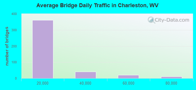
- 5,199,565Total average daily traffic
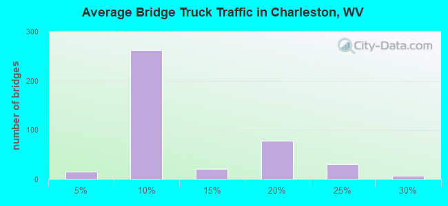
- 748,147Total average daily truck traffic
- National Bridge Inventory (NBI) Registered Bridges for Charleston
- No street view available for this location
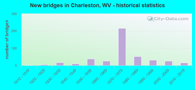
- New bridges - historical statistics
- 21910-1919
- 61920-1929
- 171930-1939
- 111940-1949
- 381950-1959
- 271960-1969
- 2161970-1979
- 531980-1989
- 311990-1999
- 272000-2009
- 162010-2019
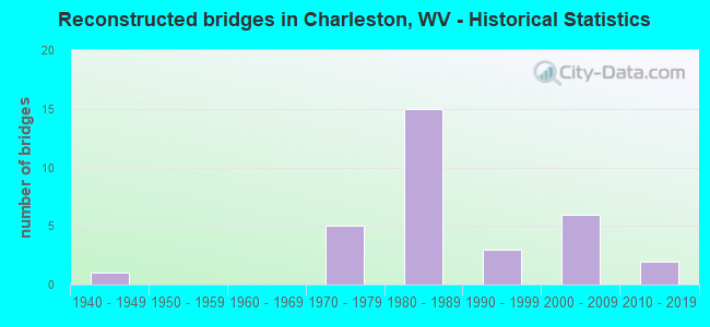
- Reconstructed bridges - Historical Statistics
- 11940-1949
- 01950-1959
- 01960-1969
- 51970-1979
- 151980-1989
- 31990-1999
- 62000-2009
- 22010-2019
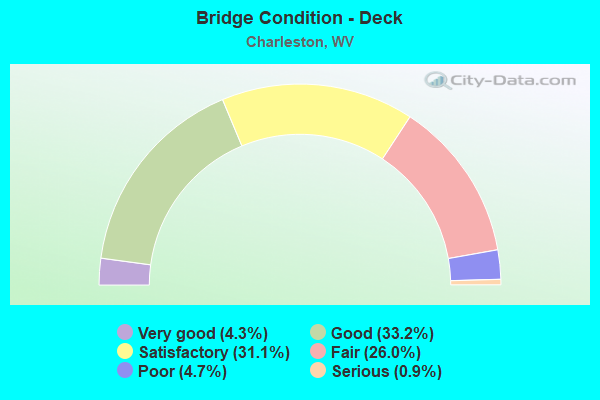
- Bridge Condition - Deck
- 4.3%Very good
- 33.2%Good
- 31.1%Satisfactory
- 26.0%Fair
- 4.7%Poor
- 0.9%Serious
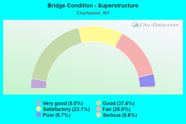
- Bridge Condition - Superstructure
- 5.0%Very good
- 37.4%Good
- 23.1%Satisfactory
- 26.9%Fair
- 6.7%Poor
- 0.8%Serious
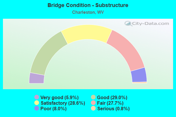
- Bridge Condition - Substructure
- 5.9%Very good
- 29.0%Good
- 28.6%Satisfactory
- 27.7%Fair
- 8.0%Poor
- 0.8%Serious
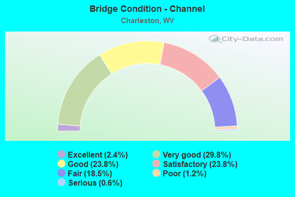
- Bridge Condition - Channel
- 2.4%Excellent
- 29.8%Very good
- 23.8%Good
- 23.8%Satisfactory
- 18.5%Fair
- 1.2%Poor
- 0.6%Serious
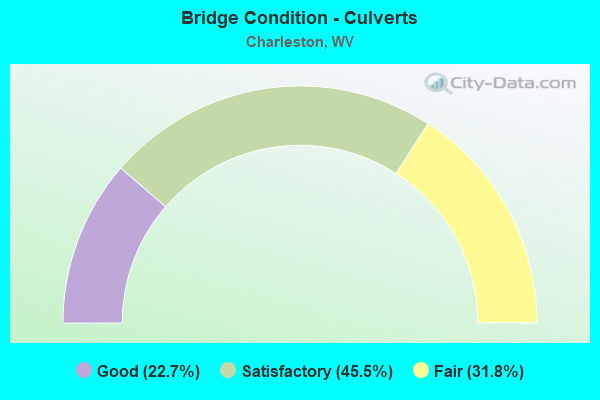
- Bridge Condition - Culverts
- 22.7%Good
- 45.5%Satisfactory
- 31.8%Fair
Find on map >> Show street view
Structure Number: 20A532, Location: 0.05 MI W OF WV 61 (Lat: 38.351961, Lng: -81.647719), Route carried "under" structure: Spur US 119, Year Built: 1975, Structure Length: 0. m, Average Daily Traffic: 18,000 (year 2010), Truck Traffic: 5%, Features Intersected: US 119 SPUR, Facility Carried by Structure: CSX RR CA 454.3
Minimum Vertical Clearance: 4.98m (16.34ft), Kilometerpoint: 0.402, Lanes under structure: 4, Material/Design: Steel, Design/Construction: Stringer/Multi-beam, Length of Maximum Span: 14.4m (47.2ft)
Find on map >> Show street view
Structure Number: 20A533, Location: 0.63 MI N OF CR 214/2 (Lat: 38.349339, Lng: -81.649961), Route carried "under" structure: Spur US 11900, Year Built: 1975, Structure Length: 0. m, Average Daily Traffic: 14,996 (year 0015), Truck Traffic: 5%, Features Intersected: US 119 SPUR NB&SB, Facility Carried by Structure: US 119 NORTH
Minimum Vertical Clearance: 5.21m (17.09ft), Kilometerpoint: 0.048, Lanes on structure: 1, Lanes under structure: 2, Length of Maximum Span: 39.6m (129.9ft)
Find on map >> Show street view
Structure Number: 20A534, Location: 2.14 MI E OF CR 60/64 (Lat: 38.354019, Lng: -81.649839), Route carried "under" structure: State highway 6100, Year Built: 1975, Structure Length: 0. m, Average Daily Traffic: 26,700 (year 2010), Truck Traffic: 5%, Features Intersected: WV61 & CSX RAILROAD, Facility Carried by Structure: I-64 RAMP D
Minimum Vertical Clearance: 16.76m (54.99ft), Kilometerpoint: 43.259, Lanes on structure: 1, Lanes under structure: 4, Length of Maximum Span: 33.2m (108.9ft)
Find on map >> Show street view
Structure Number: 20A536, Location: 0.95 MI N OF US 119 (Lat: 38.409039, Lng: -81.577100), Route carried "under" structure: Interstate 7900, Year Built: 1976, Structure Length: 0. m, Average Daily Traffic: 17,600 (year 2020), Truck Traffic: 17%, Features Intersected: I 79 NB/SB, Facility Carried by Structure: CR 119/13
Minimum Vertical Clearance: 5.44m (17.85ft), Kilometerpoint: 5.649, Lanes on structure: 2, Lanes under structure: 5, Length of Maximum Span: 41.1m (134.8ft)
Find on map >> Show street view
Structure Number: 20A563, Location: 0.02 MI S OF US 60 (Lat: 38.300689, Lng: -81.556411), Route carried "under" structure: County highway 6012, Year Built: 1945, Structure Length: 0. m, Average Daily Traffic: 1,400 (year 2019), Truck Traffic: 5%, Features Intersected: CR 60/12, Facility Carried by Structure: N&S RR-OWNER131.70
Minimum Vertical Clearance: 4.14m (13.58ft), Kilometerpoint: 9.495, Lanes under structure: 4, Material/Design: Steel, Design/Construction: Stringer/Multi-beam, Length of Maximum Span: 11.2m (36.7ft)
Find on map >> Show street view
Structure Number: 20A633, Location: 0.89 MI S OF WV61 (Lat: 38.297789, Lng: -81.565550), Route carried "under" structure: State highway 6100, Year Built: 1983, Structure Length: 0. m, Average Daily Traffic: 14,000 (year 0010), Truck Traffic: 5%, Features Intersected: Route 61, Facility Carried by Structure: I-77
Minimum Vertical Clearance: 4.57m (14.99ft), Kilometerpoint: 33.008, Lanes on structure: 4, Lanes under structure: 2, Toll: On Interstate toll segment, Length of Maximum Span: 30.2m (99.1ft)
Structure Number: 20A637, Location: 0.26 MI S OF WV 61, Route carried "under" structure: Ramp Interstate 7700, Year Built: 1983, Structure Length: 0. m, Average Daily Traffic: 9,000 (year 0004), Truck Traffic: 13%, Features Intersected: I-77 NB ROADWAY RAMPS, Facility Carried by Structure: I-77 NB
Minimum Vertical Clearance: 5.11m (16.77ft), Kilometerpoint: 151.809, Lanes on structure: 3, Lanes under structure: 2, Toll: On Interstate toll segment, Length of Maximum Span: 25.5m (83.7ft)
Minimum Vertical Clearance: 5.11m (16.77ft), Kilometerpoint: 151.809, Lanes on structure: 3, Lanes under structure: 2, Toll: On Interstate toll segment, Length of Maximum Span: 25.5m (83.7ft)
Structure Number: 20A638, Location: 0.26 MI S OF WV 61, Route carried "under" structure: Ramp Interstate 7700, Year Built: 1983, Structure Length: 0. m, Average Daily Traffic: 9,000 (year 0004), Truck Traffic: 13%, Features Intersected: NORTHBOUND ROADWAY RAMPS, Facility Carried by Structure: I-77 SB
Minimum Vertical Clearance: 5.13m (16.83ft), Kilometerpoint: 151.809, Lanes on structure: 2, Lanes under structure: 2, Toll: On Interstate toll segment, Length of Maximum Span: 25.5m (83.7ft)
Minimum Vertical Clearance: 5.13m (16.83ft), Kilometerpoint: 151.809, Lanes on structure: 2, Lanes under structure: 2, Toll: On Interstate toll segment, Length of Maximum Span: 25.5m (83.7ft)
Structure Number: 20A639, Location: 0.08 MI N OF RT 61 I/C, Route carried "under" structure: US 6000, Year Built: 1983, Structure Length: 0. m, Average Daily Traffic: 24,000 (year 0004), Truck Traffic: 5%, Features Intersected: KANAWHA RIVER AND RT. 60, Facility Carried by Structure: I-77 NB
Minimum Vertical Clearance: 4.98m (16.34ft), Kilometerpoint: 36.596, Lanes on structure: 2, Lanes under structure: 4, Toll: On Interstate toll segment, Length of Maximum Span: 144.5m (474.1ft)
Minimum Vertical Clearance: 4.98m (16.34ft), Kilometerpoint: 36.596, Lanes on structure: 2, Lanes under structure: 4, Toll: On Interstate toll segment, Length of Maximum Span: 144.5m (474.1ft)
Structure Number: 20A639, Location: 0.08 MI N OF RT 61 I/C, Route carried "under" structure: State highway 6100, Year Built: 1983, Structure Length: 0. m, Average Daily Traffic: 14,000 (year 0004), Truck Traffic: 5%, Features Intersected: KANAWHA RIVER AND RT. 60, Facility Carried by Structure: I-77 NB
Minimum Vertical Clearance: 8.15m (26.74ft), Kilometerpoint: 34.327, Lanes on structure: 2, Lanes under structure: 4, Toll: On Interstate toll segment, Length of Maximum Span: 144.5m (474.1ft)
Minimum Vertical Clearance: 8.15m (26.74ft), Kilometerpoint: 34.327, Lanes on structure: 2, Lanes under structure: 4, Toll: On Interstate toll segment, Length of Maximum Span: 144.5m (474.1ft)
Structure Number: 20A639, Location: 0.08 MI N OF RT 61 I/C, Route carried "under" structure: County highway 6029, Year Built: 1983, Structure Length: 0. m, Average Daily Traffic: 4,000 (year 0004), Truck Traffic: 8%, Features Intersected: KANAWHA RIVER AND RT. 60, Facility Carried by Structure: I-77 NB
Minimum Vertical Clearance: 12.22m (40.09ft), Kilometerpoint: 0.418, Lanes on structure: 2, Lanes under structure: 2, Toll: On Interstate toll segment, Length of Maximum Span: 144.5m (474.1ft)
Minimum Vertical Clearance: 12.22m (40.09ft), Kilometerpoint: 0.418, Lanes on structure: 2, Lanes under structure: 2, Toll: On Interstate toll segment, Length of Maximum Span: 144.5m (474.1ft)
Structure Number: 20A639, Location: 0.08 MI N OF RT 61 I/C, Route carried "under" structure: Ramp Interstate 7700, Year Built: 1983, Structure Length: 0. m, Average Daily Traffic: 9,000 (year 0004), Truck Traffic: 13%, Features Intersected: KANAWHA RIVER AND RT. 60, Facility Carried by Structure: I-77 NB
Minimum Vertical Clearance: 8.00m (26.25ft), Kilometerpoint: 152.357, Lanes on structure: 2, Lanes under structure: 1, Toll: On Interstate toll segment, Length of Maximum Span: 144.5m (474.1ft)
Minimum Vertical Clearance: 8.00m (26.25ft), Kilometerpoint: 152.357, Lanes on structure: 2, Lanes under structure: 1, Toll: On Interstate toll segment, Length of Maximum Span: 144.5m (474.1ft)
Structure Number: 20A639, Location: 0.08 MI N OF RT 61 I/C, Route carried "under" structure: Ramp Interstate 7700, Year Built: 1983, Structure Length: 0. m, Average Daily Traffic: 9,000 (year 0004), Truck Traffic: 13%, Features Intersected: KANAWHA RIVER AND RT. 60, Facility Carried by Structure: I-77 NB
Minimum Vertical Clearance: 5.49m (18.01ft), Kilometerpoint: 152.196, Lanes on structure: 2, Lanes under structure: 2, Toll: On Interstate toll segment, Length of Maximum Span: 144.5m (474.1ft)
Minimum Vertical Clearance: 5.49m (18.01ft), Kilometerpoint: 152.196, Lanes on structure: 2, Lanes under structure: 2, Toll: On Interstate toll segment, Length of Maximum Span: 144.5m (474.1ft)
Find on map >> Show street view
Structure Number: 20A64, Location: 0.18 MI. N OF WV 61 I/C (Lat: 38.309811, Lng: -81.561231), Route carried "under" structure: US 6000, Year Built: 1954, Structure Length: 0. m, Average Daily Traffic: 23,000 (year 0004), Truck Traffic: 5%, Features Intersected: Kanawha River, Facility Carried by Structure: I-77 SB
Minimum Vertical Clearance: 5.05m (16.57ft), Kilometerpoint: 36.596, Lanes on structure: 2, Lanes under structure: 4, Toll: On Interstate toll segment, Length of Maximum Span: 144.5m (474.1ft)
Find on map >> Show street view
Structure Number: 20A64, Location: 0.18 MI. N OF WV 61 I/C (Lat: 38.309811, Lng: -81.561231), Route carried "under" structure: Ramp Interstate 7700, Year Built: 1954, Structure Length: 0. m, Average Daily Traffic: 6,000 (year 0004), Truck Traffic: 13%, Features Intersected: Kanawha River, Facility Carried by Structure: I-77 SB
Minimum Vertical Clearance: 4.62m (15.16ft), Kilometerpoint: 152.244, Lanes on structure: 2, Lanes under structure: 2, Toll: On Interstate toll segment, Length of Maximum Span: 144.5m (474.1ft)
Find on map >> Show street view
Structure Number: 20A64, Location: 0.18 MI. N OF WV 61 I/C (Lat: 38.309811, Lng: -81.561231), Route carried "under" structure: Ramp Interstate 7700, Year Built: 1954, Structure Length: 0. m, Average Daily Traffic: 6,000 (year 0004), Truck Traffic: 13%, Features Intersected: Kanawha River, Facility Carried by Structure: I-77 SB
Minimum Vertical Clearance: 6.83m (22.41ft), Kilometerpoint: 152.244, Lanes on structure: 2, Lanes under structure: 1, Toll: On Interstate toll segment, Length of Maximum Span: 144.5m (474.1ft)
Find on map >> Show street view
Structure Number: 20A64, Location: 0.18 MI. N OF WV 61 I/C (Lat: 38.309811, Lng: -81.561231), Route carried "under" structure: County highway 6029, Year Built: 1954, Structure Length: 0. m, Average Daily Traffic: 4,000 (year 0004), Truck Traffic: 8%, Features Intersected: Kanawha River, Facility Carried by Structure: I-77 SB
Minimum Vertical Clearance: 12.22m (40.09ft), Kilometerpoint: 2.945, Lanes on structure: 2, Lanes under structure: 2, Toll: On Interstate toll segment, Length of Maximum Span: 144.5m (474.1ft)
Find on map >> Show street view
Structure Number: 20A64, Location: 0.18 MI. N OF WV 61 I/C (Lat: 38.309811, Lng: -81.561231), Route carried "under" structure: State highway 6100, Year Built: 1954, Structure Length: 0. m, Average Daily Traffic: 19,500 (year 0004), Truck Traffic: 5%, Features Intersected: Kanawha River, Facility Carried by Structure: I-77 SB
Minimum Vertical Clearance: 7.98m (26.18ft), Kilometerpoint: 34.327, Lanes on structure: 2, Lanes under structure: 4, Toll: On Interstate toll segment, Length of Maximum Span: 144.5m (474.1ft)
Structure Number: 20A641, Location: AT RT I/C, Route carried "under" structure: State highway 6100, Year Built: 1983, Structure Length: 0. m, Average Daily Traffic: 14,000 (year 0004), Truck Traffic: 5%, Features Intersected: ROUTE 61, Facility Carried by Structure: I-77 RAMP
Minimum Vertical Clearance: 5.11m (16.77ft), Kilometerpoint: 34.359, Lanes on structure: 2, Lanes under structure: 4, Toll: On Interstate toll segment, Length of Maximum Span: 26.8m (87.9ft)
Minimum Vertical Clearance: 5.11m (16.77ft), Kilometerpoint: 34.359, Lanes on structure: 2, Lanes under structure: 4, Toll: On Interstate toll segment, Length of Maximum Span: 26.8m (87.9ft)
Find on map >> Show street view
Structure Number: 20A643, Location: 0.25 MI S OF US 60 (Lat: 38.193000, Lng: -81.334000), Route carried "under" structure: US 6000, Year Built: 1975, Structure Length: 0. m, Average Daily Traffic: 12,000 (year 0007), Truck Traffic: 5%, Features Intersected: US60W,N&SRR,CAMPBELLS CK, Facility Carried by Structure: I-77 NB & SB
Minimum Vertical Clearance: 5.59m (18.34ft), Kilometerpoint: 0.241, Lanes on structure: 4, Lanes under structure: 2, Length of Maximum Span: 39.6m (129.9ft)
Find on map >> Show street view
Structure Number: 20A645, Location: 0.50 MI S OF US 60 (Lat: 38.317439, Lng: -81.556881), Route carried "under" structure: Ramp Interstate 7700, Year Built: 1975, Structure Length: 0. m, Average Daily Traffic: 2,688 (year 0012), Truck Traffic: 99%, Features Intersected: RAMP J (SIGNED RAMP A), Facility Carried by Structure: I-77 NB & SB
Minimum Vertical Clearance: 5.28m (17.32ft), Kilometerpoint: 153.435, Lanes on structure: 4, Lanes under structure: 2, Length of Maximum Span: 21.4m (70.2ft)
Find on map >> Show street view
Structure Number: 20A652, Location: 1.17 MI N OF WV 61 I/C (Lat: 38.315700, Lng: -81.559661), Route carried "under" structure: Alternate County highway 6029, Year Built: 1954, Structure Length: 0. m, Average Daily Traffic: 5,045 (year 0016), Truck Traffic: 13%, Features Intersected: CR 60/29 AND N&S RR, Facility Carried by Structure: I-77 BELLE RAMPS
Minimum Vertical Clearance: 8.33m (27.33ft), Kilometerpoint: 3.203, Lanes on structure: 4, Lanes under structure: 2, Length of Maximum Span: 16.3m (53.5ft)
Find on map >> Show street view
Structure Number: 20A653, Location: 1.23 MI N OF RT 61 (Lat: 38.315250, Lng: -81.560369), Route carried "under" structure: US 6000, Year Built: 1954, Structure Length: 0. m, Average Daily Traffic: 23,000 (year 0007), Truck Traffic: 5%, Features Intersected: US 60 EB & WB, Facility Carried by Structure: I-77 BELLE RAMPS
Minimum Vertical Clearance: 4.83m (15.85ft), Kilometerpoint: 36.033, Lanes on structure: 2, Lanes under structure: 4, Length of Maximum Span: 23.2m (76.1ft)
Find on map >> Show street view
Structure Number: 20A654, Location: 0.27 MI N OF WV 214 (Lat: 38.311750, Lng: -81.728619), Route carried "under" structure: State highway 21400, Year Built: 1986, Structure Length: 0. m, Average Daily Traffic: 549 (year 0017), Truck Traffic: 8%, Features Intersected: TRACE FK OF DAV CK,WV214, Facility Carried by Structure: US 119 NORTH
Minimum Vertical Clearance: 12.27m (40.26ft), Kilometerpoint: 8.240, Lanes on structure: 2, Lanes under structure: 2, Length of Maximum Span: 32.0m (105.0ft)
Find on map >> Show street view
Structure Number: 20A655, Location: 1.27 MI N OF WV 214 (Lat: 38.312081, Lng: -81.728611), Route carried "under" structure: State highway 21400, Year Built: 1986, Structure Length: 0. m, Average Daily Traffic: 856 (year 0010), Truck Traffic: 8%, Features Intersected: TRACE FK/DAVIS CK, WV214, Facility Carried by Structure: US 119 SOUTH
Minimum Vertical Clearance: 12.88m (42.26ft), Kilometerpoint: 8.240, Lanes on structure: 2, Lanes under structure: 2, Length of Maximum Span: 41.8m (137.1ft)
Find on map >> Show street view
Structure Number: 20A656, Location: 1.27 MI N OF WV 214 (Lat: 38.340381, Lng: -81.705161), Route carried "under" structure: ServiceOther road , Year Built: 1986, Structure Length: 0. m, Average Daily Traffic: 50 (year 0007), Features Intersected: DAVIS CREEK, Facility Carried by Structure: US 119 NORTH
Minimum Vertical Clearance: 9.14m (29.99ft), Kilometerpoint: 1429.097, Lanes on structure: 3, Lanes under structure: 1, Length of Maximum Span: 33.5m (109.9ft)
Find on map >> Show street view
Structure Number: 20A656, Location: 1.27 MI N OF WV 214 (Lat: 38.340381, Lng: -81.705161), Route carried "under" structure: ServiceOther road , Year Built: 1986, Structure Length: 0. m, Average Daily Traffic: 50 (year 0007), Features Intersected: DAVIS CREEK, Facility Carried by Structure: US 119 NORTH
Minimum Vertical Clearance: 9.14m (29.99ft), Kilometerpoint: 0.000, Lanes on structure: 3, Lanes under structure: 1, Length of Maximum Span: 33.5m (109.9ft)
Find on map >> Show street view
Structure Number: 20A657, Location: 1.27 MI N OF WV 214 (Lat: 38.340589, Lng: -81.705300), Route carried "under" structure: ServiceOther road , Year Built: 1986, Structure Length: 0. m, Average Daily Traffic: 50 (year 0010), Features Intersected: DAVIS CREEK, Facility Carried by Structure: US 119 SOUTH
Minimum Vertical Clearance: 8.84m (29.00ft), Kilometerpoint: 0.000, Lanes on structure: 3, Lanes under structure: 1, Length of Maximum Span: 33.5m (109.9ft)
Find on map >> Show street view
Structure Number: 20A657, Location: 1.27 MI N OF WV 214 (Lat: 38.340589, Lng: -81.705300), Route carried "under" structure: ServiceOther road , Year Built: 1986, Structure Length: 0. m, Average Daily Traffic: 20 (year 0007), Features Intersected: DAVIS CREEK, Facility Carried by Structure: US 119 SOUTH
Minimum Vertical Clearance: 9.58m (31.43ft), Kilometerpoint: 0.000, Lanes on structure: 3, Lanes under structure: 1, Length of Maximum Span: 33.5m (109.9ft)
Find on map >> Show street view
Structure Number: 20A658, Location: 1.47 MI N OF WV 214 (Lat: 38.341000, Lng: -81.701000), Route carried "under" structure: State highway 60100, Year Built: 1985, Structure Length: 0. m, Average Daily Traffic: 18,706 (year 0017), Truck Traffic: 5%, Features Intersected: WV 601 JEFFERSON ROAD, Facility Carried by Structure: US 119 NORTH
Minimum Vertical Clearance: 5.08m (16.67ft), Kilometerpoint: 0.048, Lanes on structure: 2, Lanes under structure: 5, Length of Maximum Span: 41.4m (135.8ft)
Find on map >> Show street view
Structure Number: 20A659, Location: 1.49 MI N OF WV 214 (F) (Lat: 38.341489, Lng: -81.701461), Route carried "under" structure: State highway 60100, Year Built: 1985, Structure Length: 0. m, Average Daily Traffic: 17,400 (year 0007), Truck Traffic: 5%, Features Intersected: WV 601 JEFFERSON ROAD, Facility Carried by Structure: US 119
Minimum Vertical Clearance: 5.08m (16.67ft), Kilometerpoint: 0.048, Lanes on structure: 2, Lanes under structure: 5, Length of Maximum Span: 40.4m (132.5ft)
Find on map >> Show street view
Structure Number: 20A68, Location: 0.01 MI W OF CR 73 (Lat: 38.309692, Lng: -81.556639), Route carried "under" structure: City street , Year Built: 1992, Structure Length: 0. m, Average Daily Traffic: 250 (year 0012), Truck Traffic: 5%, Features Intersected: KANAWHA RR & AMHERST DR, Facility Carried by Structure: US 60
Minimum Vertical Clearance: 8.23m (27.00ft), Kilometerpoint: 0.000, Lanes on structure: 2, Lanes under structure: 2, Length of Maximum Span: 19.2m (63.0ft)
Find on map >> Show street view
Structure Number: 20A684, Location: 0.48 MI S OF WV 94 (Lat: 38.237931, Lng: -81.555531), Route carried "under" structure: State highway 61, Year Built: 1993, Structure Length: 0. m, Average Daily Traffic: 3,900 (year 2019), Truck Traffic: 6%, Features Intersected: WV 61, Facility Carried by Structure: KRT COAL CONV #
Minimum Vertical Clearance: 7.01m (23.00ft), Kilometerpoint: 25.556, Lanes under structure: 2, Material/Design: Steel, Length of Maximum Span: 22.9m (75.1ft)
Find on map >> Show street view
Structure Number: 20A754, Location: 0.13 MI N OF CR 622/24 (Lat: 38.413431, Lng: -81.796431), Route carried "under" structure: Interstate 6400, Year Built: 1998, Structure Length: 0. m, Average Daily Traffic: 62,059 (year 2017), Truck Traffic: 17%, Features Intersected: I-64 EB & WB, Facility Carried by Structure: WV 622
Minimum Vertical Clearance: 4.95m (16.24ft), Kilometerpoint: 76.347, Lanes on structure: 5, Lanes under structure: 6, Length of Maximum Span: 30.5m (100.1ft)
Find on map >> Show street view
Structure Number: 20A777, Location: 0.69 E OF WV 25 (Lat: 38.429619, Lng: -81.824581), Route carried "under" structure: County highway 3501, Year Built: 2000, Structure Length: 0. m, Average Daily Traffic: 3,548 (year 2017), Truck Traffic: 8%, Features Intersected: ARMOUR CREEK AND CR 35/1, Facility Carried by Structure: I-64 WBL & EBL
Minimum Vertical Clearance: 4.55m (14.93ft), Kilometerpoint: 1.304, Lanes on structure: 6, Lanes under structure: 2, Length of Maximum Span: 23.8m (78.1ft)
Find on map >> Show street view
Structure Number: 20A779, Location: 2.82 MILE E OF WV 622 (Lat: 38.387600, Lng: -81.768269), Route carried "under" structure: Ramp Interstate 6400, Year Built: 1965, Structure Length: 0. m, Average Daily Traffic: 9,500 (year 0008), Truck Traffic: 17%, Features Intersected: I-64 RAMPS C & D, Facility Carried by Structure: I-64 EBL
Minimum Vertical Clearance: 4.32m (14.17ft), Kilometerpoint: 0.016, Lanes on structure: 3, Lanes under structure: 2, Length of Maximum Span: 19.1m (62.7ft)
Find on map >> Show street view
Structure Number: 20A781, Location: 0.53 MI EAST OF WV 25 (Lat: 38.377000, Lng: -81.755000), Route carried "under" structure: County highway 2513, Year Built: 1966, Structure Length: 0. m, Average Daily Traffic: 98 (year 0017), Features Intersected: CR 25/13, Facility Carried by Structure: I-64 EAST & WEST
Minimum Vertical Clearance: 4.37m (14.34ft), Kilometerpoint: 0.032, Lanes on structure: 7, Lanes under structure: 2, Length of Maximum Span: 14.0m (45.9ft)
Find on map >> Show street view
Structure Number: 20A782, Location: 2.54 MILE E OF WV 622 (Lat: 38.387761, Lng: -81.768139), Route carried "under" structure: Ramp Interstate 6400, Year Built: 1965, Structure Length: 0. m, Average Daily Traffic: 18,775 (year 0007), Truck Traffic: 17%, Features Intersected: I-64 RAMPS C & D, Facility Carried by Structure: I-64 WBL
Minimum Vertical Clearance: 4.32m (14.17ft), Kilometerpoint: 0.161, Lanes on structure: 3, Lanes under structure: 2, Length of Maximum Span: 19.1m (62.7ft)
Find on map >> Show street view
Structure Number: 20A804, Location: 0.33 MIL E OF CR 25/25 (Lat: 38.361200, Lng: -81.732150), Route carried "under" structure: City street , Year Built: 1970, Structure Length: 0. m, Average Daily Traffic: 5,000 (year 0007), Truck Traffic: 8%, Features Intersected: WESTMORELAND DRIVE, Facility Carried by Structure: I- 64 EB & WB
Minimum Vertical Clearance: 4.60m (15.09ft), Kilometerpoint: 0.000, Lanes on structure: 6, Lanes under structure: 2, Length of Maximum Span: 13.5m (44.3ft)
Find on map >> Show street view
Structure Number: 20A818, Location: 2.58 MIL NORTH OF WV 622 (Lat: 38.544000, Lng: -81.637000), Route carried "under" structure: County highway 2117, Year Built: 2007, Structure Length: 0. m, Average Daily Traffic: 20 (year 0010), Features Intersected: CR 21/17, Facility Carried by Structure: I-77 SB
Minimum Vertical Clearance: 4.88m (16.01ft), Kilometerpoint: 0.129, Lanes on structure: 2, Lanes under structure: 2, Length of Maximum Span: 41.7m (136.8ft)
Find on map >> Show street view
Structure Number: 20A901, Location: 0.27 MI S OF US 60 (Lat: 38.347586, Lng: -81.636006), Route carried "under" structure: City street , Year Built: 1936, Structure Length: 0. m, Average Daily Traffic: 22,000 (year 0004), Truck Traffic: 5%, Features Intersected: WV 61, KANAWHA R, CSX, Facility Carried by Structure: DICKINSON STREET
Minimum Vertical Clearance: 5.18m (16.99ft), Kilometerpoint: 0.000, Lanes on structure: 4, Lanes under structure: 4, Length of Maximum Span: 128.0m (419.9ft)
Find on map >> Show street view
Structure Number: 20A901, Location: 0.27 MI S OF US 60 (Lat: 38.179517, Lng: -81.637794), Route carried "under" structure: State highway 6100, Year Built: 1936, Structure Length: 0. m, Average Daily Traffic: 17,260 (year 0004), Truck Traffic: 8%, Features Intersected: WV 61, KANAWHA R, CSX, Facility Carried by Structure: DICKINSON STREET
Minimum Vertical Clearance: 4.65m (15.26ft), Kilometerpoint: 42.117, Lanes on structure: 4, Lanes under structure: 4, Length of Maximum Span: 128.0m (419.9ft)
Find on map >> Show street view
Structure Number: 20A904, Location: 0.01 MI E OF I-64 (Lat: 38.356511, Lng: -81.643039), Route carried "under" structure: City street , Year Built: 1955, Structure Length: 0. m, Average Daily Traffic: 10 (year 0007), Features Intersected: COLUMBIA AVE & ELK RIVER, Facility Carried by Structure: QUARRIER STREET
Minimum Vertical Clearance: 2.95m (9.68ft), Kilometerpoint: 0.080, Lanes on structure: 4, Lanes under structure: 2, Length of Maximum Span: 70.1m (230.0ft)
Find on map >> Show street view
Structure Number: 20A91, Location: 0.03 MI S OF WV 61 (Lat: 38.337981, Lng: -81.629519), Route carried "under" structure: ServiceCity street N0280, Year Built: 1965, Structure Length: 0. m, Features Intersected: PORTER ROAD, Facility Carried by Structure: CSX RR OWNER #4529
Minimum Vertical Clearance: 4.67m (15.32ft), Kilometerpoint: 0.161, Lanes under structure: 2, Length of Maximum Span: 12.2m (40.0ft)
Find on map >> Show street view
Structure Number: 20A911, Location: 0.02 MI S OF US 60 (Lat: 38.368219, Lng: -81.659261), Route carried "under" structure: ServiceCity street N0280, Year Built: 1930, Structure Length: 0. m, Features Intersected: FLORIDA STREET, Facility Carried by Structure: N&S RR OWN# 123.82
Minimum Vertical Clearance: 4.24m (13.91ft), Kilometerpoint: 0.177, Lanes under structure: 2, Length of Maximum Span: 1.6m (5.2ft)
Find on map >> Show street view
Structure Number: 20A912, Location: 0.63 MIL N. OF WV 114 (Lat: 38.349281, Lng: -81.618489), Route carried "under" structure: ServiceCity street , Year Built: 1975, Structure Length: 0. m, Average Daily Traffic: 75 (year 0009), Features Intersected: I-77, PIEDMONT, RICHARDS, Facility Carried by Structure: FARNSWORTH DRIVE
Minimum Vertical Clearance: 5.13m (16.83ft), Kilometerpoint: 0.032, Lanes on structure: 2, Lanes under structure: 2, Length of Maximum Span: 45.4m (149.0ft)
Find on map >> Show street view
Structure Number: 20A912, Location: 0.63 MIL N. OF WV 114 (Lat: 38.349281, Lng: -81.618489), Route carried "under" structure: Interstate 7700, Year Built: 1975, Structure Length: 0. m, Average Daily Traffic: 42,291 (year 0015), Truck Traffic: 17%, Features Intersected: I-77, PIEDMONT, RICHARDS, Facility Carried by Structure: FARNSWORTH DRIVE
Minimum Vertical Clearance: 6.12m (20.08ft), Kilometerpoint: 160.934, Lanes on structure: 2, Lanes under structure: 3, Length of Maximum Span: 45.4m (149.0ft)
Find on map >> Show street view
Structure Number: 20A912, Location: 0.63 MIL N. OF WV 114 (Lat: 38.349281, Lng: -81.618489), Route carried "under" structure: Interstate 7700, Year Built: 1975, Structure Length: 0. m, Average Daily Traffic: 34,724 (year 0013), Truck Traffic: 17%, Features Intersected: I-77, PIEDMONT, RICHARDS, Facility Carried by Structure: FARNSWORTH DRIVE
Minimum Vertical Clearance: 5.39m (17.68ft), Kilometerpoint: 160.934, Lanes on structure: 2, Lanes under structure: 3, Length of Maximum Span: 45.4m (149.0ft)
Find on map >> Show street view
Structure Number: 20A912, Location: 0.63 MIL N. OF WV 114 (Lat: 38.349281, Lng: -81.618489), Route carried "under" structure: ServiceCity street , Year Built: 1975, Structure Length: 0. m, Average Daily Traffic: 4,000 (year 0009), Truck Traffic: 5%, Features Intersected: I-77, PIEDMONT, RICHARDS, Facility Carried by Structure: FARNSWORTH DRIVE
Minimum Vertical Clearance: 6.68m (21.92ft), Kilometerpoint: 1.207, Lanes on structure: 2, Lanes under structure: 2, Length of Maximum Span: 45.4m (149.0ft)
Find on map >> Show street view
Structure Number: 20A913, Location: 0.03 MI SOUTH OF WV (Lat: 38.333611, Lng: -81.622169), Route carried "under" structure: ServiceCity street N0280, Year Built: 1963, Structure Length: 0. m, Features Intersected: SOUTH RUFFNER ROAD, Facility Carried by Structure: CSX RR OWNER#4524
Minimum Vertical Clearance: 4.42m (14.50ft), Kilometerpoint: 0.209, Lanes under structure: 2, Material/Design: Steel, Design/Construction: Stringer/Multi-beam, Length of Maximum Span: 10.9m (35.8ft)
Find on map >> Show street view
Structure Number: 20A914, Location: 0.03 MI S OF WV 61 (Lat: 38.328119, Lng: -81.604861), Route carried "under" structure: ServiceCity street N0280, Year Built: 1965, Structure Length: 0. m, Features Intersected: 31ST STREET, Facility Carried by Structure: CSX RR OWNER #4514
Minimum Vertical Clearance: 4.37m (14.34ft), Kilometerpoint: 0.225, Lanes under structure: 2, Material/Design: Steel, Design/Construction: Stringer/Multi-beam, Length of Maximum Span: 11.0m (36.1ft)
Find on map >> Show street view
Structure Number: 20A915, Location: 0.26 MI NORTH OF US 60 (Lat: 38.355061, Lng: -81.629631), Route carried "under" structure: ServiceCity street N0280, Year Built: 1975, Structure Length: 0. m, Average Daily Traffic: 3,017 (year 2013), Truck Traffic: 8%, Features Intersected: COURT STREET, Facility Carried by Structure: N&S RAILROAD
Minimum Vertical Clearance: 4.90m (16.08ft), Kilometerpoint: 0.241, Lanes under structure: 2, Length of Maximum Span: 27.3m (89.6ft)
Find on map >> Show street view
Structure Number: 20A916, Location: 0.05 MI NORTH OF US 60 (Lat: 38.334750, Lng: -81.596469), Route carried "under" structure: ServiceCity street N0280, Year Built: 1975, Structure Length: 0. m, Features Intersected: WERTZ AVENUE, Facility Carried by Structure: N&S RAILROAD
Minimum Vertical Clearance: 4.22m (13.85ft), Kilometerpoint: 0.257, Lanes under structure: 2, Length of Maximum Span: 11.3m (37.1ft)
Find on map >> Show street view
Structure Number: 20A921, Location: 0.10 MI S OF US 60 (Lat: 38.388539, Lng: -81.833989), Route carried "under" structure: County highway 606, Year Built: 1929, Structure Length: 0. m, Average Daily Traffic: 10,818 (year 0015), Truck Traffic: 8%, Features Intersected: CR 6/6, Facility Carried by Structure: THIRD AVENUE
Minimum Vertical Clearance: 3.35m (10.99ft), Kilometerpoint: 9.817, Lanes on structure: 2, Lanes under structure: 2, Length of Maximum Span: 8.0m (26.2ft)
Find on map >> Show street view
Structure Number: 20A922, Location: 0.12 MI S OF US 60 (Lat: 38.388000, Lng: -81.834200), Route carried "under" structure: County highway 606, Year Built: 1929, Structure Length: 0. m, Average Daily Traffic: 10,818 (year 0015), Truck Traffic: 8%, Features Intersected: CR 6/6, Facility Carried by Structure: FOURTH AVENUE
Minimum Vertical Clearance: 3.35m (10.99ft), Kilometerpoint: 9.801, Lanes on structure: 2, Lanes under structure: 2, Length of Maximum Span: 8.0m (26.2ft)
Find on map >> Show street view
Structure Number: 20A926, Location: 0.20 MI E OF US 60 (Lat: 38.366231, Lng: -81.652231), Route carried "under" structure: City street N0280, Year Built: 1974, Structure Length: 0. m, Average Daily Traffic: 2,300 (year 2019), Truck Traffic: 3%, Features Intersected: VIRGINIA STREET, Facility Carried by Structure: N&S RAILROAD
Minimum Vertical Clearance: 4.67m (15.32ft), Kilometerpoint: 0.306, Lanes under structure: 2, Length of Maximum Span: 17.6m (57.7ft)
Find on map >> Show street view
Structure Number: 40A073, Location: 4.82 MI E OF WV 34 (Lat: 38.448131, Lng: -81.849111), Route carried "under" structure: Interstate 6400, Year Built: 1962, Structure Length: 0. m, Average Daily Traffic: 49,900 (year 0020), Truck Traffic: 24%, Features Intersected: I-64 EB & WB, Facility Carried by Structure: I-64 ACCESS RAMP
Minimum Vertical Clearance: 4.80m (15.75ft), Kilometerpoint: 70.006, Lanes on structure: 2, Lanes under structure: 4, Length of Maximum Span: 29.9m (98.1ft)
Find on map >> Show street view
Structure Number: 40A147, Location: 0.37 MILE S. OF WV 34 (Lat: 38.477000, Lng: -81.923000), Route carried "under" structure: County highway 2902, Year Built: 2008, Structure Length: 0. m, Average Daily Traffic: 10 (year 0017), Features Intersected: KILGORE RD. CR 29/2, Facility Carried by Structure: US 35 NB & SB
Minimum Vertical Clearance: 4.37m (14.34ft), Kilometerpoint: 0.016, Lanes on structure: 5, Lanes under structure: 2, Length of Maximum Span: 8.5m (27.9ft)
Find on map >> Show street view
Structure Number: 40A148, Location: 0.04 MILE N. OF US 35 SPU (Lat: 38.453839, Lng: -81.903519), Route carried "under" structure: Interstate 6400, Year Built: 2008, Structure Length: 0. m, Average Daily Traffic: 64,200 (year 0007), Truck Traffic: 24%, Features Intersected: I-64 EB & WB, Facility Carried by Structure: US 35 NB
Minimum Vertical Clearance: 5.23m (17.16ft), Kilometerpoint: 65.114, Lanes on structure: 3, Lanes under structure: 6, Length of Maximum Span: 50.6m (166.0ft)
Find on map >> Show street view
Structure Number: 40A149, Location: 0.04 MI N OF US 35 SPUR (Lat: 38.453939, Lng: -81.903811), Route carried "under" structure: Interstate 6400, Year Built: 2008, Structure Length: 0. m, Average Daily Traffic: 44,000 (year 0011), Truck Traffic: 24%, Features Intersected: I-64 EB & WB, Facility Carried by Structure: US 35 SB
Minimum Vertical Clearance: 5.23m (17.16ft), Kilometerpoint: 65.114, Lanes on structure: 2, Lanes under structure: 6, Length of Maximum Span: 50.6m (166.0ft)
Find on map >> Show street view
Structure Number: 40A15, Location: 0.02 MILE N OF US 35 SPUR (Lat: 38.453700, Lng: -81.903600), Route carried "under" structure: US 350, Year Built: 2008, Structure Length: 0. m, Average Daily Traffic: 1,600 (year 0007), Truck Traffic: 13%, Features Intersected: I64 E&W, US35N&S & RAMPS, Facility Carried by Structure: US 35 RAMP 5
Minimum Vertical Clearance: 5.46m (17.91ft), Kilometerpoint: 0.064, Lanes on structure: 1, Lanes under structure: 5, Length of Maximum Span: 76.2m (250.0ft)
Find on map >> Show street view
Structure Number: 40A15, Location: 0.02 MILE N OF US 35 SPUR (Lat: 38.453700, Lng: -81.903600), Route carried "under" structure: Interstate 640, Year Built: 2008, Structure Length: 0. m, Average Daily Traffic: 2,700 (year 0007), Truck Traffic: 24%, Features Intersected: I64 E&W, US35N&S & RAMPS, Facility Carried by Structure: US 35 RAMP 5
Minimum Vertical Clearance: 10.69m (35.07ft), Kilometerpoint: 65.082, Lanes on structure: 1, Lanes under structure: 6, Length of Maximum Span: 76.2m (250.0ft)
Find on map >> Show street view
Structure Number: 40A15, Location: 0.02 MILE N OF US 35 SPUR (Lat: 38.453700, Lng: -81.903600), Route carried "under" structure: Ramp Interstate 64, Year Built: 2008, Structure Length: 0. m, Average Daily Traffic: 1,600 (year 0007), Truck Traffic: 13%, Features Intersected: I64 E&W, US35N&S & RAMPS, Facility Carried by Structure: US 35 RAMP 5
Minimum Vertical Clearance: 7.24m (23.75ft), Kilometerpoint: 65.082, Lanes on structure: 1, Lanes under structure: 1, Length of Maximum Span: 76.2m (250.0ft)
Find on map >> Show street view
Structure Number: 40A15, Location: 0.02 MILE N OF US 35 SPUR (Lat: 38.453700, Lng: -81.903600), Route carried "under" structure: Ramp Interstate 64, Year Built: 2008, Structure Length: 0. m, Average Daily Traffic: 1,600 (year 0007), Truck Traffic: 13%, Features Intersected: I64 E&W, US35N&S & RAMPS, Facility Carried by Structure: US 35 RAMP 5
Minimum Vertical Clearance: 6.20m (20.34ft), Kilometerpoint: 65.082, Lanes on structure: 1, Lanes under structure: 1, Length of Maximum Span: 76.2m (250.0ft)
Find on map >> Show street view
Structure Number: 40A15, Location: 0.02 MILE N OF US 35 SPUR (Lat: 38.453700, Lng: -81.903600), Route carried "under" structure: Ramp Interstate 64, Year Built: 2008, Structure Length: 0. m, Average Daily Traffic: 1,600 (year 0007), Truck Traffic: 13%, Features Intersected: I64 E&W, US35N&S & RAMPS, Facility Carried by Structure: US 35 RAMP 5
Minimum Vertical Clearance: 5.97m (19.59ft), Kilometerpoint: 65.082, Lanes on structure: 1, Lanes under structure: 1, Length of Maximum Span: 76.2m (250.0ft)
Find on map >> Show street view
Structure Number: 40A162, Location: 0.09 MI N OF WV 817 (Lat: 38.532100, Lng: -81.895500), Route carried "under" structure: State highway 81700, Year Built: 2010, Structure Length: 0. m, Average Daily Traffic: 11,500 (year 0007), Truck Traffic: 6%, Features Intersected: WV 817, Facility Carried by Structure: WV 34
Minimum Vertical Clearance: 4.95m (16.24ft), Kilometerpoint: 17.075, Lanes on structure: 2, Lanes under structure: 4, Length of Maximum Span: 25.0m (82.0ft)