Bridge Statistics for Colorado Springs, Colorado (CO)
Condition, Traffic, Stress, Structural Evaluation, Project Costs
- National Bridge Inventory (NBI) Statistics
- 385Number of bridges
- 4,846ft / 1,477mTotal length
- $47,397,000Total costs
- 8,288,363Total average daily traffic
- 508,845Total average daily truck traffic
- National Bridge Inventory (NBI) Registered Bridges for Colorado Springs
- No street view available for this location
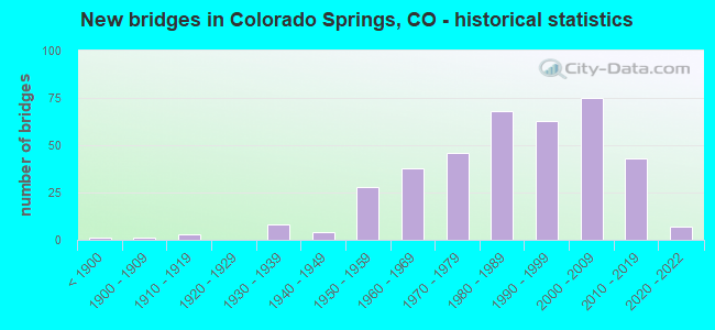
- New bridges - historical statistics
- 1Before 1900
- 11900-1909
- 31910-1919
- 81930-1939
- 41940-1949
- 281950-1959
- 381960-1969
- 461970-1979
- 681980-1989
- 631990-1999
- 752000-2009
- 432010-2019
- 72020-2022
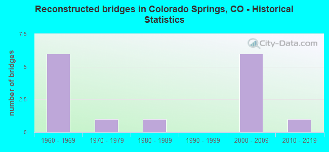
- Reconstructed bridges - Historical Statistics
- 61960-1969
- 11970-1979
- 11980-1989
- 01990-1999
- 62000-2009
- 12010-2019
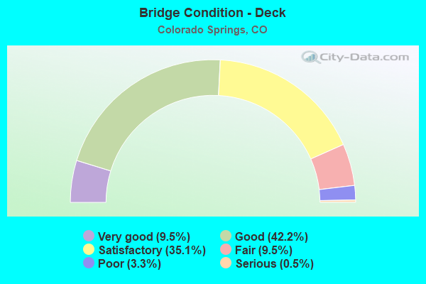
- Bridge Condition - Deck
- 9.5%Very good
- 42.2%Good
- 35.1%Satisfactory
- 9.5%Fair
- 3.3%Poor
- 0.5%Serious
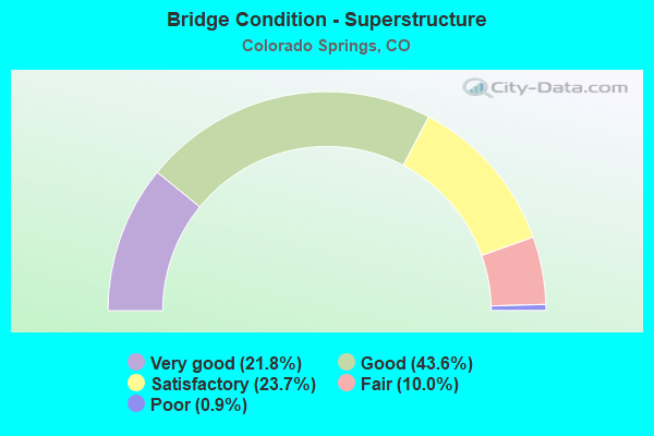
- Bridge Condition - Superstructure
- 21.8%Very good
- 43.6%Good
- 23.7%Satisfactory
- 10.0%Fair
- 0.9%Poor
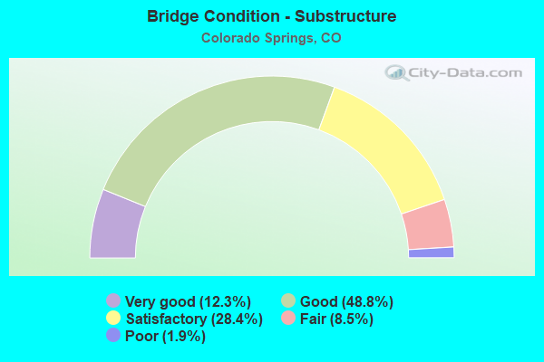
- Bridge Condition - Substructure
- 12.3%Very good
- 48.8%Good
- 28.4%Satisfactory
- 8.5%Fair
- 1.9%Poor
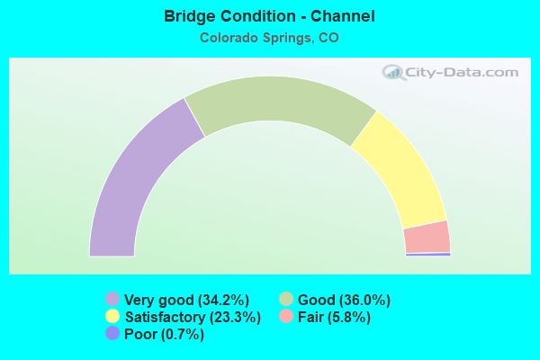
- Bridge Condition - Channel
- 34.2%Very good
- 36.0%Good
- 23.3%Satisfactory
- 5.8%Fair
- 0.7%Poor

- Bridge Condition - Culverts
- 3.5%Very good
- 18.1%Good
- 58.3%Satisfactory
- 16.7%Fair
- 3.5%Poor
Find on map >> Show street view
Structure Number: CSG-F.80-06.50A, Location: 0.1 MI S OF CHEYENNE RD (Lat: 38.802778, Lng: -104.834444), Route carried "on" structure: City street , Year Built: 1995, Status: Open, Structure Length: 1.07m (3.51ft), Average Daily Traffic: 8,300 (year 2021), Truck Traffic: 4%, Average Future Daily Traffic: 10,873 (year 2041), Design Load: HS 20, Features Intersected: CHEYENNE CREEK, Facility Carried by Structure: ALSACE WAY
Minimum Vertical Clearance: 30+ m (98+ ft), Kilometerpoint: 0.490, Lanes on structure: 2, Owner: City or Municipal Highway Agency, Approaching Roadway Width: 13.1m (43.0ft), Material/Design: Concrete, Design/Construction: Frame, Number Of Spans In Main Unit: 1, Length of Maximum Span: 9.8m (32.2ft), Curb or Sidewalk Widths: Left: 1.5m (4.9ft), Right: 1.5m (4.9ft), Curb-To-Curb Width: 9.1m (29.9ft), Out-to-Out Width: 13.1m (43.0ft)
Condition: Deck: Satisfactory, Superstructure: Satisfactory, Substructure: Good, Channel: Satisfactory, Operating Rating: 61.2 metric tons, Method Used To Determine Operating Rating: Load Factor (LF), Inventory Rating: 36.7 metric tons, Method Used To Determine Inventory Rating: Load Factor (LF), Structural Evaluation: Equal to present minimum criteria, Deck Geometry: High priority of corrective action, Waterway Adequacy: Equal to present desirable criteria, Approach Roadway Alignment: Equal to present desirable criteria, Designated Inspection Frequency: Every 24 months, Inspection Date: April 2020, Deck Structure Type: Concrete Cast-file-Place, Wearing Surface/Protective System: Wearing Surface: Bituminous
Find on map >> Show street view
Structure Number: CSG-F.84-12.00A, Location: 0.6 MI N OF FILLMORE (Lat: 38.883172, Lng: -104.834333), Route carried "on" structure: City street , Year Built: 1989, Status: Open, Structure Length: 1.00m (3.28ft), Average Daily Traffic: 2,475 (year 2021), Truck Traffic: 4%, Average Future Daily Traffic: 3,243 (year 2041), Design Load: HS 20, Features Intersected: S.DOUGLAS CREEK, Facility Carried by Structure: SINTON ROAD
Minimum Vertical Clearance: 30+ m (98+ ft), Kilometerpoint: 1.619, Lanes on structure: 3, Owner: City or Municipal Highway Agency, Approaching Roadway Width: 13.4m (44.0ft), Skew: 2 degrees, Material/Design: Concrete, Design/Construction: Frame, Number Of Spans In Main Unit: 1, Length of Maximum Span: 9.4m (30.8ft), Curb or Sidewalk Widths: Left: 2.1m (6.9ft), Right: 2.1m (6.9ft), Curb-To-Curb Width: 13.5m (44.3ft), Out-to-Out Width: 18.5m (60.7ft)
Condition: Deck: Fair, Superstructure: Fair, Substructure: Good, Channel: Good, Operating Rating: 38.4 metric tons, Method Used To Determine Operating Rating: Load Factor (LF), Inventory Rating: 23.0 metric tons, Method Used To Determine Inventory Rating: Load Factor (LF), Structural Evaluation: Somewhat better than minimum adequacy, Deck Geometry: Somewhat better than minimum adequacy, Waterway Adequacy: Equal to present desirable criteria, Approach Roadway Alignment: Equal to present minimum criteria, Designated Inspection Frequency: Every 24 months, Inspection Date: Febuary 2020, Deck Structure Type: Other, Wearing Surface/Protective System: Wearing Surface: Bituminous
Find on map >> Show street view
Structure Number: CSG-F.85-08.23A, Location: 0.1 MI E OF I-25 (Lat: 38.827461, Lng: -104.834433), Route carried "on" structure: City street , Year Built: 2017, Status: Open, Structure Length: 7.92m (25.98ft), Average Daily Traffic: 16,597 (year 2021), Truck Traffic: 6%, Average Future Daily Traffic: 21,742 (year 2041), Design Load: HS 20+Mod, Features Intersected: FOUNTAIN CREEK, Facility Carried by Structure: CIMARRON STREET
Minimum Vertical Clearance: 30+ m (98+ ft), Kilometerpoint: 255.858, Lanes on structure: 7, Owner: City or Municipal Highway Agency, Approaching Roadway Width: 26.8m (87.9ft), Skew: 30 degrees, Material/Design: Prestressed concrete continuous, Design/Construction: Stringer/Multi-beam, Number Of Spans In Main Unit: 2, Length of Maximum Span: 38.1m (125.0ft), Curb-To-Curb Width: 32.4m (106.3ft), Out-to-Out Width: 33.4m (109.6ft)
Condition: Deck: Good, Superstructure: Very good, Substructure: Very good, Channel: Very good, Operating Rating: 42.4 metric tons, Method Used To Determine Operating Rating: Load and Resistance Factor Rating (LRFR) rating reported by rating factor(RF) method using HL-93 loadings, Inventory Rating: 32.7 metric tons, Method Used To Determine Inventory Rating: Load and Resistance Factor Rating (LRFR) rating reported by rating factor(RF) method using HL-93 loadings, Structural Evaluation: Equal to present desirable criteria, Deck Geometry: Superior to present desirable criteria, Waterway Adequacy: Equal to present desirable criteria, Approach Roadway Alignment: Equal to present desirable criteria, Length Of Structure Improvement: 9.78m (32.09ft), Designated Inspection Frequency: Every 24 months, Inspection Date: March 2020, Deck Structure Type: Concrete Cast-file-Place, Wearing Surface/Protective System: Wearing Surface: Bituminous, Deck Protection: Epoxy Coated Reinforcing
Find on map >> Show street view
Structure Number: CSG-F.90-15.6, Location: .5 MI N ROCKRIMMON (Lat: 38.933497, Lng: -104.833431), Route carried "on" structure: City street , Year Built: 1987, Status: Open, Structure Length: 1.60m (5.25ft), Average Daily Traffic: 484 (year 2021), Truck Traffic: 2%, Average Future Daily Traffic: 634 (year 2041), Design Load: HS 20, Features Intersected: DRY CREEK, Facility Carried by Structure: PEBBLE WAY
Minimum Vertical Clearance: 30+ m (98+ ft), Kilometerpoint: 0.064, Lanes on structure: 2, Owner: City or Municipal Highway Agency, Approaching Roadway Width: 11.0m (36.1ft), Material/Design: Prestressed concrete, Design/Construction: Tee Beam, Number Of Spans In Main Unit: 1, Length of Maximum Span: 14.5m (47.6ft), Curb or Sidewalk Widths: Left: 1.5m (4.9ft), Right: 1.5m (4.9ft), Curb-To-Curb Width: 11.0m (36.1ft), Out-to-Out Width: 14.9m (48.9ft)
Condition: Deck: Satisfactory, Superstructure: Satisfactory, Substructure: Good, Channel: Good, Operating Rating: 53.7 metric tons, Method Used To Determine Operating Rating: Load Factor (LF), Inventory Rating: 33.4 metric tons, Method Used To Determine Inventory Rating: Load Factor (LF), Structural Evaluation: Equal to present minimum criteria, Deck Geometry: Better than present minimum criteria, Waterway Adequacy: Equal to present minimum criteria, Approach Roadway Alignment: Better than present minimum criteria, Designated Inspection Frequency: Every 24 months, Inspection Date: Febuary 2020, Deck Structure Type: Other, Wearing Surface/Protective System: Wearing Surface: Bituminous
Find on map >> Show street view
Structure Number: CSG-F.98-11.59, Location: 0.1 MI E OF I-25 (Lat: 38.876261, Lng: -104.832631), Route carried "on" structure: City street , Year Built: 1961, Year Reconstructed: 1971, Status: Open, Structure Length: 3.76m (12.34ft), Average Daily Traffic: 34,925 (year 2021), Truck Traffic: 6%, Average Future Daily Traffic: 45,752 (year 2041), Design Load: HS 20, Features Intersected: UP RR, Facility Carried by Structure: FILLMORE STREET
Minimum Vertical Clearance: 30+ m (98+ ft), Kilometerpoint: 2.675, Lanes on structure: 4, Owner: City or Municipal Highway Agency, Approaching Roadway Width: 20.7m (67.9ft), Skew: 1 degrees, Material/Design: Steel continuous, Design/Construction: Stringer/Multi-beam, Number Of Spans In Main Unit: 3, Length of Maximum Span: 13.3m (43.6ft), Curb or Sidewalk Widths: Left: 0.0m, Right: 1.2m (3.9ft), Curb-To-Curb Width: 20.7m (67.9ft), Out-to-Out Width: 22.7m (74.5ft)
Condition: Deck: Fair, Superstructure: Satisfactory, Substructure: Fair, Operating Rating: 36.3 metric tons, Method Used To Determine Operating Rating: Load Factor (LF), Inventory Rating: 26.8 metric tons, Method Used To Determine Inventory Rating: Load Factor (LF), Structural Evaluation: Somewhat better than minimum adequacy, Deck Geometry: Superior to present desirable criteria, Underclear: Somewhat better than minimum adequacy, Approach Roadway Alignment: Equal to present desirable criteria, Designated Inspection Frequency: Every 24 months, Inspection Date: April 2020, Deck Structure Type: Concrete Cast-file-Place, Wearing Surface/Protective System: Wearing Surface: Bituminous
Find on map >> Show street view
Structure Number: CSG-F.99-08.57A, Location: JUST E OF I-25 (Lat: 38.832608, Lng: -104.832661), Route carried "on" structure: City street , Year Built: 1998, Status: Open, Structure Length: 10.08m (33.07ft), Average Daily Traffic: 13,612 (year 2021), Truck Traffic: 4%, Average Future Daily Traffic: 17,831 (year 2041), Design Load: HS 20, Features Intersected: MONUMENT CREEK, Facility Carried by Structure: COLORADO AVENUE
Minimum Vertical Clearance: 30+ m (98+ ft), Kilometerpoint: 4.122, Lanes on structure: 4, Owner: City or Municipal Highway Agency, Approaching Roadway Width: 16.2m (53.1ft), Skew: 23 degrees, Material/Design: Prestressed concrete continuous, Design/Construction: Stringer/Multi-beam, Number Of Spans In Main Unit: 3, Length of Maximum Span: 34.1m (111.9ft), Curb or Sidewalk Widths: Left: 2.4m (7.9ft), Right: 2.4m (7.9ft), Curb-To-Curb Width: 20.0m (65.6ft), Out-to-Out Width: 29.1m (95.5ft)
Condition: Deck: Satisfactory, Superstructure: Good, Substructure: Good, Channel: Good, Operating Rating: 70.9 metric tons, Method Used To Determine Operating Rating: Load Factor (LF), Inventory Rating: 19.0 metric tons, Method Used To Determine Inventory Rating: Load Factor (LF), Structural Evaluation: Meets minimum limits, Deck Geometry: Better than present minimum criteria, Waterway Adequacy: Equal to present desirable criteria, Approach Roadway Alignment: Equal to present desirable criteria, Designated Inspection Frequency: Every 24 months, Inspection Date: April 2020, Deck Structure Type: Concrete Cast-file-Place, Wearing Surface/Protective System: Wearing Surface: Epoxy Overlay, Deck Protection: Epoxy Coated Reinforcing
Find on map >> Show street view
Structure Number: CSG-F.99-11.31A, Location: 2 BLKS W OF TREMONT ST (Lat: 38.872406, Lng: -104.831186), Route carried "on" structure: City street , Year Built: 1986, Status: Open, Structure Length: 3.41m (11.19ft), Average Daily Traffic: 948 (year 2021), Truck Traffic: 8%, Average Future Daily Traffic: 1,241 (year 2041), Design Load: HS 20, Features Intersected: MONUMENT CREEK, Facility Carried by Structure: POLK STREET
Minimum Vertical Clearance: 30+ m (98+ ft), Kilometerpoint: 0.063, Lanes on structure: 2, Owner: City or Municipal Highway Agency, Approaching Roadway Width: 11.0m (36.1ft), Material/Design: Prestressed concrete, Design/Construction: Stringer/Multi-beam, Number Of Spans In Main Unit: 1, Length of Maximum Span: 32.5m (106.6ft), Curb or Sidewalk Widths: Left: 0.0m, Right: 1.4m (4.6ft), Curb-To-Curb Width: 11.0m (36.1ft), Out-to-Out Width: 13.0m (42.7ft)
Condition: Deck: Good, Superstructure: Good, Substructure: Good, Channel: Satisfactory, Operating Rating: 77.3 metric tons, Method Used To Determine Operating Rating: Load Factor (LF), Inventory Rating: 46.4 metric tons, Method Used To Determine Inventory Rating: Load Factor (LF), Structural Evaluation: Better than present minimum criteria, Deck Geometry: Better than present minimum criteria, Waterway Adequacy: Equal to present desirable criteria, Approach Roadway Alignment: Equal to present desirable criteria, Designated Inspection Frequency: Every 24 months, Inspection Date: March 2020, Deck Structure Type: Concrete Cast-file-Place, Wearing Surface/Protective System: Wearing Surface: Monolithic Concrete
Find on map >> Show street view
Structure Number: CSG-G.00-08.57A, Location: 0.2 MI E OF I25 (Lat: 38.832578, Lng: -104.831075), Route carried "on" structure: City street , Year Built: 1998, Status: Open, Structure Length: 19.10m (62.66ft), Average Daily Traffic: 13,843 (year 2021), Truck Traffic: 4%, Average Future Daily Traffic: 18,134 (year 2041), Design Load: HS 20, Features Intersected: RAILROAD/SIERRA MADRE ST, Facility Carried by Structure: COLORADO AVENUE
Minimum Vertical Clearance: 4.72m (15.49ft), Kilometerpoint: 4.252, Lanes on structure: 4, Lanes under structure: 2, Owner: City or Municipal Highway Agency, Approaching Roadway Width: 18.6m (61.0ft), Skew: 20 degrees, Material/Design: Prestressed concrete continuous, Design/Construction: Stringer/Multi-beam, Number Of Spans In Main Unit: 6, Length of Maximum Span: 36.8m (120.7ft), Curb or Sidewalk Widths: Left: 2.4m (7.9ft), Right: 2.4m (7.9ft), Curb-To-Curb Width: 18.6m (61.0ft), Out-to-Out Width: 25.5m (83.7ft)
Condition: Deck: Satisfactory, Superstructure: Good, Substructure: Good, Operating Rating: 57.7 metric tons, Method Used To Determine Operating Rating: Load Factor (LF), Inventory Rating: 34.0 metric tons, Method Used To Determine Inventory Rating: Load Factor (LF), Structural Evaluation: Better than present minimum criteria, Deck Geometry: Equal to present minimum criteria, Underclear: High priority of corrective action, Approach Roadway Alignment: Equal to present desirable criteria, Designated Inspection Frequency: Every 24 months, Inspection Date: April 2020, Deck Structure Type: Concrete Cast-file-Place, Wearing Surface/Protective System: Wearing Surface: Epoxy Overlay, Deck Protection: Epoxy Coated Reinforcing
Find on map >> Show street view
Structure Number: CSG-G.01-05.73, Location: JUST S OF LAKE AVENUE (Lat: 38.791850, Lng: -104.834433), Route carried "on" structure: City street , Year Built: 1975, Status: Open, Structure Length: 0.96m (3.15ft), Average Daily Traffic: 3,225 (year 2021), Truck Traffic: 2%, Average Future Daily Traffic: 4,225 (year 2041), Features Intersected: RESERVOIR CANAL, Facility Carried by Structure: OLD BROADMOOR RD
Minimum Vertical Clearance: 30+ m (98+ ft), Kilometerpoint: 0.085, Lanes on structure: 2, Owner: City or Municipal Highway Agency, Approaching Roadway Width: 12.2m (40.0ft), Material/Design: Concrete, Design/Construction: Culvert, Number Of Spans In Main Unit: 3, Length of Maximum Span: 3.7m (12.1ft), Curb or Sidewalk Widths: Left: 1.5m (4.9ft), Right: 1.5m (4.9ft), Curb-To-Curb Width: 12.2m (40.0ft), Out-to-Out Width: 15.9m (52.2ft)
Condition: Channel: Good, Culverts: Satisfactory, Operating Rating: 36.3 metric tons, Method Used To Determine Operating Rating: Field evaluation and documented engineering judgment, Inventory Rating: 32.7 metric tons, Method Used To Determine Inventory Rating: Field evaluation and documented engineering judgment, Structural Evaluation: Equal to present minimum criteria, Deck Geometry: Equal to present minimum criteria, Waterway Adequacy: Equal to present desirable criteria, Approach Roadway Alignment: Equal to present desirable criteria, Designated Inspection Frequency: Every 24 months, Inspection Date: July 2020
Find on map >> Show street view
Structure Number: CSG-G.03-08.18A, Location: 0.2 MI E OF I25 (Lat: 38.827094, Lng: -104.831233), Route carried "on" structure: City street , Year Built: 2009, Status: Open, Structure Length: 8.76m (28.74ft), Average Daily Traffic: 16,597 (year 2021), Average Future Daily Traffic: 21,742 (year 2041), Features Intersected: UP RR/CONEJOS ST, Facility Carried by Structure: CIMARRON STREET
Minimum Vertical Clearance: 30+ m (98+ ft), Kilometerpoint: 0.311, Lanes on structure: 4, Lanes under structure: 2, Owner: City or Municipal Highway Agency, Approaching Roadway Width: 23.2m (76.1ft), Skew: 20 degrees, Material/Design: Prestressed concrete continuous, Design/Construction: Stringer/Multi-beam, Number Of Spans In Main Unit: 3, Length of Maximum Span: 45.9m (150.6ft), Curb or Sidewalk Widths: Left: 3.7m (12.1ft), Right: 1.8m (5.9ft), Curb-To-Curb Width: 21.9m (71.9ft), Out-to-Out Width: 30.6m (100.4ft)
Condition: Deck: Good, Superstructure: Very good, Substructure: Very good, Operating Rating: 36.3 metric tons, Method Used To Determine Operating Rating: Field evaluation and documented engineering judgment, Inventory Rating: 32.7 metric tons, Method Used To Determine Inventory Rating: Field evaluation and documented engineering judgment, Structural Evaluation: Equal to present desirable criteria, Deck Geometry: Superior to present desirable criteria, Underclear: High priority of corrective action, Approach Roadway Alignment: Equal to present desirable criteria, Designated Inspection Frequency: Every 24 months, Inspection Date: April 2020, Deck Structure Type: Concrete Cast-file-Place, Wearing Surface/Protective System: Wearing Surface: Epoxy Overlay, Deck Protection: Epoxy Coated Reinforcing
Find on map >> Show street view
Structure Number: CSG-G.06-09.54, Location: JUST W OF MESA ROAD (Lat: 38.846069, Lng: -104.828903), Route carried "on" structure: City street , Year Built: 1940, Status: Open, Structure Length: 6.66m (21.85ft), Average Daily Traffic: 1,418 (year 2021), Truck Traffic: 2%, Average Future Daily Traffic: 1,858 (year 2041), Features Intersected: MONUMENT CREEK, Facility Carried by Structure: MESA RD
Minimum Vertical Clearance: 30+ m (98+ ft), Kilometerpoint: 0.402, Lanes on structure: 2, Owner: City or Municipal Highway Agency, Approaching Roadway Width: 14.6m (47.9ft), Material/Design: Steel continuous, Design/Construction: Stringer/Multi-beam, Number Of Spans In Main Unit: 3, Length of Maximum Span: 22.6m (74.1ft), Curb or Sidewalk Widths: Left: 1.6m (5.2ft), Right: 1.6m (5.2ft), Curb-To-Curb Width: 9.1m (29.9ft), Out-to-Out Width: 13.2m (43.3ft)
Condition: Deck: Poor, Superstructure: Fair, Substructure: Fair, Channel: Good, Operating Rating: 63.8 metric tons, Method Used To Determine Operating Rating: Load Factor (LF), Inventory Rating: 38.3 metric tons, Method Used To Determine Inventory Rating: Load Factor (LF), Structural Evaluation: Somewhat better than minimum adequacy, Deck Geometry: Somewhat better than minimum adequacy, Waterway Adequacy: Equal to present desirable criteria, Approach Roadway Alignment: Equal to present desirable criteria, Designated Inspection Frequency: Every 24 months, Inspection Date: April 2020, Deck Structure Type: Concrete Cast-file-Place, Wearing Surface/Protective System: Wearing Surface: Bituminous, Membrane: Built-up
Find on map >> Show street view
Structure Number: CSG-G.11-09.84E, Location: .1 MI E OF I-25 (Lat: 38.850997, Lng: -104.829169), Route carried "on" structure: City street , Year Built: 2001, Status: Open, Structure Length: 6.79m (22.28ft), Average Daily Traffic: 15,110 (year 2021), Truck Traffic: 5%, Average Future Daily Traffic: 19,794 (year 2041), Design Load: HS 25 or greater, Features Intersected: MONUMENT CREEK, Facility Carried by Structure: EB UINTAH ST
Minimum Vertical Clearance: 30+ m (98+ ft), Kilometerpoint: 3.961, Lanes on structure: 2, Base Highway Network: Yes, Owner: City or Municipal Highway Agency, Approaching Roadway Width: 8.7m (28.5ft), Material/Design: Prestressed concrete continuous, Design/Construction: Stringer/Multi-beam, Number Of Spans In Main Unit: 3, Length of Maximum Span: 32.6m (107.0ft), Curb or Sidewalk Widths: Left: 0.0m, Right: 1.8m (5.9ft), Curb-To-Curb Width: 8.6m (28.2ft), Out-to-Out Width: 11.6m (38.1ft)
Condition: Deck: Satisfactory, Superstructure: Very good, Substructure: Good, Channel: Satisfactory, Operating Rating: 50.0 metric tons, Method Used To Determine Operating Rating: Load Factor (LF), Inventory Rating: 29.9 metric tons, Method Used To Determine Inventory Rating: Load Factor (LF), Structural Evaluation: Better than present minimum criteria, Deck Geometry: High priority of corrective action, Waterway Adequacy: Equal to present desirable criteria, Approach Roadway Alignment: Equal to present desirable criteria, Designated Inspection Frequency: Every 24 months, Inspection Date: April 2020, Deck Structure Type: Concrete Cast-file-Place, Wearing Surface/Protective System: Wearing Surface: Epoxy Overlay, Deck Protection: Epoxy Coated Reinforcing
Find on map >> Show street view
Structure Number: CSG-G.11-09.84W, Location: .1 MI E OF I-25 (Lat: 38.851133, Lng: -104.829103), Route carried "on" structure: City street , Year Built: 2001, Status: Open, Structure Length: 6.79m (22.28ft), Average Daily Traffic: 17,630 (year 2021), Truck Traffic: 5%, Average Future Daily Traffic: 23,096 (year 2041), Design Load: HS 25 or greater, Features Intersected: MONUMENT CREEK, Facility Carried by Structure: WB UINTAH ST
Minimum Vertical Clearance: 30+ m (98+ ft), Kilometerpoint: 3.965, Lanes on structure: 2, Base Highway Network: Yes, Owner: City or Municipal Highway Agency, Approaching Roadway Width: 8.7m (28.5ft), Material/Design: Prestressed concrete continuous, Design/Construction: Stringer/Multi-beam, Number Of Spans In Main Unit: 3, Length of Maximum Span: 32.6m (107.0ft), Curb or Sidewalk Widths: Left: 1.8m (5.9ft), Right: 0.0m, Curb-To-Curb Width: 8.6m (28.2ft), Out-to-Out Width: 11.6m (38.1ft)
Condition: Deck: Satisfactory, Superstructure: Good, Substructure: Satisfactory, Channel: Satisfactory, Operating Rating: 50.0 metric tons, Method Used To Determine Operating Rating: Load Factor (LF), Inventory Rating: 29.9 metric tons, Method Used To Determine Inventory Rating: Load Factor (LF), Structural Evaluation: Equal to present minimum criteria, Deck Geometry: High priority of corrective action, Waterway Adequacy: Equal to present desirable criteria, Approach Roadway Alignment: Equal to present desirable criteria, Designated Inspection Frequency: Every 24 months, Inspection Date: April 2020, Deck Structure Type: Concrete Cast-file-Place, Wearing Surface/Protective System: Wearing Surface: Epoxy Overlay, Deck Protection: Epoxy Coated Reinforcing
Find on map >> Show street view
Structure Number: CSG-G.13-06.97, Location: 0.1 MI N OF CHEYENNE BLVD (Lat: 38.809172, Lng: -104.829031), Route carried "on" structure: City street , Year Built: 1970, Status: Open, Structure Length: 0.73m (2.40ft), Average Daily Traffic: 433 (year 2021), Average Future Daily Traffic: 567 (year 2041), Design Load: HS 20, Features Intersected: CHEYENNE RUN, Facility Carried by Structure: WOODBURN STREET
Minimum Vertical Clearance: 30+ m (98+ ft), Kilometerpoint: 0.310, Lanes on structure: 2, Owner: City or Municipal Highway Agency, Approaching Roadway Width: 8.8m (28.9ft), Skew: 2 degrees, Material/Design: Steel, Design/Construction: Culvert, Number Of Spans In Main Unit: 2, Length of Maximum Span: 2.9m (9.5ft), Curb-To-Curb Width: 9.1m (29.9ft), Out-to-Out Width: 17.1m (56.1ft)
Condition: Channel: Fair, Culverts: Satisfactory, Operating Rating: 50.4 metric tons, Method Used To Determine Operating Rating: Load Factor (LF), Inventory Rating: 36.5 metric tons, Method Used To Determine Inventory Rating: Load Factor (LF), Structural Evaluation: Equal to present minimum criteria, Deck Geometry: Equal to present minimum criteria, Waterway Adequacy: Equal to present desirable criteria, Approach Roadway Alignment: Equal to present desirable criteria, Designated Inspection Frequency: Every 24 months, Inspection Date: April 2020
Find on map >> Show street view
Structure Number: CSG-G.14-11.58, Location: 0.15 MI E OF I25 (Lat: 38.876128, Lng: -104.831408), Route carried "on" structure: City street , Year Built: 1961, Year Reconstructed: 1971, Status: Open, Structure Length: 8.79m (28.84ft), Average Daily Traffic: 32,155 (year 2021), Truck Traffic: 6%, Average Future Daily Traffic: 42,123 (year 2041), Design Load: HS 20, Features Intersected: MONUMENT CREEK, Facility Carried by Structure: FILLMORE STREET
Minimum Vertical Clearance: 30+ m (98+ ft), Kilometerpoint: 2.781, Lanes on structure: 5, Owner: City or Municipal Highway Agency, Approaching Roadway Width: 20.7m (67.9ft), Material/Design: Steel continuous, Design/Construction: Stringer/Multi-beam, Number Of Spans In Main Unit: 4, Length of Maximum Span: 23.3m (76.4ft), Curb or Sidewalk Widths: Left: 0.0m, Right: 1.2m (3.9ft), Curb-To-Curb Width: 20.7m (67.9ft), Out-to-Out Width: 22.7m (74.5ft)
Condition: Deck: Satisfactory, Superstructure: Satisfactory, Substructure: Satisfactory, Channel: Good, Operating Rating: 39.6 metric tons, Method Used To Determine Operating Rating: Load Factor (LF), Inventory Rating: 23.8 metric tons, Method Used To Determine Inventory Rating: Load Factor (LF), Structural Evaluation: Somewhat better than minimum adequacy, Deck Geometry: Somewhat better than minimum adequacy, Waterway Adequacy: Superior to present desirable criteria, Approach Roadway Alignment: Equal to present desirable criteria, Designated Inspection Frequency: Every 24 months, Inspection Date: April 2020, Deck Structure Type: Concrete Cast-file-Place, Wearing Surface/Protective System: Wearing Surface: Bituminous
Find on map >> Show street view
Structure Number: CSG-G.15-08.84A, Location: JUST E OF I-25 (Lat: 38.836897, Lng: -104.829192), Route carried "on" structure: City street , Year Built: 2007, Status: Open, Structure Length: 14.60m (47.90ft), Average Daily Traffic: 12,153 (year 2021), Truck Traffic: 6%, Average Future Daily Traffic: 15,920 (year 2041), Features Intersected: MONUMENT CREEK/UPRR, Facility Carried by Structure: BIJOU STREET
Minimum Vertical Clearance: 30+ m (98+ ft), Kilometerpoint: 1.054, Lanes on structure: 6, Owner: City or Municipal Highway Agency, Approaching Roadway Width: 24.7m (81.0ft), Skew: 20 degrees, Material/Design: Prestressed concrete continuous, Design/Construction: Box Beam or Girders - Single/Spread, Number Of Spans In Main Unit: 4, Length of Maximum Span: 43.8m (143.7ft), Curb or Sidewalk Widths: Left: 1.5m (4.9ft), Right: 1.5m (4.9ft), Curb-To-Curb Width: 24.7m (81.0ft), Out-to-Out Width: 29.1m (95.5ft)
Condition: Deck: Satisfactory, Superstructure: Good, Substructure: Good, Channel: Very good, Operating Rating: 36.3 metric tons, Method Used To Determine Operating Rating: Field evaluation and documented engineering judgment, Inventory Rating: 27.4 metric tons, Method Used To Determine Inventory Rating: Load Factor (LF), Structural Evaluation: Equal to present minimum criteria, Deck Geometry: Somewhat better than minimum adequacy, Underclear: Somewhat better than minimum adequacy, Waterway Adequacy: Equal to present desirable criteria, Approach Roadway Alignment: Better than present minimum criteria, Designated Inspection Frequency: Every 24 months, Inspection Date: April 2020, Deck Structure Type: Concrete Cast-file-Place, Wearing Surface/Protective System: Wearing Surface: Monolithic Concrete, Deck Protection: Epoxy Coated Reinforcing
Find on map >> Show street view
Structure Number: CSG-G.18-12., Location: 0.5 MI N OF FILLMORE (Lat: 38.882494, Lng: -104.829306), Route carried "on" structure: City street , Year Built: 1984, Status: Open, Structure Length: 1.28m (4.20ft), Average Daily Traffic: 2,007 (year 2021), Truck Traffic: 2%, Average Future Daily Traffic: 2,630 (year 2041), Design Load: HS 20, Features Intersected: SOUTH DOUGLAS CREEK, Facility Carried by Structure: MARK DABLING BLVD
Minimum Vertical Clearance: 30+ m (98+ ft), Kilometerpoint: 0.771, Lanes on structure: 3, Owner: City or Municipal Highway Agency, Approaching Roadway Width: 13.4m (44.0ft), Skew: 2 degrees, Material/Design: Concrete, Design/Construction: Culvert, Number Of Spans In Main Unit: 3, Length of Maximum Span: 4.8m (15.7ft), Curb or Sidewalk Widths: Left: 1.7m (5.6ft), Right: 2.4m (7.9ft), Curb-To-Curb Width: 21.2m (69.6ft), Out-to-Out Width: 21.8m (71.5ft)
Condition: Channel: Satisfactory, Culverts: Good, Operating Rating: 50.6 metric tons, Method Used To Determine Operating Rating: Load Factor (LF), Inventory Rating: 30.4 metric tons, Method Used To Determine Inventory Rating: Load Factor (LF), Structural Evaluation: Better than present minimum criteria, Deck Geometry: Superior to present desirable criteria, Waterway Adequacy: Equal to present desirable criteria, Approach Roadway Alignment: Equal to present desirable criteria, Designated Inspection Frequency: Every 24 months, Inspection Date: Febuary 2020
Find on map >> Show street view
Structure Number: CSG-G.21-04.96, Location: JUST SOUTH OF HIDDEN CREE (Lat: 38.779711, Lng: -104.831600), Route carried "on" structure: City street , Year Built: 1975, Status: Open, Structure Length: 0.77m (2.53ft), Average Daily Traffic: 3,060 (year 2021), Truck Traffic: 2%, Average Future Daily Traffic: 4,009 (year 2041), Features Intersected: HIDDEN CREEK, Facility Carried by Structure: BROADMOOR VALLEY
Minimum Vertical Clearance: 30+ m (98+ ft), Kilometerpoint: 1.464, Lanes on structure: 3, Owner: City or Municipal Highway Agency, Approaching Roadway Width: 12.2m (40.0ft), Material/Design: Concrete, Design/Construction: Culvert, Number Of Spans In Main Unit: 2, Length of Maximum Span: 3.7m (12.1ft), Curb or Sidewalk Widths: Left: 1.2m (3.9ft), Right: 1.2m (3.9ft), Curb-To-Curb Width: 12.2m (40.0ft), Out-to-Out Width: 15.5m (50.9ft)
Condition: Channel: Fair, Culverts: Satisfactory, Operating Rating: 27.2 metric tons, Method Used To Determine Operating Rating: Field evaluation and documented engineering judgment, Inventory Rating: 16.3 metric tons, Method Used To Determine Inventory Rating: Field evaluation and documented engineering judgment, Structural Evaluation: Meets minimum limits, Deck Geometry: Meets minimum limits, Waterway Adequacy: Equal to present desirable criteria, Approach Roadway Alignment: Equal to present desirable criteria, Designated Inspection Frequency: Every 24 months, Inspection Date: March 2020, Deck Structure Type: Concrete Cast-file-Place
Find on map >> Show street view
Structure Number: CSG-G.23-06.80A, Location: JUST N 0F CHEYENNE ROAD (Lat: 38.806900, Lng: -104.826844), Route carried "on" structure: City street , Year Built: 1987, Status: Open, Structure Length: 0.76m (2.49ft), Average Daily Traffic: 6,059 (year 2021), Truck Traffic: 6%, Average Future Daily Traffic: 7,938 (year 2041), Design Load: HS 20, Features Intersected: CHEYENNE CREEK, Facility Carried by Structure: CASCADE AVE
Minimum Vertical Clearance: 30+ m (98+ ft), Kilometerpoint: 0.024, Lanes on structure: 2, Owner: City or Municipal Highway Agency, Approaching Roadway Width: 10.4m (34.1ft), Material/Design: Concrete, Design/Construction: Culvert, Number Of Spans In Main Unit: 2, Length of Maximum Span: 3.7m (12.1ft), Curb or Sidewalk Widths: Left: 1.7m (5.6ft), Right: 1.7m (5.6ft), Curb-To-Curb Width: 15.5m (50.9ft), Out-to-Out Width: 16.5m (54.1ft)
Condition: Channel: Satisfactory, Culverts: Good, Operating Rating: 48.6 metric tons, Method Used To Determine Operating Rating: Load Factor (LF), Inventory Rating: 29.2 metric tons, Method Used To Determine Inventory Rating: Load Factor (LF), Structural Evaluation: Better than present minimum criteria, Deck Geometry: Superior to present desirable criteria, Waterway Adequacy: Equal to present desirable criteria, Approach Roadway Alignment: Equal to present desirable criteria, Designated Inspection Frequency: Every 48 months, Inspection Date: July 2020
Find on map >> Show street view
Structure Number: CSG-G.23-06.98, Location: 0.2 MI W OF NEVADA AVENUE (Lat: 38.809722, Lng: -104.824169), Route carried "on" structure: City street , Year Built: 1955, Year Reconstructed: 1972, Status: Open, Structure Length: 1.49m (4.89ft), Average Daily Traffic: 1,659 (year 2021), Truck Traffic: 3%, Average Future Daily Traffic: 2,173 (year 2041), Features Intersected: CHEYENNE CREEK, Facility Carried by Structure: RAMONA AVENUE
Minimum Vertical Clearance: 30+ m (98+ ft), Kilometerpoint: 0.225, Lanes on structure: 2, Owner: City or Municipal Highway Agency, Approaching Roadway Width: 9.1m (29.9ft), Material/Design: Prestressed concrete, Design/Construction: Tee Beam, Number Of Spans In Main Unit: 1, Length of Maximum Span: 13.7m (44.9ft), Curb or Sidewalk Widths: Left: 1.0m (3.3ft), Right: 0.0m, Curb-To-Curb Width: 9.1m (29.9ft), Out-to-Out Width: 10.6m (34.8ft)
Condition: Deck: Satisfactory, Superstructure: Satisfactory, Substructure: Satisfactory, Channel: Satisfactory, Operating Rating: 36.3 metric tons, Method Used To Determine Operating Rating: Field evaluation and documented engineering judgment, Inventory Rating: 32.7 metric tons, Method Used To Determine Inventory Rating: Field evaluation and documented engineering judgment, Structural Evaluation: Equal to present minimum criteria, Deck Geometry: Somewhat better than minimum adequacy, Waterway Adequacy: Equal to present desirable criteria, Approach Roadway Alignment: Equal to present desirable criteria, Designated Inspection Frequency: Every 24 months, Inspection Date: April 2020, Deck Structure Type: Concrete Cast-file-Place, Wearing Surface/Protective System: Wearing Surface: Bituminous
Find on map >> Show street view
Structure Number: CSG-G.31-06.96, Location: JUST W OF CASCADE AVENUE (Lat: 38.806667, Lng: -104.827222), Route carried "on" structure: City street , Year Built: 1971, Status: Open, Structure Length: 0.76m (2.49ft), Average Daily Traffic: 11,463 (year 2021), Truck Traffic: 3%, Average Future Daily Traffic: 15,016 (year 2041), Features Intersected: CHEYENNE CREEK, Facility Carried by Structure: WEST CHEYENNE RD
Minimum Vertical Clearance: 30+ m (98+ ft), Kilometerpoint: 4.455, Lanes on structure: 2, Owner: City or Municipal Highway Agency, Approaching Roadway Width: 11.0m (36.1ft), Skew: 1 degrees, Material/Design: Prestressed concrete, Design/Construction: Tee Beam, Number Of Spans In Main Unit: 1, Length of Maximum Span: 6.9m (22.6ft), Curb or Sidewalk Widths: Left: 1.1m (3.6ft), Right: 1.3m (4.3ft), Curb-To-Curb Width: 11.8m (38.7ft), Out-to-Out Width: 14.6m (47.9ft)
Condition: Deck: Satisfactory, Superstructure: Fair, Substructure: Fair, Channel: Good, Operating Rating: 36.3 metric tons, Method Used To Determine Operating Rating: Field evaluation and documented engineering judgment, Inventory Rating: 32.7 metric tons, Method Used To Determine Inventory Rating: Field evaluation and documented engineering judgment, Structural Evaluation: Somewhat better than minimum adequacy, Deck Geometry: Somewhat better than minimum adequacy, Waterway Adequacy: Equal to present desirable criteria, Approach Roadway Alignment: Equal to present desirable criteria, Designated Inspection Frequency: Every 24 months, Inspection Date: April 2020, Deck Structure Type: Concrete Cast-file-Place, Wearing Surface/Protective System: Wearing Surface: Bituminous
Find on map >> Show street view
Structure Number: CSG-G.34-05.83, Location: 0.2 MI S OF LAKE AVE (Lat: 38.793558, Lng: -104.828136), Route carried "on" structure: City street , Year Built: 1975, Status: Open, Structure Length: 1.63m (5.35ft), Average Daily Traffic: 2,904 (year 2021), Truck Traffic: 2%, Average Future Daily Traffic: 3,804 (year 2041), Features Intersected: RESERVOIR SPILLWAY, Facility Carried by Structure: SPRINGMEADOW DR
Minimum Vertical Clearance: 30+ m (98+ ft), Kilometerpoint: 0.854, Lanes on structure: 2, Owner: City or Municipal Highway Agency, Approaching Roadway Width: 12.2m (40.0ft), Material/Design: Prestressed concrete, Design/Construction: Stringer/Multi-beam, Number Of Spans In Main Unit: 1, Length of Maximum Span: 14.5m (47.6ft), Curb or Sidewalk Widths: Left: 1.4m (4.6ft), Right: 0.6m (2.0ft), Curb-To-Curb Width: 12.2m (40.0ft), Out-to-Out Width: 14.2m (46.6ft)
Condition: Deck: Satisfactory, Superstructure: Satisfactory, Substructure: Satisfactory, Channel: Very good, Operating Rating: 36.3 metric tons, Method Used To Determine Operating Rating: Field evaluation and documented engineering judgment, Inventory Rating: 32.7 metric tons, Method Used To Determine Inventory Rating: Field evaluation and documented engineering judgment, Structural Evaluation: Equal to present minimum criteria, Deck Geometry: Equal to present minimum criteria, Waterway Adequacy: Equal to present desirable criteria, Approach Roadway Alignment: Equal to present desirable criteria, Designated Inspection Frequency: Every 24 months, Inspection Date: May 2020, Deck Structure Type: Concrete Cast-file-Place, Wearing Surface/Protective System: Wearing Surface: Monolithic Concrete
Find on map >> Show street view
Structure Number: CSG-G.36-12.48, Location: 0.5 MI S GARDEN OF GOD RD (Lat: 38.889319, Lng: -104.826575), Route carried "on" structure: City street , Year Built: 1984, Status: Open, Structure Length: 1.15m (3.77ft), Average Daily Traffic: 2,216 (year 2021), Truck Traffic: 2%, Average Future Daily Traffic: 2,903 (year 2041), Design Load: HS 20, Features Intersected: DOUGLAS CREEK, Facility Carried by Structure: MARK DABLING BLVD
Minimum Vertical Clearance: 30+ m (98+ ft), Kilometerpoint: 1.642, Lanes on structure: 3, Owner: City or Municipal Highway Agency, Approaching Roadway Width: 13.4m (44.0ft), Material/Design: Concrete, Design/Construction: Culvert, Number Of Spans In Main Unit: 3, Length of Maximum Span: 4.3m (14.1ft), Curb or Sidewalk Widths: Left: 0.0m, Right: 2.7m (8.9ft), Curb-To-Curb Width: 19.1m (62.7ft), Out-to-Out Width: 21.9m (71.9ft)
Condition: Channel: Satisfactory, Culverts: Satisfactory, Operating Rating: 94.6 metric tons, Method Used To Determine Operating Rating: Load Factor (LF), Inventory Rating: 56.8 metric tons, Method Used To Determine Inventory Rating: Load Factor (LF), Structural Evaluation: Equal to present minimum criteria, Deck Geometry: Superior to present desirable criteria, Waterway Adequacy: Equal to present desirable criteria, Approach Roadway Alignment: Equal to present desirable criteria, Designated Inspection Frequency: Every 24 months, Inspection Date: Febuary 2020
Find on map >> Show street view
Structure Number: CSG-G.38-07.42A, Location: JUST N OF I25 (Lat: 38.815719, Lng: -104.824361), Route carried "on" structure: City street , Year Built: 1989, Status: Open, Structure Length: 9.83m (32.25ft), Average Daily Traffic: 3,049 (year 2021), Truck Traffic: 6%, Average Future Daily Traffic: 3,995 (year 2041), Design Load: HS 20, Features Intersected: FOUNTAIN CREEK, Facility Carried by Structure: TEJON STREET
Minimum Vertical Clearance: 30+ m (98+ ft), Kilometerpoint: 0.735, Lanes on structure: 4, Owner: City or Municipal Highway Agency, Approaching Roadway Width: 14.6m (47.9ft), Material/Design: Prestressed concrete continuous, Design/Construction: Stringer/Multi-beam, Number Of Spans In Main Unit: 3, Length of Maximum Span: 32.3m (106.0ft), Curb or Sidewalk Widths: Left: 1.8m (5.9ft), Right: 1.8m (5.9ft), Curb-To-Curb Width: 20.7m (67.9ft), Out-to-Out Width: 25.0m (82.0ft)
Condition: Deck: Good, Superstructure: Good, Substructure: Good, Channel: Fair, Operating Rating: 57.0 metric tons, Method Used To Determine Operating Rating: Load Factor (LF), Inventory Rating: 34.2 metric tons, Method Used To Determine Inventory Rating: Load Factor (LF), Structural Evaluation: Better than present minimum criteria, Deck Geometry: Superior to present desirable criteria, Waterway Adequacy: Equal to present desirable criteria, Approach Roadway Alignment: Equal to present desirable criteria, Designated Inspection Frequency: Every 24 months, Inspection Date: April 2020, Deck Structure Type: Concrete Cast-file-Place, Wearing Surface/Protective System: Wearing Surface: Bituminous, Membrane: Built-up, Deck Protection: Epoxy Coated Reinforcing
Find on map >> Show street view
Structure Number: CSG-G.38-11.08A, Location: 0.4 MI SOUTH OF FILLMORE (Lat: 38.869489, Lng: -104.823286), Route carried "on" structure: City street , Year Built: 2000, Status: Open, Structure Length: 6.22m (20.41ft), Average Daily Traffic: 7,659 (year 2021), Truck Traffic: 6%, Average Future Daily Traffic: 10,033 (year 2041), Design Load: HS 25 or greater, Features Intersected: RAILROAD VAN BUREN, Facility Carried by Structure: CASCADE AVENUE
Minimum Vertical Clearance: 30+ m (98+ ft), Kilometerpoint: 5.349, Lanes on structure: 3, Owner: City or Municipal Highway Agency, Approaching Roadway Width: 15.2m (49.9ft), Skew: 3 degrees, Material/Design: Prestressed concrete continuous, Design/Construction: Stringer/Multi-beam, Number Of Spans In Main Unit: 3, Length of Maximum Span: 26.4m (86.6ft), Curb or Sidewalk Widths: Left: 1.8m (5.9ft), Right: 1.8m (5.9ft), Curb-To-Curb Width: 15.2m (49.9ft), Out-to-Out Width: 19.8m (65.0ft)
Condition: Deck: Good, Superstructure: Good, Substructure: Good, Channel: Very good, Operating Rating: 45.6 metric tons, Method Used To Determine Operating Rating: Load Factor (LF), Inventory Rating: 27.2 metric tons, Method Used To Determine Inventory Rating: Load Factor (LF), Structural Evaluation: Equal to present minimum criteria, Deck Geometry: Equal to present minimum criteria, Underclear: Better than present minimum criteria, Waterway Adequacy: Equal to present desirable criteria, Approach Roadway Alignment: Equal to present desirable criteria, Designated Inspection Frequency: Every 24 months, Inspection Date: March 2020, Deck Structure Type: Concrete Precast Panels, Wearing Surface/Protective System: Wearing Surface: Bituminous, Membrane: Built-up, Deck Protection: Epoxy Coated Reinforcing
Find on map >> Show street view
Structure Number: CSG-G.42-06.97, Location: .2 MI E OF CASCADE (Lat: 38.808278, Lng: -104.825275), Route carried "on" structure: City street , Year Built: 1959, Status: Open, Structure Length: 0.70m (2.30ft), Average Daily Traffic: 1,695 (year 2021), Truck Traffic: 3%, Average Future Daily Traffic: 2,220 (year 2041), Features Intersected: CHEYENNE CREEK, Facility Carried by Structure: SAINT ELMO AVE
Minimum Vertical Clearance: 30+ m (98+ ft), Kilometerpoint: 0.322, Lanes on structure: 2, Owner: City or Municipal Highway Agency, Approaching Roadway Width: 8.5m (27.9ft), Material/Design: Steel, Design/Construction: Stringer/Multi-beam, Number Of Spans In Main Unit: 1, Length of Maximum Span: 6.1m (20.0ft), Curb or Sidewalk Widths: Left: 1.2m (3.9ft), Right: 2.1m (6.9ft), Curb-To-Curb Width: 8.9m (29.2ft), Out-to-Out Width: 13.5m (44.3ft)
Condition: Deck: Satisfactory, Superstructure: Fair, Substructure: Satisfactory, Channel: Good, Operating Rating: 37.6 metric tons, Method Used To Determine Operating Rating: Load Factor (LF), Inventory Rating: 22.5 metric tons, Method Used To Determine Inventory Rating: Load Factor (LF), Structural Evaluation: Somewhat better than minimum adequacy, Deck Geometry: Somewhat better than minimum adequacy, Waterway Adequacy: Equal to present desirable criteria, Approach Roadway Alignment: Equal to present desirable criteria, Designated Inspection Frequency: Every 24 months, Inspection Date: April 2020, Deck Structure Type: Concrete Cast-file-Place, Wearing Surface/Protective System: Wearing Surface: Bituminous
Find on map >> Show street view
Structure Number: CSG-G.42-07.11, Location: 0.2 MI E OF TEJON ST (Lat: 38.811600, Lng: -104.824400), Route carried "on" structure: City street , Year Built: 1971, Status: Open, Structure Length: 1.83m (6.00ft), Average Daily Traffic: 3,012 (year 2021), Truck Traffic: 2%, Average Future Daily Traffic: 3,946 (year 2041), Features Intersected: CHEYENNE CREEK, Facility Carried by Structure: NAVAJO STREET
Minimum Vertical Clearance: 30+ m (98+ ft), Kilometerpoint: 0.056, Lanes on structure: 2, Owner: City or Municipal Highway Agency, Approaching Roadway Width: 11.9m (39.0ft), Material/Design: Prestressed concrete, Design/Construction: Tee Beam, Number Of Spans In Main Unit: 2, Length of Maximum Span: 8.6m (28.2ft), Curb or Sidewalk Widths: Left: 0.9m (3.0ft), Right: 0.0m, Curb-To-Curb Width: 11.8m (38.7ft), Out-to-Out Width: 13.4m (44.0ft)
Condition: Deck: Good, Superstructure: Good, Substructure: Satisfactory, Channel: Good, Operating Rating: 36.3 metric tons, Method Used To Determine Operating Rating: Field evaluation and documented engineering judgment, Inventory Rating: 32.7 metric tons, Method Used To Determine Inventory Rating: Field evaluation and documented engineering judgment, Structural Evaluation: Equal to present minimum criteria, Deck Geometry: Somewhat better than minimum adequacy, Waterway Adequacy: Equal to present minimum criteria, Approach Roadway Alignment: Equal to present desirable criteria, Designated Inspection Frequency: Every 24 months, Inspection Date: April 2020, Deck Structure Type: Concrete Cast-file-Place, Wearing Surface/Protective System: Wearing Surface: Bituminous
Find on map >> Show street view
Structure Number: CSG-G.42-07.19, Location: 0.1 MI E OF TEJON (Lat: 38.812500, Lng: -104.823892), Route carried "on" structure: City street , Year Built: 1976, Status: Open, Structure Length: 0.74m (2.43ft), Average Daily Traffic: 3,260 (year 2021), Truck Traffic: 6%, Average Future Daily Traffic: 4,271 (year 2041), Features Intersected: CHEYENNE CREEK, Facility Carried by Structure: BROOKSIDE STREET
Minimum Vertical Clearance: 30+ m (98+ ft), Kilometerpoint: 1.485, Lanes on structure: 2, Owner: City or Municipal Highway Agency, Approaching Roadway Width: 12.2m (40.0ft), Skew: 3 degrees, Material/Design: Concrete, Design/Construction: Culvert, Number Of Spans In Main Unit: 2, Length of Maximum Span: 3.5m (11.5ft), Curb or Sidewalk Widths: Left: 1.3m (4.3ft), Right: 1.4m (4.6ft), Curb-To-Curb Width: 12.2m (40.0ft), Out-to-Out Width: 15.1m (49.5ft)
Condition: Channel: Satisfactory, Culverts: Good, Operating Rating: 36.3 metric tons, Method Used To Determine Operating Rating: Field evaluation and documented engineering judgment, Inventory Rating: 32.7 metric tons, Method Used To Determine Inventory Rating: Field evaluation and documented engineering judgment, Structural Evaluation: Better than present minimum criteria, Deck Geometry: Equal to present minimum criteria, Waterway Adequacy: Equal to present minimum criteria, Approach Roadway Alignment: Equal to present desirable criteria, Designated Inspection Frequency: Every 24 months, Inspection Date: July 2020, Deck Structure Type: Concrete Cast-file-Place, Wearing Surface/Protective System: Wearing Surface: Bituminous
Find on map >> Show street view
Structure Number: CSG-G.47-14.09, Location: AT INT. WITH ROCKRIMMON (Lat: 38.914444, Lng: -104.824169), Route carried "on" structure: City street , Year Built: 1977, Status: Open, Structure Length: 0.68m (2.23ft), Average Daily Traffic: 5,654 (year 2021), Average Future Daily Traffic: 7,407 (year 2041), Features Intersected: NORTH ROCKRIMMON CHANNEL, Facility Carried by Structure: PRO RODEO DRIVE
Minimum Vertical Clearance: 30+ m (98+ ft), Kilometerpoint: 3.953, Lanes on structure: 3, Owner: City or Municipal Highway Agency, Approaching Roadway Width: 14.6m (47.9ft), Skew: 5 degrees, Material/Design: Concrete, Design/Construction: Culvert, Number Of Spans In Main Unit: 1, Length of Maximum Span: 6.8m (22.3ft), Curb-To-Curb Width: 34.7m (113.8ft), Out-to-Out Width: 35.1m (115.2ft)
Condition: Channel: Good, Culverts: Satisfactory, Operating Rating: 36.3 metric tons, Method Used To Determine Operating Rating: Field evaluation and documented engineering judgment, Inventory Rating: 32.7 metric tons, Method Used To Determine Inventory Rating: Field evaluation and documented engineering judgment, Structural Evaluation: Equal to present minimum criteria, Deck Geometry: Superior to present desirable criteria, Waterway Adequacy: Better than present minimum criteria, Approach Roadway Alignment: Equal to present desirable criteria, Designated Inspection Frequency: Every 24 months, Inspection Date: April 2020
Find on map >> Show street view
Structure Number: CSG-G.48-07.25, Location: SW OF I-25 and NEVADA S (Lat: 38.814006, Lng: -104.822919), Route carried "on" structure: City street , Year Built: 2004, Status: Open, Structure Length: 1.29m (4.23ft), Average Daily Traffic: 8,874 (year 2021), Truck Traffic: 3%, Average Future Daily Traffic: 11,625 (year 2041), Design Load: HS 25 or greater, Features Intersected: CHEYENNE CREEK, Facility Carried by Structure: MOTOR WAY
Minimum Vertical Clearance: 30+ m (98+ ft), Kilometerpoint: 0.689, Lanes on structure: 5, Owner: City or Municipal Highway Agency, Approaching Roadway Width: 19.2m (63.0ft), Skew: 2 degrees, Material/Design: Prestressed concrete, Design/Construction: Stringer/Multi-beam, Number Of Spans In Main Unit: 1, Length of Maximum Span: 11.0m (36.1ft), Curb or Sidewalk Widths: Left: 1.6m (5.2ft), Right: 1.6m (5.2ft), Curb-To-Curb Width: 19.2m (63.0ft), Out-to-Out Width: 23.4m (76.8ft)
Condition: Deck: Satisfactory, Superstructure: Good, Substructure: Good, Channel: Satisfactory, Operating Rating: 67.0 metric tons, Method Used To Determine Operating Rating: Load Factor (LF), Inventory Rating: 39.4 metric tons, Method Used To Determine Inventory Rating: Load Factor (LF), Structural Evaluation: Better than present minimum criteria, Deck Geometry: Meets minimum limits, Waterway Adequacy: Equal to present minimum criteria, Approach Roadway Alignment: Somewhat better than minimum adequacy, Designated Inspection Frequency: Every 24 months, Inspection Date: April 2020, Deck Structure Type: Concrete Cast-file-Place, Wearing Surface/Protective System: Wearing Surface: Monolithic Concrete, Deck Protection: Epoxy Coated Reinforcing
Find on map >> Show street view
Structure Number: CSG-G.48-21.6, Location: 0.5 MI S OF N GATE BLVD (Lat: 39.020889, Lng: -104.823611), Route carried "on" structure: City street , Year Built: 2019, Status: Open, Structure Length: 5.71m (18.73ft), Average Daily Traffic: 783 (year 2021), Truck Traffic: 3%, Average Future Daily Traffic: 1,026 (year 2041), Design Load: HL 93, Features Intersected: VOYAGER PKWY/ I-25 RAMPS, Facility Carried by Structure: SPECTRUM LOOP ROAD
Minimum Vertical Clearance: 30+ m (98+ ft), Kilometerpoint: 1.368, Lanes on structure: 4, Lanes under structure: 6, Owner: City or Municipal Highway Agency, Approaching Roadway Width: 21.3m (69.9ft), Material/Design: Prestressed concrete continuous, Design/Construction: Stringer/Multi-beam, Number Of Spans In Main Unit: 2, Length of Maximum Span: 27.4m (89.9ft), Curb or Sidewalk Widths: Left: 2.3m (7.5ft), Right: 2.3m (7.5ft), Curb-To-Curb Width: 21.3m (69.9ft), Out-to-Out Width: 25.9m (85.0ft)
Condition: Deck: Good, Superstructure: Good, Substructure: Good, Operating Rating: 47.3 metric tons, Method Used To Determine Operating Rating: Load and Resistance Factor Rating (LRFR) rating reported by rating factor(RF) method using HL-93 loadings, Inventory Rating: 36.6 metric tons, Method Used To Determine Inventory Rating: Load and Resistance Factor Rating (LRFR) rating reported by rating factor(RF) method using HL-93 loadings, Structural Evaluation: Better than present minimum criteria, Deck Geometry: Superior to present desirable criteria, Underclear: Meets minimum limits, Approach Roadway Alignment: Equal to present desirable criteria, Designated Inspection Frequency: Every 24 months, Inspection Date: January 2022, Deck Structure Type: Concrete Precast Panels, Wearing Surface/Protective System: Wearing Surface: Bituminous, Membrane: Preformed Fabric, Deck Protection: Epoxy Coated Reinforcing
Find on map >> Show street view
Structure Number: CSG-G.50-07.42, Location: JUST N OF I-25 (Lat: 38.815608, Lng: -104.822194), Route carried "on" structure: City street , Year Built: 2003, Status: Open, Structure Length: 9.58m (31.43ft), Average Daily Traffic: 28,277 (year 2021), Truck Traffic: 2%, Average Future Daily Traffic: 37,043 (year 2041), Design Load: HS 25 or greater, Features Intersected: FOUNTAIN CREEK, Facility Carried by Structure: NEVADA AVENUE
Minimum Vertical Clearance: 30+ m (98+ ft), Kilometerpoint: 11.019, Lanes on structure: 5, Owner: City or Municipal Highway Agency, Approaching Roadway Width: 23.2m (76.1ft), Skew: 30 degrees, Material/Design: Prestressed concrete continuous, Design/Construction: Stringer/Multi-beam, Number Of Spans In Main Unit: 3, Length of Maximum Span: 30.8m (101.0ft), Curb or Sidewalk Widths: Left: 2.6m (8.5ft), Right: 2.6m (8.5ft), Curb-To-Curb Width: 19.8m (65.0ft), Out-to-Out Width: 31.8m (104.3ft)
Condition: Deck: Good, Superstructure: Very good, Substructure: Good, Channel: Satisfactory, Operating Rating: 36.3 metric tons, Method Used To Determine Operating Rating: Field evaluation and documented engineering judgment, Inventory Rating: 32.7 metric tons, Method Used To Determine Inventory Rating: Field evaluation and documented engineering judgment, Structural Evaluation: Better than present minimum criteria, Deck Geometry: High priority of corrective action, Waterway Adequacy: Equal to present desirable criteria, Approach Roadway Alignment: Equal to present desirable criteria, Designated Inspection Frequency: Every 24 months, Inspection Date: April 2020, Deck Structure Type: Concrete Cast-file-Place, Wearing Surface/Protective System: Wearing Surface: Epoxy Overlay, Deck Protection: Epoxy Coated Reinforcing
Find on map >> Show street view
Structure Number: CSG-G.57-13.05A, Location: 0.1 MI W OF NEVADA (Lat: 38.897019, Lng: -104.820453), Route carried "on" structure: City street , Year Built: 1985, Status: Open, Structure Length: 3.81m (12.50ft), Average Daily Traffic: 44,579 (year 2021), Truck Traffic: 5%, Average Future Daily Traffic: 58,398 (year 2041), Features Intersected: MONUMENT CREEK, Facility Carried by Structure: GARDEN OF GODS RD
Minimum Vertical Clearance: 30+ m (98+ ft), Kilometerpoint: 4.543, Lanes on structure: 6, Base Highway Network: Yes, Owner: City or Municipal Highway Agency, Approaching Roadway Width: 23.9m (78.4ft), Skew: 21 degrees, Material/Design: Prestressed concrete, Design/Construction: Tee Beam, Number Of Spans In Main Unit: 2, Length of Maximum Span: 17.7m (58.1ft), Curb or Sidewalk Widths: Left: 1.4m (4.6ft), Right: 2.6m (8.5ft), Curb-To-Curb Width: 25.3m (83.0ft), Out-to-Out Width: 29.9m (98.1ft)
Condition: Deck: Good, Superstructure: Fair, Substructure: Satisfactory, Channel: Satisfactory, Operating Rating: 36.3 metric tons, Method Used To Determine Operating Rating: Field evaluation and documented engineering judgment, Inventory Rating: 32.7 metric tons, Method Used To Determine Inventory Rating: Field evaluation and documented engineering judgment, Structural Evaluation: Somewhat better than minimum adequacy, Deck Geometry: Somewhat better than minimum adequacy, Waterway Adequacy: Equal to present desirable criteria, Approach Roadway Alignment: Equal to present desirable criteria, Designated Inspection Frequency: Every 24 months, Inspection Date: April 2020, Deck Structure Type: Concrete Cast-file-Place, Wearing Surface/Protective System: Wearing Surface: Bituminous, Membrane: Built-up
Find on map >> Show street view
Structure Number: CSG-G.59-12.45, Location: SOUTH OF MOUNTVIEW STREET (Lat: 38.888794, Lng: -104.818869), Route carried "on" structure: City street , Year Built: 1949, Year Reconstructed: 1980, Status: Open, Structure Length: 2.00m (6.56ft), Average Daily Traffic: 18,345 (year 2021), Truck Traffic: 6%, Average Future Daily Traffic: 24,032 (year 2041), Design Load: HS 20+Mod, Features Intersected: TEMPLETON GAP FLOODWAY, Facility Carried by Structure: NEVADA AVENUE
Minimum Vertical Clearance: 30+ m (98+ ft), Kilometerpoint: 2.945, Lanes on structure: 4, Owner: City or Municipal Highway Agency, Approaching Roadway Width: 35.4m (116.1ft), Material/Design: Steel, Design/Construction: Stringer/Multi-beam, Number Of Spans In Main Unit: 1, Length of Maximum Span: 18.0m (59.1ft), Curb or Sidewalk Widths: Left: 2.4m (7.9ft), Right: 2.4m (7.9ft), Curb-To-Curb Width: 35.4m (116.1ft), Out-to-Out Width: 40.8m (133.9ft)
Condition: Deck: Satisfactory, Superstructure: Good, Substructure: Good, Channel: Very good, Operating Rating: 51.1 metric tons, Method Used To Determine Operating Rating: Load Factor (LF), Inventory Rating: 30.7 metric tons, Method Used To Determine Inventory Rating: Load Factor (LF), Structural Evaluation: Better than present minimum criteria, Deck Geometry: Superior to present desirable criteria, Waterway Adequacy: Equal to present desirable criteria, Approach Roadway Alignment: Equal to present desirable criteria, Length Of Structure Improvement: 2.00m (6.56ft), Designated Inspection Frequency: Every 24 months, Inspection Date: April 2020, Deck Structure Type: Concrete Cast-file-Place, Wearing Surface/Protective System: Wearing Surface: Bituminous, Membrane: Preformed Fabric
Find on map >> Show street view
Structure Number: CSG-G.60-11.15N, Location: .2 MI S. OF FILLMORE ST. (Lat: 38.870622, Lng: -104.819586), Route carried "on" structure: City street , Year Built: 1949, Year Reconstructed: 2013, Status: Open, Structure Length: 5.03m (16.50ft), Average Daily Traffic: 8,919 (year 2021), Truck Traffic: 4%, Average Future Daily Traffic: 11,684 (year 2041), Design Load: HS 20, Features Intersected: CS and E RR, VAN BUREN C, Facility Carried by Structure: NEVADA AVE NB
Minimum Vertical Clearance: 30+ m (98+ ft), Kilometerpoint: 4.974, Lanes on structure: 2, Owner: City or Municipal Highway Agency, Approaching Roadway Width: 9.1m (29.9ft), Skew: 1 degrees, Material/Design: Steel, Design/Construction: Stringer/Multi-beam, Number Of Spans In Main Unit: 4, Length of Maximum Span: 13.0m (42.7ft), Curb or Sidewalk Widths: Left: 0.2m (0.7ft), Right: 1.8m (5.9ft), Curb-To-Curb Width: 9.2m (30.2ft), Out-to-Out Width: 11.8m (38.7ft)
Condition: Deck: Very good, Superstructure: Good, Substructure: Good, Channel: Good, Operating Rating: 34.3 metric tons, Method Used To Determine Operating Rating: Load and Resistance Factor Rating (LRFR) rating reported by rating factor(RF) method using HL-93 loadings, Inventory Rating: 26.6 metric tons, Method Used To Determine Inventory Rating: Load and Resistance Factor Rating (LRFR) rating reported by rating factor(RF) method using HL-93 loadings, Structural Evaluation: Equal to present minimum criteria, Deck Geometry: Meets minimum limits, Underclear: Meets minimum limits, Waterway Adequacy: Superior to present desirable criteria, Approach Roadway Alignment: Equal to present desirable criteria, Designated Inspection Frequency: Every 24 months, Inspection Date: March 2020, Deck Structure Type: Concrete Cast-file-Place, Wearing Surface/Protective System: Wearing Surface: Bituminous, Membrane: Built-up, Deck Protection: Epoxy Coated Reinforcing
Find on map >> Show street view
Structure Number: CSG-G.60-11.15S, Location: .2 MI S OF FILLMORE ST (Lat: 38.870569, Lng: -104.819822), Route carried "on" structure: City street , Year Built: 1949, Year Reconstructed: 2013, Status: Open, Structure Length: 5.03m (16.50ft), Average Daily Traffic: 7,863 (year 2021), Truck Traffic: 4%, Average Future Daily Traffic: 10,301 (year 2041), Design Load: HS 20, Features Intersected: CSE RR, VAN BUREN C, Facility Carried by Structure: NEVADA AVE SB
Minimum Vertical Clearance: 30+ m (98+ ft), Kilometerpoint: 4.981, Lanes on structure: 2, Owner: City or Municipal Highway Agency, Approaching Roadway Width: 9.8m (32.2ft), Skew: 1 degrees, Material/Design: Steel, Design/Construction: Stringer/Multi-beam, Number Of Spans In Main Unit: 4, Length of Maximum Span: 13.0m (42.7ft), Curb or Sidewalk Widths: Left: 1.8m (5.9ft), Right: 0.2m (0.7ft), Curb-To-Curb Width: 9.3m (30.5ft), Out-to-Out Width: 11.8m (38.7ft)
Condition: Deck: Very good, Superstructure: Good, Substructure: Good, Channel: Very good, Operating Rating: 36.6 metric tons, Method Used To Determine Operating Rating: Load and Resistance Factor Rating (LRFR) rating reported by rating factor(RF) method using HL-93 loadings, Inventory Rating: 28.2 metric tons, Method Used To Determine Inventory Rating: Load and Resistance Factor Rating (LRFR) rating reported by rating factor(RF) method using HL-93 loadings, Structural Evaluation: Better than present minimum criteria, Deck Geometry: Meets minimum limits, Underclear: Meets minimum limits, Waterway Adequacy: Superior to present desirable criteria, Approach Roadway Alignment: Equal to present desirable criteria, Designated Inspection Frequency: Every 24 months, Inspection Date: March 2020, Deck Structure Type: Concrete Cast-file-Place, Wearing Surface/Protective System: Wearing Surface: Bituminous, Membrane: Built-up, Deck Protection: Epoxy Coated Reinforcing
Find on map >> Show street view
Structure Number: CSG-G.60-13.25, Location: .6 MI N OF AUSTIN BLUFFS (Lat: 38.904397, Lng: -104.817111), Route carried "on" structure: City street , Year Built: 2009, Status: Open, Structure Length: 2.12m (6.96ft), Average Daily Traffic: 36,709 (year 2021), Truck Traffic: 6%, Average Future Daily Traffic: 48,088 (year 2041), Features Intersected: PEDESTRIAN UNDERPASS, Facility Carried by Structure: NEVADA AVE
Minimum Vertical Clearance: 30+ m (98+ ft), Kilometerpoint: 1.217, Lanes on structure: 7, Owner: City or Municipal Highway Agency, Approaching Roadway Width: 31.8m (104.3ft), Skew: 10 degrees, Material/Design: Prestressed concrete, Design/Construction: Box Beam or Girders - Single/Spread, Number Of Spans In Main Unit: 1, Length of Maximum Span: 19.7m (64.6ft), Curb or Sidewalk Widths: Left: 4.4m (14.4ft), Right: 2.9m (9.5ft), Curb-To-Curb Width: 19.5m (64.0ft), Out-to-Out Width: 46.0m (150.9ft)
Condition: Deck: Good, Superstructure: Good, Substructure: Good, Operating Rating: 36.3 metric tons, Method Used To Determine Operating Rating: Load Factor (LF), Inventory Rating: 32.7 metric tons, Method Used To Determine Inventory Rating: Load Factor (LF), Structural Evaluation: Better than present minimum criteria, Deck Geometry: High priority of replacement, Approach Roadway Alignment: Equal to present desirable criteria, Designated Inspection Frequency: Every 24 months, Inspection Date: April 2020, Deck Structure Type: Concrete Cast-file-Place, Wearing Surface/Protective System: Wearing Surface: Bituminous, Membrane: Preformed Fabric, Deck Protection: Epoxy Coated Reinforcing
Find on map >> Show street view
Structure Number: CSG-G.65-15.5, Location: 0.4 MI W OF I-25. (Lat: 38.932283, Lng: -104.818239), Route carried "on" structure: City street , Year Built: 1987, Status: Open, Structure Length: 2.59m (8.50ft), Average Daily Traffic: 21,121 (year 2021), Truck Traffic: 5%, Average Future Daily Traffic: 27,668 (year 2041), Design Load: HS 20, Features Intersected: BNSF RAILROAD, Facility Carried by Structure: WOODMEN ROAD
Minimum Vertical Clearance: 30+ m (98+ ft), Kilometerpoint: 9.566, Lanes on structure: 6, Owner: City or Municipal Highway Agency, Approaching Roadway Width: 22.0m (72.2ft), Skew: 21 degrees, Material/Design: Steel, Design/Construction: Box Beam or Girders - Single/Spread, Number Of Spans In Main Unit: 1, Length of Maximum Span: 23.8m (78.1ft), Curb or Sidewalk Widths: Left: 1.2m (3.9ft), Right: 1.2m (3.9ft), Curb-To-Curb Width: 27.1m (88.9ft), Out-to-Out Width: 30.9m (101.4ft)
Condition: Deck: Satisfactory, Superstructure: Satisfactory, Substructure: Satisfactory, Operating Rating: 59.7 metric tons, Method Used To Determine Operating Rating: Load Factor (LF), Inventory Rating: 35.8 metric tons, Method Used To Determine Inventory Rating: Load Factor (LF), Structural Evaluation: Equal to present minimum criteria, Deck Geometry: Better than present minimum criteria, Underclear: Superior to present desirable criteria, Approach Roadway Alignment: Equal to present desirable criteria, Designated Inspection Frequency: Every 48 months, Inspection Date: July 2020, Deck Structure Type: Concrete Cast-file-Place, Wearing Surface/Protective System: Wearing Surface: Bituminous, Membrane: Built-up, Deck Protection: Epoxy Coated Reinforcing
Find on map >> Show street view
Structure Number: CSG-G.72-08.87, Location: JUST E OF N CORONA (Lat: 38.838047, Lng: -104.815978), Route carried "on" structure: City street , Year Built: 1902, Status: Open, Structure Length: 0.62m (2.03ft), Average Daily Traffic: 18,034 (year 2021), Truck Traffic: 6%, Average Future Daily Traffic: 23,624 (year 2041), Features Intersected: SHOOKS RUN, Facility Carried by Structure: PLATTE AVENUE
Minimum Vertical Clearance: 30+ m (98+ ft), Kilometerpoint: 0.884, Lanes on structure: 5, Owner: City or Municipal Highway Agency, Approaching Roadway Width: 31.2m (102.4ft), Material/Design: Concrete, Design/Construction: Culvert, Number Of Spans In Main Unit: 1, Length of Maximum Span: 6.2m (20.3ft), Curb or Sidewalk Widths: Left: 1.8m (5.9ft), Right: 1.8m (5.9ft), Curb-To-Curb Width: 31.2m (102.4ft), Out-to-Out Width: 56.7m (186.0ft)
Condition: Channel: Very good, Culverts: Fair, Operating Rating: 32.7 metric tons, Method Used To Determine Operating Rating: Field evaluation and documented engineering judgment, Inventory Rating: 24.5 metric tons, Method Used To Determine Inventory Rating: Field evaluation and documented engineering judgment, Structural Evaluation: Somewhat better than minimum adequacy, Deck Geometry: Superior to present desirable criteria, Waterway Adequacy: Equal to present desirable criteria, Approach Roadway Alignment: Equal to present desirable criteria, Designated Inspection Frequency: Every 24 months, Inspection Date: April 2020