Bridge Statistics for Colorado Springs, Colorado (CO)
Condition, Traffic, Stress, Structural Evaluation, Project Costs
- National Bridge Inventory (NBI) Statistics
- 385Number of bridges
- 4,846ft / 1,477mTotal length
- $47,397,000Total costs
- 8,288,363Total average daily traffic
- 508,845Total average daily truck traffic
- National Bridge Inventory (NBI) Registered Bridges for Colorado Springs
- No street view available for this location
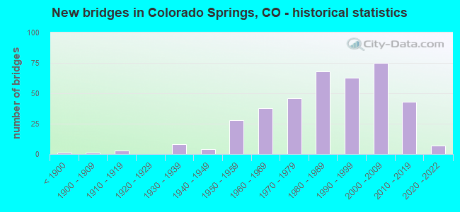
- New bridges - historical statistics
- 1Before 1900
- 11900-1909
- 31910-1919
- 81930-1939
- 41940-1949
- 281950-1959
- 381960-1969
- 461970-1979
- 681980-1989
- 631990-1999
- 752000-2009
- 432010-2019
- 72020-2022
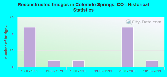
- Reconstructed bridges - Historical Statistics
- 61960-1969
- 11970-1979
- 11980-1989
- 01990-1999
- 62000-2009
- 12010-2019
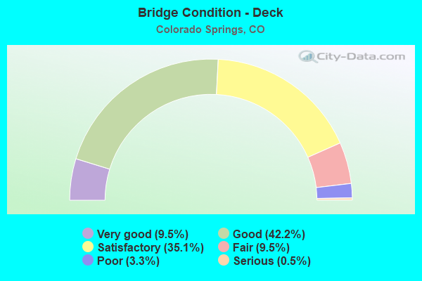
- Bridge Condition - Deck
- 9.5%Very good
- 42.2%Good
- 35.1%Satisfactory
- 9.5%Fair
- 3.3%Poor
- 0.5%Serious
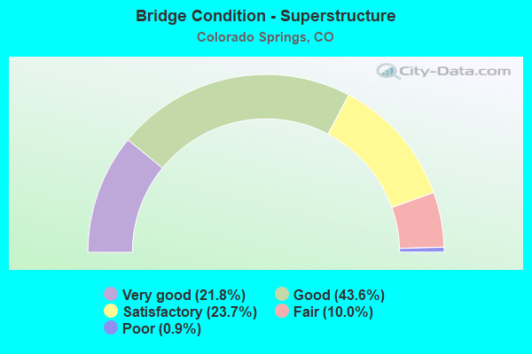
- Bridge Condition - Superstructure
- 21.8%Very good
- 43.6%Good
- 23.7%Satisfactory
- 10.0%Fair
- 0.9%Poor
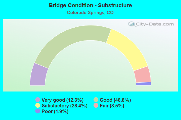
- Bridge Condition - Substructure
- 12.3%Very good
- 48.8%Good
- 28.4%Satisfactory
- 8.5%Fair
- 1.9%Poor
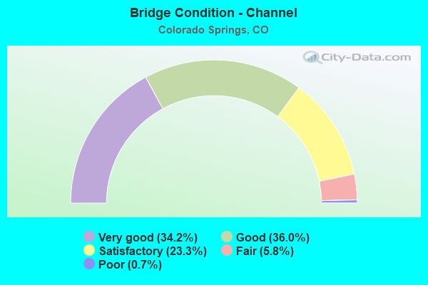
- Bridge Condition - Channel
- 34.2%Very good
- 36.0%Good
- 23.3%Satisfactory
- 5.8%Fair
- 0.7%Poor

- Bridge Condition - Culverts
- 3.5%Very good
- 18.1%Good
- 58.3%Satisfactory
- 16.7%Fair
- 3.5%Poor
Find on map >> Show street view
Structure Number: CSG-P.91-02.00A, Location: 0.8 MI W OF MARKSHEFFEL R (Lat: 38.737447, Lng: -104.666503), Route carried "on" structure: City street , Year Built: 1992, Status: Open, Structure Length: 0.85m (2.79ft), Average Daily Traffic: 6,989 (year 2020), Truck Traffic: 6%, Average Future Daily Traffic: 9,155 (year 2040), Design Load: HS 20, Features Intersected: W. TRIB JIMMY CAMP CREEK, Facility Carried by Structure: FONTAINE BLVD
Minimum Vertical Clearance: 30+ m (98+ ft), Kilometerpoint: 0.650, Lanes on structure: 2, Owner: City or Municipal Highway Agency, Approaching Roadway Width: 7.0m (23.0ft), Material/Design: Concrete, Design/Construction: Culvert, Number Of Spans In Main Unit: 1, Length of Maximum Span: 8.5m (27.9ft), Curb-To-Curb Width: 24.4m (80.1ft), Out-to-Out Width: 25.2m (82.7ft)
Condition: Channel: Very good, Culverts: Satisfactory, Operating Rating: 81.6 metric tons, Method Used To Determine Operating Rating: Load Factor (LF), Inventory Rating: 75.6 metric tons, Method Used To Determine Inventory Rating: Load Factor (LF), Structural Evaluation: Equal to present minimum criteria, Deck Geometry: Superior to present desirable criteria, Waterway Adequacy: Equal to present desirable criteria, Approach Roadway Alignment: Equal to present desirable criteria, Designated Inspection Frequency: Every 48 months, Inspection Date: July 2020
Find on map >> Show street view
Structure Number: CSG-PIKES PEAKA, Location: AT MILE POST 6.5 (Lat: 38.919908, Lng: -105.023594), Route carried "on" structure: City street , Year Built: 1994, Status: Open, Structure Length: 1.71m (5.61ft), Average Daily Traffic: 2,246 (year 2020), Truck Traffic: 2%, Average Future Daily Traffic: 2,942 (year 2040), Design Load: HS 20, Features Intersected: RESERVOIR SPILLWAY, Facility Carried by Structure: PIKES PEAK TOLL RD
Minimum Vertical Clearance: 30+ m (98+ ft), Kilometerpoint: 8.266, Lanes on structure: 2, Toll: On toll road, Owner: City or Municipal Highway Agency, Approaching Roadway Width: 7.9m (25.9ft), Skew: 9 degrees, Material/Design: Prestressed concrete, Design/Construction: Tee Beam, Number Of Spans In Main Unit: 1, Length of Maximum Span: 16.5m (54.1ft), Curb or Sidewalk Widths: Left: 0.0m, Right: 1.8m (5.9ft), Curb-To-Curb Width: 9.5m (31.2ft), Out-to-Out Width: 12.4m (40.7ft)
Condition: Deck: Satisfactory, Superstructure: Satisfactory, Substructure: Good, Channel: Very good, Operating Rating: 69.4 metric tons, Method Used To Determine Operating Rating: Load Factor (LF), Inventory Rating: 36.3 metric tons, Method Used To Determine Inventory Rating: Load Factor (LF), Structural Evaluation: Equal to present minimum criteria, Deck Geometry: Meets minimum limits, Waterway Adequacy: Equal to present desirable criteria, Approach Roadway Alignment: Equal to present desirable criteria, Designated Inspection Frequency: Every 24 months, Inspection Date: April 2020, Deck Structure Type: Concrete Cast-file-Place, Wearing Surface/Protective System: Wearing Surface: Bituminous
Find on map >> Show street view
Structure Number: CSG-R.05-03.69, Location: 0.2 MI W MARKSHEFFEL RD (Lat: 38.761992, Lng: -104.662583), Route carried "on" structure: City street , Year Built: 1985, Status: Open, Structure Length: 0.98m (3.22ft), Average Daily Traffic: 13,157 (year 2021), Truck Traffic: 2%, Average Future Daily Traffic: 17,236 (year 2041), Features Intersected: LOCAL DRAINAGE, Facility Carried by Structure: BRADLEY ROAD
Minimum Vertical Clearance: 30+ m (98+ ft), Kilometerpoint: 0.967, Lanes on structure: 5, Owner: City or Municipal Highway Agency, Approaching Roadway Width: 32.6m (107.0ft), Skew: 21 degrees, Material/Design: Concrete, Design/Construction: Culvert, Number Of Spans In Main Unit: 3, Length of Maximum Span: 3.7m (12.1ft), Curb-To-Curb Width: 33.8m (110.9ft), Out-to-Out Width: 40.0m (131.2ft)
Condition: Channel: Very good, Culverts: Satisfactory, Operating Rating: 36.3 metric tons, Method Used To Determine Operating Rating: Field evaluation and documented engineering judgment, Inventory Rating: 32.7 metric tons, Method Used To Determine Inventory Rating: Field evaluation and documented engineering judgment, Structural Evaluation: Equal to present minimum criteria, Deck Geometry: Superior to present desirable criteria, Waterway Adequacy: Better than present minimum criteria, Approach Roadway Alignment: Equal to present desirable criteria, Designated Inspection Frequency: Every 24 months, Inspection Date: May 2020
Find on map >> Show street view
Structure Number: CSG-R.40-03.69, Location: 0.1 MI W MARKSHEFFEL RD (Lat: 38.761989, Lng: -104.660883), Route carried "on" structure: City street , Year Built: 1988, Status: Open, Structure Length: 1.35m (4.43ft), Average Daily Traffic: 13,157 (year 2021), Truck Traffic: 2%, Average Future Daily Traffic: 17,236 (year 2041), Features Intersected: LOCAL DRAINAGE, Facility Carried by Structure: BRADLEY ROAD
Minimum Vertical Clearance: 30+ m (98+ ft), Kilometerpoint: 1.117, Lanes on structure: 7, Owner: City or Municipal Highway Agency, Approaching Roadway Width: 34.1m (111.9ft), Skew: 1 degrees, Material/Design: Concrete, Design/Construction: Culvert, Number Of Spans In Main Unit: 3, Length of Maximum Span: 5.0m (16.4ft), Curb-To-Curb Width: 36.1m (118.4ft), Out-to-Out Width: 39.5m (129.6ft)
Condition: Channel: Good, Culverts: Satisfactory, Operating Rating: 36.3 metric tons, Method Used To Determine Operating Rating: Field evaluation and documented engineering judgment, Inventory Rating: 32.7 metric tons, Method Used To Determine Inventory Rating: Field evaluation and documented engineering judgment, Structural Evaluation: Equal to present minimum criteria, Deck Geometry: Superior to present desirable criteria, Waterway Adequacy: Equal to present desirable criteria, Approach Roadway Alignment: Equal to present desirable criteria, Designated Inspection Frequency: Every 24 months, Inspection Date: May 2020
Find on map >> Show street view
Structure Number: CSG-R.50-03.69, Location: .33 MI E MARKSHEFFEL RD (Lat: 38.762128, Lng: -104.652861), Route carried "on" structure: City street , Year Built: 1999, Status: Open, Structure Length: 11.59m (38.02ft), Average Daily Traffic: 2,812 (year 2021), Truck Traffic: 2%, Average Future Daily Traffic: 3,684 (year 2041), Design Load: HS 25 or greater, Features Intersected: JIMMY CAMP CREEK, Facility Carried by Structure: BRADLEY ROAD
Minimum Vertical Clearance: 30+ m (98+ ft), Kilometerpoint: 1.830, Lanes on structure: 2, Owner: City or Municipal Highway Agency, Approaching Roadway Width: 12.5m (41.0ft), Skew: 2 degrees, Material/Design: Prestressed concrete continuous, Design/Construction: Stringer/Multi-beam, Number Of Spans In Main Unit: 3, Length of Maximum Span: 37.9m (124.3ft), Curb or Sidewalk Widths: Left: 1.8m (5.9ft), Right: 0.0m, Curb-To-Curb Width: 18.3m (60.0ft), Out-to-Out Width: 21.0m (68.9ft)
Condition: Deck: Good, Superstructure: Good, Substructure: Good, Channel: Good, Operating Rating: 96.2 metric tons, Method Used To Determine Operating Rating: Load Factor (LF), Inventory Rating: 56.3 metric tons, Method Used To Determine Inventory Rating: Load Factor (LF), Structural Evaluation: Better than present minimum criteria, Deck Geometry: Superior to present desirable criteria, Waterway Adequacy: Equal to present desirable criteria, Approach Roadway Alignment: Equal to present desirable criteria, Designated Inspection Frequency: Every 24 months, Inspection Date: May 2020, Deck Structure Type: Concrete Precast Panels, Wearing Surface/Protective System: Wearing Surface: Bituminous, Membrane: Built-up, Deck Protection: Epoxy Coated Reinforcing
Find on map >> Show street view
Structure Number: CSG-R.55-02.84, Location: 1 MI S of BRADLEY RD (Lat: 38.750000, Lng: -104.652444), Route carried "on" structure: City street , Year Built: 2017, Status: Open, Structure Length: 0.84m (2.76ft), Average Daily Traffic: 2,226 (year 2021), Average Future Daily Traffic: 2,916 (year 2041), Features Intersected: LOCAL DRAINAGE, Facility Carried by Structure: MARKSHEFFEL RD
Minimum Vertical Clearance: 30+ m (98+ ft), Kilometerpoint: 0.639, Lanes on structure: 2, Owner: City or Municipal Highway Agency, Approaching Roadway Width: 20.4m (66.9ft), Skew: 1 degrees, Material/Design: Concrete, Design/Construction: Culvert, Number Of Spans In Main Unit: 1, Length of Maximum Span: 3.8m (12.5ft), Out-to-Out Width: 50.6m (166.0ft)
Condition: Channel: Good, Culverts: Very good, Operating Rating: 36.3 metric tons, Method Used To Determine Operating Rating: Field evaluation and documented engineering judgment, Inventory Rating: 32.7 metric tons, Method Used To Determine Inventory Rating: Field evaluation and documented engineering judgment, Structural Evaluation: Equal to present desirable criteria, Waterway Adequacy: Equal to present desirable criteria, Approach Roadway Alignment: Equal to present desirable criteria, Designated Inspection Frequency: Every 24 months, Inspection Date: April 2020
Find on map >> Show street view
Structure Number: CSG-R.73-05., Location: 0.5 MI E MARKSHEFFEL RD (Lat: 38.781006, Lng: -104.650664), Route carried "on" structure: City street , Year Built: 1964, Status: Posted for load, Structure Length: 1.84m (6.04ft), Average Daily Traffic: 2,210 (year 2021), Truck Traffic: 2%, Average Future Daily Traffic: 2,895 (year 2041), Features Intersected: JIMMY CAMP CREEK, Facility Carried by Structure: DRENNAN ROAD
Minimum Vertical Clearance: 30+ m (98+ ft), Kilometerpoint: 2.766, Lanes on structure: 2, Owner: City or Municipal Highway Agency, Approaching Roadway Width: 7.6m (24.9ft), Material/Design: Prestressed concrete, Design/Construction: Tee Beam, Number Of Spans In Main Unit: 2, Length of Maximum Span: 8.5m (27.9ft), Curb-To-Curb Width: 8.8m (28.9ft), Out-to-Out Width: 9.1m (29.9ft)
Condition: Deck: Fair, Superstructure: Fair, Substructure: Fair, Channel: Good, Operating Rating: 18.1 metric tons, Method Used To Determine Operating Rating: Load Factor (LF), Inventory Rating: 15.5 metric tons, Method Used To Determine Inventory Rating: Load Factor (LF), Structural Evaluation: Meets minimum limits, Deck Geometry: Meets minimum limits, Waterway Adequacy: Equal to present desirable criteria, Approach Roadway Alignment: Equal to present desirable criteria, Bridge Posting: Required (Relationship of Operating Rating to Maximum Legal Load: > 39.9% below), Designated Inspection Frequency: Every 24 months, Inspection Date: May 2020, Deck Structure Type: Other, Wearing Surface/Protective System: Wearing Surface: Bituminous
Find on map >> Show street view
Structure Number: CSG-S.37-05., Location: 0.8 MI E OF MARKSHEFFEL R (Lat: 38.781036, Lng: -104.638514), Route carried "on" structure: City street , Year Built: 1984, Status: Open, Structure Length: 4.99m (16.37ft), Average Daily Traffic: 2,210 (year 2021), Truck Traffic: 2%, Average Future Daily Traffic: 2,895 (year 2041), Design Load: HS 20, Features Intersected: JIMMY CAMP CREEK TRIB., Facility Carried by Structure: DRENNAN RD
Minimum Vertical Clearance: 30+ m (98+ ft), Kilometerpoint: 3.798, Lanes on structure: 2, Owner: City or Municipal Highway Agency, Approaching Roadway Width: 7.3m (24.0ft), Material/Design: Prestressed concrete, Design/Construction: Stringer/Multi-beam, Number Of Spans In Main Unit: 2, Length of Maximum Span: 23.5m (77.1ft), Curb-To-Curb Width: 11.0m (36.1ft), Out-to-Out Width: 11.7m (38.4ft)
Condition: Deck: Good, Superstructure: Very good, Substructure: Satisfactory, Channel: Satisfactory, Operating Rating: 62.9 metric tons, Method Used To Determine Operating Rating: Load Factor (LF), Inventory Rating: 34.0 metric tons, Method Used To Determine Inventory Rating: Load Factor (LF), Structural Evaluation: Equal to present minimum criteria, Deck Geometry: Somewhat better than minimum adequacy, Waterway Adequacy: Equal to present desirable criteria, Approach Roadway Alignment: Equal to present desirable criteria, Designated Inspection Frequency: Every 48 months, Inspection Date: July 2020, Deck Structure Type: Concrete Cast-file-Place, Wearing Surface/Protective System: Wearing Surface: Bituminous
Find on map >> Show street view
Structure Number: EPC0055-15.45, Location: 0.4 MI. W. of FALCON (Lat: 38.940567, Lng: -104.620136), Route carried "on" structure: Interstate , Year Built: 2011, Status: Open, Structure Length: 0.68m (2.23ft), Average Daily Traffic: 12,805 (year 2021), Average Future Daily Traffic: 16,775 (year 2041), Features Intersected: BLK SQUIRREL CRK TRIB, Facility Carried by Structure: WOODMEN RD
Minimum Vertical Clearance: 30+ m (98+ ft), Kilometerpoint: 0.000, Lanes on structure: 5, Owner: County Highway Agency, Approaching Roadway Width: 30.2m (99.1ft), Skew: 3 degrees, Material/Design: Concrete, Design/Construction: Culvert, Number Of Spans In Main Unit: 1, Length of Maximum Span: 6.8m (22.3ft), Out-to-Out Width: 65.8m (215.9ft)
Condition: Channel: Very good, Culverts: Satisfactory, Operating Rating: 36.3 metric tons, Method Used To Determine Operating Rating: Field evaluation and documented engineering judgment, Inventory Rating: 32.7 metric tons, Method Used To Determine Inventory Rating: Field evaluation and documented engineering judgment, Structural Evaluation: Equal to present minimum criteria, Waterway Adequacy: Equal to present desirable criteria, Approach Roadway Alignment: Equal to present desirable criteria, Designated Inspection Frequency: Every 24 months, Inspection Date: March 2020
Find on map >> Show street view
Structure Number: EPC0108-00.63, Location: 0.36 MI. W. OF US24 (Lat: 38.955000, Lng: -104.585000), Route carried "on" structure: County highway , Year Built: 2019, Status: Open, Structure Length: 0.80m (2.62ft), Average Daily Traffic: 3,001 (year 2021), Average Future Daily Traffic: 3,931 (year 2041), Features Intersected: BLK SQUIRREL CRK TRIB, Facility Carried by Structure: JUDGE ORR RD
Minimum Vertical Clearance: 30+ m (98+ ft), Kilometerpoint: 0.502, Lanes on structure: 2, Owner: County Highway Agency, Approaching Roadway Width: 7.6m (24.9ft), Material/Design: Concrete, Design/Construction: Culvert, Number Of Spans In Main Unit: 2, Length of Maximum Span: 3.7m (12.1ft), Out-to-Out Width: 24.7m (81.0ft)
Condition: Channel: Very good, Culverts: Very good, Operating Rating: 36.3 metric tons, Method Used To Determine Operating Rating: Field evaluation and documented engineering judgment, Inventory Rating: 32.7 metric tons, Method Used To Determine Inventory Rating: Field evaluation and documented engineering judgment, Structural Evaluation: Equal to present desirable criteria, Waterway Adequacy: Equal to present desirable criteria, Approach Roadway Alignment: Equal to present desirable criteria, Designated Inspection Frequency: Every 24 months, Inspection Date: Febuary 2022
Find on map >> Show street view
Structure Number: EPC0132-01.90A, Location: 0.1 MI E OF ABILENE DRIVE (Lat: 38.925556, Lng: -104.583056), Route carried "on" structure: County highway , Year Built: 1995, Status: Open, Structure Length: 1.88m (6.17ft), Average Daily Traffic: 2,048 (year 2021), Truck Traffic: 4%, Average Future Daily Traffic: 2,683 (year 2041), Design Load: HS 20, Features Intersected: BRANCH SQUIRREL CREEK, Facility Carried by Structure: FALCON HIGHWAY
Minimum Vertical Clearance: 30+ m (98+ ft), Kilometerpoint: 2.131, Lanes on structure: 2, Owner: County Highway Agency, Approaching Roadway Width: 7.3m (24.0ft), Material/Design: Concrete, Design/Construction: Culvert, Number Of Spans In Main Unit: 3, Length of Maximum Span: 6.1m (20.0ft), Curb-To-Curb Width: 11.0m (36.1ft), Out-to-Out Width: 11.8m (38.7ft)
Condition: Channel: Good, Culverts: Good, Inventory Rating: 73.3 metric tons, Method Used To Determine Inventory Rating: Load Factor (LF), Structural Evaluation: Better than present minimum criteria, Deck Geometry: Somewhat better than minimum adequacy, Waterway Adequacy: Equal to present desirable criteria, Approach Roadway Alignment: Equal to present desirable criteria, Designated Inspection Frequency: Every 24 months, Inspection Date: Febuary 2020, Deck Structure Type: Concrete Cast-file-Place, Wearing Surface/Protective System: Wearing Surface: Bituminous, Membrane: Built-up
Find on map >> Show street view
Structure Number: EPC0132-03.50A, Location: 0.1 MI W OF CURTIS ROAD (Lat: 38.925278, Lng: -104.556111), Route carried "on" structure: County highway , Year Built: 1991, Status: Open, Structure Length: 0.80m (2.62ft), Average Daily Traffic: 2,020 (year 2021), Truck Traffic: 4%, Average Future Daily Traffic: 2,646 (year 2041), Design Load: HS 20, Features Intersected: WEST FORK SQUIRREL CREEK, Facility Carried by Structure: FALCON HIGHWAY
Minimum Vertical Clearance: 30+ m (98+ ft), Kilometerpoint: 4.464, Lanes on structure: 2, Owner: County Highway Agency, Approaching Roadway Width: 7.6m (24.9ft), Material/Design: Steel, Design/Construction: Stringer/Multi-beam, Number Of Spans In Main Unit: 1, Length of Maximum Span: 6.9m (22.6ft), Curb-To-Curb Width: 12.1m (39.7ft), Out-to-Out Width: 12.3m (40.4ft)
Condition: Deck: Satisfactory, Superstructure: Satisfactory, Substructure: Good, Channel: Good, Operating Rating: 58.9 metric tons, Method Used To Determine Operating Rating: Load Factor (LF), Inventory Rating: 35.3 metric tons, Method Used To Determine Inventory Rating: Load Factor (LF), Structural Evaluation: Equal to present minimum criteria, Deck Geometry: Somewhat better than minimum adequacy, Waterway Adequacy: Equal to present desirable criteria, Approach Roadway Alignment: Equal to present desirable criteria, Designated Inspection Frequency: Every 24 months, Inspection Date: March 2020, Deck Structure Type: Corrugated Steel, Wearing Surface/Protective System: Wearing Surface: Bituminous
Find on map >> Show street view
Structure Number: EPC0160-01.70A, Location: JUST E OF CONDOR ROAD (Lat: 38.911389, Lng: -104.596389), Route carried "on" structure: County highway , Year Built: 1983, Status: Open, Structure Length: 1.45m (4.76ft), Average Daily Traffic: 901 (year 2021), Truck Traffic: 4%, Average Future Daily Traffic: 1,181 (year 2041), Design Load: HS 20, Features Intersected: WEST FORK SQUIRREL CREEK, Facility Carried by Structure: GARRETT ROAD
Minimum Vertical Clearance: 30+ m (98+ ft), Kilometerpoint: 2.634, Lanes on structure: 2, Owner: County Highway Agency, Approaching Roadway Width: 7.0m (23.0ft), Material/Design: Steel, Design/Construction: Culvert, Number Of Spans In Main Unit: 3, Length of Maximum Span: 3.6m (11.8ft), Out-to-Out Width: 17.9m (58.7ft)
Condition: Channel: Good, Culverts: Satisfactory, Structural Evaluation: Equal to present minimum criteria, Waterway Adequacy: Equal to present desirable criteria, Approach Roadway Alignment: Equal to present desirable criteria, Designated Inspection Frequency: Every 24 months, Inspection Date: Febuary 2020
Find on map >> Show street view
Structure Number: EPC0285-07.5, Location: 2 MI E OF MARKSHEFFEL RD (Lat: 38.765278, Lng: -104.622500), Route carried "on" structure: County highway , Year Built: 1999, Status: Open, Structure Length: 0.99m (3.25ft), Average Daily Traffic: 173 (year 2021), Truck Traffic: 2%, Average Future Daily Traffic: 226 (year 2041), Design Load: HS 20, Features Intersected: E JIMMY CAMP CREEK TRIB, Facility Carried by Structure: BRADLEY ROAD
Minimum Vertical Clearance: 30+ m (98+ ft), Kilometerpoint: 1.268, Lanes on structure: 2, Owner: County Highway Agency, Approaching Roadway Width: 12.6m (41.3ft), Skew: 4 degrees, Material/Design: Concrete, Design/Construction: Culvert, Number Of Spans In Main Unit: 2, Length of Maximum Span: 4.8m (15.7ft), Out-to-Out Width: 32.2m (105.6ft)
Condition: Channel: Good, Culverts: Satisfactory, Operating Rating: 81.6 metric tons, Method Used To Determine Operating Rating: Load Factor (LF), Inventory Rating: 62.1 metric tons, Method Used To Determine Inventory Rating: Load Factor (LF), Structural Evaluation: Equal to present minimum criteria, Waterway Adequacy: Equal to present desirable criteria, Approach Roadway Alignment: Equal to present desirable criteria, Designated Inspection Frequency: Every 24 months, Inspection Date: March 2020
Find on map >> Show street view
Structure Number: EPC0377-00.50A, Location: 0.4 MI N OF CIRCLE DR (Lat: 38.802331, Lng: -104.794378), Route carried "on" structure: County highway , Year Built: 1990, Status: Open, Structure Length: 13.82m (45.34ft), Average Daily Traffic: 4,575 (year 2021), Truck Traffic: 10%, Average Future Daily Traffic: 5,993 (year 2041), Design Load: HS 20, Features Intersected: FOUNTAIN CREEK, Facility Carried by Structure: JANITELL ROAD
Minimum Vertical Clearance: 30+ m (98+ ft), Kilometerpoint: 0.523, Lanes on structure: 2, Owner: County Highway Agency, Approaching Roadway Width: 12.2m (40.0ft), Skew: 3 degrees, Material/Design: Prestressed concrete continuous, Design/Construction: Stringer/Multi-beam, Number Of Spans In Main Unit: 5, Length of Maximum Span: 27.0m (88.6ft), Curb-To-Curb Width: 12.3m (40.4ft), Out-to-Out Width: 13.1m (43.0ft)
Condition: Deck: Good, Superstructure: Very good, Substructure: Good, Channel: Satisfactory, Operating Rating: 45.4 metric tons, Method Used To Determine Operating Rating: Load Factor (LF), Inventory Rating: 27.2 metric tons, Method Used To Determine Inventory Rating: Load Factor (LF), Structural Evaluation: Equal to present minimum criteria, Deck Geometry: Equal to present minimum criteria, Waterway Adequacy: Equal to present desirable criteria, Approach Roadway Alignment: Equal to present minimum criteria, Designated Inspection Frequency: Every 24 months, Inspection Date: March 2020, Deck Structure Type: Concrete Cast-file-Place, Wearing Surface/Protective System: Wearing Surface: Bituminous, Membrane: Built-up
Find on map >> Show street view
Structure Number: EPC0379-00.71A, Location: 0.71 MI N OF HWY 85-87 (Lat: 38.787222, Lng: -104.776111), Route carried "on" structure: County highway , Year Built: 1995, Status: Open, Structure Length: 8.11m (26.61ft), Average Daily Traffic: 5,572 (year 2021), Truck Traffic: 4%, Average Future Daily Traffic: 7,299 (year 2041), Design Load: HS 20, Features Intersected: SAND CREEK, Facility Carried by Structure: LAS VEGAS ST
Minimum Vertical Clearance: 30+ m (98+ ft), Kilometerpoint: 0.392, Lanes on structure: 2, Owner: County Highway Agency, Approaching Roadway Width: 7.3m (24.0ft), Skew: 1 degrees, Material/Design: Prestressed concrete continuous, Design/Construction: Stringer/Multi-beam, Number Of Spans In Main Unit: 2, Length of Maximum Span: 39.0m (128.0ft), Curb or Sidewalk Widths: Left: 3.3m (10.8ft), Right: 0.0m, Curb-To-Curb Width: 15.8m (51.8ft), Out-to-Out Width: 16.8m (55.1ft)
Condition: Deck: Good, Superstructure: Very good, Substructure: Very good, Channel: Good, Operating Rating: 58.7 metric tons, Method Used To Determine Operating Rating: Load Factor (LF), Inventory Rating: 35.2 metric tons, Method Used To Determine Inventory Rating: Load Factor (LF), Structural Evaluation: Equal to present desirable criteria, Deck Geometry: Superior to present desirable criteria, Waterway Adequacy: Equal to present desirable criteria, Approach Roadway Alignment: Equal to present desirable criteria, Designated Inspection Frequency: Every 24 months, Inspection Date: March 2020, Deck Structure Type: Concrete Cast-file-Place, Wearing Surface/Protective System: Wearing Surface: Bituminous, Membrane: Built-up
Find on map >> Show street view
Structure Number: EPC0379-02.46, Location: 2.46 MI N OF HWY 85-87 (Lat: 38.807500, Lng: -104.795278), Route carried "on" structure: County highway , Year Built: 1981, Year Reconstructed: 2005, Status: Open, Structure Length: 1.43m (4.69ft), Average Daily Traffic: 1,574 (year 2021), Truck Traffic: 4%, Average Future Daily Traffic: 2,062 (year 2041), Features Intersected: SPRING CREEK, Facility Carried by Structure: LAS VEGAS ST
Minimum Vertical Clearance: 30+ m (98+ ft), Kilometerpoint: 1.655, Lanes on structure: 2, Owner: County Highway Agency, Approaching Roadway Width: 7.3m (24.0ft), Skew: 4 degrees, Material/Design: Steel, Design/Construction: Stringer/Multi-beam, Number Of Spans In Main Unit: 1, Length of Maximum Span: 13.2m (43.3ft), Curb-To-Curb Width: 11.9m (39.0ft), Out-to-Out Width: 12.2m (40.0ft)
Condition: Deck: Satisfactory, Superstructure: Good, Substructure: Fair, Channel: Satisfactory, Operating Rating: 46.5 metric tons, Method Used To Determine Operating Rating: Load Factor (LF), Inventory Rating: 26.5 metric tons, Method Used To Determine Inventory Rating: Load Factor (LF), Structural Evaluation: Somewhat better than minimum adequacy, Deck Geometry: Equal to present minimum criteria, Waterway Adequacy: Equal to present desirable criteria, Approach Roadway Alignment: Better than present minimum criteria, Designated Inspection Frequency: Every 24 months, Inspection Date: March 2020, Deck Structure Type: Corrugated Steel, Wearing Surface/Protective System: Wearing Surface: Bituminous
Find on map >> Show street view
Structure Number: EPC0429-01.84, Location: 0.5 MI N OF JUDGE ORR RD (Lat: 38.962419, Lng: -104.585806), Route carried "on" structure: County highway , Year Built: 2004, Status: Open, Structure Length: 1.01m (3.31ft), Average Daily Traffic: 2,255 (year 2020), Truck Traffic: 8%, Average Future Daily Traffic: 2,954 (year 2040), Design Load: HS 25 or greater, Features Intersected: SQUIRREL CREEK TRIBUTARY, Facility Carried by Structure: EASTONVILLE ROAD
Minimum Vertical Clearance: 30+ m (98+ ft), Kilometerpoint: 3.095, Lanes on structure: 2, Owner: County Highway Agency, Approaching Roadway Width: 13.4m (44.0ft), Skew: 4 degrees, Material/Design: Concrete, Design/Construction: Culvert, Number Of Spans In Main Unit: 2, Length of Maximum Span: 4.7m (15.4ft), Out-to-Out Width: 31.0m (101.7ft)
Condition: Channel: Satisfactory, Culverts: Satisfactory, Operating Rating: 36.3 metric tons, Method Used To Determine Operating Rating: Field evaluation and documented engineering judgment, Inventory Rating: 32.7 metric tons, Method Used To Determine Inventory Rating: Field evaluation and documented engineering judgment, Structural Evaluation: Equal to present minimum criteria, Waterway Adequacy: Equal to present desirable criteria, Approach Roadway Alignment: Equal to present desirable criteria, Designated Inspection Frequency: Every 24 months, Inspection Date: Febuary 2022
Find on map >> Show street view
Structure Number: EPC0437-02.14, Location: .86 MI S OF HWY 94 (Lat: 38.826389, Lng: -104.590833), Route carried "on" structure: County highway , Year Built: 1965, Status: Open, Structure Length: 1.19m (3.90ft), Average Daily Traffic: 32 (year 2021), Truck Traffic: 2%, Average Future Daily Traffic: 41 (year 2041), Features Intersected: JIMMY CAMP CREEK, Facility Carried by Structure: FRANCEVL COALMN RD
Minimum Vertical Clearance: 30+ m (98+ ft), Kilometerpoint: 3.124, Lanes on structure: 2, Owner: County Highway Agency, Approaching Roadway Width: 7.3m (24.0ft), Material/Design: Prestressed concrete, Design/Construction: Tee Beam, Number Of Spans In Main Unit: 1, Length of Maximum Span: 11.1m (36.4ft), Curb-To-Curb Width: 9.0m (29.5ft), Out-to-Out Width: 9.1m (29.9ft)
Condition: Deck: Good, Superstructure: Good, Substructure: Fair, Channel: Very good, Operating Rating: 33.0 metric tons, Method Used To Determine Operating Rating: Load Factor (LF), Inventory Rating: 30.3 metric tons, Method Used To Determine Inventory Rating: Load Factor (LF), Structural Evaluation: Somewhat better than minimum adequacy, Deck Geometry: Better than present minimum criteria, Waterway Adequacy: Equal to present desirable criteria, Approach Roadway Alignment: Equal to present desirable criteria, Designated Inspection Frequency: Every 24 months, Inspection Date: March 2020, Deck Structure Type: Other, Wearing Surface/Protective System: Wearing Surface: Bituminous
Find on map >> Show street view
Structure Number: EPC0439-08.90A, Location: 3.0 MILES N OF HWY 94 (Lat: 38.880556, Lng: -104.553611), Route carried "on" structure: County highway , Year Built: 1997, Status: Open, Structure Length: 2.50m (8.20ft), Average Daily Traffic: 379 (year 2021), Truck Traffic: 4%, Average Future Daily Traffic: 497 (year 2041), Design Load: HS 20, Features Intersected: BLACK SQUIRREL CREEK, Facility Carried by Structure: CURTIS ROAD
Minimum Vertical Clearance: 30+ m (98+ ft), Kilometerpoint: 14.628, Lanes on structure: 2, Owner: County Highway Agency, Approaching Roadway Width: 7.6m (24.9ft), Material/Design: Steel continuous, Design/Construction: Stringer/Multi-beam, Number Of Spans In Main Unit: 2, Length of Maximum Span: 12.1m (39.7ft), Curb-To-Curb Width: 10.8m (35.4ft), Out-to-Out Width: 11.0m (36.1ft)
Condition: Deck: Fair, Superstructure: Fair, Substructure: Satisfactory, Channel: Very good, Operating Rating: 66.3 metric tons, Method Used To Determine Operating Rating: Load Factor (LF), Inventory Rating: 39.7 metric tons, Method Used To Determine Inventory Rating: Load Factor (LF), Structural Evaluation: Somewhat better than minimum adequacy, Deck Geometry: Better than present minimum criteria, Waterway Adequacy: Equal to present desirable criteria, Approach Roadway Alignment: Equal to present desirable criteria, Designated Inspection Frequency: Every 24 months, Inspection Date: March 2020, Deck Structure Type: Corrugated Steel, Wearing Surface/Protective System: Wearing Surface: Bituminous
Find on map >> Show street view
Structure Number: EPC0458-08.55, Location: 1.6 MI E MARKSHEFFEL RD (Lat: 38.781111, Lng: -104.611389), Route carried "on" structure: County highway , Year Built: 1970, Status: Open, Structure Length: 1.86m (6.10ft), Average Daily Traffic: 170 (year 2021), Truck Traffic: 4%, Average Future Daily Traffic: 222 (year 2041), Design Load: HS 20, Features Intersected: E. JIMMY CAMP CREEK TRIB, Facility Carried by Structure: DRENNAN ROAD
Minimum Vertical Clearance: 30+ m (98+ ft), Kilometerpoint: 0.565, Lanes on structure: 2, Owner: County Highway Agency, Approaching Roadway Width: 7.3m (24.0ft), Material/Design: Prestressed concrete, Design/Construction: Tee Beam, Number Of Spans In Main Unit: 2, Length of Maximum Span: 8.7m (28.5ft), Curb-To-Curb Width: 9.0m (29.5ft), Out-to-Out Width: 9.2m (30.2ft)
Condition: Deck: Satisfactory, Superstructure: Satisfactory, Substructure: Satisfactory, Channel: Good, Operating Rating: 43.9 metric tons, Method Used To Determine Operating Rating: Load Factor (LF), Inventory Rating: 32.7 metric tons, Method Used To Determine Inventory Rating: Load Factor (LF), Structural Evaluation: Equal to present minimum criteria, Deck Geometry: Equal to present minimum criteria, Waterway Adequacy: Equal to present desirable criteria, Approach Roadway Alignment: Equal to present desirable criteria, Designated Inspection Frequency: Every 24 months, Inspection Date: March 2020, Deck Structure Type: Other, Wearing Surface/Protective System: Wearing Surface: Bituminous
Find on map >> Show street view
Structure Number: EPC0867-00.75A, Location: 0.25 MI S OF OLD RANCH RD (Lat: 38.978333, Lng: -104.790278), Route carried "on" structure: County highway , Year Built: 1997, Status: Open, Structure Length: 3.66m (12.01ft), Average Daily Traffic: 730 (year 2021), Average Future Daily Traffic: 956 (year 2041), Design Load: HS 20, Features Intersected: KETTLE CREEK, Facility Carried by Structure: OTERO AVENUE
Minimum Vertical Clearance: 30+ m (98+ ft), Kilometerpoint: 1.215, Lanes on structure: 2, Owner: County Highway Agency, Approaching Roadway Width: 7.9m (25.9ft), Material/Design: Steel continuous, Design/Construction: Stringer/Multi-beam, Number Of Spans In Main Unit: 4, Length of Maximum Span: 9.0m (29.5ft), Curb-To-Curb Width: 9.2m (30.2ft), Out-to-Out Width: 9.2m (30.2ft)
Condition: Deck: Satisfactory, Superstructure: Good, Substructure: Very good, Channel: Satisfactory, Operating Rating: 67.8 metric tons, Method Used To Determine Operating Rating: Load Factor (LF), Inventory Rating: 40.6 metric tons, Method Used To Determine Inventory Rating: Load Factor (LF), Structural Evaluation: Better than present minimum criteria, Deck Geometry: Equal to present minimum criteria, Waterway Adequacy: Equal to present desirable criteria, Approach Roadway Alignment: Equal to present desirable criteria, Designated Inspection Frequency: Every 24 months, Inspection Date: March 2020, Deck Structure Type: Corrugated Steel, Wearing Surface/Protective System: Wearing Surface: Bituminous
Find on map >> Show street view
Structure Number: EPC1152-00.79, Location: 0.5 MI SW OF JUDGE ORA (Lat: 38.948611, Lng: -104.582500), Route carried "on" structure: County highway , Year Built: 2012, Status: Open, Structure Length: 0.80m (2.62ft), Average Daily Traffic: 279 (year 2021), Average Future Daily Traffic: 366 (year 2041), Design Load: HS 20, Features Intersected: UNKNOWN DRAINAGE, Facility Carried by Structure: BLUE GILL DR
Minimum Vertical Clearance: 30.17m (98.98ft), Kilometerpoint: 1.389, Lanes on structure: 2, Owner: County Highway Agency, Approaching Roadway Width: 9.1m (29.9ft), Material/Design: Concrete, Design/Construction: Culvert, Number Of Spans In Main Unit: 2, Length of Maximum Span: 3.7m (12.1ft), Out-to-Out Width: 21.9m (71.9ft)
Condition: Channel: Satisfactory, Culverts: Good, Operating Rating: 36.3 metric tons, Method Used To Determine Operating Rating: Field evaluation and documented engineering judgment, Inventory Rating: 32.7 metric tons, Method Used To Determine Inventory Rating: Field evaluation and documented engineering judgment, Structural Evaluation: Better than present minimum criteria, Waterway Adequacy: Better than present minimum criteria, Approach Roadway Alignment: Equal to present minimum criteria, Designated Inspection Frequency: Every 24 months, Inspection Date: Febuary 2022
Find on map >> Show street view
Structure Number: EPC1272-06.90A, Location: .25 MI W MARKSHEFFEL RD (Lat: 38.867789, Lng: -104.687253), Route carried "on" structure: County highway , Year Built: 1985, Status: Open, Structure Length: 0.95m (3.12ft), Average Daily Traffic: 8,646 (year 2021), Truck Traffic: 4%, Average Future Daily Traffic: 11,326 (year 2041), Features Intersected: EAST FORK SAND CREEK, Facility Carried by Structure: CONSTITUTION AVE
Minimum Vertical Clearance: 30+ m (98+ ft), Kilometerpoint: 2.417, Lanes on structure: 7, Base Highway Network: Yes, Owner: County Highway Agency, Approaching Roadway Width: 26.8m (87.9ft), Skew: 23 degrees, Material/Design: Concrete, Design/Construction: Culvert, Number Of Spans In Main Unit: 2, Length of Maximum Span: 4.6m (15.1ft), Curb-To-Curb Width: 31.7m (104.0ft), Out-to-Out Width: 67.0m (219.8ft)
Condition: Channel: Very good, Culverts: Fair, Operating Rating: 36.3 metric tons, Method Used To Determine Operating Rating: Field evaluation and documented engineering judgment, Inventory Rating: 32.7 metric tons, Method Used To Determine Inventory Rating: Field evaluation and documented engineering judgment, Structural Evaluation: Somewhat better than minimum adequacy, Deck Geometry: Superior to present desirable criteria, Waterway Adequacy: Equal to present desirable criteria, Approach Roadway Alignment: Equal to present desirable criteria, Designated Inspection Frequency: Every 24 months, Inspection Date: Febuary 2020
Find on map >> Show street view
Structure Number: EPC1272-07.40A, Location: .4 MI E MARKSHEFFEL RD (Lat: 38.868333, Lng: -104.678056), Route carried "on" structure: County highway , Year Built: 1985, Status: Open, Structure Length: 1.59m (5.22ft), Average Daily Traffic: 4,402 (year 2021), Truck Traffic: 4%, Average Future Daily Traffic: 5,766 (year 2041), Features Intersected: EAST FORK SAND CREEK, Facility Carried by Structure: CONSTITUTION AVE
Minimum Vertical Clearance: 30+ m (98+ ft), Kilometerpoint: 0.428, Lanes on structure: 5, Owner: City or Municipal Highway Agency, Approaching Roadway Width: 23.5m (77.1ft), Skew: 20 degrees, Material/Design: Concrete, Design/Construction: Culvert, Number Of Spans In Main Unit: 4, Length of Maximum Span: 4.3m (14.1ft), Curb or Sidewalk Widths: Left: 1.8m (5.9ft), Right: 1.9m (6.2ft), Curb-To-Curb Width: 28.3m (92.8ft), Out-to-Out Width: 35.4m (116.1ft)
Condition: Channel: Very good, Culverts: Satisfactory, Operating Rating: 36.3 metric tons, Method Used To Determine Operating Rating: Field evaluation and documented engineering judgment, Inventory Rating: 32.7 metric tons, Method Used To Determine Inventory Rating: Field evaluation and documented engineering judgment, Structural Evaluation: Equal to present minimum criteria, Deck Geometry: Superior to present desirable criteria, Waterway Adequacy: Equal to present desirable criteria, Approach Roadway Alignment: Equal to present desirable criteria, Designated Inspection Frequency: Every 48 months, Inspection Date: Febuary 2020
Find on map >> Show street view
Structure Number: EPC1272-07.60A, Location: .6 MI E MARKSHEFFEL RD (Lat: 38.868333, Lng: -104.673889), Route carried "on" structure: County highway , Year Built: 1985, Status: Open, Structure Length: 4.51m (14.80ft), Average Daily Traffic: 4,740 (year 2021), Truck Traffic: 4%, Average Future Daily Traffic: 6,209 (year 2041), Design Load: HS 20, Features Intersected: EAST FORK SAND CREEK, Facility Carried by Structure: CONSTITUTION AVE
Minimum Vertical Clearance: 30+ m (98+ ft), Kilometerpoint: 0.801, Lanes on structure: 5, Owner: City or Municipal Highway Agency, Approaching Roadway Width: 23.5m (77.1ft), Skew: 23 degrees, Material/Design: Concrete, Design/Construction: Culvert, Number Of Spans In Main Unit: 9, Length of Maximum Span: 5.3m (17.4ft), Curb or Sidewalk Widths: Left: 1.8m (5.9ft), Right: 1.8m (5.9ft), Curb-To-Curb Width: 32.0m (105.0ft), Out-to-Out Width: 32.9m (107.9ft)
Condition: Channel: Very good, Culverts: Satisfactory, Operating Rating: 36.3 metric tons, Method Used To Determine Operating Rating: Field evaluation and documented engineering judgment, Inventory Rating: 32.7 metric tons, Method Used To Determine Inventory Rating: Field evaluation and documented engineering judgment, Structural Evaluation: Equal to present minimum criteria, Deck Geometry: Superior to present desirable criteria, Waterway Adequacy: Equal to present desirable criteria, Approach Roadway Alignment: Equal to present desirable criteria, Designated Inspection Frequency: Every 48 months, Inspection Date: Febuary 2020
Find on map >> Show street view
Structure Number: EPC1386-00.75A, Location: 0.1 MI E OF OTERO AVENUE (Lat: 38.981111, Lng: -104.785000), Route carried "on" structure: County highway , Year Built: 1988, Status: Open, Structure Length: 4.23m (13.88ft), Average Daily Traffic: 8,618 (year 2021), Truck Traffic: 9%, Average Future Daily Traffic: 11,290 (year 2041), Design Load: HS 20, Features Intersected: KETTLE CREEK, Facility Carried by Structure: OLD RANCH ROAD
Minimum Vertical Clearance: 30+ m (98+ ft), Kilometerpoint: 0.512, Lanes on structure: 2, Owner: County Highway Agency, Approaching Roadway Width: 17.4m (57.1ft), Skew: 5 degrees, Material/Design: Prestressed concrete, Design/Construction: Stringer/Multi-beam, Number Of Spans In Main Unit: 1, Number Of Approach Spans: 2, Length of Maximum Span: 39.3m (128.9ft), Curb or Sidewalk Widths: Left: 1.8m (5.9ft), Right: 0.0m, Curb-To-Curb Width: 15.8m (51.8ft), Out-to-Out Width: 18.7m (61.4ft)
Condition: Deck: Good, Superstructure: Very good, Substructure: Good, Channel: Very good, Operating Rating: 66.8 metric tons, Method Used To Determine Operating Rating: Load Factor (LF), Inventory Rating: 38.1 metric tons, Method Used To Determine Inventory Rating: Load Factor (LF), Structural Evaluation: Better than present minimum criteria, Deck Geometry: Superior to present desirable criteria, Waterway Adequacy: Equal to present desirable criteria, Approach Roadway Alignment: Better than present minimum criteria, Designated Inspection Frequency: Every 24 months, Inspection Date: March 2020, Deck Structure Type: Concrete Cast-file-Place, Wearing Surface/Protective System: Wearing Surface: Bituminous, Membrane: Built-up, Deck Protection: Epoxy Coated Reinforcing
Find on map >> Show street view
Structure Number: EPC2196-00.00A, Location: JUST WEST OF COLORADO AVE (Lat: 38.851842, Lng: -104.871928), Route carried "on" structure: County highway , Year Built: 2018, Status: Open, Structure Length: 1.28m (4.20ft), Average Daily Traffic: 209 (year 2021), Truck Traffic: 4%, Average Future Daily Traffic: 274 (year 2041), Design Load: HL 93, Features Intersected: FOUNTAIN CREEK, Facility Carried by Structure: GOLDEN LANE
Minimum Vertical Clearance: 30+ m (98+ ft), Kilometerpoint: 0.005, Lanes on structure: 2, Owner: County Highway Agency, Approaching Roadway Width: 13.3m (43.6ft), Material/Design: Concrete, Design/Construction: Culvert, Number Of Spans In Main Unit: 2, Length of Maximum Span: 6.1m (20.0ft), Curb or Sidewalk Widths: Left: 0.0m, Right: 1.6m (5.2ft), Curb-To-Curb Width: 12.2m (40.0ft), Out-to-Out Width: 13.0m (42.7ft)
Condition: Channel: Very good, Culverts: Very good, Operating Rating: 68.7 metric tons, Method Used To Determine Operating Rating: Load and Resistance Factor Rating (LRFR) rating reported by rating factor(RF) method using HL-93 loadings, Inventory Rating: 53.1 metric tons, Method Used To Determine Inventory Rating: Load and Resistance Factor Rating (LRFR) rating reported by rating factor(RF) method using HL-93 loadings, Structural Evaluation: Equal to present desirable criteria, Deck Geometry: Superior to present desirable criteria, Waterway Adequacy: Equal to present desirable criteria, Approach Roadway Alignment: Equal to present desirable criteria, Designated Inspection Frequency: Every 24 months, Inspection Date: May 2020, Wearing Surface/Protective System: Deck Protection: Epoxy Coated Reinforcing
Find on map >> Show street view
Structure Number: EPC2633-00.36, Location: JUST E OF RIVERWALK PKWY (Lat: 38.865278, Lng: -104.677222), Route carried "on" structure: County highway , Year Built: 2003, Status: Open, Structure Length: 1.33m (4.36ft), Average Daily Traffic: 1,234 (year 2021), Truck Traffic: 2%, Average Future Daily Traffic: 1,616 (year 2041), Design Load: HS 25 or greater, Features Intersected: EAST FORK SAND CREEK, Facility Carried by Structure: CAPITAL DRIVE
Minimum Vertical Clearance: 30+ m (98+ ft), Kilometerpoint: 0.556, Lanes on structure: 2, Owner: County Highway Agency, Approaching Roadway Width: 10.4m (34.1ft), Material/Design: Concrete, Design/Construction: Culvert, Number Of Spans In Main Unit: 3, Length of Maximum Span: 4.3m (14.1ft), Curb or Sidewalk Widths: Left: 1.8m (5.9ft), Right: 1.8m (5.9ft), Curb-To-Curb Width: 10.4m (34.1ft), Out-to-Out Width: 14.9m (48.9ft)
Condition: Channel: Very good, Culverts: Good, Operating Rating: 81.6 metric tons, Method Used To Determine Operating Rating: Load Factor (LF), Inventory Rating: 60.5 metric tons, Method Used To Determine Inventory Rating: Load Factor (LF), Structural Evaluation: Better than present minimum criteria, Deck Geometry: Equal to present minimum criteria, Waterway Adequacy: Equal to present desirable criteria, Approach Roadway Alignment: Equal to present desirable criteria, Designated Inspection Frequency: Every 24 months, Inspection Date: Febuary 2020
Find on map >> Show street view
Structure Number: EPC2634-00.23, Location: .1 MI E OF MARKSHEFFEL RD (Lat: 38.881278, Lng: -104.680167), Route carried "on" structure: County highway , Year Built: 2006, Status: Open, Structure Length: 1.33m (4.36ft), Average Daily Traffic: 2,073 (year 2021), Truck Traffic: 10%, Average Future Daily Traffic: 2,715 (year 2041), Features Intersected: EAST FORK SAND CREEK, Facility Carried by Structure: INDUSTRY ROAD
Minimum Vertical Clearance: 30+ m (98+ ft), Kilometerpoint: 0.227, Lanes on structure: 2, Owner: County Highway Agency, Approaching Roadway Width: 14.6m (47.9ft), Material/Design: Concrete, Design/Construction: Culvert, Number Of Spans In Main Unit: 3, Length of Maximum Span: 4.9m (16.1ft), Curb-To-Curb Width: 14.6m (47.9ft), Out-to-Out Width: 16.5m (54.1ft)
Condition: Channel: Satisfactory, Culverts: Satisfactory, Operating Rating: 36.3 metric tons, Method Used To Determine Operating Rating: Field evaluation and documented engineering judgment, Inventory Rating: 32.7 metric tons, Method Used To Determine Inventory Rating: Field evaluation and documented engineering judgment, Structural Evaluation: Equal to present minimum criteria, Deck Geometry: Superior to present desirable criteria, Waterway Adequacy: Better than present minimum criteria, Approach Roadway Alignment: Equal to present desirable criteria, Designated Inspection Frequency: Every 24 months, Inspection Date: May 2020
Find on map >> Show street view
Structure Number: EPC3083-00., Location: .25 MI S. OF WOODMEN ROAD (Lat: 38.937500, Lng: -104.608056), Route carried "on" structure: County highway , Year Built: 2001, Status: Open, Structure Length: 0.88m (2.89ft), Average Daily Traffic: 4,876 (year 2021), Truck Traffic: 1%, Average Future Daily Traffic: 6,387 (year 2041), Features Intersected: LOCAL DRAINAGE, Facility Carried by Structure: MCLAUGHLIN ROAD
Minimum Vertical Clearance: 30+ m (98+ ft), Kilometerpoint: 0.320, Lanes on structure: 2, Owner: County Highway Agency, Approaching Roadway Width: 13.4m (44.0ft), Material/Design: Steel, Design/Construction: Stringer/Multi-beam, Number Of Spans In Main Unit: 1, Length of Maximum Span: 8.5m (27.9ft), Curb-To-Curb Width: 13.4m (44.0ft), Out-to-Out Width: 13.4m (44.0ft)
Condition: Deck: Fair, Superstructure: Satisfactory, Substructure: Satisfactory, Channel: Very good, Operating Rating: 65.8 metric tons, Method Used To Determine Operating Rating: Load Factor (LF), Inventory Rating: 39.5 metric tons, Method Used To Determine Inventory Rating: Load Factor (LF), Structural Evaluation: Equal to present minimum criteria, Deck Geometry: Better than present minimum criteria, Waterway Adequacy: Equal to present desirable criteria, Approach Roadway Alignment: Equal to present desirable criteria, Designated Inspection Frequency: Every 24 months, Inspection Date: Febuary 2020, Deck Structure Type: Corrugated Steel, Wearing Surface/Protective System: Wearing Surface: Bituminous
Find on map >> Show street view
Structure Number: EPC3507-00.15, Location: 0.1 MI N OF MEADOWBROOK P (Lat: 38.859722, Lng: -104.676667), Route carried "on" structure: County highway , Year Built: 2004, Status: Open, Structure Length: 4.62m (15.16ft), Average Daily Traffic: 651 (year 2021), Average Future Daily Traffic: 853 (year 2041), Design Load: HS 25 or greater, Features Intersected: EAST FORK SAND CREEK, Facility Carried by Structure: RIVERWALK PARKWAY
Minimum Vertical Clearance: 30+ m (98+ ft), Kilometerpoint: 0.174, Lanes on structure: 2, Owner: County Highway Agency, Approaching Roadway Width: 13.4m (44.0ft), Material/Design: Prestressed concrete continuous, Design/Construction: Stringer/Multi-beam, Number Of Spans In Main Unit: 2, Length of Maximum Span: 21.7m (71.2ft), Curb or Sidewalk Widths: Left: 1.6m (5.2ft), Right: 1.7m (5.6ft), Curb-To-Curb Width: 13.5m (44.3ft), Out-to-Out Width: 18.1m (59.4ft)
Condition: Deck: Satisfactory, Superstructure: Satisfactory, Substructure: Good, Channel: Very good, Operating Rating: 56.7 metric tons, Method Used To Determine Operating Rating: Load Factor (LF), Inventory Rating: 34.0 metric tons, Method Used To Determine Inventory Rating: Load Factor (LF), Structural Evaluation: Equal to present minimum criteria, Deck Geometry: Superior to present desirable criteria, Waterway Adequacy: Equal to present desirable criteria, Approach Roadway Alignment: Equal to present desirable criteria, Designated Inspection Frequency: Every 24 months, Inspection Date: March 2020, Deck Structure Type: Concrete Precast Panels, Wearing Surface/Protective System: Wearing Surface: Bituminous, Membrane: Built-up, Deck Protection: Epoxy Coated Reinforcing
Find on map >> Show street view
Structure Number: EPC3590-00.29, Location: 0.2 MI W OF MERIDIAN RD (Lat: 38.936389, Lng: -104.616389), Route carried "on" structure: County highway , Year Built: 2007, Status: Open, Structure Length: 1.31m (4.30ft), Average Daily Traffic: 2,908 (year 2021), Truck Traffic: 4%, Average Future Daily Traffic: 3,809 (year 2041), Design Load: HS 20+Mod, Features Intersected: LOCAL DRAINAGE, Facility Carried by Structure: ROLLING THUNDER WY
Minimum Vertical Clearance: 30+ m (98+ ft), Kilometerpoint: 1.059, Lanes on structure: 2, Owner: County Highway Agency, Approaching Roadway Width: 13.4m (44.0ft), Material/Design: Concrete, Design/Construction: Culvert, Number Of Spans In Main Unit: 4, Length of Maximum Span: 3.1m (10.2ft), Curb or Sidewalk Widths: Left: 2.4m (7.9ft), Right: 1.2m (3.9ft), Out-to-Out Width: 30.7m (100.7ft)
Condition: Channel: Good, Culverts: Satisfactory, Operating Rating: 36.3 metric tons, Method Used To Determine Operating Rating: Field evaluation and documented engineering judgment, Inventory Rating: 32.7 metric tons, Method Used To Determine Inventory Rating: Field evaluation and documented engineering judgment, Structural Evaluation: Equal to present minimum criteria, Waterway Adequacy: Equal to present desirable criteria, Approach Roadway Alignment: Equal to present desirable criteria, Designated Inspection Frequency: Every 24 months, Inspection Date: Febuary 2020
Find on map >> Show street view
Structure Number: H-17-AG, Location: 4.6 MI N OF JCT SH 83 ML (Lat: 39.013561, Lng: -104.825508), Route carried "on" structure: Interstate 25A, Year Built: 1953, Status: Open, Structure Length: 0.74m (2.43ft), Average Daily Traffic: 46,000 (year 2020), Truck Traffic: 10%, Average Future Daily Traffic: 66,240 (year 2040), Design Load: HS 20, Features Intersected: MONUMENT CREEK BRANCH, Facility Carried by Structure: I 25 ML NBND
Minimum Vertical Clearance: 30+ m (98+ ft), Kilometerpoint: 249.154, Lanes on structure: 3, Base Highway Network: Yes, Owner: State Highway Agency, Approaching Roadway Width: 15.2m (49.9ft), Skew: 13 degrees, Material/Design: Concrete, Design/Construction: Culvert, Number Of Spans In Main Unit: 2, Length of Maximum Span: 3.5m (11.5ft)
Condition: Channel: Good, Culverts: Good, Operating Rating: 81.6 metric tons, Method Used To Determine Operating Rating: Field evaluation and documented engineering judgment, Inventory Rating: 72.7 metric tons, Method Used To Determine Inventory Rating: Field evaluation and documented engineering judgment, Structural Evaluation: Better than present minimum criteria, Waterway Adequacy: Equal to present desirable criteria, Approach Roadway Alignment: Equal to present desirable criteria, Designated Inspection Frequency: Every 24 months, Inspection Date: Febuary 2021
Find on map >> Show street view
Structure Number: H-17-AL, Location: 5.1 MI S OF JCT SH 105 ML (Lat: 39.023519, Lng: -104.833492), Route carried "on" structure: Interstate 25A, Year Built: 1953, Status: Open, Structure Length: 0.64m (2.10ft), Average Daily Traffic: 46,000 (year 2020), Truck Traffic: 10%, Average Future Daily Traffic: 66,240 (year 2040), Design Load: H 20, Features Intersected: SMITH CREEK, Facility Carried by Structure: I 25 ML SBND
Minimum Vertical Clearance: 30+ m (98+ ft), Kilometerpoint: 250.443, Lanes on structure: 4, Base Highway Network: Yes, Owner: State Highway Agency, Approaching Roadway Width: 16.5m (54.1ft), Skew: 10 degrees, Material/Design: Concrete, Design/Construction: Culvert, Number Of Spans In Main Unit: 2, Length of Maximum Span: 3.0m (9.8ft), Out-to-Out Width: 118.0m (387.1ft)
Condition: Channel: Poor, Culverts: Good, Operating Rating: 89.8 metric tons, Method Used To Determine Operating Rating: Field evaluation and documented engineering judgment, Inventory Rating: 89.8 metric tons, Method Used To Determine Inventory Rating: Field evaluation and documented engineering judgment, Structural Evaluation: Better than present minimum criteria, Waterway Adequacy: Equal to present desirable criteria, Approach Roadway Alignment: Equal to present desirable criteria, Designated Inspection Frequency: Every 24 months, Inspection Date: Febuary 2021
Find on map >> Show street view
Structure Number: H-17-DA, Location: E OF I25/MONUMNT.INT. (Lat: 39.093186, Lng: -104.858325), Route carried "on" structure: State highway 105A, Year Built: 2004, Status: Open, Structure Length: 2.38m (7.81ft), Average Daily Traffic: 19,000 (year 2020), Truck Traffic: 3%, Average Future Daily Traffic: 26,410 (year 2040), Design Load: HL 93, Features Intersected: DIRTY WOMAN CREEK, Facility Carried by Structure: SH 105 ML
Minimum Vertical Clearance: 30+ m (98+ ft), Kilometerpoint: 0.285, Lanes on structure: 4, Owner: State Highway Agency, Approaching Roadway Width: 22.3m (73.2ft), Material/Design: Steel, Design/Construction: Stringer/Multi-beam, Number Of Spans In Main Unit: 1, Length of Maximum Span: 23.0m (75.5ft), Curb or Sidewalk Widths: Left: 0.0m, Right: 1.8m (5.9ft), Curb-To-Curb Width: 22.2m (72.8ft), Out-to-Out Width: 24.9m (81.7ft)
Condition: Deck: Satisfactory, Superstructure: Satisfactory, Substructure: Satisfactory, Channel: Very good, Operating Rating: 47.6 metric tons, Method Used To Determine Operating Rating: Load and Resistance Factor Rating (LRFR) rating reported by rating factor(RF) method using HL-93 loadings, Inventory Rating: 36.6 metric tons, Method Used To Determine Inventory Rating: Load and Resistance Factor Rating (LRFR) rating reported by rating factor(RF) method using HL-93 loadings, Structural Evaluation: Equal to present minimum criteria, Deck Geometry: Superior to present desirable criteria, Waterway Adequacy: Equal to present desirable criteria, Approach Roadway Alignment: Equal to present desirable criteria, Designated Inspection Frequency: Every 24 months, Inspection Date: Febuary 2020, Deck Structure Type: Concrete Precast Panels, Wearing Surface/Protective System: Wearing Surface: Monolithic Concrete, Deck Protection: Epoxy Coated Reinforcing
Find on map >> Show street view
Structure Number: H-17-DD, Location: 3.7 MI N OF JCT SH 83 ML (Lat: 39.000853, Lng: -104.818086), Route carried "on" structure: Interstate 25A, Year Built: 2014, Status: Open, Structure Length: 3.49m (11.45ft), Average Daily Traffic: 46,000 (year 2020), Truck Traffic: 10%, Average Future Daily Traffic: 66,240 (year 2040), Design Load: HL 93, Features Intersected: BLACK SQUIRREL CREEK, Facility Carried by Structure: I 25 ML NBND
Minimum Vertical Clearance: 30+ m (98+ ft), Kilometerpoint: 247.606, Lanes on structure: 3, Base Highway Network: Yes, Owner: State Highway Agency, Approaching Roadway Width: 18.3m (60.0ft), Skew: 11 degrees, Material/Design: Prestressed concrete, Design/Construction: Stringer/Multi-beam, Number Of Spans In Main Unit: 1, Length of Maximum Span: 34.1m (111.9ft), Curb-To-Curb Width: 18.3m (60.0ft), Out-to-Out Width: 19.2m (63.0ft)
Condition: Deck: Very good, Superstructure: Very good, Substructure: Very good, Channel: Very good, Operating Rating: 51.8 metric tons, Method Used To Determine Operating Rating: Load and Resistance Factor Rating (LRFR) rating reported by rating factor(RF) method using HL-93 loadings, Inventory Rating: 38.9 metric tons, Method Used To Determine Inventory Rating: Load and Resistance Factor Rating (LRFR) rating reported by rating factor(RF) method using HL-93 loadings, Structural Evaluation: Equal to present desirable criteria, Deck Geometry: Better than present minimum criteria, Waterway Adequacy: Equal to present desirable criteria, Approach Roadway Alignment: Equal to present desirable criteria, Designated Inspection Frequency: Every 24 months, Inspection Date: Febuary 2021, Deck Structure Type: Concrete Cast-file-Place, Wearing Surface/Protective System: Wearing Surface: Bituminous, Membrane: Built-up, Deck Protection: Epoxy Coated Reinforcing
Find on map >> Show street view
Structure Number: H-17-DE, Location: 6.8 MI S OF JCT SH 105 ML (Lat: 39.000708, Lng: -104.818367), Route carried "on" structure: Interstate 25A, Year Built: 2014, Status: Open, Structure Length: 3.49m (11.45ft), Average Daily Traffic: 46,000 (year 2020), Truck Traffic: 10%, Average Future Daily Traffic: 66,240 (year 2040), Design Load: HL 93, Features Intersected: BLACK SQUIRREL CREEK, Facility Carried by Structure: I 25 ML SBND
Minimum Vertical Clearance: 30+ m (98+ ft), Kilometerpoint: 247.598, Lanes on structure: 3, Base Highway Network: Yes, Owner: State Highway Agency, Approaching Roadway Width: 18.3m (60.0ft), Skew: 11 degrees, Material/Design: Prestressed concrete, Design/Construction: Stringer/Multi-beam, Number Of Spans In Main Unit: 1, Length of Maximum Span: 34.1m (111.9ft), Curb-To-Curb Width: 18.3m (60.0ft), Out-to-Out Width: 19.2m (63.0ft)
Condition: Deck: Very good, Superstructure: Very good, Substructure: Very good, Channel: Very good, Operating Rating: 51.8 metric tons, Method Used To Determine Operating Rating: Load and Resistance Factor Rating (LRFR) rating reported by rating factor(RF) method using HL-93 loadings, Inventory Rating: 38.9 metric tons, Method Used To Determine Inventory Rating: Load and Resistance Factor Rating (LRFR) rating reported by rating factor(RF) method using HL-93 loadings, Structural Evaluation: Equal to present desirable criteria, Deck Geometry: Better than present minimum criteria, Waterway Adequacy: Equal to present desirable criteria, Approach Roadway Alignment: Equal to present desirable criteria, Designated Inspection Frequency: Every 24 months, Inspection Date: Febuary 2021, Deck Structure Type: Concrete Cast-file-Place, Wearing Surface/Protective System: Wearing Surface: Bituminous
Find on map >> Show street view
Structure Number: H-17-DF, Location: SH21 AND I25 INT (Lat: 39.020728, Lng: -104.831769), Route carried "on" structure: Interstate 25A, Year Built: 2021, Status: Open, Structure Length: 6.12m (20.08ft), Average Daily Traffic: 66,000 (year 2020), Truck Traffic: 7%, Average Future Daily Traffic: 98,670 (year 2042), Design Load: HL 93, Features Intersected: SB SH21 RAMP, Facility Carried by Structure: SB I25 ML
Minimum Vertical Clearance: 30+ m (98+ ft), Kilometerpoint: 0.000, Lanes on structure: 3, Lanes under structure: 2, Owner: State Highway Agency, Approaching Roadway Width: 18.3m (60.0ft), Skew: 4 degrees, Material/Design: Prestressed concrete, Design/Construction: Stringer/Multi-beam, Number Of Spans In Main Unit: 1, Length of Maximum Span: 58.0m (190.3ft), Curb-To-Curb Width: 18.3m (60.0ft), Out-to-Out Width: 19.2m (63.0ft)
Condition: Deck: Very good, Superstructure: Good, Substructure: Very good, Operating Rating: 32.7 metric tons, Method Used To Determine Operating Rating: No rating analysis performed, Inventory Rating: 32.7 metric tons, Method Used To Determine Inventory Rating: No rating analysis performed, Structural Evaluation: Better than present minimum criteria, Deck Geometry: Better than present minimum criteria, Underclear: Better than present minimum criteria, Approach Roadway Alignment: Equal to present desirable criteria, Designated Inspection Frequency: Every 24 months, Inspection Date: October 2021, Deck Structure Type: Concrete Cast-file-Place, Wearing Surface/Protective System: Wearing Surface: Bituminous, Membrane: Built-up, Deck Protection: Epoxy Coated Reinforcing
Find on map >> Show street view
Structure Number: H-17-DH, Location: SH21 AND I25 INT (Lat: 39.017167, Lng: -104.829531), Route carried "on" structure: Interstate 25A, Year Built: 2021, Status: Open, Structure Length: 5.31m (17.42ft), Average Daily Traffic: 66,000 (year 2020), Truck Traffic: 7%, Average Future Daily Traffic: 98,670 (year 2042), Design Load: HL 93, Features Intersected: NB SH 21 RAMP, Facility Carried by Structure: SB I25 ML
Minimum Vertical Clearance: 30+ m (98+ ft), Kilometerpoint: 0.000, Lanes on structure: 3, Lanes under structure: 1, Base Highway Network: Yes, Owner: State Highway Agency, Approaching Roadway Width: 18.3m (60.0ft), Skew: 4 degrees, Material/Design: Prestressed concrete, Design/Construction: Stringer/Multi-beam, Number Of Spans In Main Unit: 1, Length of Maximum Span: 50.6m (166.0ft), Curb-To-Curb Width: 18.3m (60.0ft), Out-to-Out Width: 19.2m (63.0ft)
Condition: Deck: Very good, Superstructure: Very good, Substructure: Very good, Operating Rating: 32.7 metric tons, Method Used To Determine Operating Rating: No rating analysis performed, Inventory Rating: 32.7 metric tons, Method Used To Determine Inventory Rating: No rating analysis performed, Structural Evaluation: Equal to present desirable criteria, Deck Geometry: Better than present minimum criteria, Underclear: Superior to present desirable criteria, Approach Roadway Alignment: Equal to present desirable criteria, Designated Inspection Frequency: Every 24 months, Inspection Date: October 2021, Deck Structure Type: Concrete Cast-file-Place, Wearing Surface/Protective System: Wearing Surface: Bituminous, Membrane: Built-up, Deck Protection: Epoxy Coated Reinforcing
Find on map >> Show street view
Structure Number: H-17-DI, Location: SH21 AND I25 INT (Lat: 39.018889, Lng: -104.828594), Route carried "on" structure: Interstate 25A, Year Built: 2021, Status: Open, Structure Length: 3.46m (11.35ft), Average Daily Traffic: 66,000 (year 2020), Truck Traffic: 7%, Average Future Daily Traffic: 98,670 (year 2042), Design Load: HL 93, Features Intersected: NB SH 21 RAMP, Facility Carried by Structure: NB I25 ML
Minimum Vertical Clearance: 30+ m (98+ ft), Kilometerpoint: 0.000, Lanes on structure: 4, Lanes under structure: 2, Owner: State Highway Agency, Approaching Roadway Width: 20.7m (67.9ft), Skew: 3 degrees, Material/Design: Prestressed concrete, Design/Construction: Stringer/Multi-beam, Number Of Spans In Main Unit: 1, Length of Maximum Span: 32.5m (106.6ft), Curb-To-Curb Width: 20.7m (67.9ft), Out-to-Out Width: 21.6m (70.9ft)
Condition: Deck: Very good, Superstructure: Very good, Substructure: Very good, Operating Rating: 32.7 metric tons, Method Used To Determine Operating Rating: No rating analysis performed, Inventory Rating: 32.7 metric tons, Method Used To Determine Inventory Rating: No rating analysis performed, Structural Evaluation: Equal to present desirable criteria, Deck Geometry: Equal to present minimum criteria, Underclear: Superior to present desirable criteria, Approach Roadway Alignment: Equal to present desirable criteria, Designated Inspection Frequency: Every 24 months, Inspection Date: October 2021, Deck Structure Type: Concrete Cast-file-Place, Wearing Surface/Protective System: Wearing Surface: Bituminous, Membrane: Built-up, Deck Protection: Epoxy Coated Reinforcing
Find on map >> Show street view
Structure Number: H-17-DJ, Location: SH21 AND I25 INT (Lat: 39.019894, Lng: -104.829261), Route carried "on" structure: Interstate 25A, Year Built: 2021, Status: Open, Structure Length: 3.47m (11.38ft), Average Daily Traffic: 66,000 (year 2020), Truck Traffic: 7%, Average Future Daily Traffic: 98,670 (year 2042), Design Load: HL 93, Features Intersected: SB SH21 RAMP, Facility Carried by Structure: NB I25 ML
Minimum Vertical Clearance: 30+ m (98+ ft), Kilometerpoint: 0.000, Lanes on structure: 4, Lanes under structure: 1, Base Highway Network: Yes, Owner: State Highway Agency, Approaching Roadway Width: 20.7m (67.9ft), Skew: 3 degrees, Material/Design: Prestressed concrete, Design/Construction: Stringer/Multi-beam, Number Of Spans In Main Unit: 1, Length of Maximum Span: 32.3m (106.0ft), Curb-To-Curb Width: 20.7m (67.9ft), Out-to-Out Width: 21.6m (70.9ft)
Condition: Deck: Very good, Superstructure: Very good, Substructure: Very good, Operating Rating: 32.7 metric tons, Method Used To Determine Operating Rating: No rating analysis performed, Inventory Rating: 32.7 metric tons, Method Used To Determine Inventory Rating: No rating analysis performed, Structural Evaluation: Equal to present desirable criteria, Deck Geometry: Equal to present minimum criteria, Underclear: Superior to present desirable criteria, Approach Roadway Alignment: Equal to present desirable criteria, Designated Inspection Frequency: Every 24 months, Inspection Date: October 2021, Deck Structure Type: Concrete Cast-file-Place, Wearing Surface/Protective System: Wearing Surface: Bituminous, Membrane: Built-up, Deck Protection: Epoxy Coated Reinforcing