Bridge Statistics for Columbia, Kentucky (KY)
Condition, Traffic, Stress, Structural Evaluation, Project Costs
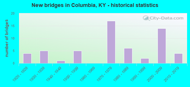
- New bridges - historical statistics
- 41920-1929
- 51930-1939
- 11940-1949
- 51950-1959
- 171970-1979
- 61980-1989
- 21990-1999
- 142000-2009
- 42010-2019

- Reconstructed bridges - Historical Statistics
- 21960-1969
- 01970-1979
- 01980-1989
- 01990-1999
- 02000-2009
- 12010-2019


- Bridge Condition - Deck
- 5.3%Very good
- 39.5%Good
- 39.5%Satisfactory
- 13.2%Fair
- 2.6%Poor

- Bridge Condition - Superstructure
- 13.2%Very good
- 31.6%Good
- 39.5%Satisfactory
- 15.8%Fair

- Bridge Condition - Substructure
- 2.6%Very good
- 44.7%Good
- 36.8%Satisfactory
- 15.8%Fair

- Bridge Condition - Channel
- 2.4%Excellent
- 21.4%Very good
- 38.1%Good
- 21.4%Satisfactory
- 11.9%Fair
- 4.8%Poor

- Bridge Condition - Culverts
- 8.3%Very good
- 8.3%Good
- 66.7%Satisfactory
- 16.7%Poor
Find on map >> Show street view
Structure Number: 1B00007N, Location: .05 MI SW OF JCT KY 1323 (Lat: 37.105556, Lng: -85.289167), Route carried "on" structure: State highway 206, Year Built: 1935, Status: Open, Structure Length: 7.32m (24.02ft), Average Daily Traffic: 5,713 (year 2018), Truck Traffic: 9%, Average Future Daily Traffic: 5,027 (year 2038), Design Load: H 20, Features Intersected: RUSSELL CREEK
Minimum Vertical Clearance: 30+ m (98+ ft), Kilometerpoint: 1.442, Lanes on structure: 2, Owner: State Highway Agency, Approaching Roadway Width: 6.7m (22.0ft), Skew: 3 degrees, Material/Design: Concrete, Design/Construction: Tee Beam, Number Of Spans In Main Unit: 5, Length of Maximum Span: 13.7m (44.9ft), Curb or Sidewalk Widths: Left: 0.2m (0.7ft), Right: 0.2m (0.7ft), Curb-To-Curb Width: 7.2m (23.6ft), Out-to-Out Width: 8.3m (27.2ft)
Condition: Deck: Good, Superstructure: Fair, Substructure: Satisfactory, Channel: Fair, Operating Rating: 66.0 metric tons, Method Used To Determine Operating Rating: Load Factor (LF), Inventory Rating: 39.6 metric tons, Method Used To Determine Inventory Rating: Load Factor (LF), Structural Evaluation: Somewhat better than minimum adequacy, Deck Geometry: High priority of replacement, Waterway Adequacy: Superior to present desirable criteria, Approach Roadway Alignment: Equal to present desirable criteria, Length Of Structure Improvement: 0.73m (2.40ft), Designated Inspection Frequency: Every 24 months, Inspection Date: July 2021, Bridge Improvement Cost: $750,000, Total Project Cost: $750,000, Deck Structure Type: Concrete Cast-file-Place, Wearing Surface/Protective System: Wearing Surface: Latex Concrete
Find on map >> Show street view
Structure Number: 1B00014N, Location: .10 MI WEST OF JCT KY 92 (Lat: 37.051944, Lng: -85.264167), Route carried "on" structure: State highway 55, Year Built: 1932, Status: Posted for load, Structure Length: 3.02m (9.91ft), Average Daily Traffic: 2,363 (year 2020), Truck Traffic: 9%, Average Future Daily Traffic: 2,079 (year 2040), Design Load: H 15, Features Intersected: GLENS FORK
Minimum Vertical Clearance: 30+ m (98+ ft), Kilometerpoint: 10.197, Lanes on structure: 2, Owner: State Highway Agency, Approaching Roadway Width: 6.1m (20.0ft), Material/Design: Concrete, Design/Construction: Tee Beam, Number Of Spans In Main Unit: 3, Length of Maximum Span: 9.1m (29.9ft), Curb-To-Curb Width: 7.3m (24.0ft), Out-to-Out Width: 8.2m (26.9ft)
Condition: Deck: Satisfactory, Superstructure: Satisfactory, Substructure: Satisfactory, Channel: Good, Operating Rating: 37.3 metric tons, Method Used To Determine Operating Rating: Load Factor (LF), Inventory Rating: 22.5 metric tons, Method Used To Determine Inventory Rating: Load Factor (LF), Structural Evaluation: Equal to present minimum criteria, Deck Geometry: High priority of replacement, Waterway Adequacy: Equal to present desirable criteria, Approach Roadway Alignment: Equal to present desirable criteria, Bridge Posting: Required (Relationship of Operating Rating to Maximum Legal Load: > 39.9% below), Length Of Structure Improvement: 0.30m (0.98ft), Designated Inspection Frequency: Every 12 months, Inspection Date: July 2021, Bridge Improvement Cost: $245,000, Total Project Cost: $245,000, Deck Structure Type: Concrete Cast-file-Place, Wearing Surface/Protective System: Wearing Surface: Monolithic Concrete, Deck Protection: Epoxy Coated Reinforcing
Find on map >> Show street view
Structure Number: 1B00021N, Location: 1.0 MI EAST OF JCT KY 959 (Lat: 37.079722, Lng: -85.373889), Route carried "on" structure: State highway 80, Year Built: 1935, Status: Open, Structure Length: 2.32m (7.61ft), Average Daily Traffic: 1,573 (year 2020), Truck Traffic: 7%, Average Future Daily Traffic: 1,384 (year 2040), Design Load: H 15, Features Intersected: BUTLERS FORK @BLISS
Minimum Vertical Clearance: 30+ m (98+ ft), Kilometerpoint: 15.747, Lanes on structure: 2, Owner: State Highway Agency, Approaching Roadway Width: 6.1m (20.0ft), Material/Design: Concrete, Design/Construction: Tee Beam, Number Of Spans In Main Unit: 2, Length of Maximum Span: 10.7m (35.1ft), Curb-To-Curb Width: 7.2m (23.6ft), Out-to-Out Width: 8.3m (27.2ft)
Condition: Deck: Satisfactory, Superstructure: Satisfactory, Substructure: Satisfactory, Channel: Good, Operating Rating: 62.0 metric tons, Method Used To Determine Operating Rating: Load Factor (LF), Inventory Rating: 37.2 metric tons, Method Used To Determine Inventory Rating: Load Factor (LF), Structural Evaluation: Equal to present minimum criteria, Deck Geometry: High priority of corrective action, Waterway Adequacy: Equal to present desirable criteria, Approach Roadway Alignment: Equal to present desirable criteria, Designated Inspection Frequency: Every 24 months, Inspection Date: July 2021, Deck Structure Type: Concrete Cast-file-Place, Wearing Surface/Protective System: Wearing Surface: Latex Concrete
Find on map >> Show street view
Structure Number: 1B00025N, Location: 1.2 MI W OF NE-JCT KY 80 (Lat: 37.099167, Lng: -85.337500), Route carried "on" structure: State highway 61, Year Built: 1926, Year Reconstructed: 1968, Status: Open, Structure Length: 2.93m (9.61ft), Average Daily Traffic: 2,315 (year 2019), Truck Traffic: 10%, Average Future Daily Traffic: 1,921 (year 2039), Design Load: H 20, Features Intersected: PETTYS FORK CREEK
Minimum Vertical Clearance: 30+ m (98+ ft), Kilometerpoint: 20.215, Lanes on structure: 2, Base Highway Network: Yes, Owner: State Highway Agency, Approaching Roadway Width: 6.7m (22.0ft), Material/Design: Concrete, Design/Construction: Tee Beam, Number Of Spans In Main Unit: 2, Length of Maximum Span: 13.7m (44.9ft), Curb or Sidewalk Widths: Left: 0.3m (1.0ft), Right: 0.3m (1.0ft), Curb-To-Curb Width: 8.5m (27.9ft), Out-to-Out Width: 9.7m (31.8ft)
Condition: Deck: Satisfactory, Superstructure: Satisfactory, Substructure: Fair, Channel: Good, Operating Rating: 55.2 metric tons, Method Used To Determine Operating Rating: Load Factor (LF), Inventory Rating: 33.1 metric tons, Method Used To Determine Inventory Rating: Load Factor (LF), Structural Evaluation: Somewhat better than minimum adequacy, Deck Geometry: Meets minimum limits, Waterway Adequacy: Superior to present desirable criteria, Approach Roadway Alignment: Equal to present desirable criteria, Designated Inspection Frequency: Every 24 months, Inspection Date: July 2021, Deck Structure Type: Concrete Cast-file-Place, Wearing Surface/Protective System: Wearing Surface: Latex Concrete
Find on map >> Show street view
Structure Number: 1B00026N, Location: .5 MI S OF N-JCT KY 768 (Lat: 37.119167, Lng: -85.393333), Route carried "on" structure: State highway 61, Year Built: 1925, Year Reconstructed: 1968, Status: Open, Structure Length: 8.08m (26.51ft), Average Daily Traffic: 2,315 (year 2019), Truck Traffic: 10%, Average Future Daily Traffic: 1,921 (year 2039), Design Load: H 20, Features Intersected: RUSSELL CREEK
Minimum Vertical Clearance: 30+ m (98+ ft), Kilometerpoint: 26.876, Lanes on structure: 2, Base Highway Network: Yes, Owner: State Highway Agency, Approaching Roadway Width: 7.9m (25.9ft), Material/Design: Concrete, Design/Construction: Tee Beam, Number Of Spans In Main Unit: 5, Length of Maximum Span: 15.2m (49.9ft), Curb or Sidewalk Widths: Left: 0.3m (1.0ft), Right: 0.3m (1.0ft), Curb-To-Curb Width: 8.5m (27.9ft), Out-to-Out Width: 9.7m (31.8ft)
Condition: Deck: Fair, Superstructure: Fair, Substructure: Fair, Channel: Poor, Operating Rating: 52.9 metric tons, Method Used To Determine Operating Rating: Load Factor (LF), Inventory Rating: 31.8 metric tons, Method Used To Determine Inventory Rating: Load Factor (LF), Structural Evaluation: Somewhat better than minimum adequacy, Deck Geometry: Meets minimum limits, Waterway Adequacy: Superior to present desirable criteria, Approach Roadway Alignment: Equal to present desirable criteria, Designated Inspection Frequency: Every 24 months, Inspection Date: July 2021, Deck Structure Type: Concrete Cast-file-Place, Wearing Surface/Protective System: Wearing Surface: Latex Concrete
Find on map >> Show street view
Structure Number: 1B00032N, Location: .3 MI NE OF JCT KY 206 (Lat: 37.110556, Lng: -85.284444), Route carried "on" structure: State highway 1323, Year Built: 1952, Status: Posted for load, Structure Length: 2.32m (7.61ft), Average Daily Traffic: 378 (year 2019), Average Future Daily Traffic: 328 (year 2039), Design Load: H 15, Features Intersected: BULL RUN CREEK
Minimum Vertical Clearance: 30+ m (98+ ft), Kilometerpoint: 0.660, Lanes on structure: 2, Owner: State Highway Agency, Approaching Roadway Width: 5.5m (18.0ft), Skew: 4 degrees, Material/Design: Concrete, Design/Construction: Tee Beam, Number Of Spans In Main Unit: 2, Length of Maximum Span: 10.7m (35.1ft), Curb or Sidewalk Widths: Left: 0.3m (1.0ft), Right: 0.3m (1.0ft), Curb-To-Curb Width: 5.5m (18.0ft), Out-to-Out Width: 6.8m (22.3ft)
Condition: Deck: Good, Superstructure: Satisfactory, Substructure: Satisfactory, Channel: Good, Operating Rating: 46.8 metric tons, Method Used To Determine Operating Rating: Load Factor (LF), Inventory Rating: 28.1 metric tons, Method Used To Determine Inventory Rating: Load Factor (LF), Structural Evaluation: Equal to present minimum criteria, Deck Geometry: High priority of corrective action, Waterway Adequacy: Superior to present desirable criteria, Approach Roadway Alignment: Equal to present minimum criteria, Bridge Posting: Required (Relationship of Operating Rating to Maximum Legal Load: 20.0 - 29.9% below), Length Of Structure Improvement: 0.23m (0.75ft), Designated Inspection Frequency: Every 24 months, Inspection Date: July 2021, Bridge Improvement Cost: $190,000, Total Project Cost: $190,000, Deck Structure Type: Concrete Cast-file-Place, Wearing Surface/Protective System: Wearing Surface: Latex Concrete
Find on map >> Show street view
Structure Number: 1B00035N, Location: .50 MI NOR. OF JCT KY 901 (Lat: 37.135833, Lng: -85.291667), Route carried "on" structure: State highway 551, Year Built: 1955, Status: Posted for load, Structure Length: 1.18m (3.87ft), Average Daily Traffic: 2,007 (year 2020), Truck Traffic: 7%, Average Future Daily Traffic: 1,766 (year 2040), Design Load: H 15, Features Intersected: BUTLERS BRANCH
Minimum Vertical Clearance: 30+ m (98+ ft), Kilometerpoint: 1.389, Lanes on structure: 2, Owner: State Highway Agency, Approaching Roadway Width: 6.1m (20.0ft), Skew: 4 degrees, Material/Design: Concrete, Design/Construction: Culvert, Number Of Spans In Main Unit: 2, Length of Maximum Span: 7.7m (25.3ft), Curb-To-Curb Width: 7.4m (24.3ft), Out-to-Out Width: 8.0m (26.2ft)
Condition: Channel: Fair, Culverts: Satisfactory, Operating Rating: 43.6 metric tons, Method Used To Determine Operating Rating: Load Factor (LF), Inventory Rating: 26.1 metric tons, Method Used To Determine Inventory Rating: Load Factor (LF), Structural Evaluation: Equal to present minimum criteria, Deck Geometry: High priority of replacement, Waterway Adequacy: Equal to present minimum criteria, Approach Roadway Alignment: Equal to present desirable criteria, Bridge Posting: Required (Relationship of Operating Rating to Maximum Legal Load: > 39.9% below), Designated Inspection Frequency: Every 24 months, Inspection Date: July 2021
Find on map >> Show street view
Structure Number: 1B00036N, Location: .70 MI NOR. OF JCT KY 901 (Lat: 37.139167, Lng: -85.290278), Route carried "on" structure: State highway 551, Year Built: 1955, Status: Posted for load, Structure Length: 0.75m (2.46ft), Average Daily Traffic: 2,007 (year 2020), Truck Traffic: 7%, Average Future Daily Traffic: 1,766 (year 2040), Design Load: H 15, Features Intersected: BUTLERS BRANCH
Minimum Vertical Clearance: 30+ m (98+ ft), Kilometerpoint: 1.775, Lanes on structure: 2, Owner: State Highway Agency, Approaching Roadway Width: 5.5m (18.0ft), Material/Design: Concrete, Design/Construction: Culvert, Number Of Spans In Main Unit: 2, Length of Maximum Span: 3.4m (11.2ft), Curb-To-Curb Width: 7.9m (25.9ft), Out-to-Out Width: 8.5m (27.9ft)
Condition: Channel: Satisfactory, Culverts: Poor, Operating Rating: 33.9 metric tons, Method Used To Determine Operating Rating: Load Factor (LF), Inventory Rating: 20.3 metric tons, Method Used To Determine Inventory Rating: Load Factor (LF), Structural Evaluation: Meets minimum limits, Deck Geometry: High priority of corrective action, Waterway Adequacy: Equal to present minimum criteria, Approach Roadway Alignment: Equal to present minimum criteria, Bridge Posting: Required (Relationship of Operating Rating to Maximum Legal Load: > 39.9% below), Designated Inspection Frequency: Every 12 months, Inspection Date: July 2021
Find on map >> Show street view
Structure Number: 1B00037N, Location: 1.3 MI EAST OF 084 C.L. (Lat: 37.149444, Lng: -85.287500), Route carried "on" structure: State highway 551, Year Built: 1955, Status: Posted for load, Structure Length: 0.75m (2.46ft), Average Daily Traffic: 2,007 (year 2020), Truck Traffic: 7%, Average Future Daily Traffic: 1,766 (year 2040), Design Load: H 15, Features Intersected: BUTLERS BRANCH
Minimum Vertical Clearance: 30+ m (98+ ft), Kilometerpoint: 2.948, Lanes on structure: 2, Owner: State Highway Agency, Approaching Roadway Width: 5.8m (19.0ft), Material/Design: Concrete, Design/Construction: Culvert, Number Of Spans In Main Unit: 2, Length of Maximum Span: 3.4m (11.2ft), Curb-To-Curb Width: 7.9m (25.9ft), Out-to-Out Width: 8.5m (27.9ft)
Condition: Channel: Poor, Culverts: Poor, Operating Rating: 33.2 metric tons, Method Used To Determine Operating Rating: Load Factor (LF), Inventory Rating: 20.0 metric tons, Method Used To Determine Inventory Rating: Load Factor (LF), Structural Evaluation: Meets minimum limits, Deck Geometry: High priority of corrective action, Waterway Adequacy: Equal to present minimum criteria, Approach Roadway Alignment: Equal to present desirable criteria, Bridge Posting: Required (Relationship of Operating Rating to Maximum Legal Load: > 39.9% below), Designated Inspection Frequency: Every 12 months, Inspection Date: July 2021
Find on map >> Show street view
Structure Number: 1B00052N, Location: .10 MI NOR. OF JCT KY 206 (Lat: 37.108889, Lng: -85.303056), Route carried "on" structure: Business State highway 55, Year Built: 1950, Status: Posted for load, Structure Length: 5.24m (17.19ft), Average Daily Traffic: 8,253 (year 2020), Truck Traffic: 16%, Average Future Daily Traffic: 6,849 (year 2040), Design Load: H 20, Features Intersected: RUSSELL CREEK
Minimum Vertical Clearance: 30+ m (98+ ft), Kilometerpoint: 3.199, Lanes on structure: 2, Base Highway Network: Yes, Owner: State Highway Agency, Approaching Roadway Width: 6.7m (22.0ft), Material/Design: Concrete, Design/Construction: Tee Beam, Number Of Spans In Main Unit: 4, Length of Maximum Span: 12.2m (40.0ft), Curb or Sidewalk Widths: Left: 1.6m (5.2ft), Right: 1.6m (5.2ft), Curb-To-Curb Width: 7.9m (25.9ft), Out-to-Out Width: 11.7m (38.4ft)
Condition: Deck: Satisfactory, Superstructure: Satisfactory, Substructure: Satisfactory, Channel: Fair, Operating Rating: 51.7 metric tons, Method Used To Determine Operating Rating: Load Factor (LF), Inventory Rating: 31.0 metric tons, Method Used To Determine Inventory Rating: Load Factor (LF), Structural Evaluation: Equal to present minimum criteria, Deck Geometry: High priority of replacement, Waterway Adequacy: Superior to present desirable criteria, Approach Roadway Alignment: Equal to present desirable criteria, Bridge Posting: Required (Relationship of Operating Rating to Maximum Legal Load: 10.0 - 19.9% below), Length Of Structure Improvement: 0.52m (1.71ft), Designated Inspection Frequency: Every 24 months, Inspection Date: July 2021, Bridge Improvement Cost: $774,000, Total Project Cost: $774,000, Deck Structure Type: Concrete Cast-file-Place, Wearing Surface/Protective System: Wearing Surface: Latex Concrete
Find on map >> Show street view
Structure Number: 1B00060N, Location: 2.0 MI WEST OF KY 61 OP (Lat: 37.073056, Lng: -85.378889), Route carried "on" structure: State highway 9008, Year Built: 1972, Status: Open, Structure Length: 1.16m (3.81ft), Average Daily Traffic: 4,509 (year 2020), Truck Traffic: 29%, Average Future Daily Traffic: 4,238 (year 2040), Design Load: HS 20+Mod, Features Intersected: BUTLERS FORK
Minimum Vertical Clearance: 30+ m (98+ ft), Kilometerpoint: 71.526, Lanes on structure: 4, Base Highway Network: Yes, Owner: State Highway Agency, Approaching Roadway Width: 23.2m (76.1ft), Skew: 21 degrees, Material/Design: Concrete, Design/Construction: Culvert, Number Of Spans In Main Unit: 2, Length of Maximum Span: 5.1m (16.7ft)
Condition: Channel: Very good, Culverts: Satisfactory, Operating Rating: 99.8 metric tons, Method Used To Determine Operating Rating: Load Factor (LF), Inventory Rating: 99.8 metric tons, Method Used To Determine Inventory Rating: Load Factor (LF), Structural Evaluation: Equal to present minimum criteria, Waterway Adequacy: Superior to present desirable criteria, Approach Roadway Alignment: Equal to present desirable criteria, Designated Inspection Frequency: Every 24 months, Inspection Date: July 2021
Find on map >> Show street view
Structure Number: 1B00061N, Location: 3.5 MI W OF KY 55 NTRCH (Lat: 37.073056, Lng: -85.363889), Route carried "on" structure: State highway 9008, Year Built: 1972, Status: Open, Structure Length: 0.88m (2.89ft), Average Daily Traffic: 4,509 (year 2020), Truck Traffic: 29%, Average Future Daily Traffic: 4,238 (year 2040), Design Load: HS 20+Mod, Features Intersected: BLISS ROAD
Minimum Vertical Clearance: 30+ m (98+ ft), Kilometerpoint: 72.852, Lanes on structure: 4, Lanes under structure: 2, Base Highway Network: Yes, Owner: State Highway Agency, Approaching Roadway Width: 23.2m (76.1ft), Skew: 21 degrees, Material/Design: Concrete, Design/Construction: Culvert, Number Of Spans In Main Unit: 1, Length of Maximum Span: 7.7m (25.3ft)
Condition: Culverts: Satisfactory, Operating Rating: 87.7 metric tons, Method Used To Determine Operating Rating: Load Factor (LF), Inventory Rating: 52.6 metric tons, Method Used To Determine Inventory Rating: Load Factor (LF), Structural Evaluation: Equal to present minimum criteria, Underclear: High priority of corrective action, Approach Roadway Alignment: Equal to present desirable criteria, Length Of Structure Improvement: 0.09m (0.30ft), Designated Inspection Frequency: Every 24 months, Inspection Date: July 2021, Bridge Improvement Cost: $72,000, Total Project Cost: $72,000
Find on map >> Show street view
Structure Number: 1B00062L, Location: WBL .7 MI W OF KY 55 NTRC (Lat: 37.082778, Lng: -85.315556), Route carried "on" structure: State highway 9008, Year Built: 1972, Status: Open, Structure Length: 6.36m (20.87ft), Average Daily Traffic: 3,723 (year 2020), Truck Traffic: 21%, Average Future Daily Traffic: 3,499 (year 2040), Design Load: HS 20+Mod, Features Intersected: PETTY'S FORK
Minimum Vertical Clearance: 30+ m (98+ ft), Kilometerpoint: 77.467, Lanes on structure: 2, Base Highway Network: Yes, Owner: State Highway Agency, Approaching Roadway Width: 11.6m (38.1ft), Skew: 1 degrees, Material/Design: Prestressed concrete continuous, Design/Construction: Stringer/Multi-beam, Number Of Spans In Main Unit: 3, Length of Maximum Span: 22.6m (74.1ft), Curb or Sidewalk Widths: Left: 0.2m (0.7ft), Right: 0.2m (0.7ft), Curb-To-Curb Width: 9.1m (29.9ft), Out-to-Out Width: 10.2m (33.5ft)
Condition: Deck: Good, Superstructure: Good, Substructure: Good, Channel: Very good, Operating Rating: 99.8 metric tons, Method Used To Determine Operating Rating: Load Factor (LF), Inventory Rating: 63.7 metric tons, Method Used To Determine Inventory Rating: Load Factor (LF), Structural Evaluation: Better than present minimum criteria, Deck Geometry: Meets minimum limits, Waterway Adequacy: Equal to present desirable criteria, Approach Roadway Alignment: Equal to present desirable criteria, Designated Inspection Frequency: Every 24 months, Inspection Date: July 2021, Deck Structure Type: Concrete Cast-file-Place, Wearing Surface/Protective System: Wearing Surface: Latex Concrete
Find on map >> Show street view
Structure Number: 1B00062R, Location: EBL .7 MI W OF KY 55 NTRC (Lat: 37.082778, Lng: -85.315556), Route carried "on" structure: State highway 9008, Year Built: 1972, Status: Open, Structure Length: 6.36m (20.87ft), Average Daily Traffic: 3,723 (year 2020), Truck Traffic: 21%, Average Future Daily Traffic: 3,499 (year 2040), Design Load: HS 20+Mod, Features Intersected: PETTY'S FORK
Minimum Vertical Clearance: 30+ m (98+ ft), Kilometerpoint: 77.459, Lanes on structure: 2, Base Highway Network: Yes, Owner: State Highway Agency, Approaching Roadway Width: 11.6m (38.1ft), Skew: 1 degrees, Material/Design: Prestressed concrete continuous, Design/Construction: Stringer/Multi-beam, Number Of Spans In Main Unit: 3, Length of Maximum Span: 22.6m (74.1ft), Curb or Sidewalk Widths: Left: 0.2m (0.7ft), Right: 0.2m (0.7ft), Curb-To-Curb Width: 9.1m (29.9ft), Out-to-Out Width: 10.2m (33.5ft)
Condition: Deck: Good, Superstructure: Good, Substructure: Good, Channel: Very good, Operating Rating: 99.8 metric tons, Method Used To Determine Operating Rating: Load Factor (LF), Inventory Rating: 63.7 metric tons, Method Used To Determine Inventory Rating: Load Factor (LF), Structural Evaluation: Better than present minimum criteria, Deck Geometry: Meets minimum limits, Waterway Adequacy: Equal to present desirable criteria, Approach Roadway Alignment: Equal to present desirable criteria, Designated Inspection Frequency: Every 24 months, Inspection Date: July 2021, Deck Structure Type: Concrete Cast-file-Place, Wearing Surface/Protective System: Wearing Surface: Latex Concrete
Find on map >> Show street view
Structure Number: 1B00063L, Location: WBL .8 MI E OF KY 55 NTRC (Lat: 37.089722, Lng: -85.282500), Route carried "on" structure: State highway 9008, Year Built: 1972, Status: Open, Structure Length: 8.88m (29.13ft), Average Daily Traffic: 3,455 (year 2020), Truck Traffic: 21%, Average Future Daily Traffic: 3,247 (year 2040), Design Load: HS 20+Mod, Features Intersected: RUSSELL CREEK
Minimum Vertical Clearance: 30+ m (98+ ft), Kilometerpoint: 80.633, Lanes on structure: 2, Base Highway Network: Yes, Owner: State Highway Agency, Approaching Roadway Width: 11.6m (38.1ft), Skew: 5 degrees, Material/Design: Steel continuous, Design/Construction: Stringer/Multi-beam, Number Of Spans In Main Unit: 4, Length of Maximum Span: 30.5m (100.1ft), Curb or Sidewalk Widths: Left: 0.2m (0.7ft), Right: 0.2m (0.7ft), Curb-To-Curb Width: 9.1m (29.9ft), Out-to-Out Width: 10.2m (33.5ft)
Condition: Deck: Fair, Superstructure: Satisfactory, Substructure: Satisfactory, Channel: Good, Operating Rating: 61.2 metric tons, Method Used To Determine Operating Rating: Load Factor (LF), Inventory Rating: 36.7 metric tons, Method Used To Determine Inventory Rating: Load Factor (LF), Structural Evaluation: Equal to present minimum criteria, Deck Geometry: Meets minimum limits, Waterway Adequacy: Superior to present desirable criteria, Approach Roadway Alignment: Equal to present desirable criteria, Designated Inspection Frequency: Every 24 months, Inspection Date: July 2021, Deck Structure Type: Concrete Cast-file-Place, Wearing Surface/Protective System: Wearing Surface: Monolithic Concrete
Find on map >> Show street view
Structure Number: 1B00063R, Location: EBL .8 MI E OF KY 55 NTRC (Lat: 37.089722, Lng: -85.282778), Route carried "on" structure: State highway 9008, Year Built: 1972, Status: Open, Structure Length: 8.88m (29.13ft), Average Daily Traffic: 3,455 (year 2020), Truck Traffic: 21%, Average Future Daily Traffic: 3,247 (year 2040), Design Load: HS 20+Mod, Features Intersected: RUSSELL CREEK
Minimum Vertical Clearance: 30+ m (98+ ft), Kilometerpoint: 80.578, Lanes on structure: 2, Base Highway Network: Yes, Owner: State Highway Agency, Approaching Roadway Width: 23.2m (76.1ft), Skew: 5 degrees, Material/Design: Steel continuous, Design/Construction: Stringer/Multi-beam, Number Of Spans In Main Unit: 4, Length of Maximum Span: 30.5m (100.1ft), Curb or Sidewalk Widths: Left: 0.2m (0.7ft), Right: 0.2m (0.7ft), Curb-To-Curb Width: 9.1m (29.9ft), Out-to-Out Width: 10.2m (33.5ft)
Condition: Deck: Fair, Superstructure: Satisfactory, Substructure: Satisfactory, Channel: Good, Operating Rating: 61.2 metric tons, Method Used To Determine Operating Rating: Load Factor (LF), Inventory Rating: 36.7 metric tons, Method Used To Determine Inventory Rating: Load Factor (LF), Structural Evaluation: Equal to present minimum criteria, Deck Geometry: Meets minimum limits, Waterway Adequacy: Superior to present desirable criteria, Approach Roadway Alignment: Equal to present desirable criteria, Designated Inspection Frequency: Every 24 months, Inspection Date: July 2021, Deck Structure Type: Concrete Cast-file-Place, Wearing Surface/Protective System: Wearing Surface: Monolithic Concrete
Find on map >> Show street view
Structure Number: 1B00064N, Location: 1.4 MI E OF KY 55 NTRCH (Lat: 37.089167, Lng: -85.278056), Route carried "on" structure: State highway 9008, Year Built: 1971, Status: Open, Structure Length: 0.82m (2.69ft), Average Daily Traffic: 6,909 (year 2020), Truck Traffic: 21%, Average Future Daily Traffic: 6,494 (year 2040), Features Intersected: Conover RD
Minimum Vertical Clearance: 30+ m (98+ ft), Kilometerpoint: 80.995, Lanes on structure: 4, Lanes under structure: 2, Base Highway Network: Yes, Owner: State Highway Agency, Approaching Roadway Width: 23.2m (76.1ft), Skew: 20 degrees, Material/Design: Concrete, Design/Construction: Culvert, Number Of Spans In Main Unit: 1, Length of Maximum Span: 7.3m (24.0ft)
Condition: Culverts: Satisfactory, Operating Rating: 54.4 metric tons, Method Used To Determine Operating Rating: Field evaluation and documented engineering judgment, Inventory Rating: 39.9 metric tons, Method Used To Determine Inventory Rating: Field evaluation and documented engineering judgment, Structural Evaluation: Equal to present minimum criteria, Underclear: High priority of corrective action, Approach Roadway Alignment: Equal to present desirable criteria, Designated Inspection Frequency: Every 24 months, Inspection Date: July 2021
Find on map >> Show street view
Structure Number: 1B00065N, Location: .1 MI S OF JCT KY 80 (Lat: 37.087222, Lng: -85.266111), Route carried "on" structure: County highway 1845, Year Built: 1972, Status: Open, Structure Length: 7.30m (23.95ft), Average Daily Traffic: 183 (year 2018), Average Future Daily Traffic: 159 (year 2038), Design Load: H 20, Features Intersected: LN-9008
Minimum Vertical Clearance: 30+ m (98+ ft), Kilometerpoint: 0.167, Lanes on structure: 2, Lanes under structure: 4, Owner: State Highway Agency, Approaching Roadway Width: 6.1m (20.0ft), Skew: 22 degrees, Material/Design: Concrete continuous, Design/Construction: Tee Beam, Number Of Spans In Main Unit: 4, Length of Maximum Span: 19.2m (63.0ft), Curb or Sidewalk Widths: Left: 0.2m (0.7ft), Right: 0.2m (0.7ft), Curb-To-Curb Width: 7.9m (25.9ft), Out-to-Out Width: 9.0m (29.5ft)
Condition: Deck: Satisfactory, Superstructure: Good, Substructure: Good, Operating Rating: 75.8 metric tons, Method Used To Determine Operating Rating: Load Factor (LF), Inventory Rating: 45.4 metric tons, Method Used To Determine Inventory Rating: Load Factor (LF), Structural Evaluation: Better than present minimum criteria, Deck Geometry: Somewhat better than minimum adequacy, Underclear: Equal to present minimum criteria, Approach Roadway Alignment: Equal to present desirable criteria, Designated Inspection Frequency: Every 24 months, Inspection Date: July 2021, Deck Structure Type: Concrete Cast-file-Place, Wearing Surface/Protective System: Wearing Surface: Monolithic Concrete
Find on map >> Show street view
Structure Number: 1B00066N, Location: 3.6 MI E OF KY 55 NTRCH (Lat: 37.078889, Lng: -85.239444), Route carried "on" structure: State highway 9008, Year Built: 1971, Status: Open, Structure Length: 0.88m (2.89ft), Average Daily Traffic: 6,909 (year 2020), Truck Traffic: 21%, Average Future Daily Traffic: 6,494 (year 2040), Features Intersected: ARNOLD KEENE WILSON ROAD
Minimum Vertical Clearance: 30+ m (98+ ft), Kilometerpoint: 84.619, Lanes on structure: 4, Lanes under structure: 2, Base Highway Network: Yes, Owner: State Highway Agency, Approaching Roadway Width: 23.2m (76.1ft), Skew: 22 degrees, Material/Design: Concrete, Design/Construction: Culvert, Number Of Spans In Main Unit: 1, Length of Maximum Span: 7.9m (25.9ft)
Condition: Culverts: Satisfactory, Operating Rating: 54.4 metric tons, Method Used To Determine Operating Rating: Field evaluation and documented engineering judgment, Inventory Rating: 39.9 metric tons, Method Used To Determine Inventory Rating: Field evaluation and documented engineering judgment, Structural Evaluation: Equal to present minimum criteria, Underclear: High priority of corrective action, Approach Roadway Alignment: Equal to present desirable criteria, Designated Inspection Frequency: Every 24 months, Inspection Date: July 2021
Find on map >> Show street view
Structure Number: 1B00067N, Location: 4.0 MI EAST OF KY 55 NTRC (Lat: 37.075556, Lng: -85.229722), Route carried "on" structure: State highway 9008, Year Built: 1972, Status: Open, Structure Length: 0.81m (2.66ft), Average Daily Traffic: 6,909 (year 2020), Truck Traffic: 21%, Average Future Daily Traffic: 6,494 (year 2040), Design Load: HS 20, Features Intersected: SHILOH ROAD
Minimum Vertical Clearance: 30+ m (98+ ft), Kilometerpoint: 85.575, Lanes on structure: 4, Lanes under structure: 2, Base Highway Network: Yes, Owner: State Highway Agency, Approaching Roadway Width: 23.2m (76.1ft), Skew: 20 degrees, Material/Design: Concrete, Design/Construction: Culvert, Number Of Spans In Main Unit: 1, Length of Maximum Span: 7.3m (24.0ft)
Condition: Culverts: Satisfactory, Operating Rating: 52.3 metric tons, Method Used To Determine Operating Rating: Load Factor (LF), Inventory Rating: 31.4 metric tons, Method Used To Determine Inventory Rating: Load Factor (LF), Structural Evaluation: Equal to present minimum criteria, Underclear: High priority of corrective action, Approach Roadway Alignment: Equal to present desirable criteria, Designated Inspection Frequency: Every 24 months, Inspection Date: July 2021
Find on map >> Show street view
Structure Number: 1B00071N, Location: .05 MI NOR. OF JCT KY 551 (Lat: 37.125278, Lng: -85.295556), Route carried "on" structure: State highway 55, Year Built: 1973, Status: Open, Structure Length: 0.85m (2.79ft), Average Daily Traffic: 7,242 (year 2018), Truck Traffic: 16%, Average Future Daily Traffic: 6,807 (year 2038), Design Load: H 20, Features Intersected: BUTLERS BRANCH
Minimum Vertical Clearance: 30+ m (98+ ft), Kilometerpoint: 24.600, Lanes on structure: 2, Base Highway Network: Yes, Owner: State Highway Agency, Approaching Roadway Width: 7.3m (24.0ft), Skew: 1 degrees, Material/Design: Concrete, Design/Construction: Culvert, Number Of Spans In Main Unit: 2, Length of Maximum Span: 3.8m (12.5ft)
Condition: Channel: Satisfactory, Culverts: Satisfactory, Operating Rating: 99.8 metric tons, Method Used To Determine Operating Rating: Load Factor (LF), Inventory Rating: 99.8 metric tons, Method Used To Determine Inventory Rating: Load Factor (LF), Structural Evaluation: Equal to present minimum criteria, Waterway Adequacy: Equal to present desirable criteria, Approach Roadway Alignment: Equal to present desirable criteria, Designated Inspection Frequency: Every 24 months, Inspection Date: July 2021
Find on map >> Show street view
Structure Number: 1B00074N, Location: 1.9 MI.N. JCT KY 439 (Lat: 37.128056, Lng: -85.324167), Route carried "on" structure: State highway 767, Year Built: 1983, Status: Posted for load, Structure Length: 6.23m (20.44ft), Average Daily Traffic: 603 (year 2020), Average Future Daily Traffic: 530 (year 2040), Design Load: HS 20, Features Intersected: RUSSELL CREEK
Minimum Vertical Clearance: 30+ m (98+ ft), Kilometerpoint: 2.942, Lanes on structure: 2, Owner: State Highway Agency, Approaching Roadway Width: 6.1m (20.0ft), Material/Design: Prestressed concrete continuous, Design/Construction: Box Beam or Girders - Single/Spread, Number Of Spans In Main Unit: 3, Length of Maximum Span: 30.5m (100.1ft), Curb-To-Curb Width: 7.3m (24.0ft), Out-to-Out Width: 8.3m (27.2ft)
Condition: Deck: Satisfactory, Superstructure: Satisfactory, Substructure: Good, Channel: Good, Operating Rating: 38.6 metric tons, Method Used To Determine Operating Rating: Load Factor (LF), Inventory Rating: 23.2 metric tons, Method Used To Determine Inventory Rating: Load Factor (LF), Structural Evaluation: Equal to present minimum criteria, Deck Geometry: Meets minimum limits, Waterway Adequacy: Somewhat better than minimum adequacy, Approach Roadway Alignment: Equal to present minimum criteria, Bridge Posting: Required (Relationship of Operating Rating to Maximum Legal Load: 20.0 - 29.9% below), Designated Inspection Frequency: Every 24 months, Inspection Date: July 2021, Deck Structure Type: Concrete Cast-file-Place, Wearing Surface/Protective System: Wearing Surface: Monolithic Concrete, Deck Protection: Epoxy Coated Reinforcing
Find on map >> Show street view
Structure Number: 1B00077N, Location: 750' S JCT KY 206 (Lat: 37.102500, Lng: -85.288611), Route carried "on" structure: State highway 3491, Year Built: 1993, Status: Open, Structure Length: 11.42m (37.47ft), Average Daily Traffic: 2,430 (year 2018), Average Future Daily Traffic: 2,138 (year 2038), Design Load: HS 25 or greater, Features Intersected: RUSSELL CREEK
Minimum Vertical Clearance: 30+ m (98+ ft), Kilometerpoint: 2.123, Lanes on structure: 2, Owner: State Highway Agency, Approaching Roadway Width: 6.1m (20.0ft), Material/Design: Prestressed concrete continuous, Design/Construction: Stringer/Multi-beam, Number Of Spans In Main Unit: 4, Length of Maximum Span: 32.0m (105.0ft), Curb-To-Curb Width: 9.1m (29.9ft), Out-to-Out Width: 10.1m (33.1ft)
Condition: Deck: Good, Superstructure: Good, Substructure: Good, Channel: Very good, Operating Rating: 69.7 metric tons, Method Used To Determine Operating Rating: Load Factor (LF), Inventory Rating: 41.8 metric tons, Method Used To Determine Inventory Rating: Load Factor (LF), Structural Evaluation: Better than present minimum criteria, Deck Geometry: Meets minimum limits, Waterway Adequacy: Superior to present desirable criteria, Approach Roadway Alignment: Equal to present desirable criteria, Designated Inspection Frequency: Every 24 months, Inspection Date: July 2021, Deck Structure Type: Concrete Cast-file-Place, Wearing Surface/Protective System: Wearing Surface: Monolithic Concrete, Deck Protection: Epoxy Coated Reinforcing
Find on map >> Show street view
Structure Number: 1B00078N, Location: .85 MI S. JCT KY 55 (Lat: 37.067778, Lng: -85.305833), Route carried "on" structure: State highway 704, Year Built: 1940, Year Reconstructed: 2019, Status: Open, Structure Length: 1.15m (3.77ft), Average Daily Traffic: 1,535 (year 2018), Average Future Daily Traffic: 1,350 (year 2038), Design Load: Greater than HL93, Features Intersected: UNNAMED STREAM
Minimum Vertical Clearance: 30+ m (98+ ft), Kilometerpoint: 19.166, Lanes on structure: 2, Owner: State Highway Agency, Approaching Roadway Width: 6.4m (21.0ft), Skew: 4 degrees, Material/Design: Concrete, Design/Construction: Slab, Number Of Spans In Main Unit: 3, Length of Maximum Span: 3.4m (11.2ft), Curb-To-Curb Width: 7.4m (24.3ft), Out-to-Out Width: 8.0m (26.2ft)
Condition: Deck: Very good, Superstructure: Very good, Substructure: Good, Channel: Good, Operating Rating: 77.1 metric tons, Method Used To Determine Operating Rating: Load and Resistance Factor Rating (LRFR) rating reported by rating factor(RF) method using HL-93 loadings, Inventory Rating: 59.6 metric tons, Method Used To Determine Inventory Rating: Load and Resistance Factor Rating (LRFR) rating reported by rating factor(RF) method using HL-93 loadings, Structural Evaluation: Better than present minimum criteria, Deck Geometry: Meets minimum limits, Waterway Adequacy: Equal to present minimum criteria, Approach Roadway Alignment: Equal to present desirable criteria, Designated Inspection Frequency: Every 24 months, Inspection Date: July 2021, Deck Structure Type: Concrete Cast-file-Place, Wearing Surface/Protective System: Wearing Surface: Monolithic Concrete, Deck Protection: Epoxy Coated Reinforcing
Find on map >> Show street view
Structure Number: 1B00082N, Location: 1.05 MILES SOUTH OF KY 80 (Lat: 37.086111, Lng: -85.323889), Route carried "on" structure: State highway 61, Year Built: 2007, Status: Open, Structure Length: 16.86m (55.31ft), Average Daily Traffic: 7,689 (year 2020), Truck Traffic: 11%, Average Future Daily Traffic: 6,381 (year 2040), Design Load: HS 25 or greater, Features Intersected: PETTY'S FORK
Minimum Vertical Clearance: 30+ m (98+ ft), Kilometerpoint: 19.225, Lanes on structure: 4, Base Highway Network: Yes, Owner: State Highway Agency, Approaching Roadway Width: 25.0m (82.0ft), Skew: 22 degrees, Material/Design: Prestressed concrete continuous, Design/Construction: Stringer/Multi-beam, Number Of Spans In Main Unit: 6, Length of Maximum Span: 34.1m (111.9ft), Curb-To-Curb Width: 25.0m (82.0ft), Out-to-Out Width: 25.9m (85.0ft)
Condition: Deck: Good, Superstructure: Very good, Substructure: Good, Channel: Very good, Operating Rating: 69.9 metric tons, Method Used To Determine Operating Rating: Load Factor (LF), Inventory Rating: 41.9 metric tons, Method Used To Determine Inventory Rating: Load Factor (LF), Structural Evaluation: Better than present minimum criteria, Deck Geometry: Superior to present desirable criteria, Waterway Adequacy: Superior to present desirable criteria, Approach Roadway Alignment: Equal to present desirable criteria, Designated Inspection Frequency: Every 24 months, Inspection Date: July 2021, Deck Structure Type: Concrete Cast-file-Place, Wearing Surface/Protective System: Wearing Surface: Monolithic Concrete, Deck Protection: Epoxy Coated Reinforcing
Find on map >> Show street view
Structure Number: 1B00083N, Location: 0.21 MILES SOUTH OF KY 80 (Lat: 37.073056, Lng: -85.339444), Route carried "on" structure: State highway 61, Year Built: 2007, Status: Open, Structure Length: 6.63m (21.75ft), Average Daily Traffic: 2,857 (year 2018), Truck Traffic: 14%, Average Future Daily Traffic: 2,371 (year 2038), Design Load: HS 25 or greater, Features Intersected: LN 9008 (CUMB PKWY)
Minimum Vertical Clearance: 30+ m (98+ ft), Kilometerpoint: 17.111, Lanes on structure: 2, Lanes under structure: 4, Base Highway Network: Yes, Owner: State Highway Agency, Approaching Roadway Width: 20.7m (67.9ft), Skew: 1 degrees, Material/Design: Prestressed concrete continuous, Design/Construction: Stringer/Multi-beam, Number Of Spans In Main Unit: 2, Length of Maximum Span: 34.7m (113.8ft), Curb-To-Curb Width: 19.7m (64.6ft), Out-to-Out Width: 20.7m (67.9ft)
Condition: Deck: Good, Superstructure: Good, Substructure: Good, Operating Rating: 74.8 metric tons, Method Used To Determine Operating Rating: Load Factor (LF), Inventory Rating: 44.8 metric tons, Method Used To Determine Inventory Rating: Load Factor (LF), Structural Evaluation: Better than present minimum criteria, Deck Geometry: Superior to present desirable criteria, Underclear: Better than present minimum criteria, Approach Roadway Alignment: Equal to present desirable criteria, Designated Inspection Frequency: Every 24 months, Inspection Date: July 2021, Deck Structure Type: Concrete Cast-file-Place, Wearing Surface/Protective System: Wearing Surface: Monolithic Concrete, Deck Protection: Epoxy Coated Reinforcing
Find on map >> Show street view
Structure Number: 1B00084N, Location: 1.2 MI. E. OF JCT KY 55X (Lat: 37.090556, Lng: -85.280833), Route carried "on" structure: State highway 80, Year Built: 2008, Status: Open, Structure Length: 9.86m (32.35ft), Average Daily Traffic: 4,288 (year 2019), Truck Traffic: 9%, Average Future Daily Traffic: 3,773 (year 2039), Design Load: HS 25 or greater, Features Intersected: RUSSELL CREEK
Minimum Vertical Clearance: 30+ m (98+ ft), Kilometerpoint: 22.993, Lanes on structure: 2, Owner: State Highway Agency, Approaching Roadway Width: 7.3m (24.0ft), Skew: 4 degrees, Material/Design: Steel continuous, Design/Construction: Stringer/Multi-beam, Number Of Spans In Main Unit: 3, Length of Maximum Span: 45.7m (149.9ft), Curb-To-Curb Width: 11.6m (38.1ft), Out-to-Out Width: 12.5m (41.0ft)
Condition: Deck: Good, Superstructure: Good, Substructure: Good, Channel: Very good, Operating Rating: 55.1 metric tons, Method Used To Determine Operating Rating: Load Factor (LF), Inventory Rating: 33.0 metric tons, Method Used To Determine Inventory Rating: Load Factor (LF), Structural Evaluation: Better than present minimum criteria, Deck Geometry: Somewhat better than minimum adequacy, Waterway Adequacy: Equal to present desirable criteria, Approach Roadway Alignment: Equal to present desirable criteria, Designated Inspection Frequency: Every 24 months, Inspection Date: July 2021, Deck Structure Type: Concrete Cast-file-Place, Wearing Surface/Protective System: Wearing Surface: Monolithic Concrete, Deck Protection: Epoxy Coated Reinforcing
Find on map >> Show street view
Structure Number: 1B00085N, Location: 0.481 MI. S. OF JCT KY 61 (Lat: 37.084444, Lng: -85.312222), Route carried "on" structure: State highway 55, Year Built: 2008, Status: Open, Structure Length: 6.93m (22.74ft), Average Daily Traffic: 1,485 (year 2017), Truck Traffic: 15%, Average Future Daily Traffic: 1,395 (year 2037), Design Load: HS 25 or greater, Features Intersected: LN 9008
Minimum Vertical Clearance: 30+ m (98+ ft), Kilometerpoint: 16.784, Lanes on structure: 2, Lanes under structure: 4, Base Highway Network: Yes, Owner: State Highway Agency, Approaching Roadway Width: 14.6m (47.9ft), Skew: 2 degrees, Material/Design: Prestressed concrete continuous, Design/Construction: Stringer/Multi-beam, Number Of Spans In Main Unit: 2, Length of Maximum Span: 34.1m (111.9ft), Curb-To-Curb Width: 14.6m (47.9ft), Out-to-Out Width: 15.5m (50.9ft)
Condition: Deck: Good, Superstructure: Very good, Substructure: Good, Operating Rating: 99.8 metric tons, Method Used To Determine Operating Rating: Load Factor (LF), Inventory Rating: 60.2 metric tons, Method Used To Determine Inventory Rating: Load Factor (LF), Structural Evaluation: Better than present minimum criteria, Deck Geometry: Superior to present desirable criteria, Underclear: Equal to present minimum criteria, Approach Roadway Alignment: Equal to present desirable criteria, Designated Inspection Frequency: Every 24 months, Inspection Date: July 2021, Deck Structure Type: Concrete Cast-file-Place, Wearing Surface/Protective System: Wearing Surface: Monolithic Concrete, Deck Protection: Epoxy Coated Reinforcing
Find on map >> Show street view
Structure Number: 1B00086N, Location: 303' S. OF JCT KY 439 (Lat: 37.100278, Lng: -85.331389), Route carried "on" structure: State highway 55, Year Built: 2008, Status: Open, Structure Length: 5.55m (18.21ft), Average Daily Traffic: 3,595 (year 2020), Truck Traffic: 15%, Average Future Daily Traffic: 3,379 (year 2040), Design Load: HS 25 or greater, Features Intersected: KY 439 ,KY 61
Minimum Vertical Clearance: 30+ m (98+ ft), Kilometerpoint: 19.262, Lanes on structure: 2, Lanes under structure: 2, Base Highway Network: Yes, Owner: State Highway Agency, Approaching Roadway Width: 14.6m (47.9ft), Skew: 4 degrees, Material/Design: Prestressed concrete continuous, Design/Construction: Stringer/Multi-beam, Number Of Spans In Main Unit: 3, Length of Maximum Span: 24.4m (80.1ft), Curb-To-Curb Width: 21.9m (71.9ft), Out-to-Out Width: 22.9m (75.1ft)
Condition: Deck: Good, Superstructure: Very good, Substructure: Good, Operating Rating: 79.0 metric tons, Method Used To Determine Operating Rating: Load Factor (LF), Inventory Rating: 47.4 metric tons, Method Used To Determine Inventory Rating: Load Factor (LF), Structural Evaluation: Better than present minimum criteria, Deck Geometry: Superior to present desirable criteria, Underclear: Better than present minimum criteria, Approach Roadway Alignment: Equal to present desirable criteria, Designated Inspection Frequency: Every 24 months, Inspection Date: July 2021, Deck Structure Type: Concrete Cast-file-Place, Wearing Surface/Protective System: Wearing Surface: Monolithic Concrete, Deck Protection: Epoxy Coated Reinforcing
Find on map >> Show street view
Structure Number: 1B00087N, Location: .146 MI. S. OF JCT KY55X (Lat: 37.122500, Lng: -85.299722), Route carried "on" structure: State highway 55, Year Built: 2008, Status: Open, Structure Length: 22.26m (73.03ft), Average Daily Traffic: 3,604 (year 2018), Truck Traffic: 18%, Average Future Daily Traffic: 3,387 (year 2038), Design Load: HS 25 or greater, Features Intersected: RUSSELL CREEK
Minimum Vertical Clearance: 30+ m (98+ ft), Kilometerpoint: 23.947, Lanes on structure: 2, Base Highway Network: Yes, Owner: State Highway Agency, Approaching Roadway Width: 7.3m (24.0ft), Skew: 2 degrees, Material/Design: Prestressed concrete continuous, Design/Construction: Stringer/Multi-beam, Number Of Spans In Main Unit: 6, Length of Maximum Span: 39.6m (129.9ft), Curb-To-Curb Width: 14.6m (47.9ft), Out-to-Out Width: 15.5m (50.9ft)
Condition: Deck: Good, Superstructure: Good, Substructure: Good, Channel: Good, Operating Rating: 61.5 metric tons, Method Used To Determine Operating Rating: Load Factor (LF), Inventory Rating: 36.9 metric tons, Method Used To Determine Inventory Rating: Load Factor (LF), Structural Evaluation: Better than present minimum criteria, Deck Geometry: Superior to present desirable criteria, Waterway Adequacy: Equal to present desirable criteria, Approach Roadway Alignment: Equal to present desirable criteria, Designated Inspection Frequency: Every 24 months, Inspection Date: July 2021, Deck Structure Type: Concrete Cast-file-Place, Wearing Surface/Protective System: Wearing Surface: Monolithic Concrete, Deck Protection: Epoxy Coated Reinforcing
Find on map >> Show street view
Structure Number: 1B00089N, Location: 0.8 Mi. S of JCT KY-2982 (Lat: 37.039167, Lng: -85.371944), Route carried "on" structure: State highway 61, Year Built: 2012, Status: Open, Structure Length: 5.84m (19.16ft), Average Daily Traffic: 2,857 (year 2018), Truck Traffic: 14%, Average Future Daily Traffic: 2,371 (year 2038), Design Load: HS 25 or greater, Features Intersected: Branch of Brush Creek
Minimum Vertical Clearance: 30+ m (98+ ft), Kilometerpoint: 11.977, Lanes on structure: 2, Base Highway Network: Yes, Owner: State Highway Agency, Approaching Roadway Width: 16.5m (54.1ft), Skew: 3 degrees, Material/Design: Prestressed concrete continuous, Design/Construction: Stringer/Multi-beam, Number Of Spans In Main Unit: 2, Length of Maximum Span: 28.7m (94.2ft), Curb-To-Curb Width: 13.4m (44.0ft), Out-to-Out Width: 14.3m (46.9ft)
Condition: Deck: Satisfactory, Superstructure: Very good, Substructure: Good, Channel: Very good, Operating Rating: 41.5 metric tons, Method Used To Determine Operating Rating: Load and Resistance Factor Rating (LRFR) rating reported by rating factor(RF) method using HL-93 loadings, Inventory Rating: 32.1 metric tons, Method Used To Determine Inventory Rating: Load and Resistance Factor Rating (LRFR) rating reported by rating factor(RF) method using HL-93 loadings, Structural Evaluation: Better than present minimum criteria, Deck Geometry: Better than present minimum criteria, Waterway Adequacy: Superior to present desirable criteria, Approach Roadway Alignment: Equal to present desirable criteria, Designated Inspection Frequency: Every 24 months, Inspection Date: July 2021, Deck Structure Type: Concrete Cast-file-Place, Wearing Surface/Protective System: Wearing Surface: Monolithic Concrete, Deck Protection: Epoxy Coated Reinforcing
Find on map >> Show street view
Structure Number: 1B00090N, Location: JCT KY-55X and KY-206 (Lat: 37.106944, Lng: -85.303056), Route carried "on" structure: Business State highway 55, Year Built: 2015, Status: Open, Structure Length: 0.68m (2.23ft), Average Daily Traffic: 8,253 (year 2020), Truck Traffic: 16%, Average Future Daily Traffic: 6,849 (year 2040), Design Load: HS 25 or greater, Features Intersected: Branch of Russell Creek
Minimum Vertical Clearance: 5.99m (19.65ft), Kilometerpoint: 2.998, Lanes on structure: 2, Base Highway Network: Yes, Owner: State Highway Agency, Approaching Roadway Width: 9.4m (30.8ft), Skew: 9 degrees, Material/Design: Aluminum, Iron, Design/Construction: Culvert, Number Of Spans In Main Unit: 1, Length of Maximum Span: 0.0m
Condition: Channel: Very good, Culverts: Very good, Operating Rating: 97.2 metric tons, Method Used To Determine Operating Rating: Load and Resistance Factor Rating (LRFR) rating reported by rating factor(RF) method using HL-93 loadings, Inventory Rating: 97.2 metric tons, Method Used To Determine Inventory Rating: Load and Resistance Factor Rating (LRFR) rating reported by rating factor(RF) method using HL-93 loadings, Structural Evaluation: Equal to present desirable criteria, Waterway Adequacy: Equal to present desirable criteria, Approach Roadway Alignment: Equal to present desirable criteria, Designated Inspection Frequency: Every 24 months, Inspection Date: July 2021
Find on map >> Show street view
Structure Number: 1C00021N, Location: 1 MI W OF N-JCT KY 704 (Lat: 37.048056, Lng: -85.322500), Route carried "on" structure: County highway 1175, Year Built: 1974, Status: Open, Structure Length: 0.98m (3.22ft), Average Daily Traffic: 86 (year 2019), Average Future Daily Traffic: 74 (year 2039), Design Load: HS 20, Features Intersected: BR OF PETTYS FORK, Facility Carried by Structure: JOHNSON SCHOOL RD
Minimum Vertical Clearance: 30+ m (98+ ft), Kilometerpoint: 5.213, Lanes on structure: 2, Owner: County Highway Agency, Approaching Roadway Width: 4.0m (13.1ft), Material/Design: Prestressed concrete, Design/Construction: Box Beam or Girders - Multiple, Number Of Spans In Main Unit: 1, Length of Maximum Span: 9.4m (30.8ft), Curb or Sidewalk Widths: Left: 0.3m (1.0ft), Right: 0.3m (1.0ft), Curb-To-Curb Width: 5.5m (18.0ft), Out-to-Out Width: 6.5m (21.3ft)
Condition: Deck: Satisfactory, Superstructure: Good, Substructure: Good, Channel: Good, Operating Rating: 65.9 metric tons, Method Used To Determine Operating Rating: Load Factor (LF), Inventory Rating: 39.5 metric tons, Method Used To Determine Inventory Rating: Load Factor (LF), Structural Evaluation: Better than present minimum criteria, Deck Geometry: Meets minimum limits, Waterway Adequacy: Superior to present desirable criteria, Approach Roadway Alignment: Better than present minimum criteria, Designated Inspection Frequency: Every 24 months, Inspection Date: September 2021, Deck Structure Type: Concrete Precast Panels, Wearing Surface/Protective System: Wearing Surface: Bituminous
Find on map >> Show street view
Structure Number: 1C00031N, Location: 2.5 MI N OF S-JCT KY 55 (Lat: 37.176944, Lng: -85.316111), Route carried "on" structure: County highway 1512, Year Built: 1934, Status: Open, Structure Length: 0.70m (2.30ft), Average Daily Traffic: 313 (year 2019), Average Future Daily Traffic: 272 (year 2039), Features Intersected: CANEY FORK BRANCH, Facility Carried by Structure: CANE VALLEY RD
Minimum Vertical Clearance: 30+ m (98+ ft), Kilometerpoint: 2.789, Lanes on structure: 1, Owner: County Highway Agency, Approaching Roadway Width: 5.5m (18.0ft), Material/Design: Concrete, Design/Construction: Culvert, Number Of Spans In Main Unit: 2, Length of Maximum Span: 3.0m (9.8ft)
Condition: Channel: Satisfactory, Culverts: Good, Operating Rating: 54.4 metric tons, Method Used To Determine Operating Rating: Field evaluation and documented engineering judgment, Inventory Rating: 39.9 metric tons, Method Used To Determine Inventory Rating: Field evaluation and documented engineering judgment, Structural Evaluation: Better than present minimum criteria, Waterway Adequacy: Better than present minimum criteria, Approach Roadway Alignment: Equal to present desirable criteria, Designated Inspection Frequency: Every 24 months, Inspection Date: September 2021
Find on map >> Show street view
Structure Number: 1C00032N, Location: .7 MI SE OF N-JCT KY 55 (Lat: 37.196944, Lng: -85.325278), Route carried "on" structure: County highway 1512, Year Built: 1935, Status: Open, Structure Length: 1.22m (4.00ft), Average Daily Traffic: 76 (year 2019), Average Future Daily Traffic: 66 (year 2039), Features Intersected: DRY FORK, Facility Carried by Structure: CANE VALLEY RD
Minimum Vertical Clearance: 30+ m (98+ ft), Kilometerpoint: 0.087, Lanes on structure: 1, Owner: County Highway Agency, Approaching Roadway Width: 5.5m (18.0ft), Skew: 1 degrees, Material/Design: Concrete, Design/Construction: Culvert, Number Of Spans In Main Unit: 3, Length of Maximum Span: 3.0m (9.8ft)
Condition: Channel: Satisfactory, Culverts: Satisfactory, Operating Rating: 54.4 metric tons, Method Used To Determine Operating Rating: Field evaluation and documented engineering judgment, Inventory Rating: 39.9 metric tons, Method Used To Determine Inventory Rating: Field evaluation and documented engineering judgment, Structural Evaluation: Equal to present minimum criteria, Waterway Adequacy: Better than present minimum criteria, Approach Roadway Alignment: Equal to present desirable criteria, Designated Inspection Frequency: Every 24 months, Inspection Date: September 2021
Find on map >> Show street view
Structure Number: 1C00035N, Location: .5 MI FROM CR 1175 (Lat: 37.035278, Lng: -85.334722), Route carried "on" structure: County highway 1361, Year Built: 1981, Status: Closed, Structure Length: 1.86m (6.10ft), Average Daily Traffic: 10 (year 2019), Average Future Daily Traffic: 8 (year 2039), Features Intersected: PETTYS FORK, Facility Carried by Structure: ROLLIN COOMER RD
Minimum Vertical Clearance: 30+ m (98+ ft), Kilometerpoint: 0.027, Lanes on structure: 1, Owner: County Highway Agency, Approaching Roadway Width: 3.4m (11.2ft), Material/Design: Steel, Design/Construction: Stringer/Multi-beam, Number Of Spans In Main Unit: 3, Length of Maximum Span: 5.5m (18.0ft), Curb-To-Curb Width: 4.2m (13.8ft), Out-to-Out Width: 4.2m (13.8ft)
Condition: Deck: Satisfactory, Superstructure: Fair, Substructure: Fair, Channel: Fair, Operating Rating: 7.7 metric tons, Method Used To Determine Operating Rating: Load Factor (LF), Inventory Rating: 4.6 metric tons, Method Used To Determine Inventory Rating: Load Factor (LF), Deck Geometry: Somewhat better than minimum adequacy, Waterway Adequacy: Equal to present minimum criteria, Approach Roadway Alignment: High priority of corrective action, Bridge Posting: Required (Relationship of Operating Rating to Maximum Legal Load: > 39.9% below), Length Of Structure Improvement: 0.18m (0.59ft), Designated Inspection Frequency: Every 12 months, Inspection Date: September 2021, Bridge Improvement Cost: $126,000, Total Project Cost: $126,000, Deck Structure Type: Concrete Cast-file-Place, Wearing Surface/Protective System: Wearing Surface: Monolithic Concrete
Find on map >> Show street view
Structure Number: 1C00037N, Location: 0.9 MI SE OF JCT KY 206 (Lat: 37.113056, Lng: -85.233889), Route carried "on" structure: County highway 1001, Year Built: 1985, Status: Posted for load, Structure Length: 1.52m (4.99ft), Average Daily Traffic: 173 (year 2019), Average Future Daily Traffic: 150 (year 2039), Features Intersected: SULPHUR CREEK, Facility Carried by Structure: TAYLOR FORD RD
Minimum Vertical Clearance: 30+ m (98+ ft), Kilometerpoint: 4.113, Lanes on structure: 2, Owner: County Highway Agency, Approaching Roadway Width: 4.6m (15.1ft), Material/Design: Concrete, Design/Construction: Box Beam or Girders - Multiple, Number Of Spans In Main Unit: 2, Length of Maximum Span: 7.3m (24.0ft), Curb-To-Curb Width: 6.6m (21.7ft), Out-to-Out Width: 6.8m (22.3ft)
Condition: Deck: Fair, Superstructure: Fair, Substructure: Satisfactory, Channel: Good, Operating Rating: 16.3 metric tons, Method Used To Determine Operating Rating: Field evaluation and documented engineering judgment, Inventory Rating: 16.3 metric tons, Method Used To Determine Inventory Rating: Field evaluation and documented engineering judgment, Structural Evaluation: Somewhat better than minimum adequacy, Deck Geometry: Meets minimum limits, Waterway Adequacy: Equal to present desirable criteria, Approach Roadway Alignment: High priority of corrective action, Bridge Posting: Required (Relationship of Operating Rating to Maximum Legal Load: > 39.9% below), Length Of Structure Improvement: 0.15m (0.49ft), Designated Inspection Frequency: Every 24 months, Inspection Date: September 2021, Bridge Improvement Cost: $140,000, Total Project Cost: $140,000, Deck Structure Type: Concrete Cast-file-Place, Wearing Surface/Protective System: Wearing Surface: Monolithic Concrete
Find on map >> Show street view
Structure Number: 1C00039N, Location: .25 MI. S.E. OF JCT.KY 61 (Lat: 37.039444, Lng: -85.364722), Route carried "on" structure: County highway 1291, Year Built: 1981, Status: Posted for load, Structure Length: 0.67m (2.20ft), Average Daily Traffic: 19 (year 2019), Average Future Daily Traffic: 16 (year 2039), Features Intersected: TRIB.OF BRUSH CREEK, Facility Carried by Structure: CORBIN RD
Minimum Vertical Clearance: 30+ m (98+ ft), Kilometerpoint: 0.478, Lanes on structure: 1, Owner: County Highway Agency, Approaching Roadway Width: 3.4m (11.2ft), Material/Design: Steel, Design/Construction: Stringer/Multi-beam, Number Of Spans In Main Unit: 1, Length of Maximum Span: 6.4m (21.0ft), Curb-To-Curb Width: 4.3m (14.1ft), Out-to-Out Width: 4.3m (14.1ft)
Condition: Deck: Fair, Superstructure: Satisfactory, Substructure: Satisfactory, Channel: Good, Operating Rating: 23.1 metric tons, Method Used To Determine Operating Rating: Load Factor (LF), Inventory Rating: 13.9 metric tons, Method Used To Determine Inventory Rating: Load Factor (LF), Structural Evaluation: Meets minimum limits, Deck Geometry: Equal to present minimum criteria, Waterway Adequacy: Equal to present minimum criteria, Approach Roadway Alignment: High priority of corrective action, Bridge Posting: Required (Relationship of Operating Rating to Maximum Legal Load: > 39.9% below), Designated Inspection Frequency: Every 12 months, Inspection Date: September 2021, Deck Structure Type: Concrete Cast-file-Place, Wearing Surface/Protective System: Wearing Surface: Bituminous
Find on map >> Show street view
Structure Number: 1C00043N, Location: 0.85 MI. S. OF KY 206 (Lat: 37.107778, Lng: -85.241944), Route carried "on" structure: County highway 1144, Year Built: 1988, Status: Open, Structure Length: 1.65m (5.41ft), Average Daily Traffic: 206 (year 2019), Average Future Daily Traffic: 179 (year 2039), Design Load: HS 25 or greater, Features Intersected: SULPHUR CREEK, Facility Carried by Structure: NEW CONCORD RD
Minimum Vertical Clearance: 30+ m (98+ ft), Kilometerpoint: 4.406, Lanes on structure: 2, Owner: County Highway Agency, Approaching Roadway Width: 4.3m (14.1ft), Material/Design: Prestressed concrete, Design/Construction: Box Beam or Girders - Multiple, Number Of Spans In Main Unit: 1, Length of Maximum Span: 14.9m (48.9ft), Curb-To-Curb Width: 6.0m (19.7ft), Out-to-Out Width: 6.5m (21.3ft)
Condition: Deck: Satisfactory, Superstructure: Good, Substructure: Good, Channel: Good, Operating Rating: 59.7 metric tons, Method Used To Determine Operating Rating: Load Factor (LF), Inventory Rating: 35.8 metric tons, Method Used To Determine Inventory Rating: Load Factor (LF), Structural Evaluation: Better than present minimum criteria, Deck Geometry: High priority of corrective action, Waterway Adequacy: Superior to present desirable criteria, Approach Roadway Alignment: Equal to present desirable criteria, Designated Inspection Frequency: Every 24 months, Inspection Date: September 2021, Deck Structure Type: Concrete Precast Panels, Wearing Surface/Protective System: Wearing Surface: Monolithic Concrete
Find on map >> Show street view
Structure Number: 1C00044N, Location: 0.35 MI SE KY 61 (Lat: 37.041667, Lng: -85.359167), Route carried "on" structure: County highway 1290, Year Built: 1989, Status: Posted for load, Structure Length: 1.22m (4.00ft), Average Daily Traffic: 38 (year 2019), Average Future Daily Traffic: 33 (year 2039), Design Load: HS 20, Features Intersected: BRUSH CREEK, Facility Carried by Structure: HUGHES RD
Minimum Vertical Clearance: 30+ m (98+ ft), Kilometerpoint: 0.882, Lanes on structure: 2, Owner: County Highway Agency, Approaching Roadway Width: 3.7m (12.1ft), Material/Design: Prestressed concrete, Design/Construction: Box Beam or Girders - Multiple, Number Of Spans In Main Unit: 1, Length of Maximum Span: 11.3m (37.1ft), Curb-To-Curb Width: 6.0m (19.7ft), Out-to-Out Width: 6.4m (21.0ft)
Condition: Deck: Good, Superstructure: Fair, Substructure: Good, Channel: Very good, Operating Rating: 45.4 metric tons, Method Used To Determine Operating Rating: Load Factor (LF), Inventory Rating: 27.3 metric tons, Method Used To Determine Inventory Rating: Load Factor (LF), Structural Evaluation: Somewhat better than minimum adequacy, Deck Geometry: Meets minimum limits, Waterway Adequacy: Equal to present minimum criteria, Approach Roadway Alignment: Equal to present minimum criteria, Bridge Posting: Required (Relationship of Operating Rating to Maximum Legal Load: 10.0 - 19.9% below), Designated Inspection Frequency: Every 24 months, Inspection Date: September 2021, Deck Structure Type: Concrete Precast Panels, Wearing Surface/Protective System: Wearing Surface: Monolithic Concrete, Deck Protection: Epoxy Coated Reinforcing
Find on map >> Show street view
Structure Number: 1C00054N, Location: .5 MI- E JCT KY 1323 (Lat: 37.125556, Lng: -85.257222), Route carried "on" structure: County highway 1421, Year Built: 2001, Status: Posted for load, Structure Length: 1.53m (5.02ft), Average Daily Traffic: 86 (year 2019), Truck Traffic: 6%, Average Future Daily Traffic: 86 (year 2039), Features Intersected: BULL RUN CREEK, Facility Carried by Structure: BULL RUN LN
Minimum Vertical Clearance: 30+ m (98+ ft), Kilometerpoint: 2.852, Lanes on structure: 2, Owner: County Highway Agency, Approaching Roadway Width: 5.9m (19.4ft), Skew: 2 degrees, Material/Design: Steel, Design/Construction: Stringer/Multi-beam, Number Of Spans In Main Unit: 2, Length of Maximum Span: 6.7m (22.0ft), Curb-To-Curb Width: 6.0m (19.7ft), Out-to-Out Width: 6.0m (19.7ft)
Condition: Deck: Satisfactory, Superstructure: Satisfactory, Substructure: Satisfactory, Channel: Satisfactory, Operating Rating: 22.8 metric tons, Method Used To Determine Operating Rating: Load Factor (LF), Inventory Rating: 13.6 metric tons, Method Used To Determine Inventory Rating: Load Factor (LF), Structural Evaluation: Meets minimum limits, Deck Geometry: Meets minimum limits, Waterway Adequacy: Equal to present minimum criteria, Approach Roadway Alignment: Equal to present minimum criteria, Bridge Posting: Required (Relationship of Operating Rating to Maximum Legal Load: > 39.9% below), Designated Inspection Frequency: Every 12 months, Inspection Date: September 2021, Deck Structure Type: Concrete Cast-file-Place, Wearing Surface/Protective System: Wearing Surface: Monolithic Concrete
Find on map >> Show street view
Structure Number: 1C00055N, Location: 200'EAST JCT HUGHES RD (Lat: 37.045556, Lng: -85.357778), Route carried "on" structure: County highway 1359, Year Built: 1999, Status: Posted for load, Structure Length: 1.52m (4.99ft), Average Daily Traffic: 29 (year 2019), Average Future Daily Traffic: 25 (year 2039), Features Intersected: BRUSH CREEK, Facility Carried by Structure: NELSON WALKUP RD
Minimum Vertical Clearance: 30+ m (98+ ft), Kilometerpoint: 0.840, Lanes on structure: 2, Owner: County Highway Agency, Approaching Roadway Width: 4.6m (15.1ft), Material/Design: Steel continuous, Design/Construction: Stringer/Multi-beam, Number Of Spans In Main Unit: 2, Length of Maximum Span: 7.3m (24.0ft), Curb or Sidewalk Widths: Left: 0.2m (0.7ft), Right: 0.2m (0.7ft), Curb-To-Curb Width: 5.6m (18.4ft), Out-to-Out Width: 6.1m (20.0ft)
Condition: Deck: Poor, Superstructure: Satisfactory, Substructure: Satisfactory, Channel: Satisfactory, Operating Rating: 11.4 metric tons, Method Used To Determine Operating Rating: Load Factor (LF), Inventory Rating: 6.8 metric tons, Method Used To Determine Inventory Rating: Load Factor (LF), Structural Evaluation: High priority of corrective action, Deck Geometry: Meets minimum limits, Waterway Adequacy: Equal to present minimum criteria, Approach Roadway Alignment: Equal to present desirable criteria, Bridge Posting: Required (Relationship of Operating Rating to Maximum Legal Load: > 39.9% below), Designated Inspection Frequency: Every 12 months, Inspection Date: September 2021, Deck Structure Type: Concrete Cast-file-Place, Wearing Surface/Protective System: Wearing Surface: Bituminous