Bridge Statistics for Columbia, Kentucky (KY)
Condition, Traffic, Stress, Structural Evaluation, Project Costs
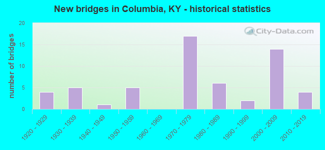
- New bridges - historical statistics
- 41920-1929
- 51930-1939
- 11940-1949
- 51950-1959
- 171970-1979
- 61980-1989
- 21990-1999
- 142000-2009
- 42010-2019

- Reconstructed bridges - Historical Statistics
- 21960-1969
- 01970-1979
- 01980-1989
- 01990-1999
- 02000-2009
- 12010-2019


- Bridge Condition - Deck
- 5.3%Very good
- 39.5%Good
- 39.5%Satisfactory
- 13.2%Fair
- 2.6%Poor

- Bridge Condition - Superstructure
- 13.2%Very good
- 31.6%Good
- 39.5%Satisfactory
- 15.8%Fair

- Bridge Condition - Substructure
- 2.6%Very good
- 44.7%Good
- 36.8%Satisfactory
- 15.8%Fair

- Bridge Condition - Channel
- 2.4%Excellent
- 21.4%Very good
- 38.1%Good
- 21.4%Satisfactory
- 11.9%Fair
- 4.8%Poor

- Bridge Condition - Culverts
- 8.3%Very good
- 8.3%Good
- 66.7%Satisfactory
- 16.7%Poor
Find on map >> Show street view
Structure Number: 1C00056N, Location: 136' E. OF JCT KY 1323 (Lat: 37.117500, Lng: -85.270278), Route carried "on" structure: County highway 1422, Year Built: 2003, Status: Posted for load, Structure Length: 1.52m (4.99ft), Average Daily Traffic: 29 (year 2019), Average Future Daily Traffic: 25 (year 2039), Features Intersected: HUTICHISON BRANCH, Facility Carried by Structure: DWIGHT CURRY RD
Minimum Vertical Clearance: 30+ m (98+ ft), Kilometerpoint: 0.043, Lanes on structure: 1, Owner: County Highway Agency, Approaching Roadway Width: 3.4m (11.2ft), Skew: 3 degrees, Material/Design: Steel continuous, Design/Construction: Stringer/Multi-beam, Number Of Spans In Main Unit: 2, Length of Maximum Span: 6.7m (22.0ft), Curb or Sidewalk Widths: Left: 0.2m (0.7ft), Right: 0.2m (0.7ft), Curb-To-Curb Width: 4.8m (15.7ft), Out-to-Out Width: 5.2m (17.1ft)
Condition: Deck: Satisfactory, Superstructure: Satisfactory, Substructure: Fair, Channel: Satisfactory, Operating Rating: 20.7 metric tons, Method Used To Determine Operating Rating: Load Factor (LF), Inventory Rating: 12.4 metric tons, Method Used To Determine Inventory Rating: Load Factor (LF), Structural Evaluation: Meets minimum limits, Deck Geometry: Equal to present desirable criteria, Waterway Adequacy: Equal to present minimum criteria, Approach Roadway Alignment: Equal to present desirable criteria, Bridge Posting: Required (Relationship of Operating Rating to Maximum Legal Load: > 39.9% below), Designated Inspection Frequency: Every 12 months, Inspection Date: September 2021, Deck Structure Type: Concrete Cast-file-Place, Wearing Surface/Protective System: Wearing Surface: Monolithic Concrete
Find on map >> Show street view
Structure Number: 1C00061N, Location: 0.192 MI. SW. KY 633 (Lat: 37.184722, Lng: -85.335833), Route carried "on" structure: County highway 1445, Year Built: 2003, Status: Posted for load, Structure Length: 0.76m (2.49ft), Average Daily Traffic: 76 (year 2019), Average Future Daily Traffic: 66 (year 2039), Features Intersected: CANEY FORK CREEK, Facility Carried by Structure: C R JONES RD
Minimum Vertical Clearance: 30+ m (98+ ft), Kilometerpoint: 0.322, Lanes on structure: 2, Owner: County Highway Agency, Approaching Roadway Width: 3.8m (12.5ft), Material/Design: Steel, Design/Construction: Stringer/Multi-beam, Number Of Spans In Main Unit: 1, Length of Maximum Span: 7.0m (23.0ft), Curb or Sidewalk Widths: Left: 0.3m (1.0ft), Right: 0.3m (1.0ft), Curb-To-Curb Width: 5.6m (18.4ft), Out-to-Out Width: 6.1m (20.0ft)
Condition: Deck: Satisfactory, Superstructure: Satisfactory, Substructure: Satisfactory, Channel: Fair, Operating Rating: 11.3 metric tons, Method Used To Determine Operating Rating: Load Factor (LF), Inventory Rating: 6.8 metric tons, Method Used To Determine Inventory Rating: Load Factor (LF), Structural Evaluation: High priority of corrective action, Deck Geometry: Meets minimum limits, Waterway Adequacy: Equal to present minimum criteria, Approach Roadway Alignment: Equal to present desirable criteria, Bridge Posting: Required (Relationship of Operating Rating to Maximum Legal Load: > 39.9% below), Designated Inspection Frequency: Every 12 months, Inspection Date: September 2021, Deck Structure Type: Concrete Cast-file-Place, Wearing Surface/Protective System: Wearing Surface: Bituminous
Find on map >> Show street view
Structure Number: 1C00070N, Location: .086 MI. W. JCT CR 5033 (Lat: 37.192222, Lng: -85.076111), Route carried "on" structure: County highway 1031, Year Built: 2007, Status: Open, Structure Length: 0.91m (2.99ft), Average Daily Traffic: 113 (year 2019), Average Future Daily Traffic: 98 (year 2039), Features Intersected: SHORT CREEK, Facility Carried by Structure: DUNVILLE RD
Minimum Vertical Clearance: 30+ m (98+ ft), Kilometerpoint: 4.633, Lanes on structure: 2, Owner: County Highway Agency, Approaching Roadway Width: 4.9m (16.1ft), Material/Design: Prestressed concrete, Design/Construction: Box Beam or Girders - Multiple, Number Of Spans In Main Unit: 1, Length of Maximum Span: 8.2m (26.9ft), Curb or Sidewalk Widths: Left: 0.2m (0.7ft), Right: 0.2m (0.7ft), Curb-To-Curb Width: 7.1m (23.3ft), Out-to-Out Width: 7.3m (24.0ft)
Condition: Deck: Good, Superstructure: Good, Substructure: Satisfactory, Channel: Satisfactory, Operating Rating: 93.4 metric tons, Method Used To Determine Operating Rating: Load Factor (LF), Inventory Rating: 56.1 metric tons, Method Used To Determine Inventory Rating: Load Factor (LF), Structural Evaluation: Equal to present minimum criteria, Deck Geometry: Meets minimum limits, Waterway Adequacy: Better than present minimum criteria, Approach Roadway Alignment: Equal to present desirable criteria, Designated Inspection Frequency: Every 24 months, Inspection Date: September 2021, Deck Structure Type: Concrete Precast Panels, Wearing Surface/Protective System: Wearing Surface: Bituminous
Find on map >> Show street view
Structure Number: 1C00072N, Location: .830 MI JCT KY 61 (Lat: 37.085556, Lng: -85.320000), Route carried "on" structure: City street 1067, Year Built: 1927, Status: Open, Structure Length: 4.88m (16.01ft), Average Daily Traffic: 48 (year 2019), Average Future Daily Traffic: 41 (year 2039), Design Load: H 15, Features Intersected: Petty's Fork, Facility Carried by Structure: BURKESVILLE LOOP
Minimum Vertical Clearance: 30+ m (98+ ft), Kilometerpoint: 1.395, Lanes on structure: 2, Owner: City or Municipal Highway Agency, Approaching Roadway Width: 7.3m (24.0ft), Material/Design: Concrete, Design/Construction: Tee Beam, Number Of Spans In Main Unit: 4, Length of Maximum Span: 12.2m (40.0ft), Curb or Sidewalk Widths: Left: 0.5m (1.6ft), Right: 0.5m (1.6ft), Curb-To-Curb Width: 5.8m (19.0ft), Out-to-Out Width: 6.7m (22.0ft)
Condition: Deck: Satisfactory, Superstructure: Satisfactory, Substructure: Fair, Channel: Excellent, Operating Rating: 55.7 metric tons, Method Used To Determine Operating Rating: Load Factor (LF), Inventory Rating: 33.5 metric tons, Method Used To Determine Inventory Rating: Load Factor (LF), Structural Evaluation: Somewhat better than minimum adequacy, Deck Geometry: Meets minimum limits, Waterway Adequacy: Equal to present desirable criteria, Approach Roadway Alignment: Equal to present desirable criteria, Designated Inspection Frequency: Every 24 months, Inspection Date: September 2021, Deck Structure Type: Concrete Cast-file-Place, Wearing Surface/Protective System: Wearing Surface: Latex Concrete
Find on map >> Show street view
Structure Number: 1C00074N, Location: 0.3 MI. E OF JCT KY 61 (Lat: 37.049722, Lng: -85.357500), Route carried "on" structure: County highway 1289, Year Built: 2010, Status: Open, Structure Length: 1.89m (6.20ft), Average Daily Traffic: 38 (year 2019), Average Future Daily Traffic: 33 (year 2039), Design Load: HS 25 or greater, Features Intersected: BRUSH CREEK, Facility Carried by Structure: LASLEY RD
Minimum Vertical Clearance: 30.18m (99.02ft), Kilometerpoint: 0.373, Lanes on structure: 2, Owner: County Highway Agency, Approaching Roadway Width: 7.3m (24.0ft), Skew: 3 degrees, Material/Design: Prestressed concrete, Design/Construction: Box Beam or Girders - Single/Spread, Number Of Spans In Main Unit: 1, Length of Maximum Span: 17.8m (58.4ft), Curb or Sidewalk Widths: Left: 0.2m (0.7ft), Right: 0.2m (0.7ft), Curb-To-Curb Width: 6.7m (22.0ft), Out-to-Out Width: 7.2m (23.6ft)
Condition: Deck: Good, Superstructure: Good, Substructure: Good, Channel: Good, Operating Rating: 98.0 metric tons, Method Used To Determine Operating Rating: Load Factor (LF), Inventory Rating: 58.8 metric tons, Method Used To Determine Inventory Rating: Load Factor (LF), Structural Evaluation: Better than present minimum criteria, Deck Geometry: Somewhat better than minimum adequacy, Waterway Adequacy: Somewhat better than minimum adequacy, Approach Roadway Alignment: Equal to present desirable criteria, Designated Inspection Frequency: Every 24 months, Inspection Date: September 2021, Deck Structure Type: Concrete Cast-file-Place, Wearing Surface/Protective System: Wearing Surface: Monolithic Concrete, Deck Protection: Epoxy Coated Reinforcing
Find on map >> Show street view
Structure Number: 1C00075N, Location: 0.840 MI. E. OF JCT KY 55 (Lat: 37.081667, Lng: -85.285278), Route carried "on" structure: County highway 1145, Year Built: 2008, Status: Posted for load, Structure Length: 1.22m (4.00ft), Average Daily Traffic: 50 (year 2011), Average Future Daily Traffic: 50 (year 2031), Features Intersected: TRIB. OF RUSSELL CREEK, Facility Carried by Structure: CREEK BEND RD
Minimum Vertical Clearance: 30+ m (98+ ft), Kilometerpoint: 1.390, Lanes on structure: 2, Owner: County Highway Agency, Approaching Roadway Width: 4.9m (16.1ft), Skew: 4 degrees, Material/Design: Steel, Design/Construction: Stringer/Multi-beam, Number Of Spans In Main Unit: 1, Length of Maximum Span: 10.7m (35.1ft), Curb or Sidewalk Widths: Left: 0.3m (1.0ft), Right: 0.3m (1.0ft), Curb-To-Curb Width: 6.8m (22.3ft), Out-to-Out Width: 6.8m (22.3ft)
Condition: Deck: Good, Superstructure: Satisfactory, Substructure: Fair, Channel: Satisfactory, Operating Rating: 51.2 metric tons, Method Used To Determine Operating Rating: Load Factor (LF), Inventory Rating: 30.8 metric tons, Method Used To Determine Inventory Rating: Load Factor (LF), Structural Evaluation: Somewhat better than minimum adequacy, Deck Geometry: Somewhat better than minimum adequacy, Waterway Adequacy: Equal to present minimum criteria, Approach Roadway Alignment: Better than present minimum criteria, Bridge Posting: Required (Relationship of Operating Rating to Maximum Legal Load: 10.0 - 19.9% below), Designated Inspection Frequency: Every 24 months, Inspection Date: September 2021, Deck Structure Type: Concrete Cast-file-Place, Wearing Surface/Protective System: Wearing Surface: Bituminous
Find on map >> Show street view
Structure Number: 1C00082N, Location: 1.5 Mi N of Jct KY 768 (Lat: 37.040000, Lng: -85.369167), Route carried "on" structure: County highway 1995, Year Built: 1928, Status: Posted for load, Structure Length: 0.94m (3.08ft), Average Daily Traffic: 231 (year 2015), Average Future Daily Traffic: 281 (year 2035), Design Load: H 15, Features Intersected: Brush Creek, Facility Carried by Structure: Old KY-61
Minimum Vertical Clearance: 30.18m (99.02ft), Kilometerpoint: 3.693, Lanes on structure: 2, Owner: County Highway Agency, Approaching Roadway Width: 5.5m (18.0ft), Material/Design: Concrete, Design/Construction: Tee Beam, Number Of Spans In Main Unit: 1, Length of Maximum Span: 8.5m (27.9ft), Curb or Sidewalk Widths: Left: 0.5m (1.6ft), Right: 0.5m (1.6ft), Curb-To-Curb Width: 5.8m (19.0ft), Out-to-Out Width: 6.1m (20.0ft)
Condition: Deck: Satisfactory, Superstructure: Fair, Substructure: Satisfactory, Channel: Good, Operating Rating: 49.7 metric tons, Method Used To Determine Operating Rating: Load Factor (LF), Inventory Rating: 29.8 metric tons, Method Used To Determine Inventory Rating: Load Factor (LF), Structural Evaluation: Somewhat better than minimum adequacy, Deck Geometry: High priority of corrective action, Waterway Adequacy: Superior to present desirable criteria, Approach Roadway Alignment: Equal to present desirable criteria, Bridge Posting: Required (Relationship of Operating Rating to Maximum Legal Load: 20.0 - 29.9% below), Designated Inspection Frequency: Every 24 months, Inspection Date: September 2021, Deck Structure Type: Concrete Cast-file-Place, Wearing Surface/Protective System: Wearing Surface: Bituminous
Find on map >> Show street view
Structure Number: 1C00086N, Location: .5 MI FROM CR 1175 (Lat: 37.035278, Lng: -85.334722), Route carried "on" structure: County highway 1361, Year Built: 2019, Status: Open, Structure Length: 1.62m (5.31ft), Average Daily Traffic: 10 (year 2019), Average Future Daily Traffic: 8 (year 2039), Features Intersected: Pettys Fork, Facility Carried by Structure: Rollin Coomer Rd
Minimum Vertical Clearance: 30+ m (98+ ft), Kilometerpoint: 0.016, Lanes on structure: 2, Owner: County Highway Agency, Approaching Roadway Width: 3.7m (12.1ft), Material/Design: Steel, Design/Construction: Stringer/Multi-beam, Number Of Spans In Main Unit: 1, Length of Maximum Span: 15.2m (49.9ft), Curb or Sidewalk Widths: Left: 0.3m (1.0ft), Right: 0.3m (1.0ft), Curb-To-Curb Width: 6.1m (20.0ft), Out-to-Out Width: 6.6m (21.7ft)
Condition: Deck: Very good, Superstructure: Good, Substructure: Very good, Channel: Good, Operating Rating: 99.8 metric tons, Method Used To Determine Operating Rating: Load Factor (LF), Inventory Rating: 76.5 metric tons, Method Used To Determine Inventory Rating: Load Factor (LF), Structural Evaluation: Better than present minimum criteria, Deck Geometry: Somewhat better than minimum adequacy, Waterway Adequacy: Better than present minimum criteria, Approach Roadway Alignment: Equal to present minimum criteria, Designated Inspection Frequency: Every 24 months, Inspection Date: September 2021, Deck Structure Type: Concrete Cast-file-Place, Wearing Surface/Protective System: Wearing Surface: Monolithic Concrete
Find on map >> Show street view
Structure Number: 1B00061N, Location: 3.5 MI W OF KY 55 NTRCH (Lat: 37.073056, Lng: -85.363889), Route carried "under" structure: County highway 1324, Year Built: 1972, Structure Length: 0. m, Average Daily Traffic: 119 (year 2006), Features Intersected: BLISS ROAD, Facility Carried by Structure: LN-9008
Minimum Vertical Clearance: 4.50m (14.76ft), Kilometerpoint: 0.592, Lanes on structure: 4, Lanes under structure: 2, Material/Design: Concrete, Design/Construction: Culvert, Length of Maximum Span: 7.7m (25.3ft)
Find on map >> Show street view
Structure Number: 1B00064N, Location: 1.4 MI E OF KY 55 NTRCH (Lat: 37.089167, Lng: -85.278056), Route carried "under" structure: County highway 1169, Year Built: 1971, Structure Length: 0. m, Average Daily Traffic: 291 (year 2018), Features Intersected: Conover RD, Facility Carried by Structure: LN-9008
Minimum Vertical Clearance: 4.50m (14.76ft), Kilometerpoint: 0.098, Lanes on structure: 4, Lanes under structure: 2, Material/Design: Concrete, Design/Construction: Culvert, Length of Maximum Span: 7.3m (24.0ft)
Find on map >> Show street view
Structure Number: 1B00065N, Location: .1 MI S OF JCT KY 80 (Lat: 37.087222, Lng: -85.266111), Route carried "under" structure: State highway 9008, Year Built: 1972, Structure Length: 0. m, Average Daily Traffic: 6,909 (year 2020), Truck Traffic: 21%, Features Intersected: LN-9008, Facility Carried by Structure: SAWMILL RD CR1845
Minimum Vertical Clearance: 5.82m (19.09ft), Kilometerpoint: 82.106, Lanes on structure: 2, Lanes under structure: 4, Material/Design: Concrete continuous, Design/Construction: Tee Beam, Length of Maximum Span: 19.2m (63.0ft)
Find on map >> Show street view
Structure Number: 1B00066N, Location: 3.6 MI E OF KY 55 NTRCH (Lat: 37.078889, Lng: -85.239444), Route carried "under" structure: County highway 1150, Year Built: 1971, Structure Length: 0. m, Average Daily Traffic: 86 (year 2020), Features Intersected: ARNOLD KEENE WILSON ROAD, Facility Carried by Structure: LN-9008
Minimum Vertical Clearance: 4.50m (14.76ft), Kilometerpoint: 0.323, Lanes on structure: 4, Lanes under structure: 2, Material/Design: Concrete, Design/Construction: Culvert, Length of Maximum Span: 7.9m (25.9ft)
Find on map >> Show street view
Structure Number: 1B00067N, Location: 4.0 MI EAST OF KY 55 NTRC (Lat: 37.075556, Lng: -85.229722), Route carried "under" structure: Bypass County highway 1846, Year Built: 1972, Structure Length: 0. m, Average Daily Traffic: 38 (year 2019), Features Intersected: SHILOH ROAD, Facility Carried by Structure: LN-9008
Minimum Vertical Clearance: 4.50m (14.76ft), Kilometerpoint: 0.301, Lanes on structure: 4, Lanes under structure: 2, Material/Design: Concrete, Design/Construction: Culvert, Length of Maximum Span: 7.3m (24.0ft)
Find on map >> Show street view
Structure Number: 1B00083N, Location: 0.21 MILES SOUTH OF KY 80 (Lat: 37.073056, Lng: -85.339444), Route carried "under" structure: State highway 9008, Year Built: 2007, Structure Length: 0. m, Average Daily Traffic: 7,445 (year 2020), Truck Traffic: 21%, Features Intersected: LN 9008 (CUMB PKWY), Facility Carried by Structure: KY 61
Minimum Vertical Clearance: 5.89m (19.32ft), Kilometerpoint: 75.036, Lanes on structure: 2, Lanes under structure: 4, Material/Design: Prestressed concrete continuous, Design/Construction: Stringer/Multi-beam, Length of Maximum Span: 34.7m (113.8ft)
Find on map >> Show street view
Structure Number: 1B00085N, Location: 0.481 MI. S. OF JCT KY 61 (Lat: 37.084444, Lng: -85.312222), Route carried "under" structure: State highway 9008, Year Built: 2008, Structure Length: 0. m, Average Daily Traffic: 7,445 (year 2020), Truck Traffic: 21%, Features Intersected: LN 9008, Facility Carried by Structure: KY-55
Minimum Vertical Clearance: 5.43m (17.81ft), Kilometerpoint: 77.809, Lanes on structure: 2, Lanes under structure: 4, Material/Design: Prestressed concrete continuous, Design/Construction: Stringer/Multi-beam, Length of Maximum Span: 34.1m (111.9ft)
Find on map >> Show street view
Structure Number: 1B00086N, Location: 303' S. OF JCT KY 439 (Lat: 37.100278, Lng: -85.331389), Route carried "under" structure: State highway 2287, Year Built: 2008, Structure Length: 0. m, Average Daily Traffic: 1,948 (year 2018), Truck Traffic: 10%, Features Intersected: KY 439 ,KY 61, Facility Carried by Structure: KY 55
Minimum Vertical Clearance: 4.88m (16.01ft), Kilometerpoint: 2.692, Lanes on structure: 2, Lanes under structure: 2, Material/Design: Prestressed concrete continuous, Design/Construction: Stringer/Multi-beam, Length of Maximum Span: 24.4m (80.1ft)