Bridge Statistics for Conroe, Texas (TX)
Condition, Traffic, Stress, Structural Evaluation, Project Costs
- National Bridge Inventory (NBI) Statistics
- 202Number of bridges
- 5,177ft / 1,578mTotal length
- $1,153,000Total costs
- 4,634,990Total average daily traffic
- 504,720Total average daily truck traffic
- National Bridge Inventory (NBI) Registered Bridges for Conroe
- No street view available for this location
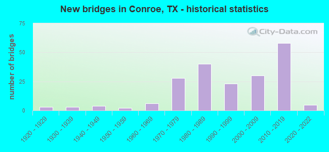
- New bridges - historical statistics
- 31920-1929
- 31930-1939
- 41940-1949
- 21950-1959
- 61960-1969
- 281970-1979
- 401980-1989
- 231990-1999
- 302000-2009
- 582010-2019
- 52020-2022
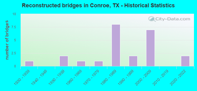
- Reconstructed bridges - Historical Statistics
- 11930-1939
- 01940-1949
- 21950-1959
- 11960-1969
- 11970-1979
- 81980-1989
- 21990-1999
- 72000-2009
- 02010-2019
- 22020-2022
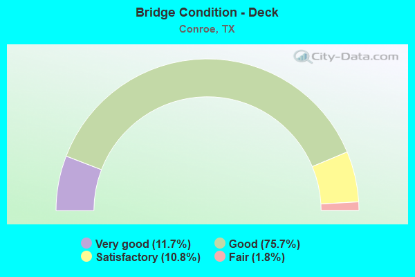
- Bridge Condition - Deck
- 11.7%Very good
- 75.7%Good
- 10.8%Satisfactory
- 1.8%Fair
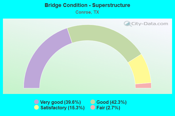
- Bridge Condition - Superstructure
- 39.6%Very good
- 42.3%Good
- 15.3%Satisfactory
- 2.7%Fair
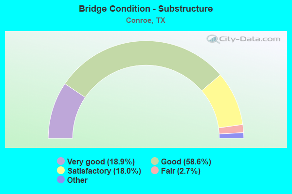
- Bridge Condition - Substructure
- 18.9%Excellent
- 58.6%Very good
- 18.0%Good
- 2.7%Satisfactory
- 1.8%Fair
- 0.9%Poor
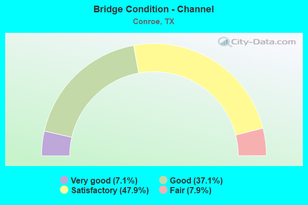
- Bridge Condition - Channel
- 7.1%Very good
- 37.1%Good
- 47.9%Satisfactory
- 7.9%Fair
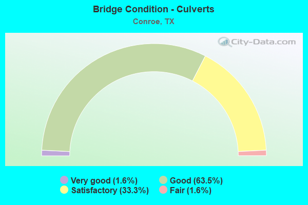
- Bridge Condition - Culverts
- 1.6%Very good
- 63.5%Good
- 33.3%Satisfactory
- 1.6%Fair
Find on map >> Show street view
Structure Number: 121700011003006, Location: 0.45 MI S OF FM 830 (Lat: 30.383939, Lng: -95.478214), Route carried "on" structure: State highway 75, Year Built: 1926, Year Reconstructed: 1936, Status: Open, Structure Length: 1.68m (5.51ft), Average Daily Traffic: 8,006 (year 2020), Truck Traffic: 6%, Average Future Daily Traffic: 16,540 (year 2033), Features Intersected: STEWARTS CREEK
Minimum Vertical Clearance: 30+ m (98+ ft), Kilometerpoint: 6.210, Lanes on structure: 2, Owner: State Highway Agency, Approaching Roadway Width: 9.8m (32.2ft), Material/Design: Concrete, Design/Construction: Culvert, Number Of Spans In Main Unit: 6, Length of Maximum Span: 2.4m (7.9ft), Curb-To-Curb Width: 16.5m (54.1ft), Out-to-Out Width: 17.5m (57.4ft)
Condition: Channel: Good, Culverts: Satisfactory, Operating Rating: 39.9 metric tons, Method Used To Determine Operating Rating: Load Factor (LF), Inventory Rating: 23.6 metric tons, Method Used To Determine Inventory Rating: Load Factor (LF), Structural Evaluation: Somewhat better than minimum adequacy, Deck Geometry: Superior to present desirable criteria, Waterway Adequacy: Equal to present minimum criteria, Approach Roadway Alignment: Equal to present desirable criteria, Designated Inspection Frequency: Every 24 months, Inspection Date: October 2020, Deck Structure Type: Concrete Cast-file-Place, Wearing Surface/Protective System: Wearing Surface: Bituminous
Find on map >> Show street view
Structure Number: 121700011003007, Location: 0.15 MI N OF FM 3083 (Lat: 30.351953, Lng: -95.472108), Route carried "on" structure: State highway 75, Year Built: 1926, Year Reconstructed: 1987, Status: Open, Structure Length: 0.82m (2.69ft), Average Daily Traffic: 11,507 (year 2020), Truck Traffic: 6%, Average Future Daily Traffic: 18,900 (year 2033), Design Load: H 15, Features Intersected: CRYSTAL CREEK
Minimum Vertical Clearance: 30+ m (98+ ft), Kilometerpoint: 9.854, Lanes on structure: 2, Owner: State Highway Agency, Approaching Roadway Width: 11.0m (36.1ft), Skew: 9 degrees, Material/Design: Concrete, Design/Construction: Culvert, Number Of Spans In Main Unit: 4, Length of Maximum Span: 1.8m (5.9ft)
Condition: Channel: Satisfactory, Culverts: Good, Operating Rating: 39.9 metric tons, Method Used To Determine Operating Rating: Load Factor (LF), Inventory Rating: 23.6 metric tons, Method Used To Determine Inventory Rating: Load Factor (LF), Structural Evaluation: Somewhat better than minimum adequacy, Waterway Adequacy: Equal to present minimum criteria, Approach Roadway Alignment: Equal to present desirable criteria, Designated Inspection Frequency: Every 24 months, Inspection Date: October 2020
Find on map >> Show street view
Structure Number: 121700011003008, Location: 1.10 MI S OF LP 336 (Lat: 30.320289, Lng: -95.464436), Route carried "on" structure: State highway 75, Year Built: 1926, Year Reconstructed: 1958, Status: Open, Structure Length: 1.71m (5.61ft), Average Daily Traffic: 14,915 (year 2020), Truck Traffic: 6%, Average Future Daily Traffic: 19,960 (year 2033), Features Intersected: LAKE CREEK
Minimum Vertical Clearance: 30+ m (98+ ft), Kilometerpoint: 13.477, Lanes on structure: 5, Owner: State Highway Agency, Approaching Roadway Width: 19.5m (64.0ft), Material/Design: Concrete, Design/Construction: Culvert, Number Of Spans In Main Unit: 8, Length of Maximum Span: 1.8m (5.9ft), Curb or Sidewalk Widths: Left: 3.0m (9.8ft), Right: 3.0m (9.8ft), Curb-To-Curb Width: 19.6m (64.3ft), Out-to-Out Width: 26.3m (86.3ft)
Condition: Channel: Satisfactory, Culverts: Good, Operating Rating: 39.9 metric tons, Method Used To Determine Operating Rating: Load Factor (LF), Inventory Rating: 23.6 metric tons, Method Used To Determine Inventory Rating: Load Factor (LF), Structural Evaluation: Somewhat better than minimum adequacy, Deck Geometry: Meets minimum limits, Waterway Adequacy: Equal to present minimum criteria, Approach Roadway Alignment: Equal to present desirable criteria, Designated Inspection Frequency: Every 24 months, Inspection Date: October 2020, Deck Structure Type: Concrete Cast-file-Place, Wearing Surface/Protective System: Wearing Surface: Bituminous
Find on map >> Show street view
Structure Number: 121700011003034, Location: 0.4 MI N OF FM 830 (Lat: 30.397022, Lng: -95.474089), Route carried "on" structure: State highway 75, Year Built: 1941, Status: Open, Structure Length: 0.94m (3.08ft), Average Daily Traffic: 9,237 (year 2020), Truck Traffic: 6%, Average Future Daily Traffic: 16,540 (year 2033), Design Load: H 15, Features Intersected: E FORK CRYSTAL CREEK
Minimum Vertical Clearance: 30+ m (98+ ft), Kilometerpoint: 4.722, Lanes on structure: 2, Owner: State Highway Agency, Approaching Roadway Width: 10.4m (34.1ft), Material/Design: Concrete, Design/Construction: Culvert, Number Of Spans In Main Unit: 4, Length of Maximum Span: 2.1m (6.9ft), Curb-To-Curb Width: 12.8m (42.0ft), Out-to-Out Width: 14.2m (46.6ft)
Condition: Channel: Satisfactory, Culverts: Fair, Operating Rating: 39.9 metric tons, Method Used To Determine Operating Rating: Load Factor (LF), Inventory Rating: 23.6 metric tons, Method Used To Determine Inventory Rating: Load Factor (LF), Structural Evaluation: Somewhat better than minimum adequacy, Deck Geometry: Somewhat better than minimum adequacy, Waterway Adequacy: Equal to present minimum criteria, Approach Roadway Alignment: Equal to present desirable criteria, Designated Inspection Frequency: Every 24 months, Inspection Date: October 2020, Deck Structure Type: Concrete Cast-file-Place, Wearing Surface/Protective System: Wearing Surface: Bituminous
Find on map >> Show street view
Structure Number: 121700011004134, Location: 2.1 MI S OF FM 1488 (Lat: 30.207161, Lng: -95.456111), Route carried "on" structure: Interstate 45, Year Built: 1991, Status: Open, Structure Length: 10.67m (35.01ft), Average Daily Traffic: 89,494 (year 2017), Truck Traffic: 8%, Average Future Daily Traffic: 110,840 (year 2033), Features Intersected: SH 242
Minimum Vertical Clearance: 30+ m (98+ ft), Kilometerpoint: 10.926, Lanes on structure: 4, Lanes under structure: 10, Owner: State Highway Agency, Approaching Roadway Width: 21.3m (69.9ft), Material/Design: Prestressed concrete, Design/Construction: Stringer/Multi-beam, Number Of Spans In Main Unit: 4, Length of Maximum Span: 27.4m (89.9ft), Curb-To-Curb Width: 21.3m (69.9ft), Out-to-Out Width: 22.2m (72.8ft)
Condition: Deck: Good, Superstructure: Fair, Substructure: Good, Operating Rating: 68.0 metric tons, Method Used To Determine Operating Rating: Load Factor (LF), Inventory Rating: 32.7 metric tons, Method Used To Determine Inventory Rating: Load Factor (LF), Structural Evaluation: Somewhat better than minimum adequacy, Deck Geometry: Better than present minimum criteria, Underclear: Meets minimum limits, Approach Roadway Alignment: Equal to present desirable criteria, Designated Inspection Frequency: Every 24 months, Inspection Date: August 2020, Deck Structure Type: Concrete Cast-file-Place
Find on map >> Show street view
Structure Number: 12170001100414, Location: 2.00 MI N OF SH 242 (Lat: 30.236617, Lng: -95.458789), Route carried "on" structure: State highway 1488, Year Built: 1994, Status: Open, Structure Length: 14.26m (46.78ft), Average Daily Traffic: 40,520 (year 2013), Truck Traffic: 9%, Average Future Daily Traffic: 56,730 (year 2033), Design Load: HS 20, Features Intersected: IH 45
Minimum Vertical Clearance: 30+ m (98+ ft), Kilometerpoint: 37.556, Lanes on structure: 4, Lanes under structure: 16, Owner: State Highway Agency, Approaching Roadway Width: 21.9m (71.9ft), Material/Design: Prestressed concrete, Design/Construction: Stringer/Multi-beam, Number Of Spans In Main Unit: 4, Length of Maximum Span: 35.7m (117.1ft), Curb-To-Curb Width: 21.9m (71.9ft), Out-to-Out Width: 22.8m (74.8ft)
Condition: Deck: Good, Superstructure: Good, Substructure: Fair, Operating Rating: 54.4 metric tons, Method Used To Determine Operating Rating: Assigned rating based on Load Factor Design (LFD) reported in metric tons, Inventory Rating: 32.7 metric tons, Method Used To Determine Inventory Rating: Assigned rating based on Load Factor Design (LFD) reported in metric tons, Structural Evaluation: Somewhat better than minimum adequacy, Deck Geometry: Superior to present desirable criteria, Underclear: Meets minimum limits, Approach Roadway Alignment: Equal to present desirable criteria, Designated Inspection Frequency: Every 24 months, Inspection Date: August 2020, Deck Structure Type: Concrete Precast Panels
Find on map >> Show street view
Structure Number: 121700011004165, Location: 0.90 MI N OF FM 1488 (Lat: 30.249558, Lng: -95.457331), Route carried "on" structure: ServiceInterstate 45, Year Built: 1997, Status: Open, Structure Length: 20.33m (66.70ft), Average Daily Traffic: 2,540 (year 2013), Truck Traffic: 8%, Average Future Daily Traffic: 3,560 (year 2033), Design Load: HS 20, Features Intersected: W FK SAN JAC RI N REL
Minimum Vertical Clearance: 30+ m (98+ ft), Kilometerpoint: 15.722, Lanes on structure: 3, Owner: State Highway Agency, Approaching Roadway Width: 12.2m (40.0ft), Material/Design: Prestressed concrete, Design/Construction: Stringer/Multi-beam, Number Of Spans In Main Unit: 11, Length of Maximum Span: 18.6m (61.0ft), Curb-To-Curb Width: 12.2m (40.0ft), Out-to-Out Width: 13.0m (42.7ft)
Condition: Deck: Good, Superstructure: Good, Substructure: Good, Channel: Good, Operating Rating: 54.4 metric tons, Method Used To Determine Operating Rating: Assigned rating based on Load Factor Design (LFD) reported in metric tons, Inventory Rating: 32.7 metric tons, Method Used To Determine Inventory Rating: Assigned rating based on Load Factor Design (LFD) reported in metric tons, Structural Evaluation: Better than present minimum criteria, Deck Geometry: Meets minimum limits, Waterway Adequacy: Superior to present desirable criteria, Approach Roadway Alignment: Equal to present desirable criteria, Length Of Structure Improvement: 20.33m (66.70ft), Designated Inspection Frequency: Every 24 months, Inspection Date: August 2020, Bridge Improvement Cost: $53,000, Roadway Improvement Cost: $13,000, Total Project Cost: $66,000, Deck Structure Type: Concrete Cast-file-Place
Find on map >> Show street view
Structure Number: 121700011004166, Location: 0.65 MI N OF FM 1488 (Lat: 30.245994, Lng: -95.457722), Route carried "on" structure: ServiceInterstate 45, Year Built: 1997, Status: Open, Structure Length: 33.53m (110.01ft), Average Daily Traffic: 2,778 (year 2018), Truck Traffic: 8%, Average Future Daily Traffic: 3,560 (year 2033), Design Load: HS 20, Features Intersected: W FK SAN JACINTO RIVER
Minimum Vertical Clearance: 30+ m (98+ ft), Kilometerpoint: 14.981, Lanes on structure: 3, Lanes under structure: 2, Owner: State Highway Agency, Approaching Roadway Width: 12.2m (40.0ft), Material/Design: Steel continuous, Design/Construction: Stringer/Multi-beam, Number Of Spans In Main Unit: 3, Number Of Approach Spans: 11, Length of Maximum Span: 49.7m (163.1ft), Curb-To-Curb Width: 12.2m (40.0ft), Out-to-Out Width: 13.0m (42.7ft)
Condition: Deck: Good, Superstructure: Good, Substructure: Good, Channel: Fair, Operating Rating: 65.3 metric tons, Method Used To Determine Operating Rating: Load Factor (LF), Inventory Rating: 38.1 metric tons, Method Used To Determine Inventory Rating: Load Factor (LF), Structural Evaluation: Better than present minimum criteria, Deck Geometry: Meets minimum limits, Waterway Adequacy: Superior to present desirable criteria, Approach Roadway Alignment: Equal to present desirable criteria, Designated Inspection Frequency: Every 24 months, Inspection Date: August 2020, Deck Structure Type: Concrete Cast-file-Place
Find on map >> Show street view
Structure Number: 121700011004167, Location: 0.20 MI N OF FM 1488 (Lat: 30.239461, Lng: -95.459033), Route carried "on" structure: ServiceInterstate 45, Year Built: 1997, Status: Open, Structure Length: 7.41m (24.31ft), Average Daily Traffic: 2,540 (year 2013), Truck Traffic: 8%, Average Future Daily Traffic: 3,560 (year 2033), Design Load: HS 20, Features Intersected: W FK SAN JACINTO S REL
Minimum Vertical Clearance: 30+ m (98+ ft), Kilometerpoint: 14.510, Lanes on structure: 3, Owner: State Highway Agency, Approaching Roadway Width: 12.2m (40.0ft), Material/Design: Prestressed concrete, Design/Construction: Stringer/Multi-beam, Number Of Spans In Main Unit: 4, Length of Maximum Span: 18.3m (60.0ft), Curb-To-Curb Width: 12.2m (40.0ft), Out-to-Out Width: 13.0m (42.7ft)
Condition: Deck: Very good, Superstructure: Very good, Substructure: Good, Channel: Very good, Operating Rating: 54.4 metric tons, Method Used To Determine Operating Rating: Assigned rating based on Load Factor Design (LFD) reported in metric tons, Inventory Rating: 32.7 metric tons, Method Used To Determine Inventory Rating: Assigned rating based on Load Factor Design (LFD) reported in metric tons, Structural Evaluation: Better than present minimum criteria, Deck Geometry: Meets minimum limits, Waterway Adequacy: Superior to present desirable criteria, Approach Roadway Alignment: Equal to present desirable criteria, Length Of Structure Improvement: 7.41m (24.31ft), Designated Inspection Frequency: Every 24 months, Inspection Date: September 2020, Bridge Improvement Cost: $19,000, Roadway Improvement Cost: $5,000, Total Project Cost: $24,000, Deck Structure Type: Concrete Precast Panels
Find on map >> Show street view
Structure Number: 121700011004168, Location: 0.90 MI N OF FM 1488 (Lat: 30.251242, Lng: -95.456475), Route carried "on" structure: ServiceInterstate 45, Year Built: 1997, Status: Open, Structure Length: 20.33m (66.70ft), Average Daily Traffic: 3,990 (year 2013), Truck Traffic: 8%, Average Future Daily Traffic: 5,590 (year 2033), Design Load: HS 20, Features Intersected: W FK SAN JAC RI N REL
Minimum Vertical Clearance: 30+ m (98+ ft), Kilometerpoint: 15.702, Lanes on structure: 3, Owner: State Highway Agency, Approaching Roadway Width: 12.2m (40.0ft), Material/Design: Prestressed concrete, Design/Construction: Stringer/Multi-beam, Number Of Spans In Main Unit: 11, Length of Maximum Span: 18.6m (61.0ft), Curb-To-Curb Width: 12.2m (40.0ft), Out-to-Out Width: 13.0m (42.7ft)
Condition: Deck: Good, Superstructure: Very good, Substructure: Good, Channel: Satisfactory, Operating Rating: 54.4 metric tons, Method Used To Determine Operating Rating: Assigned rating based on Load Factor Design (LFD) reported in metric tons, Inventory Rating: 32.7 metric tons, Method Used To Determine Inventory Rating: Assigned rating based on Load Factor Design (LFD) reported in metric tons, Structural Evaluation: Better than present minimum criteria, Deck Geometry: Meets minimum limits, Waterway Adequacy: Superior to present desirable criteria, Approach Roadway Alignment: Equal to present desirable criteria, Length Of Structure Improvement: 20.33m (66.70ft), Designated Inspection Frequency: Every 24 months, Inspection Date: August 2020, Bridge Improvement Cost: $53,000, Roadway Improvement Cost: $13,000, Total Project Cost: $66,000, Deck Structure Type: Concrete Cast-file-Place
Find on map >> Show street view
Structure Number: 121700011004169, Location: 0.65 MI N OF FM 1488 (Lat: 30.242881, Lng: -95.457428), Route carried "on" structure: ServiceInterstate 45, Year Built: 1997, Status: Open, Structure Length: 33.53m (110.01ft), Average Daily Traffic: 3,836 (year 2018), Truck Traffic: 9%, Average Future Daily Traffic: 5,590 (year 2033), Design Load: HS 20, Features Intersected: W FK SAN JACINTO RIVER
Minimum Vertical Clearance: 30+ m (98+ ft), Kilometerpoint: 14.981, Lanes on structure: 3, Lanes under structure: 2, Owner: State Highway Agency, Approaching Roadway Width: 12.2m (40.0ft), Material/Design: Steel continuous, Design/Construction: Stringer/Multi-beam, Number Of Spans In Main Unit: 3, Number Of Approach Spans: 11, Length of Maximum Span: 47.2m (154.9ft), Curb-To-Curb Width: 12.2m (40.0ft), Out-to-Out Width: 13.0m (42.7ft)
Condition: Deck: Good, Superstructure: Good, Substructure: Good, Channel: Satisfactory, Operating Rating: 65.3 metric tons, Method Used To Determine Operating Rating: Load Factor (LF), Inventory Rating: 38.1 metric tons, Method Used To Determine Inventory Rating: Load Factor (LF), Structural Evaluation: Better than present minimum criteria, Deck Geometry: Meets minimum limits, Waterway Adequacy: Superior to present desirable criteria, Approach Roadway Alignment: Equal to present desirable criteria, Length Of Structure Improvement: 34.08m (111.81ft), Designated Inspection Frequency: Every 24 months, Inspection Date: August 2020, Bridge Improvement Cost: $89,000, Roadway Improvement Cost: $22,000, Total Project Cost: $111,000, Deck Structure Type: Concrete Cast-file-Place
Find on map >> Show street view
Structure Number: 12170001100417, Location: 0.20 MI N OF FM 1488 (Lat: 30.239394, Lng: -95.457953), Route carried "on" structure: ServiceInterstate 45, Year Built: 1997, Status: Open, Structure Length: 7.41m (24.31ft), Average Daily Traffic: 3,990 (year 2013), Truck Traffic: 8%, Average Future Daily Traffic: 5,590 (year 2033), Design Load: HS 20, Features Intersected: W FK SAN JACINTO S REL
Minimum Vertical Clearance: 30+ m (98+ ft), Kilometerpoint: 14.510, Lanes on structure: 3, Owner: State Highway Agency, Approaching Roadway Width: 12.2m (40.0ft), Material/Design: Prestressed concrete, Design/Construction: Stringer/Multi-beam, Number Of Spans In Main Unit: 4, Length of Maximum Span: 18.3m (60.0ft), Curb-To-Curb Width: 12.2m (40.0ft), Out-to-Out Width: 13.0m (42.7ft)
Condition: Deck: Very good, Superstructure: Very good, Substructure: Good, Channel: Very good, Operating Rating: 54.4 metric tons, Method Used To Determine Operating Rating: Assigned rating based on Load Factor Design (LFD) reported in metric tons, Inventory Rating: 32.7 metric tons, Method Used To Determine Inventory Rating: Assigned rating based on Load Factor Design (LFD) reported in metric tons, Structural Evaluation: Better than present minimum criteria, Deck Geometry: Meets minimum limits, Waterway Adequacy: Superior to present desirable criteria, Approach Roadway Alignment: Equal to present desirable criteria, Length Of Structure Improvement: 7.41m (24.31ft), Designated Inspection Frequency: Every 24 months, Inspection Date: September 2020, Bridge Improvement Cost: $19,000, Roadway Improvement Cost: $5,000, Total Project Cost: $24,000, Deck Structure Type: Concrete Precast Panels
Find on map >> Show street view
Structure Number: 121700011004171, Location: 0.20 MI S OF SH 242 (Lat: 30.204731, Lng: -95.455967), Route carried "on" structure: Interstate 45, Year Built: 1990, Status: Open, Structure Length: 1.49m (4.89ft), Average Daily Traffic: 163,343 (year 2020), Truck Traffic: 8%, Average Future Daily Traffic: 221,690 (year 2033), Design Load: HS 20, Features Intersected: HARPERS HORSEPEN BR
Minimum Vertical Clearance: 30+ m (98+ ft), Kilometerpoint: 10.610, Lanes on structure: 16, Owner: State Highway Agency, Approaching Roadway Width: 71.9m (235.9ft), Skew: 30 degrees, Material/Design: Concrete, Design/Construction: Culvert, Number Of Spans In Main Unit: 5, Length of Maximum Span: 2.4m (7.9ft)
Condition: Channel: Good, Culverts: Good, Operating Rating: 39.9 metric tons, Method Used To Determine Operating Rating: Load Factor (LF), Inventory Rating: 23.6 metric tons, Method Used To Determine Inventory Rating: Load Factor (LF), Structural Evaluation: Somewhat better than minimum adequacy, Waterway Adequacy: Equal to present minimum criteria, Approach Roadway Alignment: Equal to present desirable criteria, Designated Inspection Frequency: Every 24 months, Inspection Date: August 2020
Find on map >> Show street view
Structure Number: 121700011004183, Location: 1.35 MI N OF FM 1488 (Lat: 30.255833, Lng: -95.456617), Route carried "on" structure: Interstate 45, Year Built: 2007, Status: Open, Structure Length: 6.40m (21.00ft), Average Daily Traffic: 156,512 (year 2020), Truck Traffic: 8%, Average Future Daily Traffic: 194,350 (year 2033), Design Load: HS 20, Features Intersected: RIVER PLANTATION DR
Minimum Vertical Clearance: 30+ m (98+ ft), Kilometerpoint: 16.388, Lanes on structure: 9, Lanes under structure: 6, Owner: State Highway Agency, Approaching Roadway Width: 49.4m (162.1ft), Skew: 30 degrees, Material/Design: Prestressed concrete, Design/Construction: Stringer/Multi-beam, Number Of Spans In Main Unit: 1, Number Of Approach Spans: 2, Length of Maximum Span: 30.5m (100.1ft), Curb-To-Curb Width: 53.2m (174.5ft), Out-to-Out Width: 54.8m (179.8ft)
Condition: Deck: Good, Superstructure: Very good, Substructure: Good, Operating Rating: 54.4 metric tons, Method Used To Determine Operating Rating: Assigned rating based on Load Factor Design (LFD) reported in metric tons, Inventory Rating: 32.7 metric tons, Method Used To Determine Inventory Rating: Assigned rating based on Load Factor Design (LFD) reported in metric tons, Structural Evaluation: Better than present minimum criteria, Deck Geometry: Superior to present desirable criteria, Underclear: Equal to present minimum criteria, Approach Roadway Alignment: Equal to present desirable criteria, Designated Inspection Frequency: Every 24 months, Inspection Date: October 2020, Deck Structure Type: Concrete Cast-file-Place
Find on map >> Show street view
Structure Number: 121700011004184, Location: 0.90 MI N OF FM 1488 (Lat: 30.249500, Lng: -95.456664), Route carried "on" structure: Interstate 45, Year Built: 2007, Status: Open, Structure Length: 21.09m (69.19ft), Average Daily Traffic: 156,512 (year 2020), Truck Traffic: 8%, Average Future Daily Traffic: 194,350 (year 2033), Design Load: HS 20, Features Intersected: W FK SAN JAC RI N REL
Minimum Vertical Clearance: 30+ m (98+ ft), Kilometerpoint: 15.704, Lanes on structure: 10, Owner: State Highway Agency, Approaching Roadway Width: 49.4m (162.1ft), Skew: 39 degrees, Material/Design: Prestressed concrete, Design/Construction: Stringer/Multi-beam, Number Of Spans In Main Unit: 10, Number Of Approach Spans: 2, Length of Maximum Span: 18.6m (61.0ft), Curb-To-Curb Width: 49.6m (162.7ft), Out-to-Out Width: 51.1m (167.7ft)
Condition: Deck: Good, Superstructure: Good, Substructure: Good, Channel: Good, Operating Rating: 54.4 metric tons, Method Used To Determine Operating Rating: Assigned rating based on Load Factor Design (LFD) reported in metric tons, Inventory Rating: 32.7 metric tons, Method Used To Determine Inventory Rating: Assigned rating based on Load Factor Design (LFD) reported in metric tons, Structural Evaluation: Better than present minimum criteria, Deck Geometry: Superior to present desirable criteria, Waterway Adequacy: Superior to present desirable criteria, Approach Roadway Alignment: Equal to present desirable criteria, Designated Inspection Frequency: Every 24 months, Inspection Date: August 2020, Deck Structure Type: Concrete Cast-file-Place
Find on map >> Show street view
Structure Number: 121700011004185, Location: 0.44 MI N OF FM 1488 (Lat: 30.242967, Lng: -95.457728), Route carried "on" structure: Interstate 45, Year Built: 2007, Status: Open, Structure Length: 33.68m (110.50ft), Average Daily Traffic: 156,512 (year 2020), Truck Traffic: 8%, Average Future Daily Traffic: 194,350 (year 2033), Design Load: HS 20, Features Intersected: W FK SAN JACINTO RI
Minimum Vertical Clearance: 30+ m (98+ ft), Kilometerpoint: 14.980, Lanes on structure: 10, Owner: State Highway Agency, Approaching Roadway Width: 50.0m (164.0ft), Skew: 30 degrees, Material/Design: Steel continuous, Design/Construction: Stringer/Multi-beam, Number Of Spans In Main Unit: 3, Number Of Approach Spans: 4, Length of Maximum Span: 71.9m (235.9ft), Curb-To-Curb Width: 50.2m (164.7ft), Out-to-Out Width: 51.1m (167.7ft)
Condition: Deck: Good, Superstructure: Good, Substructure: Good, Channel: Satisfactory, Operating Rating: 54.4 metric tons, Method Used To Determine Operating Rating: Assigned rating based on Load Factor Design (LFD) reported in metric tons, Inventory Rating: 32.7 metric tons, Method Used To Determine Inventory Rating: Assigned rating based on Load Factor Design (LFD) reported in metric tons, Structural Evaluation: Better than present minimum criteria, Deck Geometry: Superior to present desirable criteria, Waterway Adequacy: Superior to present desirable criteria, Approach Roadway Alignment: Equal to present desirable criteria, Designated Inspection Frequency: Every 24 months, Inspection Date: September 2020, Deck Structure Type: Concrete Cast-file-Place
Find on map >> Show street view
Structure Number: 121700011004186, Location: 0.15 MI N OF FM 1488 (Lat: 30.238747, Lng: -95.458267), Route carried "on" structure: Interstate 45, Year Built: 2007, Status: Open, Structure Length: 7.38m (24.21ft), Average Daily Traffic: 156,512 (year 2020), Truck Traffic: 8%, Average Future Daily Traffic: 194,350 (year 2033), Design Load: HS 20, Features Intersected: W FK SAN JAC RI S REL
Minimum Vertical Clearance: 30+ m (98+ ft), Kilometerpoint: 14.510, Lanes on structure: 10, Owner: State Highway Agency, Approaching Roadway Width: 49.7m (163.1ft), Skew: 30 degrees, Material/Design: Prestressed concrete, Design/Construction: Stringer/Multi-beam, Number Of Spans In Main Unit: 4, Length of Maximum Span: 18.3m (60.0ft), Curb-To-Curb Width: 49.6m (162.7ft), Out-to-Out Width: 51.1m (167.7ft)
Condition: Deck: Very good, Superstructure: Very good, Substructure: Good, Channel: Good, Operating Rating: 54.4 metric tons, Method Used To Determine Operating Rating: Assigned rating based on Load Factor Design (LFD) reported in metric tons, Inventory Rating: 32.7 metric tons, Method Used To Determine Inventory Rating: Assigned rating based on Load Factor Design (LFD) reported in metric tons, Structural Evaluation: Better than present minimum criteria, Deck Geometry: Superior to present desirable criteria, Waterway Adequacy: Superior to present desirable criteria, Approach Roadway Alignment: Equal to present desirable criteria, Designated Inspection Frequency: Every 24 months, Inspection Date: September 2020, Deck Structure Type: Concrete Precast Panels
Find on map >> Show street view
Structure Number: 121700011004191, Location: 2.1 MI S OF FM 1488 (Lat: 30.206969, Lng: -95.455917), Route carried "on" structure: Ramp Interstate 45, Year Built: 2000, Status: Open, Structure Length: 10.67m (35.01ft), Average Daily Traffic: 15,830 (year 2013), Truck Traffic: 8%, Average Future Daily Traffic: 22,160 (year 2033), Design Load: HS 20, Features Intersected: SH 242
Minimum Vertical Clearance: 30+ m (98+ ft), Kilometerpoint: 11.026, Lanes on structure: 1, Lanes under structure: 10, Owner: State Highway Agency, Approaching Roadway Width: 6.1m (20.0ft), Material/Design: Prestressed concrete, Design/Construction: Stringer/Multi-beam, Number Of Spans In Main Unit: 4, Length of Maximum Span: 27.4m (89.9ft), Curb-To-Curb Width: 6.2m (20.3ft), Out-to-Out Width: 6.7m (22.0ft)
Condition: Deck: Very good, Superstructure: Very good, Substructure: Good, Operating Rating: 54.4 metric tons, Method Used To Determine Operating Rating: Assigned rating based on Load Factor Design (LFD) reported in metric tons, Inventory Rating: 32.7 metric tons, Method Used To Determine Inventory Rating: Assigned rating based on Load Factor Design (LFD) reported in metric tons, Structural Evaluation: Better than present minimum criteria, Deck Geometry: Somewhat better than minimum adequacy, Underclear: Meets minimum limits, Approach Roadway Alignment: Equal to present desirable criteria, Length Of Structure Improvement: 10.67m (35.01ft), Designated Inspection Frequency: Every 24 months, Inspection Date: August 2020, Bridge Improvement Cost: $144,000, Roadway Improvement Cost: $36,000, Total Project Cost: $180,000, Deck Structure Type: Concrete Cast-file-Place
Find on map >> Show street view
Structure Number: 121700011004202, Location: 2.00 MI N OF FM 1488 (Lat: 30.264958, Lng: -95.456564), Route carried "on" structure: Interstate 45, Year Built: 2007, Status: Open, Structure Length: 10.97m (35.99ft), Average Daily Traffic: 156,512 (year 2020), Truck Traffic: 8%, Average Future Daily Traffic: 194,350 (year 2033), Design Load: HS 20, Features Intersected: CRIGHTON RD
Minimum Vertical Clearance: 30+ m (98+ ft), Kilometerpoint: 17.429, Lanes on structure: 8, Lanes under structure: 5, Owner: State Highway Agency, Approaching Roadway Width: 49.4m (162.1ft), Skew: 30 degrees, Material/Design: Prestressed concrete, Design/Construction: Stringer/Multi-beam, Number Of Spans In Main Unit: 3, Length of Maximum Span: 36.6m (120.1ft), Curb-To-Curb Width: 49.6m (162.7ft), Out-to-Out Width: 51.1m (167.7ft)
Condition: Deck: Very good, Superstructure: Good, Substructure: Good, Operating Rating: 54.4 metric tons, Method Used To Determine Operating Rating: Assigned rating based on Load Factor Design (LFD) reported in metric tons, Inventory Rating: 32.7 metric tons, Method Used To Determine Inventory Rating: Assigned rating based on Load Factor Design (LFD) reported in metric tons, Structural Evaluation: Better than present minimum criteria, Deck Geometry: Superior to present desirable criteria, Underclear: Better than present minimum criteria, Approach Roadway Alignment: Equal to present desirable criteria, Designated Inspection Frequency: Every 24 months, Inspection Date: September 2020, Deck Structure Type: Concrete Precast Panels
Find on map >> Show street view
Structure Number: 121700011004203, Location: 0.30 MI S OF S LP 336 (Lat: 30.275489, Lng: -95.456739), Route carried "on" structure: Interstate 45, Year Built: 2007, Status: Open, Structure Length: 1.10m (3.61ft), Average Daily Traffic: 156,512 (year 2020), Truck Traffic: 8%, Average Future Daily Traffic: 194,350 (year 2033), Design Load: HS 20, Features Intersected: SILVERDALE CRK
Minimum Vertical Clearance: 30+ m (98+ ft), Kilometerpoint: 18.578, Lanes on structure: 14, Owner: State Highway Agency, Approaching Roadway Width: 75.0m (246.1ft), Skew: 31 degrees, Material/Design: Concrete, Design/Construction: Culvert, Number Of Spans In Main Unit: 3, Length of Maximum Span: 3.0m (9.8ft), Curb or Sidewalk Widths: Left: 1.8m (5.9ft), Right: 1.8m (5.9ft)
Condition: Channel: Satisfactory, Culverts: Good, Operating Rating: 54.4 metric tons, Method Used To Determine Operating Rating: Assigned rating based on Load Factor Design (LFD) reported in metric tons, Inventory Rating: 32.7 metric tons, Method Used To Determine Inventory Rating: Assigned rating based on Load Factor Design (LFD) reported in metric tons, Structural Evaluation: Better than present minimum criteria, Waterway Adequacy: Equal to present minimum criteria, Approach Roadway Alignment: Equal to present desirable criteria, Designated Inspection Frequency: Every 24 months, Inspection Date: August 2020
Find on map >> Show street view
Structure Number: 121700011004204, Location: 2.05 MI N OF FM 1488 (Lat: 30.266372, Lng: -95.456292), Route carried "on" structure: Interstate 45, Year Built: 2007, Status: Open, Structure Length: 1.34m (4.40ft), Average Daily Traffic: 156,512 (year 2020), Truck Traffic: 8%, Average Future Daily Traffic: 194,350 (year 2033), Design Load: HS 20, Features Intersected: DRAW
Minimum Vertical Clearance: 30+ m (98+ ft), Kilometerpoint: 17.593, Lanes on structure: 14, Owner: State Highway Agency, Approaching Roadway Width: 73.2m (240.2ft), Skew: 30 degrees, Material/Design: Concrete, Design/Construction: Culvert, Number Of Spans In Main Unit: 4, Length of Maximum Span: 2.7m (8.9ft), Curb or Sidewalk Widths: Left: 1.8m (5.9ft), Right: 1.8m (5.9ft)
Condition: Channel: Good, Culverts: Good, Operating Rating: 54.4 metric tons, Method Used To Determine Operating Rating: Assigned rating based on Load Factor Design (LFD) reported in metric tons, Inventory Rating: 32.7 metric tons, Method Used To Determine Inventory Rating: Assigned rating based on Load Factor Design (LFD) reported in metric tons, Structural Evaluation: Better than present minimum criteria, Waterway Adequacy: Superior to present desirable criteria, Approach Roadway Alignment: Equal to present desirable criteria, Designated Inspection Frequency: Every 24 months, Inspection Date: August 2020
Find on map >> Show street view
Structure Number: 121700011004308, Location: 0.4 MI S of SH 242 (Lat: 30.204525, Lng: -95.455536), Route carried "on" structure: Ramp Interstate 45, Year Built: 2014, Status: Open, Structure Length: 45.42m (149.02ft), Average Daily Traffic: 4,650 (year 2018), Truck Traffic: 10%, Average Future Daily Traffic: 1 (year 1900), Design Load: HL 93, Features Intersected: R.O.W
Minimum Vertical Clearance: 30+ m (98+ ft), Kilometerpoint: 0.000, Lanes on structure: 1, Toll: On toll road, Owner: State Highway Agency, Approaching Roadway Width: 8.5m (27.9ft), Material/Design: Prestressed concrete, Design/Construction: Stringer/Multi-beam, Number Of Spans In Main Unit: 13, Length of Maximum Span: 35.1m (115.2ft), Curb-To-Curb Width: 11.0m (36.1ft), Out-to-Out Width: 11.7m (38.4ft)
Condition: Deck: Good, Superstructure: Very good, Substructure: Good, Operating Rating: 54.4 metric tons, Method Used To Determine Operating Rating: Assigned ratings based on Load and Resistance Factor Design (LRFD) reported in metric tons, Inventory Rating: 32.7 metric tons, Method Used To Determine Inventory Rating: Assigned ratings based on Load and Resistance Factor Design (LRFD) reported in metric tons, Structural Evaluation: Better than present minimum criteria, Deck Geometry: Superior to present desirable criteria, Approach Roadway Alignment: Equal to present desirable criteria, Designated Inspection Frequency: Every 24 months, Inspection Date: December 2020, Deck Structure Type: Concrete Cast-file-Place
Find on map >> Show street view
Structure Number: 121700033803075, Location: 0.2 MI E OF IH 45 (Lat: 30.313894, Lng: -95.468983), Route carried "on" structure: State highway 105, Year Built: 1947, Year Reconstructed: 1990, Status: Open, Structure Length: 3.05m (10.01ft), Average Daily Traffic: 25,447 (year 2020), Truck Traffic: 13%, Average Future Daily Traffic: 32,280 (year 2033), Design Load: H 20, Features Intersected: ALLIGATOR CRK
Minimum Vertical Clearance: 30+ m (98+ ft), Kilometerpoint: 35.544, Lanes on structure: 7, Owner: State Highway Agency, Approaching Roadway Width: 30.8m (101.0ft), Material/Design: Concrete, Design/Construction: Slab, Number Of Spans In Main Unit: 5, Length of Maximum Span: 6.1m (20.0ft), Curb or Sidewalk Widths: Left: 1.3m (4.3ft), Right: 1.3m (4.3ft), Curb-To-Curb Width: 30.8m (101.0ft), Out-to-Out Width: 34.7m (113.8ft)
Condition: Deck: Good, Superstructure: Good, Substructure: Satisfactory, Channel: Satisfactory, Operating Rating: 52.6 metric tons, Method Used To Determine Operating Rating: Load Factor (LF), Inventory Rating: 31.7 metric tons, Method Used To Determine Inventory Rating: Load Factor (LF), Structural Evaluation: Equal to present minimum criteria, Deck Geometry: Better than present minimum criteria, Waterway Adequacy: Superior to present desirable criteria, Approach Roadway Alignment: Equal to present desirable criteria, Designated Inspection Frequency: Every 24 months, Inspection Date: September 2020, Deck Structure Type: Concrete Cast-file-Place, Wearing Surface/Protective System: Wearing Surface: Bituminous
Find on map >> Show street view
Structure Number: 12170003380309, Location: 0.25 MI SE OF LP 336 (Lat: 30.323856, Lng: -95.492383), Route carried "on" structure: State highway 105, Year Built: 1947, Year Reconstructed: 1968, Status: Open, Structure Length: 1.19m (3.90ft), Average Daily Traffic: 35,731 (year 2020), Truck Traffic: 13%, Average Future Daily Traffic: 27,470 (year 2033), Design Load: H 15, Features Intersected: DRAW
Minimum Vertical Clearance: 30+ m (98+ ft), Kilometerpoint: 33.054, Lanes on structure: 5, Owner: State Highway Agency, Approaching Roadway Width: 24.4m (80.1ft), Skew: 9 degrees, Material/Design: Concrete, Design/Construction: Culvert, Number Of Spans In Main Unit: 4, Length of Maximum Span: 3.7m (12.1ft), Curb-To-Curb Width: 24.7m (81.0ft), Out-to-Out Width: 25.6m (84.0ft)
Condition: Channel: Satisfactory, Culverts: Satisfactory, Operating Rating: 39.9 metric tons, Method Used To Determine Operating Rating: Load Factor (LF), Inventory Rating: 23.6 metric tons, Method Used To Determine Inventory Rating: Load Factor (LF), Structural Evaluation: Somewhat better than minimum adequacy, Deck Geometry: Superior to present desirable criteria, Waterway Adequacy: Equal to present minimum criteria, Approach Roadway Alignment: Equal to present desirable criteria, Designated Inspection Frequency: Every 24 months, Inspection Date: September 2020, Deck Structure Type: Concrete Cast-file-Place, Wearing Surface/Protective System: Wearing Surface: Bituminous
Find on map >> Show street view
Structure Number: 121700033803097, Location: 3.70 MI E OF FM 149 (Lat: 30.374056, Lng: -95.636300), Route carried "on" structure: State highway 105, Year Built: 1972, Year Reconstructed: 1994, Status: Open, Structure Length: 3.66m (12.01ft), Average Daily Traffic: 34,381 (year 2020), Truck Traffic: 13%, Average Future Daily Traffic: 44,650 (year 2033), Features Intersected: MARTIN CREEK
Minimum Vertical Clearance: 30+ m (98+ ft), Kilometerpoint: 17.875, Lanes on structure: 7, Owner: State Highway Agency, Approaching Roadway Width: 32.9m (107.9ft), Material/Design: Concrete, Design/Construction: Stringer/Multi-beam, Number Of Spans In Main Unit: 3, Length of Maximum Span: 12.2m (40.0ft), Curb-To-Curb Width: 32.9m (107.9ft), Out-to-Out Width: 33.8m (110.9ft)
Condition: Deck: Satisfactory, Superstructure: Good, Substructure: Satisfactory, Channel: Satisfactory, Operating Rating: 32.7 metric tons, Method Used To Determine Operating Rating: Field evaluation and documented engineering judgment, Inventory Rating: 24.5 metric tons, Method Used To Determine Inventory Rating: Field evaluation and documented engineering judgment, Structural Evaluation: Equal to present minimum criteria, Deck Geometry: Superior to present desirable criteria, Waterway Adequacy: Superior to present desirable criteria, Approach Roadway Alignment: Equal to present desirable criteria, Designated Inspection Frequency: Every 24 months, Underwater Inspection Frequency: Every 60 months, Inspection Date: September 2020, Underwater Inspection Date: July 2017, Deck Structure Type: Concrete Cast-file-Place
Find on map >> Show street view
Structure Number: 121700033803098, Location: 4.40 MI SE OF FM 149 (Lat: 30.370644, Lng: -95.628942), Route carried "on" structure: State highway 105, Year Built: 1972, Year Reconstructed: 1994, Status: Open, Structure Length: 3.08m (10.10ft), Average Daily Traffic: 34,381 (year 2020), Truck Traffic: 13%, Average Future Daily Traffic: 44,650 (year 2033), Features Intersected: LAKE CONROE
Minimum Vertical Clearance: 30+ m (98+ ft), Kilometerpoint: 18.697, Lanes on structure: 7, Owner: State Highway Agency, Approaching Roadway Width: 32.9m (107.9ft), Material/Design: Concrete, Design/Construction: Stringer/Multi-beam, Number Of Spans In Main Unit: 3, Length of Maximum Span: 12.2m (40.0ft), Curb-To-Curb Width: 32.9m (107.9ft), Out-to-Out Width: 33.8m (110.9ft)
Condition: Deck: Good, Superstructure: Satisfactory, Substructure: Satisfactory, Channel: Good, Operating Rating: 32.7 metric tons, Method Used To Determine Operating Rating: Field evaluation and documented engineering judgment, Inventory Rating: 24.5 metric tons, Method Used To Determine Inventory Rating: Field evaluation and documented engineering judgment, Structural Evaluation: Equal to present minimum criteria, Deck Geometry: Superior to present desirable criteria, Waterway Adequacy: Superior to present desirable criteria, Approach Roadway Alignment: Equal to present desirable criteria, Designated Inspection Frequency: Every 24 months, Underwater Inspection Frequency: Every 60 months, Inspection Date: August 2020, Underwater Inspection Date: July 2017, Deck Structure Type: Concrete Cast-file-Place
Find on map >> Show street view
Structure Number: 121700033803099, Location: 6.10 MI E OF FM 149 (Lat: 30.359517, Lng: -95.598775), Route carried "on" structure: State highway 105, Year Built: 1972, Year Reconstructed: 1994, Status: Open, Structure Length: 3.08m (10.10ft), Average Daily Traffic: 34,381 (year 2020), Truck Traffic: 13%, Average Future Daily Traffic: 44,650 (year 2033), Features Intersected: RUSH CREEK
Minimum Vertical Clearance: 30+ m (98+ ft), Kilometerpoint: 21.821, Lanes on structure: 7, Owner: State Highway Agency, Approaching Roadway Width: 32.9m (107.9ft), Material/Design: Concrete, Design/Construction: Stringer/Multi-beam, Number Of Spans In Main Unit: 3, Length of Maximum Span: 12.2m (40.0ft), Curb-To-Curb Width: 32.9m (107.9ft), Out-to-Out Width: 33.8m (110.9ft)
Condition: Deck: Good, Superstructure: Good, Substructure: Satisfactory, Channel: Satisfactory, Operating Rating: 32.7 metric tons, Method Used To Determine Operating Rating: Field evaluation and documented engineering judgment, Inventory Rating: 24.5 metric tons, Method Used To Determine Inventory Rating: Field evaluation and documented engineering judgment, Structural Evaluation: Equal to present minimum criteria, Deck Geometry: Superior to present desirable criteria, Waterway Adequacy: Superior to present desirable criteria, Approach Roadway Alignment: Equal to present desirable criteria, Designated Inspection Frequency: Every 24 months, Underwater Inspection Frequency: Every 60 months, Inspection Date: August 2020, Underwater Inspection Date: July 2017, Deck Structure Type: Concrete Cast-file-Place
Find on map >> Show street view
Structure Number: 1217000338031, Location: 6.50 MI SE OF FM 149 (Lat: 30.358669, Lng: -95.596411), Route carried "on" structure: State highway 105, Year Built: 1972, Year Reconstructed: 1994, Status: Open, Structure Length: 3.08m (10.10ft), Average Daily Traffic: 34,381 (year 2020), Truck Traffic: 13%, Average Future Daily Traffic: 44,650 (year 2033), Features Intersected: LAKE CONROE CREEK
Minimum Vertical Clearance: 30+ m (98+ ft), Kilometerpoint: 22.067, Lanes on structure: 7, Owner: State Highway Agency, Approaching Roadway Width: 32.9m (107.9ft), Material/Design: Concrete, Design/Construction: Stringer/Multi-beam, Number Of Spans In Main Unit: 3, Length of Maximum Span: 12.2m (40.0ft), Curb-To-Curb Width: 32.9m (107.9ft), Out-to-Out Width: 33.8m (110.9ft)
Condition: Deck: Good, Superstructure: Good, Substructure: Satisfactory, Channel: Satisfactory, Operating Rating: 32.7 metric tons, Method Used To Determine Operating Rating: Field evaluation and documented engineering judgment, Inventory Rating: 24.5 metric tons, Method Used To Determine Inventory Rating: Field evaluation and documented engineering judgment, Structural Evaluation: Equal to present minimum criteria, Deck Geometry: Superior to present desirable criteria, Waterway Adequacy: Superior to present desirable criteria, Approach Roadway Alignment: Equal to present desirable criteria, Designated Inspection Frequency: Every 24 months, Inspection Date: August 2020, Deck Structure Type: Concrete Cast-file-Place
Find on map >> Show street view
Structure Number: 1217000338032, Location: 3.80 MI NW OF LP 336 (Lat: 30.343697, Lng: -95.554214), Route carried "on" structure: State highway 105, Year Built: 1994, Status: Open, Structure Length: 3.47m (11.38ft), Average Daily Traffic: 39,416 (year 2020), Truck Traffic: 6%, Average Future Daily Traffic: 45,960 (year 2033), Design Load: HS 20, Features Intersected: BASE CREEK
Minimum Vertical Clearance: 30+ m (98+ ft), Kilometerpoint: 26.479, Lanes on structure: 7, Owner: State Highway Agency, Approaching Roadway Width: 32.9m (107.9ft), Material/Design: Prestressed concrete, Design/Construction: Box Beam or Girders - Multiple, Number Of Spans In Main Unit: 1, Number Of Approach Spans: 2, Length of Maximum Span: 15.2m (49.9ft), Curb-To-Curb Width: 32.9m (107.9ft), Out-to-Out Width: 33.8m (110.9ft)
Condition: Deck: Good, Superstructure: Good, Substructure: Good, Channel: Satisfactory, Operating Rating: 54.4 metric tons, Method Used To Determine Operating Rating: Assigned rating based on Load Factor Design (LFD) reported in metric tons, Inventory Rating: 32.7 metric tons, Method Used To Determine Inventory Rating: Assigned rating based on Load Factor Design (LFD) reported in metric tons, Structural Evaluation: Better than present minimum criteria, Deck Geometry: Superior to present desirable criteria, Waterway Adequacy: Equal to present desirable criteria, Approach Roadway Alignment: Equal to present desirable criteria, Designated Inspection Frequency: Every 24 months, Inspection Date: August 2020, Deck Structure Type: Concrete Precast Panels
Find on map >> Show street view
Structure Number: 121700033803201, Location: 3.10 MI NW OF LP 336 (Lat: 30.342411, Lng: -95.541258), Route carried "on" structure: State highway 105, Year Built: 1994, Status: Open, Structure Length: 50.75m (166.50ft), Average Daily Traffic: 39,416 (year 2020), Truck Traffic: 6%, Average Future Daily Traffic: 45,960 (year 2033), Design Load: HS 20, Features Intersected: WEST SAN JACINTO RIVER
Minimum Vertical Clearance: 30+ m (98+ ft), Kilometerpoint: 27.500, Lanes on structure: 7, Owner: State Highway Agency, Approaching Roadway Width: 32.9m (107.9ft), Material/Design: Prestressed concrete, Design/Construction: Stringer/Multi-beam, Number Of Spans In Main Unit: 1, Number Of Approach Spans: 20, Length of Maximum Span: 35.1m (115.2ft), Curb-To-Curb Width: 32.9m (107.9ft), Out-to-Out Width: 33.8m (110.9ft)
Condition: Deck: Good, Superstructure: Very good, Substructure: Good, Channel: Satisfactory, Operating Rating: 54.4 metric tons, Method Used To Determine Operating Rating: Assigned rating based on Load Factor Design (LFD) reported in metric tons, Inventory Rating: 32.7 metric tons, Method Used To Determine Inventory Rating: Assigned rating based on Load Factor Design (LFD) reported in metric tons, Structural Evaluation: Better than present minimum criteria, Deck Geometry: Superior to present desirable criteria, Waterway Adequacy: Superior to present desirable criteria, Approach Roadway Alignment: Equal to present desirable criteria, Designated Inspection Frequency: Every 24 months, Inspection Date: September 2020, Deck Structure Type: Concrete Cast-file-Place
Find on map >> Show street view
Structure Number: 121700033803202, Location: 0.20 MI NW OF LP 336 (Lat: 30.327806, Lng: -95.501306), Route carried "on" structure: State highway 105, Year Built: 1994, Status: Open, Structure Length: 5.03m (16.50ft), Average Daily Traffic: 35,731 (year 2020), Truck Traffic: 13%, Average Future Daily Traffic: 43,160 (year 2033), Design Load: HS 20, Features Intersected: WHITE OAK CREEK
Minimum Vertical Clearance: 30+ m (98+ ft), Kilometerpoint: 32.082, Lanes on structure: 7, Owner: State Highway Agency, Approaching Roadway Width: 32.9m (107.9ft), Material/Design: Prestressed concrete, Design/Construction: Stringer/Multi-beam, Number Of Spans In Main Unit: 3, Length of Maximum Span: 19.8m (65.0ft), Curb-To-Curb Width: 32.9m (107.9ft), Out-to-Out Width: 33.8m (110.9ft)
Condition: Deck: Good, Superstructure: Very good, Substructure: Good, Channel: Satisfactory, Operating Rating: 54.4 metric tons, Method Used To Determine Operating Rating: Assigned rating based on Load Factor Design (LFD) reported in metric tons, Inventory Rating: 32.7 metric tons, Method Used To Determine Inventory Rating: Assigned rating based on Load Factor Design (LFD) reported in metric tons, Structural Evaluation: Better than present minimum criteria, Deck Geometry: Superior to present desirable criteria, Waterway Adequacy: Superior to present desirable criteria, Approach Roadway Alignment: Equal to present desirable criteria, Designated Inspection Frequency: Every 24 months, Inspection Date: September 2020, Deck Structure Type: Concrete Cast-file-Place
Find on map >> Show street view
Structure Number: 121700033803203, Location: 2.45 MI NW OF LP 336 (Lat: 30.342569, Lng: -95.531833), Route carried "on" structure: State highway 105, Year Built: 1994, Status: Open, Structure Length: 1.07m (3.51ft), Average Daily Traffic: 39,416 (year 2020), Truck Traffic: 6%, Average Future Daily Traffic: 45,960 (year 2033), Design Load: HS 20, Features Intersected: OUTFALL CHANNEL
Minimum Vertical Clearance: 30+ m (98+ ft), Kilometerpoint: 28.685, Lanes on structure: 7, Owner: State Highway Agency, Approaching Roadway Width: 32.9m (107.9ft), Material/Design: Concrete, Design/Construction: Culvert, Number Of Spans In Main Unit: 4, Length of Maximum Span: 2.1m (6.9ft)
Condition: Channel: Satisfactory, Culverts: Good, Operating Rating: 44.4 metric tons, Method Used To Determine Operating Rating: Field evaluation and documented engineering judgment, Inventory Rating: 24.5 metric tons, Method Used To Determine Inventory Rating: Field evaluation and documented engineering judgment, Structural Evaluation: Equal to present minimum criteria, Waterway Adequacy: Equal to present minimum criteria, Approach Roadway Alignment: Equal to present desirable criteria, Designated Inspection Frequency: Every 24 months, Inspection Date: September 2020
Find on map >> Show street view
Structure Number: 121700033804054, Location: 2.00 MI E OF IH 45 (Lat: 30.316244, Lng: -95.440167), Route carried "on" structure: State highway 105, Year Built: 1936, Year Reconstructed: 1981, Status: Open, Structure Length: 3.66m (12.01ft), Average Daily Traffic: 19,778 (year 2020), Truck Traffic: 13%, Average Future Daily Traffic: 22,790 (year 2033), Design Load: H 15, Features Intersected: STEWARTS CREEK
Minimum Vertical Clearance: 30+ m (98+ ft), Kilometerpoint: 38.431, Lanes on structure: 5, Owner: State Highway Agency, Approaching Roadway Width: 19.5m (64.0ft), Material/Design: Concrete, Design/Construction: Tee Beam, Number Of Spans In Main Unit: 4, Length of Maximum Span: 9.1m (29.9ft), Curb or Sidewalk Widths: Left: 1.5m (4.9ft), Right: 1.4m (4.6ft), Curb-To-Curb Width: 19.5m (64.0ft), Out-to-Out Width: 23.8m (78.1ft)
Condition: Deck: Good, Superstructure: Satisfactory, Substructure: Good, Channel: Satisfactory, Operating Rating: 49.9 metric tons, Method Used To Determine Operating Rating: Load Factor (LF), Inventory Rating: 29.9 metric tons, Method Used To Determine Inventory Rating: Load Factor (LF), Structural Evaluation: Equal to present minimum criteria, Deck Geometry: Meets minimum limits, Waterway Adequacy: Equal to present minimum criteria, Approach Roadway Alignment: Equal to present desirable criteria, Designated Inspection Frequency: Every 24 months, Inspection Date: October 2020, Deck Structure Type: Concrete Cast-file-Place, Wearing Surface/Protective System: Wearing Surface: Bituminous
Find on map >> Show street view
Structure Number: 121700033804055, Location: 2.55 MI E OF IH 45 (Lat: 30.319386, Lng: -95.429825), Route carried "on" structure: State highway 105, Year Built: 1936, Year Reconstructed: 1987, Status: Open, Structure Length: 1.01m (3.31ft), Average Daily Traffic: 13,511 (year 2020), Truck Traffic: 13%, Average Future Daily Traffic: 18,470 (year 2033), Design Load: H 15, Features Intersected: LITTLE CANEY CREEK
Minimum Vertical Clearance: 30+ m (98+ ft), Kilometerpoint: 39.492, Lanes on structure: 2, Owner: State Highway Agency, Approaching Roadway Width: 13.4m (44.0ft), Material/Design: Concrete, Design/Construction: Culvert, Number Of Spans In Main Unit: 3, Length of Maximum Span: 3.0m (9.8ft), Curb-To-Curb Width: 13.3m (43.6ft), Out-to-Out Width: 14.1m (46.3ft)
Condition: Channel: Satisfactory, Culverts: Good, Operating Rating: 39.9 metric tons, Method Used To Determine Operating Rating: Load Factor (LF), Inventory Rating: 23.6 metric tons, Method Used To Determine Inventory Rating: Load Factor (LF), Structural Evaluation: Somewhat better than minimum adequacy, Deck Geometry: Somewhat better than minimum adequacy, Waterway Adequacy: Equal to present minimum criteria, Approach Roadway Alignment: Equal to present desirable criteria, Designated Inspection Frequency: Every 24 months, Inspection Date: October 2020, Deck Structure Type: Concrete Cast-file-Place, Wearing Surface/Protective System: Wearing Surface: Bituminous
Find on map >> Show street view
Structure Number: 121700033804204, Location: 1.60 MI E OF IH 45 (Lat: 30.315006, Lng: -95.445969), Route carried "on" structure: State highway 105, Year Built: 2004, Status: Open, Structure Length: 0.70m (2.30ft), Average Daily Traffic: 20,096 (year 2020), Truck Traffic: 10%, Average Future Daily Traffic: 25,620 (year 2032), Features Intersected: POSSUM HAWE GULLY
Minimum Vertical Clearance: 30+ m (98+ ft), Kilometerpoint: 37.852, Lanes on structure: 5, Owner: State Highway Agency, Approaching Roadway Width: 18.0m (59.1ft), Material/Design: Concrete, Design/Construction: Culvert, Number Of Spans In Main Unit: 2, Length of Maximum Span: 3.0m (9.8ft), Curb or Sidewalk Widths: Left: 1.2m (3.9ft), Right: 1.2m (3.9ft), Curb-To-Curb Width: 18.1m (59.4ft), Out-to-Out Width: 29.0m (95.1ft)
Condition: Channel: Satisfactory, Culverts: Good, Operating Rating: 44.4 metric tons, Method Used To Determine Operating Rating: No rating analysis performed, Inventory Rating: 32.7 metric tons, Method Used To Determine Inventory Rating: No rating analysis performed, Structural Evaluation: Better than present minimum criteria, Deck Geometry: High priority of replacement, Waterway Adequacy: Equal to present minimum criteria, Approach Roadway Alignment: Equal to present desirable criteria, Length Of Structure Improvement: 0.70m (2.30ft), Designated Inspection Frequency: Every 48 months, Inspection Date: November 2020, Bridge Improvement Cost: $3,000, Roadway Improvement Cost: $1,000, Total Project Cost: $4,000, Deck Structure Type: Concrete Cast-file-Place, Wearing Surface/Protective System: Wearing Surface: Bituminous
Find on map >> Show street view
Structure Number: 121700033811093, Location: 0.40 MI W OF IH 45 (Lat: 30.331481, Lng: -95.486381), Route carried "on" structure: State highway 336, Year Built: 1970, Year Reconstructed: 1989, Status: Open, Structure Length: 1.34m (4.40ft), Average Daily Traffic: 27,305 (year 2016), Truck Traffic: 13%, Average Future Daily Traffic: 19,760 (year 2033), Design Load: HS 20, Features Intersected: DRAW
Minimum Vertical Clearance: 30+ m (98+ ft), Kilometerpoint: 17.308, Lanes on structure: 4, Owner: State Highway Agency, Approaching Roadway Width: 21.9m (71.9ft), Skew: 24 degrees, Material/Design: Concrete, Design/Construction: Culvert, Number Of Spans In Main Unit: 4, Length of Maximum Span: 4.3m (14.1ft)
Condition: Channel: Fair, Culverts: Satisfactory, Operating Rating: 39.9 metric tons, Method Used To Determine Operating Rating: Load Factor (LF), Inventory Rating: 23.6 metric tons, Method Used To Determine Inventory Rating: Load Factor (LF), Structural Evaluation: Somewhat better than minimum adequacy, Waterway Adequacy: Equal to present minimum criteria, Approach Roadway Alignment: Equal to present desirable criteria, Designated Inspection Frequency: Every 24 months, Inspection Date: September 2020
Find on map >> Show street view
Structure Number: 121700033811094, Location: 0.90 MI E OF IH 45 (Lat: 30.337108, Lng: -95.463403), Route carried "on" structure: State highway 336, Year Built: 1970, Status: Open, Structure Length: 0.79m (2.59ft), Average Daily Traffic: 22,117 (year 2020), Truck Traffic: 13%, Average Future Daily Traffic: 31,750 (year 2033), Design Load: HS 20, Features Intersected: DRAIN
Minimum Vertical Clearance: 30+ m (98+ ft), Kilometerpoint: 19.599, Lanes on structure: 5, Owner: State Highway Agency, Approaching Roadway Width: 19.5m (64.0ft), Skew: 3 degrees, Material/Design: Concrete, Design/Construction: Culvert, Number Of Spans In Main Unit: 3, Length of Maximum Span: 2.4m (7.9ft)
Condition: Channel: Satisfactory, Culverts: Satisfactory, Operating Rating: 39.9 metric tons, Method Used To Determine Operating Rating: Load Factor (LF), Inventory Rating: 23.6 metric tons, Method Used To Determine Inventory Rating: Load Factor (LF), Structural Evaluation: Somewhat better than minimum adequacy, Waterway Adequacy: Equal to present minimum criteria, Approach Roadway Alignment: Equal to present desirable criteria, Length Of Structure Improvement: 0.79m (2.59ft), Designated Inspection Frequency: Every 24 months, Inspection Date: December 2020, Bridge Improvement Cost: $22,000, Roadway Improvement Cost: $6,000, Total Project Cost: $28,000
Find on map >> Show street view
Structure Number: 121700033811095, Location: 0.60 MI E OF SH 75 (Lat: 30.338247, Lng: -95.457083), Route carried "on" structure: State highway 336, Year Built: 1970, Status: Open, Structure Length: 10.82m (35.50ft), Average Daily Traffic: 11,154 (year 2020), Truck Traffic: 13%, Average Future Daily Traffic: 18,690 (year 2033), Design Load: HS 20, Features Intersected: UPRR
Minimum Vertical Clearance: 30+ m (98+ ft), Kilometerpoint: 10.427, Lanes on structure: 2, Lanes under structure: 4, Owner: State Highway Agency, Approaching Roadway Width: 12.2m (40.0ft), Material/Design: Prestressed concrete, Design/Construction: Stringer/Multi-beam, Number Of Spans In Main Unit: 5, Length of Maximum Span: 24.4m (80.1ft), Curb-To-Curb Width: 12.6m (41.3ft), Out-to-Out Width: 12.9m (42.3ft)
Condition: Deck: Satisfactory, Superstructure: Satisfactory, Substructure: Good, Operating Rating: 68.0 metric tons, Method Used To Determine Operating Rating: Load Factor (LF), Inventory Rating: 36.3 metric tons, Method Used To Determine Inventory Rating: Load Factor (LF), Structural Evaluation: Equal to present minimum criteria, Deck Geometry: Better than present minimum criteria, Underclear: Equal to present minimum criteria, Approach Roadway Alignment: Equal to present desirable criteria, Designated Inspection Frequency: Every 24 months, Inspection Date: September 2020, Deck Structure Type: Concrete Cast-file-Place
Find on map >> Show street view
Structure Number: 121700033811096, Location: 1.55 MI E OF SH 75 (Lat: 30.340019, Lng: -95.441753), Route carried "on" structure: State highway 336, Year Built: 1970, Year Reconstructed: 1990, Status: Open, Structure Length: 3.66m (12.01ft), Average Daily Traffic: 10,368 (year 2020), Truck Traffic: 13%, Average Future Daily Traffic: 16,170 (year 2033), Design Load: HS 20, Features Intersected: STEWARTS CREEK
Minimum Vertical Clearance: 30+ m (98+ ft), Kilometerpoint: 21.704, Lanes on structure: 5, Owner: State Highway Agency, Approaching Roadway Width: 25.6m (84.0ft), Material/Design: Concrete, Design/Construction: Stringer/Multi-beam, Number Of Spans In Main Unit: 3, Length of Maximum Span: 12.2m (40.0ft), Curb-To-Curb Width: 25.6m (84.0ft), Out-to-Out Width: 26.5m (86.9ft)
Condition: Deck: Satisfactory, Superstructure: Good, Substructure: Satisfactory, Channel: Satisfactory, Operating Rating: 62.6 metric tons, Method Used To Determine Operating Rating: Load Factor (LF), Inventory Rating: 37.2 metric tons, Method Used To Determine Inventory Rating: Load Factor (LF), Structural Evaluation: Equal to present minimum criteria, Deck Geometry: Superior to present desirable criteria, Waterway Adequacy: Equal to present minimum criteria, Approach Roadway Alignment: Equal to present desirable criteria, Designated Inspection Frequency: Every 24 months, Inspection Date: September 2020, Deck Structure Type: Concrete Cast-file-Place
Find on map >> Show street view
Structure Number: 12170003381111, Location: 0.80 MI W OF IH 45 (Lat: 30.280753, Lng: -95.470453), Route carried "on" structure: State highway 336, Year Built: 1988, Status: Open, Structure Length: 5.21m (17.09ft), Average Daily Traffic: 17,117 (year 2016), Truck Traffic: 8%, Average Future Daily Traffic: 31,170 (year 2033), Design Load: HS 20, Features Intersected: GRAND LAKE CRK
Minimum Vertical Clearance: 30+ m (98+ ft), Kilometerpoint: 8.433, Lanes on structure: 4, Owner: State Highway Agency, Approaching Roadway Width: 22.9m (75.1ft), Skew: 3 degrees, Material/Design: Prestressed concrete, Design/Construction: Stringer/Multi-beam, Number Of Spans In Main Unit: 3, Length of Maximum Span: 17.4m (57.1ft), Curb-To-Curb Width: 22.9m (75.1ft), Out-to-Out Width: 23.7m (77.8ft)
Condition: Deck: Good, Superstructure: Good, Substructure: Good, Channel: Satisfactory, Operating Rating: 54.4 metric tons, Method Used To Determine Operating Rating: Assigned rating based on Load Factor Design (LFD) reported in metric tons, Inventory Rating: 32.7 metric tons, Method Used To Determine Inventory Rating: Assigned rating based on Load Factor Design (LFD) reported in metric tons, Structural Evaluation: Better than present minimum criteria, Deck Geometry: Superior to present desirable criteria, Waterway Adequacy: Superior to present desirable criteria, Approach Roadway Alignment: Equal to present desirable criteria, Designated Inspection Frequency: Every 24 months, Inspection Date: September 2020, Deck Structure Type: Concrete Cast-file-Place
Find on map >> Show street view
Structure Number: 121700033811111, Location: 1.10 MI W OF IH 45 (Lat: 30.282742, Lng: -95.476722), Route carried "on" structure: State highway 336, Year Built: 1988, Status: Open, Structure Length: 0.79m (2.59ft), Average Daily Traffic: 17,117 (year 2016), Truck Traffic: 8%, Average Future Daily Traffic: 31,170 (year 2033), Design Load: H 20, Features Intersected: W TRIB #3
Minimum Vertical Clearance: 30+ m (98+ ft), Kilometerpoint: 9.054, Lanes on structure: 4, Owner: State Highway Agency, Approaching Roadway Width: 21.0m (68.9ft), Material/Design: Concrete, Design/Construction: Culvert, Number Of Spans In Main Unit: 3, Length of Maximum Span: 2.4m (7.9ft)
Condition: Channel: Good, Culverts: Good, Operating Rating: 39.9 metric tons, Method Used To Determine Operating Rating: Load Factor (LF), Inventory Rating: 23.6 metric tons, Method Used To Determine Inventory Rating: Load Factor (LF), Structural Evaluation: Somewhat better than minimum adequacy, Waterway Adequacy: Equal to present minimum criteria, Approach Roadway Alignment: Equal to present desirable criteria, Designated Inspection Frequency: Every 48 months, Inspection Date: October 2020
Find on map >> Show street view
Structure Number: 121700033811112, Location: 0.40 MI W OF IH 45 (Lat: 30.278742, Lng: -95.463572), Route carried "on" structure: State highway 336, Year Built: 1988, Status: Open, Structure Length: 0.82m (2.69ft), Average Daily Traffic: 17,117 (year 2016), Truck Traffic: 8%, Average Future Daily Traffic: 31,170 (year 2033), Design Load: H 20, Features Intersected: W TRIB #4
Minimum Vertical Clearance: 30+ m (98+ ft), Kilometerpoint: 7.731, Lanes on structure: 4, Owner: State Highway Agency, Approaching Roadway Width: 20.1m (65.9ft), Skew: 20 degrees, Material/Design: Concrete, Design/Construction: Culvert, Number Of Spans In Main Unit: 3, Length of Maximum Span: 2.4m (7.9ft)
Condition: Channel: Fair, Culverts: Good, Operating Rating: 39.9 metric tons, Method Used To Determine Operating Rating: Load Factor (LF), Inventory Rating: 23.6 metric tons, Method Used To Determine Inventory Rating: Load Factor (LF), Structural Evaluation: Somewhat better than minimum adequacy, Waterway Adequacy: Equal to present minimum criteria, Approach Roadway Alignment: Equal to present desirable criteria, Designated Inspection Frequency: Every 24 months, Inspection Date: September 2020