Bridge Statistics for Conroe, Texas (TX)
Condition, Traffic, Stress, Structural Evaluation, Project Costs
- National Bridge Inventory (NBI) Statistics
- 202Number of bridges
- 5,177ft / 1,578mTotal length
- $1,153,000Total costs
- 4,634,990Total average daily traffic
- 504,720Total average daily truck traffic
- National Bridge Inventory (NBI) Registered Bridges for Conroe
- No street view available for this location
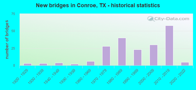
- New bridges - historical statistics
- 31920-1929
- 31930-1939
- 41940-1949
- 21950-1959
- 61960-1969
- 281970-1979
- 401980-1989
- 231990-1999
- 302000-2009
- 582010-2019
- 52020-2022
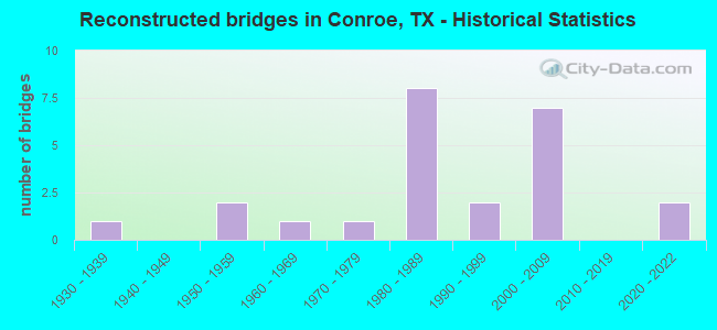
- Reconstructed bridges - Historical Statistics
- 11930-1939
- 01940-1949
- 21950-1959
- 11960-1969
- 11970-1979
- 81980-1989
- 21990-1999
- 72000-2009
- 02010-2019
- 22020-2022
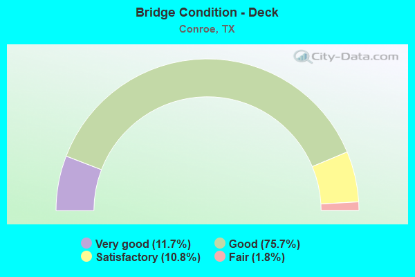
- Bridge Condition - Deck
- 11.7%Very good
- 75.7%Good
- 10.8%Satisfactory
- 1.8%Fair
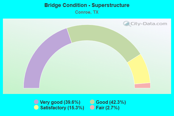
- Bridge Condition - Superstructure
- 39.6%Very good
- 42.3%Good
- 15.3%Satisfactory
- 2.7%Fair
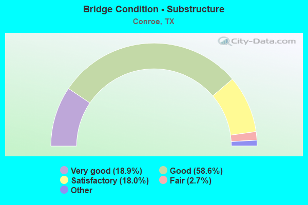
- Bridge Condition - Substructure
- 18.9%Excellent
- 58.6%Very good
- 18.0%Good
- 2.7%Satisfactory
- 1.8%Fair
- 0.9%Poor
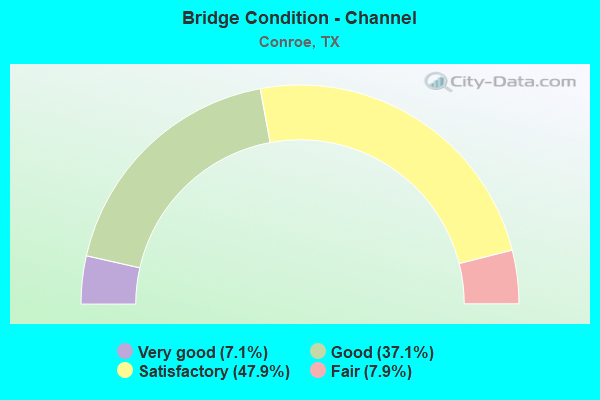
- Bridge Condition - Channel
- 7.1%Very good
- 37.1%Good
- 47.9%Satisfactory
- 7.9%Fair
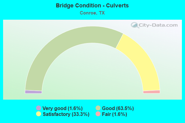
- Bridge Condition - Culverts
- 1.6%Very good
- 63.5%Good
- 33.3%Satisfactory
- 1.6%Fair
Find on map >> Show street view
Structure Number: 121700C01071001, Location: 0.16 MI W OF SCRBOROUGH (Lat: 30.287200, Lng: -95.469814), Route carried "on" structure: City street , Year Built: 2016, Status: Open, Structure Length: 0.73m (2.40ft), Average Daily Traffic: 100 (year 2016), Truck Traffic: 1%, Average Future Daily Traffic: 120 (year 2036), Features Intersected: DRAINAGE DITCH, Facility Carried by Structure: S RIVERSHIRE DR
Minimum Vertical Clearance: 30+ m (98+ ft), Kilometerpoint: 0.257, Lanes on structure: 2, Owner: City or Municipal Highway Agency, Approaching Roadway Width: 10.4m (34.1ft), Material/Design: Concrete, Design/Construction: Culvert, Number Of Spans In Main Unit: 2, Length of Maximum Span: 3.0m (9.8ft), Curb-To-Curb Width: 10.4m (34.1ft), Out-to-Out Width: 25.9m (85.0ft)
Condition: Channel: Very good, Culverts: Good, Operating Rating: 32.7 metric tons, Method Used To Determine Operating Rating: Field evaluation and documented engineering judgment, Inventory Rating: 24.5 metric tons, Method Used To Determine Inventory Rating: Field evaluation and documented engineering judgment, Structural Evaluation: Equal to present minimum criteria, Deck Geometry: Superior to present desirable criteria, Waterway Adequacy: Better than present minimum criteria, Approach Roadway Alignment: Equal to present desirable criteria, Designated Inspection Frequency: Every 24 months, Inspection Date: December 2021, Deck Structure Type: Concrete Precast Panels, Wearing Surface/Protective System: Wearing Surface: Bituminous
Find on map >> Show street view
Structure Number: 121700C01080115, Location: 0.36 MI N OF LEWIS ST (Lat: 30.321192, Lng: -95.460381), Route carried "on" structure: City street , Year Built: 1955, Status: Open, Structure Length: 1.01m (3.31ft), Average Daily Traffic: 4,090 (year 2013), Truck Traffic: 1%, Average Future Daily Traffic: 6,000 (year 2033), Features Intersected: PIN OAK BRANCH, Facility Carried by Structure: ROBERSON ST
Minimum Vertical Clearance: 30+ m (98+ ft), Kilometerpoint: 0.579, Lanes on structure: 2, Owner: Town or Township Highway Agency, Approaching Roadway Width: 10.4m (34.1ft), Skew: 3 degrees, Material/Design: Concrete, Design/Construction: Culvert, Number Of Spans In Main Unit: 5, Length of Maximum Span: 1.5m (4.9ft), Curb or Sidewalk Widths: Left: 1.2m (3.9ft), Right: 1.2m (3.9ft), Curb-To-Curb Width: 10.4m (34.1ft), Out-to-Out Width: 14.3m (46.9ft)
Condition: Channel: Satisfactory, Culverts: Satisfactory, Operating Rating: 32.7 metric tons, Method Used To Determine Operating Rating: Field evaluation and documented engineering judgment, Inventory Rating: 24.5 metric tons, Method Used To Determine Inventory Rating: Field evaluation and documented engineering judgment, Structural Evaluation: Equal to present minimum criteria, Deck Geometry: Somewhat better than minimum adequacy, Waterway Adequacy: Better than present minimum criteria, Approach Roadway Alignment: Equal to present desirable criteria, Length Of Structure Improvement: 0.98m (3.22ft), Designated Inspection Frequency: Every 24 months, Inspection Date: September 2021, Bridge Improvement Cost: $21,000, Roadway Improvement Cost: $5,000, Total Project Cost: $26,000, Deck Structure Type: Concrete Cast-file-Place, Wearing Surface/Protective System: Wearing Surface: Bituminous
Find on map >> Show street view
Structure Number: 121700C01165001, Location: 0.40 MI W OF FM 1314 (Lat: 30.301436, Lng: -95.438175), Route carried "on" structure: City street 661, Year Built: 1989, Status: Open, Structure Length: 3.41m (11.19ft), Average Daily Traffic: 9,750 (year 2013), Average Future Daily Traffic: 10,000 (year 2033), Features Intersected: STEWARTS CREEK, Facility Carried by Structure: SILVERDALE RD
Minimum Vertical Clearance: 30+ m (98+ ft), Kilometerpoint: 0.644, Lanes on structure: 4, Owner: Town or Township Highway Agency, Approaching Roadway Width: 14.0m (45.9ft), Material/Design: Prestressed concrete, Design/Construction: Box Beam or Girders - Multiple, Number Of Spans In Main Unit: 3, Length of Maximum Span: 11.3m (37.1ft), Curb-To-Curb Width: 20.7m (67.9ft), Out-to-Out Width: 21.3m (69.9ft)
Condition: Deck: Satisfactory, Superstructure: Good, Substructure: Good, Channel: Satisfactory, Operating Rating: 32.7 metric tons, Method Used To Determine Operating Rating: Field evaluation and documented engineering judgment, Inventory Rating: 24.5 metric tons, Method Used To Determine Inventory Rating: Field evaluation and documented engineering judgment, Structural Evaluation: Equal to present minimum criteria, Deck Geometry: Superior to present desirable criteria, Waterway Adequacy: Equal to present minimum criteria, Approach Roadway Alignment: Equal to present desirable criteria, Designated Inspection Frequency: Every 24 months, Inspection Date: August 2021, Deck Structure Type: Concrete Cast-file-Place
Find on map >> Show street view
Structure Number: 121700C01182001, Location: 0.60 MI N OF S LOOP 336 (Lat: 30.292900, Lng: -95.481181), Route carried "on" structure: City street , Year Built: 2004, Status: Open, Structure Length: 5.03m (16.50ft), Average Daily Traffic: 4,500 (year 2016), Truck Traffic: 1%, Average Future Daily Traffic: 15,000 (year 2036), Design Load: HS 20, Features Intersected: ALLIGATOR CREEK, Facility Carried by Structure: SGT ED HOLCOMB BLV
Minimum Vertical Clearance: 30+ m (98+ ft), Kilometerpoint: 0.966, Lanes on structure: 4, Owner: City or Municipal Highway Agency, Approaching Roadway Width: 13.4m (44.0ft), Material/Design: Prestressed concrete, Number Of Spans In Main Unit: 3, Length of Maximum Span: 16.8m (55.1ft), Curb-To-Curb Width: 13.2m (43.3ft), Out-to-Out Width: 14.0m (45.9ft)
Condition: Deck: Very good, Superstructure: Very good, Substructure: Good, Channel: Satisfactory, Operating Rating: 54.4 metric tons, Method Used To Determine Operating Rating: Assigned rating based on Load Factor Design (LFD) reported in metric tons, Inventory Rating: 32.7 metric tons, Method Used To Determine Inventory Rating: Assigned rating based on Load Factor Design (LFD) reported in metric tons, Structural Evaluation: Better than present minimum criteria, Deck Geometry: High priority of replacement, Waterway Adequacy: Equal to present minimum criteria, Approach Roadway Alignment: Equal to present desirable criteria, Designated Inspection Frequency: Every 24 months, Inspection Date: December 2021, Deck Structure Type: Concrete Cast-file-Place, Wearing Surface/Protective System: Wearing Surface: Bituminous
Find on map >> Show street view
Structure Number: 121700C026672, Location: 0.8 MI S Seven Cove RD (Lat: 30.385811, Lng: -95.442375), Route carried "on" structure: City street , Year Built: 2021, Status: Open, Structure Length: 13.72m (45.01ft), Average Daily Traffic: 200 (year 2021), Truck Traffic: 1%, Average Future Daily Traffic: 1 (year 1900), Design Load: HL 93, Features Intersected: E Fork Crystal Crk, Facility Carried by Structure: Conroe Park W Dr
Minimum Vertical Clearance: 30+ m (98+ ft), Kilometerpoint: 1.287, Lanes on structure: 4, Owner: City or Municipal Highway Agency, Approaching Roadway Width: 15.9m (52.2ft), Material/Design: Prestressed concrete, Design/Construction: Stringer/Multi-beam, Number Of Spans In Main Unit: 4, Length of Maximum Span: 36.6m (120.1ft), Curb-To-Curb Width: 15.9m (52.2ft), Out-to-Out Width: 16.5m (54.1ft)
Condition: Deck: Very good, Superstructure: Very good, Substructure: Excellent, Channel: Good, Operating Rating: 54.4 metric tons, Method Used To Determine Operating Rating: Assigned ratings based on Load and Resistance Factor Design (LRFD) reported in metric tons, Inventory Rating: 32.7 metric tons, Method Used To Determine Inventory Rating: Assigned ratings based on Load and Resistance Factor Design (LRFD) reported in metric tons, Structural Evaluation: Equal to present desirable criteria, Deck Geometry: Meets minimum limits, Waterway Adequacy: Superior to present desirable criteria, Approach Roadway Alignment: Equal to present desirable criteria, Designated Inspection Frequency: Every 24 months, Inspection Date: September 2021, Deck Structure Type: Concrete Cast-file-Place
Find on map >> Show street view
Structure Number: 12170001100414, Location: 2.00 MI N OF SH 242 (Lat: 30.236617, Lng: -95.458789), Route carried "under" structure: Interstate 45, Year Built: 1994, Structure Length: 0. m, Average Daily Traffic: 104,610 (year 2014), Truck Traffic: 9%, Features Intersected: FM 1488, Facility Carried by Structure: FM 1488
Minimum Vertical Clearance: 5.36m (17.59ft), Kilometerpoint: 14.285, Lanes on structure: 16, Material/Design: Prestressed concrete, Design/Construction: Stringer/Multi-beam, Length of Maximum Span: 35.7m (117.1ft)
Find on map >> Show street view
Structure Number: 121700011004183, Location: 1.35 MI N OF FM 1488 (Lat: 30.255861, Lng: -95.456528), Route carried "under" structure: City street , Year Built: 2007, Structure Length: 0. m, Average Daily Traffic: 3,000 (year 2016), Truck Traffic: 5%, Features Intersected: IH 45, Facility Carried by Structure: IH 45
Minimum Vertical Clearance: 5.26m (17.26ft), Kilometerpoint: 0.161, Lanes on structure: 4, Material/Design: Prestressed concrete, Design/Construction: Stringer/Multi-beam, Length of Maximum Span: 30.5m (100.1ft)
Find on map >> Show street view
Structure Number: 121700011004202, Location: 2.00 MI N OF FM 1488 (Lat: 30.265456, Lng: -95.456542), Route carried "under" structure: City street , Year Built: 2007, Structure Length: 0. m, Average Daily Traffic: 10,000 (year 2016), Truck Traffic: 9%, Features Intersected: IH 45 ML, Facility Carried by Structure: IH 45 ML
Minimum Vertical Clearance: 5.23m (17.16ft), Kilometerpoint: 0.161, Lanes on structure: 8, Lanes under structure: 5, Material/Design: Prestressed concrete, Design/Construction: Stringer/Multi-beam, Length of Maximum Span: 36.6m (120.1ft)
Find on map >> Show street view
Structure Number: 121700033811095, Location: 0.60 MI E OF SH 75 (Lat: 30.338114, Lng: -95.457300), Route carried "under" structure: City street , Year Built: 1970, Structure Length: 0. m, Average Daily Traffic: 100 (year 2012), Truck Traffic: 5%, Features Intersected: LP 336 EB, Facility Carried by Structure: LP 336 EB
Minimum Vertical Clearance: 6.71m (22.01ft), Kilometerpoint: 0.000, Lanes on structure: 2, Material/Design: Prestressed concrete, Design/Construction: Stringer/Multi-beam, Length of Maximum Span: 24.4m (80.1ft)
Find on map >> Show street view
Structure Number: 121700033811121, Location: 1.1MI S OF SH105 (Lat: 30.312919, Lng: -95.505650), Route carried "under" structure: State highway 2854, Year Built: 1989, Structure Length: 0. m, Average Daily Traffic: 10,600 (year 2013), Truck Traffic: 9%, Features Intersected: LP 336, Facility Carried by Structure: LP 336
Minimum Vertical Clearance: 7.04m (23.10ft), Kilometerpoint: 23.146, Lanes on structure: 3, Material/Design: Prestressed concrete, Design/Construction: Stringer/Multi-beam, Length of Maximum Span: 36.6m (120.1ft)
Find on map >> Show street view
Structure Number: 121700033811128, Location: 0.60 MI E OF SH 75 (Lat: 30.338528, Lng: -95.456969), Route carried "under" structure: City street , Year Built: 1970, Structure Length: 0. m, Average Daily Traffic: 100 (year 2012), Truck Traffic: 5%, Features Intersected: LP 336 WB, Facility Carried by Structure: LP 336 WB
Minimum Vertical Clearance: 6.71m (22.01ft), Kilometerpoint: 0.000, Lanes on structure: 2, Material/Design: Prestressed concrete, Design/Construction: Stringer/Multi-beam, Length of Maximum Span: 24.4m (80.1ft)
Find on map >> Show street view
Structure Number: 121700067508207, Location: 1.40 MI N OF SH 105 (Lat: 30.333714, Lng: -95.478144), Route carried "under" structure: Interstate 45, Year Built: 1989, Structure Length: 0. m, Average Daily Traffic: 78,020 (year 2013), Truck Traffic: 16%, Features Intersected: LP 336 WB, Facility Carried by Structure: LP 336 WB
Minimum Vertical Clearance: 6.40m (21.00ft), Kilometerpoint: 25.391, Lanes on structure: 9, Material/Design: Prestressed concrete, Design/Construction: Stringer/Multi-beam, Length of Maximum Span: 25.6m (84.0ft)
Find on map >> Show street view
Structure Number: 121700067508208, Location: 1.00 MI N OF CREIGHTN RD (Lat: 30.280244, Lng: -95.457369), Route carried "under" structure: State highway 336, Year Built: 1989, Structure Length: 0. m, Average Daily Traffic: 22,260 (year 2013), Truck Traffic: 8%, Features Intersected: IH 45 NB, Facility Carried by Structure: IH 45 NB
Minimum Vertical Clearance: 5.84m (19.16ft), Kilometerpoint: 7.113, Lanes on structure: 8, Material/Design: Prestressed concrete, Design/Construction: Stringer/Multi-beam, Length of Maximum Span: 25.9m (85.0ft)
Find on map >> Show street view
Structure Number: 121700067508209, Location: 1.00 MI N OF CREIGHTN RD (Lat: 30.279950, Lng: -95.457931), Route carried "under" structure: State highway 336, Year Built: 1989, Structure Length: 0. m, Average Daily Traffic: 22,260 (year 2013), Truck Traffic: 8%, Features Intersected: LP 336, Facility Carried by Structure: IH 45 SB
Minimum Vertical Clearance: 5.49m (18.01ft), Kilometerpoint: 7.141, Lanes on structure: 8, Toll: Toll bridge, Material/Design: Prestressed concrete, Design/Construction: Stringer/Multi-beam, Length of Maximum Span: 25.9m (85.0ft)
Find on map >> Show street view
Structure Number: 121700067508211, Location: 1.40 MI N OF SH 105 (Lat: 30.333672, Lng: -95.478478), Route carried "under" structure: Interstate 45, Year Built: 1989, Structure Length: 0. m, Average Daily Traffic: 73,410 (year 2016), Truck Traffic: 19%, Features Intersected: LP 336 EB, Facility Carried by Structure: LP 336 EB
Minimum Vertical Clearance: 6.40m (21.00ft), Kilometerpoint: 25.391, Lanes on structure: 12, Material/Design: Prestressed concrete, Design/Construction: Stringer/Multi-beam, Length of Maximum Span: 25.6m (84.0ft)
Find on map >> Show street view
Structure Number: 121700067508215, Location: AT IH 45 AND FM 2854 (Lat: 30.307942, Lng: -95.469789), Route carried "under" structure: State highway 2854, Year Built: 2003, Structure Length: 0. m, Average Daily Traffic: 10,600 (year 2011), Truck Traffic: 8%, Features Intersected: IH 45 SBFR, Facility Carried by Structure: IH 45 SBFR
Minimum Vertical Clearance: 8.13m (26.67ft), Kilometerpoint: 26.751, Lanes on structure: 4, Material/Design: Prestressed concrete, Design/Construction: Stringer/Multi-beam, Length of Maximum Span: 37.8m (124.0ft)
Find on map >> Show street view
Structure Number: 121700067508217, Location: 1.30 MI N OF LP 336 (Lat: 30.351000, Lng: -95.483300), Route carried "under" structure: Interstate 45, Year Built: 2008, Structure Length: 0. m, Average Daily Traffic: 80,990 (year 2016), Truck Traffic: 19%, Features Intersected: IH 45, Facility Carried by Structure: FM 3083
Minimum Vertical Clearance: 5.84m (19.16ft), Kilometerpoint: 27.426, Lanes on structure: 10, Material/Design: Prestressed concrete, Design/Construction: Stringer/Multi-beam, Length of Maximum Span: 31.1m (102.0ft)
Find on map >> Show street view
Structure Number: 121700067508218, Location: 0.80 MI N OF SH 105 (Lat: 30.325231, Lng: -95.474683), Route carried "under" structure: Interstate 45, Year Built: 2010, Structure Length: 0. m, Average Daily Traffic: 78,020 (year 2013), Truck Traffic: 16%, Features Intersected: WILSON RD, Facility Carried by Structure: WILSON RD
Minimum Vertical Clearance: 5.44m (17.85ft), Kilometerpoint: 24.776, Lanes on structure: 10, Material/Design: Prestressed concrete, Design/Construction: Stringer/Multi-beam, Length of Maximum Span: 34.1m (111.9ft)
Find on map >> Show street view
Structure Number: 121700067508219, Location: 1.60 MI S OF SH 105 (Lat: 30.293242, Lng: -95.464006), Route carried "under" structure: City street , Year Built: 2010, Structure Length: 0. m, Average Daily Traffic: 1,100 (year 2011), Features Intersected: IH 45 NB, Facility Carried by Structure: IH 45 NB
Minimum Vertical Clearance: 5.41m (17.75ft), Kilometerpoint: 1.674, Lanes on structure: 8, Material/Design: Prestressed concrete, Design/Construction: Stringer/Multi-beam, Length of Maximum Span: 36.9m (121.1ft)
Find on map >> Show street view
Structure Number: 12170006750822, Location: 1.60 MI S OF SH 105 (Lat: 30.292886, Lng: -95.464600), Route carried "under" structure: City street , Year Built: 2010, Structure Length: 0. m, Average Daily Traffic: 1,100 (year 2011), Features Intersected: IH 45 SB, Facility Carried by Structure: IH 45 SB
Minimum Vertical Clearance: 5.77m (18.93ft), Kilometerpoint: 1.674, Lanes on structure: 8, Material/Design: Prestressed concrete, Design/Construction: Stringer/Multi-beam, Length of Maximum Span: 36.9m (121.1ft)
Find on map >> Show street view
Structure Number: 121700067508221, Location: 0.50 MI N OF FM 2854 (Lat: 30.314911, Lng: -95.471914), Route carried "under" structure: State highway 105, Year Built: 2010, Structure Length: 0. m, Average Daily Traffic: 34,000 (year 2016), Truck Traffic: 6%, Features Intersected: IH 45 SB, Facility Carried by Structure: IH 45 SB
Minimum Vertical Clearance: 5.36m (17.59ft), Kilometerpoint: 35.286, Lanes on structure: 11, Material/Design: Steel continuous, Design/Construction: Stringer/Multi-beam, Length of Maximum Span: 65.5m (214.9ft)
Find on map >> Show street view
Structure Number: 121700067508222, Location: 0.50 MI N OF FM 2854 (Lat: 30.314667, Lng: -95.471050), Route carried "under" structure: State highway 105, Year Built: 2010, Structure Length: 0. m, Average Daily Traffic: 34,000 (year 2016), Truck Traffic: 6%, Features Intersected: IH 45 NB, Facility Carried by Structure: IH 45 NB
Minimum Vertical Clearance: 5.36m (17.59ft), Kilometerpoint: 35.286, Lanes on structure: 11, Material/Design: Steel continuous, Design/Construction: Stringer/Multi-beam, Length of Maximum Span: 65.5m (214.9ft)
Find on map >> Show street view
Structure Number: 121700067508223, Location: 0.50 MI S OF SH 105 (Lat: 30.307936, Lng: -95.469775), Route carried "under" structure: State highway 2854, Year Built: 2010, Structure Length: 0. m, Average Daily Traffic: 7,600 (year 2016), Truck Traffic: 6%, Features Intersected: IH 45 SB, Facility Carried by Structure: IH 45 SB
Minimum Vertical Clearance: 8.53m (27.99ft), Kilometerpoint: 26.675, Lanes on structure: 4, Material/Design: Steel, Design/Construction: Stringer/Multi-beam, Length of Maximum Span: 45.4m (149.0ft)
Find on map >> Show street view
Structure Number: 121700067508224, Location: 0.50 MI S OF SH 105 (Lat: 30.308231, Lng: -95.468722), Route carried "under" structure: State highway 2854, Year Built: 2010, Structure Length: 0. m, Average Daily Traffic: 7,600 (year 2016), Truck Traffic: 6%, Features Intersected: IH 45 NB, Facility Carried by Structure: IH 45 NB
Minimum Vertical Clearance: 7.26m (23.82ft), Kilometerpoint: 26.675, Lanes on structure: 4, Material/Design: Steel, Design/Construction: Stringer/Multi-beam, Length of Maximum Span: 56.4m (185.0ft)
Find on map >> Show street view
Structure Number: 121700067508225, Location: 0.50 MI S OF SH 105 (Lat: 30.308231, Lng: -95.468722), Route carried "under" structure: State highway 2854, Year Built: 2012, Structure Length: 0. m, Average Daily Traffic: 7,600 (year 2016), Truck Traffic: 6%, Features Intersected: IH 45 NBFR, Facility Carried by Structure: IH 45 NBFR
Minimum Vertical Clearance: 8.53m (27.99ft), Kilometerpoint: 26.675, Lanes on structure: 4, Material/Design: Steel continuous, Design/Construction: Stringer/Multi-beam, Length of Maximum Span: 73.2m (240.2ft)
Find on map >> Show street view
Structure Number: 121700067508226, Location: 0.1 MI N OF SH 105 (Lat: 30.319964, Lng: -95.473647), Route carried "under" structure: State highway 105, Year Built: 2012, Structure Length: 0. m, Average Daily Traffic: 34,000 (year 2016), Truck Traffic: 6%, Features Intersected: IH45 SB ENT RAMP, Facility Carried by Structure: IH45 SB ENT RAMP G
Minimum Vertical Clearance: 5.36m (17.59ft), Kilometerpoint: 35.286, Lanes on structure: 1, Material/Design: Prestressed concrete, Design/Construction: Stringer/Multi-beam, Length of Maximum Span: 38.1m (125.0ft)
Find on map >> Show street view
Structure Number: 121700067508227, Location: 1.2 MI SE OF LP 336 (Lat: 30.317461, Lng: -95.471964), Route carried "under" structure: Ramp Interstate 45, Year Built: 2012, Structure Length: 0. m, Average Daily Traffic: 30,000 (year 2011), Truck Traffic: 15%, Features Intersected: IH 45 NB EXIT RAMP
Minimum Vertical Clearance: 5.36m (17.59ft), Kilometerpoint: 0.000, Lanes on structure: 1, Material/Design: Steel continuous, Design/Construction: Stringer/Multi-beam, Length of Maximum Span: 80.8m (265.1ft)
Find on map >> Show street view
Structure Number: 12170006750823, Location: 1.7 MI S OF FM 830 (Lat: 30.366822, Lng: -95.484744), Route carried "under" structure: City street , Year Built: 2013, Structure Length: 0. m, Average Daily Traffic: 5,000 (year 2016), Truck Traffic: 3%, Features Intersected: IH 45 NB, Facility Carried by Structure: IH 45 NB
Minimum Vertical Clearance: 6.27m (20.57ft), Kilometerpoint: 29.137, Lanes on structure: 6, Material/Design: Prestressed concrete, Design/Construction: Stringer/Multi-beam, Length of Maximum Span: 39.0m (128.0ft)
Find on map >> Show street view
Structure Number: 121700067508231, Location: 1.7 MI S OF FM 830 (Lat: 30.366975, Lng: -95.485358), Route carried "under" structure: City street , Year Built: 2013, Structure Length: 0. m, Average Daily Traffic: 5,000 (year 2016), Truck Traffic: 3%, Features Intersected: IH 45 SB, Facility Carried by Structure: IH 45 SB
Minimum Vertical Clearance: 6.22m (20.41ft), Kilometerpoint: 29.150, Lanes on structure: 6, Material/Design: Prestressed concrete, Design/Construction: Stringer/Multi-beam, Length of Maximum Span: 39.3m (128.9ft)
Find on map >> Show street view
Structure Number: 121700067508234, Location: 5.40 MI N OF SH 105 (Lat: 30.391336, Lng: -95.486964), Route carried "under" structure: Interstate 45, Year Built: 2013, Structure Length: 0. m, Average Daily Traffic: 44,400 (year 2013), Truck Traffic: 19%, Features Intersected: IH 45, Facility Carried by Structure: FM 830
Minimum Vertical Clearance: 5.51m (18.08ft), Kilometerpoint: 31.876, Material/Design: Prestressed concrete, Design/Construction: Stringer/Multi-beam, Length of Maximum Span: 42.7m (140.1ft)
Find on map >> Show street view
Structure Number: 121700274401216, Location: 2.40 MI S OF SH 105 (Lat: 30.319525, Lng: -95.588189), Route carried "under" structure: State highway 2854, Year Built: 2011, Structure Length: 0. m, Average Daily Traffic: 2,300 (year 2016), Truck Traffic: 15%, Features Intersected: FISH CREEK ROAD, Facility Carried by Structure: FISH CREEK ROAD
Minimum Vertical Clearance: 7.29m (23.92ft), Kilometerpoint: 1.609, Lanes on structure: 2, Material/Design: Steel, Design/Construction: Stringer/Multi-beam, Length of Maximum Span: 47.2m (154.9ft)
Find on map >> Show street view
Structure Number: 121700274401218, Location: 2.4 MI S OF SH 105 (Lat: 30.317725, Lng: -95.588053), Route carried "under" structure: State highway 2854, Year Built: 2020, Structure Length: 0. m, Average Daily Traffic: 8,900 (year 2016), Truck Traffic: 7%, Features Intersected: FM 2854 / BNSF, Facility Carried by Structure: FISH CREEK RD NB
Minimum Vertical Clearance: 7.24m (23.75ft), Kilometerpoint: 14.204, Lanes on structure: 4, Material/Design: Steel, Design/Construction: Stringer/Multi-beam, Length of Maximum Span: 48.2m (158.1ft)
Find on map >> Show street view
Structure Number: 121700353801387, Location: JCT IH 45 and SH 242 (Lat: 30.206214, Lng: -95.455864), Route carried "under" structure: Interstate 45, Year Built: 2014, Structure Length: 0. m, Truck Traffic: 10%, Features Intersected: SH 242 WB to IH 45 SB DC
Minimum Vertical Clearance: 5.12m (16.80ft), Kilometerpoint: 0.000, Lanes on structure: 8, Material/Design: Steel continuous, Design/Construction: Stringer/Multi-beam, Length of Maximum Span: 95.4m (313.0ft)