Bridge Statistics for Farmington, New Mexico (NM)
Condition, Traffic, Stress, Structural Evaluation, Project Costs
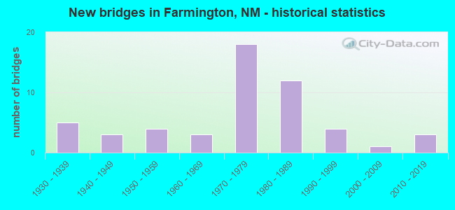
- New bridges - historical statistics
- 51930-1939
- 31940-1949
- 41950-1959
- 31960-1969
- 181970-1979
- 121980-1989
- 41990-1999
- 12000-2009
- 32010-2019

- Reconstructed bridges - Historical Statistics
- 11980-1989
- 01990-1999
- 12000-2009


- Bridge Condition - Deck
- 6.5%Very good
- 32.3%Good
- 54.8%Satisfactory
- 6.5%Fair

- Bridge Condition - Superstructure
- 12.9%Very good
- 51.6%Good
- 32.3%Satisfactory
- 3.2%Fair

- Bridge Condition - Substructure
- 6.5%Very good
- 51.6%Good
- 29.0%Satisfactory
- 12.9%Fair

- Bridge Condition - Channel
- 25.5%Very good
- 31.4%Good
- 33.3%Satisfactory
- 9.8%Fair

- Bridge Condition - Culverts
- 9.5%Very good
- 42.9%Good
- 38.1%Satisfactory
- 9.5%Fair
Find on map >> Show street view
Structure Number: N807, Location: 13 MI S,7 MI E FARMINGTON (Lat: 36.539306, Lng: -108.081528), Route carried "on" structure: Federal lands road 4030, Year Built: 1975, Status: Open, Structure Length: 2.35m (7.71ft), Average Daily Traffic: 263 (year 2022), Truck Traffic: 10%, Average Future Daily Traffic: 308 (year 2040), Design Load: HS 20, Features Intersected: DRAINAGE DITCH
Minimum Vertical Clearance: 30+ m (98+ ft), Kilometerpoint: 0.000, Lanes on structure: 2, Owner: Bureau of Indian Affairs, Approaching Roadway Width: 8.0m (26.2ft), Skew: 2 degrees, Material/Design: Prestressed concrete, Design/Construction: Stringer/Multi-beam, Number Of Spans In Main Unit: 1, Length of Maximum Span: 22.5m (73.8ft), Curb or Sidewalk Widths: Left: 0.4m (1.3ft), Right: 0.4m (1.3ft), Curb-To-Curb Width: 8.6m (28.2ft), Out-to-Out Width: 9.4m (30.8ft)
Condition: Deck: Satisfactory, Superstructure: Good, Substructure: Good, Channel: Good, Operating Rating: 44.5 metric tons, Method Used To Determine Operating Rating: Allowable Stress (AS), Inventory Rating: 32.7 metric tons, Method Used To Determine Inventory Rating: Allowable Stress (AS), Structural Evaluation: Better than present minimum criteria, Deck Geometry: Equal to present minimum criteria, Waterway Adequacy: Superior to present desirable criteria, Approach Roadway Alignment: Equal to present desirable criteria, Designated Inspection Frequency: Every 24 months, Inspection Date: January 2022, Deck Structure Type: Concrete Cast-file-Place, Wearing Surface/Protective System: Wearing Surface: Monolithic Concrete
Find on map >> Show street view
Structure Number: N808, Location: 9 MI S, 4 MI W FARMINGTON (Lat: 36.601028, Lng: -108.270861), Route carried "on" structure: Federal lands road 4055, Year Built: 1978, Status: Open, Structure Length: 1.17m (3.84ft), Average Daily Traffic: 269 (year 2022), Truck Traffic: 4%, Average Future Daily Traffic: 227 (year 2040), Design Load: HS 20, Features Intersected: AMARILLO CANAL NO.1
Minimum Vertical Clearance: 30+ m (98+ ft), Kilometerpoint: 17.055, Lanes on structure: 2, Owner: Bureau of Indian Affairs, Approaching Roadway Width: 8.3m (27.2ft), Skew: 1 degrees, Material/Design: Prestressed concrete, Design/Construction: Stringer/Multi-beam, Number Of Spans In Main Unit: 1, Length of Maximum Span: 11.2m (36.7ft), Curb or Sidewalk Widths: Left: 0.4m (1.3ft), Right: 0.4m (1.3ft), Curb-To-Curb Width: 8.5m (27.9ft), Out-to-Out Width: 9.4m (30.8ft)
Condition: Deck: Good, Superstructure: Very good, Substructure: Satisfactory, Channel: Very good, Operating Rating: 44.5 metric tons, Method Used To Determine Operating Rating: Allowable Stress (AS), Inventory Rating: 32.7 metric tons, Method Used To Determine Inventory Rating: Allowable Stress (AS), Structural Evaluation: Equal to present minimum criteria, Deck Geometry: Equal to present minimum criteria, Waterway Adequacy: Superior to present desirable criteria, Approach Roadway Alignment: Equal to present desirable criteria, Designated Inspection Frequency: Every 24 months, Inspection Date: January 2022, Deck Structure Type: Concrete Cast-file-Place, Wearing Surface/Protective System: Wearing Surface: Monolithic Concrete
Find on map >> Show street view
Structure Number: N809, Location: 11 MI S,8 MI W FARMINGTON (Lat: 36.567736, Lng: -108.350417), Route carried "on" structure: Federal lands road 4065, Year Built: 1978, Status: Open, Structure Length: 0.95m (3.12ft), Average Daily Traffic: 271 (year 2022), Truck Traffic: 6%, Average Future Daily Traffic: 229 (year 2040), Design Load: HS 20, Features Intersected: AMARILLO CANAL NO 2
Minimum Vertical Clearance: 30+ m (98+ ft), Kilometerpoint: 11.907, Lanes on structure: 2, Owner: Bureau of Indian Affairs, Approaching Roadway Width: 9.1m (29.9ft), Material/Design: Prestressed concrete, Design/Construction: Stringer/Multi-beam, Number Of Spans In Main Unit: 1, Length of Maximum Span: 8.9m (29.2ft), Curb or Sidewalk Widths: Left: 0.4m (1.3ft), Right: 0.4m (1.3ft), Curb-To-Curb Width: 8.5m (27.9ft), Out-to-Out Width: 9.4m (30.8ft)
Condition: Deck: Good, Superstructure: Good, Substructure: Satisfactory, Channel: Very good, Operating Rating: 44.5 metric tons, Method Used To Determine Operating Rating: Allowable Stress (AS), Inventory Rating: 32.7 metric tons, Method Used To Determine Inventory Rating: Allowable Stress (AS), Structural Evaluation: Equal to present minimum criteria, Deck Geometry: Equal to present minimum criteria, Waterway Adequacy: Superior to present desirable criteria, Approach Roadway Alignment: Equal to present desirable criteria, Designated Inspection Frequency: Every 24 months, Inspection Date: January 2022, Deck Structure Type: Concrete Cast-file-Place, Wearing Surface/Protective System: Wearing Surface: Monolithic Concrete
Find on map >> Show street view
Structure Number: N814, Location: 5.8 M S,6.2M W FARMINGTON (Lat: 36.647139, Lng: -108.308583), Route carried "on" structure: Federal lands road 3003, Year Built: 1978, Status: Open, Structure Length: 0.80m (2.62ft), Average Daily Traffic: 2,768 (year 2022), Truck Traffic: 30%, Average Future Daily Traffic: 3,446 (year 2040), Design Load: HS 20, Features Intersected: NAVAJO WASH
Minimum Vertical Clearance: 30+ m (98+ ft), Kilometerpoint: 9.654, Lanes on structure: 2, Owner: Bureau of Indian Affairs, Approaching Roadway Width: 12.6m (41.3ft), Material/Design: Steel, Design/Construction: Culvert, Number Of Spans In Main Unit: 1, Length of Maximum Span: 8.0m (26.2ft), Curb-To-Curb Width: 12.6m (41.3ft), Out-to-Out Width: 36.7m (120.4ft)
Condition: Channel: Good, Culverts: Good, Operating Rating: 44.5 metric tons, Method Used To Determine Operating Rating: Allowable Stress (AS), Inventory Rating: 32.7 metric tons, Method Used To Determine Inventory Rating: Allowable Stress (AS), Structural Evaluation: Better than present minimum criteria, Deck Geometry: Equal to present minimum criteria, Waterway Adequacy: Better than present minimum criteria, Approach Roadway Alignment: Equal to present desirable criteria, Designated Inspection Frequency: Every 24 months, Inspection Date: January 2022
Find on map >> Show street view
Structure Number: N815, Location: 8.6M S,13M W FARMINGTON (Lat: 36.609972, Lng: -108.431750), Route carried "on" structure: Federal lands road 3005, Year Built: 1978, Status: Open, Structure Length: 1.05m (3.44ft), Average Daily Traffic: 841 (year 2022), Truck Traffic: 7%, Average Future Daily Traffic: 3,363 (year 2040), Features Intersected: COAL WASH
Minimum Vertical Clearance: 30+ m (98+ ft), Kilometerpoint: 6.440, Lanes on structure: 2, Owner: Bureau of Indian Affairs, Approaching Roadway Width: 10.8m (35.4ft), Skew: 2 degrees, Material/Design: Steel, Design/Construction: Culvert, Number Of Spans In Main Unit: 1, Length of Maximum Span: 10.5m (34.4ft), Curb-To-Curb Width: 10.8m (35.4ft), Out-to-Out Width: 42.0m (137.8ft)
Condition: Channel: Fair, Culverts: Fair, Structural Evaluation: Somewhat better than minimum adequacy, Deck Geometry: Equal to present minimum criteria, Waterway Adequacy: Equal to present minimum criteria, Approach Roadway Alignment: Better than present minimum criteria, Length Of Structure Improvement: 1.05m (3.44ft), Designated Inspection Frequency: Every 24 months, Inspection Date: January 2022, Bridge Improvement Cost: $75,000, Total Project Cost: $75,000 ( Estimate for 2022)
Find on map >> Show street view
Structure Number: N816, Location: 2.2M S,0.3M W JCT44 -3003 (Lat: 36.565361, Lng: -108.015611), Route carried "on" structure: Federal lands road 4028, Year Built: 1980, Status: Open, Structure Length: 1.16m (3.81ft), Average Daily Traffic: 187 (year 2022), Truck Traffic: 10%, Average Future Daily Traffic: 219 (year 2040), Design Load: HS 20, Features Intersected: COURY LATERAL CANAL
Minimum Vertical Clearance: 30+ m (98+ ft), Kilometerpoint: 3.379, Lanes on structure: 2, Owner: Bureau of Indian Affairs, Approaching Roadway Width: 9.0m (29.5ft), Skew: 3 degrees, Material/Design: Prestressed concrete, Design/Construction: Slab, Number Of Spans In Main Unit: 1, Length of Maximum Span: 11.1m (36.4ft), Curb or Sidewalk Widths: Left: 0.4m (1.3ft), Right: 0.4m (1.3ft), Curb-To-Curb Width: 9.0m (29.5ft), Out-to-Out Width: 9.8m (32.2ft)
Condition: Deck: Satisfactory, Superstructure: Satisfactory, Substructure: Satisfactory, Channel: Very good, Operating Rating: 44.5 metric tons, Method Used To Determine Operating Rating: Allowable Stress (AS), Inventory Rating: 32.7 metric tons, Method Used To Determine Inventory Rating: Allowable Stress (AS), Structural Evaluation: Equal to present minimum criteria, Deck Geometry: Equal to present minimum criteria, Waterway Adequacy: Superior to present desirable criteria, Approach Roadway Alignment: Equal to present desirable criteria, Designated Inspection Frequency: Every 24 months, Inspection Date: January 2022, Deck Structure Type: Concrete Precast Panels, Wearing Surface/Protective System: Wearing Surface: Monolithic Concrete
Find on map >> Show street view
Structure Number: N817, Location: 3.3M S,6M W JCT 44 & 3003 (Lat: 36.548250, Lng: -108.016861), Route carried "on" structure: Federal lands road 4022, Year Built: 1980, Status: Open, Structure Length: 1.00m (3.28ft), Average Daily Traffic: 631 (year 2022), Truck Traffic: 10%, Average Future Daily Traffic: 738 (year 2040), Design Load: HS 20, Features Intersected: COURY LATERAL CANAL
Minimum Vertical Clearance: 30+ m (98+ ft), Kilometerpoint: 10.459, Lanes on structure: 2, Owner: Bureau of Indian Affairs, Approaching Roadway Width: 8.8m (28.9ft), Material/Design: Prestressed concrete, Design/Construction: Slab, Number Of Spans In Main Unit: 1, Length of Maximum Span: 9.7m (31.8ft), Curb or Sidewalk Widths: Left: 0.4m (1.3ft), Right: 0.4m (1.3ft), Curb-To-Curb Width: 9.0m (29.5ft), Out-to-Out Width: 9.8m (32.2ft)
Condition: Deck: Good, Superstructure: Good, Substructure: Satisfactory, Channel: Satisfactory, Operating Rating: 44.5 metric tons, Method Used To Determine Operating Rating: Allowable Stress (AS), Inventory Rating: 32.7 metric tons, Method Used To Determine Inventory Rating: Allowable Stress (AS), Structural Evaluation: Equal to present minimum criteria, Deck Geometry: Somewhat better than minimum adequacy, Waterway Adequacy: Superior to present desirable criteria, Approach Roadway Alignment: Equal to present desirable criteria, Designated Inspection Frequency: Every 24 months, Inspection Date: January 2022, Deck Structure Type: Concrete Precast Panels, Wearing Surface/Protective System: Wearing Surface: Monolithic Concrete
Find on map >> Show street view
Structure Number: N818, Location: 3.5 MI E OF CHACO PLANT (Lat: 36.497472, Lng: -108.062722), Route carried "on" structure: Federal lands road 3002, Year Built: 1984, Status: Open, Structure Length: 4.60m (15.09ft), Average Daily Traffic: 1,000 (year 2022), Truck Traffic: 20%, Average Future Daily Traffic: 581 (year 2040), Design Load: HS 20+Mod, Features Intersected: GALLEGOS WASH
Minimum Vertical Clearance: 30+ m (98+ ft), Kilometerpoint: 4.023, Lanes on structure: 2, Owner: Bureau of Indian Affairs, Approaching Roadway Width: 9.4m (30.8ft), Material/Design: Steel continuous, Design/Construction: Stringer/Multi-beam, Number Of Spans In Main Unit: 3, Length of Maximum Span: 18.4m (60.4ft), Curb-To-Curb Width: 10.1m (33.1ft), Out-to-Out Width: 11.1m (36.4ft)
Condition: Deck: Satisfactory, Superstructure: Satisfactory, Substructure: Good, Channel: Very good, Operating Rating: 63.3 metric tons, Method Used To Determine Operating Rating: Allowable Stress (AS), Inventory Rating: 39.9 metric tons, Method Used To Determine Inventory Rating: Allowable Stress (AS), Structural Evaluation: Equal to present minimum criteria, Deck Geometry: Equal to present minimum criteria, Waterway Adequacy: Better than present minimum criteria, Approach Roadway Alignment: Equal to present desirable criteria, Designated Inspection Frequency: Every 24 months, Inspection Date: January 2022, Deck Structure Type: Concrete Cast-file-Place, Wearing Surface/Protective System: Wearing Surface: Monolithic Concrete
Find on map >> Show street view
Structure Number: 10049, Location: 1.2 M SE OF NM 170 (Lat: 36.754758, Lng: -108.219867), Route carried "on" structure: City street 4396, Year Built: 1992, Status: Open, Structure Length: 0.98m (3.22ft), Average Daily Traffic: 4,475 (year 2020), Truck Traffic: 7%, Average Future Daily Traffic: 5,013 (year 2040), Design Load: HS 20, Features Intersected: GLADE WASH
Minimum Vertical Clearance: 30+ m (98+ ft), Kilometerpoint: 0.612, Lanes on structure: 2, Owner: City or Municipal Highway Agency, Approaching Roadway Width: 8.8m (28.9ft), Skew: 10 degrees, Material/Design: Steel, Design/Construction: Culvert, Number Of Spans In Main Unit: 1, Length of Maximum Span: 9.8m (32.2ft)
Condition: Channel: Satisfactory, Culverts: Good, Operating Rating: 48.6 metric tons, Method Used To Determine Operating Rating: Load Factor (LF), Inventory Rating: 32.4 metric tons, Method Used To Determine Inventory Rating: Load Factor (LF), Structural Evaluation: Better than present minimum criteria, Waterway Adequacy: Better than present minimum criteria, Approach Roadway Alignment: Equal to present desirable criteria, Designated Inspection Frequency: Every 48 months, Inspection Date: September 2021
Find on map >> Show street view
Structure Number: 10051, Location: 1.2 M SE OF NM 170 (Lat: 36.754961, Lng: -108.219792), Route carried "on" structure: City street 4396, Year Built: 1992, Status: Open, Structure Length: 0.94m (3.08ft), Average Daily Traffic: 4,475 (year 2020), Truck Traffic: 7%, Average Future Daily Traffic: 5,013 (year 2040), Design Load: HS 20, Features Intersected: GLADE WASH
Minimum Vertical Clearance: 30+ m (98+ ft), Kilometerpoint: 0.628, Lanes on structure: 2, Owner: City or Municipal Highway Agency, Approaching Roadway Width: 8.5m (27.9ft), Skew: 10 degrees, Material/Design: Steel, Design/Construction: Culvert, Number Of Spans In Main Unit: 1, Length of Maximum Span: 9.4m (30.8ft), Curb or Sidewalk Widths: Left: 0.2m (0.7ft), Right: 0.2m (0.7ft)
Condition: Channel: Satisfactory, Culverts: Good, Operating Rating: 48.6 metric tons, Method Used To Determine Operating Rating: Load Factor (LF), Inventory Rating: 32.4 metric tons, Method Used To Determine Inventory Rating: Load Factor (LF), Structural Evaluation: Better than present minimum criteria, Waterway Adequacy: Better than present minimum criteria, Approach Roadway Alignment: Equal to present desirable criteria, Designated Inspection Frequency: Every 48 months, Inspection Date: September 2017
Find on map >> Show street view
Structure Number: 9036, Location: 16.8 MI N OF US-64 (Lat: 36.963131, Lng: -108.193036), Route carried "under" structure: State highway 170, Year Built: 1986, Structure Length: 0. m, Average Daily Traffic: 2,000 (year 2020), Truck Traffic: 16%, Features Intersected: NM-170, Facility Carried by Structure: 45-1120
Minimum Vertical Clearance: 5.46m (17.91ft), Kilometerpoint: 27.280, Lanes on structure: 2, Lanes under structure: 2, Material/Design: Steel, Design/Construction: Stringer/Multi-beam, Length of Maximum Span: 34.4m (112.9ft)