Bridge Statistics for Franklin, Tennessee (TN)
Condition, Traffic, Stress, Structural Evaluation, Project Costs
- National Bridge Inventory (NBI) Statistics
- 122Number of bridges
- 1,194ft / 364mTotal length
- $28,137,000Total costs
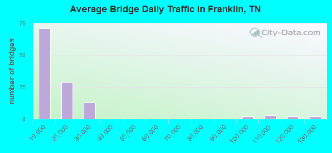
- 1,783,913Total average daily traffic
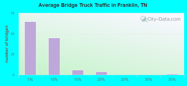
- 208,005Total average daily truck traffic
- National Bridge Inventory (NBI) Registered Bridges for Franklin
- No street view available for this location
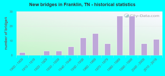
- New bridges - historical statistics
- 21900-1909
- 31920-1929
- 31930-1939
- 61940-1949
- 121950-1959
- 151960-1969
- 81970-1979
- 271980-1989
- 271990-1999
- 82000-2009
- 112010-2019
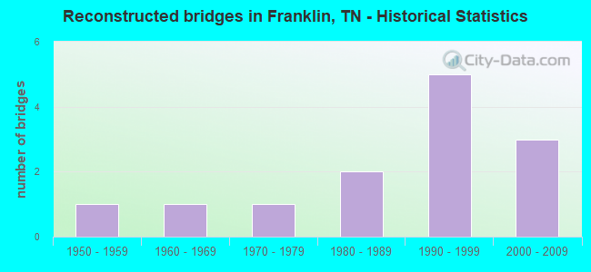
- Reconstructed bridges - Historical Statistics
- 11950-1959
- 11960-1969
- 11970-1979
- 21980-1989
- 51990-1999
- 32000-2009
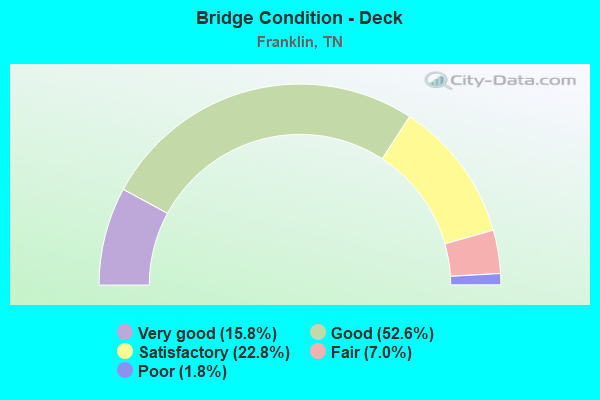
- Bridge Condition - Deck
- 15.8%Very good
- 52.6%Good
- 22.8%Satisfactory
- 7.0%Fair
- 1.8%Poor
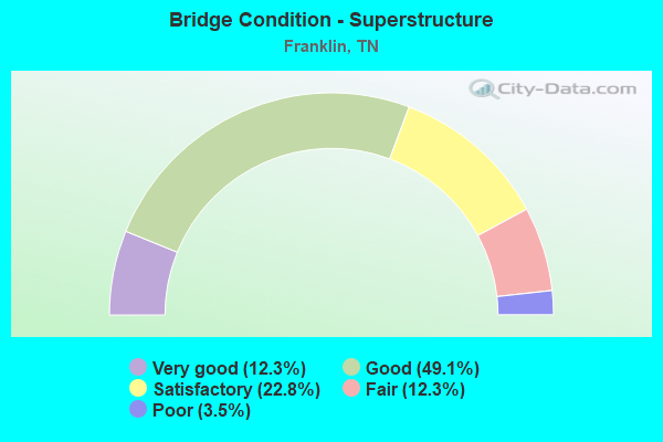
- Bridge Condition - Superstructure
- 12.3%Very good
- 49.1%Good
- 22.8%Satisfactory
- 12.3%Fair
- 3.5%Poor
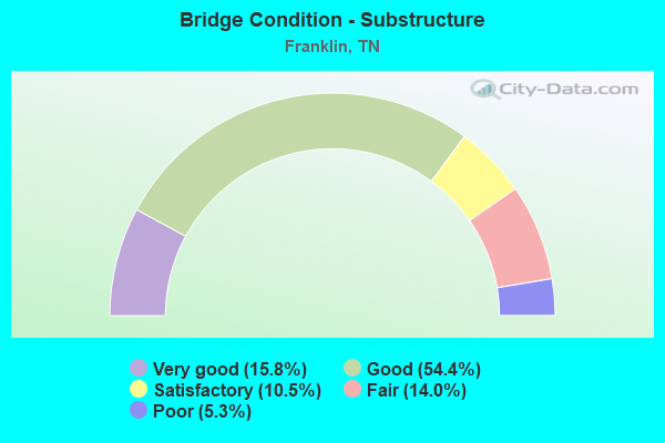
- Bridge Condition - Substructure
- 15.8%Very good
- 54.4%Good
- 10.5%Satisfactory
- 14.0%Fair
- 5.3%Poor
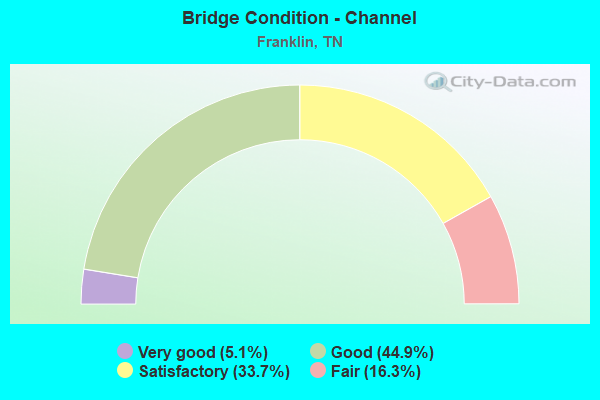
- Bridge Condition - Channel
- 5.1%Very good
- 44.9%Good
- 33.7%Satisfactory
- 16.3%Fair
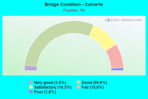
- Bridge Condition - Culverts
- 3.5%Very good
- 59.6%Good
- 19.3%Satisfactory
- 15.8%Fair
- 1.8%Poor
Find on map >> Show street view
Structure Number: 94SR0960001, Location: 4.7 M SE JCT I40&SR96 (Lat: 35.983967, Lng: -87.114900), Route carried "on" structure: State highway 100, Year Built: 1957, Year Reconstructed: 2001, Status: Posted for load, Structure Length: 3.90m (12.80ft), Average Daily Traffic: 12,719 (year 2020), Truck Traffic: 9%, Average Future Daily Traffic: 20,350 (year 2042), Design Load: HS 20, Features Intersected: SR 100 RL / SR 96
Minimum Vertical Clearance: 30+ m (98+ ft), Kilometerpoint: 10.654, Lanes on structure: 2, Lanes under structure: 2, Base Highway Network: Yes, Owner: State Highway Agency, Approaching Roadway Width: 10.9m (35.8ft), Skew: 12 degrees, Material/Design: Prestressed concrete continuous, Design/Construction: Box Beam or Girders - Single/Spread, Number Of Spans In Main Unit: 3, Length of Maximum Span: 14.6m (47.9ft), Curb-To-Curb Width: 11.2m (36.7ft), Out-to-Out Width: 12.3m (40.4ft)
Condition: Deck: Good, Superstructure: Very good, Substructure: Fair, Operating Rating: 38.2 metric tons, Method Used To Determine Operating Rating: Load and Resistance Factor Rating (LRFR) rating reported by rating factor(RF) method using HL-93 loadings, Inventory Rating: 25.6 metric tons, Method Used To Determine Inventory Rating: Load and Resistance Factor Rating (LRFR) rating reported by rating factor(RF) method using HL-93 loadings, Structural Evaluation: Somewhat better than minimum adequacy, Deck Geometry: Equal to present minimum criteria, Underclear: High priority of corrective action, Approach Roadway Alignment: Equal to present desirable criteria, Designated Inspection Frequency: Every 24 months, Inspection Date: January 2021, Deck Structure Type: Concrete Precast Panels, Wearing Surface/Protective System: Wearing Surface: Monolithic Concrete, Deck Protection: Epoxy Coated Reinforcing
Find on map >> Show street view
Structure Number: 94SR0960007, Location: .5 M SE JCT SR96&SR46 (Lat: 35.944533, Lng: -86.944433), Route carried "on" structure: State highway 96, Year Built: 1963, Year Reconstructed: 1992, Status: Open, Structure Length: 9.20m (30.18ft), Average Daily Traffic: 15,773 (year 2020), Truck Traffic: 9%, Average Future Daily Traffic: 25,237 (year 2041), Design Load: HS 20, Features Intersected: WEST HARPETH RIVER
Minimum Vertical Clearance: 30+ m (98+ ft), Kilometerpoint: 9.077, Lanes on structure: 2, Base Highway Network: Yes, Owner: State Highway Agency, Approaching Roadway Width: 12.2m (40.0ft), Material/Design: Prestressed concrete, Design/Construction: Stringer/Multi-beam, Number Of Spans In Main Unit: 5, Length of Maximum Span: 18.6m (61.0ft), Curb-To-Curb Width: 8.5m (27.9ft), Out-to-Out Width: 10.5m (34.4ft)
Condition: Deck: Fair, Superstructure: Good, Substructure: Good, Channel: Satisfactory, Operating Rating: 65.7 metric tons, Method Used To Determine Operating Rating: Load Factor (LF), Inventory Rating: 32.4 metric tons, Method Used To Determine Inventory Rating: Load Factor (LF), Structural Evaluation: Better than present minimum criteria, Deck Geometry: Meets minimum limits, Waterway Adequacy: Equal to present minimum criteria, Approach Roadway Alignment: Equal to present desirable criteria, Length Of Structure Improvement: 9.20m (30.18ft), Designated Inspection Frequency: Every 24 months, Underwater Inspection Frequency: Every 60 months, Inspection Date: January 2021, Underwater Inspection Date: June 2021, Bridge Improvement Cost: $765,000, Roadway Improvement Cost: $77,000, Total Project Cost: $1,148,000 ( Estimate for 2021), Deck Structure Type: Concrete Cast-file-Place, Wearing Surface/Protective System: Wearing Surface: Bituminous
Find on map >> Show street view
Structure Number: 94SR0960011, Location: .4 M SW JCT SR96&SR106 (Lat: 35.923767, Lng: -86.878517), Route carried "on" structure: State highway 96, Year Built: 1973, Status: Open, Structure Length: 0.67m (2.20ft), Average Daily Traffic: 15,442 (year 2020), Truck Traffic: 9%, Average Future Daily Traffic: 31,728 (year 2041), Design Load: HS 20, Features Intersected: SHARPS BRANCH
Minimum Vertical Clearance: 30+ m (98+ ft), Kilometerpoint: 15.675, Lanes on structure: 2, Base Highway Network: Yes, Owner: State Highway Agency, Approaching Roadway Width: 12.2m (40.0ft), Skew: 1 degrees, Material/Design: Concrete continuous, Design/Construction: Culvert, Number Of Spans In Main Unit: 2, Length of Maximum Span: 3.0m (9.8ft)
Condition: Channel: Satisfactory, Culverts: Fair, Operating Rating: 54.0 metric tons, Method Used To Determine Operating Rating: Field evaluation and documented engineering judgment, Inventory Rating: 32.4 metric tons, Method Used To Determine Inventory Rating: Field evaluation and documented engineering judgment, Structural Evaluation: Somewhat better than minimum adequacy, Waterway Adequacy: Equal to present minimum criteria, Approach Roadway Alignment: Equal to present desirable criteria, Length Of Structure Improvement: 0.67m (2.20ft), Designated Inspection Frequency: Every 24 months, Inspection Date: January 2021, Bridge Improvement Cost: $160,000, Roadway Improvement Cost: $17,000, Total Project Cost: $241,000 ( Estimate for 2021)
Find on map >> Show street view
Structure Number: 94SR0960013, Location: .4 M SE JCT SR96&SR6 (Lat: 35.920533, Lng: -86.865317), Route carried "on" structure: State highway 96, Year Built: 1958, Year Reconstructed: 1995, Status: Open, Structure Length: 6.86m (22.51ft), Average Daily Traffic: 15,623 (year 2020), Truck Traffic: 9%, Average Future Daily Traffic: 24,997 (year 2042), Design Load: HS 20, Features Intersected: HARPETH RIVER
Minimum Vertical Clearance: 30+ m (98+ ft), Kilometerpoint: 17.284, Lanes on structure: 4, Base Highway Network: Yes, Owner: State Highway Agency, Approaching Roadway Width: 16.5m (54.1ft), Material/Design: Concrete, Design/Construction: Tee Beam, Number Of Spans In Main Unit: 7, Length of Maximum Span: 11.3m (37.1ft), Curb or Sidewalk Widths: Left: 1.8m (5.9ft), Right: 1.8m (5.9ft), Curb-To-Curb Width: 17.1m (56.1ft), Out-to-Out Width: 21.5m (70.5ft)
Condition: Deck: Poor, Superstructure: Fair, Substructure: Fair, Channel: Satisfactory, Operating Rating: 55.8 metric tons, Method Used To Determine Operating Rating: Load Factor (LF), Inventory Rating: 32.4 metric tons, Method Used To Determine Inventory Rating: Load Factor (LF), Structural Evaluation: Somewhat better than minimum adequacy, Deck Geometry: Somewhat better than minimum adequacy, Waterway Adequacy: Equal to present minimum criteria, Approach Roadway Alignment: Equal to present desirable criteria, Length Of Structure Improvement: 6.86m (22.51ft), Designated Inspection Frequency: Every 24 months, Inspection Date: Febuary 2021, Bridge Improvement Cost: $2,166,000, Roadway Improvement Cost: $217,000, Total Project Cost: $3,250,000 ( Estimate for 2022), Deck Structure Type: Concrete Cast-file-Place, Wearing Surface/Protective System: Wearing Surface: Bituminous, Membrane: Preformed Fabric
Find on map >> Show street view
Structure Number: 94SR0960015, Location: .7 M E JCT SR96&I65 (Lat: 35.910217, Lng: -86.813183), Route carried "on" structure: State highway 96, Year Built: 1995, Status: Open, Structure Length: 1.68m (5.51ft), Average Daily Traffic: 24,301 (year 2020), Truck Traffic: 9%, Average Future Daily Traffic: 38,882 (year 2041), Design Load: HS 20, Features Intersected: WATSON BRANCH
Minimum Vertical Clearance: 30+ m (98+ ft), Kilometerpoint: 22.289, Lanes on structure: 4, Base Highway Network: Yes, Owner: State Highway Agency, Approaching Roadway Width: 25.6m (84.0ft), Skew: 4 degrees, Material/Design: Concrete continuous, Design/Construction: Culvert, Number Of Spans In Main Unit: 2, Length of Maximum Span: 5.5m (18.0ft)
Condition: Channel: Good, Culverts: Satisfactory, Operating Rating: 54.0 metric tons, Method Used To Determine Operating Rating: Field evaluation and documented engineering judgment, Inventory Rating: 32.4 metric tons, Method Used To Determine Inventory Rating: Field evaluation and documented engineering judgment, Structural Evaluation: Equal to present minimum criteria, Waterway Adequacy: Better than present minimum criteria, Approach Roadway Alignment: Equal to present desirable criteria, Length Of Structure Improvement: 1.68m (5.51ft), Designated Inspection Frequency: Every 24 months, Inspection Date: Febuary 2021, Bridge Improvement Cost: $635,000, Roadway Improvement Cost: $64,000, Total Project Cost: $953,000 ( Estimate for 2021)
Find on map >> Show street view
Structure Number: 94SR0960017, Location: 3.7 M SE JCT SR96&I65 (Lat: 35.892667, Lng: -86.767500), Route carried "on" structure: State highway 96, Year Built: 1948, Status: Open, Structure Length: 0.88m (2.89ft), Average Daily Traffic: 12,477 (year 2020), Truck Traffic: 9%, Average Future Daily Traffic: 19,963 (year 2041), Design Load: H 20, Features Intersected: BRANCH
Minimum Vertical Clearance: 30+ m (98+ ft), Kilometerpoint: 26.908, Lanes on structure: 2, Base Highway Network: Yes, Owner: State Highway Agency, Approaching Roadway Width: 10.4m (34.1ft), Skew: 4 degrees, Material/Design: Concrete, Design/Construction: Tee Beam, Number Of Spans In Main Unit: 1, Length of Maximum Span: 8.8m (28.9ft), Curb-To-Curb Width: 7.9m (25.9ft), Out-to-Out Width: 9.8m (32.2ft)
Condition: Deck: Satisfactory, Superstructure: Satisfactory, Substructure: Satisfactory, Channel: Satisfactory, Operating Rating: 54.0 metric tons, Method Used To Determine Operating Rating: Load Factor (LF), Inventory Rating: 32.4 metric tons, Method Used To Determine Inventory Rating: Load Factor (LF), Structural Evaluation: Equal to present minimum criteria, Deck Geometry: High priority of replacement, Waterway Adequacy: Equal to present minimum criteria, Approach Roadway Alignment: Equal to present minimum criteria, Length Of Structure Improvement: 0.88m (2.89ft), Designated Inspection Frequency: Every 24 months, Inspection Date: Febuary 2021, Bridge Improvement Cost: $110,000, Roadway Improvement Cost: $12,000, Total Project Cost: $166,000 ( Estimate for 2021), Deck Structure Type: Concrete Cast-file-Place, Wearing Surface/Protective System: Wearing Surface: Bituminous
Find on map >> Show street view
Structure Number: 94SR0960019, Location: 3.8 M SE JCT SR96&I65 (Lat: 35.892467, Lng: -86.767117), Route carried "on" structure: State highway 96, Year Built: 1948, Year Reconstructed: 1965, Status: Open, Structure Length: 2.62m (8.60ft), Average Daily Traffic: 12,477 (year 2020), Truck Traffic: 9%, Average Future Daily Traffic: 19,963 (year 2042), Design Load: H 20, Features Intersected: MAYES CREEK
Minimum Vertical Clearance: 30+ m (98+ ft), Kilometerpoint: 26.973, Lanes on structure: 2, Base Highway Network: Yes, Owner: State Highway Agency, Approaching Roadway Width: 10.4m (34.1ft), Material/Design: Concrete, Design/Construction: Tee Beam, Number Of Spans In Main Unit: 3, Length of Maximum Span: 8.8m (28.9ft), Curb-To-Curb Width: 7.9m (25.9ft), Out-to-Out Width: 9.8m (32.2ft)
Condition: Deck: Satisfactory, Superstructure: Poor, Substructure: Fair, Channel: Satisfactory, Operating Rating: 53.1 metric tons, Method Used To Determine Operating Rating: Load Factor (LF), Inventory Rating: 32.4 metric tons, Method Used To Determine Inventory Rating: Load Factor (LF), Structural Evaluation: Meets minimum limits, Deck Geometry: High priority of replacement, Waterway Adequacy: Somewhat better than minimum adequacy, Approach Roadway Alignment: Equal to present minimum criteria, Length Of Structure Improvement: 3.53m (11.58ft), Designated Inspection Frequency: Every 24 months, Inspection Date: Febuary 2021, Bridge Improvement Cost: $974,000, Roadway Improvement Cost: $98,000, Total Project Cost: $1,462,000 ( Estimate for 2022), Deck Structure Type: Concrete Cast-file-Place, Wearing Surface/Protective System: Wearing Surface: Bituminous
Find on map >> Show street view
Structure Number: 94SR0960021, Location: 4.4 M NW JCT SR96&SR11 (Lat: 35.874183, Lng: -86.733233), Route carried "on" structure: State highway 96, Year Built: 1948, Status: Open, Structure Length: 0.88m (2.89ft), Average Daily Traffic: 12,477 (year 2020), Truck Traffic: 9%, Average Future Daily Traffic: 27,840 (year 2041), Design Load: H 20, Features Intersected: BRANCH
Minimum Vertical Clearance: 30+ m (98+ ft), Kilometerpoint: 30.690, Lanes on structure: 2, Base Highway Network: Yes, Owner: State Highway Agency, Approaching Roadway Width: 10.4m (34.1ft), Skew: 1 degrees, Material/Design: Concrete, Design/Construction: Tee Beam, Number Of Spans In Main Unit: 1, Length of Maximum Span: 8.2m (26.9ft), Curb-To-Curb Width: 7.9m (25.9ft), Out-to-Out Width: 9.8m (32.2ft)
Condition: Deck: Good, Superstructure: Good, Substructure: Good, Channel: Satisfactory, Operating Rating: 53.1 metric tons, Method Used To Determine Operating Rating: Load Factor (LF), Inventory Rating: 32.4 metric tons, Method Used To Determine Inventory Rating: Load Factor (LF), Structural Evaluation: Better than present minimum criteria, Deck Geometry: High priority of replacement, Waterway Adequacy: Equal to present minimum criteria, Approach Roadway Alignment: Equal to present desirable criteria, Length Of Structure Improvement: 0.88m (2.89ft), Designated Inspection Frequency: Every 24 months, Inspection Date: Febuary 2021, Bridge Improvement Cost: $110,000, Roadway Improvement Cost: $12,000, Total Project Cost: $166,000 ( Estimate for 2021), Deck Structure Type: Concrete Cast-file-Place, Wearing Surface/Protective System: Wearing Surface: Bituminous
Find on map >> Show street view
Structure Number: 94SR0960033, Location: 4.1 MI SE DAVIDSON CO LN (Lat: 35.959133, Lng: -86.962667), Route carried "on" structure: State highway 96, Year Built: 1970, Status: Open, Structure Length: 0.79m (2.59ft), Average Daily Traffic: 5,806 (year 2020), Truck Traffic: 11%, Average Future Daily Traffic: 12,848 (year 2041), Design Load: HS 20, Features Intersected: BRANCH
Minimum Vertical Clearance: 30+ m (98+ ft), Kilometerpoint: 6.647, Lanes on structure: 2, Base Highway Network: Yes, Owner: State Highway Agency, Approaching Roadway Width: 12.2m (40.0ft), Skew: 4 degrees, Material/Design: Concrete continuous, Design/Construction: Culvert, Number Of Spans In Main Unit: 2, Length of Maximum Span: 2.4m (7.9ft)
Condition: Channel: Satisfactory, Culverts: Satisfactory, Operating Rating: 89.1 metric tons, Method Used To Determine Operating Rating: Load Factor (LF), Inventory Rating: 32.4 metric tons, Method Used To Determine Inventory Rating: Load Factor (LF), Structural Evaluation: Equal to present minimum criteria, Waterway Adequacy: Somewhat better than minimum adequacy, Approach Roadway Alignment: Equal to present desirable criteria, Designated Inspection Frequency: Every 24 months, Inspection Date: January 2021
Find on map >> Show street view
Structure Number: 94SR1000001, Location: .2 M NW JCT SR100&SR46 (Lat: 35.938617, Lng: -87.193117), Route carried "on" structure: State highway 100, Year Built: 2001, Status: Open, Structure Length: 1.49m (4.89ft), Average Daily Traffic: 7,074 (year 2020), Truck Traffic: 9%, Average Future Daily Traffic: 14,224 (year 2041), Design Load: HS 20, Features Intersected: LITTLE TURNBULL CREEK
Minimum Vertical Clearance: 30+ m (98+ ft), Kilometerpoint: 0.869, Lanes on structure: 2, Base Highway Network: Yes, Owner: State Highway Agency, Approaching Roadway Width: 14.0m (45.9ft), Skew: 3 degrees, Material/Design: Concrete continuous, Design/Construction: Culvert, Number Of Spans In Main Unit: 3, Length of Maximum Span: 4.6m (15.1ft)
Condition: Channel: Satisfactory, Culverts: Good, Operating Rating: 89.1 metric tons, Method Used To Determine Operating Rating: Load Factor (LF), Inventory Rating: 32.4 metric tons, Method Used To Determine Inventory Rating: Load Factor (LF), Structural Evaluation: Better than present minimum criteria, Waterway Adequacy: Equal to present minimum criteria, Approach Roadway Alignment: Equal to present desirable criteria, Designated Inspection Frequency: Every 24 months, Inspection Date: January 2021, Wearing Surface/Protective System: Deck Protection: Epoxy Coated Reinforcing
Find on map >> Show street view
Structure Number: 94SR1060009, Location: .1 M N JCT SR106&SR248 (Lat: 35.861633, Lng: -86.846600), Route carried "on" structure: US 431, Year Built: 1966, Status: Open, Structure Length: 0.67m (2.20ft), Average Daily Traffic: 10,083 (year 2020), Truck Traffic: 9%, Average Future Daily Traffic: 18,688 (year 2041), Design Load: H 15, Features Intersected: GOOSE CREEK, Facility Carried by Structure: FAS 106
Minimum Vertical Clearance: 30+ m (98+ ft), Kilometerpoint: 15.707, Lanes on structure: 2, Base Highway Network: Yes, Owner: State Highway Agency, Approaching Roadway Width: 10.4m (34.1ft), Material/Design: Concrete continuous, Design/Construction: Culvert, Number Of Spans In Main Unit: 2, Length of Maximum Span: 3.0m (9.8ft)
Condition: Channel: Very good, Culverts: Good, Operating Rating: 89.1 metric tons, Method Used To Determine Operating Rating: Load Factor (LF), Inventory Rating: 24.3 metric tons, Method Used To Determine Inventory Rating: Load Factor (LF), Structural Evaluation: Equal to present minimum criteria, Waterway Adequacy: Equal to present desirable criteria, Approach Roadway Alignment: Equal to present desirable criteria, Designated Inspection Frequency: Every 24 months, Inspection Date: Febuary 2021
Find on map >> Show street view
Structure Number: 94SR1060011, Location: 2.2 M N JCT SR106&SR248 (Lat: 35.891433, Lng: -86.850017), Route carried "on" structure: US 431, Year Built: 1999, Status: Open, Structure Length: 1.37m (4.49ft), Average Daily Traffic: 10,083 (year 2020), Truck Traffic: 9%, Average Future Daily Traffic: 18,688 (year 2041), Design Load: HS 20, Features Intersected: BRANCH, Facility Carried by Structure: FAS 106
Minimum Vertical Clearance: 30+ m (98+ ft), Kilometerpoint: 19.183, Lanes on structure: 2, Base Highway Network: Yes, Owner: State Highway Agency, Approaching Roadway Width: 13.4m (44.0ft), Skew: 1 degrees, Material/Design: Concrete continuous, Design/Construction: Culvert, Number Of Spans In Main Unit: 2, Length of Maximum Span: 5.5m (18.0ft)
Condition: Channel: Good, Culverts: Good, Operating Rating: 89.1 metric tons, Method Used To Determine Operating Rating: Load Factor (LF), Inventory Rating: 32.4 metric tons, Method Used To Determine Inventory Rating: Load Factor (LF), Structural Evaluation: Better than present minimum criteria, Waterway Adequacy: Better than present minimum criteria, Approach Roadway Alignment: Equal to present desirable criteria, Designated Inspection Frequency: Every 24 months, Inspection Date: Febuary 2021, Deck Structure Type: Concrete Cast-file-Place, Wearing Surface/Protective System: Wearing Surface: Bituminous
Find on map >> Show street view
Structure Number: 94SR1060013, Location: .2 M NW JCT SR106&SR96 (Lat: 35.928617, Lng: -86.874867), Route carried "on" structure: US 431, Year Built: 1938, Year Reconstructed: 1961, Status: Open, Structure Length: 0.94m (3.08ft), Average Daily Traffic: 12,197 (year 2020), Truck Traffic: 9%, Average Future Daily Traffic: 19,515 (year 2041), Design Load: HS 20, Features Intersected: SHARPS BRANCH, Facility Carried by Structure: FAP 106
Minimum Vertical Clearance: 30+ m (98+ ft), Kilometerpoint: 24.317, Lanes on structure: 4, Base Highway Network: Yes, Owner: State Highway Agency, Approaching Roadway Width: 17.1m (56.1ft), Skew: 4 degrees, Material/Design: Concrete continuous, Design/Construction: Culvert, Number Of Spans In Main Unit: 2, Length of Maximum Span: 3.0m (9.8ft)
Condition: Channel: Satisfactory, Culverts: Fair, Operating Rating: 54.0 metric tons, Method Used To Determine Operating Rating: Field evaluation and documented engineering judgment, Inventory Rating: 32.4 metric tons, Method Used To Determine Inventory Rating: Field evaluation and documented engineering judgment, Structural Evaluation: Somewhat better than minimum adequacy, Waterway Adequacy: Equal to present minimum criteria, Approach Roadway Alignment: Equal to present desirable criteria, Length Of Structure Improvement: 0.94m (3.08ft), Designated Inspection Frequency: Every 24 months, Inspection Date: March 2021, Bridge Improvement Cost: $278,000, Roadway Improvement Cost: $28,000, Total Project Cost: $418,000 ( Estimate for 2021)
Find on map >> Show street view
Structure Number: 94SR1060015, Location: 1.8 M NW JCT SR106&SR96 (Lat: 35.947250, Lng: -86.881383), Route carried "on" structure: US 431, Year Built: 1998, Status: Open, Structure Length: 9.51m (31.20ft), Average Daily Traffic: 14,615 (year 2020), Truck Traffic: 9%, Average Future Daily Traffic: 23,384 (year 2041), Design Load: HS 20, Features Intersected: HARPETH RIVER, Facility Carried by Structure: FAP 106
Minimum Vertical Clearance: 30+ m (98+ ft), Kilometerpoint: 26.522, Lanes on structure: 5, Base Highway Network: Yes, Owner: State Highway Agency, Approaching Roadway Width: 25.6m (84.0ft), Skew: 1 degrees, Material/Design: Prestressed concrete continuous, Design/Construction: Stringer/Multi-beam, Number Of Spans In Main Unit: 4, Length of Maximum Span: 23.7m (77.8ft), Curb-To-Curb Width: 25.6m (84.0ft), Out-to-Out Width: 26.2m (86.0ft)
Condition: Deck: Good, Superstructure: Good, Substructure: Good, Channel: Good, Operating Rating: 44.1 metric tons, Method Used To Determine Operating Rating: Assigned rating based on Load Factor Design (LFD) reported in metric tons, Inventory Rating: 32.4 metric tons, Method Used To Determine Inventory Rating: Assigned rating based on Load Factor Design (LFD) reported in metric tons, Structural Evaluation: Better than present minimum criteria, Deck Geometry: Superior to present desirable criteria, Waterway Adequacy: Better than present minimum criteria, Approach Roadway Alignment: Equal to present desirable criteria, Designated Inspection Frequency: Every 24 months, Inspection Date: March 2021, Deck Structure Type: Concrete Precast Panels, Wearing Surface/Protective System: Wearing Surface: Monolithic Concrete, Deck Protection: Epoxy Coated Reinforcing
Find on map >> Show street view
Structure Number: 94SR1060017, Location: 2.5 M S JCT SR106&SR46 (Lat: 35.974267, Lng: -86.886267), Route carried "on" structure: US 431, Year Built: 2001, Status: Open, Structure Length: 1.77m (5.81ft), Average Daily Traffic: 15,206 (year 2020), Truck Traffic: 9%, Average Future Daily Traffic: 24,330 (year 2041), Design Load: HS 20, Features Intersected: LYNNWOOD BRANCH, Facility Carried by Structure: FAP 106
Minimum Vertical Clearance: 30+ m (98+ ft), Kilometerpoint: 29.596, Lanes on structure: 4, Base Highway Network: Yes, Owner: State Highway Agency, Approaching Roadway Width: 25.0m (82.0ft), Skew: 1 degrees, Material/Design: Concrete continuous, Design/Construction: Culvert, Number Of Spans In Main Unit: 3, Length of Maximum Span: 5.5m (18.0ft), Curb-To-Curb Width: 25.0m (82.0ft), Out-to-Out Width: 28.3m (92.8ft)
Condition: Channel: Good, Culverts: Very good, Operating Rating: 44.1 metric tons, Method Used To Determine Operating Rating: Load Factor (LF), Inventory Rating: 32.4 metric tons, Method Used To Determine Inventory Rating: Load Factor (LF), Structural Evaluation: Equal to present desirable criteria, Deck Geometry: Superior to present desirable criteria, Waterway Adequacy: Equal to present minimum criteria, Approach Roadway Alignment: Equal to present desirable criteria, Designated Inspection Frequency: Every 24 months, Inspection Date: March 2021, Wearing Surface/Protective System: Deck Protection: Epoxy Coated Reinforcing
Find on map >> Show street view
Structure Number: 94SR1060029, Location: .8 M N JCT SR106&SR248 (Lat: 35.872333, Lng: -86.844950), Route carried "on" structure: US 431, Year Built: 1948, Status: Posted for load, Structure Length: 0.64m (2.10ft), Average Daily Traffic: 10,083 (year 2020), Truck Traffic: 9%, Average Future Daily Traffic: 16,133 (year 2041), Design Load: H 15, Features Intersected: BRANCH, Facility Carried by Structure: FAS 106
Minimum Vertical Clearance: 30+ m (98+ ft), Kilometerpoint: 16.995, Lanes on structure: 2, Base Highway Network: Yes, Owner: State Highway Agency, Approaching Roadway Width: 10.4m (34.1ft), Skew: 9 degrees, Material/Design: Steel, Design/Construction: Stringer/Multi-beam, Number Of Spans In Main Unit: 1, Length of Maximum Span: 5.2m (17.1ft), Curb-To-Curb Width: 7.3m (24.0ft), Out-to-Out Width: 8.6m (28.2ft)
Condition: Deck: Satisfactory, Superstructure: Satisfactory, Substructure: Satisfactory, Channel: Good, Operating Rating: 17.8 metric tons, Method Used To Determine Operating Rating: Load and Resistance Factor Rating (LRFR) rating reported by rating factor(RF) method using HL-93 loadings, Inventory Rating: 13.6 metric tons, Method Used To Determine Inventory Rating: Load and Resistance Factor Rating (LRFR) rating reported by rating factor(RF) method using HL-93 loadings, Structural Evaluation: High priority of corrective action, Deck Geometry: High priority of replacement, Waterway Adequacy: Better than present minimum criteria, Approach Roadway Alignment: Equal to present desirable criteria, Bridge Posting: Required (Relationship of Operating Rating to Maximum Legal Load: 0.1 - 9.9% below), Length Of Structure Improvement: 0.64m (2.10ft), Designated Inspection Frequency: Every 24 months, Inspection Date: Febuary 2021, Bridge Improvement Cost: $100,000, Roadway Improvement Cost: $11,000, Total Project Cost: $151,000 ( Estimate for 2021), Deck Structure Type: Concrete Cast-file-Place, Wearing Surface/Protective System: Wearing Surface: Bituminous
Find on map >> Show street view
Structure Number: 94SR2520009, Location: 4.74 M NW JCT SR96&SR252 (Lat: 35.912664, Lng: -86.766700), Route carried "on" structure: State highway 252, Year Built: 2010, Status: Open, Structure Length: 1.79m (5.87ft), Average Daily Traffic: 2,311 (year 2020), Truck Traffic: 7%, Average Future Daily Traffic: 5,440 (year 2041), Design Load: HS 20, Features Intersected: BRANCH
Minimum Vertical Clearance: 30+ m (98+ ft), Kilometerpoint: 7.628, Lanes on structure: 2, Base Highway Network: Yes, Owner: State Highway Agency, Approaching Roadway Width: 9.0m (29.5ft), Skew: 11 degrees, Material/Design: Concrete continuous, Design/Construction: Culvert, Number Of Spans In Main Unit: 3, Length of Maximum Span: 5.5m (18.0ft), Curb-To-Curb Width: 16.6m (54.5ft), Out-to-Out Width: 17.2m (56.4ft)
Condition: Channel: Fair, Culverts: Good, Operating Rating: 68.4 metric tons, Method Used To Determine Operating Rating: Load Factor (LF), Inventory Rating: 32.4 metric tons, Method Used To Determine Inventory Rating: Load Factor (LF), Structural Evaluation: Better than present minimum criteria, Deck Geometry: Superior to present desirable criteria, Waterway Adequacy: Equal to present minimum criteria, Approach Roadway Alignment: Equal to present desirable criteria, Designated Inspection Frequency: Every 24 months, Inspection Date: Febuary 2021, Deck Structure Type: Concrete Cast-file-Place, Wearing Surface/Protective System: Wearing Surface: Bituminous
Find on map >> Show street view
Structure Number: 94SR3970001, Location: IN CITY OF FRANKLIN (Lat: 35.890533, Lng: -86.871917), Route carried "on" structure: State highway 397, Year Built: 1986, Status: Open, Structure Length: 6.52m (21.39ft), Average Daily Traffic: 11,616 (year 2020), Truck Traffic: 7%, Average Future Daily Traffic: 18,586 (year 2041), Design Load: HS 20, Features Intersected: CSX RAILROAD
Minimum Vertical Clearance: 30+ m (98+ ft), Kilometerpoint: 0.499, Lanes on structure: 2, Base Highway Network: Yes, Owner: State Highway Agency, Approaching Roadway Width: 14.6m (47.9ft), Skew: 2 degrees, Material/Design: Prestressed concrete continuous, Design/Construction: Box Beam or Girders - Single/Spread, Number Of Spans In Main Unit: 3, Length of Maximum Span: 27.1m (88.9ft), Curb-To-Curb Width: 14.6m (47.9ft), Out-to-Out Width: 15.2m (49.9ft)
Condition: Deck: Good, Superstructure: Good, Substructure: Very good, Operating Rating: 55.8 metric tons, Method Used To Determine Operating Rating: Load Factor (LF), Inventory Rating: 32.4 metric tons, Method Used To Determine Inventory Rating: Load Factor (LF), Structural Evaluation: Better than present minimum criteria, Deck Geometry: Superior to present desirable criteria, Underclear: Equal to present minimum criteria, Approach Roadway Alignment: Equal to present desirable criteria, Designated Inspection Frequency: Every 24 months, Inspection Date: March 2021, Deck Structure Type: Concrete Precast Panels, Wearing Surface/Protective System: Wearing Surface: Monolithic Concrete, Deck Protection: Epoxy Coated Reinforcing
Find on map >> Show street view
Structure Number: 94SR3970003, Location: 2.9 MI N JCT SR106&SR248 (Lat: 35.900483, Lng: -86.846433), Route carried "on" structure: State highway 397, Year Built: 1986, Status: Open, Structure Length: 5.76m (18.90ft), Average Daily Traffic: 20,487 (year 2020), Truck Traffic: 9%, Average Future Daily Traffic: 32,779 (year 2041), Design Load: HS 20, Features Intersected: HARPETH RIVER
Minimum Vertical Clearance: 30+ m (98+ ft), Kilometerpoint: 3.219, Lanes on structure: 2, Base Highway Network: Yes, Owner: State Highway Agency, Approaching Roadway Width: 14.6m (47.9ft), Skew: 1 degrees, Material/Design: Prestressed concrete, Design/Construction: Stringer/Multi-beam, Number Of Spans In Main Unit: 3, Length of Maximum Span: 24.4m (80.1ft), Curb-To-Curb Width: 14.6m (47.9ft), Out-to-Out Width: 15.2m (49.9ft)
Condition: Deck: Good, Superstructure: Satisfactory, Substructure: Good, Channel: Good, Operating Rating: 70.2 metric tons, Method Used To Determine Operating Rating: Load Factor (LF), Inventory Rating: 32.4 metric tons, Method Used To Determine Inventory Rating: Load Factor (LF), Structural Evaluation: Equal to present minimum criteria, Deck Geometry: Superior to present desirable criteria, Waterway Adequacy: Better than present minimum criteria, Approach Roadway Alignment: Equal to present minimum criteria, Designated Inspection Frequency: Every 24 months, Inspection Date: March 2021, Deck Structure Type: Concrete Precast Panels, Wearing Surface/Protective System: Wearing Surface: Monolithic Concrete, Deck Protection: Epoxy Coated Reinforcing
Find on map >> Show street view
Structure Number: 94SR3970005, Location: 3 MI N JCT SR106&SR248 (Lat: 35.901967, Lng: -86.844750), Route carried "on" structure: State highway 397, Year Built: 1986, Status: Open, Structure Length: 4.79m (15.72ft), Average Daily Traffic: 20,487 (year 2020), Truck Traffic: 9%, Average Future Daily Traffic: 32,779 (year 2041), Design Load: HS 20, Features Intersected: OVERFLOW HARPETH RIVER
Minimum Vertical Clearance: 30+ m (98+ ft), Kilometerpoint: 3.444, Lanes on structure: 2, Base Highway Network: Yes, Owner: State Highway Agency, Approaching Roadway Width: 14.6m (47.9ft), Skew: 1 degrees, Material/Design: Prestressed concrete, Design/Construction: Stringer/Multi-beam, Number Of Spans In Main Unit: 3, Length of Maximum Span: 16.2m (53.1ft), Curb-To-Curb Width: 14.6m (47.9ft), Out-to-Out Width: 15.2m (49.9ft)
Condition: Deck: Good, Superstructure: Good, Substructure: Good, Channel: Good, Operating Rating: 52.2 metric tons, Method Used To Determine Operating Rating: Load Factor (LF), Inventory Rating: 31.5 metric tons, Method Used To Determine Inventory Rating: Load Factor (LF), Structural Evaluation: Better than present minimum criteria, Deck Geometry: Superior to present desirable criteria, Waterway Adequacy: Better than present minimum criteria, Approach Roadway Alignment: Equal to present desirable criteria, Designated Inspection Frequency: Every 24 months, Inspection Date: March 2021, Deck Structure Type: Concrete Precast Panels, Wearing Surface/Protective System: Wearing Surface: Monolithic Concrete, Deck Protection: Epoxy Coated Reinforcing
Find on map >> Show street view
Structure Number: 94SR3970007, Location: 1.1 MI SW JCT I65&SR96 (Lat: 35.907800, Lng: -86.844467), Route carried "on" structure: State highway 397, Year Built: 1986, Status: Open, Structure Length: 9.02m (29.59ft), Average Daily Traffic: 20,487 (year 2020), Truck Traffic: 9%, Average Future Daily Traffic: 32,779 (year 2041), Design Load: HS 20, Features Intersected: WATSON BRANCH
Minimum Vertical Clearance: 30+ m (98+ ft), Kilometerpoint: 4.120, Lanes on structure: 2, Base Highway Network: Yes, Owner: State Highway Agency, Approaching Roadway Width: 14.6m (47.9ft), Skew: 4 degrees, Material/Design: Prestressed concrete, Design/Construction: Stringer/Multi-beam, Number Of Spans In Main Unit: 4, Length of Maximum Span: 22.9m (75.1ft), Curb-To-Curb Width: 14.6m (47.9ft), Out-to-Out Width: 15.2m (49.9ft)
Condition: Deck: Good, Superstructure: Good, Substructure: Good, Channel: Good, Operating Rating: 76.5 metric tons, Method Used To Determine Operating Rating: Load Factor (LF), Inventory Rating: 32.4 metric tons, Method Used To Determine Inventory Rating: Load Factor (LF), Structural Evaluation: Better than present minimum criteria, Deck Geometry: Superior to present desirable criteria, Waterway Adequacy: Better than present minimum criteria, Approach Roadway Alignment: Equal to present desirable criteria, Designated Inspection Frequency: Every 24 months, Inspection Date: March 2021, Deck Structure Type: Concrete Precast Panels, Wearing Surface/Protective System: Wearing Surface: Monolithic Concrete, Deck Protection: Epoxy Coated Reinforcing
Find on map >> Show street view
Structure Number: 94SR3970009, Location: 1.3 MI NE JCT SR6&SR96 (Lat: 35.921967, Lng: -86.843683), Route carried "on" structure: State highway 397, Year Built: 1988, Status: Open, Structure Length: 0.82m (2.69ft), Average Daily Traffic: 11,925 (year 2020), Truck Traffic: 7%, Average Future Daily Traffic: 19,080 (year 2041), Design Load: HS 20, Features Intersected: BRANCH
Minimum Vertical Clearance: 30+ m (98+ ft), Kilometerpoint: 5.713, Lanes on structure: 2, Base Highway Network: Yes, Owner: State Highway Agency, Approaching Roadway Width: 13.4m (44.0ft), Skew: 1 degrees, Material/Design: Concrete continuous, Design/Construction: Culvert, Number Of Spans In Main Unit: 2, Length of Maximum Span: 3.7m (12.1ft), Curb-To-Curb Width: 15.8m (51.8ft), Out-to-Out Width: 16.5m (54.1ft)
Condition: Channel: Satisfactory, Culverts: Satisfactory, Operating Rating: 54.0 metric tons, Method Used To Determine Operating Rating: Field evaluation and documented engineering judgment, Inventory Rating: 32.4 metric tons, Method Used To Determine Inventory Rating: Field evaluation and documented engineering judgment, Structural Evaluation: Equal to present minimum criteria, Deck Geometry: Superior to present desirable criteria, Waterway Adequacy: Better than present minimum criteria, Approach Roadway Alignment: Equal to present desirable criteria, Designated Inspection Frequency: Every 24 months, Inspection Date: March 2021, Wearing Surface/Protective System: Wearing Surface: Bituminous, Deck Protection: Epoxy Coated Reinforcing
Find on map >> Show street view
Structure Number: 94SR3970011, Location: 2.2 M NW JCT I65&SR96 (Lat: 35.943333, Lng: -86.843967), Route carried "on" structure: State highway 397, Year Built: 1988, Status: Open, Structure Length: 7.19m (23.59ft), Average Daily Traffic: 20,796 (year 2020), Truck Traffic: 9%, Average Future Daily Traffic: 33,274 (year 2041), Design Load: HS 20, Features Intersected: SPENCER CREEK
Minimum Vertical Clearance: 30+ m (98+ ft), Kilometerpoint: 8.385, Lanes on structure: 2, Base Highway Network: Yes, Owner: State Highway Agency, Approaching Roadway Width: 14.6m (47.9ft), Skew: 3 degrees, Material/Design: Prestressed concrete continuous, Design/Construction: Stringer/Multi-beam, Number Of Spans In Main Unit: 3, Length of Maximum Span: 24.1m (79.1ft), Curb-To-Curb Width: 14.6m (47.9ft), Out-to-Out Width: 15.2m (49.9ft)
Condition: Deck: Good, Superstructure: Good, Substructure: Very good, Channel: Good, Operating Rating: 57.6 metric tons, Method Used To Determine Operating Rating: Load Factor (LF), Inventory Rating: 32.4 metric tons, Method Used To Determine Inventory Rating: Load Factor (LF), Structural Evaluation: Better than present minimum criteria, Deck Geometry: Superior to present desirable criteria, Waterway Adequacy: Better than present minimum criteria, Approach Roadway Alignment: Equal to present desirable criteria, Designated Inspection Frequency: Every 24 months, Inspection Date: March 2021, Deck Structure Type: Concrete Precast Panels, Wearing Surface/Protective System: Wearing Surface: Monolithic Concrete, Deck Protection: Epoxy Coated Reinforcing
Find on map >> Show street view
Structure Number: 94SR3970012, Location: 2.2 M NW JCT I65&SR96 (Lat: 35.943283, Lng: -86.844900), Route carried "on" structure: State highway 397, Year Built: 2013, Status: Open, Structure Length: 11.19m (36.71ft), Average Daily Traffic: 20,796 (year 2020), Truck Traffic: 9%, Average Future Daily Traffic: 40,944 (year 2041), Design Load: HL 93, Features Intersected: SPENCER CREEK
Minimum Vertical Clearance: 30+ m (98+ ft), Kilometerpoint: 8.385, Lanes on structure: 2, Base Highway Network: Yes, Owner: State Highway Agency, Approaching Roadway Width: 11.0m (36.1ft), Skew: 3 degrees, Material/Design: Prestressed concrete continuous, Design/Construction: Stringer/Multi-beam, Number Of Spans In Main Unit: 4, Length of Maximum Span: 29.5m (96.8ft), Curb-To-Curb Width: 14.6m (47.9ft), Out-to-Out Width: 15.1m (49.5ft)
Condition: Deck: Good, Superstructure: Good, Substructure: Very good, Channel: Very good, Operating Rating: 54.9 metric tons, Method Used To Determine Operating Rating: Load Factor (LF), Inventory Rating: 32.4 metric tons, Method Used To Determine Inventory Rating: Load Factor (LF), Structural Evaluation: Better than present minimum criteria, Deck Geometry: Superior to present desirable criteria, Waterway Adequacy: Equal to present desirable criteria, Approach Roadway Alignment: Equal to present desirable criteria, Designated Inspection Frequency: Every 24 months, Inspection Date: March 2021, Deck Structure Type: Concrete Cast-file-Place, Wearing Surface/Protective System: Wearing Surface: Monolithic Concrete, Deck Protection: Epoxy Coated Reinforcing
Find on map >> Show street view
Structure Number: 94SR3970013, Location: 2.4 M NW JCT I65&SR96 (Lat: 35.944383, Lng: -86.846400), Route carried "on" structure: State highway 397, Year Built: 1988, Status: Open, Structure Length: 5.73m (18.80ft), Average Daily Traffic: 20,796 (year 2020), Truck Traffic: 9%, Average Future Daily Traffic: 33,274 (year 2042), Design Load: HS 20, Features Intersected: CSX RAILROAD
Minimum Vertical Clearance: 30+ m (98+ ft), Kilometerpoint: 8.658, Lanes on structure: 2, Base Highway Network: Yes, Owner: State Highway Agency, Approaching Roadway Width: 14.6m (47.9ft), Skew: 3 degrees, Material/Design: Prestressed concrete continuous, Design/Construction: Stringer/Multi-beam, Number Of Spans In Main Unit: 3, Length of Maximum Span: 20.4m (66.9ft), Curb-To-Curb Width: 14.6m (47.9ft), Out-to-Out Width: 15.2m (49.9ft)
Condition: Deck: Very good, Superstructure: Good, Substructure: Good, Operating Rating: 37.6 metric tons, Method Used To Determine Operating Rating: Load and Resistance Factor Rating (LRFR) rating reported by rating factor(RF) method using HL-93 loadings, Inventory Rating: 25.9 metric tons, Method Used To Determine Inventory Rating: Load and Resistance Factor Rating (LRFR) rating reported by rating factor(RF) method using HL-93 loadings, Structural Evaluation: Equal to present minimum criteria, Deck Geometry: Superior to present desirable criteria, Underclear: Superior to present desirable criteria, Approach Roadway Alignment: Equal to present desirable criteria, Designated Inspection Frequency: Every 24 months, Inspection Date: March 2021, Deck Structure Type: Concrete Precast Panels, Wearing Surface/Protective System: Wearing Surface: Monolithic Concrete, Deck Protection: Epoxy Coated Reinforcing
Find on map >> Show street view
Structure Number: 94SR3970014, Location: 2.4 M NW JCT I65&SR96 (Lat: 35.944583, Lng: -86.847100), Route carried "on" structure: State highway 397, Year Built: 2013, Status: Open, Structure Length: 5.73m (18.80ft), Average Daily Traffic: 20,796 (year 2020), Truck Traffic: 9%, Average Future Daily Traffic: 33,274 (year 2041), Design Load: HL 93, Features Intersected: CSX RAILROAD
Minimum Vertical Clearance: 30+ m (98+ ft), Kilometerpoint: 8.658, Lanes on structure: 2, Base Highway Network: Yes, Owner: State Highway Agency, Approaching Roadway Width: 10.9m (35.8ft), Skew: 3 degrees, Material/Design: Prestressed concrete continuous, Design/Construction: Stringer/Multi-beam, Number Of Spans In Main Unit: 3, Length of Maximum Span: 20.1m (65.9ft), Curb-To-Curb Width: 14.6m (47.9ft), Out-to-Out Width: 15.2m (49.9ft)
Condition: Deck: Very good, Superstructure: Good, Substructure: Very good, Operating Rating: 70.2 metric tons, Method Used To Determine Operating Rating: Load Factor (LF), Inventory Rating: 32.4 metric tons, Method Used To Determine Inventory Rating: Load Factor (LF), Structural Evaluation: Better than present minimum criteria, Deck Geometry: Superior to present desirable criteria, Underclear: Superior to present desirable criteria, Approach Roadway Alignment: Equal to present desirable criteria, Designated Inspection Frequency: Every 24 months, Inspection Date: March 2021, Deck Structure Type: Concrete Cast-file-Place, Wearing Surface/Protective System: Wearing Surface: Monolithic Concrete, Deck Protection: Epoxy Coated Reinforcing
Find on map >> Show street view
Structure Number: 94SR3970015, Location: 1.3 MI NW JCT SR6&SR96 (Lat: 35.946417, Lng: -86.870800), Route carried "on" structure: State highway 397, Year Built: 1989, Status: Open, Structure Length: 8.41m (27.59ft), Average Daily Traffic: 16,018 (year 2020), Truck Traffic: 9%, Average Future Daily Traffic: 25,629 (year 2041), Design Load: HS 20, Features Intersected: HARPETH RIVER
Minimum Vertical Clearance: 30+ m (98+ ft), Kilometerpoint: 10.976, Lanes on structure: 2, Base Highway Network: Yes, Owner: State Highway Agency, Approaching Roadway Width: 12.8m (42.0ft), Material/Design: Prestressed concrete, Design/Construction: Box Beam or Girders - Single/Spread, Number Of Spans In Main Unit: 4, Length of Maximum Span: 21.0m (68.9ft), Curb-To-Curb Width: 12.8m (42.0ft), Out-to-Out Width: 13.4m (44.0ft)
Condition: Deck: Good, Superstructure: Satisfactory, Substructure: Good, Channel: Good, Operating Rating: 82.8 metric tons, Method Used To Determine Operating Rating: Load Factor (LF), Inventory Rating: 32.4 metric tons, Method Used To Determine Inventory Rating: Load Factor (LF), Structural Evaluation: Equal to present minimum criteria, Deck Geometry: Equal to present desirable criteria, Waterway Adequacy: Better than present minimum criteria, Approach Roadway Alignment: Equal to present desirable criteria, Designated Inspection Frequency: Every 24 months, Inspection Date: March 2021, Deck Structure Type: Concrete Precast Panels, Wearing Surface/Protective System: Wearing Surface: Monolithic Concrete, Deck Protection: Epoxy Coated Reinforcing
Find on map >> Show street view
Structure Number: 94SR3970016, Location: 1.3 MI NW JCT SR6&SR96 (Lat: 35.946150, Lng: -86.870967), Route carried "on" structure: State highway 397, Year Built: 1989, Status: Open, Structure Length: 8.41m (27.59ft), Average Daily Traffic: 16,018 (year 2020), Truck Traffic: 9%, Average Future Daily Traffic: 25,629 (year 2041), Design Load: HS 20, Features Intersected: HARPETH RIVER
Minimum Vertical Clearance: 30+ m (98+ ft), Kilometerpoint: 10.976, Lanes on structure: 2, Base Highway Network: Yes, Owner: State Highway Agency, Approaching Roadway Width: 12.8m (42.0ft), Material/Design: Prestressed concrete, Design/Construction: Box Beam or Girders - Single/Spread, Number Of Spans In Main Unit: 4, Length of Maximum Span: 21.0m (68.9ft), Curb-To-Curb Width: 12.8m (42.0ft), Out-to-Out Width: 13.4m (44.0ft)
Condition: Deck: Good, Superstructure: Satisfactory, Substructure: Good, Channel: Good, Operating Rating: 82.8 metric tons, Method Used To Determine Operating Rating: Load Factor (LF), Inventory Rating: 32.4 metric tons, Method Used To Determine Inventory Rating: Load Factor (LF), Structural Evaluation: Equal to present minimum criteria, Deck Geometry: Equal to present desirable criteria, Waterway Adequacy: Better than present minimum criteria, Approach Roadway Alignment: Equal to present desirable criteria, Designated Inspection Frequency: Every 24 months, Inspection Date: March 2021, Deck Structure Type: Concrete Precast Panels, Wearing Surface/Protective System: Wearing Surface: Monolithic Concrete, Deck Protection: Epoxy Coated Reinforcing
Find on map >> Show street view
Structure Number: 94SR3970017, Location: IN CITY OF FRANKLIN (Lat: 35.947767, Lng: -86.858450), Route carried "on" structure: State highway 397, Year Built: 1989, Status: Open, Structure Length: 1.22m (4.00ft), Average Daily Traffic: 16,018 (year 2020), Truck Traffic: 9%, Average Future Daily Traffic: 25,629 (year 2041), Design Load: HS 20, Features Intersected: BRANCH
Minimum Vertical Clearance: 30+ m (98+ ft), Kilometerpoint: 9.817, Lanes on structure: 4, Base Highway Network: Yes, Owner: State Highway Agency, Approaching Roadway Width: 7.3m (24.0ft), Skew: 11 degrees, Material/Design: Concrete continuous, Design/Construction: Culvert, Number Of Spans In Main Unit: 3, Length of Maximum Span: 3.7m (12.1ft)
Condition: Channel: Satisfactory, Culverts: Good, Operating Rating: 54.0 metric tons, Method Used To Determine Operating Rating: Field evaluation and documented engineering judgment, Inventory Rating: 32.4 metric tons, Method Used To Determine Inventory Rating: Field evaluation and documented engineering judgment, Structural Evaluation: Better than present minimum criteria, Waterway Adequacy: Somewhat better than minimum adequacy, Approach Roadway Alignment: Equal to present desirable criteria, Length Of Structure Improvement: 1.22m (4.00ft), Designated Inspection Frequency: Every 24 months, Inspection Date: March 2021, Bridge Improvement Cost: $385,000, Roadway Improvement Cost: $39,000, Total Project Cost: $578,000 ( Estimate for 2021)
Find on map >> Show street view
Structure Number: 5570455P, Location: 4.75 MILES TO TN ROUTE 46 (Lat: 35.938833, Lng: -87.001194), Route carried "on" structure: Federal lands road 1, Year Built: 1991, Status: Posted for load-capacity, Structure Length: 4.02m (13.19ft), Average Daily Traffic: 215 (year 2019), Truck Traffic: 2%, Average Future Daily Traffic: 235 (year 2039), Design Load: H 15, Features Intersected: STILL HOUSE HOLLOW ROAD, Facility Carried by Structure: NATCHEZ TRACE PARK
Minimum Vertical Clearance: 30+ m (98+ ft), Kilometerpoint: 697.490, Lanes on structure: 2, Lanes under structure: 2, Owner: National Park Service, Approaching Roadway Width: 10.4m (34.1ft), Skew: 3 degrees, Material/Design: Concrete continuous, Design/Construction: Slab, Number Of Spans In Main Unit: 3, Length of Maximum Span: 16.5m (54.1ft), Curb-To-Curb Width: 11.3m (37.1ft), Out-to-Out Width: 12.2m (40.0ft)
Condition: Deck: Good, Superstructure: Good, Substructure: Good, Operating Rating: 32.7 metric tons, Method Used To Determine Operating Rating: Load Factor (LF), Inventory Rating: 19.0 metric tons, Method Used To Determine Inventory Rating: Load Factor (LF), Structural Evaluation: Somewhat better than minimum adequacy, Deck Geometry: Superior to present desirable criteria, Underclear: Somewhat better than minimum adequacy, Approach Roadway Alignment: Equal to present desirable criteria, Designated Inspection Frequency: Every 48 months, Inspection Date: March 2021, Bridge Improvement Cost: $15,000, Roadway Improvement Cost: $2,000, Total Project Cost: $23,000 ( Estimate for 2021), Deck Structure Type: Concrete Cast-file-Place, Wearing Surface/Protective System: Wearing Surface: Bituminous
Find on map >> Show street view
Structure Number: 5570457P, Location: 6.85 MILES TO TN ROUTE 46 (Lat: 35.962278, Lng: -86.985250), Route carried "on" structure: Federal lands road 1, Year Built: 1991, Status: Open, Structure Length: 27.58m (90.49ft), Average Daily Traffic: 231 (year 2011), Truck Traffic: 2%, Average Future Daily Traffic: 231 (year 2031), Design Load: HS 20, Features Intersected: FOREHAND HOLLOW, Facility Carried by Structure: NATCHEZ TRACE PARK
Minimum Vertical Clearance: 30+ m (98+ ft), Kilometerpoint: 701.272, Lanes on structure: 2, Lanes under structure: 2, Owner: National Park Service, Approaching Roadway Width: 10.4m (34.1ft), Material/Design: Prestressed concrete continuous, Design/Construction: Box Beam or Girders - Single/Spread, Number Of Spans In Main Unit: 5, Number Of Approach Spans: 2, Length of Maximum Span: 61.0m (200.1ft), Curb-To-Curb Width: 11.0m (36.1ft), Out-to-Out Width: 11.9m (39.0ft)
Condition: Deck: Good, Superstructure: Good, Substructure: Good, Operating Rating: 54.4 metric tons, Method Used To Determine Operating Rating: Field evaluation and documented engineering judgment, Inventory Rating: 32.7 metric tons, Method Used To Determine Inventory Rating: Field evaluation and documented engineering judgment, Structural Evaluation: Better than present minimum criteria, Deck Geometry: Equal to present desirable criteria, Underclear: Meets minimum limits, Approach Roadway Alignment: Equal to present desirable criteria, Designated Inspection Frequency: Every 24 months, Inspection Date: March 2021, Deck Structure Type: Concrete Cast-file-Place, Wearing Surface/Protective System: Wearing Surface: Bituminous
Find on map >> Show street view
Structure Number: 94004230001, Location: AT JCT OF SR 252 (Lat: 35.908567, Lng: -86.747500), Route carried "under" structure: State highway 252, Year Built: 1900, Structure Length: 0. m, Average Daily Traffic: 2,311 (year 2020), Truck Traffic: 7%, Features Intersected: CSX RR / SR 252, Facility Carried by Structure: CSX RR 350360M
Minimum Vertical Clearance: 3.15m (10.33ft), Kilometerpoint: 5.778, Lanes under structure: 1, Material/Design: Concrete, Design/Construction: Culvert, Length of Maximum Span: 4.3m (14.1ft)
Find on map >> Show street view
Structure Number: 94004230003, Location: AT JCT OF SR 252 (Lat: 35.923517, Lng: -86.767033), Route carried "under" structure: State highway 252, Year Built: 1900, Structure Length: 0. m, Average Daily Traffic: 2,311 (year 2020), Truck Traffic: 7%, Features Intersected: CSX RR / SR 252, Facility Carried by Structure: CSX RR 350356X
Minimum Vertical Clearance: 3.23m (10.60ft), Kilometerpoint: 8.465, Lanes under structure: 1, Material/Design: Concrete, Design/Construction: Slab, Length of Maximum Span: 4.3m (14.1ft)
Find on map >> Show street view
Structure Number: 94I00650011, Location: NEAR FRANKLIN TENN. (Lat: 35.859533, Lng: -86.832450), Route carried "under" structure: Interstate 65, Year Built: 1963, Structure Length: 0. m, Average Daily Traffic: 93,676 (year 2020), Truck Traffic: 13%, Features Intersected: SR 248 / I65, Facility Carried by Structure: FAS 248
Minimum Vertical Clearance: 5.00m (16.40ft), Kilometerpoint: 14.098, Lanes on structure: 2, Lanes under structure: 4, Material/Design: Prestressed concrete continuous, Design/Construction: Stringer/Multi-beam, Length of Maximum Span: 20.1m (65.9ft)
Find on map >> Show street view
Structure Number: 94I00650017, Location: IN FRANKLIN CITY LIMITS (Lat: 35.914183, Lng: -86.824667), Route carried "under" structure: Interstate 65, Year Built: 1962, Structure Length: 0. m, Average Daily Traffic: 100,826 (year 2020), Truck Traffic: 11%, Features Intersected: SR 96 / I65, Facility Carried by Structure: FAP 96
Minimum Vertical Clearance: 4.93m (16.17ft), Kilometerpoint: 20.230, Lanes on structure: 7, Lanes under structure: 6, Material/Design: Prestressed concrete, Design/Construction: Stringer/Multi-beam, Length of Maximum Span: 20.4m (66.9ft)
Find on map >> Show street view
Structure Number: 94I00650021, Location: 2.5 MI NE JCT SR 6 & SR96 (Lat: 35.926067, Lng: -86.821200), Route carried "under" structure: City street 3222, Year Built: 1997, Structure Length: 0. m, Average Daily Traffic: 13,759 (year 2020), Truck Traffic: 4%, Features Intersected: I65 / LIBERTY PIKE (3222, Facility Carried by Structure: I65
Minimum Vertical Clearance: 4.93m (16.17ft), Kilometerpoint: 3.814, Lanes on structure: 10, Lanes under structure: 2, Material/Design: Prestressed concrete, Design/Construction: Stringer/Multi-beam, Length of Maximum Span: 40.5m (132.9ft)
Find on map >> Show street view
Structure Number: 94I00650023, Location: NEAR FRANKLIN TENN. (Lat: 35.947533, Lng: -86.814917), Route carried "under" structure: Interstate 65, Year Built: 1991, Structure Length: 0. m, Average Daily Traffic: 121,710 (year 2020), Truck Traffic: 18%, Features Intersected: COOL SPRINGS BLVD. / I65, Facility Carried by Structure: NFA 4744
Minimum Vertical Clearance: 4.90m (16.08ft), Kilometerpoint: 24.044, Lanes on structure: 6, Lanes under structure: 6, Material/Design: Prestressed concrete continuous, Design/Construction: Stringer/Multi-beam, Length of Maximum Span: 38.4m (126.0ft)
Find on map >> Show street view
Structure Number: 94I00650049, Location: 2.6 MI SE JCT SR6&SR253 (Lat: 35.961000, Lng: -86.811433), Route carried "under" structure: Interstate 65, Year Built: 1996, Structure Length: 0. m, Average Daily Traffic: 121,710 (year 2020), Truck Traffic: 17%, Features Intersected: NFA B964/I-65, Facility Carried by Structure: NFA B964
Minimum Vertical Clearance: 5.09m (16.70ft), Kilometerpoint: 25.573, Lanes on structure: 4, Lanes under structure: 10, Material/Design: Prestressed concrete continuous, Design/Construction: Stringer/Multi-beam, Length of Maximum Span: 43.3m (142.1ft)
Find on map >> Show street view
Structure Number: 94I00650051, Location: IN FRANKLIN CITY LIMITS (Lat: 35.914183, Lng: -86.824667), Route carried "under" structure: Interstate 65, Year Built: 2007, Structure Length: 0. m, Average Daily Traffic: 116,063 (year 2020), Truck Traffic: 18%, Features Intersected: MCEWEN LANE / I65, Facility Carried by Structure: NFA A164
Minimum Vertical Clearance: 5.31m (17.42ft), Kilometerpoint: 22.483, Lanes on structure: 4, Lanes under structure: 8, Material/Design: Prestressed concrete, Design/Construction: Stringer/Multi-beam, Length of Maximum Span: 30.5m (100.1ft)