Bridge Statistics for Gastonia, North Carolina (NC)
Condition, Traffic, Stress, Structural Evaluation, Project Costs
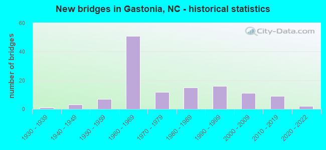
- New bridges - historical statistics
- 11930-1939
- 31940-1949
- 71950-1959
- 511960-1969
- 121970-1979
- 151980-1989
- 161990-1999
- 112000-2009
- 92010-2019
- 22020-2022

- Reconstructed bridges - Historical Statistics
- 21960-1969
- 31970-1979
- 21980-1989
- 31990-1999
- 12000-2009


- Bridge Condition - Deck
- 1.7%Very good
- 56.7%Good
- 30.0%Satisfactory
- 11.7%Fair

- Bridge Condition - Superstructure
- 5.0%Very good
- 56.7%Good
- 23.3%Satisfactory
- 13.3%Fair
- 1.7%Serious

- Bridge Condition - Substructure
- 5.0%Very good
- 41.7%Good
- 26.7%Satisfactory
- 25.0%Fair
- 1.7%Poor

- Bridge Condition - Channel
- 7.2%Very good
- 60.9%Good
- 23.2%Satisfactory
- 7.2%Fair
- 1.4%Poor

- Bridge Condition - Culverts
- 9.1%Very good
- 42.4%Good
- 33.3%Satisfactory
- 9.1%Fair
- 6.1%Poor
Find on map >> Show street view
Structure Number: 71011, Location: 0.8 MI. N. JCT. SR1621 (Lat: 35.391386, Lng: -81.277558), Route carried "on" structure: State highway 1620, Year Built: 2010, Status: Open, Structure Length: 4.02m (13.19ft), Average Daily Traffic: 190 (year 2000), Truck Traffic: 6%, Average Future Daily Traffic: 380 (year 2040), Design Load: HS 25 or greater, Features Intersected: BEAVERDAM CREEK
Minimum Vertical Clearance: 30+ m (98+ ft), Kilometerpoint: 0.000, Lanes on structure: 2, Owner: State Highway Agency, Approaching Roadway Width: 7.9m (25.9ft), Skew: 3 degrees, Material/Design: Prestressed concrete, Design/Construction: Slab, Number Of Spans In Main Unit: 3, Length of Maximum Span: 14.9m (48.9ft), Curb-To-Curb Width: 8.0m (26.2ft), Out-to-Out Width: 9.1m (29.9ft)
Condition: Deck: Good, Superstructure: Good, Substructure: Good, Channel: Good, Operating Rating: 82.5 metric tons, Method Used To Determine Operating Rating: Load Factor (LF), Inventory Rating: 49.8 metric tons, Method Used To Determine Inventory Rating: Load Factor (LF), Structural Evaluation: Better than present minimum criteria, Deck Geometry: Somewhat better than minimum adequacy, Waterway Adequacy: Better than present minimum criteria, Approach Roadway Alignment: Equal to present desirable criteria, Designated Inspection Frequency: Every 24 months, Inspection Date: June 2020, Deck Structure Type: Concrete Cast-file-Place, Wearing Surface/Protective System: Wearing Surface: Bituminous
Find on map >> Show street view
Structure Number: 710111, Location: 0.8 MI. N. JCT. SR1623 (Lat: 35.388947, Lng: -81.285017), Route carried "on" structure: State highway 1622, Year Built: 1954, Status: Temporarily open, Structure Length: 1.24m (4.07ft), Average Daily Traffic: 1,900 (year 2012), Truck Traffic: 6%, Average Future Daily Traffic: 3,800 (year 2040), Features Intersected: BEAVERDAM CREEK
Minimum Vertical Clearance: 30+ m (98+ ft), Kilometerpoint: 0.000, Lanes on structure: 2, Owner: State Highway Agency, Approaching Roadway Width: 5.4m (17.7ft), Material/Design: Steel continuous, Design/Construction: Stringer/Multi-beam, Number Of Spans In Main Unit: 2, Length of Maximum Span: 6.0m (19.7ft), Curb-To-Curb Width: 5.8m (19.0ft), Out-to-Out Width: 6.1m (20.0ft)
Condition: Deck: Good, Superstructure: Fair, Substructure: Fair, Channel: Good, Operating Rating: 54.4 metric tons, Method Used To Determine Operating Rating: Allowable Stress (AS), Inventory Rating: 39.0 metric tons, Method Used To Determine Inventory Rating: Allowable Stress (AS), Structural Evaluation: Somewhat better than minimum adequacy, Deck Geometry: High priority of replacement, Waterway Adequacy: Better than present minimum criteria, Approach Roadway Alignment: Equal to present desirable criteria, Designated Inspection Frequency: Every 24 months, Inspection Date: June 2020, Deck Structure Type: Wood or Timber, Wearing Surface/Protective System: Wearing Surface: Bituminous
Find on map >> Show street view
Structure Number: 710112, Location: 0.9 MI. N. JCT. SR1698 (Lat: 35.378153, Lng: -81.296044), Route carried "on" structure: State highway 1624, Year Built: 1985, Status: Open, Structure Length: 1.24m (4.07ft), Average Daily Traffic: 240 (year 2000), Truck Traffic: 6%, Average Future Daily Traffic: 480 (year 2040), Features Intersected: LITTLE BEAVERDAM CREEK
Minimum Vertical Clearance: 30+ m (98+ ft), Kilometerpoint: 0.000, Lanes on structure: 2, Owner: State Highway Agency, Approaching Roadway Width: 6.0m (19.7ft), Skew: 2 degrees, Material/Design: Steel, Design/Construction: Stringer/Multi-beam, Number Of Spans In Main Unit: 1, Length of Maximum Span: 12.1m (39.7ft), Curb-To-Curb Width: 7.1m (23.3ft), Out-to-Out Width: 7.3m (24.0ft)
Condition: Deck: Good, Superstructure: Good, Substructure: Good, Channel: Good, Operating Rating: 55.3 metric tons, Method Used To Determine Operating Rating: Load Factor (LF), Inventory Rating: 32.6 metric tons, Method Used To Determine Inventory Rating: Load Factor (LF), Structural Evaluation: Better than present minimum criteria, Deck Geometry: Meets minimum limits, Waterway Adequacy: Better than present minimum criteria, Approach Roadway Alignment: Equal to present desirable criteria, Designated Inspection Frequency: Every 24 months, Inspection Date: June 2020, Deck Structure Type: Wood or Timber, Wearing Surface/Protective System: Wearing Surface: Bituminous
Find on map >> Show street view
Structure Number: 710117, Location: 0.7 MI. N. JCT. NC274 (Lat: 35.280575, Lng: -81.217756), Route carried "on" structure: City street , Year Built: 1962, Status: Open, Structure Length: 7.68m (25.20ft), Average Daily Traffic: 2,800 (year 2012), Truck Traffic: 7%, Average Future Daily Traffic: 5,600 (year 2040), Design Load: H 15, Features Intersected: I85, Facility Carried by Structure: NORTHWEST BLVD
Minimum Vertical Clearance: 30+ m (98+ ft), Kilometerpoint: 0.000, Lanes on structure: 2, Lanes under structure: 6, Owner: State Highway Agency, Approaching Roadway Width: 6.0m (19.7ft), Skew: 2 degrees, Material/Design: Prestressed concrete, Design/Construction: Stringer/Multi-beam, Number Of Spans In Main Unit: 4, Length of Maximum Span: 19.8m (65.0ft), Curb or Sidewalk Widths: Left: 0.4m (1.3ft), Right: 0.4m (1.3ft), Curb-To-Curb Width: 8.5m (27.9ft), Out-to-Out Width: 10.1m (33.1ft)
Condition: Deck: Fair, Superstructure: Good, Substructure: Fair, Operating Rating: 81.6 metric tons, Method Used To Determine Operating Rating: Load Factor (LF), Inventory Rating: 42.6 metric tons, Method Used To Determine Inventory Rating: Load Factor (LF), Structural Evaluation: Somewhat better than minimum adequacy, Deck Geometry: Meets minimum limits, Underclear: High priority of corrective action, Approach Roadway Alignment: Equal to present desirable criteria, Designated Inspection Frequency: Every 24 months, Inspection Date: July 2020, Deck Structure Type: Concrete Cast-file-Place, Wearing Surface/Protective System: Wearing Surface: Monolithic Concrete
Find on map >> Show street view
Structure Number: 710118, Location: 0.14 MI. E. JCT. SR1355 (Lat: 35.283383, Lng: -81.209308), Route carried "on" structure: State highway 1327, Year Built: 1962, Status: Open, Structure Length: 7.22m (23.69ft), Average Daily Traffic: 1,500 (year 2014), Truck Traffic: 7%, Average Future Daily Traffic: 3,000 (year 2040), Design Load: HS 20+Mod, Features Intersected: I85
Minimum Vertical Clearance: 30+ m (98+ ft), Kilometerpoint: 0.000, Lanes on structure: 2, Lanes under structure: 6, Owner: State Highway Agency, Approaching Roadway Width: 8.5m (27.9ft), Skew: 2 degrees, Material/Design: Prestressed concrete, Design/Construction: Stringer/Multi-beam, Number Of Spans In Main Unit: 4, Length of Maximum Span: 18.2m (59.7ft), Curb or Sidewalk Widths: Left: 1.5m (4.9ft), Right: 1.5m (4.9ft), Curb-To-Curb Width: 8.5m (27.9ft), Out-to-Out Width: 12.3m (40.4ft)
Condition: Deck: Satisfactory, Superstructure: Satisfactory, Substructure: Satisfactory, Operating Rating: 89.8 metric tons, Method Used To Determine Operating Rating: Load Factor (LF), Inventory Rating: 55.3 metric tons, Method Used To Determine Inventory Rating: Load Factor (LF), Structural Evaluation: Equal to present minimum criteria, Deck Geometry: Somewhat better than minimum adequacy, Underclear: High priority of corrective action, Approach Roadway Alignment: Equal to present desirable criteria, Designated Inspection Frequency: Every 24 months, Inspection Date: October 2020, Deck Structure Type: Concrete Cast-file-Place, Wearing Surface/Protective System: Wearing Surface: Monolithic Concrete
Find on map >> Show street view
Structure Number: 710119, Location: 0.01 MI. S. JCT. SR1449 (Lat: 35.316353, Lng: -81.271594), Route carried "on" structure: State highway 1446, Year Built: 1984, Status: Open, Structure Length: 3.84m (12.60ft), Average Daily Traffic: 910 (year 2014), Truck Traffic: 6%, Average Future Daily Traffic: 1,820 (year 2040), Design Load: HS 20+Mod, Features Intersected: LONG CREEK
Minimum Vertical Clearance: 30+ m (98+ ft), Kilometerpoint: 0.000, Lanes on structure: 2, Owner: State Highway Agency, Approaching Roadway Width: 7.6m (24.9ft), Material/Design: Prestressed concrete, Design/Construction: Slab, Number Of Spans In Main Unit: 3, Length of Maximum Span: 13.4m (44.0ft), Curb-To-Curb Width: 7.3m (24.0ft), Out-to-Out Width: 8.2m (26.9ft)
Condition: Deck: Good, Superstructure: Good, Substructure: Good, Channel: Satisfactory, Operating Rating: 78.0 metric tons, Method Used To Determine Operating Rating: Load Factor (LF), Inventory Rating: 47.1 metric tons, Method Used To Determine Inventory Rating: Load Factor (LF), Structural Evaluation: Better than present minimum criteria, Deck Geometry: Meets minimum limits, Waterway Adequacy: Better than present minimum criteria, Approach Roadway Alignment: Equal to present desirable criteria, Designated Inspection Frequency: Every 24 months, Inspection Date: May 2020, Deck Structure Type: Concrete Precast Panels, Wearing Surface/Protective System: Wearing Surface: Bituminous
Find on map >> Show street view
Structure Number: 71012, Location: 1.5 MI. N. JCT. US29 (Lat: 35.283581, Lng: -81.187803), Route carried "on" structure: Interstate 85, Year Built: 1962, Year Reconstructed: 1994, Status: Open, Structure Length: 10.39m (34.09ft), Average Daily Traffic: 54,000 (year 2015), Truck Traffic: 16%, Average Future Daily Traffic: 108,000 (year 2040), Design Load: HS 20+Mod, Features Intersected: US321
Minimum Vertical Clearance: 30+ m (98+ ft), Kilometerpoint: 5.181, Lanes on structure: 8, Lanes under structure: 5, Base Highway Network: Yes (Inventory Route: 1, Subroute: 85), Owner: State Highway Agency, Approaching Roadway Width: 34.7m (113.8ft), Skew: 32 degrees, Material/Design: Steel, Design/Construction: Stringer/Multi-beam, Number Of Spans In Main Unit: 6, Length of Maximum Span: 22.5m (73.8ft), Curb-To-Curb Width: 35.6m (116.8ft), Out-to-Out Width: 37.5m (123.0ft)
Condition: Deck: Good, Superstructure: Good, Substructure: Good, Operating Rating: 37.1 metric tons, Method Used To Determine Operating Rating: Load Factor (LF), Inventory Rating: 22.6 metric tons, Method Used To Determine Inventory Rating: Load Factor (LF), Structural Evaluation: Somewhat better than minimum adequacy, Deck Geometry: Equal to present minimum criteria, Underclear: Meets minimum limits, Approach Roadway Alignment: Equal to present desirable criteria, Designated Inspection Frequency: Every 24 months, Inspection Date: October 2020, Deck Structure Type: Concrete Cast-file-Place, Wearing Surface/Protective System: Wearing Surface: Monolithic Concrete
Find on map >> Show street view
Structure Number: 710123, Location: 0.7 MI. E. JCT. SR1443 (Lat: 35.326431, Lng: -81.283636), Route carried "on" structure: State highway 1445, Year Built: 1976, Status: Posted for load, Structure Length: 2.80m (9.19ft), Average Daily Traffic: 190 (year 2012), Truck Traffic: 6%, Average Future Daily Traffic: 380 (year 2040), Features Intersected: UT TO LONG CREEK
Minimum Vertical Clearance: 30+ m (98+ ft), Kilometerpoint: 0.000, Lanes on structure: 2, Owner: State Highway Agency, Approaching Roadway Width: 6.0m (19.7ft), Skew: 3 degrees, Material/Design: Steel, Design/Construction: Stringer/Multi-beam, Number Of Spans In Main Unit: 3, Length of Maximum Span: 9.1m (29.9ft), Curb-To-Curb Width: 7.2m (23.6ft), Out-to-Out Width: 7.3m (24.0ft)
Condition: Deck: Satisfactory, Superstructure: Good, Substructure: Fair, Channel: Satisfactory, Operating Rating: 40.8 metric tons, Method Used To Determine Operating Rating: Load Factor (LF), Inventory Rating: 24.4 metric tons, Method Used To Determine Inventory Rating: Load Factor (LF), Structural Evaluation: Somewhat better than minimum adequacy, Deck Geometry: Meets minimum limits, Waterway Adequacy: Better than present minimum criteria, Approach Roadway Alignment: Equal to present desirable criteria, Bridge Posting: Required (Relationship of Operating Rating to Maximum Legal Load: 0.1 - 9.9% below), Designated Inspection Frequency: Every 24 months, Inspection Date: May 2020, Deck Structure Type: Corrugated Steel, Wearing Surface/Protective System: Wearing Surface: Bituminous
Find on map >> Show street view
Structure Number: 710124, Location: 0.1 MI. N. JCT. US321 (Lat: 35.283203, Lng: -81.186725), Route carried "on" structure: Interstate 85, Year Built: 1962, Year Reconstructed: 1995, Status: Open, Structure Length: 0.82m (2.69ft), Average Daily Traffic: 83,000 (year 2013), Truck Traffic: 16%, Average Future Daily Traffic: 166,000 (year 2040), Design Load: HS 20+Mod, Features Intersected: UT TO LONG CREEK
Minimum Vertical Clearance: 30+ m (98+ ft), Kilometerpoint: 5.212, Lanes on structure: 7, Base Highway Network: Yes (Inventory Route: 1, Subroute: 85), Owner: State Highway Agency, Approaching Roadway Width: 37.1m (121.7ft), Skew: 22 degrees, Material/Design: Concrete continuous, Design/Construction: Culvert, Number Of Spans In Main Unit: 3, Length of Maximum Span: 2.4m (7.9ft)
Condition: Channel: Good, Culverts: Satisfactory, Operating Rating: 41.7 metric tons, Method Used To Determine Operating Rating: Field evaluation and documented engineering judgment, Inventory Rating: 32.6 metric tons, Method Used To Determine Inventory Rating: Field evaluation and documented engineering judgment, Structural Evaluation: Equal to present minimum criteria, Waterway Adequacy: Somewhat better than minimum adequacy, Approach Roadway Alignment: Equal to present desirable criteria, Designated Inspection Frequency: Every 24 months, Inspection Date: October 2020
Find on map >> Show street view
Structure Number: 710125, Location: 1.4 MI. S. JCT. SR2275 (Lat: 35.282289, Lng: -81.183922), Route carried "on" structure: State highway 2278, Year Built: 1963, Status: Open, Structure Length: 8.65m (28.38ft), Average Daily Traffic: 6,100 (year 2014), Truck Traffic: 6%, Average Future Daily Traffic: 12,200 (year 2040), Design Load: HS 20+Mod, Features Intersected: I85
Minimum Vertical Clearance: 30+ m (98+ ft), Kilometerpoint: 0.000, Lanes on structure: 2, Lanes under structure: 6, Owner: State Highway Agency, Approaching Roadway Width: 7.6m (24.9ft), Skew: 2 degrees, Material/Design: Steel, Design/Construction: Stringer/Multi-beam, Number Of Spans In Main Unit: 4, Length of Maximum Span: 24.3m (79.7ft), Curb or Sidewalk Widths: Left: 1.5m (4.9ft), Right: 1.5m (4.9ft), Curb-To-Curb Width: 8.5m (27.9ft), Out-to-Out Width: 12.3m (40.4ft)
Condition: Deck: Fair, Superstructure: Satisfactory, Substructure: Satisfactory, Operating Rating: 67.1 metric tons, Method Used To Determine Operating Rating: Load Factor (LF), Inventory Rating: 39.9 metric tons, Method Used To Determine Inventory Rating: Load Factor (LF), Structural Evaluation: Equal to present minimum criteria, Deck Geometry: Meets minimum limits, Underclear: Equal to present minimum criteria, Approach Roadway Alignment: Equal to present desirable criteria, Designated Inspection Frequency: Every 24 months, Inspection Date: October 2020, Deck Structure Type: Concrete Cast-file-Place, Wearing Surface/Protective System: Wearing Surface: Monolithic Concrete
Find on map >> Show street view
Structure Number: 710126, Location: 1.3 MI. N. JCT. US321 (Lat: 35.277911, Lng: -81.166164), Route carried "on" structure: City street , Year Built: 1963, Status: Open, Structure Length: 7.95m (26.08ft), Average Daily Traffic: 4,300 (year 2012), Truck Traffic: 7%, Average Future Daily Traffic: 8,600 (year 2040), Design Load: HS 20+Mod, Features Intersected: I85, Facility Carried by Structure: N MODENA STREET
Minimum Vertical Clearance: 30+ m (98+ ft), Kilometerpoint: 0.000, Lanes on structure: 2, Lanes under structure: 6, Owner: State Highway Agency, Approaching Roadway Width: 8.5m (27.9ft), Skew: 3 degrees, Material/Design: Steel, Design/Construction: Stringer/Multi-beam, Number Of Spans In Main Unit: 4, Length of Maximum Span: 20.4m (66.9ft), Curb or Sidewalk Widths: Left: 1.5m (4.9ft), Right: 1.5m (4.9ft), Curb-To-Curb Width: 8.5m (27.9ft), Out-to-Out Width: 12.3m (40.4ft)
Condition: Deck: Satisfactory, Superstructure: Satisfactory, Substructure: Satisfactory, Operating Rating: 86.1 metric tons, Method Used To Determine Operating Rating: Load Factor (LF), Inventory Rating: 51.7 metric tons, Method Used To Determine Inventory Rating: Load Factor (LF), Structural Evaluation: Equal to present minimum criteria, Deck Geometry: Meets minimum limits, Underclear: High priority of corrective action, Approach Roadway Alignment: Equal to present minimum criteria, Designated Inspection Frequency: Every 24 months, Inspection Date: October 2020, Deck Structure Type: Concrete Cast-file-Place, Wearing Surface/Protective System: Wearing Surface: Monolithic Concrete
Find on map >> Show street view
Structure Number: 710127, Location: 0.2 MI. N. JCT. SR1444 (Lat: 35.337178, Lng: -81.295039), Route carried "on" structure: State highway 1443, Year Built: 1990, Status: Open, Structure Length: 1.49m (4.89ft), Average Daily Traffic: 600 (year 2012), Truck Traffic: 6%, Average Future Daily Traffic: 1,200 (year 2040), Design Load: HS 20+Mod, Features Intersected: UT TO LONG CREEK
Minimum Vertical Clearance: 30+ m (98+ ft), Kilometerpoint: 0.000, Lanes on structure: 2, Owner: State Highway Agency, Approaching Roadway Width: 6.0m (19.7ft), Skew: 4 degrees, Material/Design: Steel, Design/Construction: Culvert, Number Of Spans In Main Unit: 3, Length of Maximum Span: 2.7m (8.9ft)
Condition: Channel: Good, Culverts: Good, Operating Rating: 63.5 metric tons, Method Used To Determine Operating Rating: Load and Resistance Factor (LRFR), Inventory Rating: 48.9 metric tons, Method Used To Determine Inventory Rating: Load and Resistance Factor (LRFR), Structural Evaluation: Better than present minimum criteria, Waterway Adequacy: Better than present minimum criteria, Approach Roadway Alignment: Equal to present desirable criteria, Designated Inspection Frequency: Every 24 months, Inspection Date: August 2020
Find on map >> Show street view
Structure Number: 710133, Location: 0.5 MI. N. JCT. NC279 (Lat: 35.266472, Lng: -81.143161), Route carried "on" structure: City street , Year Built: 1960, Status: Open, Structure Length: 8.90m (29.20ft), Average Daily Traffic: 2,100 (year 2012), Truck Traffic: 7%, Average Future Daily Traffic: 4,200 (year 2040), Design Load: HS 20+Mod, Features Intersected: I85, Facility Carried by Structure: ABERDEEN BLVD.
Minimum Vertical Clearance: 30+ m (98+ ft), Kilometerpoint: 0.000, Lanes on structure: 2, Lanes under structure: 6, Owner: State Highway Agency, Approaching Roadway Width: 9.4m (30.8ft), Skew: 1 degrees, Material/Design: Steel, Design/Construction: Stringer/Multi-beam, Number Of Spans In Main Unit: 4, Length of Maximum Span: 22.8m (74.8ft), Curb or Sidewalk Widths: Left: 0.4m (1.3ft), Right: 0.4m (1.3ft), Curb-To-Curb Width: 8.5m (27.9ft), Out-to-Out Width: 10.1m (33.1ft)
Condition: Deck: Satisfactory, Superstructure: Satisfactory, Substructure: Satisfactory, Operating Rating: 79.8 metric tons, Method Used To Determine Operating Rating: Load Factor (LF), Inventory Rating: 47.1 metric tons, Method Used To Determine Inventory Rating: Load Factor (LF), Structural Evaluation: Equal to present minimum criteria, Deck Geometry: Meets minimum limits, Underclear: High priority of corrective action, Approach Roadway Alignment: Equal to present desirable criteria, Designated Inspection Frequency: Every 24 months, Inspection Date: August 2020, Deck Structure Type: Concrete Cast-file-Place, Wearing Surface/Protective System: Wearing Surface: Monolithic Concrete
Find on map >> Show street view
Structure Number: 710134, Location: 0.3 MI. E. JCT. US29 (Lat: 35.264789, Lng: -81.133664), Route carried "on" structure: State highway 2200, Year Built: 1990, Status: Open, Structure Length: 6.55m (21.49ft), Average Daily Traffic: 23,500 (year 2012), Truck Traffic: 12%, Average Future Daily Traffic: 47,000 (year 2040), Design Load: HS 20+Mod, Features Intersected: I-85
Minimum Vertical Clearance: 30+ m (98+ ft), Kilometerpoint: 0.000, Lanes on structure: 6, Lanes under structure: 6, Base Highway Network: Yes, Owner: State Highway Agency, Approaching Roadway Width: 23.1m (75.8ft), Skew: 1 degrees, Material/Design: Prestressed concrete, Design/Construction: Stringer/Multi-beam, Number Of Spans In Main Unit: 4, Length of Maximum Span: 19.2m (63.0ft), Curb or Sidewalk Widths: Left: 1.5m (4.9ft), Right: 1.5m (4.9ft), Curb-To-Curb Width: 23.1m (75.8ft), Out-to-Out Width: 27.0m (88.6ft)
Condition: Deck: Good, Superstructure: Good, Substructure: Good, Operating Rating: 71.6 metric tons, Method Used To Determine Operating Rating: Load Factor (LF), Inventory Rating: 40.8 metric tons, Method Used To Determine Inventory Rating: Load Factor (LF), Structural Evaluation: Better than present minimum criteria, Deck Geometry: Meets minimum limits, Underclear: High priority of corrective action, Approach Roadway Alignment: Equal to present desirable criteria, Designated Inspection Frequency: Every 24 months, Inspection Date: July 2020, Deck Structure Type: Concrete Cast-file-Place, Wearing Surface/Protective System: Wearing Surface: Monolithic Concrete, Deck Protection: Epoxy Coated Reinforcing
Find on map >> Show street view
Structure Number: 710139, Location: 0.25 MI. W. JCT. SR1334 (Lat: 35.292522, Lng: -81.219239), Route carried "on" structure: State highway 1327, Year Built: 1994, Status: Open, Structure Length: 0.79m (2.59ft), Average Daily Traffic: 1,400 (year 2012), Truck Traffic: 7%, Average Future Daily Traffic: 2,800 (year 2040), Design Load: HS 20+Mod, Features Intersected: UT TO LONG CREEK
Minimum Vertical Clearance: 30+ m (98+ ft), Kilometerpoint: 0.000, Lanes on structure: 2, Owner: State Highway Agency, Approaching Roadway Width: 7.0m (23.0ft), Material/Design: Concrete continuous, Design/Construction: Culvert, Number Of Spans In Main Unit: 2, Length of Maximum Span: 3.6m (11.8ft)
Condition: Channel: Good, Culverts: Good, Operating Rating: 44.4 metric tons, Method Used To Determine Operating Rating: Load and Resistance Factor (LRFR), Inventory Rating: 33.5 metric tons, Method Used To Determine Inventory Rating: Load and Resistance Factor (LRFR), Structural Evaluation: Better than present minimum criteria, Waterway Adequacy: Better than present minimum criteria, Approach Roadway Alignment: Equal to present desirable criteria, Designated Inspection Frequency: Every 24 months, Inspection Date: May 2020
Find on map >> Show street view
Structure Number: 71014, Location: 0.7 MI. S. JCT. SR1498 (Lat: 35.305356, Lng: -81.232644), Route carried "on" structure: State highway 1456, Year Built: 1957, Status: Posted for load, Structure Length: 3.90m (12.80ft), Average Daily Traffic: 2,100 (year 2012), Truck Traffic: 6%, Average Future Daily Traffic: 4,200 (year 2040), Design Load: H 15, Features Intersected: LONG CREEK
Minimum Vertical Clearance: 30+ m (98+ ft), Kilometerpoint: 0.000, Lanes on structure: 2, Owner: State Highway Agency, Approaching Roadway Width: 6.4m (21.0ft), Skew: 3 degrees, Material/Design: Steel, Design/Construction: Stringer/Multi-beam, Number Of Spans In Main Unit: 1, Number Of Approach Spans: 5, Length of Maximum Span: 12.1m (39.7ft), Curb or Sidewalk Widths: Left: 0.3m (1.0ft), Right: 0.3m (1.0ft), Curb-To-Curb Width: 7.3m (24.0ft), Out-to-Out Width: 8.6m (28.2ft)
Condition: Deck: Satisfactory, Superstructure: Satisfactory, Substructure: Fair, Channel: Satisfactory, Operating Rating: 32.6 metric tons, Method Used To Determine Operating Rating: Load Factor (LF), Inventory Rating: 6.3 metric tons, Method Used To Determine Inventory Rating: Load Factor (LF), Structural Evaluation: High priority of corrective action, Deck Geometry: High priority of replacement, Waterway Adequacy: Better than present minimum criteria, Approach Roadway Alignment: Equal to present desirable criteria, Bridge Posting: Required (Relationship of Operating Rating to Maximum Legal Load: 20.0 - 29.9% below), Designated Inspection Frequency: Every 24 months, Inspection Date: May 2020, Deck Structure Type: Concrete Cast-file-Place, Wearing Surface/Protective System: Wearing Surface: Monolithic Concrete
Find on map >> Show street view
Structure Number: 710147, Location: 0.3 MI. E. JCT. SR1620 (Lat: 35.380011, Lng: -81.270314), Route carried "on" structure: State highway 1621, Year Built: 1992, Status: Open, Structure Length: 0.67m (2.20ft), Average Daily Traffic: 340 (year 2000), Truck Traffic: 6%, Average Future Daily Traffic: 680 (year 2040), Design Load: HS 20+Mod, Features Intersected: UT TO BEAVERDAM CREEK
Minimum Vertical Clearance: 30+ m (98+ ft), Kilometerpoint: 0.000, Lanes on structure: 2, Owner: State Highway Agency, Approaching Roadway Width: 6.0m (19.7ft), Material/Design: Steel, Design/Construction: Culvert, Number Of Spans In Main Unit: 2, Length of Maximum Span: 2.7m (8.9ft)
Condition: Channel: Good, Culverts: Satisfactory, Operating Rating: 89.8 metric tons, Method Used To Determine Operating Rating: Load and Resistance Factor (LRFR), Inventory Rating: 89.8 metric tons, Method Used To Determine Inventory Rating: Load and Resistance Factor (LRFR), Structural Evaluation: Equal to present minimum criteria, Waterway Adequacy: Better than present minimum criteria, Approach Roadway Alignment: Equal to present desirable criteria, Designated Inspection Frequency: Every 24 months, Inspection Date: May 2020
Find on map >> Show street view
Structure Number: 710167, Location: .2MI.W.JCT.RANKIN LAKE RD (Lat: 35.289614, Lng: -81.192839), Route carried "on" structure: City street , Year Built: 2008, Status: Open, Structure Length: 3.20m (10.50ft), Average Daily Traffic: 1,000 (year 2005), Truck Traffic: 7%, Average Future Daily Traffic: 2,000 (year 2040), Design Load: HS 20, Features Intersected: KAGLOR BRANCH, Facility Carried by Structure: TULIP DRIVE
Minimum Vertical Clearance: 30+ m (98+ ft), Kilometerpoint: 0.000, Lanes on structure: 2, Owner: City or Municipal Highway Agency, Approaching Roadway Width: 10.6m (34.8ft), Material/Design: Prestressed concrete, Design/Construction: Slab, Number Of Spans In Main Unit: 3, Length of Maximum Span: 16.4m (53.8ft), Curb-To-Curb Width: 11.8m (38.7ft), Out-to-Out Width: 12.8m (42.0ft)
Condition: Deck: Good, Superstructure: Good, Substructure: Good, Channel: Good, Operating Rating: 51.7 metric tons, Method Used To Determine Operating Rating: Field evaluation and documented engineering judgment, Inventory Rating: 30.8 metric tons, Method Used To Determine Inventory Rating: Field evaluation and documented engineering judgment, Structural Evaluation: Better than present minimum criteria, Deck Geometry: Better than present minimum criteria, Waterway Adequacy: Better than present minimum criteria, Approach Roadway Alignment: Equal to present desirable criteria, Designated Inspection Frequency: Every 24 months, Inspection Date: June 2020, Deck Structure Type: Concrete Precast Panels, Wearing Surface/Protective System: Wearing Surface: Bituminous
Find on map >> Show street view
Structure Number: 710174, Location: 0.1 MI. E JCT.CHESTER ST. (Lat: 35.279067, Lng: -81.187061), Route carried "on" structure: City street , Year Built: 1965, Status: Open, Structure Length: 0.76m (2.49ft), Average Daily Traffic: 1,000 (year 1994), Truck Traffic: 7%, Average Future Daily Traffic: 2,000 (year 2040), Design Load: HS 20, Features Intersected: HIGHLAND CREEK, Facility Carried by Structure: CALDWELL STREET
Minimum Vertical Clearance: 30+ m (98+ ft), Kilometerpoint: 0.000, Lanes on structure: 2, Owner: City or Municipal Highway Agency, Approaching Roadway Width: 9.7m (31.8ft), Skew: 4 degrees, Material/Design: Steel, Design/Construction: Stringer/Multi-beam, Number Of Spans In Main Unit: 1, Length of Maximum Span: 7.0m (23.0ft), Curb or Sidewalk Widths: Left: 0.9m (3.0ft), Right: 0.2m (0.7ft), Curb-To-Curb Width: 9.1m (29.9ft), Out-to-Out Width: 10.9m (35.8ft)
Condition: Deck: Satisfactory, Superstructure: Satisfactory, Substructure: Fair, Channel: Good, Operating Rating: 89.8 metric tons, Method Used To Determine Operating Rating: Load Factor (LF), Inventory Rating: 55.3 metric tons, Method Used To Determine Inventory Rating: Load Factor (LF), Structural Evaluation: Somewhat better than minimum adequacy, Deck Geometry: Equal to present minimum criteria, Waterway Adequacy: Better than present minimum criteria, Approach Roadway Alignment: Equal to present desirable criteria, Designated Inspection Frequency: Every 24 months, Inspection Date: June 2020, Deck Structure Type: Concrete Cast-file-Place, Wearing Surface/Protective System: Wearing Surface: Bituminous
Find on map >> Show street view
Structure Number: 710183, Location: 0.1 MI.E.JCT.HARTFORD ST. (Lat: 35.238703, Lng: -81.217550), Route carried "on" structure: City street , Year Built: 1950, Status: Open, Structure Length: 0.70m (2.30ft), Average Daily Traffic: 300 (year 1994), Truck Traffic: 7%, Average Future Daily Traffic: 600 (year 2040), Design Load: HS 20, Features Intersected: BLACKWOOD CREEK, Facility Carried by Structure: OLD WEST LANE
Minimum Vertical Clearance: 30+ m (98+ ft), Kilometerpoint: 0.000, Lanes on structure: 2, Owner: City or Municipal Highway Agency, Approaching Roadway Width: 8.8m (28.9ft), Material/Design: Concrete continuous, Design/Construction: Culvert, Number Of Spans In Main Unit: 3, Length of Maximum Span: 2.1m (6.9ft), Curb or Sidewalk Widths: Left: 0.2m (0.7ft), Right: 1.5m (4.9ft), Curb-To-Curb Width: 9.1m (29.9ft), Out-to-Out Width: 11.2m (36.7ft)
Condition: Channel: Good, Culverts: Satisfactory, Operating Rating: 41.7 metric tons, Method Used To Determine Operating Rating: Field evaluation and documented engineering judgment, Inventory Rating: 32.6 metric tons, Method Used To Determine Inventory Rating: Field evaluation and documented engineering judgment, Structural Evaluation: Equal to present minimum criteria, Deck Geometry: Equal to present minimum criteria, Waterway Adequacy: Better than present minimum criteria, Approach Roadway Alignment: Equal to present desirable criteria, Designated Inspection Frequency: Every 24 months, Inspection Date: June 2020
Find on map >> Show street view
Structure Number: 71027, Location: 50 FT. W. JCT. NC7 (Lat: 35.280314, Lng: -81.149000), Route carried "on" structure: State highway 279, Year Built: 1940, Year Reconstructed: 1968, Status: Open, Structure Length: 2.86m (9.38ft), Average Daily Traffic: 22,000 (year 2012), Truck Traffic: 12%, Average Future Daily Traffic: 44,000 (year 2040), Design Load: H 15, Features Intersected: P&N RAILROAD
Minimum Vertical Clearance: 30+ m (98+ ft), Kilometerpoint: 0.000, Lanes on structure: 4, Base Highway Network: Yes (Inventory Route: 3, Subroute: 79), Owner: State Highway Agency, Approaching Roadway Width: 21.9m (71.9ft), Material/Design: Steel continuous, Design/Construction: Stringer/Multi-beam, Number Of Spans In Main Unit: 3, Length of Maximum Span: 12.1m (39.7ft), Curb or Sidewalk Widths: Left: 1.5m (4.9ft), Right: 1.5m (4.9ft), Curb-To-Curb Width: 18.9m (62.0ft), Out-to-Out Width: 22.7m (74.5ft)
Condition: Deck: Good, Superstructure: Fair, Substructure: Fair, Operating Rating: 55.3 metric tons, Method Used To Determine Operating Rating: Load Factor (LF), Inventory Rating: 32.6 metric tons, Method Used To Determine Inventory Rating: Load Factor (LF), Structural Evaluation: Somewhat better than minimum adequacy, Deck Geometry: Equal to present minimum criteria, Underclear: Meets minimum limits, Approach Roadway Alignment: Equal to present desirable criteria, Designated Inspection Frequency: Every 24 months, Inspection Date: August 2020, Deck Structure Type: Concrete Cast-file-Place, Wearing Surface/Protective System: Wearing Surface: Bituminous
Find on map >> Show street view
Structure Number: 710276, Location: 0.5 MI. N. JCT. SR1338 (Lat: 35.292136, Lng: -81.181853), Route carried "on" structure: State highway 2278, Year Built: 1981, Status: Open, Structure Length: 6.40m (21.00ft), Average Daily Traffic: 7,600 (year 2018), Truck Traffic: 6%, Average Future Daily Traffic: 15,200 (year 2040), Design Load: HS 20+Mod, Features Intersected: LONG CREEK
Minimum Vertical Clearance: 30+ m (98+ ft), Kilometerpoint: 0.000, Lanes on structure: 2, Owner: State Highway Agency, Approaching Roadway Width: 8.5m (27.9ft), Skew: 1 degrees, Material/Design: Prestressed concrete, Design/Construction: Stringer/Multi-beam, Number Of Spans In Main Unit: 3, Length of Maximum Span: 21.3m (69.9ft), Curb-To-Curb Width: 12.1m (39.7ft), Out-to-Out Width: 13.0m (42.7ft)
Condition: Deck: Satisfactory, Superstructure: Good, Substructure: Good, Channel: Satisfactory, Operating Rating: 89.8 metric tons, Method Used To Determine Operating Rating: Load Factor (LF), Inventory Rating: 35.3 metric tons, Method Used To Determine Inventory Rating: Load Factor (LF), Structural Evaluation: Better than present minimum criteria, Deck Geometry: Somewhat better than minimum adequacy, Waterway Adequacy: Better than present minimum criteria, Approach Roadway Alignment: Equal to present minimum criteria, Designated Inspection Frequency: Every 24 months, Inspection Date: June 2020, Deck Structure Type: Concrete Cast-file-Place, Wearing Surface/Protective System: Wearing Surface: Monolithic Concrete
Find on map >> Show street view
Structure Number: 710298, Location: 0.4 MI. N. JCT. SR1342 (Lat: 35.255450, Lng: -81.291014), Route carried "on" structure: State highway 1302, Year Built: 1962, Status: Open, Structure Length: 0.76m (2.49ft), Average Daily Traffic: 1,200 (year 2012), Truck Traffic: 7%, Average Future Daily Traffic: 2,400 (year 2040), Design Load: HS 15, Features Intersected: ABERNATHY CREEK
Minimum Vertical Clearance: 30+ m (98+ ft), Kilometerpoint: 0.000, Lanes on structure: 2, Owner: State Highway Agency, Approaching Roadway Width: 6.0m (19.7ft), Material/Design: Concrete continuous, Design/Construction: Culvert, Number Of Spans In Main Unit: 3, Length of Maximum Span: 2.4m (7.9ft)
Condition: Channel: Good, Culverts: Satisfactory, Operating Rating: 31.7 metric tons, Method Used To Determine Operating Rating: Field evaluation and documented engineering judgment, Inventory Rating: 24.4 metric tons, Method Used To Determine Inventory Rating: Field evaluation and documented engineering judgment, Structural Evaluation: Equal to present minimum criteria, Waterway Adequacy: Better than present minimum criteria, Approach Roadway Alignment: Equal to present desirable criteria, Designated Inspection Frequency: Every 24 months, Inspection Date: June 2020
Find on map >> Show street view
Structure Number: 710307, Location: 0.3 MI. W. JCT. US321 (Lat: 35.253664, Lng: -81.194458), Route carried "on" structure: State highway 2466, Year Built: 1970, Status: Open, Structure Length: 0.64m (2.10ft), Average Daily Traffic: 16,000 (year 2012), Truck Traffic: 12%, Average Future Daily Traffic: 32,000 (year 2040), Design Load: HS 20+Mod, Features Intersected: CATAWBA CREEK
Minimum Vertical Clearance: 30+ m (98+ ft), Kilometerpoint: 0.000, Lanes on structure: 5, Owner: State Highway Agency, Approaching Roadway Width: 18.2m (59.7ft), Skew: 4 degrees, Material/Design: Concrete continuous, Design/Construction: Culvert, Number Of Spans In Main Unit: 2, Length of Maximum Span: 2.1m (6.9ft)
Condition: Channel: Good, Culverts: Good, Operating Rating: 89.8 metric tons, Method Used To Determine Operating Rating: Load and Resistance Factor (LRFR), Inventory Rating: 78.0 metric tons, Method Used To Determine Inventory Rating: Load and Resistance Factor (LRFR), Structural Evaluation: Better than present minimum criteria, Waterway Adequacy: Better than present minimum criteria, Approach Roadway Alignment: Equal to present desirable criteria, Designated Inspection Frequency: Every 24 months, Inspection Date: July 2020
Find on map >> Show street view
Structure Number: 710312, Location: 0.2 MI. E. JCT. SR1447 (Lat: 35.338408, Lng: -81.278414), Route carried "on" structure: State highway 1446, Year Built: 1955, Status: Open, Structure Length: 0.97m (3.18ft), Average Daily Traffic: 500 (year 2012), Truck Traffic: 6%, Average Future Daily Traffic: 1,000 (year 2040), Design Load: HS 20+Mod, Features Intersected: UT TO LONG CREEK
Minimum Vertical Clearance: 30+ m (98+ ft), Kilometerpoint: 0.000, Lanes on structure: 2, Owner: State Highway Agency, Approaching Roadway Width: 5.4m (17.7ft), Skew: 4 degrees, Material/Design: Steel, Design/Construction: Culvert, Number Of Spans In Main Unit: 3, Length of Maximum Span: 2.1m (6.9ft)
Condition: Channel: Good, Culverts: Poor, Operating Rating: 89.8 metric tons, Method Used To Determine Operating Rating: Load and Resistance Factor (LRFR), Inventory Rating: 89.8 metric tons, Method Used To Determine Inventory Rating: Load and Resistance Factor (LRFR), Structural Evaluation: Meets minimum limits, Waterway Adequacy: Equal to present minimum criteria, Approach Roadway Alignment: Equal to present desirable criteria, Designated Inspection Frequency: Every 24 months, Inspection Date: May 2020
Find on map >> Show street view
Structure Number: 710314, Location: 0.4 MI. E. JCT. SR1303 (Lat: 35.250422, Lng: -81.299356), Route carried "on" structure: US 29, Year Built: 1982, Status: Open, Structure Length: 5.88m (19.29ft), Average Daily Traffic: 6,500 (year 2018), Truck Traffic: 12%, Average Future Daily Traffic: 13,000 (year 2040), Design Load: HS 20+Mod, Features Intersected: I85 SBL
Minimum Vertical Clearance: 30+ m (98+ ft), Kilometerpoint: 0.000, Lanes on structure: 3, Lanes under structure: 3, Base Highway Network: Yes (Inventory Route: 2, Subroute: 29), Owner: State Highway Agency, Approaching Roadway Width: 14.3m (46.9ft), Skew: 9 degrees, Material/Design: Steel, Design/Construction: Stringer/Multi-beam, Number Of Spans In Main Unit: 3, Length of Maximum Span: 32.9m (107.9ft), Curb-To-Curb Width: 14.7m (48.2ft), Out-to-Out Width: 15.6m (51.2ft)
Condition: Deck: Satisfactory, Superstructure: Satisfactory, Substructure: Fair, Operating Rating: 86.1 metric tons, Method Used To Determine Operating Rating: Load Factor (LF), Inventory Rating: 51.7 metric tons, Method Used To Determine Inventory Rating: Load Factor (LF), Structural Evaluation: Somewhat better than minimum adequacy, Deck Geometry: Somewhat better than minimum adequacy, Underclear: Somewhat better than minimum adequacy, Approach Roadway Alignment: Equal to present desirable criteria, Designated Inspection Frequency: Every 24 months, Inspection Date: October 2021, Deck Structure Type: Concrete Cast-file-Place, Wearing Surface/Protective System: Wearing Surface: Monolithic Concrete
Find on map >> Show street view
Structure Number: 710316, Location: 0.5 MI. S. JCT. US321 (Lat: 35.285736, Lng: -81.195861), Route carried "on" structure: Interstate 85, Year Built: 1962, Year Reconstructed: 1996, Status: Open, Structure Length: 0.88m (2.89ft), Average Daily Traffic: 83,000 (year 2013), Truck Traffic: 16%, Average Future Daily Traffic: 166,000 (year 2040), Design Load: HS 20+Mod, Features Intersected: KAGLOR BRANCH
Minimum Vertical Clearance: 30+ m (98+ ft), Kilometerpoint: 5.090, Lanes on structure: 6, Base Highway Network: Yes (Inventory Route: 1, Subroute: 85), Owner: State Highway Agency, Approaching Roadway Width: 32.6m (107.0ft), Skew: 33 degrees, Material/Design: Concrete continuous, Design/Construction: Culvert, Number Of Spans In Main Unit: 3, Length of Maximum Span: 2.4m (7.9ft)
Condition: Channel: Good, Culverts: Good, Operating Rating: 77.1 metric tons, Method Used To Determine Operating Rating: Load and Resistance Factor (LRFR), Inventory Rating: 58.9 metric tons, Method Used To Determine Inventory Rating: Load and Resistance Factor (LRFR), Structural Evaluation: Better than present minimum criteria, Waterway Adequacy: Better than present minimum criteria, Approach Roadway Alignment: Equal to present desirable criteria, Designated Inspection Frequency: Every 24 months, Inspection Date: September 2020
Find on map >> Show street view
Structure Number: 710319, Location: 0.4 MI. S. JCT. US29&US74 (Lat: 35.252078, Lng: -81.109617), Route carried "on" structure: State highway 2329, Year Built: 1977, Status: Open, Structure Length: 1.43m (4.69ft), Average Daily Traffic: 20,000 (year 2016), Truck Traffic: 6%, Average Future Daily Traffic: 40,000 (year 2040), Features Intersected: DUHARTS CREEK
Minimum Vertical Clearance: 30+ m (98+ ft), Kilometerpoint: 0.000, Lanes on structure: 2, Owner: State Highway Agency, Approaching Roadway Width: 10.6m (34.8ft), Material/Design: Steel, Design/Construction: Stringer/Multi-beam, Number Of Spans In Main Unit: 3, Length of Maximum Span: 6.4m (21.0ft), Curb or Sidewalk Widths: Left: 1.2m (3.9ft), Right: 0.0m, Curb-To-Curb Width: 10.0m (32.8ft), Out-to-Out Width: 12.1m (39.7ft)
Condition: Deck: Satisfactory, Superstructure: Fair, Substructure: Fair, Channel: Fair, Operating Rating: 69.8 metric tons, Method Used To Determine Operating Rating: Load Factor (LF), Inventory Rating: 41.7 metric tons, Method Used To Determine Inventory Rating: Load Factor (LF), Structural Evaluation: Somewhat better than minimum adequacy, Deck Geometry: Meets minimum limits, Waterway Adequacy: Better than present minimum criteria, Approach Roadway Alignment: Equal to present desirable criteria, Designated Inspection Frequency: Every 24 months, Inspection Date: August 2020, Deck Structure Type: Concrete Cast-file-Place, Wearing Surface/Protective System: Wearing Surface: Monolithic Concrete
Find on map >> Show street view
Structure Number: 71032, Location: 50 FT. W. JCT. SR1130 (Lat: 35.190464, Lng: -81.237694), Route carried "on" structure: State highway 1103, Year Built: 1957, Status: Open, Structure Length: 0.67m (2.20ft), Average Daily Traffic: 2,500 (year 2018), Truck Traffic: 6%, Average Future Daily Traffic: 5,000 (year 2040), Design Load: HS 20+Mod, Features Intersected: MCGILL BRANCH
Minimum Vertical Clearance: 30+ m (98+ ft), Kilometerpoint: 0.000, Lanes on structure: 2, Owner: State Highway Agency, Approaching Roadway Width: 6.7m (22.0ft), Skew: 3 degrees, Material/Design: Concrete continuous, Design/Construction: Culvert, Number Of Spans In Main Unit: 2, Length of Maximum Span: 2.7m (8.9ft)
Condition: Channel: Good, Culverts: Good, Operating Rating: 41.7 metric tons, Method Used To Determine Operating Rating: Field evaluation and documented engineering judgment, Inventory Rating: 32.6 metric tons, Method Used To Determine Inventory Rating: Field evaluation and documented engineering judgment, Structural Evaluation: Better than present minimum criteria, Waterway Adequacy: Better than present minimum criteria, Approach Roadway Alignment: Equal to present desirable criteria, Designated Inspection Frequency: Every 24 months, Inspection Date: July 2020
Find on map >> Show street view
Structure Number: 710321, Location: 0.1 MI. N. JCT. NC279 (Lat: 35.267722, Lng: -81.147058), Route carried "on" structure: Interstate 85, Year Built: 1963, Year Reconstructed: 1978, Status: Open, Structure Length: 0.70m (2.30ft), Average Daily Traffic: 109,000 (year 2013), Truck Traffic: 16%, Average Future Daily Traffic: 218,000 (year 2040), Design Load: HS 20+Mod, Features Intersected: DUHART'S CREEK
Minimum Vertical Clearance: 30+ m (98+ ft), Kilometerpoint: 6.004, Lanes on structure: 6, Base Highway Network: Yes (Inventory Route: 1, Subroute: 85), Owner: State Highway Agency, Approaching Roadway Width: 32.3m (106.0ft), Skew: 36 degrees, Material/Design: Concrete continuous, Design/Construction: Culvert, Number Of Spans In Main Unit: 1, Length of Maximum Span: 2.4m (7.9ft)
Condition: Channel: Good, Culverts: Fair, Operating Rating: 62.5 metric tons, Method Used To Determine Operating Rating: Load and Resistance Factor (LRFR), Inventory Rating: 48.0 metric tons, Method Used To Determine Inventory Rating: Load and Resistance Factor (LRFR), Structural Evaluation: Somewhat better than minimum adequacy, Waterway Adequacy: Better than present minimum criteria, Approach Roadway Alignment: Equal to present desirable criteria, Designated Inspection Frequency: Every 24 months, Underwater Inspection Frequency: Every 60 months, Inspection Date: August 2020, Underwater Inspection Date: August 2020
Find on map >> Show street view
Structure Number: 710336, Location: 0.5 MI. W. JCT. SR2278 (Lat: 35.306853, Lng: -81.187414), Route carried "on" structure: State highway 1336, Year Built: 1986, Status: Open, Structure Length: 7.49m (24.57ft), Average Daily Traffic: 4,500 (year 2014), Truck Traffic: 7%, Average Future Daily Traffic: 9,000 (year 2040), Design Load: HS 20+Mod, Features Intersected: US321
Minimum Vertical Clearance: 30+ m (98+ ft), Kilometerpoint: 0.000, Lanes on structure: 4, Lanes under structure: 6, Owner: State Highway Agency, Approaching Roadway Width: 15.8m (51.8ft), Skew: 23 degrees, Material/Design: Prestressed concrete, Design/Construction: Stringer/Multi-beam, Number Of Spans In Main Unit: 4, Length of Maximum Span: 25.9m (85.0ft), Curb-To-Curb Width: 17.6m (57.7ft), Out-to-Out Width: 18.4m (60.4ft)
Condition: Deck: Good, Superstructure: Good, Substructure: Satisfactory, Operating Rating: 78.9 metric tons, Method Used To Determine Operating Rating: Load Factor (LF), Inventory Rating: 31.7 metric tons, Method Used To Determine Inventory Rating: Load Factor (LF), Structural Evaluation: Equal to present minimum criteria, Deck Geometry: Somewhat better than minimum adequacy, Underclear: Somewhat better than minimum adequacy, Approach Roadway Alignment: Equal to present desirable criteria, Designated Inspection Frequency: Every 24 months, Inspection Date: May 2020, Deck Structure Type: Concrete Cast-file-Place, Wearing Surface/Protective System: Wearing Surface: Monolithic Concrete
Find on map >> Show street view
Structure Number: 71035, Location: .02 MI.S.JCT.NC7 (Lat: 35.265036, Lng: -81.181956), Route carried "on" structure: State highway 2278, Year Built: 1988, Status: Open, Structure Length: 5.24m (17.19ft), Average Daily Traffic: 5,400 (year 2018), Truck Traffic: 6%, Average Future Daily Traffic: 10,800 (year 2040), Design Load: HS 20+Mod, Features Intersected: SOUTHERN RAILROAD
Minimum Vertical Clearance: 30+ m (98+ ft), Kilometerpoint: 0.000, Lanes on structure: 4, Owner: State Highway Agency, Approaching Roadway Width: 11.8m (38.7ft), Material/Design: Prestressed concrete, Design/Construction: Stringer/Multi-beam, Number Of Spans In Main Unit: 3, Length of Maximum Span: 20.7m (67.9ft), Curb or Sidewalk Widths: Left: 3.3m (10.8ft), Right: 1.5m (4.9ft), Curb-To-Curb Width: 13.1m (43.0ft), Out-to-Out Width: 19.6m (64.3ft)
Condition: Deck: Good, Superstructure: Good, Substructure: Good, Operating Rating: 71.6 metric tons, Method Used To Determine Operating Rating: Load Factor (LF), Inventory Rating: 31.7 metric tons, Method Used To Determine Inventory Rating: Load Factor (LF), Structural Evaluation: Better than present minimum criteria, Deck Geometry: High priority of replacement, Underclear: Equal to present desirable criteria, Approach Roadway Alignment: Equal to present desirable criteria, Designated Inspection Frequency: Every 24 months, Inspection Date: October 2021, Deck Structure Type: Concrete Cast-file-Place, Wearing Surface/Protective System: Wearing Surface: Monolithic Concrete
Find on map >> Show street view
Structure Number: 710351, Location: 0.18 MI. N. JCT. US29&74 (Lat: 35.264772, Lng: -81.185711), Route carried "on" structure: US 321, Year Built: 1988, Status: Open, Structure Length: 4.78m (15.68ft), Average Daily Traffic: 7,900 (year 2014), Truck Traffic: 12%, Average Future Daily Traffic: 15,800 (year 2040), Design Load: HS 20+Mod, Features Intersected: SOUTHERN RAILWAY
Minimum Vertical Clearance: 30+ m (98+ ft), Kilometerpoint: 0.000, Lanes on structure: 3, Base Highway Network: Yes (Inventory Route: 2, Subroute: 21), Owner: State Highway Agency, Approaching Roadway Width: 11.8m (38.7ft), Material/Design: Prestressed concrete, Design/Construction: Stringer/Multi-beam, Number Of Spans In Main Unit: 3, Length of Maximum Span: 20.7m (67.9ft), Curb or Sidewalk Widths: Left: 1.5m (4.9ft), Right: 1.5m (4.9ft), Curb-To-Curb Width: 12.1m (39.7ft), Out-to-Out Width: 16.0m (52.5ft)
Condition: Deck: Satisfactory, Superstructure: Good, Substructure: Good, Operating Rating: 89.8 metric tons, Method Used To Determine Operating Rating: Load Factor (LF), Inventory Rating: 43.5 metric tons, Method Used To Determine Inventory Rating: Load Factor (LF), Structural Evaluation: Better than present minimum criteria, Deck Geometry: Meets minimum limits, Underclear: Better than present minimum criteria, Approach Roadway Alignment: Equal to present desirable criteria, Designated Inspection Frequency: Every 24 months, Inspection Date: August 2020, Deck Structure Type: Concrete Cast-file-Place, Wearing Surface/Protective System: Wearing Surface: Monolithic Concrete
Find on map >> Show street view
Structure Number: 710355, Location: 1.0 MI.E.JCT.US321 (Lat: 35.265414, Lng: -81.169117), Route carried "on" structure: State highway 7, Year Built: 1989, Status: Open, Structure Length: 4.57m (14.99ft), Average Daily Traffic: 16,000 (year 2012), Truck Traffic: 12%, Average Future Daily Traffic: 32,000 (year 2025), Design Load: HS 20+Mod, Features Intersected: SEABOARD COASTLINE RR
Minimum Vertical Clearance: 30+ m (98+ ft), Kilometerpoint: 0.000, Lanes on structure: 5, Base Highway Network: Yes (Inventory Route: 3, Subroute: 7), Owner: State Highway Agency, Approaching Roadway Width: 19.8m (65.0ft), Skew: 2 degrees, Material/Design: Prestressed concrete, Design/Construction: Stringer/Multi-beam, Number Of Spans In Main Unit: 3, Length of Maximum Span: 18.8m (61.7ft), Curb or Sidewalk Widths: Left: 1.5m (4.9ft), Right: 1.5m (4.9ft), Curb-To-Curb Width: 19.5m (64.0ft), Out-to-Out Width: 23.3m (76.4ft)
Condition: Deck: Good, Superstructure: Good, Substructure: Good, Operating Rating: 89.8 metric tons, Method Used To Determine Operating Rating: Load Factor (LF), Inventory Rating: 40.8 metric tons, Method Used To Determine Inventory Rating: Load Factor (LF), Structural Evaluation: Better than present minimum criteria, Deck Geometry: Meets minimum limits, Underclear: Better than present minimum criteria, Approach Roadway Alignment: Equal to present desirable criteria, Designated Inspection Frequency: Every 24 months, Inspection Date: August 2020, Deck Structure Type: Concrete Cast-file-Place, Wearing Surface/Protective System: Wearing Surface: Monolithic Concrete
Find on map >> Show street view
Structure Number: 710357, Location: 0.18 MI. N. JCT.US29,US74 (Lat: 35.264842, Lng: -81.177839), Route carried "on" structure: State highway 9907, Year Built: 1991, Status: Open, Structure Length: 6.06m (19.88ft), Average Daily Traffic: 9,600 (year 2014), Truck Traffic: 7%, Average Future Daily Traffic: 19,200 (year 2040), Design Load: HS 20+Mod, Features Intersected: SOUTHERN RAILROAD
Minimum Vertical Clearance: 30+ m (98+ ft), Kilometerpoint: 0.000, Lanes on structure: 5, Owner: State Highway Agency, Approaching Roadway Width: 19.5m (64.0ft), Material/Design: Steel, Design/Construction: Stringer/Multi-beam, Number Of Spans In Main Unit: 3, Length of Maximum Span: 24.6m (80.7ft), Curb or Sidewalk Widths: Left: 1.5m (4.9ft), Right: 1.5m (4.9ft), Curb-To-Curb Width: 19.5m (64.0ft), Out-to-Out Width: 23.3m (76.4ft)
Condition: Deck: Good, Superstructure: Good, Substructure: Good, Operating Rating: 89.8 metric tons, Method Used To Determine Operating Rating: Load Factor (LF), Inventory Rating: 57.1 metric tons, Method Used To Determine Inventory Rating: Load Factor (LF), Structural Evaluation: Better than present minimum criteria, Deck Geometry: Meets minimum limits, Underclear: Better than present minimum criteria, Approach Roadway Alignment: Equal to present desirable criteria, Designated Inspection Frequency: Every 24 months, Inspection Date: August 2020, Deck Structure Type: Concrete Cast-file-Place, Wearing Surface/Protective System: Wearing Surface: Monolithic Concrete
Find on map >> Show street view
Structure Number: 710381, Location: 0.18 MI. N. JCT.US29&74 (Lat: 35.264783, Lng: -81.187250), Route carried "on" structure: US 321, Year Built: 1989, Status: Open, Structure Length: 4.78m (15.68ft), Average Daily Traffic: 9,700 (year 2018), Truck Traffic: 12%, Average Future Daily Traffic: 19,400 (year 2040), Design Load: HS 20+Mod, Features Intersected: SOUTHERN RAILWAY
Minimum Vertical Clearance: 30+ m (98+ ft), Kilometerpoint: 0.000, Lanes on structure: 3, Base Highway Network: Yes (Inventory Route: 2, Subroute: 21), Owner: State Highway Agency, Approaching Roadway Width: 15.5m (50.9ft), Material/Design: Steel, Design/Construction: Stringer/Multi-beam, Number Of Spans In Main Unit: 3, Length of Maximum Span: 20.7m (67.9ft), Curb or Sidewalk Widths: Left: 1.5m (4.9ft), Right: 1.5m (4.9ft), Curb-To-Curb Width: 12.1m (39.7ft), Out-to-Out Width: 16.0m (52.5ft)
Condition: Deck: Satisfactory, Superstructure: Good, Substructure: Good, Operating Rating: 88.9 metric tons, Method Used To Determine Operating Rating: Load Factor (LF), Inventory Rating: 53.5 metric tons, Method Used To Determine Inventory Rating: Load Factor (LF), Structural Evaluation: Better than present minimum criteria, Deck Geometry: Meets minimum limits, Underclear: Equal to present desirable criteria, Approach Roadway Alignment: Equal to present desirable criteria, Designated Inspection Frequency: Every 24 months, Inspection Date: August 2020, Deck Structure Type: Concrete Cast-file-Place, Wearing Surface/Protective System: Wearing Surface: Monolithic Concrete
Find on map >> Show street view
Structure Number: 710388, Location: 0.8 MI. E. JCT. US321 (Lat: 35.231678, Lng: -81.180114), Route carried "on" structure: State highway 1255, Year Built: 1997, Status: Open, Structure Length: 0.64m (2.10ft), Average Daily Traffic: 11,000 (year 2012), Truck Traffic: 6%, Average Future Daily Traffic: 22,000 (year 2040), Design Load: HS 20+Mod, Features Intersected: UT TO CATAWBA CREEK
Minimum Vertical Clearance: 30+ m (98+ ft), Kilometerpoint: 0.000, Lanes on structure: 2, Owner: State Highway Agency, Approaching Roadway Width: 17.0m (55.8ft), Skew: 5 degrees, Material/Design: Concrete continuous, Design/Construction: Culvert, Number Of Spans In Main Unit: 2, Length of Maximum Span: 3.0m (9.8ft)
Condition: Channel: Good, Culverts: Satisfactory, Operating Rating: 89.8 metric tons, Method Used To Determine Operating Rating: Load and Resistance Factor (LRFR), Inventory Rating: 79.8 metric tons, Method Used To Determine Inventory Rating: Load and Resistance Factor (LRFR), Structural Evaluation: Equal to present minimum criteria, Waterway Adequacy: Better than present minimum criteria, Approach Roadway Alignment: Equal to present desirable criteria, Designated Inspection Frequency: Every 24 months, Inspection Date: August 2020
Find on map >> Show street view
Structure Number: 710421, Location: .1 MI.E.JCT.OAKWOOD ST. (Lat: 35.273669, Lng: -81.201769), Route carried "on" structure: City street , Year Built: 2011, Status: Open, Structure Length: 0.64m (2.10ft), Average Daily Traffic: 1,400 (year 2012), Truck Traffic: 7%, Average Future Daily Traffic: 2,800 (year 2040), Design Load: HS 20+Mod, Features Intersected: KAYLOR BRANCH, Facility Carried by Structure: W. DAVIDSON AVE.
Minimum Vertical Clearance: 30+ m (98+ ft), Kilometerpoint: 0.000, Lanes on structure: 2, Owner: City or Municipal Highway Agency, Approaching Roadway Width: 8.8m (28.9ft), Skew: 2 degrees, Material/Design: Concrete continuous, Design/Construction: Culvert, Number Of Spans In Main Unit: 2, Length of Maximum Span: 3.0m (9.8ft)
Condition: Channel: Good, Culverts: Good, Operating Rating: 41.7 metric tons, Method Used To Determine Operating Rating: Field evaluation and documented engineering judgment, Inventory Rating: 32.6 metric tons, Method Used To Determine Inventory Rating: Field evaluation and documented engineering judgment, Structural Evaluation: Better than present minimum criteria, Waterway Adequacy: Better than present minimum criteria, Approach Roadway Alignment: Equal to present desirable criteria, Designated Inspection Frequency: Every 24 months, Inspection Date: June 2020
Find on map >> Show street view
Structure Number: 710422, Location: 0.5 MI. E. JCT. NC274 (Lat: 35.237411, Lng: -81.163961), Route carried "on" structure: State highway 1255, Year Built: 1999, Status: Open, Structure Length: 6.49m (21.29ft), Average Daily Traffic: 8,250 (year 2018), Truck Traffic: 6%, Average Future Daily Traffic: 16,500 (year 2040), Design Load: HS 20+Mod, Features Intersected: CATAWBA CRK/PED.W
Minimum Vertical Clearance: 30+ m (98+ ft), Kilometerpoint: 0.000, Lanes on structure: 2, Owner: State Highway Agency, Approaching Roadway Width: 8.5m (27.9ft), Skew: 13 degrees, Material/Design: Prestressed concrete, Design/Construction: Stringer/Multi-beam, Number Of Spans In Main Unit: 3, Length of Maximum Span: 21.0m (68.9ft), Curb or Sidewalk Widths: Left: 0.0m, Right: 1.5m (4.9ft), Curb-To-Curb Width: 8.5m (27.9ft), Out-to-Out Width: 10.9m (35.8ft)
Condition: Deck: Good, Superstructure: Good, Substructure: Good, Channel: Satisfactory, Operating Rating: 89.8 metric tons, Method Used To Determine Operating Rating: Load Factor (LF), Inventory Rating: 39.9 metric tons, Method Used To Determine Inventory Rating: Load Factor (LF), Structural Evaluation: Better than present minimum criteria, Deck Geometry: High priority of corrective action, Waterway Adequacy: Better than present minimum criteria, Approach Roadway Alignment: Equal to present desirable criteria, Designated Inspection Frequency: Every 24 months, Inspection Date: June 2020, Deck Structure Type: Concrete Cast-file-Place, Wearing Surface/Protective System: Wearing Surface: Monolithic Concrete, Deck Protection: Epoxy Coated Reinforcing
Find on map >> Show street view
Structure Number: 710423, Location: 0.5 MI. E. JCT. NC274 (Lat: 35.237358, Lng: -81.163825), Route carried "on" structure: State highway 1255, Year Built: 1996, Status: Open, Structure Length: 6.49m (21.29ft), Average Daily Traffic: 8,250 (year 2018), Truck Traffic: 6%, Average Future Daily Traffic: 16,500 (year 2040), Design Load: HS 20+Mod, Features Intersected: CATAWBA CREEK/PED.WALKWA
Minimum Vertical Clearance: 30+ m (98+ ft), Kilometerpoint: 0.000, Lanes on structure: 2, Owner: State Highway Agency, Approaching Roadway Width: 8.5m (27.9ft), Skew: 13 degrees, Material/Design: Prestressed concrete, Design/Construction: Stringer/Multi-beam, Number Of Spans In Main Unit: 3, Length of Maximum Span: 21.0m (68.9ft), Curb-To-Curb Width: 8.5m (27.9ft), Out-to-Out Width: 9.4m (30.8ft)
Condition: Deck: Good, Superstructure: Good, Substructure: Good, Channel: Satisfactory, Operating Rating: 41.7 metric tons, Method Used To Determine Operating Rating: Load Factor (LF), Inventory Rating: 32.6 metric tons, Method Used To Determine Inventory Rating: Load Factor (LF), Structural Evaluation: Better than present minimum criteria, Deck Geometry: High priority of corrective action, Waterway Adequacy: Better than present minimum criteria, Approach Roadway Alignment: Equal to present desirable criteria, Designated Inspection Frequency: Every 24 months, Inspection Date: June 2020, Deck Structure Type: Concrete Cast-file-Place, Wearing Surface/Protective System: Wearing Surface: Monolithic Concrete
Find on map >> Show street view
Structure Number: 710432, Location: 0.1 MI. E. JCT. SR2200 (Lat: 35.227583, Lng: -81.130178), Route carried "on" structure: State highway 2446, Year Built: 2002, Status: Open, Structure Length: 5.60m (18.37ft), Average Daily Traffic: 8,900 (year 2012), Truck Traffic: 6%, Average Future Daily Traffic: 17,800 (year 2040), Design Load: HS 20+Mod, Features Intersected: CATAWBA CREEK
Minimum Vertical Clearance: 30+ m (98+ ft), Kilometerpoint: 0.000, Lanes on structure: 4, Owner: State Highway Agency, Approaching Roadway Width: 17.0m (55.8ft), Skew: 22 degrees, Material/Design: Prestressed concrete, Design/Construction: Stringer/Multi-beam, Number Of Spans In Main Unit: 3, Length of Maximum Span: 20.1m (65.9ft), Curb or Sidewalk Widths: Left: 1.5m (4.9ft), Right: 1.5m (4.9ft), Curb-To-Curb Width: 20.7m (67.9ft), Out-to-Out Width: 24.5m (80.4ft)
Condition: Deck: Good, Superstructure: Good, Substructure: Good, Channel: Satisfactory, Operating Rating: 64.4 metric tons, Method Used To Determine Operating Rating: Load Factor (LF), Inventory Rating: 22.6 metric tons, Method Used To Determine Inventory Rating: Load Factor (LF), Structural Evaluation: Somewhat better than minimum adequacy, Deck Geometry: Superior to present desirable criteria, Waterway Adequacy: Better than present minimum criteria, Approach Roadway Alignment: Equal to present desirable criteria, Designated Inspection Frequency: Every 24 months, Inspection Date: August 2020, Deck Structure Type: Concrete Cast-file-Place, Wearing Surface/Protective System: Wearing Surface: Monolithic Concrete, Deck Protection: Epoxy Coated Reinforcing
Find on map >> Show street view
Structure Number: 710435, Location: 0.03 MI. W. JCT. SR3217 (Lat: 35.231047, Lng: -81.134986), Route carried "on" structure: State highway 2200, Year Built: 2003, Status: Open, Structure Length: 1.46m (4.79ft), Average Daily Traffic: 8,700 (year 2018), Truck Traffic: 7%, Average Future Daily Traffic: 17,400 (year 2040), Design Load: HS 20+Mod, Features Intersected: CATAWBA CREEK
Minimum Vertical Clearance: 30+ m (98+ ft), Kilometerpoint: 0.000, Lanes on structure: 5, Owner: State Highway Agency, Approaching Roadway Width: 20.7m (67.9ft), Skew: 2 degrees, Material/Design: Concrete continuous, Design/Construction: Culvert, Number Of Spans In Main Unit: 4, Length of Maximum Span: 3.0m (9.8ft)
Condition: Channel: Satisfactory, Culverts: Satisfactory, Operating Rating: 41.7 metric tons, Method Used To Determine Operating Rating: Field evaluation and documented engineering judgment, Inventory Rating: 32.6 metric tons, Method Used To Determine Inventory Rating: Field evaluation and documented engineering judgment, Structural Evaluation: Equal to present minimum criteria, Waterway Adequacy: Equal to present minimum criteria, Approach Roadway Alignment: Equal to present desirable criteria, Designated Inspection Frequency: Every 24 months, Inspection Date: October 2021
Find on map >> Show street view
Structure Number: 71044, Location: 0.05 MI. N. JCT. US29/74 (Lat: 35.261731, Lng: -81.133475), Route carried "on" structure: State highway 2200, Year Built: 1970, Status: Open, Structure Length: 0.79m (2.59ft), Average Daily Traffic: 20,000 (year 2016), Truck Traffic: 12%, Average Future Daily Traffic: 40,000 (year 2040), Design Load: HS 20+Mod, Features Intersected: DUHART`S CREEK
Minimum Vertical Clearance: 30+ m (98+ ft), Kilometerpoint: 0.000, Lanes on structure: 5, Owner: State Highway Agency, Approaching Roadway Width: 22.8m (74.8ft), Skew: 1 degrees, Material/Design: Concrete continuous, Design/Construction: Culvert, Number Of Spans In Main Unit: 3, Length of Maximum Span: 2.4m (7.9ft)
Condition: Channel: Good, Culverts: Satisfactory, Operating Rating: 41.7 metric tons, Method Used To Determine Operating Rating: Field evaluation and documented engineering judgment, Inventory Rating: 32.6 metric tons, Method Used To Determine Inventory Rating: Field evaluation and documented engineering judgment, Structural Evaluation: Equal to present minimum criteria, Waterway Adequacy: Better than present minimum criteria, Approach Roadway Alignment: Equal to present desirable criteria, Designated Inspection Frequency: Every 24 months, Inspection Date: May 2021