Bridge Statistics for Gastonia, North Carolina (NC)
Condition, Traffic, Stress, Structural Evaluation, Project Costs
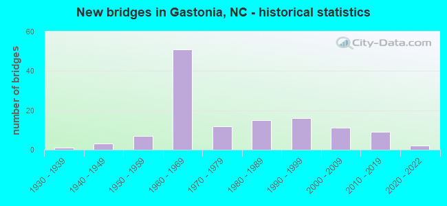
- New bridges - historical statistics
- 11930-1939
- 31940-1949
- 71950-1959
- 511960-1969
- 121970-1979
- 151980-1989
- 161990-1999
- 112000-2009
- 92010-2019
- 22020-2022

- Reconstructed bridges - Historical Statistics
- 21960-1969
- 31970-1979
- 21980-1989
- 31990-1999
- 12000-2009


- Bridge Condition - Deck
- 1.7%Very good
- 56.7%Good
- 30.0%Satisfactory
- 11.7%Fair

- Bridge Condition - Superstructure
- 5.0%Very good
- 56.7%Good
- 23.3%Satisfactory
- 13.3%Fair
- 1.7%Serious

- Bridge Condition - Substructure
- 5.0%Very good
- 41.7%Good
- 26.7%Satisfactory
- 25.0%Fair
- 1.7%Poor

- Bridge Condition - Channel
- 7.2%Very good
- 60.9%Good
- 23.2%Satisfactory
- 7.2%Fair
- 1.4%Poor

- Bridge Condition - Culverts
- 9.1%Very good
- 42.4%Good
- 33.3%Satisfactory
- 9.1%Fair
- 6.1%Poor
Find on map >> Show street view
Structure Number: 710441, Location: .1MI.N.CATAWBA HILLS DR. (Lat: 35.213889, Lng: -81.109111), Route carried "on" structure: Other road , Year Built: 2005, Status: Open, Structure Length: 1.06m (3.48ft), Average Daily Traffic: 900 (year 2001), Truck Traffic: 7%, Average Future Daily Traffic: 1,800 (year 2040), Design Load: HL 93, Features Intersected: UT TO CATAWBA CREEK, Facility Carried by Structure: BROADVIEW LANE
Minimum Vertical Clearance: 30+ m (98+ ft), Kilometerpoint: 0.000, Lanes on structure: 2, Owner: City or Municipal Highway Agency, Approaching Roadway Width: 7.9m (25.9ft), Material/Design: Prestressed concrete, Design/Construction: Slab, Number Of Spans In Main Unit: 1, Length of Maximum Span: 10.3m (33.8ft), Curb or Sidewalk Widths: Left: 1.6m (5.2ft), Right: 0.0m, Curb-To-Curb Width: 8.5m (27.9ft), Out-to-Out Width: 10.9m (35.8ft)
Condition: Deck: Good, Superstructure: Good, Substructure: Good, Channel: Good, Operating Rating: 89.8 metric tons, Method Used To Determine Operating Rating: Load and Resistance Factor (LRFR), Inventory Rating: 74.3 metric tons, Method Used To Determine Inventory Rating: Load and Resistance Factor (LRFR), Structural Evaluation: Better than present minimum criteria, Deck Geometry: Somewhat better than minimum adequacy, Waterway Adequacy: Better than present minimum criteria, Approach Roadway Alignment: Equal to present desirable criteria, Designated Inspection Frequency: Every 24 months, Inspection Date: June 2020, Deck Structure Type: Concrete Precast Panels, Wearing Surface/Protective System: Wearing Surface: Bituminous
Find on map >> Show street view
Structure Number: 710442, Location: .1MI.S.JCT.HOFFMAN ROAD (Lat: 35.228750, Lng: -81.125750), Route carried "on" structure: City street , Year Built: 2012, Status: Open, Structure Length: 0.67m (2.20ft), Average Daily Traffic: 300 (year 2012), Average Future Daily Traffic: 600 (year 2040), Design Load: HS 20+Mod, Features Intersected: UT TO CATAWBA CREEK, Facility Carried by Structure: LEONARD DRIVE
Minimum Vertical Clearance: 30+ m (98+ ft), Kilometerpoint: 0.000, Lanes on structure: 2, Owner: City or Municipal Highway Agency, Approaching Roadway Width: 8.5m (27.9ft), Material/Design: Prestressed concrete, Design/Construction: Culvert, Number Of Spans In Main Unit: 2, Length of Maximum Span: 3.0m (9.8ft), Curb or Sidewalk Widths: Left: 1.2m (3.9ft), Right: 1.2m (3.9ft)
Condition: Channel: Good, Culverts: Good, Operating Rating: 41.7 metric tons, Method Used To Determine Operating Rating: Field evaluation and documented engineering judgment, Inventory Rating: 32.6 metric tons, Method Used To Determine Inventory Rating: Field evaluation and documented engineering judgment, Structural Evaluation: Better than present minimum criteria, Waterway Adequacy: Better than present minimum criteria, Approach Roadway Alignment: Equal to present desirable criteria, Designated Inspection Frequency: Every 24 months, Inspection Date: June 2020
Find on map >> Show street view
Structure Number: 710443, Location: .3 MI.W.JCT.COX ROAD (Lat: 35.257944, Lng: -81.130056), Route carried "on" structure: City street , Year Built: 2012, Status: Open, Structure Length: 3.04m (9.97ft), Average Daily Traffic: 1,500 (year 2012), Truck Traffic: 7%, Average Future Daily Traffic: 3,000 (year 2040), Design Load: HS 20+Mod, Features Intersected: DUHARTS CREEK, Facility Carried by Structure: GASTONIA MALL DRIV
Minimum Vertical Clearance: 30+ m (98+ ft), Kilometerpoint: 0.000, Lanes on structure: 3, Owner: City or Municipal Highway Agency, Approaching Roadway Width: 12.1m (39.7ft), Material/Design: Steel, Design/Construction: Culvert, Number Of Spans In Main Unit: 2, Length of Maximum Span: 14.6m (47.9ft)
Condition: Channel: Good, Culverts: Good, Operating Rating: 41.7 metric tons, Method Used To Determine Operating Rating: Field evaluation and documented engineering judgment, Inventory Rating: 32.6 metric tons, Method Used To Determine Inventory Rating: Field evaluation and documented engineering judgment, Structural Evaluation: Better than present minimum criteria, Waterway Adequacy: Better than present minimum criteria, Approach Roadway Alignment: Equal to present minimum criteria, Designated Inspection Frequency: Every 24 months, Inspection Date: June 2020
Find on map >> Show street view
Structure Number: 710445, Location: 0.3 MILES N. JCT. U.S. 32 (Lat: 35.282433, Lng: -81.186717), Route carried "on" structure: Ramp Interstate 85, Year Built: 2021, Status: Open, Structure Length: 0.85m (2.79ft), Average Daily Traffic: 28,250 (year 2019), Truck Traffic: 16%, Average Future Daily Traffic: 56,500 (year 2040), Design Load: HL 93, Features Intersected: CREEK
Minimum Vertical Clearance: 30+ m (98+ ft), Kilometerpoint: 0.000, Lanes on structure: 2, Base Highway Network: Yes (Inventory Route: 1, Subroute: 85), Owner: State Highway Agency, Approaching Roadway Width: 13.4m (44.0ft), Skew: 2 degrees, Material/Design: Concrete continuous, Design/Construction: Culvert, Number Of Spans In Main Unit: 3, Length of Maximum Span: 2.4m (7.9ft)
Condition: Channel: Very good, Culverts: Very good, Operating Rating: 73.4 metric tons, Method Used To Determine Operating Rating: Load and Resistance Factor (LRFR), Inventory Rating: 56.2 metric tons, Method Used To Determine Inventory Rating: Load and Resistance Factor (LRFR), Structural Evaluation: Equal to present desirable criteria, Waterway Adequacy: Equal to present desirable criteria, Approach Roadway Alignment: Equal to present minimum criteria, Designated Inspection Frequency: Every 24 months, Inspection Date: November 2021
Find on map >> Show street view
Structure Number: 710446, Location: 0.025 MILE W. OF SR-2300 (Lat: 35.289467, Lng: -81.183883), Route carried "on" structure: City street , Year Built: 2021, Status: Open, Structure Length: 0.73m (2.40ft), Average Daily Traffic: 500 (year 2014), Truck Traffic: 7%, Average Future Daily Traffic: 1,000 (year 2040), Design Load: HL 93, Features Intersected: CREEK, Facility Carried by Structure: BULB STREET
Minimum Vertical Clearance: 30+ m (98+ ft), Kilometerpoint: 0.000, Lanes on structure: 2, Owner: State Highway Agency, Approaching Roadway Width: 8.2m (26.9ft), Material/Design: Concrete, Design/Construction: Culvert, Number Of Spans In Main Unit: 1, Length of Maximum Span: 7.3m (24.0ft)
Condition: Channel: Very good, Culverts: Very good, Operating Rating: 89.8 metric tons, Method Used To Determine Operating Rating: Load and Resistance Factor (LRFR), Inventory Rating: 89.8 metric tons, Method Used To Determine Inventory Rating: Load and Resistance Factor (LRFR), Structural Evaluation: Equal to present desirable criteria, Waterway Adequacy: Equal to present desirable criteria, Approach Roadway Alignment: Equal to present desirable criteria, Designated Inspection Frequency: Every 24 months, Inspection Date: November 2021
Find on map >> Show street view
Structure Number: 710453, Location: 0.5 MI.N.OF JCT.W/BETHESD (Lat: 35.235222, Lng: -81.103417), Route carried "on" structure: City street , Year Built: 2017, Status: Open, Structure Length: 0.97m (3.18ft), Average Daily Traffic: 5,500 (year 2014), Truck Traffic: 7%, Average Future Daily Traffic: 11,000 (year 2040), Design Load: HS 20+Mod, Features Intersected: UT TO OAK LAKE, Facility Carried by Structure: CYPRESS OAK LANE
Minimum Vertical Clearance: 30+ m (98+ ft), Kilometerpoint: 0.000, Lanes on structure: 2, Owner: City or Municipal Highway Agency, Approaching Roadway Width: 8.5m (27.9ft), Material/Design: Concrete, Design/Construction: Culvert, Number Of Spans In Main Unit: 1, Length of Maximum Span: 9.7m (31.8ft)
Condition: Channel: Good, Culverts: Good, Operating Rating: 41.7 metric tons, Method Used To Determine Operating Rating: Field evaluation and documented engineering judgment, Inventory Rating: 32.6 metric tons, Method Used To Determine Inventory Rating: Field evaluation and documented engineering judgment, Structural Evaluation: Better than present minimum criteria, Waterway Adequacy: Better than present minimum criteria, Approach Roadway Alignment: Equal to present desirable criteria, Designated Inspection Frequency: Every 24 months, Inspection Date: June 2020
Find on map >> Show street view
Structure Number: 710454, Location: 0.5MI E.OF JCT W/GASTON D (Lat: 35.204639, Lng: -81.126306), Route carried "on" structure: City street , Year Built: 2017, Status: Open, Structure Length: 1.79m (5.87ft), Average Daily Traffic: 4,700 (year 2016), Truck Traffic: 7%, Average Future Daily Traffic: 9,400 (year 2040), Design Load: HS 20+Mod, Features Intersected: CREEK, Facility Carried by Structure: KINMERE DR
Minimum Vertical Clearance: 30+ m (98+ ft), Kilometerpoint: 0.000, Lanes on structure: 2, Owner: City or Municipal Highway Agency, Approaching Roadway Width: 7.9m (25.9ft), Skew: 2 degrees, Material/Design: Concrete continuous, Design/Construction: Culvert, Number Of Spans In Main Unit: 4, Length of Maximum Span: 3.6m (11.8ft)
Condition: Channel: Good, Culverts: Good, Operating Rating: 41.7 metric tons, Method Used To Determine Operating Rating: Field evaluation and documented engineering judgment, Inventory Rating: 32.6 metric tons, Method Used To Determine Inventory Rating: Field evaluation and documented engineering judgment, Structural Evaluation: Better than present minimum criteria, Waterway Adequacy: Better than present minimum criteria, Approach Roadway Alignment: Equal to present desirable criteria, Designated Inspection Frequency: Every 24 months, Inspection Date: June 2020
Find on map >> Show street view
Structure Number: 710002, Location: 0.5 MI. W. JCT. US29/74 (Lat: 35.268769, Lng: -81.149486), Route carried "under" structure: Interstate 85, Year Built: 1963, Structure Length: 0. m, Average Daily Traffic: 54,250 (year 2013), Truck Traffic: 16%, Features Intersected: NC279
Minimum Vertical Clearance: 4.92m (16.14ft), Kilometerpoint: 6.004, Lanes on structure: 6, Lanes under structure: 3, Material/Design: Steel, Design/Construction: Stringer/Multi-beam, Length of Maximum Span: 19.5m (64.0ft)
Find on map >> Show street view
Structure Number: 710002, Location: 0.5 MI. W. JCT. US29/74 (Lat: 35.268769, Lng: -81.149486), Route carried "under" structure: Interstate 85, Year Built: 1963, Structure Length: 0. m, Average Daily Traffic: 54,250 (year 2013), Truck Traffic: 16%, Features Intersected: NC279
Minimum Vertical Clearance: 4.80m (15.75ft), Kilometerpoint: 6.004, Lanes on structure: 6, Lanes under structure: 3, Material/Design: Steel, Design/Construction: Stringer/Multi-beam, Length of Maximum Span: 19.5m (64.0ft)
Find on map >> Show street view
Structure Number: 710038, Location: 0.2 MI. S. JCT. SR1334 (Lat: 35.276575, Lng: -81.229778), Route carried "under" structure: Interstate 85, Year Built: 1962, Structure Length: 0. m, Average Daily Traffic: 37,500 (year 2013), Truck Traffic: 16%, Features Intersected: NC274
Minimum Vertical Clearance: 5.43m (17.81ft), Kilometerpoint: 4.450, Lanes on structure: 5, Lanes under structure: 4, Material/Design: Steel, Design/Construction: Stringer/Multi-beam, Length of Maximum Span: 22.8m (74.8ft)
Find on map >> Show street view
Structure Number: 710038, Location: 0.2 MI. S. JCT. SR1334 (Lat: 35.276575, Lng: -81.229778), Route carried "under" structure: Interstate 85, Year Built: 1962, Structure Length: 0. m, Average Daily Traffic: 37,500 (year 2013), Truck Traffic: 16%, Features Intersected: NC274
Minimum Vertical Clearance: 5.61m (18.41ft), Kilometerpoint: 4.450, Lanes on structure: 5, Lanes under structure: 4, Material/Design: Steel, Design/Construction: Stringer/Multi-beam, Length of Maximum Span: 22.8m (74.8ft)
Find on map >> Show street view
Structure Number: 710054, Location: 0.24 MI. N. JCT. NC279 (Lat: 35.261547, Lng: -81.147483), Route carried "under" structure: State highway 2906, Year Built: 1960, Structure Length: 0. m, Average Daily Traffic: 2,400 (year 2014), Truck Traffic: 7%, Features Intersected: US29, Facility Carried by Structure: ALBERDEEN BLVD.
Minimum Vertical Clearance: 5.00m (16.40ft), Kilometerpoint: 0.000, Lanes on structure: 5, Lanes under structure: 2, Material/Design: Steel, Design/Construction: Stringer/Multi-beam, Length of Maximum Span: 23.4m (76.8ft)
Find on map >> Show street view
Structure Number: 710059, Location: 0.8 MI. W. JCT. NC279 (Lat: 35.272594, Lng: -81.159983), Route carried "under" structure: Interstate 85, Year Built: 1963, Structure Length: 0. m, Average Daily Traffic: 61,500 (year 2019), Truck Traffic: 16%, Features Intersected: NC7
Minimum Vertical Clearance: 5.61m (18.41ft), Kilometerpoint: 5.821, Lanes on structure: 4, Lanes under structure: 3, Material/Design: Steel, Design/Construction: Stringer/Multi-beam, Length of Maximum Span: 26.2m (86.0ft)
Find on map >> Show street view
Structure Number: 710059, Location: 0.8 MI. W. JCT. NC279 (Lat: 35.272594, Lng: -81.159983), Route carried "under" structure: Ramp Interstate 85, Year Built: 1963, Structure Length: 0. m, Average Daily Traffic: 15,375 (year 2019), Truck Traffic: 16%, Features Intersected: NC7
Minimum Vertical Clearance: 5.51m (18.08ft), Kilometerpoint: 0.000, Lanes on structure: 4, Lanes under structure: 1, Material/Design: Steel, Design/Construction: Stringer/Multi-beam, Length of Maximum Span: 26.2m (86.0ft)
Find on map >> Show street view
Structure Number: 710059, Location: 0.8 MI. W. JCT. NC279 (Lat: 35.272594, Lng: -81.159983), Route carried "under" structure: Interstate 85, Year Built: 1963, Structure Length: 0. m, Average Daily Traffic: 61,500 (year 2019), Truck Traffic: 16%, Features Intersected: NC7
Minimum Vertical Clearance: 4.87m (15.98ft), Kilometerpoint: 5.821, Lanes on structure: 4, Lanes under structure: 3, Material/Design: Steel, Design/Construction: Stringer/Multi-beam, Length of Maximum Span: 26.2m (86.0ft)
Find on map >> Show street view
Structure Number: 710096, Location: 0.6 MI. N. JCT. US74 (Lat: 35.256169, Lng: -81.290994), Route carried "under" structure: Interstate 85, Year Built: 1962, Structure Length: 0. m, Average Daily Traffic: 23,000 (year 2015), Truck Traffic: 16%, Features Intersected: SR1302
Minimum Vertical Clearance: 5.02m (16.47ft), Kilometerpoint: 0.000, Lanes on structure: 2, Lanes under structure: 3, Material/Design: Steel, Design/Construction: Stringer/Multi-beam, Length of Maximum Span: 24.0m (78.7ft)
Find on map >> Show street view
Structure Number: 710096, Location: 0.6 MI. N. JCT. US74 (Lat: 35.256169, Lng: -81.290994), Route carried "under" structure: Interstate 85, Year Built: 1962, Structure Length: 0. m, Average Daily Traffic: 35,000 (year 2013), Truck Traffic: 16%, Features Intersected: SR1302
Minimum Vertical Clearance: 5.38m (17.65ft), Kilometerpoint: 0.000, Lanes on structure: 2, Lanes under structure: 3, Material/Design: Steel, Design/Construction: Stringer/Multi-beam, Length of Maximum Span: 24.0m (78.7ft)
Find on map >> Show street view
Structure Number: 710101, Location: 0.1 MI. N. JCT. SR1311 (Lat: 35.266136, Lng: -81.257206), Route carried "under" structure: Interstate 85, Year Built: 1962, Structure Length: 0. m, Average Daily Traffic: 37,500 (year 2013), Truck Traffic: 16%, Features Intersected: SR1307
Minimum Vertical Clearance: 5.23m (17.16ft), Kilometerpoint: 3.931, Lanes on structure: 2, Lanes under structure: 3, Material/Design: Steel, Design/Construction: Stringer/Multi-beam, Length of Maximum Span: 17.6m (57.7ft)
Find on map >> Show street view
Structure Number: 710101, Location: 0.1 MI. N. JCT. SR1311 (Lat: 35.266136, Lng: -81.257206), Route carried "under" structure: Interstate 85, Year Built: 1962, Structure Length: 0. m, Average Daily Traffic: 37,500 (year 2013), Truck Traffic: 16%, Features Intersected: SR1307
Minimum Vertical Clearance: 5.66m (18.57ft), Kilometerpoint: 3.931, Lanes on structure: 2, Lanes under structure: 3, Material/Design: Steel, Design/Construction: Stringer/Multi-beam, Length of Maximum Span: 17.6m (57.7ft)
Find on map >> Show street view
Structure Number: 710103, Location: 0.4 MI. N. JCT. SR1307 (Lat: 35.268442, Lng: -81.251308), Route carried "under" structure: State highway 1312, Year Built: 2001, Structure Length: 0. m, Average Daily Traffic: 1,000 (year 2012), Truck Traffic: 7%, Features Intersected: I85
Minimum Vertical Clearance: 4.77m (15.65ft), Kilometerpoint: 0.000, Lanes on structure: 6, Lanes under structure: 2, Material/Design: Steel continuous, Design/Construction: Stringer/Multi-beam, Length of Maximum Span: 15.2m (49.9ft)
Find on map >> Show street view
Structure Number: 710107, Location: 0.4 MI. S. JCT. NC274 (Lat: 35.274183, Lng: -81.236589), Route carried "under" structure: Interstate 85, Year Built: 1962, Structure Length: 0. m, Average Daily Traffic: 37,500 (year 2013), Truck Traffic: 16%, Features Intersected: SR1135
Minimum Vertical Clearance: 4.92m (16.14ft), Kilometerpoint: 4.297, Lanes on structure: 2, Lanes under structure: 3, Material/Design: Steel, Design/Construction: Stringer/Multi-beam, Length of Maximum Span: 23.4m (76.8ft)
Find on map >> Show street view
Structure Number: 710107, Location: 0.4 MI. S. JCT. NC274 (Lat: 35.274183, Lng: -81.236589), Route carried "under" structure: Interstate 85, Year Built: 1962, Structure Length: 0. m, Average Daily Traffic: 37,500 (year 2013), Truck Traffic: 16%, Features Intersected: SR1135
Minimum Vertical Clearance: 4.90m (16.08ft), Kilometerpoint: 4.297, Lanes on structure: 2, Lanes under structure: 3, Material/Design: Steel, Design/Construction: Stringer/Multi-beam, Length of Maximum Span: 23.4m (76.8ft)
Find on map >> Show street view
Structure Number: 710117, Location: 0.7 MI. N. JCT. NC274 (Lat: 35.280575, Lng: -81.217756), Route carried "under" structure: Interstate 85, Year Built: 1962, Structure Length: 0. m, Average Daily Traffic: 41,500 (year 2013), Truck Traffic: 16%, Features Intersected: NORTHWEST BLVD
Minimum Vertical Clearance: 5.10m (16.73ft), Kilometerpoint: 4.663, Lanes on structure: 2, Lanes under structure: 3, Material/Design: Prestressed concrete, Design/Construction: Stringer/Multi-beam, Length of Maximum Span: 19.8m (65.0ft)
Find on map >> Show street view
Structure Number: 710117, Location: 0.7 MI. N. JCT. NC274 (Lat: 35.280575, Lng: -81.217756), Route carried "under" structure: Interstate 85, Year Built: 1962, Structure Length: 0. m, Average Daily Traffic: 41,500 (year 2013), Truck Traffic: 16%, Features Intersected: NORTHWEST BLVD
Minimum Vertical Clearance: 4.95m (16.24ft), Kilometerpoint: 4.663, Lanes on structure: 2, Lanes under structure: 3, Material/Design: Prestressed concrete, Design/Construction: Stringer/Multi-beam, Length of Maximum Span: 19.8m (65.0ft)
Find on map >> Show street view
Structure Number: 710118, Location: 0.14 MI. E. JCT. SR1355 (Lat: 35.283383, Lng: -81.209308), Route carried "under" structure: Interstate 85, Year Built: 1962, Structure Length: 0. m, Average Daily Traffic: 44,500 (year 2015), Truck Traffic: 16%, Features Intersected: SR1327
Minimum Vertical Clearance: 5.33m (17.49ft), Kilometerpoint: 4.815, Lanes on structure: 2, Lanes under structure: 3, Material/Design: Prestressed concrete, Design/Construction: Stringer/Multi-beam, Length of Maximum Span: 18.2m (59.7ft)
Find on map >> Show street view
Structure Number: 710118, Location: 0.14 MI. E. JCT. SR1355 (Lat: 35.283383, Lng: -81.209308), Route carried "under" structure: Interstate 85, Year Built: 1962, Structure Length: 0. m, Average Daily Traffic: 44,500 (year 2015), Truck Traffic: 16%, Features Intersected: SR1327
Minimum Vertical Clearance: 4.95m (16.24ft), Kilometerpoint: 4.815, Lanes on structure: 2, Lanes under structure: 3, Material/Design: Prestressed concrete, Design/Construction: Stringer/Multi-beam, Length of Maximum Span: 18.2m (59.7ft)
Find on map >> Show street view
Structure Number: 71012, Location: 1.5 MI. N. JCT. US29 (Lat: 35.283581, Lng: -81.187803), Route carried "under" structure: US 321, Year Built: 1962, Structure Length: 0. m, Average Daily Traffic: 22,000 (year 2015), Truck Traffic: 12%, Features Intersected: I85
Minimum Vertical Clearance: 4.72m (15.49ft), Kilometerpoint: 5.181, Lanes on structure: 8, Lanes under structure: 2, Material/Design: Steel, Design/Construction: Stringer/Multi-beam, Length of Maximum Span: 22.5m (73.8ft)
Find on map >> Show street view
Structure Number: 71012, Location: 1.5 MI. N. JCT. US29 (Lat: 35.283581, Lng: -81.187803), Route carried "under" structure: US 321, Year Built: 1962, Structure Length: 0. m, Average Daily Traffic: 22,000 (year 2015), Truck Traffic: 12%, Features Intersected: I85
Minimum Vertical Clearance: 4.95m (16.24ft), Kilometerpoint: 5.181, Lanes on structure: 8, Lanes under structure: 3, Material/Design: Steel, Design/Construction: Stringer/Multi-beam, Length of Maximum Span: 22.5m (73.8ft)
Find on map >> Show street view
Structure Number: 710125, Location: 1.4 MI. S. JCT. SR2275 (Lat: 35.282289, Lng: -81.183922), Route carried "under" structure: Interstate 85, Year Built: 1963, Structure Length: 0. m, Average Daily Traffic: 44,500 (year 2015), Truck Traffic: 16%, Features Intersected: SR2278
Minimum Vertical Clearance: 7.51m (24.64ft), Kilometerpoint: 5.303, Lanes on structure: 2, Lanes under structure: 3, Material/Design: Steel, Design/Construction: Stringer/Multi-beam, Length of Maximum Span: 24.3m (79.7ft)
Find on map >> Show street view
Structure Number: 710125, Location: 1.4 MI. S. JCT. SR2275 (Lat: 35.282289, Lng: -81.183922), Route carried "under" structure: Interstate 85, Year Built: 1963, Structure Length: 0. m, Average Daily Traffic: 44,500 (year 2015), Truck Traffic: 16%, Features Intersected: SR2278
Minimum Vertical Clearance: 6.22m (20.41ft), Kilometerpoint: 5.303, Lanes on structure: 2, Lanes under structure: 3, Material/Design: Steel, Design/Construction: Stringer/Multi-beam, Length of Maximum Span: 24.3m (79.7ft)
Find on map >> Show street view
Structure Number: 710126, Location: 1.3 MI. N. JCT. US321 (Lat: 35.277911, Lng: -81.166164), Route carried "under" structure: Interstate 85, Year Built: 1963, Structure Length: 0. m, Average Daily Traffic: 58,000 (year 2017), Truck Traffic: 16%, Features Intersected: N MODENA STREET
Minimum Vertical Clearance: 4.95m (16.24ft), Kilometerpoint: 5.638, Lanes on structure: 2, Lanes under structure: 3, Material/Design: Steel, Design/Construction: Stringer/Multi-beam, Length of Maximum Span: 20.4m (66.9ft)
Find on map >> Show street view
Structure Number: 710126, Location: 1.3 MI. N. JCT. US321 (Lat: 35.277911, Lng: -81.166164), Route carried "under" structure: Interstate 85, Year Built: 1963, Structure Length: 0. m, Average Daily Traffic: 58,000 (year 2017), Truck Traffic: 16%, Features Intersected: N MODENA STREET
Minimum Vertical Clearance: 5.02m (16.47ft), Kilometerpoint: 5.638, Lanes on structure: 2, Lanes under structure: 3, Material/Design: Steel, Design/Construction: Stringer/Multi-beam, Length of Maximum Span: 20.4m (66.9ft)
Find on map >> Show street view
Structure Number: 710133, Location: 0.5 MI. N. JCT. NC279 (Lat: 35.266472, Lng: -81.143161), Route carried "under" structure: Interstate 85, Year Built: 1960, Structure Length: 0. m, Average Daily Traffic: 54,500 (year 2013), Truck Traffic: 16%, Features Intersected: ABERDEEN BLVD.
Minimum Vertical Clearance: 4.95m (16.24ft), Kilometerpoint: 6.157, Lanes on structure: 2, Lanes under structure: 3, Material/Design: Steel, Design/Construction: Stringer/Multi-beam, Length of Maximum Span: 22.8m (74.8ft)
Find on map >> Show street view
Structure Number: 710133, Location: 0.5 MI. N. JCT. NC279 (Lat: 35.266472, Lng: -81.143161), Route carried "under" structure: Interstate 85, Year Built: 1960, Structure Length: 0. m, Average Daily Traffic: 54,500 (year 2013), Truck Traffic: 16%, Features Intersected: ABERDEEN BLVD.
Minimum Vertical Clearance: 5.51m (18.08ft), Kilometerpoint: 6.157, Lanes on structure: 2, Lanes under structure: 3, Material/Design: Steel, Design/Construction: Stringer/Multi-beam, Length of Maximum Span: 22.8m (74.8ft)
Find on map >> Show street view
Structure Number: 710134, Location: 0.3 MI. E. JCT. US29 (Lat: 35.264789, Lng: -81.133664), Route carried "under" structure: Interstate 85, Year Built: 1990, Structure Length: 0. m, Average Daily Traffic: 55,250 (year 2013), Truck Traffic: 16%, Features Intersected: SR2200
Minimum Vertical Clearance: 6.40m (21.00ft), Kilometerpoint: 6.309, Lanes on structure: 6, Lanes under structure: 3, Material/Design: Prestressed concrete, Design/Construction: Stringer/Multi-beam, Length of Maximum Span: 19.2m (63.0ft)
Find on map >> Show street view
Structure Number: 710134, Location: 0.3 MI. E. JCT. US29 (Lat: 35.264789, Lng: -81.133664), Route carried "under" structure: Interstate 85, Year Built: 1990, Structure Length: 0. m, Average Daily Traffic: 55,250 (year 2013), Truck Traffic: 16%, Features Intersected: SR2200
Minimum Vertical Clearance: 5.43m (17.81ft), Kilometerpoint: 6.309, Lanes on structure: 6, Lanes under structure: 3, Material/Design: Prestressed concrete, Design/Construction: Stringer/Multi-beam, Length of Maximum Span: 19.2m (63.0ft)
Find on map >> Show street view
Structure Number: 710137, Location: 0.4 MI. E. JCT. SR2339 (Lat: 35.260186, Lng: -81.105061), Route carried "under" structure: Interstate 85, Year Built: 1995, Structure Length: 0. m, Average Daily Traffic: 65,000 (year 2015), Truck Traffic: 16%, Features Intersected: SR2329
Minimum Vertical Clearance: 5.74m (18.83ft), Kilometerpoint: 6.827, Lanes on structure: 5, Lanes under structure: 4, Material/Design: Steel continuous, Design/Construction: Stringer/Multi-beam, Length of Maximum Span: 38.7m (127.0ft)
Find on map >> Show street view
Structure Number: 710137, Location: 0.4 MI. E. JCT. SR2339 (Lat: 35.260186, Lng: -81.105061), Route carried "under" structure: Interstate 85, Year Built: 1995, Structure Length: 0. m, Average Daily Traffic: 65,000 (year 2015), Truck Traffic: 16%, Features Intersected: SR2329
Minimum Vertical Clearance: 5.71m (18.73ft), Kilometerpoint: 6.827, Lanes on structure: 5, Lanes under structure: 4, Material/Design: Steel continuous, Design/Construction: Stringer/Multi-beam, Length of Maximum Span: 38.7m (127.0ft)
Find on map >> Show street view
Structure Number: 710314, Location: 0.4 MI. E. JCT. SR1303 (Lat: 35.250422, Lng: -81.299356), Route carried "under" structure: Interstate 85, Year Built: 1982, Structure Length: 0. m, Average Daily Traffic: 31,500 (year 2015), Truck Traffic: 16%, Features Intersected: US29 & US74 WBL
Minimum Vertical Clearance: 5.02m (16.47ft), Kilometerpoint: 0.000, Lanes on structure: 3, Lanes under structure: 3, Material/Design: Steel, Design/Construction: Stringer/Multi-beam, Length of Maximum Span: 32.9m (107.9ft)
Find on map >> Show street view
Structure Number: 710336, Location: 0.5 MI. W. JCT. SR2278 (Lat: 35.306853, Lng: -81.187414), Route carried "under" structure: US 321, Year Built: 1986, Structure Length: 0. m, Average Daily Traffic: 20,000 (year 2014), Truck Traffic: 12%, Features Intersected: SR1336
Minimum Vertical Clearance: 5.61m (18.41ft), Kilometerpoint: 0.000, Lanes on structure: 4, Lanes under structure: 3, Material/Design: Prestressed concrete, Design/Construction: Stringer/Multi-beam, Length of Maximum Span: 25.9m (85.0ft)
Find on map >> Show street view
Structure Number: 710336, Location: 0.5 MI. W. JCT. SR2278 (Lat: 35.306853, Lng: -81.187414), Route carried "under" structure: US 321, Year Built: 1986, Structure Length: 0. m, Average Daily Traffic: 20,000 (year 2014), Truck Traffic: 12%, Features Intersected: SR1336
Minimum Vertical Clearance: 5.09m (16.70ft), Kilometerpoint: 0.000, Lanes on structure: 4, Lanes under structure: 3, Material/Design: Prestressed concrete, Design/Construction: Stringer/Multi-beam, Length of Maximum Span: 25.9m (85.0ft)