Bridge Statistics for Godfrey, Illinois (IL)
Condition, Traffic, Stress, Structural Evaluation, Project Costs
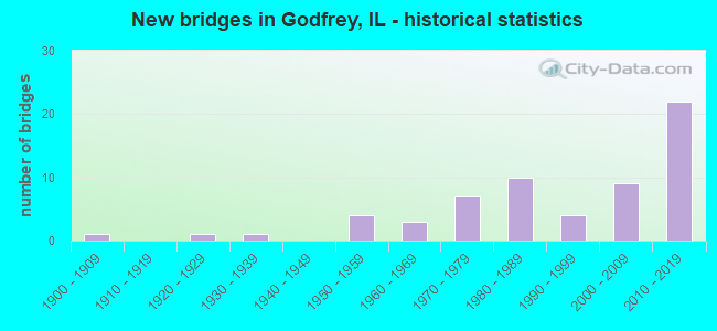
- New bridges - historical statistics
- 11900-1909
- 11920-1929
- 11930-1939
- 41950-1959
- 31960-1969
- 71970-1979
- 101980-1989
- 41990-1999
- 92000-2009
- 222010-2019

- Reconstructed bridges - Historical Statistics
- 11970-1979
- 41980-1989
- 01990-1999
- 42000-2009
- 12010-2019


- Bridge Condition - Deck
- 29.3%Very good
- 39.0%Good
- 22.0%Satisfactory
- 9.8%Fair

- Bridge Condition - Superstructure
- 2.3%Excellent
- 51.2%Very good
- 18.6%Good
- 16.3%Satisfactory
- 9.3%Fair
- 2.3%Serious

- Bridge Condition - Substructure
- 2.3%Excellent
- 46.5%Very good
- 23.3%Good
- 14.0%Satisfactory
- 11.6%Fair
- 2.3%Poor

- Bridge Condition - Channel
- 4.8%Excellent
- 21.4%Very good
- 16.7%Good
- 50.0%Satisfactory
- 4.8%Fair
- 2.4%Poor

- Bridge Condition - Culverts
- 60.0%Very good
- 30.0%Good
- 10.0%Fair
Find on map >> Show street view
Structure Number: 420023, Location: .7 MI N CLIFTON TERR (Lat: 38.939025, Lng: -90.288900), Route carried "on" structure: State highway 100, Year Built: 1997, Status: Open, Structure Length: 7.77m (25.49ft), Average Daily Traffic: 5,050 (year 2021), Truck Traffic: 5%, Average Future Daily Traffic: 2,853 (year 2032), Design Load: HS 20, Features Intersected: PIASA CREEK
Minimum Vertical Clearance: 30+ m (98+ ft), Kilometerpoint: 10.621, Lanes on structure: 2, Base Highway Network: Yes, Owner: State Highway Agency, Approaching Roadway Width: 11.6m (38.1ft), Material/Design: Prestressed concrete, Design/Construction: Stringer/Multi-beam, Number Of Spans In Main Unit: 3, Length of Maximum Span: 25.8m (84.6ft), Curb-To-Curb Width: 12.5m (41.0ft), Out-to-Out Width: 13.5m (44.3ft)
Condition: Deck: Satisfactory, Superstructure: Very good, Substructure: Good, Channel: Excellent, Operating Rating: 73.2 metric tons, Method Used To Determine Operating Rating: Load Factor (LF) rating reported by rating factor (RF) method using MS18 loading, Inventory Rating: 44.4 metric tons, Method Used To Determine Inventory Rating: Load Factor (LF) rating reported by rating factor (RF) method using MS18 loading, Structural Evaluation: Better than present minimum criteria, Deck Geometry: Better than present minimum criteria, Waterway Adequacy: Equal to present desirable criteria, Approach Roadway Alignment: Equal to present desirable criteria, Designated Inspection Frequency: Every 48 months, Inspection Date: Febuary 2021, Deck Structure Type: Concrete Cast-file-Place, Wearing Surface/Protective System: Deck Protection: Epoxy Coated Reinforcing
Find on map >> Show street view
Structure Number: 420024, Location: .7 MI N CLIFTON TERR (Lat: 38.939056, Lng: -90.288722), Route carried "on" structure: State highway 100, Year Built: 1997, Status: Open, Structure Length: 7.77m (25.49ft), Average Daily Traffic: 5,050 (year 2021), Truck Traffic: 5%, Average Future Daily Traffic: 2,853 (year 2032), Design Load: HS 20, Features Intersected: PIASA CREEK
Minimum Vertical Clearance: 30+ m (98+ ft), Kilometerpoint: 10.605, Lanes on structure: 2, Base Highway Network: Yes, Owner: State Highway Agency, Approaching Roadway Width: 11.6m (38.1ft), Material/Design: Prestressed concrete, Design/Construction: Stringer/Multi-beam, Number Of Spans In Main Unit: 3, Length of Maximum Span: 25.8m (84.6ft), Curb-To-Curb Width: 12.5m (41.0ft), Out-to-Out Width: 13.5m (44.3ft)
Condition: Deck: Good, Superstructure: Very good, Substructure: Good, Channel: Excellent, Operating Rating: 73.2 metric tons, Method Used To Determine Operating Rating: Load Factor (LF) rating reported by rating factor (RF) method using MS18 loading, Inventory Rating: 44.4 metric tons, Method Used To Determine Inventory Rating: Load Factor (LF) rating reported by rating factor (RF) method using MS18 loading, Structural Evaluation: Better than present minimum criteria, Deck Geometry: Better than present minimum criteria, Waterway Adequacy: Equal to present desirable criteria, Approach Roadway Alignment: Equal to present desirable criteria, Designated Inspection Frequency: Every 48 months, Inspection Date: Febuary 2021, Deck Structure Type: Concrete Cast-file-Place, Wearing Surface/Protective System: Deck Protection: Epoxy Coated Reinforcing
Find on map >> Show street view
Structure Number: 420026, Location: 7.6 MI S JERSEYVILLE (Lat: 39.019603, Lng: -90.247025), Route carried "on" structure: US 67, Year Built: 2012, Status: Open, Structure Length: 6.88m (22.57ft), Average Daily Traffic: 10,500 (year 2021), Truck Traffic: 11%, Average Future Daily Traffic: 9,632 (year 2032), Design Load: HS 20, Features Intersected: PIASA CREEK
Minimum Vertical Clearance: 30+ m (98+ ft), Kilometerpoint: 17.670, Lanes on structure: 2, Base Highway Network: Yes, Owner: State Highway Agency, Approaching Roadway Width: 12.2m (40.0ft), Material/Design: Prestressed concrete, Design/Construction: Stringer/Multi-beam, Number Of Spans In Main Unit: 3, Length of Maximum Span: 27.4m (89.9ft), Curb-To-Curb Width: 12.2m (40.0ft), Out-to-Out Width: 13.2m (43.3ft)
Condition: Deck: Good, Superstructure: Very good, Substructure: Very good, Channel: Very good, Operating Rating: 71.0 metric tons, Method Used To Determine Operating Rating: Load Factor (LF) rating reported by rating factor (RF) method using MS18 loading, Inventory Rating: 44.4 metric tons, Method Used To Determine Inventory Rating: Load Factor (LF) rating reported by rating factor (RF) method using MS18 loading, Structural Evaluation: Equal to present desirable criteria, Deck Geometry: Better than present minimum criteria, Waterway Adequacy: Superior to present desirable criteria, Approach Roadway Alignment: Equal to present desirable criteria, Designated Inspection Frequency: Every 48 months, Inspection Date: March 2021, Deck Structure Type: Concrete Cast-file-Place, Wearing Surface/Protective System: Deck Protection: Epoxy Coated Reinforcing
Find on map >> Show street view
Structure Number: 420027, Location: 7.6 MI S JERSEYVILLE (Lat: 39.019603, Lng: -90.247025), Route carried "on" structure: US 67, Year Built: 2012, Status: Open, Structure Length: 6.88m (22.57ft), Average Daily Traffic: 10,500 (year 2021), Truck Traffic: 11%, Average Future Daily Traffic: 9,632 (year 2032), Design Load: HS 20, Features Intersected: PIASA CREEK
Minimum Vertical Clearance: 30+ m (98+ ft), Kilometerpoint: 17.670, Lanes on structure: 2, Base Highway Network: Yes, Owner: State Highway Agency, Approaching Roadway Width: 12.2m (40.0ft), Material/Design: Prestressed concrete, Design/Construction: Stringer/Multi-beam, Number Of Spans In Main Unit: 3, Length of Maximum Span: 27.4m (89.9ft), Curb-To-Curb Width: 12.2m (40.0ft), Out-to-Out Width: 13.2m (43.3ft)
Condition: Deck: Good, Superstructure: Very good, Substructure: Very good, Channel: Very good, Operating Rating: 69.3 metric tons, Method Used To Determine Operating Rating: Load Factor (LF) rating reported by rating factor (RF) method using MS18 loading, Inventory Rating: 41.5 metric tons, Method Used To Determine Inventory Rating: Load Factor (LF) rating reported by rating factor (RF) method using MS18 loading, Structural Evaluation: Equal to present desirable criteria, Deck Geometry: Better than present minimum criteria, Waterway Adequacy: Superior to present desirable criteria, Approach Roadway Alignment: Equal to present desirable criteria, Designated Inspection Frequency: Every 48 months, Inspection Date: March 2021, Deck Structure Type: Concrete Cast-file-Place, Wearing Surface/Protective System: Deck Protection: Epoxy Coated Reinforcing
Find on map >> Show street view
Structure Number: 423011, Location: .75 E ILL 109 (Lat: 39.013978, Lng: -90.300861), Route carried "on" structure: County highway , Year Built: 1925, Year Reconstructed: 1991, Status: Open, Structure Length: 0.92m (3.02ft), Average Daily Traffic: 450 (year 2017), Truck Traffic: 7%, Average Future Daily Traffic: 838 (year 2032), Design Load: HS 20, Features Intersected: STREAM, Facility Carried by Structure: CH 5
Minimum Vertical Clearance: 30+ m (98+ ft), Kilometerpoint: 4.570, Lanes on structure: 2, Owner: County Highway Agency, Approaching Roadway Width: 6.1m (20.0ft), Material/Design: Prestressed concrete, Design/Construction: Box Beam or Girders - Multiple, Number Of Spans In Main Unit: 1, Length of Maximum Span: 8.0m (26.2ft), Curb-To-Curb Width: 7.3m (24.0ft), Out-to-Out Width: 7.3m (24.0ft)
Condition: Deck: Good, Superstructure: Good, Substructure: Good, Channel: Good, Operating Rating: 72.6 metric tons, Method Used To Determine Operating Rating: Load Factor (LF) rating reported by rating factor (RF) method using MS18 loading, Inventory Rating: 43.4 metric tons, Method Used To Determine Inventory Rating: Load Factor (LF) rating reported by rating factor (RF) method using MS18 loading, Structural Evaluation: Better than present minimum criteria, Deck Geometry: Meets minimum limits, Waterway Adequacy: Equal to present desirable criteria, Approach Roadway Alignment: Equal to present desirable criteria, Designated Inspection Frequency: Every 24 months, Inspection Date: March 2021, Deck Structure Type: Concrete Precast Panels, Wearing Surface/Protective System: Wearing Surface: Gravel
Find on map >> Show street view
Structure Number: 423085, Location: 1.2 M SW NEW DELHI (Lat: 39.015356, Lng: -90.269978), Route carried "on" structure: County highway , Year Built: 1972, Status: Open, Structure Length: 2.49m (8.17ft), Average Daily Traffic: 325 (year 2017), Truck Traffic: 13%, Average Future Daily Traffic: 366 (year 2032), Design Load: HS 15, Features Intersected: LITTLE PIASA CK, Facility Carried by Structure: TR 187
Minimum Vertical Clearance: 30+ m (98+ ft), Kilometerpoint: 2.897, Lanes on structure: 2, Owner: Town or Township Highway Agency, Approaching Roadway Width: 5.5m (18.0ft), Material/Design: Concrete, Design/Construction: Channel Beam, Number Of Spans In Main Unit: 3, Length of Maximum Span: 8.9m (29.2ft), Curb-To-Curb Width: 6.1m (20.0ft), Out-to-Out Width: 6.8m (22.3ft)
Condition: Deck: Satisfactory, Superstructure: Serious, Substructure: Satisfactory, Channel: Fair, Operating Rating: 46.0 metric tons, Method Used To Determine Operating Rating: Load Factor (LF) rating reported by rating factor (RF) method using MS18 loading, Inventory Rating: 17.5 metric tons, Method Used To Determine Inventory Rating: Load Factor (LF) rating reported by rating factor (RF) method using MS18 loading, Structural Evaluation: High priority of corrective action, Deck Geometry: Meets minimum limits, Waterway Adequacy: Equal to present minimum criteria, Approach Roadway Alignment: High priority of corrective action, Length Of Structure Improvement: 2.44m (8.01ft), Designated Inspection Frequency: Every 24 months, Inspection Date: May 2019, Bridge Improvement Cost: $86,000, Roadway Improvement Cost: $9,000, Total Project Cost: $95,000, Deck Structure Type: Concrete Precast Panels, Wearing Surface/Protective System: Wearing Surface: Gravel
Find on map >> Show street view
Structure Number: 423086, Location: 2.3 M E OF ILL 67 (Lat: 39.043256, Lng: -90.220789), Route carried "on" structure: County highway , Year Built: 1977, Status: Open, Structure Length: 4.40m (14.44ft), Average Daily Traffic: 1,200 (year 2017), Truck Traffic: 4%, Average Future Daily Traffic: 1,413 (year 2032), Design Load: HS 15, Features Intersected: PIASA CREEK, Facility Carried by Structure: FAS 748
Minimum Vertical Clearance: 30+ m (98+ ft), Kilometerpoint: 3.734, Lanes on structure: 2, Owner: County Highway Agency, Approaching Roadway Width: 9.1m (29.9ft), Material/Design: Prestressed concrete, Design/Construction: Box Beam or Girders - Multiple, Number Of Spans In Main Unit: 3, Length of Maximum Span: 14.1m (46.3ft), Curb-To-Curb Width: 8.5m (27.9ft), Out-to-Out Width: 8.5m (27.9ft)
Condition: Deck: Satisfactory, Superstructure: Satisfactory, Substructure: Satisfactory, Channel: Satisfactory, Operating Rating: 49.9 metric tons, Method Used To Determine Operating Rating: Load Factor (LF) rating reported by rating factor (RF) method using MS18 loading, Inventory Rating: 30.5 metric tons, Method Used To Determine Inventory Rating: Load Factor (LF) rating reported by rating factor (RF) method using MS18 loading, Structural Evaluation: Equal to present minimum criteria, Deck Geometry: Somewhat better than minimum adequacy, Waterway Adequacy: Better than present minimum criteria, Approach Roadway Alignment: Better than present minimum criteria, Designated Inspection Frequency: Every 24 months, Inspection Date: May 2019, Deck Structure Type: Concrete Precast Panels, Wearing Surface/Protective System: Wearing Surface: Bituminous, Membrane: Built-up
Find on map >> Show street view
Structure Number: 423088, Location: 4.3 M W BRIGHTON (Lat: 39.043581, Lng: -90.229922), Route carried "on" structure: County highway , Year Built: 1977, Status: Open, Structure Length: 4.99m (16.37ft), Average Daily Traffic: 1,200 (year 2017), Truck Traffic: 4%, Average Future Daily Traffic: 1,413 (year 2032), Design Load: HS 15, Features Intersected: PIASA CREEK, Facility Carried by Structure: FAS 748
Minimum Vertical Clearance: 30+ m (98+ ft), Kilometerpoint: 2.800, Lanes on structure: 2, Owner: County Highway Agency, Approaching Roadway Width: 9.1m (29.9ft), Skew: 1 degrees, Material/Design: Prestressed concrete, Design/Construction: Box Beam or Girders - Multiple, Number Of Spans In Main Unit: 3, Length of Maximum Span: 16.1m (52.8ft), Curb-To-Curb Width: 8.5m (27.9ft), Out-to-Out Width: 8.5m (27.9ft)
Condition: Deck: Satisfactory, Superstructure: Satisfactory, Substructure: Satisfactory, Channel: Satisfactory, Operating Rating: 45.0 metric tons, Method Used To Determine Operating Rating: Load Factor (LF) rating reported by rating factor (RF) method using MS18 loading, Inventory Rating: 27.5 metric tons, Method Used To Determine Inventory Rating: Load Factor (LF) rating reported by rating factor (RF) method using MS18 loading, Structural Evaluation: Equal to present minimum criteria, Deck Geometry: Somewhat better than minimum adequacy, Waterway Adequacy: Better than present minimum criteria, Approach Roadway Alignment: Better than present minimum criteria, Designated Inspection Frequency: Every 24 months, Inspection Date: May 2019, Deck Structure Type: Concrete Precast Panels, Wearing Surface/Protective System: Wearing Surface: Bituminous, Membrane: Built-up
Find on map >> Show street view
Structure Number: 423099, Location: 3.0 MI E ELSAH (Lat: 38.952661, Lng: -90.304736), Route carried "on" structure: County highway , Year Built: 1980, Status: Open, Structure Length: 2.29m (7.51ft), Average Daily Traffic: 300 (year 2017), Truck Traffic: 13%, Average Future Daily Traffic: 419 (year 2032), Design Load: HS 20, Features Intersected: MILL CREEK, Facility Carried by Structure: TR 132
Minimum Vertical Clearance: 30+ m (98+ ft), Kilometerpoint: 0.354, Lanes on structure: 2, Owner: Town or Township Highway Agency, Approaching Roadway Width: 5.5m (18.0ft), Material/Design: Prestressed concrete, Design/Construction: Box Beam or Girders - Multiple, Number Of Spans In Main Unit: 3, Length of Maximum Span: 7.3m (24.0ft), Curb-To-Curb Width: 8.8m (28.9ft), Out-to-Out Width: 8.9m (29.2ft)
Condition: Deck: Satisfactory, Superstructure: Satisfactory, Substructure: Good, Channel: Satisfactory, Operating Rating: 44.4 metric tons, Method Used To Determine Operating Rating: Assigned rating based on Load Factor Design (LFD) reported by rating factor (RF) using MS18 loading, Inventory Rating: 32.4 metric tons, Method Used To Determine Inventory Rating: Assigned rating based on Load Factor Design (LFD) reported by rating factor (RF) using MS18 loading, Structural Evaluation: Equal to present minimum criteria, Deck Geometry: Equal to present minimum criteria, Waterway Adequacy: Better than present minimum criteria, Approach Roadway Alignment: Better than present minimum criteria, Designated Inspection Frequency: Every 24 months, Inspection Date: Febuary 2021, Deck Structure Type: Concrete Precast Panels, Wearing Surface/Protective System: Wearing Surface: Gravel
Find on map >> Show street view
Structure Number: 423103, Location: 3M SW BRIGHTON (Lat: 39.004347, Lng: -90.192919), Route carried "on" structure: County highway , Year Built: 1986, Status: Open, Structure Length: 0.94m (3.08ft), Average Daily Traffic: 75 (year 2017), Truck Traffic: 9%, Average Future Daily Traffic: 52 (year 2032), Design Load: HS 20, Features Intersected: BRANCH OFPIASA CREEK, Facility Carried by Structure: TR 185
Minimum Vertical Clearance: 30+ m (98+ ft), Kilometerpoint: 4.281, Lanes on structure: 2, Owner: Town or Township Highway Agency, Approaching Roadway Width: 4.3m (14.1ft), Skew: 3 degrees, Material/Design: Concrete continuous, Design/Construction: Culvert, Number Of Spans In Main Unit: 2, Length of Maximum Span: 4.3m (14.1ft), Curb-To-Curb Width: 7.4m (24.3ft), Out-to-Out Width: 7.4m (24.3ft)
Condition: Channel: Satisfactory, Culverts: Good, Operating Rating: 44.4 metric tons, Method Used To Determine Operating Rating: Assigned rating based on Load Factor Design (LFD) reported by rating factor (RF) using MS18 loading, Inventory Rating: 32.4 metric tons, Method Used To Determine Inventory Rating: Assigned rating based on Load Factor Design (LFD) reported by rating factor (RF) using MS18 loading, Structural Evaluation: Better than present minimum criteria, Deck Geometry: Equal to present minimum criteria, Waterway Adequacy: Better than present minimum criteria, Approach Roadway Alignment: Better than present minimum criteria, Designated Inspection Frequency: Every 48 months, Inspection Date: Febuary 2019
Find on map >> Show street view
Structure Number: 423118, Location: .5 MI. W. NEW DELHI (Lat: 39.030428, Lng: -90.266772), Route carried "on" structure: County highway , Year Built: 1975, Status: Open, Structure Length: 0.79m (2.59ft), Average Daily Traffic: 150 (year 2017), Truck Traffic: 11%, Average Future Daily Traffic: 314 (year 2032), Features Intersected: BRANCH LITTLE PIASA, Facility Carried by Structure: TR 150C
Minimum Vertical Clearance: 30+ m (98+ ft), Kilometerpoint: 0.402, Lanes on structure: 1, Owner: Town or Township Highway Agency, Approaching Roadway Width: 4.9m (16.1ft), Skew: 2 degrees, Material/Design: Steel, Design/Construction: Stringer/Multi-beam, Number Of Spans In Main Unit: 1, Length of Maximum Span: 7.6m (24.9ft), Curb-To-Curb Width: 4.9m (16.1ft), Out-to-Out Width: 5.0m (16.4ft)
Condition: Deck: Satisfactory, Superstructure: Satisfactory, Substructure: Satisfactory, Channel: Good, Operating Rating: 34.7 metric tons, Method Used To Determine Operating Rating: Load Factor (LF) rating reported by rating factor (RF) method using MS18 loading, Inventory Rating: 20.7 metric tons, Method Used To Determine Inventory Rating: Load Factor (LF) rating reported by rating factor (RF) method using MS18 loading, Structural Evaluation: Equal to present minimum criteria, Deck Geometry: High priority of replacement, Waterway Adequacy: Better than present minimum criteria, Approach Roadway Alignment: Somewhat better than minimum adequacy, Length Of Structure Improvement: 0.79m (2.59ft), Designated Inspection Frequency: Every 24 months, Inspection Date: May 2019, Bridge Improvement Cost: $20,000, Roadway Improvement Cost: $2,000, Total Project Cost: $22,000, Deck Structure Type: Wood or Timber, Wearing Surface/Protective System: Wearing Surface: Wood or Timber
Find on map >> Show street view
Structure Number: 423129, Location: 2MI SO. OF BRIGHTON (Lat: 39.009617, Lng: -90.146044), Route carried "on" structure: County highway , Year Built: 1999, Status: Open, Structure Length: 1.71m (5.61ft), Average Daily Traffic: 50 (year 2016), Truck Traffic: 4%, Average Future Daily Traffic: 604 (year 2032), Design Load: HS 20, Features Intersected: CREEK, Facility Carried by Structure: COUNTY LINE RD
Minimum Vertical Clearance: 30+ m (98+ ft), Kilometerpoint: 2.527, Lanes on structure: 2, Owner: Town or Township Highway Agency, Approaching Roadway Width: 4.6m (15.1ft), Material/Design: Prestressed concrete, Design/Construction: Box Beam or Girders - Multiple, Number Of Spans In Main Unit: 1, Length of Maximum Span: 16.3m (53.5ft), Curb-To-Curb Width: 7.3m (24.0ft), Out-to-Out Width: 7.4m (24.3ft)
Condition: Deck: Good, Superstructure: Good, Substructure: Very good, Channel: Very good, Operating Rating: 44.1 metric tons, Method Used To Determine Operating Rating: Assigned rating based on Load Factor Design (LFD) reported by rating factor (RF) using MS18 loading, Inventory Rating: 32.4 metric tons, Method Used To Determine Inventory Rating: Assigned rating based on Load Factor Design (LFD) reported by rating factor (RF) using MS18 loading, Structural Evaluation: Better than present minimum criteria, Deck Geometry: Equal to present minimum criteria, Waterway Adequacy: Equal to present desirable criteria, Approach Roadway Alignment: Equal to present desirable criteria, Designated Inspection Frequency: Every 48 months, Inspection Date: March 2019, Deck Structure Type: Concrete Precast Panels, Wearing Surface/Protective System: Wearing Surface: Gravel
Find on map >> Show street view
Structure Number: 423148, Location: 1 MI W OF DELHI (Lat: 39.039378, Lng: -90.266036), Route carried "on" structure: County highway , Year Built: 2008, Status: Open, Structure Length: 0.71m (2.33ft), Average Daily Traffic: 900 (year 2017), Truck Traffic: 7%, Average Future Daily Traffic: 995 (year 2032), Design Load: HS 20, Features Intersected: TRIB OF LITTLE PIASA, Facility Carried by Structure: MCCLUSKY RD FAS 74
Minimum Vertical Clearance: 30+ m (98+ ft), Kilometerpoint: 12.247, Lanes on structure: 2, Owner: County Highway Agency, Approaching Roadway Width: 6.7m (22.0ft), Skew: 1 degrees, Material/Design: Concrete continuous, Design/Construction: Culvert, Number Of Spans In Main Unit: 2, Length of Maximum Span: 3.4m (11.2ft)
Condition: Channel: Good, Culverts: Good, Operating Rating: 44.1 metric tons, Method Used To Determine Operating Rating: Assigned rating based on Load Factor Design (LFD) reported by rating factor (RF) using MS18 loading, Inventory Rating: 32.4 metric tons, Method Used To Determine Inventory Rating: Assigned rating based on Load Factor Design (LFD) reported by rating factor (RF) using MS18 loading, Structural Evaluation: Better than present minimum criteria, Waterway Adequacy: Equal to present desirable criteria, Approach Roadway Alignment: Better than present minimum criteria, Designated Inspection Frequency: Every 48 months, Inspection Date: March 2019
Find on map >> Show street view
Structure Number: 423149, Location: 3 M E DOW (Lat: 39.000428, Lng: -90.282294), Route carried "on" structure: County highway , Year Built: 2011, Status: Open, Structure Length: 0.95m (3.12ft), Average Daily Traffic: 75 (year 2017), Truck Traffic: 19%, Average Future Daily Traffic: 52 (year 2032), Design Load: HS 20, Features Intersected: TRIB TO PIASA CREEK, Facility Carried by Structure: TR 136
Minimum Vertical Clearance: 30+ m (98+ ft), Kilometerpoint: 1.690, Lanes on structure: 2, Owner: Town or Township Highway Agency, Approaching Roadway Width: 5.5m (18.0ft), Skew: 3 degrees, Material/Design: Aluminum, Iron, Design/Construction: Culvert, Number Of Spans In Main Unit: 1, Length of Maximum Span: 8.9m (29.2ft)
Condition: Channel: Satisfactory, Culverts: Very good, Operating Rating: 44.1 metric tons, Method Used To Determine Operating Rating: Assigned rating based on Load Factor Design (LFD) reported by rating factor (RF) using MS18 loading, Inventory Rating: 32.4 metric tons, Method Used To Determine Inventory Rating: Assigned rating based on Load Factor Design (LFD) reported by rating factor (RF) using MS18 loading, Structural Evaluation: Equal to present desirable criteria, Waterway Adequacy: Equal to present desirable criteria, Approach Roadway Alignment: Equal to present minimum criteria, Designated Inspection Frequency: Every 24 months, Inspection Date: May 2019
Find on map >> Show street view
Structure Number: 423151, Location: 3 mi SW Brighton (Lat: 39.017567, Lng: -90.199836), Route carried "on" structure: County highway , Year Built: 2013, Status: Open, Structure Length: 2.16m (7.09ft), Average Daily Traffic: 350 (year 2017), Truck Traffic: 12%, Average Future Daily Traffic: 419 (year 2032), Design Load: HS 25 or greater, Features Intersected: Little Piasa Creek, Facility Carried by Structure: TR 179
Minimum Vertical Clearance: 30+ m (98+ ft), Kilometerpoint: 0.998, Lanes on structure: 2, Owner: Town or Township Highway Agency, Approaching Roadway Width: 6.7m (22.0ft), Skew: 2 degrees, Material/Design: Prestressed concrete, Design/Construction: Box Beam or Girders - Multiple, Number Of Spans In Main Unit: 1, Length of Maximum Span: 20.8m (68.2ft), Curb-To-Curb Width: 9.3m (30.5ft), Out-to-Out Width: 9.3m (30.5ft)
Condition: Deck: Good, Superstructure: Good, Substructure: Very good, Channel: Very good, Operating Rating: 42.1 metric tons, Method Used To Determine Operating Rating: Assigned ratings based on Load and Resistance Factor Design (LRFD) reported by rating factor (RF) using HL93 loadings, Inventory Rating: 32.4 metric tons, Method Used To Determine Inventory Rating: Assigned ratings based on Load and Resistance Factor Design (LRFD) reported by rating factor (RF) using HL93 loadings, Structural Evaluation: Better than present minimum criteria, Deck Geometry: Equal to present minimum criteria, Waterway Adequacy: Equal to present desirable criteria, Approach Roadway Alignment: Equal to present minimum criteria, Designated Inspection Frequency: Every 48 months, Inspection Date: March 2019, Deck Structure Type: Concrete Precast Panels, Wearing Surface/Protective System: Wearing Surface: Gravel
Find on map >> Show street view
Structure Number: 424002, Location: 2.5 Mi E of Elsah (Lat: 38.956692, Lng: -90.304753), Route carried "on" structure: County highway , Year Built: 1983, Status: Open, Structure Length: 2.62m (8.60ft), Average Daily Traffic: 450 (year 2017), Truck Traffic: 13%, Average Future Daily Traffic: 524 (year 2032), Design Load: HS 20, Features Intersected: TRIB TO MILL CK, Facility Carried by Structure: CH 23
Minimum Vertical Clearance: 30+ m (98+ ft), Kilometerpoint: 5.134, Lanes on structure: 2, Owner: County Highway Agency, Approaching Roadway Width: 5.8m (19.0ft), Skew: 3 degrees, Material/Design: Concrete, Design/Construction: Channel Beam, Number Of Spans In Main Unit: 3, Length of Maximum Span: 8.5m (27.9ft), Curb-To-Curb Width: 9.2m (30.2ft), Out-to-Out Width: 9.2m (30.2ft)
Condition: Deck: Very good, Superstructure: Satisfactory, Substructure: Good, Channel: Satisfactory, Operating Rating: 44.4 metric tons, Method Used To Determine Operating Rating: Assigned rating based on Load Factor Design (LFD) reported by rating factor (RF) using MS18 loading, Inventory Rating: 32.4 metric tons, Method Used To Determine Inventory Rating: Assigned rating based on Load Factor Design (LFD) reported by rating factor (RF) using MS18 loading, Structural Evaluation: Equal to present minimum criteria, Deck Geometry: Equal to present minimum criteria, Waterway Adequacy: Better than present minimum criteria, Approach Roadway Alignment: Better than present minimum criteria, Designated Inspection Frequency: Every 24 months, Inspection Date: Febuary 2021, Deck Structure Type: Concrete Precast Panels, Wearing Surface/Protective System: Wearing Surface: Gravel
Find on map >> Show street view
Structure Number: 424003, Location: 4M SW BRIGHTON (Lat: 39.006583, Lng: -90.206069), Route carried "on" structure: County highway , Year Built: 1982, Status: Open, Structure Length: 2.99m (9.81ft), Average Daily Traffic: 75 (year 2017), Truck Traffic: 9%, Average Future Daily Traffic: 52 (year 2032), Design Load: HS 20, Features Intersected: LITTLE PIASA CREEK, Facility Carried by Structure: TR 185
Minimum Vertical Clearance: 30+ m (98+ ft), Kilometerpoint: 2.977, Lanes on structure: 2, Owner: Town or Township Highway Agency, Approaching Roadway Width: 4.9m (16.1ft), Skew: 4 degrees, Material/Design: Prestressed concrete, Design/Construction: Box Beam or Girders - Multiple, Number Of Spans In Main Unit: 3, Length of Maximum Span: 9.8m (32.2ft), Curb-To-Curb Width: 7.6m (24.9ft), Out-to-Out Width: 7.7m (25.3ft)
Condition: Deck: Good, Superstructure: Good, Substructure: Satisfactory, Channel: Satisfactory, Operating Rating: 44.4 metric tons, Method Used To Determine Operating Rating: Assigned rating based on Load Factor Design (LFD) reported by rating factor (RF) using MS18 loading, Inventory Rating: 32.4 metric tons, Method Used To Determine Inventory Rating: Assigned rating based on Load Factor Design (LFD) reported by rating factor (RF) using MS18 loading, Structural Evaluation: Equal to present minimum criteria, Deck Geometry: Equal to present minimum criteria, Waterway Adequacy: Better than present minimum criteria, Approach Roadway Alignment: Equal to present desirable criteria, Designated Inspection Frequency: Every 24 months, Inspection Date: May 2019, Deck Structure Type: Concrete Precast Panels, Wearing Surface/Protective System: Wearing Surface: Gravel
Find on map >> Show street view
Structure Number: 42401, Location: 2.2 MI W ILL 67 (Lat: 39.039389, Lng: -90.297594), Route carried "on" structure: County highway , Year Built: 1901, Year Reconstructed: 1982, Status: Open, Structure Length: 0.98m (3.22ft), Average Daily Traffic: 500 (year 2017), Truck Traffic: 19%, Average Future Daily Traffic: 419 (year 2032), Design Load: HS 20, Features Intersected: LITTLE PIASA CREEK, Facility Carried by Structure: FAS 748
Minimum Vertical Clearance: 30+ m (98+ ft), Kilometerpoint: 9.511, Lanes on structure: 2, Owner: County Highway Agency, Approaching Roadway Width: 6.1m (20.0ft), Skew: 2 degrees, Material/Design: Prestressed concrete, Design/Construction: Box Beam or Girders - Multiple, Number Of Spans In Main Unit: 1, Length of Maximum Span: 9.1m (29.9ft), Curb-To-Curb Width: 9.2m (30.2ft), Out-to-Out Width: 9.2m (30.2ft)
Condition: Deck: Good, Superstructure: Good, Substructure: Good, Channel: Satisfactory, Operating Rating: 62.5 metric tons, Method Used To Determine Operating Rating: Load Factor (LF) rating reported by rating factor (RF) method using MS18 loading, Inventory Rating: 37.6 metric tons, Method Used To Determine Inventory Rating: Load Factor (LF) rating reported by rating factor (RF) method using MS18 loading, Structural Evaluation: Better than present minimum criteria, Deck Geometry: Equal to present minimum criteria, Waterway Adequacy: Better than present minimum criteria, Approach Roadway Alignment: Equal to present desirable criteria, Designated Inspection Frequency: Every 24 months, Inspection Date: May 2019, Deck Structure Type: Concrete Precast Panels, Wearing Surface/Protective System: Wearing Surface: Gravel
Find on map >> Show street view
Structure Number: 600061, Location: 9.3 M S JERSEYVILLE (Lat: 38.999333, Lng: -90.231858), Route carried "on" structure: US 67, Year Built: 1939, Year Reconstructed: 2012, Status: Open, Structure Length: 1.77m (5.81ft), Average Daily Traffic: 10,500 (year 2021), Truck Traffic: 11%, Average Future Daily Traffic: 4,876 (year 2032), Design Load: H 20, Features Intersected: LITTLE PIASA CREEK
Minimum Vertical Clearance: 30+ m (98+ ft), Kilometerpoint: 17.236, Lanes on structure: 2, Base Highway Network: Yes, Owner: State Highway Agency, Approaching Roadway Width: 9.1m (29.9ft), Material/Design: Concrete, Design/Construction: Arch - Deck, Number Of Spans In Main Unit: 1, Length of Maximum Span: 16.5m (54.1ft), Curb-To-Curb Width: 11.0m (36.1ft), Out-to-Out Width: 12.5m (41.0ft)
Condition: Superstructure: Good, Substructure: Good, Channel: Satisfactory, Operating Rating: 57.3 metric tons, Method Used To Determine Operating Rating: Load Factor (LF) rating reported by rating factor (RF) method using MS18 loading, Inventory Rating: 34.3 metric tons, Method Used To Determine Inventory Rating: Load Factor (LF) rating reported by rating factor (RF) method using MS18 loading, Structural Evaluation: Better than present minimum criteria, Deck Geometry: Meets minimum limits, Waterway Adequacy: Equal to present desirable criteria, Approach Roadway Alignment: Equal to present desirable criteria, Designated Inspection Frequency: Every 48 months, Inspection Date: March 2021
Find on map >> Show street view
Structure Number: 600118, Location: 1 M E JCT 111 (Lat: 38.922519, Lng: -90.180803), Route carried "on" structure: State highway 3, Year Built: 1958, Year Reconstructed: 1994, Status: Open, Structure Length: 14.51m (47.60ft), Average Daily Traffic: 14,100 (year 2021), Truck Traffic: 6%, Average Future Daily Traffic: 21,094 (year 2032), Design Load: HS 20, Features Intersected: US 67, Facility Carried by Structure: IL 111 - HOMER ADA
Minimum Vertical Clearance: 30+ m (98+ ft), Kilometerpoint: 276.059, Lanes on structure: 4, Lanes under structure: 2, Base Highway Network: Yes, Owner: State Highway Agency, Approaching Roadway Width: 21.9m (71.9ft), Skew: 26 degrees, Material/Design: Steel continuous, Design/Construction: Stringer/Multi-beam, Number Of Spans In Main Unit: 4, Length of Maximum Span: 39.9m (130.9ft), Curb-To-Curb Width: 28.8m (94.5ft), Out-to-Out Width: 35.2m (115.5ft)
Condition: Deck: Good, Superstructure: Satisfactory, Substructure: Good, Operating Rating: 69.7 metric tons, Method Used To Determine Operating Rating: Load Factor (LF) rating reported by rating factor (RF) method using MS18 loading, Inventory Rating: 41.8 metric tons, Method Used To Determine Inventory Rating: Load Factor (LF) rating reported by rating factor (RF) method using MS18 loading, Structural Evaluation: Equal to present minimum criteria, Deck Geometry: Superior to present desirable criteria, Underclear: Meets minimum limits, Approach Roadway Alignment: Equal to present desirable criteria, Designated Inspection Frequency: Every 24 months, Inspection Date: April 2021, Deck Structure Type: Concrete Cast-file-Place, Wearing Surface/Protective System: Deck Protection: Epoxy Coated Reinforcing
Find on map >> Show street view
Structure Number: 60025, Location: 1.4MI S JERSEY CO LN (Lat: 38.987172, Lng: -90.211842), Route carried "on" structure: US 67, Year Built: 1988, Status: Open, Structure Length: 1.58m (5.18ft), Average Daily Traffic: 11,600 (year 2021), Truck Traffic: 9%, Average Future Daily Traffic: 4,823 (year 2032), Design Load: HS 20, Features Intersected: TRIB S BR PIASA CRK
Minimum Vertical Clearance: 30+ m (98+ ft), Kilometerpoint: 15.079, Lanes on structure: 2, Base Highway Network: Yes, Owner: State Highway Agency, Approaching Roadway Width: 9.1m (29.9ft), Skew: 3 degrees, Material/Design: Steel, Design/Construction: Stringer/Multi-beam, Number Of Spans In Main Unit: 1, Length of Maximum Span: 15.8m (51.8ft), Curb-To-Curb Width: 12.2m (40.0ft), Out-to-Out Width: 13.2m (43.3ft)
Condition: Deck: Good, Superstructure: Very good, Substructure: Very good, Channel: Good, Operating Rating: 75.8 metric tons, Method Used To Determine Operating Rating: Load Factor (LF) rating reported by rating factor (RF) method using MS18 loading, Inventory Rating: 45.4 metric tons, Method Used To Determine Inventory Rating: Load Factor (LF) rating reported by rating factor (RF) method using MS18 loading, Structural Evaluation: Equal to present desirable criteria, Deck Geometry: Better than present minimum criteria, Waterway Adequacy: Equal to present desirable criteria, Approach Roadway Alignment: Equal to present desirable criteria, Designated Inspection Frequency: Every 48 months, Inspection Date: March 2021, Deck Structure Type: Concrete Cast-file-Place, Wearing Surface/Protective System: Wearing Surface: Bituminous, Membrane: Built-up, Deck Protection: Epoxy Coated Reinforcing
Find on map >> Show street view
Structure Number: 600251, Location: 1.3MI S JERSEY CO LN (Lat: 38.988286, Lng: -90.212908), Route carried "on" structure: US 67, Year Built: 1988, Status: Open, Structure Length: 1.71m (5.61ft), Average Daily Traffic: 11,600 (year 2021), Truck Traffic: 9%, Average Future Daily Traffic: 4,823 (year 2032), Design Load: HS 20, Features Intersected: SO BR PIASA CREEK
Minimum Vertical Clearance: 30+ m (98+ ft), Kilometerpoint: 15.224, Lanes on structure: 2, Base Highway Network: Yes, Owner: State Highway Agency, Approaching Roadway Width: 9.1m (29.9ft), Material/Design: Steel, Design/Construction: Stringer/Multi-beam, Number Of Spans In Main Unit: 1, Length of Maximum Span: 17.0m (55.8ft), Curb-To-Curb Width: 12.2m (40.0ft), Out-to-Out Width: 13.2m (43.3ft)
Condition: Deck: Good, Superstructure: Very good, Substructure: Very good, Channel: Satisfactory, Operating Rating: 87.5 metric tons, Method Used To Determine Operating Rating: Load Factor (LF) rating reported by rating factor (RF) method using MS18 loading, Inventory Rating: 52.5 metric tons, Method Used To Determine Inventory Rating: Load Factor (LF) rating reported by rating factor (RF) method using MS18 loading, Structural Evaluation: Equal to present desirable criteria, Deck Geometry: Better than present minimum criteria, Waterway Adequacy: Equal to present desirable criteria, Approach Roadway Alignment: Equal to present desirable criteria, Designated Inspection Frequency: Every 48 months, Inspection Date: March 2021, Deck Structure Type: Concrete Cast-file-Place, Wearing Surface/Protective System: Wearing Surface: Bituminous, Membrane: Built-up, Deck Protection: Epoxy Coated Reinforcing
Find on map >> Show street view
Structure Number: 600304, Location: 1.5MI S SEILER RD (Lat: 38.948069, Lng: -90.141644), Route carried "on" structure: State highway 255, Year Built: 2006, Status: Open, Structure Length: 3.34m (10.96ft), Average Daily Traffic: 15,400 (year 2021), Truck Traffic: 10%, Average Future Daily Traffic: 4,744 (year 2032), Design Load: HS 20, Features Intersected: FAS 1765 SEMINARY RD
Minimum Vertical Clearance: 30+ m (98+ ft), Kilometerpoint: 26.393, Lanes on structure: 2, Lanes under structure: 2, Base Highway Network: Yes, Owner: State Highway Agency, Approaching Roadway Width: 12.2m (40.0ft), Material/Design: Steel, Design/Construction: Stringer/Multi-beam, Number Of Spans In Main Unit: 1, Number Of Approach Spans: 2, Length of Maximum Span: 33.4m (109.6ft), Curb-To-Curb Width: 12.6m (41.3ft), Out-to-Out Width: 13.6m (44.6ft)
Condition: Deck: Good, Superstructure: Very good, Substructure: Very good, Operating Rating: 93.3 metric tons, Method Used To Determine Operating Rating: Load Factor (LF) rating reported by rating factor (RF) method using MS18 loading, Inventory Rating: 36.6 metric tons, Method Used To Determine Inventory Rating: Load Factor (LF) rating reported by rating factor (RF) method using MS18 loading, Structural Evaluation: Equal to present desirable criteria, Deck Geometry: Better than present minimum criteria, Underclear: Superior to present desirable criteria, Approach Roadway Alignment: Equal to present desirable criteria, Designated Inspection Frequency: Every 24 months, Inspection Date: November 2020, Deck Structure Type: Concrete Cast-file-Place, Wearing Surface/Protective System: Deck Protection: Epoxy Coated Reinforcing
Find on map >> Show street view
Structure Number: 600305, Location: 1.5MI S SEILER RD (Lat: 38.948069, Lng: -90.141817), Route carried "on" structure: State highway 255, Year Built: 2006, Status: Open, Structure Length: 3.34m (10.96ft), Average Daily Traffic: 14,000 (year 2021), Truck Traffic: 10%, Average Future Daily Traffic: 4,240 (year 2032), Design Load: HS 20, Features Intersected: FAS 1765 SEMINARY RD
Minimum Vertical Clearance: 30+ m (98+ ft), Kilometerpoint: 26.409, Lanes on structure: 2, Lanes under structure: 2, Base Highway Network: Yes, Owner: State Highway Agency, Approaching Roadway Width: 12.2m (40.0ft), Material/Design: Steel, Design/Construction: Stringer/Multi-beam, Number Of Spans In Main Unit: 1, Number Of Approach Spans: 2, Length of Maximum Span: 33.0m (108.3ft), Curb-To-Curb Width: 12.6m (41.3ft), Out-to-Out Width: 13.6m (44.6ft)
Condition: Deck: Very good, Superstructure: Very good, Substructure: Very good, Operating Rating: 93.3 metric tons, Method Used To Determine Operating Rating: Load Factor (LF) rating reported by rating factor (RF) method using MS18 loading, Inventory Rating: 36.6 metric tons, Method Used To Determine Inventory Rating: Load Factor (LF) rating reported by rating factor (RF) method using MS18 loading, Structural Evaluation: Equal to present desirable criteria, Deck Geometry: Better than present minimum criteria, Underclear: Superior to present desirable criteria, Approach Roadway Alignment: Equal to present desirable criteria, Designated Inspection Frequency: Every 24 months, Inspection Date: November 2020, Deck Structure Type: Concrete Cast-file-Place, Wearing Surface/Protective System: Deck Protection: Epoxy Coated Reinforcing
Find on map >> Show street view
Structure Number: 600306, Location: 1.1MI NW SEMINARY RD (Lat: 38.951700, Lng: -90.160742), Route carried "on" structure: City street , Year Built: 2010, Status: Open, Structure Length: 5.69m (18.67ft), Average Daily Traffic: 425 (year 2016), Truck Traffic: 7%, Average Future Daily Traffic: 530 (year 2032), Design Load: HS 20, Features Intersected: IL 255 FAP 310, Facility Carried by Structure: WENZEL RD MSS 6925
Minimum Vertical Clearance: 30+ m (98+ ft), Kilometerpoint: 1.851, Lanes on structure: 2, Lanes under structure: 4, Owner: State Highway Agency, Approaching Roadway Width: 10.2m (33.5ft), Skew: 2 degrees, Material/Design: Steel continuous, Design/Construction: Stringer/Multi-beam, Number Of Spans In Main Unit: 2, Number Of Approach Spans: 2, Length of Maximum Span: 29.0m (95.1ft), Curb-To-Curb Width: 10.2m (33.5ft), Out-to-Out Width: 11.2m (36.7ft)
Condition: Deck: Very good, Superstructure: Very good, Substructure: Very good, Operating Rating: 78.1 metric tons, Method Used To Determine Operating Rating: Load Factor (LF) rating reported by rating factor (RF) method using MS18 loading, Inventory Rating: 46.7 metric tons, Method Used To Determine Inventory Rating: Load Factor (LF) rating reported by rating factor (RF) method using MS18 loading, Structural Evaluation: Equal to present desirable criteria, Deck Geometry: Equal to present minimum criteria, Underclear: Meets minimum limits, Approach Roadway Alignment: Equal to present desirable criteria, Designated Inspection Frequency: Every 48 months, Inspection Date: November 2020, Deck Structure Type: Concrete Cast-file-Place, Wearing Surface/Protective System: Deck Protection: Epoxy Coated Reinforcing
Find on map >> Show street view
Structure Number: 600308, Location: 2.8MI W OF SEMINARY (Lat: 38.963950, Lng: -90.180869), Route carried "on" structure: State highway 255, Year Built: 2012, Status: Open, Structure Length: 4.55m (14.93ft), Average Daily Traffic: 6,400 (year 2021), Truck Traffic: 13%, Average Future Daily Traffic: 4,744 (year 2032), Design Load: HS 20, Features Intersected: HUMBERT RD (CH 4)
Minimum Vertical Clearance: 30+ m (98+ ft), Kilometerpoint: 30.947, Lanes on structure: 2, Lanes under structure: 4, Base Highway Network: Yes, Owner: State Highway Agency, Approaching Roadway Width: 12.8m (42.0ft), Material/Design: Steel, Design/Construction: Stringer/Multi-beam, Number Of Spans In Main Unit: 1, Number Of Approach Spans: 2, Length of Maximum Span: 45.0m (147.6ft), Curb-To-Curb Width: 12.8m (42.0ft), Out-to-Out Width: 13.8m (45.3ft)
Condition: Deck: Good, Superstructure: Very good, Substructure: Very good, Operating Rating: 68.7 metric tons, Method Used To Determine Operating Rating: Load Factor (LF) rating reported by rating factor (RF) method using MS18 loading, Inventory Rating: 41.1 metric tons, Method Used To Determine Inventory Rating: Load Factor (LF) rating reported by rating factor (RF) method using MS18 loading, Structural Evaluation: Equal to present desirable criteria, Deck Geometry: Equal to present desirable criteria, Approach Roadway Alignment: Equal to present desirable criteria, Designated Inspection Frequency: Every 24 months, Inspection Date: November 2020, Deck Structure Type: Concrete Cast-file-Place, Wearing Surface/Protective System: Deck Protection: Epoxy Coated Reinforcing
Find on map >> Show street view
Structure Number: 600309, Location: 2.8MI W OF SEMINARY (Lat: 38.963950, Lng: -90.180869), Route carried "on" structure: State highway 255, Year Built: 2012, Status: Open, Structure Length: 4.55m (14.93ft), Average Daily Traffic: 6,400 (year 2021), Truck Traffic: 13%, Average Future Daily Traffic: 4,744 (year 2032), Design Load: HS 20, Features Intersected: HUMBERT RD (CH 4)
Minimum Vertical Clearance: 30+ m (98+ ft), Kilometerpoint: 30.947, Lanes on structure: 2, Lanes under structure: 4, Base Highway Network: Yes, Owner: State Highway Agency, Approaching Roadway Width: 12.8m (42.0ft), Material/Design: Steel, Design/Construction: Stringer/Multi-beam, Number Of Spans In Main Unit: 1, Number Of Approach Spans: 2, Length of Maximum Span: 45.0m (147.6ft), Curb-To-Curb Width: 12.8m (42.0ft), Out-to-Out Width: 13.8m (45.3ft)
Condition: Deck: Very good, Superstructure: Very good, Substructure: Very good, Operating Rating: 68.7 metric tons, Method Used To Determine Operating Rating: Load Factor (LF) rating reported by rating factor (RF) method using MS18 loading, Inventory Rating: 41.1 metric tons, Method Used To Determine Inventory Rating: Load Factor (LF) rating reported by rating factor (RF) method using MS18 loading, Structural Evaluation: Equal to present desirable criteria, Deck Geometry: Equal to present desirable criteria, Approach Roadway Alignment: Equal to present desirable criteria, Designated Inspection Frequency: Every 24 months, Inspection Date: November 2020, Deck Structure Type: Concrete Cast-file-Place, Wearing Surface/Protective System: Deck Protection: Epoxy Coated Reinforcing
Find on map >> Show street view
Structure Number: 60031, Location: 1/4 MI NW OF HUMBERT (Lat: 38.964917, Lng: -90.184200), Route carried "on" structure: State highway 255, Year Built: 2010, Status: Open, Structure Length: 5.61m (18.41ft), Average Daily Traffic: 6,400 (year 2021), Truck Traffic: 13%, Average Future Daily Traffic: 4,744 (year 2032), Design Load: HS 20, Features Intersected: UP & KCS RR
Minimum Vertical Clearance: 30+ m (98+ ft), Kilometerpoint: 31.301, Lanes on structure: 3, Base Highway Network: Yes, Owner: State Highway Agency, Approaching Roadway Width: 21.0m (68.9ft), Skew: 2 degrees, Material/Design: Steel continuous, Design/Construction: Stringer/Multi-beam, Number Of Spans In Main Unit: 3, Length of Maximum Span: 24.4m (80.1ft), Curb-To-Curb Width: 21.0m (68.9ft), Out-to-Out Width: 22.0m (72.2ft)
Condition: Deck: Very good, Superstructure: Very good, Substructure: Very good, Operating Rating: 82.3 metric tons, Method Used To Determine Operating Rating: Load Factor (LF) rating reported by rating factor (RF) method using MS18 loading, Inventory Rating: 49.2 metric tons, Method Used To Determine Inventory Rating: Load Factor (LF) rating reported by rating factor (RF) method using MS18 loading, Structural Evaluation: Equal to present desirable criteria, Deck Geometry: Superior to present desirable criteria, Underclear: Superior to present desirable criteria, Approach Roadway Alignment: Equal to present desirable criteria, Designated Inspection Frequency: Every 48 months, Inspection Date: November 2020, Deck Structure Type: Concrete Cast-file-Place, Wearing Surface/Protective System: Deck Protection: Epoxy Coated Reinforcing
Find on map >> Show street view
Structure Number: 600311, Location: 1/4 MI NW of Humbert (Lat: 38.964917, Lng: -90.184200), Route carried "on" structure: State highway 255, Year Built: 2009, Status: Open, Structure Length: 6.10m (20.01ft), Average Daily Traffic: 6,400 (year 2021), Truck Traffic: 13%, Average Future Daily Traffic: 4,744 (year 2032), Design Load: HS 20, Features Intersected: UP & KCS RR
Minimum Vertical Clearance: 30+ m (98+ ft), Kilometerpoint: 31.301, Lanes on structure: 3, Base Highway Network: Yes, Owner: State Highway Agency, Approaching Roadway Width: 16.5m (54.1ft), Skew: 2 degrees, Material/Design: Steel continuous, Design/Construction: Stringer/Multi-beam, Number Of Spans In Main Unit: 3, Length of Maximum Span: 24.4m (80.1ft), Curb-To-Curb Width: 16.5m (54.1ft), Out-to-Out Width: 17.5m (57.4ft)
Condition: Deck: Very good, Superstructure: Very good, Substructure: Very good, Operating Rating: 89.1 metric tons, Method Used To Determine Operating Rating: Load Factor (LF) rating reported by rating factor (RF) method using MS18 loading, Inventory Rating: 56.4 metric tons, Method Used To Determine Inventory Rating: Load Factor (LF) rating reported by rating factor (RF) method using MS18 loading, Structural Evaluation: Equal to present desirable criteria, Deck Geometry: Equal to present minimum criteria, Underclear: Superior to present desirable criteria, Approach Roadway Alignment: Equal to present desirable criteria, Designated Inspection Frequency: Every 48 months, Inspection Date: November 2020, Deck Structure Type: Concrete Cast-file-Place, Wearing Surface/Protective System: Deck Protection: Epoxy Coated Reinforcing
Find on map >> Show street view
Structure Number: 600328, Location: 1.5MI SO. JERSEY CO (Lat: 38.987172, Lng: -90.211842), Route carried "on" structure: US 67, Year Built: 2009, Status: Open, Structure Length: 1.79m (5.87ft), Average Daily Traffic: 11,600 (year 2021), Truck Traffic: 9%, Average Future Daily Traffic: 4,850 (year 2034), Design Load: HS 20, Features Intersected: TRIB S BR PIASA CRK
Minimum Vertical Clearance: 30+ m (98+ ft), Kilometerpoint: 15.079, Lanes on structure: 2, Base Highway Network: Yes, Owner: State Highway Agency, Approaching Roadway Width: 12.3m (40.4ft), Skew: 2 degrees, Material/Design: Steel, Design/Construction: Stringer/Multi-beam, Number Of Spans In Main Unit: 1, Length of Maximum Span: 17.2m (56.4ft), Curb-To-Curb Width: 12.3m (40.4ft), Out-to-Out Width: 13.3m (43.6ft)
Condition: Deck: Very good, Superstructure: Very good, Substructure: Very good, Channel: Very good, Operating Rating: 93.6 metric tons, Method Used To Determine Operating Rating: Load Factor (LF) rating reported by rating factor (RF) method using MS18 loading, Inventory Rating: 48.9 metric tons, Method Used To Determine Inventory Rating: Load Factor (LF) rating reported by rating factor (RF) method using MS18 loading, Structural Evaluation: Equal to present desirable criteria, Deck Geometry: Better than present minimum criteria, Waterway Adequacy: Equal to present desirable criteria, Approach Roadway Alignment: Equal to present desirable criteria, Designated Inspection Frequency: Every 48 months, Inspection Date: March 2021, Deck Structure Type: Concrete Cast-file-Place, Wearing Surface/Protective System: Deck Protection: Epoxy Coated Reinforcing
Find on map >> Show street view
Structure Number: 600329, Location: 1.4MI SO. JERSEY CO. (Lat: 38.988286, Lng: -90.212908), Route carried "on" structure: US 67, Year Built: 2009, Status: Open, Structure Length: 2.23m (7.32ft), Average Daily Traffic: 11,600 (year 2021), Truck Traffic: 9%, Average Future Daily Traffic: 4,823 (year 2032), Design Load: HS 20, Features Intersected: SO. BRANCH PIASA CR.
Minimum Vertical Clearance: 30+ m (98+ ft), Kilometerpoint: 15.224, Lanes on structure: 2, Base Highway Network: Yes, Owner: State Highway Agency, Approaching Roadway Width: 18.8m (61.7ft), Skew: 2 degrees, Material/Design: Steel, Design/Construction: Stringer/Multi-beam, Number Of Spans In Main Unit: 1, Length of Maximum Span: 21.5m (70.5ft), Curb-To-Curb Width: 19.3m (63.3ft), Out-to-Out Width: 20.3m (66.6ft)
Condition: Deck: Very good, Superstructure: Very good, Substructure: Very good, Channel: Satisfactory, Operating Rating: 69.7 metric tons, Method Used To Determine Operating Rating: Load Factor (LF) rating reported by rating factor (RF) method using MS18 loading, Inventory Rating: 41.8 metric tons, Method Used To Determine Inventory Rating: Load Factor (LF) rating reported by rating factor (RF) method using MS18 loading, Structural Evaluation: Equal to present desirable criteria, Deck Geometry: Superior to present desirable criteria, Waterway Adequacy: Equal to present desirable criteria, Approach Roadway Alignment: Equal to present desirable criteria, Designated Inspection Frequency: Every 48 months, Inspection Date: March 2021, Deck Structure Type: Concrete Cast-file-Place, Wearing Surface/Protective System: Deck Protection: Epoxy Coated Reinforcing
Find on map >> Show street view
Structure Number: 60033, Location: at GODFREY (Lat: 38.970375, Lng: -90.189275), Route carried "on" structure: State highway 255, Year Built: 2012, Status: Open, Structure Length: 4.35m (14.27ft), Average Daily Traffic: 6,950 (year 2021), Truck Traffic: 10%, Average Future Daily Traffic: 4,744 (year 2032), Design Load: HS 20, Features Intersected: IL 111/IL 267
Minimum Vertical Clearance: 30+ m (98+ ft), Kilometerpoint: 32.106, Lanes on structure: 2, Lanes under structure: 4, Base Highway Network: Yes, Owner: State Highway Agency, Approaching Roadway Width: 12.0m (39.4ft), Material/Design: Steel, Design/Construction: Stringer/Multi-beam, Number Of Spans In Main Unit: 1, Number Of Approach Spans: 2, Length of Maximum Span: 43.0m (141.1ft), Curb-To-Curb Width: 12.0m (39.4ft), Out-to-Out Width: 13.0m (42.7ft)
Condition: Deck: Very good, Superstructure: Very good, Substructure: Very good, Operating Rating: 89.1 metric tons, Method Used To Determine Operating Rating: Load Factor (LF) rating reported by rating factor (RF) method using MS18 loading, Inventory Rating: 54.1 metric tons, Method Used To Determine Inventory Rating: Load Factor (LF) rating reported by rating factor (RF) method using MS18 loading, Structural Evaluation: Equal to present desirable criteria, Deck Geometry: Equal to present minimum criteria, Approach Roadway Alignment: Equal to present desirable criteria, Designated Inspection Frequency: Every 24 months, Inspection Date: November 2020, Deck Structure Type: Concrete Cast-file-Place, Wearing Surface/Protective System: Deck Protection: Epoxy Coated Reinforcing
Find on map >> Show street view
Structure Number: 600331, Location: at GODFREY (Lat: 38.970375, Lng: -90.189275), Route carried "on" structure: State highway 255, Year Built: 2012, Status: Open, Structure Length: 4.35m (14.27ft), Average Daily Traffic: 6,950 (year 2021), Truck Traffic: 10%, Average Future Daily Traffic: 4,744 (year 2032), Design Load: HS 20, Features Intersected: IL 111/IL 267
Minimum Vertical Clearance: 30+ m (98+ ft), Kilometerpoint: 32.106, Lanes on structure: 2, Lanes under structure: 4, Base Highway Network: Yes, Owner: State Highway Agency, Approaching Roadway Width: 12.0m (39.4ft), Material/Design: Steel, Design/Construction: Stringer/Multi-beam, Number Of Spans In Main Unit: 1, Number Of Approach Spans: 2, Length of Maximum Span: 43.0m (141.1ft), Curb-To-Curb Width: 12.0m (39.4ft), Out-to-Out Width: 13.0m (42.7ft)
Condition: Deck: Very good, Superstructure: Very good, Substructure: Very good, Operating Rating: 89.1 metric tons, Method Used To Determine Operating Rating: Load Factor (LF) rating reported by rating factor (RF) method using MS18 loading, Inventory Rating: 54.1 metric tons, Method Used To Determine Inventory Rating: Load Factor (LF) rating reported by rating factor (RF) method using MS18 loading, Structural Evaluation: Equal to present desirable criteria, Deck Geometry: Equal to present minimum criteria, Approach Roadway Alignment: Equal to present desirable criteria, Designated Inspection Frequency: Every 24 months, Inspection Date: November 2020, Deck Structure Type: Concrete Cast-file-Place, Wearing Surface/Protective System: Deck Protection: Epoxy Coated Reinforcing
Find on map >> Show street view
Structure Number: 600332, Location: at GODFREY (Lat: 38.976556, Lng: -90.197056), Route carried "on" structure: US 67, Year Built: 2012, Status: Open, Structure Length: 17.39m (57.05ft), Average Daily Traffic: 5,500 (year 2021), Truck Traffic: 4%, Average Future Daily Traffic: 4,823 (year 2032), Design Load: HS 20, Features Intersected: IL 255 NB & SB
Minimum Vertical Clearance: 30+ m (98+ ft), Kilometerpoint: 13.068, Lanes on structure: 1, Lanes under structure: 4, Base Highway Network: Yes, Owner: State Highway Agency, Approaching Roadway Width: 9.8m (32.2ft), Material/Design: Steel continuous, Design/Construction: Stringer/Multi-beam, Number Of Spans In Main Unit: 3, Number Of Approach Spans: 1, Length of Maximum Span: 66.9m (219.5ft), Curb-To-Curb Width: 9.8m (32.2ft), Out-to-Out Width: 10.7m (35.1ft)
Condition: Deck: Satisfactory, Superstructure: Very good, Substructure: Very good, Operating Rating: 85.9 metric tons, Method Used To Determine Operating Rating: Load Factor (LF) rating reported by rating factor (RF) method using MS18 loading, Inventory Rating: 51.5 metric tons, Method Used To Determine Inventory Rating: Load Factor (LF) rating reported by rating factor (RF) method using MS18 loading, Structural Evaluation: Equal to present desirable criteria, Deck Geometry: Meets minimum limits, Underclear: Equal to present minimum criteria, Approach Roadway Alignment: Equal to present desirable criteria, Designated Inspection Frequency: Every 24 months, Inspection Date: March 2021, Deck Structure Type: Concrete Cast-file-Place, Wearing Surface/Protective System: Deck Protection: Epoxy Coated Reinforcing
Find on map >> Show street view
Structure Number: 600343, Location: 3.6 M S JCT 100-109 (Lat: 38.957958, Lng: -90.272192), Route carried "on" structure: State highway 3, Year Built: 2011, Status: Open, Structure Length: 7.38m (24.21ft), Average Daily Traffic: 4,250 (year 2021), Truck Traffic: 4%, Average Future Daily Traffic: 5,883 (year 2032), Design Load: HS 20, Features Intersected: PIASA CREEK
Minimum Vertical Clearance: 30+ m (98+ ft), Kilometerpoint: 285.506, Lanes on structure: 2, Base Highway Network: Yes, Owner: State Highway Agency, Approaching Roadway Width: 12.2m (40.0ft), Material/Design: Steel continuous, Design/Construction: Stringer/Multi-beam, Number Of Spans In Main Unit: 3, Length of Maximum Span: 31.1m (102.0ft), Curb-To-Curb Width: 12.2m (40.0ft), Out-to-Out Width: 13.2m (43.3ft)
Condition: Deck: Very good, Superstructure: Very good, Substructure: Very good, Channel: Very good, Operating Rating: 58.3 metric tons, Method Used To Determine Operating Rating: Load and Resistance Factor Rating (LRFR) rating reported by rating factor(RF) method using HL-93 loadings, Inventory Rating: 45.0 metric tons, Method Used To Determine Inventory Rating: Load and Resistance Factor Rating (LRFR) rating reported by rating factor(RF) method using HL-93 loadings, Structural Evaluation: Equal to present desirable criteria, Deck Geometry: Equal to present minimum criteria, Waterway Adequacy: Superior to present desirable criteria, Approach Roadway Alignment: Better than present minimum criteria, Designated Inspection Frequency: Every 24 months, Inspection Date: September 2021, Deck Structure Type: Concrete Cast-file-Place, Wearing Surface/Protective System: Deck Protection: Epoxy Coated Reinforcing
Find on map >> Show street view
Structure Number: 602043, Location: N OF SEMINARY RD (Lat: 38.948092, Lng: -90.150833), Route carried "on" structure: State highway 255, Year Built: 2010, Status: Open, Structure Length: 1.10m (3.61ft), Average Daily Traffic: 14,000 (year 2021), Truck Traffic: 10%, Average Future Daily Traffic: 8,490 (year 2032), Design Load: HS 20, Features Intersected: ROCK CREEK
Minimum Vertical Clearance: 30+ m (98+ ft), Kilometerpoint: 27.197, Lanes on structure: 4, Base Highway Network: Yes, Owner: State Highway Agency, Approaching Roadway Width: 27.2m (89.2ft), Skew: 1 degrees, Material/Design: Concrete continuous, Design/Construction: Culvert, Number Of Spans In Main Unit: 3, Length of Maximum Span: 3.5m (11.5ft)
Condition: Channel: Very good, Culverts: Very good, Operating Rating: 89.1 metric tons, Method Used To Determine Operating Rating: Field evaluation and documented engineering judgment, Inventory Rating: 89.1 metric tons, Method Used To Determine Inventory Rating: Field evaluation and documented engineering judgment, Structural Evaluation: Equal to present desirable criteria, Waterway Adequacy: Superior to present desirable criteria, Approach Roadway Alignment: Equal to present desirable criteria, Designated Inspection Frequency: Every 48 months, Inspection Date: November 2020
Find on map >> Show street view
Structure Number: 60205, Location: 1.6MI E JERSEY CO LN (Lat: 38.925167, Lng: -90.247572), Route carried "on" structure: State highway 100, Year Built: 2008, Status: Open, Structure Length: 0.71m (2.33ft), Average Daily Traffic: 5,700 (year 2021), Truck Traffic: 4%, Average Future Daily Traffic: 8,480 (year 2032), Design Load: H 20, Features Intersected: YOUNGBLOOD HOLLOW BR
Minimum Vertical Clearance: 30+ m (98+ ft), Kilometerpoint: 6.646, Lanes on structure: 4, Base Highway Network: Yes, Owner: State Highway Agency, Approaching Roadway Width: 20.4m (66.9ft), Skew: 30 degrees, Material/Design: Steel, Design/Construction: Culvert, Number Of Spans In Main Unit: 2, Length of Maximum Span: 3.0m (9.8ft)
Condition: Channel: Very good, Culverts: Very good, Operating Rating: 44.1 metric tons, Method Used To Determine Operating Rating: Load Factor (LF) rating reported by rating factor (RF) method using MS18 loading, Inventory Rating: 32.4 metric tons, Method Used To Determine Inventory Rating: Load Factor (LF) rating reported by rating factor (RF) method using MS18 loading, Structural Evaluation: Equal to present desirable criteria, Waterway Adequacy: Equal to present desirable criteria, Approach Roadway Alignment: Equal to present desirable criteria, Designated Inspection Frequency: Every 24 months, Inspection Date: Febuary 2021
Find on map >> Show street view
Structure Number: 602592, Location: East of IL 255 (Lat: 38.970719, Lng: -90.188442), Route carried "on" structure: State highway 111, Year Built: 2014, Status: Open, Structure Length: 0.71m (2.33ft), Average Daily Traffic: 7,700 (year 2021), Truck Traffic: 9%, Average Future Daily Traffic: 9,268 (year 2037), Design Load: HS 20, Features Intersected: N Trib to Rocky Fork
Minimum Vertical Clearance: 30+ m (98+ ft), Kilometerpoint: 54.282, Lanes on structure: 4, Base Highway Network: Yes, Owner: State Highway Agency, Approaching Roadway Width: 14.6m (47.9ft), Skew: 34 degrees, Material/Design: Concrete, Design/Construction: Culvert, Number Of Spans In Main Unit: 2, Length of Maximum Span: 0.0m
Condition: Channel: Good, Culverts: Very good, Operating Rating: 54.1 metric tons, Method Used To Determine Operating Rating: Assigned rating based on Load Factor Design (LFD) reported by rating factor (RF) using MS18 loading, Inventory Rating: 32.4 metric tons, Method Used To Determine Inventory Rating: Assigned rating based on Load Factor Design (LFD) reported by rating factor (RF) using MS18 loading, Structural Evaluation: Equal to present desirable criteria, Waterway Adequacy: Equal to present desirable criteria, Approach Roadway Alignment: Equal to present desirable criteria, Designated Inspection Frequency: Every 48 months, Inspection Date: April 2021
Find on map >> Show street view
Structure Number: 603, Location: 3MI E GDFRY (Lat: 38.967139, Lng: -90.136536), Route carried "on" structure: County highway , Year Built: 1964, Year Reconstructed: 2006, Status: Open, Structure Length: 5.14m (16.86ft), Average Daily Traffic: 1,600 (year 2021), Truck Traffic: 4%, Average Future Daily Traffic: 2,703 (year 2032), Design Load: HS 20, Features Intersected: SEILER CREEK, Facility Carried by Structure: FAS 737
Minimum Vertical Clearance: 30+ m (98+ ft), Kilometerpoint: 1.320, Lanes on structure: 2, Owner: County Highway Agency, Approaching Roadway Width: 12.2m (40.0ft), Skew: 5 degrees, Material/Design: Steel continuous, Design/Construction: Stringer/Multi-beam, Number Of Spans In Main Unit: 3, Length of Maximum Span: 18.3m (60.0ft), Curb-To-Curb Width: 12.2m (40.0ft), Out-to-Out Width: 13.2m (43.3ft)
Condition: Deck: Good, Superstructure: Very good, Substructure: Very good, Channel: Fair, Operating Rating: 63.5 metric tons, Method Used To Determine Operating Rating: Load Factor (LF) rating reported by rating factor (RF) method using MS18 loading, Inventory Rating: 37.9 metric tons, Method Used To Determine Inventory Rating: Load Factor (LF) rating reported by rating factor (RF) method using MS18 loading, Structural Evaluation: Equal to present desirable criteria, Deck Geometry: Better than present minimum criteria, Waterway Adequacy: Equal to present desirable criteria, Approach Roadway Alignment: Equal to present desirable criteria, Length Of Structure Improvement: 5.15m (16.90ft), Designated Inspection Frequency: Every 48 months, Inspection Date: Febuary 2019, Bridge Improvement Cost: $760,000, Roadway Improvement Cost: $46,000, Total Project Cost: $806,000, Deck Structure Type: Concrete Cast-file-Place, Wearing Surface/Protective System: Deck Protection: Epoxy Coated Reinforcing
Find on map >> Show street view
Structure Number: 603001, Location: 3.5MI E GODFREY (Lat: 38.966811, Lng: -90.128981), Route carried "on" structure: County highway , Year Built: 1964, Year Reconstructed: 2006, Status: Open, Structure Length: 5.49m (18.01ft), Average Daily Traffic: 750 (year 2021), Truck Traffic: 8%, Average Future Daily Traffic: 1,219 (year 2032), Design Load: HS 20, Features Intersected: WEST FK WOOD RIVERCK, Facility Carried by Structure: FAS 737
Minimum Vertical Clearance: 30+ m (98+ ft), Kilometerpoint: 1.996, Lanes on structure: 2, Owner: County Highway Agency, Approaching Roadway Width: 12.2m (40.0ft), Skew: 1 degrees, Material/Design: Steel continuous, Design/Construction: Stringer/Multi-beam, Number Of Spans In Main Unit: 3, Length of Maximum Span: 19.8m (65.0ft), Curb-To-Curb Width: 12.2m (40.0ft), Out-to-Out Width: 13.2m (43.3ft)
Condition: Deck: Satisfactory, Superstructure: Very good, Substructure: Good, Channel: Poor, Operating Rating: 60.6 metric tons, Method Used To Determine Operating Rating: Load Factor (LF) rating reported by rating factor (RF) method using MS18 loading, Inventory Rating: 36.3 metric tons, Method Used To Determine Inventory Rating: Load Factor (LF) rating reported by rating factor (RF) method using MS18 loading, Structural Evaluation: Better than present minimum criteria, Deck Geometry: Equal to present desirable criteria, Waterway Adequacy: Equal to present desirable criteria, Approach Roadway Alignment: Equal to present desirable criteria, Length Of Structure Improvement: 5.49m (18.01ft), Designated Inspection Frequency: Every 48 months, Inspection Date: Febuary 2019, Bridge Improvement Cost: $810,000, Roadway Improvement Cost: $9,000, Total Project Cost: $819,000, Deck Structure Type: Concrete Cast-file-Place, Wearing Surface/Protective System: Deck Protection: Epoxy Coated Reinforcing