Bridge Statistics for Godfrey, Illinois (IL)
Condition, Traffic, Stress, Structural Evaluation, Project Costs
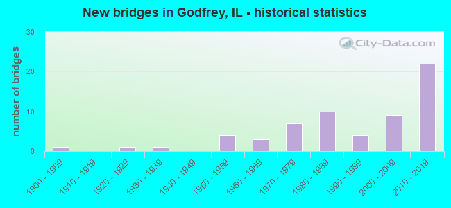
- New bridges - historical statistics
- 11900-1909
- 11920-1929
- 11930-1939
- 41950-1959
- 31960-1969
- 71970-1979
- 101980-1989
- 41990-1999
- 92000-2009
- 222010-2019

- Reconstructed bridges - Historical Statistics
- 11970-1979
- 41980-1989
- 01990-1999
- 42000-2009
- 12010-2019


- Bridge Condition - Deck
- 29.3%Very good
- 39.0%Good
- 22.0%Satisfactory
- 9.8%Fair

- Bridge Condition - Superstructure
- 2.3%Excellent
- 51.2%Very good
- 18.6%Good
- 16.3%Satisfactory
- 9.3%Fair
- 2.3%Serious

- Bridge Condition - Substructure
- 2.3%Excellent
- 46.5%Very good
- 23.3%Good
- 14.0%Satisfactory
- 11.6%Fair
- 2.3%Poor

- Bridge Condition - Channel
- 4.8%Excellent
- 21.4%Very good
- 16.7%Good
- 50.0%Satisfactory
- 4.8%Fair
- 2.4%Poor

- Bridge Condition - Culverts
- 60.0%Very good
- 30.0%Good
- 10.0%Fair
Find on map >> Show street view
Structure Number: 60301, Location: 1.1MI S JERSEY CO LN (Lat: 38.987789, Lng: -90.260531), Route carried "on" structure: Other road , Year Built: 1958, Year Reconstructed: 1987, Status: Open, Structure Length: 5.64m (18.50ft), Average Daily Traffic: 650 (year 2021), Truck Traffic: 12%, Average Future Daily Traffic: 477 (year 2032), Design Load: HS 20, Features Intersected: PIASA CREEK, Facility Carried by Structure: CH61/AIRPORT ROAD
Minimum Vertical Clearance: 30+ m (98+ ft), Kilometerpoint: 1.786, Lanes on structure: 2, Owner: County Highway Agency, Approaching Roadway Width: 6.7m (22.0ft), Material/Design: Prestressed concrete, Design/Construction: Box Beam or Girders - Multiple, Number Of Spans In Main Unit: 2, Number Of Approach Spans: 2, Length of Maximum Span: 22.9m (75.1ft), Curb-To-Curb Width: 8.2m (26.9ft), Out-to-Out Width: 8.2m (26.9ft)
Condition: Deck: Fair, Superstructure: Fair, Substructure: Poor, Channel: Satisfactory, Operating Rating: 55.7 metric tons, Method Used To Determine Operating Rating: Load Factor (LF) rating reported by rating factor (RF) method using MS18 loading, Inventory Rating: 33.4 metric tons, Method Used To Determine Inventory Rating: Load Factor (LF) rating reported by rating factor (RF) method using MS18 loading, Structural Evaluation: Meets minimum limits, Deck Geometry: Somewhat better than minimum adequacy, Waterway Adequacy: Equal to present desirable criteria, Approach Roadway Alignment: Better than present minimum criteria, Designated Inspection Frequency: Every 24 months, Inspection Date: January 2021, Deck Structure Type: Concrete Precast Panels, Wearing Surface/Protective System: Wearing Surface: Bituminous, Membrane: Built-up
Find on map >> Show street view
Structure Number: 603011, Location: 1.3MI S JERSEY CO LN (Lat: 38.985911, Lng: -90.257292), Route carried "on" structure: Other road , Year Built: 1958, Year Reconstructed: 1987, Status: Open, Structure Length: 3.77m (12.37ft), Average Daily Traffic: 650 (year 2021), Truck Traffic: 12%, Average Future Daily Traffic: 477 (year 2032), Design Load: HS 20, Features Intersected: LITTLE PIASA CREEK, Facility Carried by Structure: CH61/AIRPORT ROAD
Minimum Vertical Clearance: 30+ m (98+ ft), Kilometerpoint: 2.140, Lanes on structure: 2, Owner: County Highway Agency, Approaching Roadway Width: 6.7m (22.0ft), Material/Design: Prestressed concrete, Design/Construction: Box Beam or Girders - Multiple, Number Of Spans In Main Unit: 3, Length of Maximum Span: 24.3m (79.7ft), Curb-To-Curb Width: 8.2m (26.9ft), Out-to-Out Width: 8.2m (26.9ft)
Condition: Deck: Good, Superstructure: Good, Substructure: Fair, Channel: Satisfactory, Operating Rating: 61.2 metric tons, Method Used To Determine Operating Rating: Load Factor (LF) rating reported by rating factor (RF) method using MS18 loading, Inventory Rating: 35.0 metric tons, Method Used To Determine Inventory Rating: Load Factor (LF) rating reported by rating factor (RF) method using MS18 loading, Structural Evaluation: Somewhat better than minimum adequacy, Deck Geometry: Somewhat better than minimum adequacy, Waterway Adequacy: Equal to present desirable criteria, Approach Roadway Alignment: Equal to present desirable criteria, Designated Inspection Frequency: Every 24 months, Inspection Date: January 2021, Deck Structure Type: Concrete Precast Panels, Wearing Surface/Protective System: Wearing Surface: Bituminous, Membrane: Built-up
Find on map >> Show street view
Structure Number: 603225, Location: 1.2 MI W FOSTERBURGM (Lat: 38.972867, Lng: -90.104928), Route carried "on" structure: County highway , Year Built: 1977, Year Reconstructed: 2006, Status: Open, Structure Length: 3.55m (11.65ft), Average Daily Traffic: 475 (year 2021), Truck Traffic: 11%, Average Future Daily Traffic: 901 (year 2032), Design Load: HS 20, Features Intersected: HONEYCUT BRANCH, Facility Carried by Structure: FAS 737/SEILER RD.
Minimum Vertical Clearance: 30+ m (98+ ft), Kilometerpoint: 4.957, Lanes on structure: 2, Owner: County Highway Agency, Approaching Roadway Width: 10.7m (35.1ft), Skew: 1 degrees, Material/Design: Prestressed concrete, Design/Construction: Box Beam or Girders - Multiple, Number Of Spans In Main Unit: 3, Length of Maximum Span: 11.2m (36.7ft), Curb-To-Curb Width: 11.0m (36.1ft), Out-to-Out Width: 11.0m (36.1ft)
Condition: Deck: Fair, Superstructure: Fair, Substructure: Fair, Channel: Satisfactory, Operating Rating: 76.8 metric tons, Method Used To Determine Operating Rating: Load Factor (LF) rating reported by rating factor (RF) method using MS18 loading, Inventory Rating: 46.0 metric tons, Method Used To Determine Inventory Rating: Load Factor (LF) rating reported by rating factor (RF) method using MS18 loading, Structural Evaluation: Somewhat better than minimum adequacy, Deck Geometry: Better than present minimum criteria, Waterway Adequacy: Equal to present desirable criteria, Approach Roadway Alignment: Equal to present desirable criteria, Length Of Structure Improvement: 3.47m (11.38ft), Designated Inspection Frequency: Every 24 months, Inspection Date: Febuary 2021, Bridge Improvement Cost: $513,000,000, Roadway Improvement Cost: $14,400,000, Total Project Cost: $527,400,000, Deck Structure Type: Concrete Precast Panels, Wearing Surface/Protective System: Wearing Surface: Bituminous, Membrane: Built-up
Find on map >> Show street view
Structure Number: 603229, Location: 1.0 MI N OF ALTON (Lat: 38.939369, Lng: -90.142353), Route carried "on" structure: Other road , Year Built: 1980, Year Reconstructed: 2016, Status: Open, Structure Length: 3.38m (11.09ft), Average Daily Traffic: 5,300 (year 2021), Truck Traffic: 6%, Average Future Daily Traffic: 8,791 (year 2035), Design Load: HS 25 or greater, Features Intersected: TRIB TO HONEY BR, Facility Carried by Structure: FAU 8998/SEMINARY
Minimum Vertical Clearance: 30+ m (98+ ft), Kilometerpoint: 1.432, Lanes on structure: 2, Owner: County Highway Agency, Approaching Roadway Width: 12.4m (40.7ft), Material/Design: Steel continuous, Design/Construction: Stringer/Multi-beam, Number Of Spans In Main Unit: 3, Length of Maximum Span: 12.6m (41.3ft), Curb-To-Curb Width: 12.2m (40.0ft), Out-to-Out Width: 13.2m (43.3ft)
Condition: Deck: Very good, Superstructure: Very good, Substructure: Good, Channel: Satisfactory, Operating Rating: 75.2 metric tons, Method Used To Determine Operating Rating: Load and Resistance Factor Rating (LRFR) rating reported by rating factor(RF) method using HL-93 loadings, Inventory Rating: 56.4 metric tons, Method Used To Determine Inventory Rating: Load and Resistance Factor Rating (LRFR) rating reported by rating factor(RF) method using HL-93 loadings, Structural Evaluation: Better than present minimum criteria, Deck Geometry: Somewhat better than minimum adequacy, Waterway Adequacy: Better than present minimum criteria, Approach Roadway Alignment: Equal to present desirable criteria, Designated Inspection Frequency: Every 48 months, Inspection Date: Febuary 2021, Deck Structure Type: Concrete Cast-file-Place, Wearing Surface/Protective System: Wearing Surface: Bituminous, Membrane: Built-up, Deck Protection: Epoxy Coated Reinforcing
Find on map >> Show street view
Structure Number: 603243, Location: 2.8 MI NW GODFREY (Lat: 38.989292, Lng: -90.225475), Route carried "on" structure: City street , Year Built: 1978, Status: Open, Structure Length: 1.13m (3.71ft), Average Daily Traffic: 400 (year 2021), Truck Traffic: 8%, Average Future Daily Traffic: 530 (year 2032), Design Load: HS 20, Features Intersected: S BR LITTLE PIASA, Facility Carried by Structure: DAVIS LN/ MSS 6160
Minimum Vertical Clearance: 30+ m (98+ ft), Kilometerpoint: 0.467, Lanes on structure: 2, Owner: City or Municipal Highway Agency, Approaching Roadway Width: 5.8m (19.0ft), Skew: 1 degrees, Material/Design: Concrete, Design/Construction: Culvert, Number Of Spans In Main Unit: 3, Length of Maximum Span: 3.4m (11.2ft)
Condition: Channel: Good, Culverts: Very good, Operating Rating: 44.4 metric tons, Method Used To Determine Operating Rating: Assigned rating based on Load Factor Design (LFD) reported by rating factor (RF) using MS18 loading, Inventory Rating: 32.4 metric tons, Method Used To Determine Inventory Rating: Assigned rating based on Load Factor Design (LFD) reported by rating factor (RF) using MS18 loading, Structural Evaluation: Equal to present desirable criteria, Waterway Adequacy: Equal to present desirable criteria, Approach Roadway Alignment: Better than present minimum criteria, Designated Inspection Frequency: Every 48 months, Inspection Date: January 2022
Find on map >> Show street view
Structure Number: 603277, Location: 4.5 MILES N OF ALTON (Lat: 38.959736, Lng: -90.111619), Route carried "on" structure: County highway , Year Built: 1986, Status: Open, Structure Length: 2.35m (7.71ft), Average Daily Traffic: 100 (year 2021), Truck Traffic: 12%, Average Future Daily Traffic: 239 (year 2032), Design Load: HS 20, Features Intersected: HONEYCUT BRANCH, Facility Carried by Structure: TR 55
Minimum Vertical Clearance: 30+ m (98+ ft), Kilometerpoint: 1.287, Lanes on structure: 2, Owner: Town or Township Highway Agency, Approaching Roadway Width: 7.0m (23.0ft), Skew: 2 degrees, Material/Design: Prestressed concrete, Design/Construction: Box Beam or Girders - Multiple, Number Of Spans In Main Unit: 3, Length of Maximum Span: 7.6m (24.9ft), Curb-To-Curb Width: 8.6m (28.2ft), Out-to-Out Width: 8.6m (28.2ft)
Condition: Deck: Good, Superstructure: Good, Substructure: Fair, Channel: Satisfactory, Operating Rating: 44.4 metric tons, Method Used To Determine Operating Rating: Assigned rating based on Load Factor Design (LFD) reported by rating factor (RF) using MS18 loading, Inventory Rating: 32.4 metric tons, Method Used To Determine Inventory Rating: Assigned rating based on Load Factor Design (LFD) reported by rating factor (RF) using MS18 loading, Structural Evaluation: Somewhat better than minimum adequacy, Deck Geometry: Better than present minimum criteria, Waterway Adequacy: Equal to present desirable criteria, Approach Roadway Alignment: Equal to present desirable criteria, Designated Inspection Frequency: Every 24 months, Inspection Date: Febuary 2021, Deck Structure Type: Concrete Precast Panels, Wearing Surface/Protective System: Wearing Surface: Gravel
Find on map >> Show street view
Structure Number: 603279, Location: 4.5 MI N OF ALTON (Lat: 38.984728, Lng: -90.148233), Route carried "on" structure: County highway , Year Built: 1988, Status: Open, Structure Length: 2.50m (8.20ft), Average Daily Traffic: 150 (year 2021), Truck Traffic: 9%, Average Future Daily Traffic: 186 (year 2032), Design Load: HS 20, Features Intersected: TRIB W FRK W R CRK, Facility Carried by Structure: TR 21
Minimum Vertical Clearance: 30+ m (98+ ft), Kilometerpoint: 0.740, Lanes on structure: 2, Owner: Town or Township Highway Agency, Approaching Roadway Width: 6.4m (21.0ft), Skew: 1 degrees, Material/Design: Prestressed concrete, Design/Construction: Box Beam or Girders - Multiple, Number Of Spans In Main Unit: 3, Length of Maximum Span: 9.1m (29.9ft), Curb-To-Curb Width: 8.6m (28.2ft), Out-to-Out Width: 8.6m (28.2ft)
Condition: Deck: Satisfactory, Superstructure: Satisfactory, Substructure: Satisfactory, Channel: Satisfactory, Operating Rating: 44.4 metric tons, Method Used To Determine Operating Rating: Assigned rating based on Load Factor Design (LFD) reported by rating factor (RF) using MS18 loading, Inventory Rating: 32.4 metric tons, Method Used To Determine Inventory Rating: Assigned rating based on Load Factor Design (LFD) reported by rating factor (RF) using MS18 loading, Structural Evaluation: Equal to present minimum criteria, Deck Geometry: Equal to present minimum criteria, Waterway Adequacy: Equal to present desirable criteria, Approach Roadway Alignment: Equal to present desirable criteria, Designated Inspection Frequency: Every 24 months, Inspection Date: Febuary 2021, Deck Structure Type: Concrete Precast Panels, Wearing Surface/Protective System: Wearing Surface: Gravel
Find on map >> Show street view
Structure Number: 603282, Location: 0.15 S OF JERSEY CO (Lat: 38.997658, Lng: -90.215894), Route carried "on" structure: County highway , Year Built: 1985, Status: Open, Structure Length: 4.91m (16.11ft), Average Daily Traffic: 1,250 (year 2017), Truck Traffic: 2%, Average Future Daily Traffic: 1,113 (year 2032), Design Load: HS 20, Features Intersected: LITTLE PIASA CREEK, Facility Carried by Structure: CH 36 LAGEMAN RD
Minimum Vertical Clearance: 30+ m (98+ ft), Kilometerpoint: 0.193, Lanes on structure: 2, Owner: County Highway Agency, Approaching Roadway Width: 7.3m (24.0ft), Skew: 1 degrees, Material/Design: Prestressed concrete, Design/Construction: Box Beam or Girders - Multiple, Number Of Spans In Main Unit: 3, Length of Maximum Span: 18.3m (60.0ft), Curb-To-Curb Width: 8.6m (28.2ft), Out-to-Out Width: 8.6m (28.2ft)
Condition: Deck: Fair, Superstructure: Fair, Substructure: Fair, Channel: Satisfactory, Operating Rating: 44.4 metric tons, Method Used To Determine Operating Rating: Assigned rating based on Load Factor Design (LFD) reported by rating factor (RF) using MS18 loading, Inventory Rating: 32.4 metric tons, Method Used To Determine Inventory Rating: Assigned rating based on Load Factor Design (LFD) reported by rating factor (RF) using MS18 loading, Structural Evaluation: Somewhat better than minimum adequacy, Deck Geometry: Somewhat better than minimum adequacy, Waterway Adequacy: Equal to present desirable criteria, Approach Roadway Alignment: Equal to present desirable criteria, Designated Inspection Frequency: Every 24 months, Inspection Date: January 2021, Deck Structure Type: Concrete Precast Panels, Wearing Surface/Protective System: Wearing Surface: Bituminous, Membrane: Built-up
Find on map >> Show street view
Structure Number: 603293, Location: 4.5 NORTH OF ALTON (Lat: 38.988833, Lng: -90.117300), Route carried "on" structure: County highway , Year Built: 1990, Status: Open, Structure Length: 3.10m (10.17ft), Average Daily Traffic: 100 (year 2021), Truck Traffic: 24%, Average Future Daily Traffic: 80 (year 2032), Design Load: HS 20, Features Intersected: W. FORK WOOD RIVER, Facility Carried by Structure: STRAUBE LN/ TR 21A
Minimum Vertical Clearance: 30+ m (98+ ft), Kilometerpoint: 1.287, Lanes on structure: 2, Owner: Town or Township Highway Agency, Approaching Roadway Width: 6.7m (22.0ft), Skew: 2 degrees, Material/Design: Prestressed concrete, Design/Construction: Box Beam or Girders - Multiple, Number Of Spans In Main Unit: 3, Length of Maximum Span: 12.2m (40.0ft), Curb-To-Curb Width: 8.5m (27.9ft), Out-to-Out Width: 8.5m (27.9ft)
Condition: Deck: Fair, Superstructure: Fair, Substructure: Fair, Channel: Satisfactory, Operating Rating: 44.4 metric tons, Method Used To Determine Operating Rating: Assigned rating based on Load Factor Design (LFD) reported by rating factor (RF) using MS18 loading, Inventory Rating: 32.4 metric tons, Method Used To Determine Inventory Rating: Assigned rating based on Load Factor Design (LFD) reported by rating factor (RF) using MS18 loading, Structural Evaluation: Somewhat better than minimum adequacy, Deck Geometry: Better than present minimum criteria, Waterway Adequacy: Equal to present desirable criteria, Approach Roadway Alignment: Equal to present desirable criteria, Designated Inspection Frequency: Every 24 months, Inspection Date: Febuary 2021, Deck Structure Type: Concrete Precast Panels, Wearing Surface/Protective System: Wearing Surface: Gravel
Find on map >> Show street view
Structure Number: 603303, Location: 1MI NW ALTON (Lat: 38.947567, Lng: -90.213094), Route carried "on" structure: Other road , Year Built: 1967, Status: Open, Structure Length: 0.85m (2.79ft), Average Daily Traffic: 2,150 (year 2021), Truck Traffic: 3%, Average Future Daily Traffic: 5,724 (year 2032), Design Load: HS 20, Features Intersected: ROCKY FORK, Facility Carried by Structure: STAMPER LN/ MSS 11
Minimum Vertical Clearance: 30+ m (98+ ft), Kilometerpoint: 0.161, Lanes on structure: 2, Owner: City or Municipal Highway Agency, Approaching Roadway Width: 7.0m (23.0ft), Material/Design: Steel, Design/Construction: Culvert, Number Of Spans In Main Unit: 2, Length of Maximum Span: 3.8m (12.5ft)
Condition: Channel: Satisfactory, Culverts: Good, Operating Rating: 50.5 metric tons, Method Used To Determine Operating Rating: Load Factor (LF) rating reported by rating factor (RF) method using MS18 loading, Inventory Rating: 44.1 metric tons, Method Used To Determine Inventory Rating: Load Factor (LF) rating reported by rating factor (RF) method using MS18 loading, Structural Evaluation: Better than present minimum criteria, Waterway Adequacy: Equal to present minimum criteria, Approach Roadway Alignment: Equal to present desirable criteria, Designated Inspection Frequency: Every 24 months, Inspection Date: January 2022
Find on map >> Show street view
Structure Number: 60335, Location: .04MI S JERSEY CO (Lat: 38.999186, Lng: -90.272011), Route carried "on" structure: Other road , Year Built: 2010, Status: Open, Structure Length: 1.77m (5.81ft), Average Daily Traffic: 125 (year 2017), Truck Traffic: 16%, Average Future Daily Traffic: 265 (year 2032), Design Load: HS 20+Mod, Features Intersected: TRIB LITTLE PIASA, Facility Carried by Structure: CH 61 AIRPORT RD
Minimum Vertical Clearance: 30+ m (98+ ft), Kilometerpoint: 0.064, Lanes on structure: 2, Owner: County Highway Agency, Approaching Roadway Width: 7.6m (24.9ft), Skew: 3 degrees, Material/Design: Concrete, Design/Construction: Culvert, Number Of Spans In Main Unit: 1, Length of Maximum Span: 17.1m (56.1ft)
Condition: Channel: Good, Culverts: Very good, Operating Rating: 44.1 metric tons, Method Used To Determine Operating Rating: Assigned rating based on Load Factor Design (LFD) reported by rating factor (RF) using MS18 loading, Inventory Rating: 32.4 metric tons, Method Used To Determine Inventory Rating: Assigned rating based on Load Factor Design (LFD) reported by rating factor (RF) using MS18 loading, Structural Evaluation: Equal to present desirable criteria, Waterway Adequacy: Equal to present desirable criteria, Approach Roadway Alignment: Better than present minimum criteria, Designated Inspection Frequency: Every 48 months, Inspection Date: January 2021
Find on map >> Show street view
Structure Number: 606108, Location: N CORP LIMALTON (Lat: 38.931339, Lng: -90.179142), Route carried "on" structure: Other road , Year Built: 1979, Status: Open, Structure Length: 1.07m (3.51ft), Average Daily Traffic: 7,800 (year 2021), Truck Traffic: 6%, Average Future Daily Traffic: 10,918 (year 2032), Design Load: HS 20, Features Intersected: COAL BR, Facility Carried by Structure: ALBY RD/ FAU 8988
Minimum Vertical Clearance: 30+ m (98+ ft), Kilometerpoint: 1.513, Lanes on structure: 2, Base Highway Network: Yes, Owner: City or Municipal Highway Agency, Approaching Roadway Width: 12.2m (40.0ft), Material/Design: Steel, Design/Construction: Culvert, Number Of Spans In Main Unit: 2, Length of Maximum Span: 4.9m (16.1ft)
Condition: Channel: Satisfactory, Culverts: Fair, Operating Rating: 40.5 metric tons, Method Used To Determine Operating Rating: Field evaluation and documented engineering judgment, Inventory Rating: 24.3 metric tons, Method Used To Determine Inventory Rating: Field evaluation and documented engineering judgment, Structural Evaluation: Somewhat better than minimum adequacy, Waterway Adequacy: Equal to present desirable criteria, Approach Roadway Alignment: Equal to present desirable criteria, Designated Inspection Frequency: Every 24 months, Inspection Date: January 2022
Find on map >> Show street view
Structure Number: 606902, Location: 1.8MI NW ALTON (Lat: 38.946014, Lng: -90.214117), Route carried "on" structure: Other road , Year Built: 2010, Status: Open, Structure Length: 1.15m (3.77ft), Average Daily Traffic: 3,100 (year 2021), Truck Traffic: 4%, Average Future Daily Traffic: 3,392 (year 2032), Design Load: HS 20+Mod, Features Intersected: ROCKY FORK CK, Facility Carried by Structure: PIERCE LN/FAU 8985
Minimum Vertical Clearance: 30+ m (98+ ft), Kilometerpoint: 9.173, Lanes on structure: 2, Owner: City or Municipal Highway Agency, Approaching Roadway Width: 7.9m (25.9ft), Skew: 3 degrees, Material/Design: Concrete, Design/Construction: Frame, Number Of Spans In Main Unit: 1, Length of Maximum Span: 11.5m (37.7ft), Curb-To-Curb Width: 9.1m (29.9ft), Out-to-Out Width: 17.0m (55.8ft)
Condition: Superstructure: Excellent, Substructure: Excellent, Channel: Very good, Operating Rating: 44.1 metric tons, Method Used To Determine Operating Rating: Assigned rating based on Load Factor Design (LFD) reported by rating factor (RF) using MS18 loading, Inventory Rating: 32.4 metric tons, Method Used To Determine Inventory Rating: Assigned rating based on Load Factor Design (LFD) reported by rating factor (RF) using MS18 loading, Structural Evaluation: Equal to present desirable criteria, Deck Geometry: Meets minimum limits, Waterway Adequacy: Equal to present desirable criteria, Approach Roadway Alignment: Equal to present desirable criteria, Designated Inspection Frequency: Every 48 months, Inspection Date: January 2020, Deck Structure Type: Other
Find on map >> Show street view
Structure Number: 600118, Location: 1 M E JCT 111 (Lat: 38.922575, Lng: -90.180989), Route carried "under" structure: US 67, Year Built: 1958, Structure Length: 0. m, Average Daily Traffic: 9,750 (year 2021), Truck Traffic: 5%, Features Intersected: US 67, Facility Carried by Structure: IL 111 - HOMER ADA
Minimum Vertical Clearance: 5.59m (18.34ft), Kilometerpoint: 6.872, Lanes on structure: 4, Lanes under structure: 2, Material/Design: Steel continuous, Design/Construction: Stringer/Multi-beam, Length of Maximum Span: 39.9m (130.9ft)
Find on map >> Show street view
Structure Number: 600304, Location: 1.5MI S SEILER RD (Lat: 38.948069, Lng: -90.141817), Route carried "under" structure: Other road , Year Built: 2006, Structure Length: 0. m, Average Daily Traffic: 5,300 (year 2021), Truck Traffic: 6%, Features Intersected: FAS 1765 SEMINARY RD, Facility Carried by Structure: IL 255 NB (FAP310N
Minimum Vertical Clearance: 5.36m (17.59ft), Kilometerpoint: 0.467, Lanes on structure: 2, Lanes under structure: 2, Material/Design: Steel, Design/Construction: Stringer/Multi-beam, Length of Maximum Span: 33.4m (109.6ft)
Find on map >> Show street view
Structure Number: 600305, Location: 1.5MI S SEILER RD (Lat: 38.947858, Lng: -90.141844), Route carried "under" structure: Other road , Year Built: 2006, Structure Length: 0. m, Average Daily Traffic: 5,300 (year 2021), Truck Traffic: 6%, Features Intersected: FAS 1765 SEMINARY RD, Facility Carried by Structure: IL 255 SB (FAP310S
Minimum Vertical Clearance: 5.36m (17.59ft), Kilometerpoint: 0.483, Lanes on structure: 2, Lanes under structure: 2, Material/Design: Steel, Design/Construction: Stringer/Multi-beam, Length of Maximum Span: 33.0m (108.3ft)
Find on map >> Show street view
Structure Number: 600306, Location: 1.1MI NW SEMINARY RD (Lat: 38.951700, Lng: -90.160742), Route carried "under" structure: State highway 255, Year Built: 2010, Structure Length: 0. m, Average Daily Traffic: 14,000 (year 2021), Truck Traffic: 10%, Features Intersected: IL 255 FAP 310, Facility Carried by Structure: WENZEL RD MSS 6925
Minimum Vertical Clearance: 5.72m (18.77ft), Kilometerpoint: 28.179, Lanes on structure: 2, Lanes under structure: 4, Material/Design: Steel continuous, Design/Construction: Stringer/Multi-beam, Length of Maximum Span: 29.0m (95.1ft)
Find on map >> Show street view
Structure Number: 600308, Location: 2.8MI W OF SEMINARY (Lat: 38.963950, Lng: -90.180869), Route carried "under" structure: Other road , Year Built: 2012, Structure Length: 0. m, Average Daily Traffic: 9,150 (year 2021), Truck Traffic: 5%, Features Intersected: HUMBERT RD (CH 4), Facility Carried by Structure: IL 255 NB
Minimum Vertical Clearance: 5.84m (19.16ft), Kilometerpoint: 1.046, Lanes on structure: 2, Lanes under structure: 4, Material/Design: Steel, Design/Construction: Stringer/Multi-beam, Length of Maximum Span: 45.0m (147.6ft)
Find on map >> Show street view
Structure Number: 600309, Location: 2.8MI W OF SEMINARY (Lat: 38.963950, Lng: -90.180869), Route carried "under" structure: Other road , Year Built: 2012, Structure Length: 0. m, Average Daily Traffic: 9,150 (year 2021), Truck Traffic: 5%, Features Intersected: HUMBERT RD (CH 4), Facility Carried by Structure: IL 255 SB
Minimum Vertical Clearance: 5.84m (19.16ft), Kilometerpoint: 1.046, Lanes on structure: 2, Lanes under structure: 4, Material/Design: Steel, Design/Construction: Stringer/Multi-beam, Length of Maximum Span: 45.0m (147.6ft)
Find on map >> Show street view
Structure Number: 60033, Location: at GODFREY (Lat: 38.970375, Lng: -90.189275), Route carried "under" structure: State highway 111, Year Built: 2012, Structure Length: 0. m, Average Daily Traffic: 7,900 (year 2021), Truck Traffic: 5%, Features Intersected: IL 111/IL 267, Facility Carried by Structure: IL 255 NB - FAP 31
Minimum Vertical Clearance: 5.21m (17.09ft), Kilometerpoint: 54.201, Lanes on structure: 2, Lanes under structure: 4, Material/Design: Steel, Design/Construction: Stringer/Multi-beam, Length of Maximum Span: 43.0m (141.1ft)
Find on map >> Show street view
Structure Number: 600331, Location: at GODFREY (Lat: 38.970261, Lng: -90.189547), Route carried "under" structure: State highway 111, Year Built: 2012, Structure Length: 0. m, Average Daily Traffic: 7,900 (year 2021), Truck Traffic: 5%, Features Intersected: IL 111/IL 267, Facility Carried by Structure: IL 255 SB - FAP 31
Minimum Vertical Clearance: 5.21m (17.09ft), Kilometerpoint: 54.185, Lanes on structure: 2, Lanes under structure: 4, Material/Design: Steel, Design/Construction: Stringer/Multi-beam, Length of Maximum Span: 43.0m (141.1ft)
Find on map >> Show street view
Structure Number: 600332, Location: at GODFREY (Lat: 38.975828, Lng: -90.195256), Route carried "under" structure: State highway 255, Year Built: 2012, Structure Length: 0. m, Average Daily Traffic: 6,950 (year 2021), Truck Traffic: 10%, Features Intersected: IL 255 NB & SB, Facility Carried by Structure: US 67 NB
Minimum Vertical Clearance: 5.59m (18.34ft), Kilometerpoint: 32.942, Lanes on structure: 1, Lanes under structure: 4, Material/Design: Steel continuous, Design/Construction: Stringer/Multi-beam, Length of Maximum Span: 66.9m (219.5ft)