Bridge Statistics for Goldsboro, North Carolina (NC)
Condition, Traffic, Stress, Structural Evaluation, Project Costs
- National Bridge Inventory (NBI) Statistics
- 181Number of bridges
- 2,352ft / 717mTotal length
- $75,000Total costs
- 1,645,302Total average daily traffic
- 181,338Total average daily truck traffic
- National Bridge Inventory (NBI) Registered Bridges for Goldsboro
- No street view available for this location
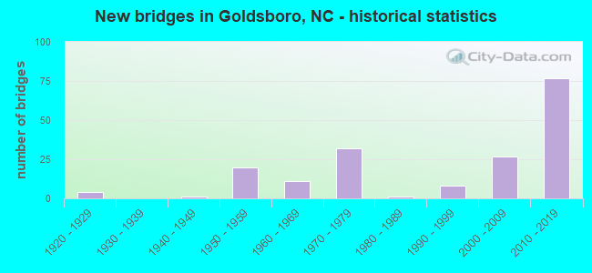
- New bridges - historical statistics
- 41920-1929
- 11940-1949
- 201950-1959
- 111960-1969
- 321970-1979
- 11980-1989
- 81990-1999
- 272000-2009
- 772010-2019
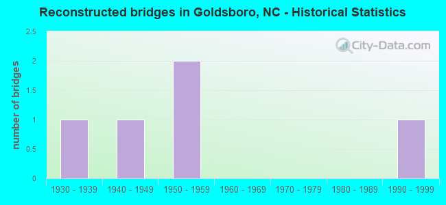
- Reconstructed bridges - Historical Statistics
- 11930-1939
- 11940-1949
- 21950-1959
- 01960-1969
- 01970-1979
- 01980-1989
- 11990-1999
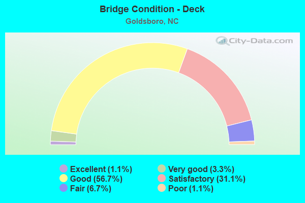
- Bridge Condition - Deck
- 1.1%Excellent
- 3.3%Very good
- 56.7%Good
- 31.1%Satisfactory
- 6.7%Fair
- 1.1%Poor
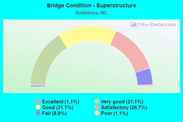
- Bridge Condition - Superstructure
- 1.1%Excellent
- 31.1%Very good
- 31.1%Good
- 26.7%Satisfactory
- 8.9%Fair
- 1.1%Poor
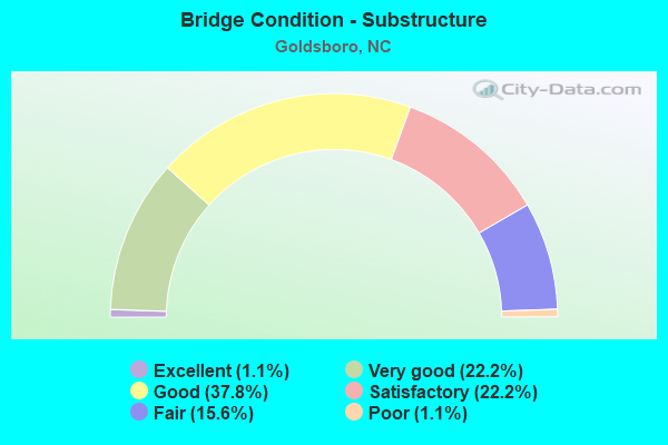
- Bridge Condition - Substructure
- 1.1%Excellent
- 22.2%Very good
- 37.8%Good
- 22.2%Satisfactory
- 15.6%Fair
- 1.1%Poor
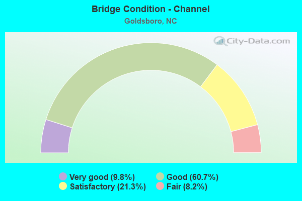
- Bridge Condition - Channel
- 9.8%Very good
- 60.7%Good
- 21.3%Satisfactory
- 8.2%Fair
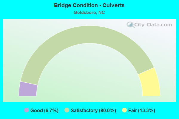
- Bridge Condition - Culverts
- 6.7%Good
- 80.0%Satisfactory
- 13.3%Fair
Find on map >> Show street view
Structure Number: 1910365, Location: 0.9 MI. E. JCT. US117 (Lat: 35.426356, Lng: -77.963653), Route carried "on" structure: Bypass US 70, Year Built: 2012, Status: Open, Structure Length: 3.04m (9.97ft), Average Daily Traffic: 13,500 (year 2018), Truck Traffic: 12%, Average Future Daily Traffic: 27,000 (year 2040), Design Load: HS 25 or greater, Features Intersected: NC111
Minimum Vertical Clearance: 30.44m (99.87ft), Kilometerpoint: 0.000, Lanes on structure: 2, Lanes under structure: 2, Base Highway Network: Yes (Inventory Route: 2, Subroute: 70), Owner: State Highway Agency, Approaching Roadway Width: 11.5m (37.7ft), Skew: 10 degrees, Material/Design: Prestressed concrete continuous, Design/Construction: Stringer/Multi-beam, Number Of Spans In Main Unit: 1, Length of Maximum Span: 29.5m (96.8ft), Curb-To-Curb Width: 11.3m (37.1ft), Out-to-Out Width: 12.3m (40.4ft)
Condition: Deck: Good, Superstructure: Very good, Substructure: Good, Operating Rating: 89.8 metric tons, Method Used To Determine Operating Rating: Load Factor (LF), Inventory Rating: 55.3 metric tons, Method Used To Determine Inventory Rating: Load Factor (LF), Structural Evaluation: Better than present minimum criteria, Deck Geometry: Somewhat better than minimum adequacy, Underclear: High priority of corrective action, Approach Roadway Alignment: Equal to present desirable criteria, Designated Inspection Frequency: Every 24 months, Inspection Date: Febuary 2022, Deck Structure Type: Concrete Cast-file-Place, Wearing Surface/Protective System: Wearing Surface: Integral Concrete, Deck Protection: Epoxy Coated Reinforcing
Find on map >> Show street view
Structure Number: 1910366, Location: 0.7 MI.E. JCT. NC111 (Lat: 35.423911, Lng: -77.949314), Route carried "on" structure: Bypass US 70, Year Built: 2012, Status: Open, Structure Length: 16.85m (55.28ft), Average Daily Traffic: 13,500 (year 2018), Truck Traffic: 12%, Average Future Daily Traffic: 27,000 (year 2040), Design Load: HS 25 or greater, Features Intersected: STONEY CREEK
Minimum Vertical Clearance: 30.44m (99.87ft), Kilometerpoint: 109.089, Lanes on structure: 2, Base Highway Network: Yes (Inventory Route: 2, Subroute: 70), Owner: State Highway Agency, Approaching Roadway Width: 10.9m (35.8ft), Skew: 10 degrees, Material/Design: Prestressed concrete continuous, Design/Construction: Stringer/Multi-beam, Number Of Spans In Main Unit: 5, Number Of Approach Spans: 2, Length of Maximum Span: 35.3m (115.8ft), Curb-To-Curb Width: 11.3m (37.1ft), Out-to-Out Width: 12.2m (40.0ft)
Condition: Deck: Good, Superstructure: Very good, Substructure: Very good, Channel: Very good, Operating Rating: 89.8 metric tons, Method Used To Determine Operating Rating: Load Factor (LF), Inventory Rating: 43.5 metric tons, Method Used To Determine Inventory Rating: Load Factor (LF), Structural Evaluation: Equal to present desirable criteria, Deck Geometry: Somewhat better than minimum adequacy, Waterway Adequacy: Equal to present desirable criteria, Approach Roadway Alignment: Equal to present desirable criteria, Designated Inspection Frequency: Every 24 months, Inspection Date: Febuary 2022, Deck Structure Type: Concrete Cast-file-Place, Wearing Surface/Protective System: Wearing Surface: Monolithic Concrete, Deck Protection: Epoxy Coated Reinforcing
Find on map >> Show street view
Structure Number: 1910367, Location: 0.7 MI.E. OF JCT.NC111 (Lat: 35.423725, Lng: -77.949378), Route carried "on" structure: Bypass Interstate 70, Year Built: 2012, Status: Open, Structure Length: 16.85m (55.28ft), Average Daily Traffic: 10,750 (year 2018), Truck Traffic: 12%, Average Future Daily Traffic: 21,500 (year 2040), Design Load: HS 25 or greater, Features Intersected: STONEY CREEK
Minimum Vertical Clearance: 30.44m (99.87ft), Kilometerpoint: 109.089, Lanes on structure: 2, Base Highway Network: Yes (Inventory Route: 1, Subroute: 70), Owner: State Highway Agency, Approaching Roadway Width: 11.2m (36.7ft), Skew: 10 degrees, Material/Design: Prestressed concrete continuous, Design/Construction: Stringer/Multi-beam, Number Of Spans In Main Unit: 5, Length of Maximum Span: 35.3m (115.8ft), Curb-To-Curb Width: 11.3m (37.1ft), Out-to-Out Width: 12.2m (40.0ft)
Condition: Deck: Good, Superstructure: Very good, Substructure: Very good, Channel: Very good, Operating Rating: 89.8 metric tons, Method Used To Determine Operating Rating: Load Factor (LF), Inventory Rating: 43.5 metric tons, Method Used To Determine Inventory Rating: Load Factor (LF), Structural Evaluation: Equal to present desirable criteria, Deck Geometry: Somewhat better than minimum adequacy, Waterway Adequacy: Equal to present desirable criteria, Approach Roadway Alignment: Equal to present desirable criteria, Designated Inspection Frequency: Every 24 months, Inspection Date: Febuary 2022, Deck Structure Type: Concrete Cast-file-Place, Wearing Surface/Protective System: Wearing Surface: Monolithic Concrete, Deck Protection: Epoxy Coated Reinforcing
Find on map >> Show street view
Structure Number: 1910368, Location: 0.5 MI. S. JCT. SR1547 (Lat: 35.418833, Lng: -77.934864), Route carried "on" structure: State highway 1556, Year Built: 2011, Status: Open, Structure Length: 5.79m (19.00ft), Average Daily Traffic: 14,000 (year 2018), Truck Traffic: 6%, Average Future Daily Traffic: 28,000 (year 2040), Design Load: HS 25 or greater, Features Intersected: US70 BYP
Minimum Vertical Clearance: 30+ m (98+ ft), Kilometerpoint: 0.000, Lanes on structure: 2, Lanes under structure: 4, Owner: State Highway Agency, Approaching Roadway Width: 13.7m (44.9ft), Skew: 1 degrees, Material/Design: Prestressed concrete continuous, Design/Construction: Stringer/Multi-beam, Number Of Spans In Main Unit: 2, Number Of Approach Spans: 2, Length of Maximum Span: 28.3m (92.8ft), Curb-To-Curb Width: 17.9m (58.7ft), Out-to-Out Width: 18.9m (62.0ft)
Condition: Deck: Good, Superstructure: Very good, Substructure: Good, Operating Rating: 82.5 metric tons, Method Used To Determine Operating Rating: Load Factor (LF), Inventory Rating: 48.9 metric tons, Method Used To Determine Inventory Rating: Load Factor (LF), Structural Evaluation: Better than present minimum criteria, Deck Geometry: Superior to present desirable criteria, Underclear: Somewhat better than minimum adequacy, Approach Roadway Alignment: Equal to present desirable criteria, Designated Inspection Frequency: Every 24 months, Inspection Date: June 2021, Deck Structure Type: Concrete Cast-file-Place, Wearing Surface/Protective System: Wearing Surface: Monolithic Concrete, Deck Protection: Epoxy Coated Reinforcing
Find on map >> Show street view
Structure Number: 1910371, Location: .1 MI. WEST OF JCT SR1909 (Lat: 35.327111, Lng: -77.951672), Route carried "on" structure: State highway 1910, Year Built: 1962, Status: Open, Structure Length: 0.79m (2.59ft), Average Daily Traffic: 160 (year 2016), Truck Traffic: 7%, Average Future Daily Traffic: 320 (year 2040), Design Load: HS 20+Mod, Features Intersected: BUNN'S BRANCH
Minimum Vertical Clearance: 30+ m (98+ ft), Kilometerpoint: 0.000, Lanes on structure: 2, Owner: State Highway Agency, Approaching Roadway Width: 6.0m (19.7ft), Material/Design: Steel, Design/Construction: Culvert, Number Of Spans In Main Unit: 3, Length of Maximum Span: 2.1m (6.9ft)
Condition: Channel: Satisfactory, Culverts: Satisfactory, Operating Rating: 89.8 metric tons, Method Used To Determine Operating Rating: Load and Resistance Factor (LRFR), Inventory Rating: 89.8 metric tons, Method Used To Determine Inventory Rating: Load and Resistance Factor (LRFR), Structural Evaluation: Equal to present minimum criteria, Waterway Adequacy: Better than present minimum criteria, Approach Roadway Alignment: Equal to present desirable criteria, Designated Inspection Frequency: Every 24 months, Inspection Date: October 2021
Find on map >> Show street view
Structure Number: 1910372, Location: 0.1 MI. E. JCT. SR1710 (Lat: 35.333981, Lng: -77.947808), Route carried "on" structure: State highway 1961, Year Built: 1962, Status: Open, Structure Length: 0.85m (2.79ft), Average Daily Traffic: 3,000 (year 2019), Truck Traffic: 7%, Average Future Daily Traffic: 6,000 (year 2040), Design Load: HS 20+Mod, Features Intersected: BRANCH OF NEUSE RIVER
Minimum Vertical Clearance: 30+ m (98+ ft), Kilometerpoint: 0.000, Lanes on structure: 2, Owner: State Highway Agency, Approaching Roadway Width: 6.0m (19.7ft), Skew: 1 degrees, Material/Design: Steel, Design/Construction: Culvert, Number Of Spans In Main Unit: 3, Length of Maximum Span: 2.1m (6.9ft)
Condition: Channel: Satisfactory, Culverts: Satisfactory, Operating Rating: 89.8 metric tons, Method Used To Determine Operating Rating: Load and Resistance Factor (LRFR), Inventory Rating: 89.8 metric tons, Method Used To Determine Inventory Rating: Load and Resistance Factor (LRFR), Structural Evaluation: Equal to present minimum criteria, Waterway Adequacy: Better than present minimum criteria, Approach Roadway Alignment: Equal to present desirable criteria, Designated Inspection Frequency: Every 24 months, Inspection Date: October 2021
Find on map >> Show street view
Structure Number: 1910373, Location: @ JCT. US70 & NC44 (Lat: 35.433333, Lng: -78.066667), Route carried "on" structure: US 70, Year Built: 2014, Status: Open, Structure Length: 10.85m (35.60ft), Average Daily Traffic: 6,000 (year 2016), Truck Traffic: 12%, Average Future Daily Traffic: 12,000 (year 2040), Design Load: HS 20+Mod, Features Intersected: NC44
Minimum Vertical Clearance: 30+ m (98+ ft), Kilometerpoint: 0.000, Lanes on structure: 2, Lanes under structure: 4, Base Highway Network: Yes (Inventory Route: 2, Subroute: 70), Owner: State Highway Agency, Approaching Roadway Width: 9.7m (31.8ft), Skew: 9 degrees, Material/Design: Steel continuous, Design/Construction: Stringer/Multi-beam, Number Of Spans In Main Unit: 2, Length of Maximum Span: 58.2m (190.9ft), Curb-To-Curb Width: 11.3m (37.1ft), Out-to-Out Width: 12.3m (40.4ft)
Condition: Deck: Good, Superstructure: Very good, Substructure: Very good, Operating Rating: 63.5 metric tons, Method Used To Determine Operating Rating: Load Factor (LF), Inventory Rating: 37.1 metric tons, Method Used To Determine Inventory Rating: Load Factor (LF), Structural Evaluation: Equal to present desirable criteria, Deck Geometry: Equal to present minimum criteria, Underclear: Equal to present minimum criteria, Approach Roadway Alignment: Equal to present desirable criteria, Designated Inspection Frequency: Every 24 months, Inspection Date: May 2021, Deck Structure Type: Concrete Cast-file-Place, Wearing Surface/Protective System: Wearing Surface: Monolithic Concrete, Deck Protection: Epoxy Coated Reinforcing
Find on map >> Show street view
Structure Number: 1910374, Location: 0.5 MI. N US70 (Lat: 35.433100, Lng: -78.056600), Route carried "on" structure: State highway 581, Year Built: 2014, Status: Open, Structure Length: 6.27m (20.57ft), Average Daily Traffic: 6,200 (year 2012), Truck Traffic: 6%, Average Future Daily Traffic: 12,400 (year 2025), Design Load: HS 20+Mod, Features Intersected: US70BYP
Minimum Vertical Clearance: 30+ m (98+ ft), Kilometerpoint: 0.000, Lanes on structure: 3, Lanes under structure: 5, Owner: State Highway Agency, Approaching Roadway Width: 15.5m (50.9ft), Skew: 2 degrees, Material/Design: Prestressed concrete continuous, Design/Construction: Stringer/Multi-beam, Number Of Spans In Main Unit: 2, Length of Maximum Span: 31.3m (102.7ft), Curb-To-Curb Width: 20.3m (66.6ft), Out-to-Out Width: 21.3m (69.9ft)
Condition: Deck: Good, Superstructure: Very good, Substructure: Very good, Operating Rating: 89.8 metric tons, Method Used To Determine Operating Rating: Load Factor (LF), Inventory Rating: 54.4 metric tons, Method Used To Determine Inventory Rating: Load Factor (LF), Structural Evaluation: Equal to present desirable criteria, Deck Geometry: Superior to present desirable criteria, Underclear: Equal to present minimum criteria, Approach Roadway Alignment: Equal to present desirable criteria, Designated Inspection Frequency: Every 24 months, Inspection Date: August 2020, Deck Structure Type: Concrete Cast-file-Place, Wearing Surface/Protective System: Wearing Surface: Monolithic Concrete, Deck Protection: Epoxy Coated Reinforcing
Find on map >> Show street view
Structure Number: 1910375, Location: 1 MI. W. JCT. I795 (Lat: 35.426389, Lng: -78.017500), Route carried "on" structure: Bypass US 70, Year Built: 2015, Status: Open, Structure Length: 78.02m (255.97ft), Average Daily Traffic: 13,500 (year 2018), Truck Traffic: 12%, Average Future Daily Traffic: 27,000 (year 2040), Design Load: HS 25 or greater, Features Intersected: SR1326, LITTLE RIVER
Minimum Vertical Clearance: 30+ m (98+ ft), Kilometerpoint: 0.000, Lanes on structure: 2, Lanes under structure: 2, Base Highway Network: Yes (Inventory Route: 2, Subroute: 70), Owner: State Highway Agency, Approaching Roadway Width: 10.9m (35.8ft), Skew: 11 degrees, Material/Design: Prestressed concrete continuous, Design/Construction: Tee Beam, Number Of Spans In Main Unit: 22, Length of Maximum Span: 35.3m (115.8ft), Curb-To-Curb Width: 11.1m (36.4ft), Out-to-Out Width: 12.3m (40.4ft)
Condition: Deck: Good, Superstructure: Good, Substructure: Good, Channel: Good, Operating Rating: 89.8 metric tons, Method Used To Determine Operating Rating: Load Factor (LF), Inventory Rating: 58.9 metric tons, Method Used To Determine Inventory Rating: Load Factor (LF), Structural Evaluation: Better than present minimum criteria, Deck Geometry: Somewhat better than minimum adequacy, Underclear: Equal to present minimum criteria, Waterway Adequacy: Better than present minimum criteria, Approach Roadway Alignment: Equal to present desirable criteria, Designated Inspection Frequency: Every 24 months, Inspection Date: August 2020, Deck Structure Type: Concrete Cast-file-Place, Wearing Surface/Protective System: Wearing Surface: Monolithic Concrete, Deck Protection: Epoxy Coated Reinforcing
Find on map >> Show street view
Structure Number: 1910376, Location: 1 MI.W. JCT. I795 (Lat: 35.426111, Lng: -78.017500), Route carried "on" structure: Bypass Interstate 70, Year Built: 2015, Status: Open, Structure Length: 77.66m (254.79ft), Average Daily Traffic: 13,500 (year 2018), Truck Traffic: 12%, Average Future Daily Traffic: 27,000 (year 2040), Design Load: HS 25 or greater, Features Intersected: SR1326, LITTLE RIVER
Minimum Vertical Clearance: 30+ m (98+ ft), Kilometerpoint: 107.900, Lanes on structure: 2, Lanes under structure: 2, Base Highway Network: Yes (Inventory Route: 1, Subroute: 70), Owner: State Highway Agency, Approaching Roadway Width: 11.2m (36.7ft), Skew: 11 degrees, Material/Design: Prestressed concrete continuous, Design/Construction: Tee Beam, Number Of Spans In Main Unit: 22, Number Of Approach Spans: 11, Length of Maximum Span: 35.3m (115.8ft), Curb-To-Curb Width: 11.1m (36.4ft), Out-to-Out Width: 12.3m (40.4ft)
Condition: Deck: Good, Superstructure: Good, Substructure: Good, Channel: Good, Operating Rating: 89.8 metric tons, Method Used To Determine Operating Rating: Load Factor (LF), Inventory Rating: 58.9 metric tons, Method Used To Determine Inventory Rating: Load Factor (LF), Structural Evaluation: Better than present minimum criteria, Deck Geometry: Somewhat better than minimum adequacy, Underclear: Better than present minimum criteria, Waterway Adequacy: Better than present minimum criteria, Approach Roadway Alignment: Equal to present desirable criteria, Designated Inspection Frequency: Every 24 months, Inspection Date: August 2020, Deck Structure Type: Concrete Cast-file-Place, Wearing Surface/Protective System: Wearing Surface: Monolithic Concrete, Membrane: Built-up, Deck Protection: Epoxy Coated Reinforcing
Find on map >> Show street view
Structure Number: 1910377, Location: 0.4 MI. E. JCT. US70W (Lat: 35.428333, Lng: -77.996667), Route carried "on" structure: Bypass US 70, Year Built: 2015, Status: Open, Structure Length: 15.75m (51.67ft), Average Daily Traffic: 6,875 (year 2018), Truck Traffic: 16%, Average Future Daily Traffic: 13,750 (year 2040), Design Load: HS 25 or greater, Features Intersected: US70E, US70W,SR1300
Minimum Vertical Clearance: 4.78m (15.68ft), Kilometerpoint: 108.260, Lanes on structure: 2, Lanes under structure: 7, Owner: State Highway Agency, Approaching Roadway Width: 11.8m (38.7ft), Skew: 1 degrees, Material/Design: Steel continuous, Design/Construction: Stringer/Multi-beam, Number Of Spans In Main Unit: 4, Length of Maximum Span: 46.3m (151.9ft), Curb-To-Curb Width: 11.8m (38.7ft), Out-to-Out Width: 12.9m (42.3ft)
Condition: Deck: Good, Superstructure: Good, Substructure: Good, Operating Rating: 76.2 metric tons, Method Used To Determine Operating Rating: Load Factor (LF), Inventory Rating: 45.3 metric tons, Method Used To Determine Inventory Rating: Load Factor (LF), Structural Evaluation: Better than present minimum criteria, Deck Geometry: Equal to present minimum criteria, Underclear: High priority of corrective action, Approach Roadway Alignment: Equal to present desirable criteria, Designated Inspection Frequency: Every 24 months, Inspection Date: August 2020, Deck Structure Type: Concrete Cast-file-Place, Wearing Surface/Protective System: Wearing Surface: Monolithic Concrete, Deck Protection: Epoxy Coated Reinforcing
Find on map >> Show street view
Structure Number: 1910378, Location: 0.5 MI. N. JCT I795 (Lat: 35.427969, Lng: -77.996778), Route carried "on" structure: State highway 1300, Year Built: 2013, Status: Open, Structure Length: 14.20m (46.59ft), Average Daily Traffic: 4,300 (year 2018), Truck Traffic: 7%, Average Future Daily Traffic: 8,300 (year 2040), Design Load: HS 20+Mod, Features Intersected: US70BYP
Minimum Vertical Clearance: 30+ m (98+ ft), Kilometerpoint: 0.000, Lanes on structure: 2, Lanes under structure: 7, Owner: State Highway Agency, Approaching Roadway Width: 10.0m (32.8ft), Material/Design: Steel continuous, Design/Construction: Stringer/Multi-beam, Number Of Spans In Main Unit: 3, Number Of Approach Spans: 2, Length of Maximum Span: 54.5m (178.8ft), Curb-To-Curb Width: 9.6m (31.5ft), Out-to-Out Width: 10.5m (34.4ft)
Condition: Deck: Good, Superstructure: Very good, Substructure: Very good, Operating Rating: 89.8 metric tons, Method Used To Determine Operating Rating: Load Factor (LF), Inventory Rating: 87.9 metric tons, Method Used To Determine Inventory Rating: Load Factor (LF), Structural Evaluation: Equal to present desirable criteria, Deck Geometry: Meets minimum limits, Underclear: Equal to present minimum criteria, Approach Roadway Alignment: Equal to present desirable criteria, Designated Inspection Frequency: Every 24 months, Inspection Date: November 2021, Deck Structure Type: Concrete Cast-file-Place, Wearing Surface/Protective System: Wearing Surface: Monolithic Concrete, Deck Protection: Epoxy Coated Reinforcing
Find on map >> Show street view
Structure Number: 1910379, Location: 0.3 MI.W.JCT.SR1556 (Lat: 35.418017, Lng: -77.927022), Route carried "on" structure: Bypass US 70, Year Built: 2016, Status: Open, Structure Length: 11.09m (36.38ft), Average Daily Traffic: 2,100 (year 2012), Truck Traffic: 12%, Average Future Daily Traffic: 4,200 (year 2040), Design Load: HL 93, Features Intersected: REEDY BRANCH
Minimum Vertical Clearance: 30+ m (98+ ft), Kilometerpoint: 109.455, Lanes on structure: 2, Base Highway Network: Yes (Inventory Route: 2, Subroute: 70), Owner: State Highway Agency, Approaching Roadway Width: 12.1m (39.7ft), Skew: 2 degrees, Material/Design: Prestressed concrete, Design/Construction: Stringer/Multi-beam, Number Of Spans In Main Unit: 3, Length of Maximum Span: 35.9m (117.8ft), Curb-To-Curb Width: 12.1m (39.7ft), Out-to-Out Width: 13.1m (43.0ft)
Condition: Deck: Good, Superstructure: Very good, Substructure: Very good, Channel: Good, Operating Rating: 62.5 metric tons, Method Used To Determine Operating Rating: Load and Resistance Factor (LRFR), Inventory Rating: 47.1 metric tons, Method Used To Determine Inventory Rating: Load and Resistance Factor (LRFR), Structural Evaluation: Equal to present desirable criteria, Deck Geometry: Equal to present minimum criteria, Waterway Adequacy: Better than present minimum criteria, Approach Roadway Alignment: Equal to present desirable criteria, Designated Inspection Frequency: Every 24 months, Inspection Date: August 2020, Deck Structure Type: Concrete Cast-file-Place, Wearing Surface/Protective System: Wearing Surface: Monolithic Concrete, Deck Protection: Epoxy Coated Reinforcing
Find on map >> Show street view
Structure Number: 191038, Location: 0.3 MI.E.JCT.SR1556 (Lat: 35.417889, Lng: -77.927064), Route carried "on" structure: US 70, Year Built: 2016, Status: Open, Structure Length: 11.09m (36.38ft), Average Daily Traffic: 2,100 (year 2012), Truck Traffic: 12%, Average Future Daily Traffic: 4,200 (year 2040), Design Load: HL 93, Features Intersected: REEDY BRANCH
Minimum Vertical Clearance: 30+ m (98+ ft), Kilometerpoint: 109.455, Lanes on structure: 3, Base Highway Network: Yes, Owner: State Highway Agency, Approaching Roadway Width: 14.6m (47.9ft), Skew: 12 degrees, Material/Design: Prestressed concrete, Design/Construction: Stringer/Multi-beam, Number Of Spans In Main Unit: 3, Length of Maximum Span: 35.9m (117.8ft), Curb-To-Curb Width: 14.6m (47.9ft), Out-to-Out Width: 15.6m (51.2ft)
Condition: Deck: Good, Superstructure: Very good, Substructure: Very good, Channel: Good, Operating Rating: 64.4 metric tons, Method Used To Determine Operating Rating: Load and Resistance Factor (LRFR), Inventory Rating: 48.9 metric tons, Method Used To Determine Inventory Rating: Load and Resistance Factor (LRFR), Structural Evaluation: Equal to present desirable criteria, Deck Geometry: Meets minimum limits, Waterway Adequacy: Better than present minimum criteria, Approach Roadway Alignment: Equal to present desirable criteria, Designated Inspection Frequency: Every 24 months, Inspection Date: August 2020, Deck Structure Type: Concrete Cast-file-Place, Wearing Surface/Protective System: Wearing Surface: Bituminous, Deck Protection: Epoxy Coated Reinforcing
Find on map >> Show street view
Structure Number: 1910381, Location: 1.2 M E JCT SR 1714 (Lat: 35.363842, Lng: -77.853358), Route carried "on" structure: Bypass US 70, Year Built: 2016, Status: Open, Structure Length: 18.28m (59.97ft), Average Daily Traffic: 6,500 (year 2018), Truck Traffic: 14%, Average Future Daily Traffic: 13,000 (year 2040), Design Load: HL 93, Features Intersected: WEST BEAR CREEK
Minimum Vertical Clearance: 30+ m (98+ ft), Kilometerpoint: 111.344, Lanes on structure: 2, Base Highway Network: Yes, Owner: State Highway Agency, Approaching Roadway Width: 12.8m (42.0ft), Skew: 6 degrees, Material/Design: Prestressed concrete, Design/Construction: Stringer/Multi-beam, Number Of Spans In Main Unit: 5, Number Of Approach Spans: 2, Length of Maximum Span: 37.4m (122.7ft), Curb-To-Curb Width: 12.0m (39.4ft), Out-to-Out Width: 13.1m (43.0ft)
Condition: Deck: Good, Superstructure: Good, Substructure: Good, Channel: Very good, Operating Rating: 73.4 metric tons, Method Used To Determine Operating Rating: Load and Resistance Factor (LRFR), Inventory Rating: 49.8 metric tons, Method Used To Determine Inventory Rating: Load and Resistance Factor (LRFR), Structural Evaluation: Better than present minimum criteria, Deck Geometry: Better than present minimum criteria, Waterway Adequacy: Equal to present desirable criteria, Approach Roadway Alignment: Equal to present desirable criteria, Designated Inspection Frequency: Every 24 months, Inspection Date: July 2020, Deck Structure Type: Concrete Cast-file-Place, Wearing Surface/Protective System: Wearing Surface: Monolithic Concrete, Deck Protection: Epoxy Coated Reinforcing
Find on map >> Show street view
Structure Number: 1910382, Location: 1.2 MI. E. OF JCT. SR1714 (Lat: 35.364167, Lng: -77.853889), Route carried "on" structure: Bypass US 70, Year Built: 2016, Status: Open, Structure Length: 18.28m (59.97ft), Average Daily Traffic: 2,200 (year 2014), Truck Traffic: 14%, Average Future Daily Traffic: 4,400 (year 2040), Design Load: HL 93, Features Intersected: W. BEAR CREEK
Minimum Vertical Clearance: 30+ m (98+ ft), Kilometerpoint: 111.344, Lanes on structure: 2, Base Highway Network: Yes (Inventory Route: 2, Subroute: 70), Owner: State Highway Agency, Approaching Roadway Width: 12.8m (42.0ft), Skew: 16 degrees, Material/Design: Steel, Design/Construction: Stringer/Multi-beam, Number Of Spans In Main Unit: 7, Number Of Approach Spans: 2, Length of Maximum Span: 37.4m (122.7ft), Curb-To-Curb Width: 12.0m (39.4ft), Out-to-Out Width: 13.1m (43.0ft)
Condition: Deck: Good, Superstructure: Good, Substructure: Good, Channel: Very good, Operating Rating: 73.4 metric tons, Method Used To Determine Operating Rating: Load and Resistance Factor (LRFR), Inventory Rating: 49.8 metric tons, Method Used To Determine Inventory Rating: Load and Resistance Factor (LRFR), Structural Evaluation: Better than present minimum criteria, Deck Geometry: Better than present minimum criteria, Waterway Adequacy: Equal to present desirable criteria, Approach Roadway Alignment: Equal to present desirable criteria, Designated Inspection Frequency: Every 24 months, Inspection Date: July 2020, Deck Structure Type: Concrete Precast Panels, Wearing Surface/Protective System: Wearing Surface: Monolithic Concrete, Deck Protection: Epoxy Coated Reinforcing
Find on map >> Show street view
Structure Number: 1910385, Location: 0.4 MI. N. JCT. SR1571 (Lat: 34.706028, Lng: -78.535386), Route carried "on" structure: State highway 1570, Year Built: 2015, Status: Open, Structure Length: 6.37m (20.90ft), Average Daily Traffic: 2,400 (year 2016), Truck Traffic: 7%, Average Future Daily Traffic: 4,800 (year 2040), Design Load: HL 93, Features Intersected: US70 BYP.
Minimum Vertical Clearance: 30+ m (98+ ft), Kilometerpoint: 0.000, Lanes on structure: 2, Lanes under structure: 4, Owner: State Highway Agency, Approaching Roadway Width: 12.1m (39.7ft), Skew: 3 degrees, Material/Design: Prestressed concrete continuous, Design/Construction: Stringer/Multi-beam, Number Of Spans In Main Unit: 2, Length of Maximum Span: 30.4m (99.7ft), Curb-To-Curb Width: 12.1m (39.7ft), Out-to-Out Width: 13.1m (43.0ft)
Condition: Deck: Good, Superstructure: Very good, Substructure: Very good, Operating Rating: 75.2 metric tons, Method Used To Determine Operating Rating: Load and Resistance Factor (LRFR), Inventory Rating: 49.8 metric tons, Method Used To Determine Inventory Rating: Load and Resistance Factor (LRFR), Structural Evaluation: Equal to present desirable criteria, Deck Geometry: Somewhat better than minimum adequacy, Underclear: Somewhat better than minimum adequacy, Approach Roadway Alignment: Equal to present desirable criteria, Designated Inspection Frequency: Every 24 months, Inspection Date: January 2022, Deck Structure Type: Concrete Cast-file-Place, Wearing Surface/Protective System: Wearing Surface: Monolithic Concrete, Deck Protection: Epoxy Coated Reinforcing
Find on map >> Show street view
Structure Number: 1910386, Location: 0.2 MI. N. JCT. SR-1705 (Lat: 35.412086, Lng: -77.897344), Route carried "on" structure: US 13, Year Built: 2014, Status: Open, Structure Length: 5.73m (18.80ft), Average Daily Traffic: 11,000 (year 2018), Truck Traffic: 12%, Average Future Daily Traffic: 22,000 (year 2040), Design Load: HL 93, Features Intersected: US70 BYP
Minimum Vertical Clearance: 30+ m (98+ ft), Kilometerpoint: 0.000, Lanes on structure: 2, Lanes under structure: 4, Base Highway Network: Yes (Inventory Route: 2, Subroute: 13), Owner: State Highway Agency, Approaching Roadway Width: 21.9m (71.9ft), Skew: 1 degrees, Material/Design: Prestressed concrete continuous, Design/Construction: Stringer/Multi-beam, Number Of Spans In Main Unit: 2, Length of Maximum Span: 27.7m (90.9ft), Curb-To-Curb Width: 25.3m (83.0ft), Out-to-Out Width: 26.3m (86.3ft)
Condition: Deck: Good, Superstructure: Good, Substructure: Very good, Operating Rating: 59.8 metric tons, Method Used To Determine Operating Rating: Load and Resistance Factor (LRFR), Inventory Rating: 46.2 metric tons, Method Used To Determine Inventory Rating: Load and Resistance Factor (LRFR), Structural Evaluation: Better than present minimum criteria, Deck Geometry: Superior to present desirable criteria, Underclear: Meets minimum limits, Approach Roadway Alignment: Equal to present desirable criteria, Designated Inspection Frequency: Every 24 months, Inspection Date: October 2020, Deck Structure Type: Concrete Cast-file-Place, Wearing Surface/Protective System: Wearing Surface: Monolithic Concrete, Deck Protection: Epoxy Coated Reinforcing
Find on map >> Show street view
Structure Number: 1910387, Location: 0.5 MI. N. JCT. US13 (Lat: 35.400000, Lng: -77.883333), Route carried "on" structure: State highway 1705, Year Built: 2015, Status: Open, Structure Length: 6.58m (21.59ft), Average Daily Traffic: 4,200 (year 2016), Truck Traffic: 7%, Average Future Daily Traffic: 8,400 (year 2025), Design Load: HL 93, Features Intersected: US70 BYP
Minimum Vertical Clearance: 30+ m (98+ ft), Kilometerpoint: 0.000, Lanes on structure: 2, Lanes under structure: 4, Owner: State Highway Agency, Approaching Roadway Width: 11.5m (37.7ft), Skew: 3 degrees, Material/Design: Prestressed concrete continuous, Design/Construction: Stringer/Multi-beam, Number Of Spans In Main Unit: 2, Length of Maximum Span: 31.6m (103.7ft), Curb-To-Curb Width: 12.1m (39.7ft), Out-to-Out Width: 13.1m (43.0ft)
Condition: Deck: Good, Superstructure: Good, Substructure: Very good, Operating Rating: 68.9 metric tons, Method Used To Determine Operating Rating: Load and Resistance Factor (LRFR), Inventory Rating: 51.7 metric tons, Method Used To Determine Inventory Rating: Load and Resistance Factor (LRFR), Structural Evaluation: Better than present minimum criteria, Deck Geometry: Somewhat better than minimum adequacy, Underclear: Meets minimum limits, Approach Roadway Alignment: Equal to present desirable criteria, Designated Inspection Frequency: Every 24 months, Inspection Date: July 2021, Deck Structure Type: Concrete Cast-file-Place, Wearing Surface/Protective System: Wearing Surface: Monolithic Concrete, Deck Protection: Epoxy Coated Reinforcing
Find on map >> Show street view
Structure Number: 1910388, Location: 0.4 MI. S, JCT. SR1705 (Lat: 35.403628, Lng: -77.878222), Route carried "on" structure: State highway 1708, Year Built: 2015, Status: Open, Structure Length: 5.54m (18.18ft), Average Daily Traffic: 200 (year 2016), Truck Traffic: 7%, Average Future Daily Traffic: 400 (year 2040), Design Load: HL 93, Features Intersected: US70 BYP.
Minimum Vertical Clearance: 30+ m (98+ ft), Kilometerpoint: 0.000, Lanes on structure: 2, Lanes under structure: 4, Owner: State Highway Agency, Approaching Roadway Width: 11.5m (37.7ft), Material/Design: Prestressed concrete continuous, Design/Construction: Stringer/Multi-beam, Number Of Spans In Main Unit: 2, Length of Maximum Span: 27.1m (88.9ft), Curb-To-Curb Width: 12.1m (39.7ft), Out-to-Out Width: 13.1m (43.0ft)
Condition: Deck: Good, Superstructure: Very good, Substructure: Very good, Operating Rating: 76.2 metric tons, Method Used To Determine Operating Rating: Load and Resistance Factor (LRFR), Inventory Rating: 47.1 metric tons, Method Used To Determine Inventory Rating: Load and Resistance Factor (LRFR), Structural Evaluation: Equal to present desirable criteria, Deck Geometry: Superior to present desirable criteria, Underclear: Meets minimum limits, Approach Roadway Alignment: Equal to present desirable criteria, Designated Inspection Frequency: Every 24 months, Inspection Date: September 2021, Deck Structure Type: Concrete Cast-file-Place, Wearing Surface/Protective System: Wearing Surface: Monolithic Concrete, Deck Protection: Epoxy Coated Reinforcing
Find on map >> Show street view
Structure Number: 1910389, Location: 1.12M. W. JCT. SR1719 (Lat: 35.380750, Lng: -77.863806), Route carried "on" structure: State highway 1130, Year Built: 2018, Status: Open, Structure Length: 5.94m (19.49ft), Average Daily Traffic: 3,000 (year 2018), Truck Traffic: 6%, Average Future Daily Traffic: 6,000 (year 2040), Design Load: HL 93, Features Intersected: US70 BYP, Facility Carried by Structure: SR1714
Minimum Vertical Clearance: 30+ m (98+ ft), Kilometerpoint: 0.000, Lanes on structure: 2, Lanes under structure: 4, Owner: State Highway Agency, Approaching Roadway Width: 17.0m (55.8ft), Skew: 2 degrees, Material/Design: Prestressed concrete continuous, Design/Construction: Stringer/Multi-beam, Number Of Spans In Main Unit: 2, Length of Maximum Span: 28.6m (93.8ft), Curb-To-Curb Width: 17.0m (55.8ft), Out-to-Out Width: 18.0m (59.1ft)
Condition: Deck: Good, Superstructure: Very good, Substructure: Very good, Operating Rating: 82.5 metric tons, Method Used To Determine Operating Rating: Load and Resistance Factor (LRFR), Inventory Rating: 54.4 metric tons, Method Used To Determine Inventory Rating: Load and Resistance Factor (LRFR), Structural Evaluation: Equal to present desirable criteria, Deck Geometry: Superior to present desirable criteria, Underclear: Somewhat better than minimum adequacy, Approach Roadway Alignment: Equal to present desirable criteria, Designated Inspection Frequency: Every 24 months, Inspection Date: November 2020, Deck Structure Type: Concrete Cast-file-Place, Wearing Surface/Protective System: Wearing Surface: Monolithic Concrete
Find on map >> Show street view
Structure Number: AFNCVKAG10173, Location: SOUTHEAST ON S SLOCUMB ST (Lat: 35.329914, Lng: -77.973586), Route carried "on" structure: ServiceOther road , Year Built: 1965, Year Reconstructed: 2001, Status: Posted for load, Structure Length: 0.91m (2.99ft), Average Daily Traffic: 50 (year 2020), Average Future Daily Traffic: 60 (year 2040), Design Load: HS 20, Features Intersected: UNNAMED STREAM, Facility Carried by Structure: RANGE ROAD
Minimum Vertical Clearance: 30+ m (98+ ft), Kilometerpoint: 0.000, Lanes on structure: 1, Owner: Air Force, Approaching Roadway Width: 4.5m (14.8ft), Material/Design: Prestressed concrete, Design/Construction: Slab, Number Of Spans In Main Unit: 1, Length of Maximum Span: 8.8m (28.9ft), Curb-To-Curb Width: 3.8m (12.5ft), Out-to-Out Width: 4.6m (15.1ft)
Condition: Deck: Good, Superstructure: Good, Substructure: Poor, Channel: Fair, Operating Rating: 38.1 metric tons, Method Used To Determine Operating Rating: Load Factor (LF), Inventory Rating: 22.7 metric tons, Method Used To Determine Inventory Rating: Load Factor (LF), Structural Evaluation: Meets minimum limits, Deck Geometry: Meets minimum limits, Waterway Adequacy: Better than present minimum criteria, Approach Roadway Alignment: Equal to present desirable criteria, Designated Inspection Frequency: Every 24 months, Inspection Date: November 2020, Bridge Improvement Cost: $50,000, Roadway Improvement Cost: $5,000, Total Project Cost: $75,000 ( Estimate for 2018), Deck Structure Type: Concrete Precast Panels, Wearing Surface/Protective System: Wearing Surface: Bituminous
Find on map >> Show street view
Structure Number: 1910028, Location: 0.05 MI. S. JCT. SR1249 (Lat: 35.389308, Lng: -78.008625), Route carried "under" structure: US 13, Year Built: 1958, Structure Length: 0. m, Average Daily Traffic: 6,000 (year 2016), Truck Traffic: 12%, Features Intersected: SR2075
Minimum Vertical Clearance: 4.77m (15.65ft), Kilometerpoint: 0.000, Lanes on structure: 2, Lanes under structure: 3, Material/Design: Concrete, Design/Construction: Tee Beam, Length of Maximum Span: 18.5m (60.7ft)
Find on map >> Show street view
Structure Number: 1910028, Location: 0.05 MI. S. JCT. SR1249 (Lat: 35.389308, Lng: -78.008625), Route carried "under" structure: US 13, Year Built: 1958, Structure Length: 0. m, Average Daily Traffic: 6,000 (year 2016), Truck Traffic: 12%, Features Intersected: SR2075
Minimum Vertical Clearance: 4.97m (16.31ft), Kilometerpoint: 0.000, Lanes on structure: 2, Lanes under structure: 3, Material/Design: Concrete, Design/Construction: Tee Beam, Length of Maximum Span: 18.5m (60.7ft)
Find on map >> Show street view
Structure Number: 1910043, Location: 0.65 MI.W.JCT.SR1711 (Lat: 35.378208, Lng: -77.936778), Route carried "under" structure: US 13, Year Built: 1974, Structure Length: 0. m, Average Daily Traffic: 15,500 (year 2018), Truck Traffic: 6%, Features Intersected: US70E, NC111
Minimum Vertical Clearance: 5.25m (17.22ft), Kilometerpoint: 0.000, Lanes on structure: 2, Lanes under structure: 3, Material/Design: Steel, Design/Construction: Stringer/Multi-beam, Length of Maximum Span: 30.1m (98.8ft)
Find on map >> Show street view
Structure Number: 1910043, Location: 0.65 MI.W.JCT.SR1711 (Lat: 35.378208, Lng: -77.936778), Route carried "under" structure: US 13, Year Built: 1974, Structure Length: 0. m, Average Daily Traffic: 15,500 (year 2018), Truck Traffic: 6%, Features Intersected: US70E, NC111
Minimum Vertical Clearance: 5.51m (18.08ft), Kilometerpoint: 0.000, Lanes on structure: 2, Lanes under structure: 3, Material/Design: Steel, Design/Construction: Stringer/Multi-beam, Length of Maximum Span: 30.1m (98.8ft)
Find on map >> Show street view
Structure Number: 1910047, Location: 0.7MI. N. JCT. US70BUS. (Lat: 35.399400, Lng: -77.991661), Route carried "under" structure: Bypass US 13, Year Built: 1972, Structure Length: 0. m, Average Daily Traffic: 18,000 (year 2014), Truck Traffic: 12%, Features Intersected: US117BYP.
Minimum Vertical Clearance: 5.68m (18.64ft), Kilometerpoint: 0.000, Lanes on structure: 2, Lanes under structure: 2, Material/Design: Steel continuous, Design/Construction: Stringer/Multi-beam, Length of Maximum Span: 33.2m (108.9ft)
Find on map >> Show street view
Structure Number: 1910047, Location: 0.7MI. N. JCT. US70BUS. (Lat: 35.399400, Lng: -77.991661), Route carried "under" structure: Bypass US 13, Year Built: 1972, Structure Length: 0. m, Average Daily Traffic: 18,000 (year 2014), Truck Traffic: 12%, Features Intersected: US117BYP.
Minimum Vertical Clearance: 5.48m (17.98ft), Kilometerpoint: 0.000, Lanes on structure: 2, Lanes under structure: 3, Material/Design: Steel continuous, Design/Construction: Stringer/Multi-beam, Length of Maximum Span: 33.2m (108.9ft)
Find on map >> Show street view
Structure Number: 1910048, Location: 0.65 MI.W.JCT.SR1711 (Lat: 35.378306, Lng: -77.936592), Route carried "under" structure: US 13, Year Built: 1974, Structure Length: 0. m, Average Daily Traffic: 15,500 (year 2018), Truck Traffic: 12%, Features Intersected: US70BYP WB
Minimum Vertical Clearance: 4.97m (16.31ft), Kilometerpoint: 0.000, Lanes on structure: 2, Lanes under structure: 3, Material/Design: Steel, Design/Construction: Stringer/Multi-beam, Length of Maximum Span: 30.1m (98.8ft)
Find on map >> Show street view
Structure Number: 1910048, Location: 0.65 MI.W.JCT.SR1711 (Lat: 35.378306, Lng: -77.936592), Route carried "under" structure: US 13, Year Built: 1974, Structure Length: 0. m, Average Daily Traffic: 15,500 (year 2018), Truck Traffic: 12%, Features Intersected: US70BYP WB
Minimum Vertical Clearance: 4.77m (15.65ft), Kilometerpoint: 0.000, Lanes on structure: 2, Lanes under structure: 3, Material/Design: Steel, Design/Construction: Stringer/Multi-beam, Length of Maximum Span: 30.1m (98.8ft)
Find on map >> Show street view
Structure Number: 1910068, Location: 0.22 MI. S. JCT. SR1302 (Lat: 35.396814, Lng: -78.001747), Route carried "under" structure: US 70, Year Built: 1956, Structure Length: 0. m, Average Daily Traffic: 10,000 (year 2016), Truck Traffic: 12%, Features Intersected: US13 N, US70 E
Minimum Vertical Clearance: 4.77m (15.65ft), Kilometerpoint: 0.000, Lanes on structure: 3, Lanes under structure: 3, Material/Design: Steel, Design/Construction: Stringer/Multi-beam, Length of Maximum Span: 16.4m (53.8ft)
Find on map >> Show street view
Structure Number: 1910068, Location: 0.22 MI. S. JCT. SR1302 (Lat: 35.396814, Lng: -78.001747), Route carried "under" structure: Business US 70, Year Built: 1956, Structure Length: 0. m, Average Daily Traffic: 10,000 (year 2016), Truck Traffic: 12%, Features Intersected: US13 N, US70 E
Minimum Vertical Clearance: 4.59m (15.06ft), Kilometerpoint: 0.000, Lanes on structure: 3, Lanes under structure: 2, Material/Design: Steel, Design/Construction: Stringer/Multi-beam, Length of Maximum Span: 16.4m (53.8ft)
Find on map >> Show street view
Structure Number: 1910069, Location: 0.22 MI.S. JCT SR1302 (Lat: 35.396908, Lng: -78.001947), Route carried "under" structure: Business US 70, Year Built: 1956, Structure Length: 0. m, Average Daily Traffic: 10,000 (year 2016), Truck Traffic: 12%, Features Intersected: US13,US70,US117
Minimum Vertical Clearance: 5.15m (16.90ft), Kilometerpoint: 0.000, Lanes on structure: 2, Lanes under structure: 2, Material/Design: Steel, Design/Construction: Stringer/Multi-beam, Length of Maximum Span: 16.4m (53.8ft)
Find on map >> Show street view
Structure Number: 1910069, Location: 0.22 MI.S. JCT SR1302 (Lat: 35.396908, Lng: -78.001947), Route carried "under" structure: Business US 70, Year Built: 1956, Structure Length: 0. m, Average Daily Traffic: 10,000 (year 2016), Truck Traffic: 12%, Features Intersected: US13,US70,US117
Minimum Vertical Clearance: 5.18m (16.99ft), Kilometerpoint: 0.000, Lanes on structure: 2, Lanes under structure: 3, Material/Design: Steel, Design/Construction: Stringer/Multi-beam, Length of Maximum Span: 16.4m (53.8ft)
Find on map >> Show street view
Structure Number: 1910078, Location: 0.5 MI. N. JCT. US70 BUS. (Lat: 35.398944, Lng: -77.994403), Route carried "under" structure: State highway 1304, Year Built: 1972, Structure Length: 0. m, Average Daily Traffic: 4,000 (year 2016), Truck Traffic: 7%, Features Intersected: US13,US70BYP,US117
Minimum Vertical Clearance: 4.72m (15.49ft), Kilometerpoint: 0.000, Lanes on structure: 5, Lanes under structure: 2, Material/Design: Steel, Design/Construction: Stringer/Multi-beam, Length of Maximum Span: 25.9m (85.0ft)
Find on map >> Show street view
Structure Number: 1910079, Location: 0.35 MI N JCT US 117 BYP (Lat: 35.400672, Lng: -77.985811), Route carried "under" structure: Business US 117, Year Built: 1956, Structure Length: 0. m, Average Daily Traffic: 14,000 (year 2018), Truck Traffic: 6%, Features Intersected: US13NBL/US70EB
Minimum Vertical Clearance: 4.90m (16.08ft), Kilometerpoint: 0.000, Lanes on structure: 2, Lanes under structure: 4, Material/Design: Steel, Design/Construction: Stringer/Multi-beam, Length of Maximum Span: 18.5m (60.7ft)
Find on map >> Show street view
Structure Number: 1910081, Location: 0.35 MI. N. JCT.US117 BYP (Lat: 35.400867, Lng: -77.985697), Route carried "under" structure: Business US 117, Year Built: 1972, Structure Length: 0. m, Average Daily Traffic: 13,000 (year 2016), Truck Traffic: 6%, Features Intersected: US13S,US70W
Minimum Vertical Clearance: 4.80m (15.75ft), Kilometerpoint: 0.000, Lanes on structure: 3, Lanes under structure: 4, Material/Design: Steel, Design/Construction: Stringer/Multi-beam, Length of Maximum Span: 31.3m (102.7ft)
Find on map >> Show street view
Structure Number: 1910084, Location: 0.11 MI.N. JCT. SR1555 (Lat: 35.396286, Lng: -77.968419), Route carried "under" structure: US 13, Year Built: 1971, Structure Length: 0. m, Average Daily Traffic: 22,000 (year 2018), Truck Traffic: 12%, Features Intersected: SR1556
Minimum Vertical Clearance: 4.95m (16.24ft), Kilometerpoint: 0.000, Lanes on structure: 5, Lanes under structure: 2, Material/Design: Steel, Design/Construction: Stringer/Multi-beam, Length of Maximum Span: 30.7m (100.7ft)
Find on map >> Show street view
Structure Number: 1910084, Location: 0.11 MI.N. JCT. SR1555 (Lat: 35.396286, Lng: -77.968419), Route carried "under" structure: US 13, Year Built: 1971, Structure Length: 0. m, Average Daily Traffic: 22,000 (year 2018), Truck Traffic: 12%, Features Intersected: SR1556
Minimum Vertical Clearance: 4.92m (16.14ft), Kilometerpoint: 0.000, Lanes on structure: 5, Lanes under structure: 3, Material/Design: Steel, Design/Construction: Stringer/Multi-beam, Length of Maximum Span: 30.7m (100.7ft)
Find on map >> Show street view
Structure Number: 1910089, Location: 0.26 MI.S.JCT.US70/US13N (Lat: 35.381481, Lng: -77.938272), Route carried "under" structure: State highway 1560, Year Built: 1974, Structure Length: 0. m, Average Daily Traffic: 9,300 (year 2018), Truck Traffic: 7%, Features Intersected: US13/US70B
Minimum Vertical Clearance: 6.45m (21.16ft), Kilometerpoint: 0.000, Lanes on structure: 3, Lanes under structure: 3, Material/Design: Steel, Design/Construction: Stringer/Multi-beam, Length of Maximum Span: 28.6m (93.8ft)
Find on map >> Show street view
Structure Number: 191009, Location: 185' N. OF JCT. SR1631 (Lat: 35.381611, Lng: -77.938619), Route carried "under" structure: State highway 1560, Year Built: 1974, Structure Length: 0. m, Average Daily Traffic: 8,600 (year 2018), Truck Traffic: 7%, Features Intersected: US13,US70B,NC111
Minimum Vertical Clearance: 6.19m (20.31ft), Kilometerpoint: 0.000, Lanes on structure: 3, Lanes under structure: 2, Material/Design: Steel, Design/Construction: Stringer/Multi-beam, Length of Maximum Span: 28.6m (93.8ft)
Find on map >> Show street view
Structure Number: 1910311, Location: 0.3 MI.N.SR1560 (Lat: 35.388519, Lng: -77.946631), Route carried "under" structure: US 13, Year Built: 1995, Structure Length: 0. m, Average Daily Traffic: 20,500 (year 2018), Truck Traffic: 12%, Features Intersected: SR1565
Minimum Vertical Clearance: 5.46m (17.91ft), Kilometerpoint: 0.000, Lanes on structure: 4, Lanes under structure: 3, Material/Design: Steel continuous, Design/Construction: Stringer/Multi-beam, Length of Maximum Span: 21.3m (69.9ft)
Find on map >> Show street view
Structure Number: 1910311, Location: 0.3 MI.N.SR1560 (Lat: 35.388519, Lng: -77.946631), Route carried "under" structure: US 13, Year Built: 1995, Structure Length: 0. m, Average Daily Traffic: 20,500 (year 2018), Truck Traffic: 12%, Features Intersected: SR1565
Minimum Vertical Clearance: 5.08m (16.67ft), Kilometerpoint: 0.000, Lanes on structure: 4, Lanes under structure: 2, Material/Design: Steel continuous, Design/Construction: Stringer/Multi-beam, Length of Maximum Span: 21.3m (69.9ft)
Find on map >> Show street view
Structure Number: 1910332, Location: 0.63 MI. N. JCT. US70BUS (Lat: 35.398814, Lng: -78.008300), Route carried "under" structure: US 70, Year Built: 2006, Structure Length: 0. m, Average Daily Traffic: 15,000 (year 2018), Truck Traffic: 12%, Features Intersected: I795S
Minimum Vertical Clearance: 5.18m (16.99ft), Kilometerpoint: 1079.279, Lanes on structure: 3, Lanes under structure: 4, Material/Design: Prestressed concrete continuous, Design/Construction: Stringer/Multi-beam, Length of Maximum Span: 27.7m (90.9ft)
Find on map >> Show street view
Structure Number: 1910332, Location: 0.63 MI. N. JCT. US70BUS (Lat: 35.398814, Lng: -78.008300), Route carried "under" structure: US 70, Year Built: 2006, Structure Length: 0. m, Average Daily Traffic: 15,000 (year 2018), Truck Traffic: 12%, Features Intersected: I795S
Minimum Vertical Clearance: 5.23m (17.16ft), Kilometerpoint: 108.174, Lanes on structure: 3, Lanes under structure: 3, Material/Design: Prestressed concrete continuous, Design/Construction: Stringer/Multi-beam, Length of Maximum Span: 27.7m (90.9ft)
Find on map >> Show street view
Structure Number: 1910333, Location: 0.63 MI. N. JCT. US70BUS (Lat: 35.398747, Lng: -78.008061), Route carried "under" structure: US 70, Year Built: 2006, Structure Length: 0. m, Average Daily Traffic: 10,000 (year 2014), Truck Traffic: 12%, Features Intersected: I795N
Minimum Vertical Clearance: 5.33m (17.49ft), Kilometerpoint: 108.174, Lanes on structure: 2, Lanes under structure: 3, Material/Design: Prestressed concrete continuous, Design/Construction: Stringer/Multi-beam, Length of Maximum Span: 27.7m (90.9ft)
Find on map >> Show street view
Structure Number: 1910333, Location: 0.63 MI. N. JCT. US70BUS (Lat: 35.398747, Lng: -78.008061), Route carried "under" structure: US 70, Year Built: 2006, Structure Length: 0. m, Average Daily Traffic: 10,000 (year 2018), Truck Traffic: 12%, Features Intersected: I795N
Minimum Vertical Clearance: 5.25m (17.22ft), Kilometerpoint: 108.174, Lanes on structure: 2, Lanes under structure: 4, Material/Design: Prestressed concrete continuous, Design/Construction: Stringer/Multi-beam, Length of Maximum Span: 27.7m (90.9ft)
Find on map >> Show street view
Structure Number: 1910334, Location: 3.49 MI. S. JCT. SR1336 (Lat: 35.421261, Lng: -77.996828), Route carried "under" structure: Interstate 795, Year Built: 2003, Structure Length: 0. m, Average Daily Traffic: 8,250 (year 2018), Truck Traffic: 16%, Features Intersected: SR1300
Minimum Vertical Clearance: 5.25m (17.22ft), Kilometerpoint: 7.193, Lanes on structure: 2, Lanes under structure: 3, Material/Design: Steel continuous, Design/Construction: Stringer/Multi-beam, Length of Maximum Span: 49.6m (162.7ft)
Find on map >> Show street view
Structure Number: 1910334, Location: 3.49 MI. S. JCT. SR1336 (Lat: 35.421261, Lng: -77.996828), Route carried "under" structure: Interstate 795, Year Built: 2003, Structure Length: 0. m, Average Daily Traffic: 8,250 (year 2018), Truck Traffic: 16%, Features Intersected: SR1300
Minimum Vertical Clearance: 5.58m (18.31ft), Kilometerpoint: 7.193, Lanes on structure: 2, Lanes under structure: 3, Material/Design: Steel continuous, Design/Construction: Stringer/Multi-beam, Length of Maximum Span: 49.6m (162.7ft)
Find on map >> Show street view
Structure Number: 1910335, Location: 0.41M. E. JCT SR1300 (Lat: 35.430100, Lng: -77.989158), Route carried "under" structure: Interstate 795, Year Built: 2003, Structure Length: 0. m, Average Daily Traffic: 9,250 (year 2019), Truck Traffic: 16%, Features Intersected: SR1313
Minimum Vertical Clearance: 5.35m (17.55ft), Kilometerpoint: 6.980, Lanes on structure: 2, Lanes under structure: 1, Material/Design: Steel continuous, Design/Construction: Stringer/Multi-beam, Length of Maximum Span: 42.6m (139.8ft)
Find on map >> Show street view
Structure Number: 1910335, Location: 0.41M. E. JCT SR1300 (Lat: 35.430100, Lng: -77.989158), Route carried "under" structure: Interstate 795, Year Built: 2003, Structure Length: 0. m, Average Daily Traffic: 9,250 (year 2019), Truck Traffic: 16%, Features Intersected: SR1313
Minimum Vertical Clearance: 5.43m (17.81ft), Kilometerpoint: 6.980, Lanes on structure: 2, Lanes under structure: 2, Material/Design: Steel continuous, Design/Construction: Stringer/Multi-beam, Length of Maximum Span: 42.6m (139.8ft)
Find on map >> Show street view
Structure Number: 1910335, Location: 0.41M. E. JCT SR1300 (Lat: 35.430100, Lng: -77.989158), Route carried "under" structure: Ramp Interstate 795, Year Built: 2003, Structure Length: 0. m, Average Daily Traffic: 4,625 (year 2019), Truck Traffic: 16%, Features Intersected: SR1313, Facility Carried by Structure: NC44E,RAMP
Minimum Vertical Clearance: 5.91m (19.39ft), Kilometerpoint: 0.000, Lanes on structure: 2, Lanes under structure: 1, Material/Design: Steel continuous, Design/Construction: Stringer/Multi-beam, Length of Maximum Span: 42.6m (139.8ft)
Find on map >> Show street view
Structure Number: 1910335, Location: 0.41M. E. JCT SR1300 (Lat: 35.430100, Lng: -77.989158), Route carried "under" structure: Ramp Interstate 795, Year Built: 2003, Structure Length: 0. m, Average Daily Traffic: 4,625 (year 2019), Truck Traffic: 16%, Features Intersected: SR1313
Minimum Vertical Clearance: 5.02m (16.47ft), Kilometerpoint: 6.980, Lanes on structure: 2, Lanes under structure: 2, Material/Design: Steel continuous, Design/Construction: Stringer/Multi-beam, Length of Maximum Span: 42.6m (139.8ft)
Find on map >> Show street view
Structure Number: 1910336, Location: 4 MI. S. JCT. SR1002 (Lat: 35.442339, Lng: -77.984564), Route carried "under" structure: State highway 1316, Year Built: 2002, Structure Length: 0. m, Average Daily Traffic: 1,300 (year 2018), Truck Traffic: 7%, Features Intersected: I-795 SBL
Minimum Vertical Clearance: 4.59m (15.06ft), Kilometerpoint: 0.000, Lanes on structure: 2, Lanes under structure: 2, Material/Design: Prestressed concrete, Design/Construction: Stringer/Multi-beam, Length of Maximum Span: 26.5m (86.9ft)
Find on map >> Show street view
Structure Number: 1910337, Location: 4 MI. S. JCT. SR1002 (Lat: 35.442331, Lng: -77.984325), Route carried "under" structure: State highway 1316, Year Built: 2005, Structure Length: 0. m, Average Daily Traffic: 1,500 (year 2016), Truck Traffic: 7%, Features Intersected: I795N
Minimum Vertical Clearance: 4.52m (14.83ft), Kilometerpoint: 0.000, Lanes on structure: 2, Lanes under structure: 2, Material/Design: Prestressed concrete, Design/Construction: Stringer/Multi-beam, Length of Maximum Span: 26.5m (86.9ft)
Find on map >> Show street view
Structure Number: 1910353, Location: 3.81 MI. E. JCT. NC581 (Lat: 35.427461, Lng: -77.991450), Route carried "under" structure: Interstate 795, Year Built: 2012, Structure Length: 0. m, Average Daily Traffic: 8,500 (year 2019), Truck Traffic: 16%, Features Intersected: US70W. BYP
Minimum Vertical Clearance: 5.48m (17.98ft), Kilometerpoint: 6.797, Lanes on structure: 1, Lanes under structure: 3, Material/Design: Prestressed concrete continuous, Design/Construction: Stringer/Multi-beam, Length of Maximum Span: 33.5m (109.9ft)
Find on map >> Show street view
Structure Number: 1910353, Location: 3.81 MI. E. JCT. NC581 (Lat: 35.427461, Lng: -77.991450), Route carried "under" structure: Interstate 795, Year Built: 2012, Structure Length: 0. m, Average Daily Traffic: 8,500 (year 2019), Truck Traffic: 16%, Features Intersected: US70W. BYP
Minimum Vertical Clearance: 5.53m (18.14ft), Kilometerpoint: 6.797, Lanes on structure: 1, Lanes under structure: 3, Material/Design: Prestressed concrete continuous, Design/Construction: Stringer/Multi-beam, Length of Maximum Span: 33.5m (109.9ft)
Find on map >> Show street view
Structure Number: 1910354, Location: 0.7 MI. W. JCT US117 (Lat: 35.427258, Lng: -77.991625), Route carried "under" structure: Interstate 795, Year Built: 2012, Structure Length: 0. m, Average Daily Traffic: 8,500 (year 2019), Truck Traffic: 16%, Features Intersected: US70E. BYP,NC44E
Minimum Vertical Clearance: 5.66m (18.57ft), Kilometerpoint: 6.797, Lanes on structure: 3, Lanes under structure: 3, Material/Design: Prestressed concrete, Design/Construction: Stringer/Multi-beam, Length of Maximum Span: 33.5m (109.9ft)
Find on map >> Show street view
Structure Number: 1910354, Location: 0.7 MI. W. JCT US117 (Lat: 35.427258, Lng: -77.991625), Route carried "under" structure: Interstate 795, Year Built: 2012, Structure Length: 0. m, Average Daily Traffic: 8,500 (year 2019), Truck Traffic: 16%, Features Intersected: US70E. BYP,NC44E
Minimum Vertical Clearance: 5.53m (18.14ft), Kilometerpoint: 6.797, Lanes on structure: 3, Lanes under structure: 3, Material/Design: Prestressed concrete, Design/Construction: Stringer/Multi-beam, Length of Maximum Span: 33.5m (109.9ft)
Find on map >> Show street view
Structure Number: 1910355, Location: 0.2 MI. W. JCT. I795 (Lat: 35.427811, Lng: -77.994464), Route carried "under" structure: State highway 4, Year Built: 2012, Structure Length: 0. m, Average Daily Traffic: 13,500 (year 2018), Truck Traffic: 12%, Features Intersected: I795S,US70E,RAMP
Minimum Vertical Clearance: 5.76m (18.90ft), Kilometerpoint: 108.296, Lanes on structure: 2, Lanes under structure: 2, Material/Design: Steel continuous, Design/Construction: Stringer/Multi-beam, Length of Maximum Span: 28.9m (94.8ft)
Find on map >> Show street view
Structure Number: 1910355, Location: 0.2 MI. W. JCT. I795 (Lat: 35.427811, Lng: -77.994464), Route carried "under" structure: State highway 44, Year Built: 2012, Structure Length: 0. m, Average Daily Traffic: 13,500 (year 2018), Truck Traffic: 12%, Features Intersected: I795S,US70E,RAMP
Minimum Vertical Clearance: 5.56m (18.24ft), Kilometerpoint: 108.296, Lanes on structure: 2, Lanes under structure: 2, Material/Design: Steel continuous, Design/Construction: Stringer/Multi-beam, Length of Maximum Span: 28.9m (94.8ft)
Find on map >> Show street view
Structure Number: 1910356, Location: 0.7MI W JCT US70BYP/NC117 (Lat: 35.425453, Lng: -77.993167), Route carried "under" structure: Interstate 795, Year Built: 2012, Structure Length: 0. m, Average Daily Traffic: 8,500 (year 2019), Truck Traffic: 16%, Features Intersected: US70BYP,RAMP
Minimum Vertical Clearance: 5.76m (18.90ft), Kilometerpoint: 7.132, Lanes on structure: 2, Lanes under structure: 3, Material/Design: Steel continuous, Design/Construction: Stringer/Multi-beam, Length of Maximum Span: 33.2m (108.9ft)
Find on map >> Show street view
Structure Number: 1910356, Location: 0.7MI W JCT US70BYP/NC117 (Lat: 35.425453, Lng: -77.993167), Route carried "under" structure: Interstate 795, Year Built: 2012, Structure Length: 0. m, Average Daily Traffic: 8,500 (year 2019), Truck Traffic: 16%, Features Intersected: US70BYP,RAMP
Minimum Vertical Clearance: 5.23m (17.16ft), Kilometerpoint: 7.132, Lanes on structure: 2, Lanes under structure: 2, Material/Design: Steel continuous, Design/Construction: Stringer/Multi-beam, Length of Maximum Span: 33.2m (108.9ft)
Find on map >> Show street view
Structure Number: 1910357, Location: 3.83MI. E. JCT.US70/NC581 (Lat: 35.424497, Lng: -77.994008), Route carried "under" structure: Interstate 795, Year Built: 2012, Structure Length: 0. m, Average Daily Traffic: 8,500 (year 2019), Truck Traffic: 16%, Features Intersected: US70W.BYP.RAMP
Minimum Vertical Clearance: 6.29m (20.64ft), Kilometerpoint: 7.132, Lanes on structure: 2, Lanes under structure: 2, Material/Design: Steel continuous, Design/Construction: Stringer/Multi-beam, Length of Maximum Span: 51.8m (169.9ft)
Find on map >> Show street view
Structure Number: 1910357, Location: 3.83MI. E. JCT.US70/NC581 (Lat: 35.424497, Lng: -77.994008), Route carried "under" structure: Interstate 795, Year Built: 2012, Structure Length: 0. m, Average Daily Traffic: 8,500 (year 2019), Truck Traffic: 16%, Features Intersected: US70W.BYP.RAMP
Minimum Vertical Clearance: 5.30m (17.39ft), Kilometerpoint: 7.132, Lanes on structure: 2, Lanes under structure: 2, Material/Design: Steel continuous, Design/Construction: Stringer/Multi-beam, Length of Maximum Span: 51.8m (169.9ft)